1. Introduction
While urban logistics benefit from Industry 4.0 technologies, rural areas lag behind. Sparse road networks, large elevation differences, and circuitous routes often result in long travel distances and low vehicle utilization. Developing efficient logistics networks in underserved regions is not merely an operational challenge but a critical step towards achieving the United Nations Sustainable Development Goals (SDGs). Specifically, enhancing rural accessibility supports SDG 10 (Reduced Inequalities) by ensuring fair service for remote populations, while adopting low-carbon drone technologies directly contributes to SDG 13 (Climate Action) by decoupling logistics growth from fossil fuel dependency.In such contexts, conventional truck-based delivery systems face inherent physical constraints that are difficult to overcome through routing optimization alone. Bridging this ’digital divide’ aligns with the Sustainable Development Goals (SDGs), Unmanned Aerial Vehicles (UAVs) provide a potential solution to these limitations by enabling direct point-to-point travel over complex terrain, thereby reducing detours imposed by road geometry [
1], particularly in building resilient infrastructure and ensuring equitable access to services.
However, the practical deployment of UAVs is constrained by limited payload capacity and flight endurance. As a result, drones are rarely used as standalone delivery vehicles. Instead, recent studies have increasingly focused on collaborative delivery systems in which trucks and drones operate jointly, commonly referred to as the Truck-Drone Collaborative Delivery (TDCD) model [
2,
3]. Representative formulations such as the Flying Sidekick Traveling Salesman Problem (FSTSP) [
4] have laid a solid theoretical foundation for understanding truck–drone coordination mechanisms.
Despite this progress, several gaps remain between existing TDCD models and real-world operations in sensitive geographical areas. Most studies assume a “free-flight” environment, in which drones can traverse the airspace freely and distances are measured using Euclidean metrics. This assumption is problematic in border regions or areas near critical infrastructure, where airspace access is subject to strict regulation. Recent airspace planning research has shown that no-fly zones (NFZs) and restricted corridors are common in such regions [
5,
6]. Ignoring these constraints may lead to delivery routes that are optimal in theory but infeasible in practice. For logistics operators, airspace is not only a physical space but also an institutional resource, where compliance may involve administrative costs or operational prohibitions.
Another limitation concerns the economic evaluation of truck–drone systems. While the environmental performance of UAV-based delivery has been extensively studied using Life Cycle Assessment (LCA) methods [
7,
8], carbon costs are often treated as fixed parameters in routing models [
9]. This simplification overlooks the volatility of carbon pricing mechanisms and regulatory uncertainty. From a supply chain resilience perspective, a delivery strategy that is cost-effective under current carbon prices may become suboptimal or even unviable under stricter climate policies [
10,
11]. However, such uncertainty is rarely incorporated into vehicle routing problem with drones (VRP-D) formulations.
To address these issues, this study proposes a Vehicle Routing Problem with Drones and Mobile Base Stations (VRPDBS) tailored to mountainous border regions. A Regional Flyability Factor () is introduced to capture heterogeneous airspace accessibility and the associated compliance costs. In addition, a multi-scenario carbon pricing framework is employed to evaluate the economic robustness of different fleet configurations under carbon price fluctuations. The resulting problem is solved using a hybrid NSGA-II and Adaptive Large Neighborhood Search (ALNS) algorithm, augmented with a repair mechanism designed to restore feasibility in solution spaces fragmented by airspace restrictions.
The main contributions of this study are summarized as follows:
A vehicle routing problem with drones and mobile base stations (VRPDBS) is formulated by explicitly incorporating regulated airspace constraints, which enhances the practical applicability of truck–drone collaborative delivery models in mountainous border regions.
A Regional Flyability Factor is introduced to quantify heterogeneous airspace accessibility and compliance costs within routing decisions, allowing regulatory constraints to be represented in a flexible manner.
A multi-scenario carbon pricing framework is developed to evaluate the economic resilience of different truck–drone fleet configurations under carbon price uncertainty.
A hybrid NSGA-II and adaptive large neighborhood search (ALNS) algorithm, equipped with a tailored repair mechanism, is designed to efficiently solve the proposed problem under fragmented airspace conditions.
2. Literature Review
The scholarly landscape of Truck-Drone Collaborative Delivery (TDCD) has evolved rapidly over the past decade. Initial research focused primarily on proof-of-concept models and small-scale routing efficiency. However, as the field matures, attention has shifted toward addressing the complex operational realities that logistics providers face, including environmental uncertainties, regulatory constraints, and sustainability mandates. This section critically reviews the existing literature across three pillars: the evolution of collaborative operational architectures, the modeling of heterogeneous airspace constraints, and the economic assessment of green logistics under policy uncertainty.
2.1. Operational Architecture: From Tight Synchronization to Mobile Hubs
The conceptual foundation of truck-drone collaboration rests on utilizing the truck as a moving platform to overcome the drone’s range limitations. The seminal work by Murray and Chu [
2] formalized this as the Flying Sidekick Traveling Salesman Problem (FSTSP). In their framework, the truck and drone operate in a strictly synchronized loop: the drone launches from the truck, serves a customer, and must rendezvous with the truck at a downstream node. While mathematically elegant, subsequent studies by Agatz et al. [
3] and Poikonen et al. [
12] highlighted that this tight synchronization imposes significant “waiting time” penalties—if one vehicle is delayed, the other sits idle, reducing overall system efficiency. This structural bottleneck is systematically corroborated by Chung et al. [
13] in their comprehensive review of Drone-Truck Combined Operations (DTCO). They formally categorized these early models as "Synchronized Working" (SW) systems and emphasized that the strict rendezvous constraints—where both vehicles must arrive at a precise node simultaneously—inherently handicap the system’s economic and operational potential, inevitably driving the field to seek more flexible architectures.
To mitigate this rigidity, the research focus shifted toward ”Parallel” or ”Decoupled” operations. The Parallel Drone Scheduling Traveling Salesman Problem (PDSTSP), explored by Saleu et al. [
14] and Montemanni and Dell’Amico [
15], relaxes synchronization constraints by allowing drones to operate independently from the depot or enabling trucks to perform multiple stops while the drone is airborne. This decoupling improves flexibility but still treats the truck primarily as a conveyance vehicle rather than a strategic node.
Recent advancements have introduced facility-based collaboration modes, which are most relevant to our study. Shi et al. [
16] proposed the Mobile Drone Station Trailer (MDST), and Wang K et al. [
4] investigated the ”piggyback” transportation problem involving flying warehouses. In these models, the truck functions as a mobile hub (Mobile Base Station) that can deploy drones and relocate to a new position to await retrieval. Masmoudi et al. [
1] extended this by equipping drones with multi-package payload compartments, further enhancing the throughput of each sortie.
However, a critical gap persists in these advanced models: the assumption of environmental homogeneity. Existing studies, including robust optimization models by Wang Z et al. [
17], Hamid et al. [
18], and Yang et al. [
19], successfully address stochastic uncertainties like traffic jams or demand fluctuations. Yet, they typically assume the physical operating environment is uniform (e.g., flat urban grids). They rarely account for the topological fragmentation found in mountainous border regions, where a “mobile hub” cannot simply stop at any location due to winding roads, and drones cannot fly in straight lines due to terrain masking. This necessitates a model that specifically integrates geographical suitability into the mobile hub location decision.
2.2. Airspace Heterogeneity: Moving Beyond the ”Free Flight” Assumption
A pervasive simplification in the vast majority of VRP-D literature is the ”Free Flight” assumption, where low-altitude airspace is treated as a continuous, obstruction-free medium permitting Euclidean flight paths. As drone operations scale, this assumption is becoming increasingly untenable due to safety and regulatory concerns.
Early attempts to address airspace constraints focused on physical obstacles and congestion. Doole et al. [
20] and Stuive and Gzara [
6] demonstrated that disregarding airspace design leads to unmanageable traffic density and infeasible flight plans in urban canyons. Consequently, Doole et al. [
21] proposed structured airspace designs (e.g., layers and corridors) to manage large-scale delivery traffic.
More recently, the focus has expanded to “Risk-Aware” path planning. Oh and Yoon [
5] utilized a data-centric approach to assess urban airspace, mapping “flyability” based on population density and ground risk. Similarly, Liu Y [
22] introduced an elliptical cover problem to define safe operating zones, while Primatesta et al. [
23] and Li et al. [
24] developed algorithms to navigate dynamic risk maps. Rango and Laliberte [
25] also provided early insights into how flight regulations impact the effective utility of unmanned systems for natural resource applications. Beyond physical obstacles and regulatory borders, the heterogeneity of urban airspace also manifests in communication quality. Rahmani [
26] highlighted that reliable cellular connectivity is a strict prerequisite for remote drone control. By mapping dynamic interference coverage zones and integrating Signal-to-Interference-plus-Noise Ratio (SINR) constraints into the routing model, their work demonstrates that feasible flight corridors are dictated not only by physical clearance but also by the invisible topography of network connectivity.
Despite these contributions, the current literature predominantly models constraints as physical or safety barriers (e.g., buildings, crowds, terrain) that must be bypassed. In the context of border mountainous regions, however, the primary constraints are institutional—specifically, administrative No-Fly Zones (NFZs), buffer zones, and restricted areas near sensitive infrastructure. Unlike physical obstacles, these institutional constraints often involve a “soft” economic trade-off: flying through a restricted (but not prohibited) zone might be physically possible but incurs high administrative compliance costs. To date, this trade-off between “detouring for physical clearance” and “paying for regulatory compliance” has not been explicitly modeled in the optimization of collaborative delivery networks.
2.3. Environmental Externalities and Economic Robustness
With the global logistics sector under pressure to decarbonize, the objective of TDCD has expanded from minimizing makespan to optimizing sustainability. Foundational Life Cycle Assessment (LCA) studies by Figliozzi [
27], Stolaroff et al. [
8], and Kirschstein [
28] established that drones generally exhibit lower carbon footprints than diesel trucks, provided the payload is light and the electricity grid is relatively clean. Crucially, the magnitude of these environmental dividends is highly sensitive to geographical and topological contexts. For instance, Park et al. [
29] utilized Life Cycle Assessment (LCA) to demonstrate that the greenhouse gas reduction achieved by replacing ground vehicles with drones is exponentially magnified in rural areas—yielding up to 13 times higher environmental benefits than in urban centers. This disparity arises because drones can efficiently bypass the circuitous and fragmented road networks typical of non-urban or mountainous terrains, directly translating geographical advantages into significant carbon savings. Building on this, recent comparative analyses by Bao et al. [
7], Baldisseri et al. [
30], and Brown and Bushuev [
31] have provided granular data on the environmental trade-offs between truck-only and collaborative fleets.
To internalize these externalities into operational decisions, researchers have integrated carbon pricing mechanisms into routing models. Meng et al. [
9] and Kuo et al. [
32] incorporated carbon trading costs into bi-objective frameworks, demonstrating that collaborative fleets can reduce emissions by up to 24.9% compared to traditional fleets. Bruni et al. [
33] and Chiang et al. [
34] further emphasized the role of energy-efficient routing in reducing operational costs.
However, a significant methodological oversight remains: the treatment of carbon price as a static parameter. Most existing optimization models fix carbon prices at a deterministic value (e.g., current market rates). As highlighted in supply chain resilience literature by Ivanov [
10] and Wang and Zhao [
11], resilient systems must be robust against “deep uncertainty” and external shocks. While Jovanović et al. [
35] have investigated the viability of autonomous ships under varying carbon price scenarios, such “stress testing” is absent in drone logistics research. Given the volatility of global carbon markets, a fleet configuration optimized for today’s low carbon price may become financially catastrophic in a high-price future. This necessity for stress testing extends beyond carbon pricing to broader economic viability under operational and regulatory uncertainties. For instance, Aurambout et al. [
36] conducted a large-scale scenario analysis of drone deliveries across Europe, revealing that the economic return and viable market reach of drone networks are highly sensitive to fluctuating technological limits (e.g., flight range) and varying regulatory landing thresholds. Their findings reinforce the argument that sustainable logistics models must evaluate economic robustness across diverse future scenarios rather than relying on deterministic parameters. We argue that true “Economic Robustness” requires identifying strategies that remain viable across a spectrum of potential policy scenarios, a perspective this paper aims to introduce to the TDCD domain.
2.4. Solution Methodology and Algorithmic Framework
The VRPDBS model proposed in this study is a variant of the VRP-D, which is known to be NP-hard. As problem size increases, exact methods—such as the branch-and-cut algorithms proposed by Cavani et al. [
37]—become computationally prohibitive. Consequently, metaheuristics are the preferred approach for practical-scale instances.
Multi-objective evolutionary algorithms, particularly NSGA-II [
38], have been widely adopted in green logistics optimization. Kuo et al. [
32] and Luo et al. [
39] successfully applied NSGA-II to balance the conflicting objectives of delivery time and carbon emissions. The strength of NSGA-II lies in its ability to maintain a diverse population of non-dominated solutions, providing decision-makers with a comprehensive Pareto front. To overcome the inherent vulnerabilities of the standard NSGA-II, such as premature convergence in complex routing topologies, recent studies have introduced targeted algorithmic enhancements. For instance, Qi [
40] proposed an improved NSGA-II for multi-objective dynamic logistics that integrates the Clarke-Wright (C-W) saving algorithm to construct high-quality initial populations and utilizes a modified congestion distance metric. This highlights the effectiveness of embedding problem-specific routing heuristics into evolutionary frameworks to better balance conflicting objectives like carbon emissions, operational costs, and time windows.
On the other hand, for the specific challenge of routing constraints, Adaptive Large Neighborhood Search (ALNS) [
41] has demonstrated superior performance in local exploitation. Ropke and Pisinger [
41] and Li et al. [
24] showed that ALNS can effectively escape local optima by destroying and repairing solution structures, making it highly suitable for problems with tight constraints like time windows or, in our case, airspace restrictions.
Recognizing the complementary strengths of these two approaches, recent studies have begun to explore hybrid architectures. Gonzalez-R et al. [
42] and Zhang and Tang [
43] combined genetic operators with local search heuristics to solve complex routing problems. Following this trend, our study develops a hybrid NSGA-II-ALNS framework. We utilize NSGA-II for global exploration to handle the multi-objective nature of the problem, while embedding an ALNS module with a novel “Smart Repair” operator to handle the fragmented solution space caused by hard airspace constraints. This hybridization ensures both the convergence quality and the diversity of the collaborative scheduling schemes. Liu et al. [
44] developed an improved Genetic Algorithm featuring a novel inversion operator, which significantly accelerated convergence and avoided local optima when solving the multi-drone vehicle routing problem. Meanwhile, for environments characterized by extreme stochasticity—such as syncing drone flights with public transit schedules—machine learning paradigms are gaining traction.
3. Problem Description and Model Formulation
3.1. Problem Background and Delivery Mode
This study addresses the Vehicle Routing Problem with Drones and Mobile Base Stations (VRPDBS) in border mountainous regions, taking the Yanbian Korean Autonomous Prefecture as a real-world case study. The objective is to mitigate the low transportation efficiency caused by sparse, winding road networks through a collaborative truck-drone scheduling framework.
In our system, a single truck serves as both the primary transportation unit and a dynamic mobile hub, departing from a central depot. The truck travels along a prescribed road network, executing traditional deliveries and activating mobile base stations at selected nodes. Concurrently, a drone is deployed to serve customers located in difficult terrain where truck detour costs are prohibitive.
Crucially, the truck and drone operate under a parallel collaborative strategy inspired by the Flying Sidekick (FSTSP) protocol. The drone is launched from the truck at an active designated node (e.g., node i) to serve a customer k. Simultaneously, to maximize system throughput, the truck is not required to idle or travel directly to the recovery node; instead, it can continue along its route to serve other intermediate customers on the ground before arriving at the downstream rendezvous(e.g., node j) to retrieve the drone. While the ground vehicle and the UAV execute tasks simultaneously under this parallel framework, a fundamental modeling assumption is the strict single truck–single drone setting. Consequently, the system operates with an absence of drone concurrency; multiple drone sorties cannot overlap in time. The solitary UAV must be physically recovered and its battery swapped at the mobile base station before any subsequent launch can be initiated. This configuration isolates the spatial impact of airspace constraints on routing topology without introducing the combinatorial complexities of multi-asset fleet synchronization.
The drone adopts an open-loop “launch-rendezvous” mode. After each single-customer delivery, it lands on the truck at the rendezvous node, where the operator performs battery swapping and package loading. The truck incurs an idle waiting time only if it arrives at node j earlier than the drone’s recovery flight. This mechanism ensures continuous, synchronized parallel operations while rigorously respecting the drone’s maximum flight range ().
3.2. Regional Flyability and Airspace Restrictions
Unlike traditional VRP-D studies that assume a continuous, obstacle-free Euclidean airspace, this research explicitly internalizes the complex regulatory environment of border regions. By integrating Geographic Information System (GIS) analysis, we categorize the delivery region into three discrete zones using a Regional Flyability Factor ().
This parameter is not a continuous physical multiplier, but a discrete logical indicator that triggers specific operational constraints and economic penalties. This three-tier classification strictly mirrors the statutory framework of the Interim Regulation on the Flight Management of Unmanned Aerial Vehicles implemented by the Chinese government (effective 1 January 2024):
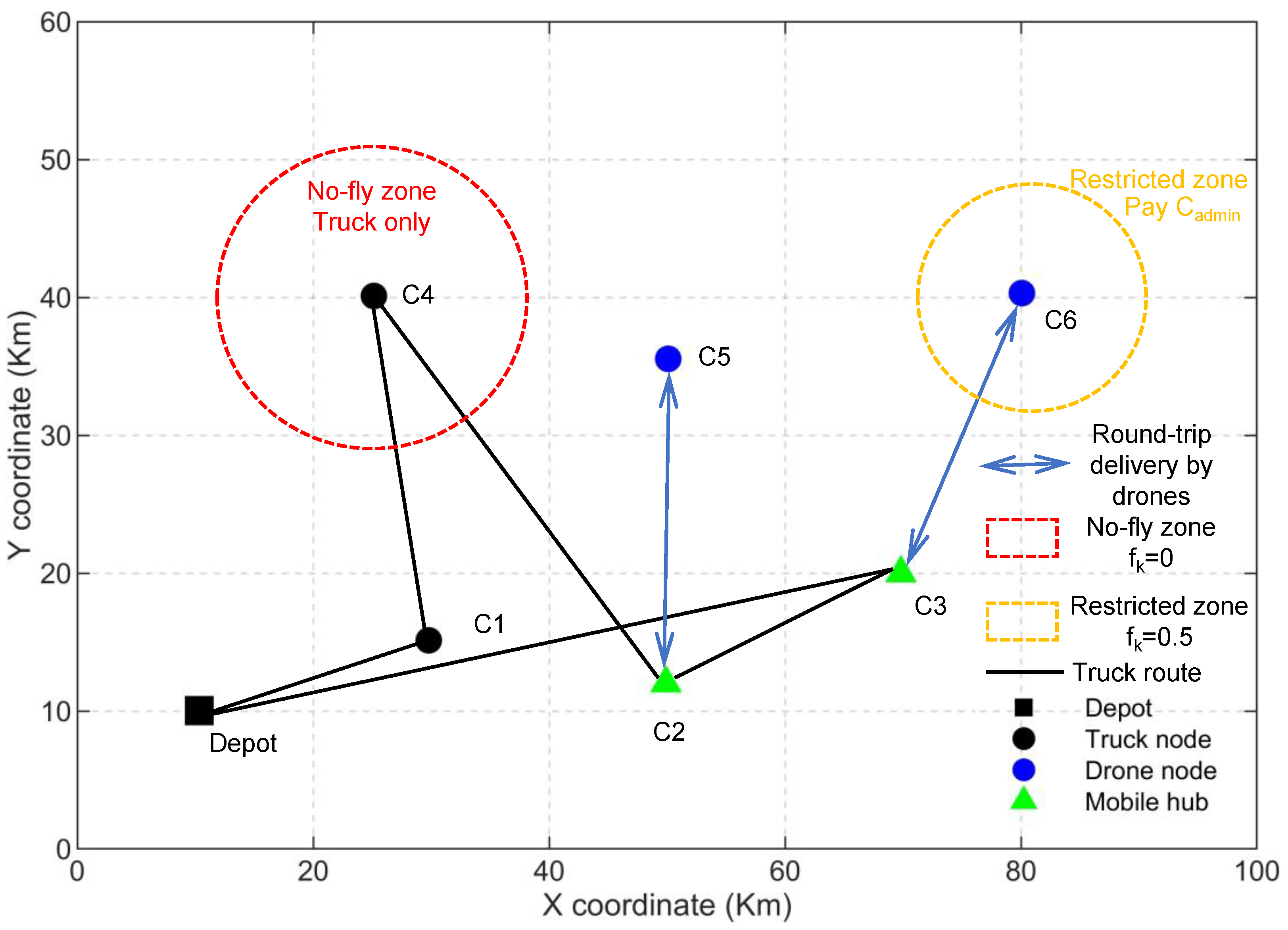
General Flyable Zone (): Corresponds to legally “Unrestricted Airspace” (e.g., rural villages in Longjing County). The indicator permits free drone routing without triggering any administrative cost penalties in the objective function.
Prudent Restricted Zone (): Represents “Controlled Airspace” (e.g., buffer zones near the Tumen River border or Yanji Airport). While UAV operations are permissible, they are strictly conditional upon prior route approval. Mathematically, triggers the addition of a fixed administrative compliance cost () to simulate the mandatory labor and time resources required for these protocols.
Hard No-Fly Zone (): Defined as “Prohibited Airspace” (e.g., core national border lines like the Nanping Port area). The indicator mathematically forces the drone assignment variable to zero, strictly prohibiting aerial operations and necessitating exclusive truck service.
By grounding the parameter
in actual legislative frameworks and geographic realities, the optimization model bridges the gap between theoretical routing and institutional compliance. To visually synthesize this operational framework,
Figure 1 illustrates a schematic of the collaborative delivery mode operating under these heterogeneous airspace constraints.
3.3. Formulation of the Bi-Objective Optimization Model
Given the aforementioned problem context, we formulate a bi-objective collaborative optimization model aimed at minimizing both the total delivery cost and the delivery completion time (makespan). The total cost encompasses not only the operational and labor costs of vehicles and drones but also explicitly incorporates carbon emission costs and administrative compliance costs, reflecting the comprehensive impact of low-carbon policies and airspace management on corporate decision-making.
The model is grounded in the following basic assumptions and characteristics:
System Configuration and Demand: The network operates under a strict single truck–single drone setting, inherently dictating an absence of drone concurrency. Each customer node has a uniform delivery demand and must be served exactly once, either by the truck or via a drone sortie.
Kinematics and Temporal Simplifications: Vehicles and drones operate at fixed average speeds, neglecting stochastic variations such as sudden weather changes. While service (drop-off) times at customer nodes are treated as negligible and ignored, the mandatory operational time required for mobile base station activation and drone battery swapping () is strictly accounted for.
Airspace Preprocessing and Range Limits: Drones are strictly constrained by a maximum physical flight range (). To enforce institutional airspace regulations while preserving model tractability, a spatial preprocessing mechanism is applied prior to optimization: any straight-line drone flight path intersecting a Hard No-Fly Zone () is pre-evaluated and penalized to infinity ().
Economic Equivalence: Cost calculations follow the Life Cycle Cost Analysis (LCCA) philosophy. Fixed capital investments (e.g., vehicle and drone purchases) are converted into equivalent daily operational costs to enable consistent integration with variable routing costs and carbon emission taxes.
3.3.1. Objective Functions and Notation
(1) Minimization of Total Cost ()
The total cost encompasses the fixed capital amortization, driver wages, vehicle routing variable costs (fuel and maintenance), drone variable costs, operational battery swapping costs, administrative compliance costs, and carbon emission taxes. Crucially, to ensure unit consistency, the carbon emissions are converted from kilograms to metric tons before applying the carbon price (
). Furthermore, the battery swapping cost (
) is strictly calculated per drone sortie (
), reflecting the true operational effort.
(2) Minimization of Delivery Completion Time (Makespan) ()
To accurately model the synchronization between the truck and the drone in the Flying Sidekick (FSTSP) framework, the temporal sequence must be rigorously decomposed. When a drone is deployed from node i to serve customer k and recovered at a subsequent node j, the physical process involves three phases: (1) Preparation: the truck halts at node i for to perform battery swapping and loading; (2) Parallel Travel: the drone flies while the truck proceeds toward node j; (3) Synchronization: the vehicle that arrives earlier at j must wait for the other.
Therefore, the total completion time (makespan) is the sum of the truck’s actual travel time along its route, the mandatory stationary preparation time for each drone sortie, and the synchronization waiting time at rendezvous nodes (
):
where the synchronization waiting time incurred by the truck at the recovery node
j is rigorously defined as:
Here, denotes the actual elapsed time for the truck to travel from node i to node j along its assigned route (i.e., , where A represents the arrival time variable). This formulation dynamically accounts for any intermediate stops the truck might make between launching and recovering the drone, ensuring an exact temporal accounting.
Notation and Parameters:
Sets:
N: Set of customer nodes, indexed by
: Set of all nodes including the distribution center (depot 0), denoted as .
Physical and Operational Parameters:
: Actual road network distance for the truck between node i and node j.
: The shortest collision-free flight distance for the drone between node i and node j.
: Average travel speed of the truck and average flight speed of the drone, respectively.
: Maximum round-trip flight range of the drone.
: Regional flyability factor for customer node k, taking values from .
: Time required for a single battery swapping and launching operation per drone sortie.
Handling Path Feasibility Under Airspace Restrictions
To rigorously ensure that drone flight paths do not violate Restricted or No-Fly Zones, we abandon the simplistic assumption of continuous Euclidean distances. Instead, a spatial pre-processing step is employed. Prior to optimization, any straight-line drone path intersecting a predefined No-Fly Zone buffer is recalculated or penalized. If a viable path cannot be found without violating the restriction, the distance is penalized to infinity (∞). This approach transforms complex geometric constraints into static edge weights, guaranteeing path-level regulatory compliance while preserving model tractability.
Economic and Environmental Parameters:
: Daily fixed costs for the truck and the drone (calculated based on Life Cycle Cost Analysis, LCCA).
: The daily wage of the truck driver and the hourly wage rate of the skilled drone operator, respectively.
: The total daily baseline labor cost. Given the single-truck configuration, this is defined as the driver’s daily wage ().
: Variable costs per unit distance for the truck and the drone (including fuel/energy consumption and maintenance), respectively.
: Operational cost for a single battery swapping and launching operation, calculated as a function of the operator’s wage, handling time, and a fixed overhead for battery wear and truck idling ().
: Administrative compliance cost incurred per visit in a Prudent Restricted Zone (), derived from the required filing and approval time ().
: Unit price of carbon emissions (scenario variable, measured in CNY/ton).
: Carbon emission factors for the truck and the drone (measured in kg/km), respectively.
Decision Variables:
: Binary variable. Equal to 1 if the truck travels directly from node i to node j; 0 otherwise.
: Binary variable. Equal to 1 if customer k is served by the drone; 0 otherwise.
: Binary variable. Equal to 1 if the truck stops at node j to activate the mobile base station function; 0 otherwise.
: Binary variable. Equal to 1 if a drone is launched from node i to serve customer k and is recovered at node j; 0 otherwise.
: Continuous variable representing the arrival time of the truck at node i.
: Continuous variable representing the actual elapsed time for the truck to travel from node i to node j, calculated as .
3.3.2. Constraints
The optimization model is subject to the following sets of constraints:
1. Customer Service and Flow Balance Constraints
These constraints ensure that each customer node is served exactly once, either directly by the truck or by a drone sortie. Additionally, they guarantee flow conservation for the truck, ensuring its route forms a continuous closed loop that starts from and returns to the distribution center.
2. Regional Flyability Constraints (Hard Constraints)
To strictly enforce airspace regulations, specific constraints are imposed based on the Regional Flyability Factor ():
For customers in Hard No-Fly Zones (), drone delivery is strictly prohibited, necessitating the constraint (forcing truck service).
For customers in Prudent Restricted Zones () or General Flyable Zones (), drone delivery is permissible (). However, choosing the drone mode in restricted zones will incur the corresponding administrative costs defined in the objective function.
3. Drone Launch and Mobile Base Station Constraints
These constraints dictate the parallel launch and recovery logic. A drone can only be launched from an active mobile hub (
) and recovered at a subsequent active hub (
).
4. Drone Range Constraints
The total distance of a drone’s parallel sortie (Launch Node
Customer Node
Return Node
j) must not exceed its maximum physical flight range (
).
5. Subtour Elimination Constraints
To guarantee route connectivity and prevent the formation of isolated subtours (i.e., ensuring the truck does not form disjoint loops among customer nodes without passing through the depot), the classical Miller-Tucker-Zemlin (MTZ) formulation is employed:
6. Variable Domain Constraints
These constraints strictly define the domains of the decision variables within the model.
4. Solution Methodology and Algorithm Design
The VRPDBS model proposed in this study is a highly constrained variant of the VRP-D, characterized by disjoint feasible regions due to airspace regulations. Standard metaheuristics often struggle in such environments, as conventional random mutations frequently generate solutions that violate No-Fly Zone constraints, leading to heavy penalties and premature convergence.
To overcome this, we propose a hybrid solution framework that integrates the global multi-objective exploration capabilities of the Non-dominated Sorting Genetic Algorithm II (NSGA-II) [
38] with the local, constraint-aware intensification strengths of Adaptive Large Neighborhood Search (ALNS) [
24].
4.1. Hybrid Algorithmic Architecture
Our hybrid approach follows a “Global Evolution – Local Repair” architecture. Instead of allowing the algorithm to waste computational resources evaluating invalid topological structures, the ALNS module acts as a “smart spatial filter” nested within the evolutionary loop.
The algorithm proceeds in two coupled phases:
- 1.
Phase 1: Global Evolution (NSGA-II). The algorithm maintains a diverse population of collaborative scheduling schemes. Each chromosome is encoded into three parts: a truck route sequence (permutation), a delivery mode vector (binary: truck or drone), and a base station deployment vector (binary). Standard order crossover (OX1) and swap mutations are applied to explore the broad trade-off space between operational cost and completion time.
- 2.
Phase 2: Local Enhancement (ALNS). At the end of each generation, the ALNS process is triggered specifically for the elite individuals (Rank 1 on the Pareto front). Through competitive “Destroy” and “Repair” operators, ALNS dynamically adjusts truck routes and drone task assignments to bypass no-fly zones and repair penalized genes. If an ALNS-improved solution dominates the original one, it replaces it in the population, ensuring that the algorithm penetrates barriers imposed by hard airspace constraints.
4.2. Smart Decoding and Constraint-Aware Repair Mechanism
Given the complex airspace constraints in mountainous areas, chromosomes generated by standard genetic operators often map to infeasible physical routes. To bridge the gap between the continuous optimization space and the discrete regulatory environment, we introduce a Smart Decoding and Repair Mechanism prior to objective function evaluation.
4.2.1. Decoding and Feasibility Filtering
The decoding process strictly adheres to the institutional constraints defined by the Regional Flyability Factor ():
Airspace Compliance Check: The algorithm scans the Delivery Mode Vector. If a customer node located in a Hard No-Fly Zone () is erroneously marked for drone delivery by a genetic mutation, the mode is forcibly corrected to truck delivery.
Base Station Validity: Mobile base stations are only permitted to be activated at nodes actually visited by the truck. Unvisited hub deployments are automatically deactivated to maintain operational logic.
4.2.2. Collaborative Repair Operators (ALNS)
The core innovation of the ALNS module lies in its constraint-aware repair operators. When a solution is perturbed (e.g., via random or worst-cost removal of customer nodes), the re-insertion process evaluates the spatial feasibility of drone deployment in real-time.
For each customer awaiting re-insertion, a Collaborative Greedy Insertion Operator iterates through all currently active mobile base stations. Crucially, a base station is considered a valid launch node only if the flight path to the customer satisfies battery endurance limits () and does not intersect any prohibited airspace (pre-verified via the visibility graph, where ).
If a viable drone path cannot be found without violating the restriction, the operator invokes a “Truck Rescue” logic. The task is forcibly reassigned to the truck, incurring a localized penalty in both travel distance and time based on the nearest available truck route node. The operator then compares the incremental costs of “Truck Rescue” versus “Drone Insertion (via the best legal base station)” and selects the mode with the minimum objective penalty.
By utilizing a roulette wheel mechanism to adaptively select between different destroy and repair strategies based on their historical success rates, this mechanism achieves a dynamic, physics-informed coupling of truck routing, drone scheduling, and base station location decisions.
5. Simulation Setup and Results
This section presents the numerical simulation conducted to validate the proposed model and algorithm. First, we elucidate the data sources, parameter settings, and the simulation environment. Subsequently, the convergence performance of the hybrid heuristic is verified through comparative experiments. We then provide an in-depth analysis of the macroscopic impacts of airspace regulations on network efficiency and the resulting microscopic shifts in operational modes. Finally, a multi-scenario carbon price sensitivity analysis is performed to evaluate the economic robustness of different operational strategies.
5.1. Dataset and Case Study Description
To validate the effectiveness of the proposed VRPDBS model and the hybrid heuristic algorithm, this study constructs numerical experiments based on a typical mountainous delivery scenario in the Yanbian Korean Autonomous Prefecture. Information regarding customer node locations, road networks, and terrain is derived from real-world geographical data and pre-processed using GIS tools to ensure the realistic representation of the experimental scenarios. Specifically:
Node Data: A logistics distribution point in Yanji City is selected as the central Depot. Additionally, 30 administrative villages exhibiting typical mountainous characteristics within the Yanbian Prefecture are selected as Customer Nodes.
Road Network Data: Following the methodology of Stuive (2024), the OSMNX Python 3.12.3 library is utilized to extract real-world road network data from OpenStreetMap (OSM). This data is used to calculate the actual travel distance matrix for trucks, reflecting the winding nature of mountain roads.
Airspace Constraint Data: In accordance with the
Interim Regulation on the Flight Management of Unmanned Aerial Vehicles, restriction sources such as airports, border lines, and critical infrastructure are identified. Spatial buffer analysis is then performed to generate the Regional Flyability Factor (
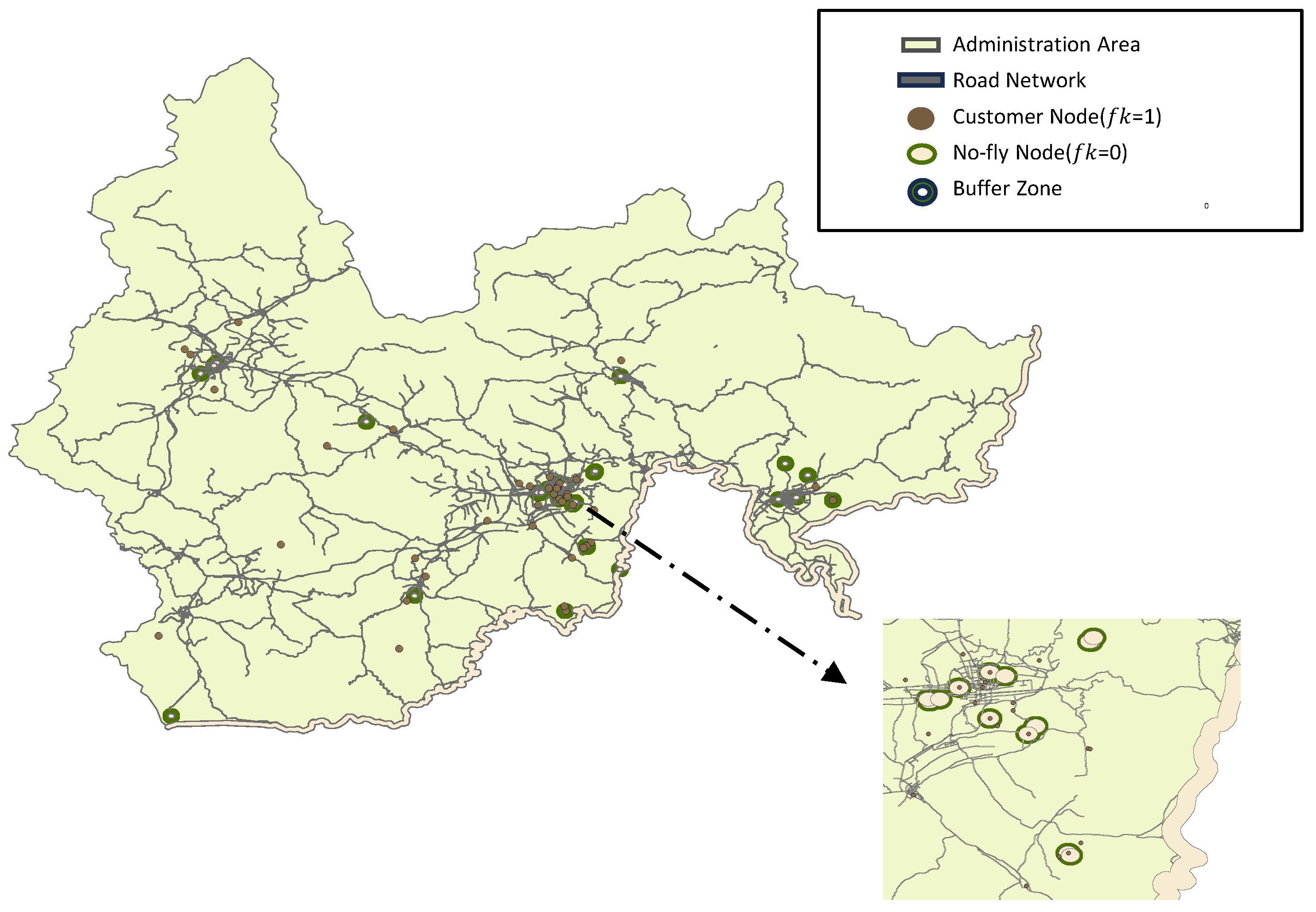
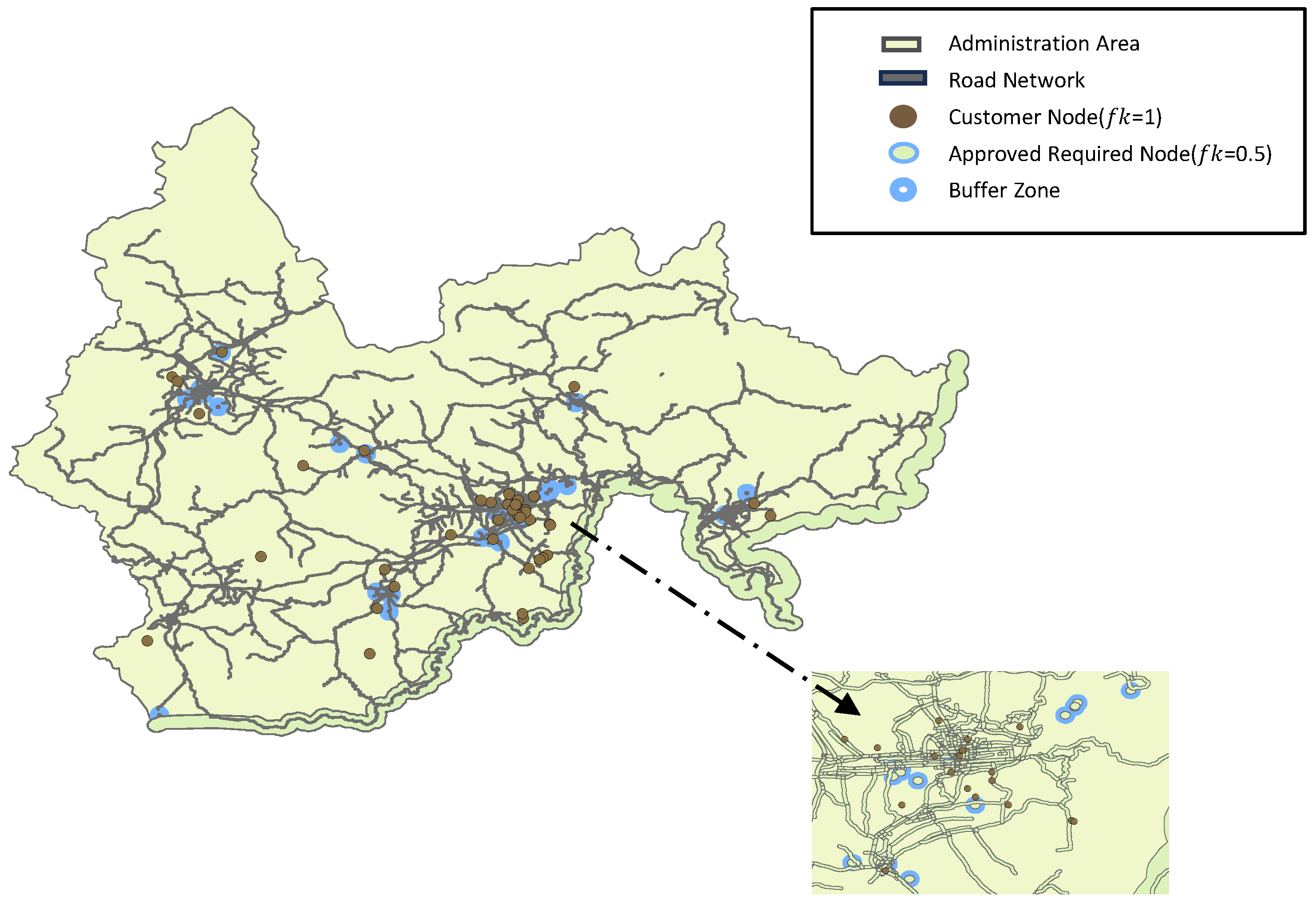
) for each node, quantifying the specific airspace constraints. The visualization of these flyability factors is presented in
Figure 2 (Hard No-Fly Zone) and
Figure 3 (Prudent Restricted Zone).
The operational parameters for both trucks and drones are calibrated based on existing literature and practical operational experience.
Airspace Policy Settings:
To explicitly capture the impact of airspace policy constraints on the delivery system, different Regional Flyability Factors are assigned based on the zone type of each customer node. Furthermore, corresponding administrative compliance costs are introduced for operations within Prudent Restricted Zones. To mitigate the impact of stochasticity on the results, multiple independent runs were conducted for each scenario.
Simulation Environment:
All simulation experiments were implemented in MATLAB R2022b and executed on a workstation equipped with an Intel Core i5-13600KF processor (2.27 GHz) and 32 GB of RAM.
Algorithm Parameters: The parameters for the hybrid NSGA-II-ALNS algorithm are configured as follows:
Population Size () = 200
Maximum Iterations () = 1000
Crossover Probability () = 0.85
Mutation Probability () = 0.25
ALNS Local Search: Executed for elite individuals (Rank 1) in each generation, with an inner loop iteration count of 20.
5.2. Macroscopic Diagnosis: The Systemic Cost of Airspace Regulations
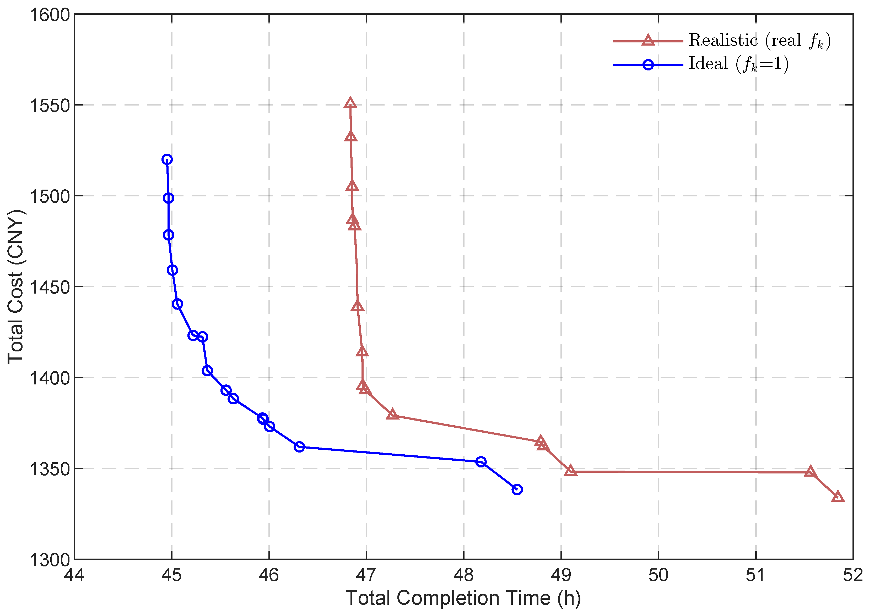
To quantify the impact of real-world airspace policies on the logistics system, we compare the Pareto optimal frontiers obtained under the “Ideal Scenario” (unrestricted airspace, where all
) versus the “Realistic Scenario” (actual
based on current regulations). The results are illustrated in
Figure 4.
Experimental results indicate that the realistic frontier (red curve) is located significantly to the upper-right of the ideal frontier (blue curve). Specifically, compared to the ideal unrestricted environment, compliance with real-world airspace regulations necessitates a significant time delay of 4 to 5 h and an operational cost premium of up to 15% to maintain service coverage.
Notably, our findings suggest that the proposed VRPDBS model has effectively pushed the system toward its technological frontier. The persistent gap between the realistic performance and the ideal limit is not a limitation of our metaheuristic algorithm, but rather a “regulatory cost” imposed by institutional airspace barriers. While truck-drone collaboration significantly reduces carbon footprints, our analysis reveals that in border mountainous regions, the potential for further carbon mitigation is heavily constrained by airspace inflexibility. This implies that purely operational optimization—no matter how advanced—cannot fully bridge the gap without adaptive airspace governance, such as the introduction of dynamic low-altitude flight corridors.
Shift in the Time Lower Bound: In the Ideal Scenario, the absence of airspace restrictions allows the drone to maximize its parallel delivery potential, resulting in highly efficient routing with completion times starting around 45.5 h. Conversely, in the Realistic Scenario, the presence of No-Fly Zones forces the drone to remain grounded for certain customers, compelling the truck to traverse longer, winding mountainous roads to compensate. This topological fragmentation delays the minimum possible completion time to approximately 49 h, exposing the physical limits of a single-truck-single-drone system under strict institutional constraints.
Asymmetrical Efficiency Gap: Notably, the efficiency gap is asymmetrical. At the time-prioritized extreme (the upper-left of the Pareto front), the Realistic scenario suffers a significant time delay compared to the Ideal scenario. This indicates that physical No-Fly Zones impose a hard limit on delivery speed that cannot be overcome simply by tolerating higher operational costs. Conversely, at the cost-prioritized extreme (the lower-right), the gap narrows. This occurs because cost-minimizing strategies rely more heavily on the truck, which operates on the ground and is largely immune to airspace restrictions. This non-linear relationship underscores a critical managerial insight: while drone integration accelerates delivery, it exposes the network to regulatory bottlenecks, necessitating a strategic balance in fleet configuration based on regional flyability.
5.3. Algorithmic Validation and Ablation Study
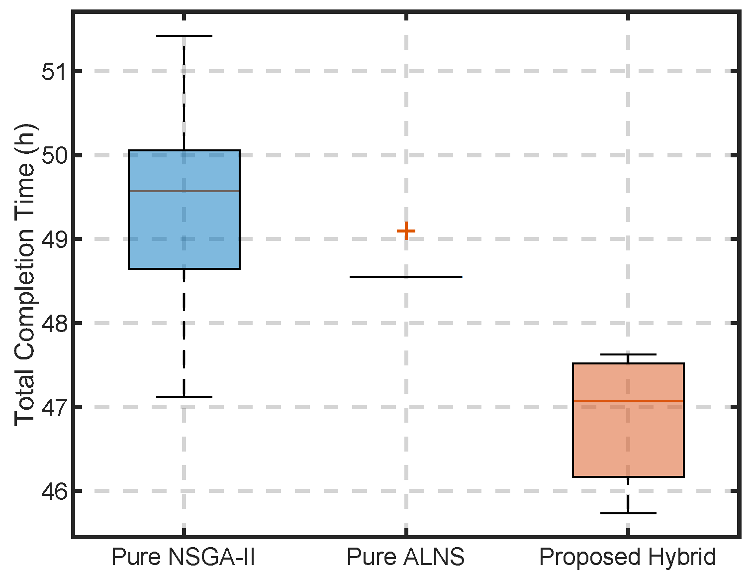
To address the highly fragmented feasible region induced by airspace restrictions, our proposed approach integrates an Adaptive Large Neighborhood Search (ALNS) repair mechanism into the traditional NSGA-II framework. To rigorously validate the necessity and superiority of this hybridization, an ablation study was conducted. We compared the performance of the Proposed Hybrid (NSGA-II + ALNS) against a Pure NSGA-II and a Pure ALNS.
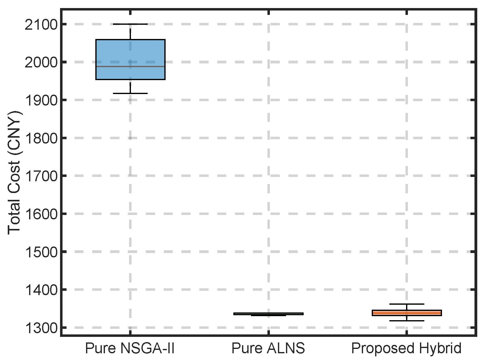
The comparison was executed under the Realistic Scenario over 30 independent runs to ensure statistical robustness. The results, summarizing the convergence to the lowest operational cost and completion time on the Pareto front, are presented in
Table 2 and visually distributed in the boxplots of
Figure 5 and
Figure 6.
The Proposed Hybrid successfully marries the global exploratory power of NSGA-II with the constraint-handling precision of ALNS, achieving the lowest mean completion time while maintaining robust cost efficiency. Although the hybridization incurs a marginal computational increase (averaging 52.8 s compared to 45.3 s for Pure NSGA-II), this is a highly acceptable trade-off for strategic-level planning given the drastic improvement in solution quality (over 33% cost reduction vs. Pure NSGA-II).
Furthermore, to confirm that the superior performance of the proposed algorithm is robust, a comprehensive parameter sensitivity analysis (evaluating variations in
,
, and
) was conducted. The results, detailed in
Appendix A, demonstrate that the algorithm achieves stable convergence independently of specific parameter configurations.
5.4. Microscopic Analysis: Reconfiguration of Operational Modes
To investigate the internal mechanisms driving this efficiency loss, we selected the “Knee Point” solutions (representing a balanced trade-off between cost and time) from both scenarios. We then conducted a comparative analysis of their route structures and resource allocations.
5.4.1. Topological Variations in Routing
Ideal Scenario: The delivery network exhibits a typical “Star-shaped” topology. Drone utilization is maximized, radiating outwards from the distribution center or a few select base stations to cover the majority of customers, while trucks function primarily as the backbone for arterial transportation.
Realistic Scenario: The network transforms into a hybrid structure characterized by “Zigzag” truck routes and “Local Star” drone clusters. Due to the high concentration of villages within hard no-fly zones (), trucks are compelled to execute long-distance detours to service these “coverage blind spots.” Consequently, this leads to a substantial increase in truck mileage compared to the ideal case.
5.4.2. Strategic Relocation of Mobile Base Stations
In the Realistic Scenario, the optimization model demonstrates an intelligent adaptation by autonomously adjusting the deployment locations of mobile base stations.
Shift in Logic: Instead of prioritizing mere geometric centrality relative to customer clusters, the model tends to position base stations along the periphery of restricted zones.
“Edge Springboard” Strategy: This phenomenon, which we term the “Edge Springboard” strategy, enables drones to maximize the utilization of the remaining navigable airspace, thereby serving remote mountainous nodes that are otherwise difficult or costly for trucks to access.
5.4.3. Degradation of Collaborative Modes
Experimental results reveal that the proportion of drone-delivered shipments in the Realistic Scenario experienced a sharp decline of approximately 40% compared to the Ideal Scenario.
Paradigm Shift: This indicates that stringent airspace regulations force the system to regress from a “High-Synergy” mode to a “Truck-Dominant, Drone-Supplementary” paradigm.
Economic Implication: This structural regression is identified as the fundamental driver behind the significant escalation in operational costs and time.
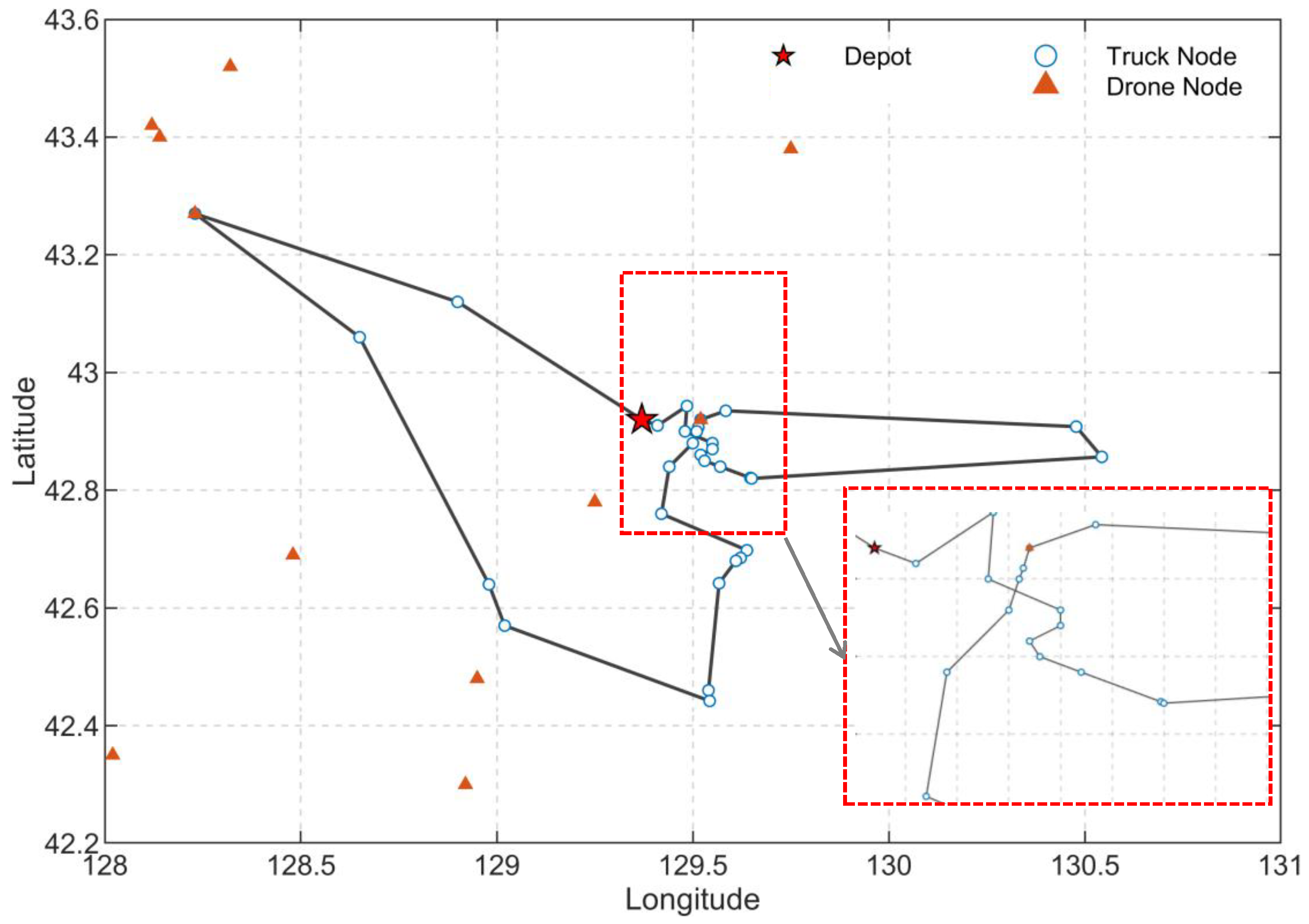
To visually demonstrate this paradigm shift,
Figure 7 presents the optimized collaborative route sequence under realistic constraints, highlighting the interplay between truck detours and drone sorties.
5.5. Prospective Evaluation: Economic Robustness Under Carbon Price Fluctuations
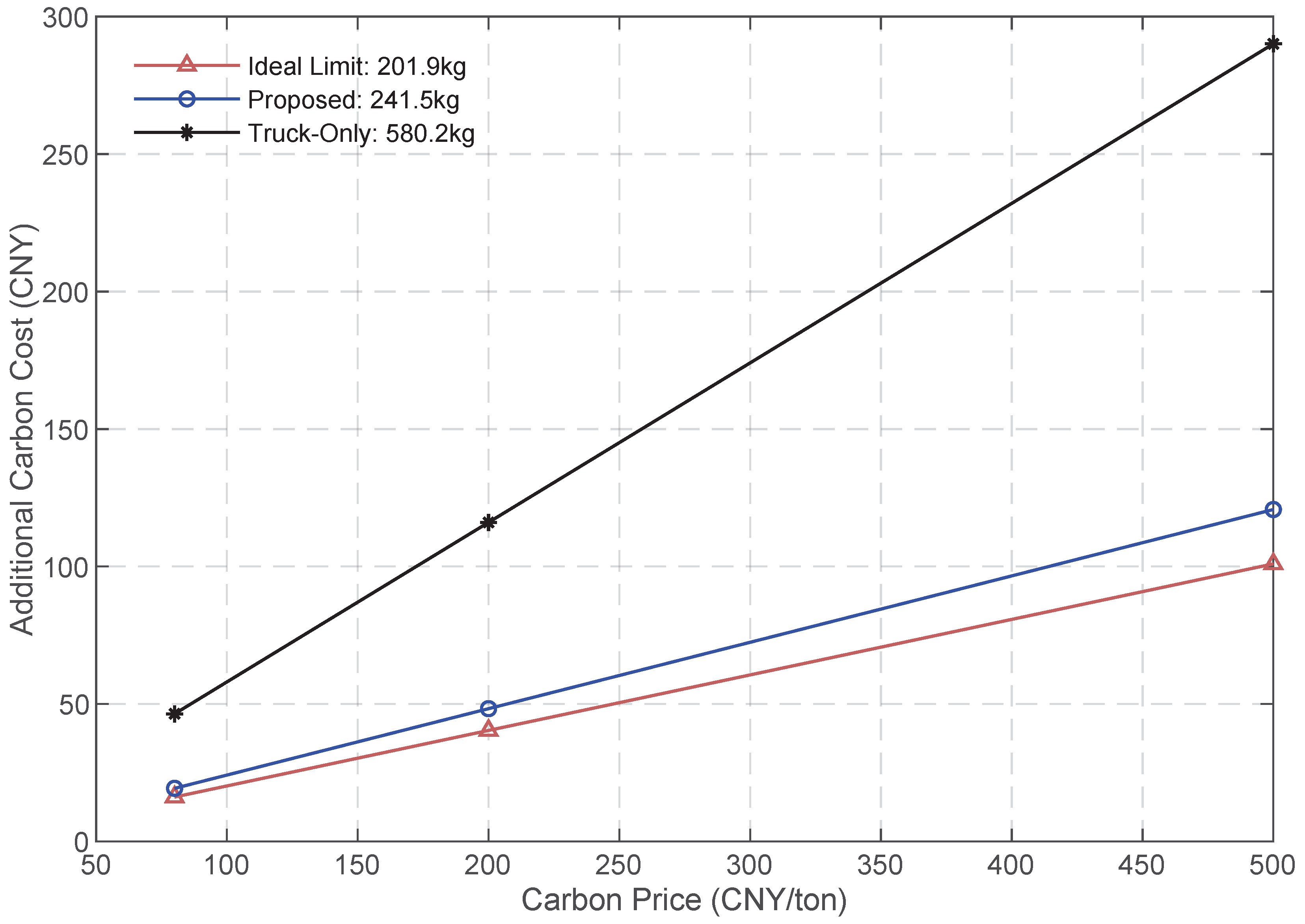
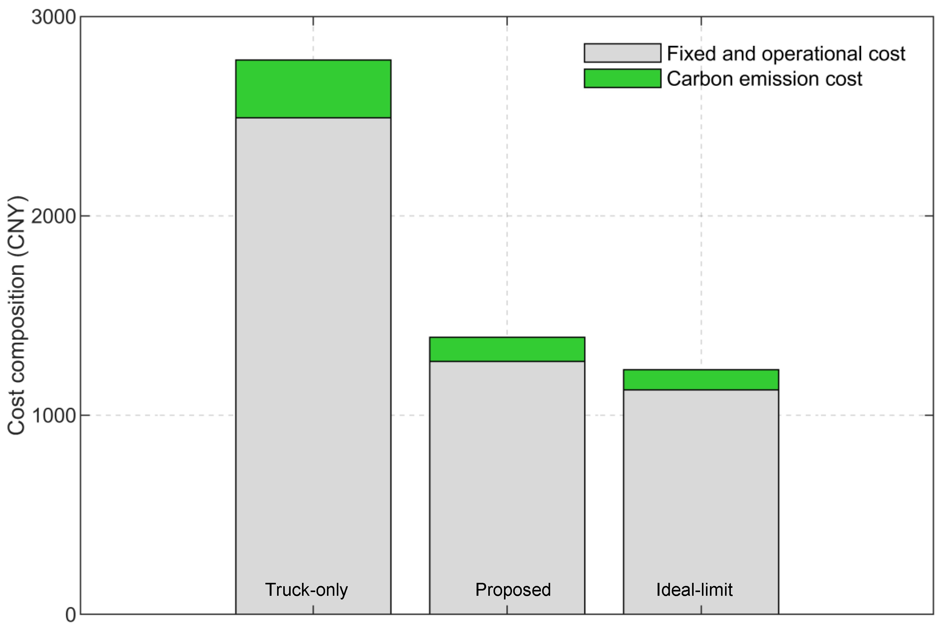
To evaluate the strategic hedging capability of the proposed VRPDBS model, we analyzed the cost structure of three representative strategic configurations: Truck-Only (Baseline), Proposed VRPDBS (Realistic), and Ideal Limit (Optimal Potential). Based on our rigorous physical emission calculations, which strip away penalty costs to reflect actual energy consumption, the baseline carbon emissions for these strategies are 580.2 kg, 241.5 kg, and 201.9 kg, respectively. We then evaluated the total cost variations of these strategies under three carbon price scenarios—Low (80 CNY/ton), Medium (200 CNY/ton), and High (500 CNY/ton)—based on international carbon pricing forecasts.
Figure 8 illustrates the sensitivity analysis regarding the impact of carbon price fluctuations on each strategy:
Vulnerability of the Truck-Only Strategy: The black line exhibits the steepest gradient, making it highly vulnerable to climate policy uncertainty. Relying entirely on fossil-fueled trucks, this strategy generates substantial carbon emissions. At a high carbon price of 500 CNY/ton, the additional carbon tax burden approaches 300 CNY per route, demonstrating a high degree of risk exposure to tightening environmental policies.
Robustness of the Collaborative Strategies: In contrast, both the Proposed VRPDBS (blue Solid lines) and the Ideal Limit (red Solid lines) display significantly flatter slopes. Characterized by the extensive utilization of energy-efficient drones, the proposed collaborative system slashes carbon emissions by nearly 58% compared to the baseline. Regardless of how drastically carbon prices rise, the fluctuation in total cost remains heavily suppressed. This validates the “strategic hedging” value of fixed investments in drone technology—essentially “locking in” low future emissions to immunize operations against policy risks.
Quantifying the Regulatory Cost: The slight gap between our Proposed VRPDBS (241.5 kg) and the Ideal Limit (201.9 kg) visually quantifies the “regulatory cost” imposed by current airspace constraints. It highlights that while operational algorithms can mitigate risks, further decarbonization in border regions is hindered by institutional inflexibility.
This robustness is further elucidated in
Figure 9, which breaks down the cost structure at a medium carbon price (200 CNY/ton). The results demonstrate that while the collaborative systems require slightly higher fixed investments, their carbon emission costs (green segments) are negligible compared to the truck-only baseline. This confirms that the proposed framework is not only operationally efficient but also serves as a robust financial hedge against volatile carbon markets.
6. Conclusions and Future Research
This study investigates a truck–drone collaborative last-mile delivery problem in mountainous border regions under strict airspace regulation. By incorporating regional flyability constraints and mobile base station deployment decisions, a Vehicle Routing Problem with Drones and Mobile Base Stations (VRPDBS) is formulated to better reflect real-world operational conditions. A hybrid NSGA-II–ALNS algorithm is developed to solve the resulting bi-objective optimization problem, and numerical experiments based on data from the Yanbian Korean Autonomous Prefecture are conducted to evaluate the effectiveness of the proposed approach.
6.1. Theoretical Contributions
From a theoretical perspective, this study contributes to the truck–drone collaborative delivery literature by extending existing VRP-D models to regulated airspace environments. Unlike conventional formulations that assume free and homogeneous airspace, the proposed VRPDBS explicitly captures spatial heterogeneity in airspace accessibility and regulatory compliance requirements. In addition, the introduction of mobile base stations enriches the modeling of truck–drone interaction by allowing more flexible drone deployment strategies, particularly in mountainous regions where direct truck access is limited. Methodologically, the study also contributes by integrating heterogeneous decision variables and feasibility constraints within a unified bi-objective optimization framework.
6.2. Practical Implications
The findings of this study offer critical implications for logistics operators and policymakers. The computational results indicate that truck-drone collaboration, even under strict airspace regulations, reduces carbon emissions by nearly 58% compared to traditional truck-only delivery.
A critical question arises: are the 4–5 h of delivery delay and the 15% cost premium acceptable for rural logistics? From a commercial standpoint, this premium is a necessary “investment in equity.” In mountainous border regions, conventional truck-only delivery often takes days or fails entirely due to geographic isolation. By absorbing a 15% regulatory premium, operators can still guarantee sub-48-h delivery windows via mobile base stations, successfully bridging the rural-urban digital divide. This structural resilience directly operationalizes SDG 10 (Reduced Inequalities), ensuring that remote populations receive reliable e-commerce access without compromising the operator’s legal standing.
Furthermore, for logistics operators, our results demonstrate that deploying mobile base stations is not merely an operational upgrade; it acts as a “strategic hedge” against future carbon price volatility. For policymakers, the persistent gap between the realistic model and the ideal limit suggests that operational algorithms alone cannot overcome rigid institutional barriers. To unlock further environmental and social benefits, we recommend the establishment of “Dynamic Drone Corridors,” which would lower the compliance barriers explicitly quantified in our model, fostering a truly inclusive rural logistics ecosystem.
6.3. Limitations and Future Research
Despite its contributions, this study has several limitations that outline critical directions for future research. First, the evaluation of aerial operations relies on a simplified airspace modeling approach. While the Regional Flyability Factor () quantifies institutional and regulatory restrictions on a two-dimensional plane, the preprocessed physical flight paths () assume a flat-earth topology with a constant energy consumption rate (). In actual mountainous topographies, vertical elevation gains dictate battery depletion dynamics far more severely than horizontal travel. Future formulations must integrate 3D elevation profiles and stochastic, weather-dependent aerodynamic models to prevent overestimating the UAV’s effective service radius.
Second, the current model focuses strictly on routing and scheduling, exposing an absence of fleet sizing decisions. By constraining the framework to a single truck–single drone baseline, the model structurally prohibits the evaluation of drone concurrency. In highly fragmented networks where the truck is forced to detour around No-Fly Zones, relying on a single drone creates a severe throughput bottleneck. Extending the vehicle routing problem to multi-truck and multi-drone configurations—thereby treating fleet scale and composition as endogenous decision variables—would allow multiple UAVs to operate concurrently from mobile hubs. This expansion is essential for capturing the true economies of scale required for real-world, regional-level logistics deployment. Finally, integrating dynamic customer request arrivals and real-time traffic data would further enhance the resilience of the collaborative network.