Article

Harmonisation of Navigation Signs on Inland Waterways in Poland with European Regulations to Improve Navigation Safety


1
National Water Management Authority, State Water Holding Polish Waters, 00-613 Warsaw, Poland
2
Faculty of Geographical Sciences, Kazimierz Wielki University, 85-033 Bydgoszcz, Poland
3
Regional Water Management Authority in Szczecin, State Water Holding Polish Waters, 70-030 Szczecin, Poland
4
Faculty of Engineering and Economics of Transport, Maritime University of Szczecin, 70-500 Szczecin, Poland
*
Authors to whom correspondence should be addressed.
Sustainability 2026, 18(8), 3844; https://doi.org/10.3390/su18083844
Submission received: 20 February 2026 / Revised: 30 March 2026 / Accepted: 8 April 2026 / Published: 13 April 2026
(This article belongs to the Special Issue Transportation and Infrastructure for Sustainability)

Abstract

Navigation marking is an essential element of inland waterways. The visibility, location, and quality of navigation signs determine navigation conditions. Therefore, this study aimed to identify opportunities to improve navigation safety on inland waterways in Poland. Particular attention was paid to Polish legislation and international regulations in order to identify discrepancies and propose amendments to individual legal acts. These recommendations were preceded by field studies of selected navigation signs, including assessments of their legibility at night and in conditions of limited visibility. On this basis, and drawing on many years of practical experience on navigable waterways in Poland and Western European countries, the authors developed original proposals for the use of navigation signs, including designs for floating navigation signs and bridge clearance signs, as well as concepts for navigation marking plans for selected infrastructure components related to inland waterways. The proposed measures are expected to improve the recognisability and consistency of navigation markings, which may contribute to better operating conditions for inland waterway users, including both professional inland navigation operators (freight and passenger) and individual recreational users.

1. Introduction

Inland waterways are extensive systems consisting of natural and regulated sections of rivers and lakes, as well as artificial canals, used for the transport of passengers and cargo [1]. Individual sections are often subject to inconsistent standards across waterway classes, which affects safety levels [2]. The diversity of inland waterway sections also influences the navigation signs used [3,4]. Proper navigation signs are one of the key factors affecting the safety of users, including both professional inland waterway transport operators (freight and passenger) and individual tourist users [5]. Recommendations for improving safety conditions on inland waterways, including reducing collisions, emphasise the need to install a sufficient number of navigation signs (cardinal and lateral marks, buoys, etc.) at the required locations for both day and night navigation [6].
Research on inland waterway navigation safety has traditionally focused on traffic management [7], hydrological constraints [8], and vessel operations [9], while navigation marking systems have received comparatively less systematic academic attention. Nevertheless, several studies have highlighted the importance of clear and standardised navigation aids for safe vessel manoeuvring and traffic organisation on inland waterways, including research on automatic navigational buoy recognition [10] and buoy behaviour and stability in the Automatic Identification System [11]. Other works analysing accident databases and operational safety in inland navigation also emphasise the role of different navigational systems [12,13,14].
In Poland, attention is also drawn to the need for the systematic modernisation of signage, which is in line with European trends [15], and the need to harmonise regulations and implement modern technical solutions [16]. The European Commission also confirms the need to harmonise many aspects of inland navigation and inland waterways, including the implementation by Member States of European regulations into national legislation [17], and in this respect, the application of the “European Code for Signs and Signals on Inland Waterways” (SIGNI) and the “European Code for Inland Waterways” (CEVNI) may contribute to reducing the number of incidents on inland waterways.
Notwithstanding the above, it should be remembered that inland waterway transport is considered sustainable and the safest mode of transport in Europe due to the low number of fatalities and casualties on inland waterways [18,19,20]. Nevertheless, in an era of challenges related to climate change, we can expect a deterioration in navigation conditions on individual inland waterways, e.g., in terms of water level fluctuations and the resulting effects on costs and reliability [21]. The safe manoeuvrability of a vessel depends on the available water depth in the navigation area in relation to the draught of the vessel [22]. As in other countries, droughts can seriously disrupt inland waterway transport services, reducing water levels to completely unnavigable levels or to levels that force operators to reduce the amount of cargo on board, which directly affects the profitability of transport [23]. The changes taking place may also necessitate increased research to ensure safe navigation in poorer navigational conditions, in particular the detection of navigational obstacles in waterways with extremely shallow depths [24]. Already, one of the causes of shipping accidents is the inadequate maintenance of inland waterways, which is related to unmarked navigational obstacles in the form of drifting branches, underwater objects or shoals, which should be removed [25]. In addition to professional inland navigation, many inland waterways in Europe are intensively used by recreational users such as motorboat operators, sailors, kayakers and other tourism-related users [26]. These groups often have varying levels of navigational training and experience, which increases the importance of clear and intuitive navigation marking systems [27]. In Poland, small vessels up to 10 m in length may operate without a licence [28], which further emphasises the need for navigation signs that are easily recognisable and consistent across different waterways.
In Poland, the maintenance of inland waterways in a condition ensuring safe navigation is the responsibility of the waterway administration. This role is performed by the State Water Holding Polish Waters (Państwowe Gospodarstwo Wodne Wody Polskie), which erects and maintains navigation signs on navigable waterways and on its facilities (locks and slipways), issues navigational notices, and publishes current navigational conditions. Navigation signs in ports and on facilities, structures, and transmission lines crossing waterways are installed by their owners in agreement with the waterway administration [28]. The inland waterway administration authorities are the minister responsible for inland waterway transport and the directors of the local inland waterway offices. The minister is the head of the inland waterway administration and, among other things, supervises the directors’ activities and is responsible for legislation. The responsibilities of the directors of inland waterway administration offices include supervising the safety of inland waterway transport and inspecting the condition of navigable waterway markings, locks, slipways, bridges, waterway structures, and port entrances. The division of competences and institutional arrangements in Poland is similar to, for example, the administrative structure in the Federal Republic of Germany, where the German Federal Waterways and Shipping Administration (Wasserstraßen- und Schifffahrtsverwaltung des Bundes, WSV) is responsible for the maintenance of inland waterways [29]. In other regions, international organisations such as the Central Commission for the Navigation of the Rhine [30] and the Danube Commission [31] coordinate navigation standards among several countries.
Despite the practical importance of navigation marking systems, the issue of harmonisation between national and international regulations has not been extensively analysed in the academic literature in Poland. This creates a research gap, particularly in the context of countries where international standards such as SIGNI and CEVNI have not been fully incorporated into national legislation.
Therefore, the objective of this study was to analyse the current system of navigation marking on inland waterways in Poland and to identify possibilities for its harmonisation with European regulatory frameworks. The study aimed to identify discrepancies between Polish regulations and international standards, assess selected practical aspects of navigation mark visibility through field observations, and propose design and regulatory recommendations that could improve the recognisability and consistency of navigation marking systems. To this end, a comprehensive analysis of national and international regulations was carried out, making it possible to identify the most significant discrepancies in the legislation currently in force. On this basis, proposals were developed for the implementation of modern navigation sign solutions in Poland for use both during the day and at night, including in conditions of limited visibility.

2. Materials and Methods

2.1. Study Area

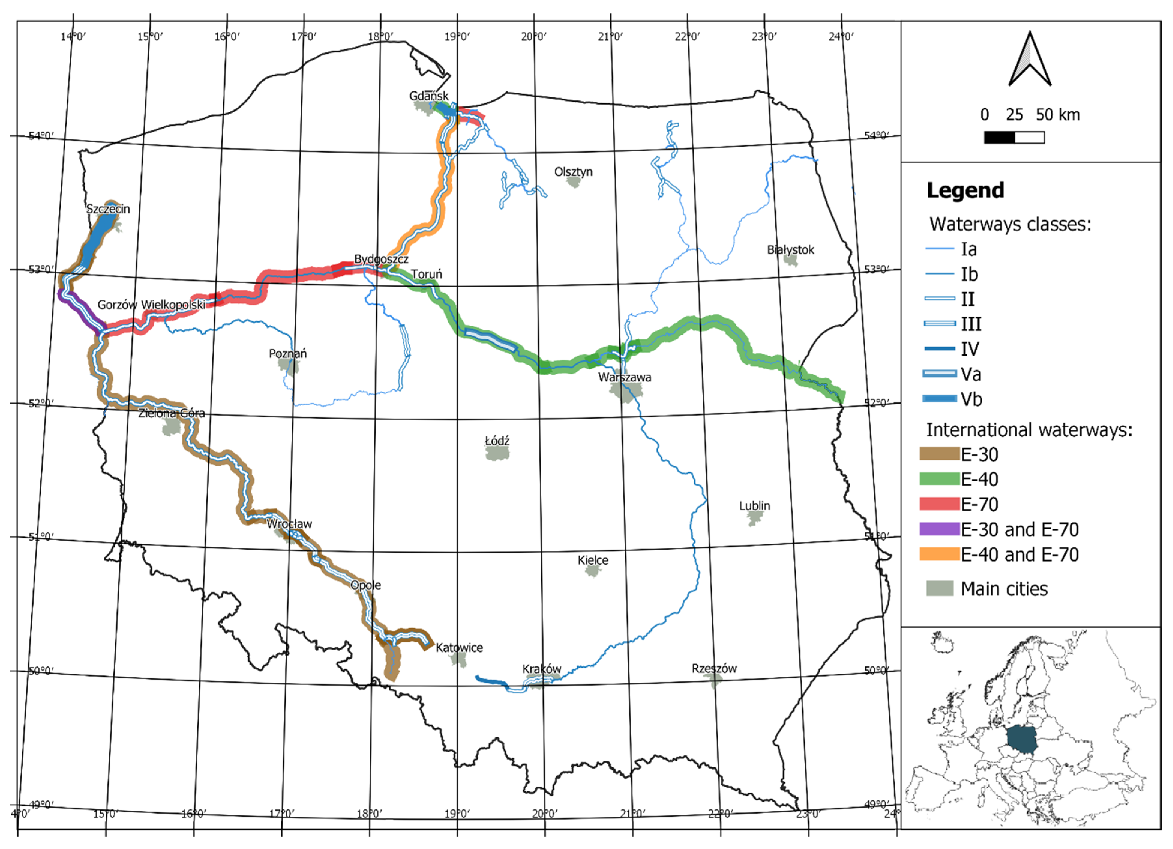
The analysis covered navigation markings used on inland waterways in Poland (Figure 1) and related legal conditions at the national and international level. The length of navigable waterways in Poland exceeds 3700 km [32], of which 3549 km was used for navigation in 2023 [33]. This is the fifth longest network in Europe, surpassed only by France (8507 km), Finland (8086 km), the Federal Republic of Germany (7675 km) and the Netherlands (7040 km) [34]. Therefore, Poland is second only to countries (except Finland) that make much greater use of inland navigation for sustainable development and transport.
Due to the diversity of navigational conditions in Poland, the study focused on selected waterway sections representing different types of inland navigation environments, including international waterways, regional waterways and urban navigation nodes. Field observations were conducted in three main locations:
  • The border section of the Oder River (international waterway, cross-border navigation conditions);
  • The Wrocław Water Junction (complex urban navigation system with intensive infrastructure);
  • The Vistula River in Kraków (regional waterway with significant tourism traffic).
These locations were deliberately chosen to represent different functional types of inland waterways, intended for professional navigation and individual users. At the same time, these were the only sections of waterways in Poland adapted to 24 h navigation, including at night, thanks to the use of reflective foil-covered markings, illuminated buoys, and radar screens on individual sections. Although the selected sites do not represent the entire Polish inland waterway network, they provide examples of typical marking problems occurring on waterways with different operational characteristics, which are known to the authors of the article due to their participation in inspection cruises and preparation of navigational marking plans on the remaining sections.
The analysed waterway sections include a total of 32 bridges (the border section of the Oder River—8, the Wrocław Water Junction—12, and the Vistula River in Kraków—12) and numerous ports and harbours, which were also included in the analysis of navigation signage.
Inland waterways in Poland vary in terms of operating parameters, which is related to their natural conditions and the degree of use of hydrotechnical infrastructure [35]. Less than 6% of them meet international requirements (classes IV–Vb), while 94% have regional operating parameters (classes Ia–III) [32]. The sections with international designation are located in different parts of the country and do not form a coherent network of waterways, which means that their potential is not being exploited [36].
At the same time, the greatest challenge to achieving proper navigation conditions is ensuring adequate transit depths for the navigable route [37]. Maintaining the parameters of inland waterways specified for a given class is also a demanding task [36].
Figure 1. Inland waterways in Poland. Source: own study based on [32,38].
Sustainability 18 03844 g001
Waterways of international importance have been designated in Poland, as specified in the European Agreement on Main Inland Waterways of International Importance (AGN), which constitute parts of European connections [39]:
E30—the Oder Waterway together with the Gliwice Canal (E30-01) and the Western Oder, as well as the missing section of the Danube–Oder–Elbe connection;
E40—the Vistula waterway from Gdańsk to Warsaw, including the missing link to Brest;
E70—section of the Oder Waterway, the Vistula–Oder waterway, section of the Vistula River waterway and the Nogat or Szkarpawa River (Figure 1).
There are 129 navigation locks and 5 slipways on inland waterways in Poland, which are operated by the waterway administration [40]. It is worth noting that in the case of the Oder Waterway, most of the barrages have two locks (including twin locks).
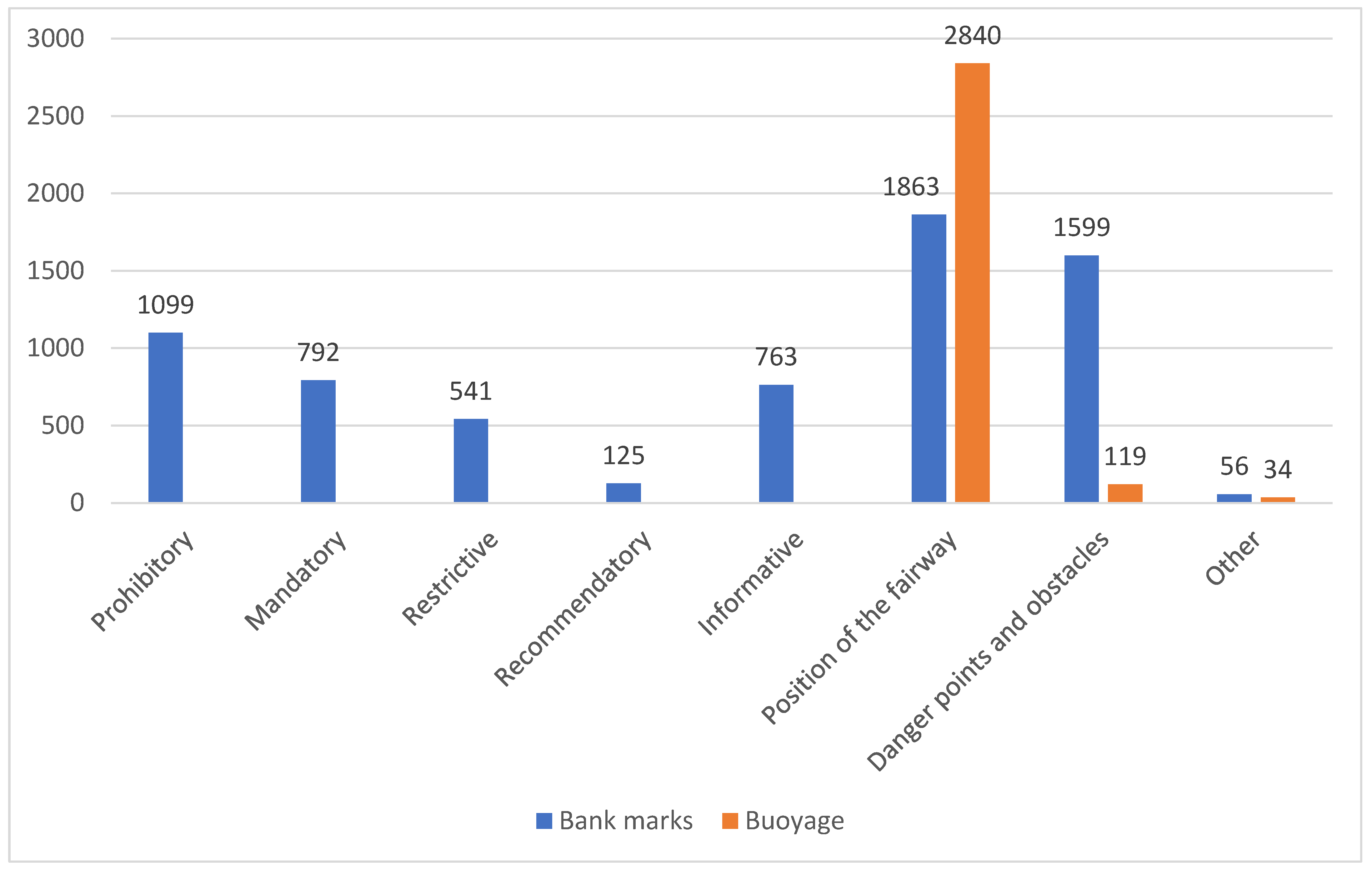
To ensure safe navigation, the State Water Holding Polish Waters (Państwowe Gospodarstwo Wodne Wody Polskie) has approximately 14,000 shore (permanent markings placed on the shore and on hydrotechnical structures) and floating signs (buoys located on the water) [41,42,43,44,45,46,47,48,49,50]. Shore signs dominate this list, as they form the basis of navigation signs on most sections of inland waterways in Poland. Among the approx. 10,000 signs of this type, navigational route signs predominate. On the other hand, approx. 4000 navigational signs are buoys, mainly for marking navigational route boundaries and dangerous areas, including navigational obstacles. To ensure safe navigation, almost 66% of shore signs (approx. 6800) and 75% of floating signs (approx. 3000) owned by the waterway administration are displayed (Figure 2), while the remaining signs are spare or worn out and require renovation. At the same time, it should be remembered that the above list only concerns navigation signs within the competence of the waterway administration, which is responsible for the navigable route and navigation infrastructure (locks and slipways) and related water structures and equipment. Point infrastructure and navigation signs intersecting with the waterway are installed by the owners [28].

2.2. Data

A comprehensive approach to the issue of navigation safety on inland waterways in Poland requires both a detailed analysis of the applicable legal provisions and field research, as well as the development of practical solutions aimed at improving the level of navigation safety. Therefore, the research methodology consisted of three complementary components:
(1)
Analysis of national and international legal frameworks;
(2)
Field observations and visibility tests of navigation marks;
(3)
Expert-based evaluation and development of design recommendations.
The combination of these approaches made it possible to compare regulatory frameworks, verify selected issues through field observations and formulate practical recommendations for the improvement of navigation marking systems.
The analysis of possibilities for improving navigation safety on inland waterways in Poland was based on the following legal acts:
The Act of 21 December 2000 on inland navigation—defines, among other things, the inland navigation administration authorities, their competences, conditions for navigation, safety requirements and rules for the classification and maintenance of inland waterways [28].
The Act of 20 July 2017—Water Law [51]—regulates ownership rights to surface waters, including inland waterways, and assigns responsibility for their maintenance.
The Regulation of the Minister of Infrastructure of 28 April 2003 on navigation regulations on inland waterways [52]—specifies, among other things, the method of marking navigable waterways, hydrotechnical structures and facilities, navigational obstacles, and the designs of navigational signs and signals.
The Regulation of the Minister of Transport and Maritime Economy of 10 September 1998 on technical conditions to be met by railway structures and their location [53]—contains guidelines for the marking of railway bridges crossing waterways.
In addition, local laws specifying detailed safety conditions for the movement and mooring of vessels on selected sections of waterways have been taken into account, including:
Order No. 1/2020 of the Director of the Inland Navigation Office in Szczecin of 18 February 2020 [54];
Order No. 1/2021 of the Director of the Inland Navigation Office in Wrocław of 25 May 2021 [55];
Order No. 1/2022 of the Director of the Inland Navigation Authority in Szczecin of 10 March 2022 [56];
Order No. 7/2024 of the Director of the Inland Navigation Office in Bydgoszcz of 26 June 2024 [57].
The analysis of international legislation took into account:
The European Code for Signs and Signals on Inland Waterways (SIGNI) [58]—Implemented by the European Economic Commission, this act contains recommendations on the installation and use of navigation signs on European inland waterways.
The European Code for Inland Waterways (CEVNI) [59]—Introduced by the United Nations Economic Commission for Europe, this document specifies, among other things, navigation signs for inland waterways.
At the same time, it was confirmed that Poland, as a member of the United Nations, has not ratified the above-mentioned international regulations and that they therefore do not constitute binding national law.
The analysis of international legislation was supplemented by a review of selected aspects of the shipping regulations in force in the Federal Republic of Germany (Binnenschifffahrtsstraßen-Ordnung) [60], which is particularly important due to the cross-border nature of the Oder Waterway and the Western Oder.
The objective of the regulatory analysis was to identify discrepancies between Polish legislation and international navigation standards, particularly in relation to the technical parameters of navigation signs, their visibility requirements and the marking of infrastructure intersecting waterways. In the first stage of the research, the regulations in force in Poland were reviewed in terms of navigation marking standards; then, solutions were proposed to increase the safety of inland waterway users. In the next stage, the differences between Polish regulations and those of the United Nations were identified.
An inventory of the navigation signs used on inland waterways in Poland was also carried out. For this purpose, a structured questionnaire survey was conducted among regional waterway management units responsible for the installation and maintenance of navigation signs, which made it possible to determine the quantity of signs broken down by type (land and floating). The questionnaire collected information on:
  • The number of shore navigation signs;
  • The number of floating navigation signs (buoys);
  • The operational status of signs (in use, reserve, or damaged);
  • The distribution of navigation signs across different waterway sections.
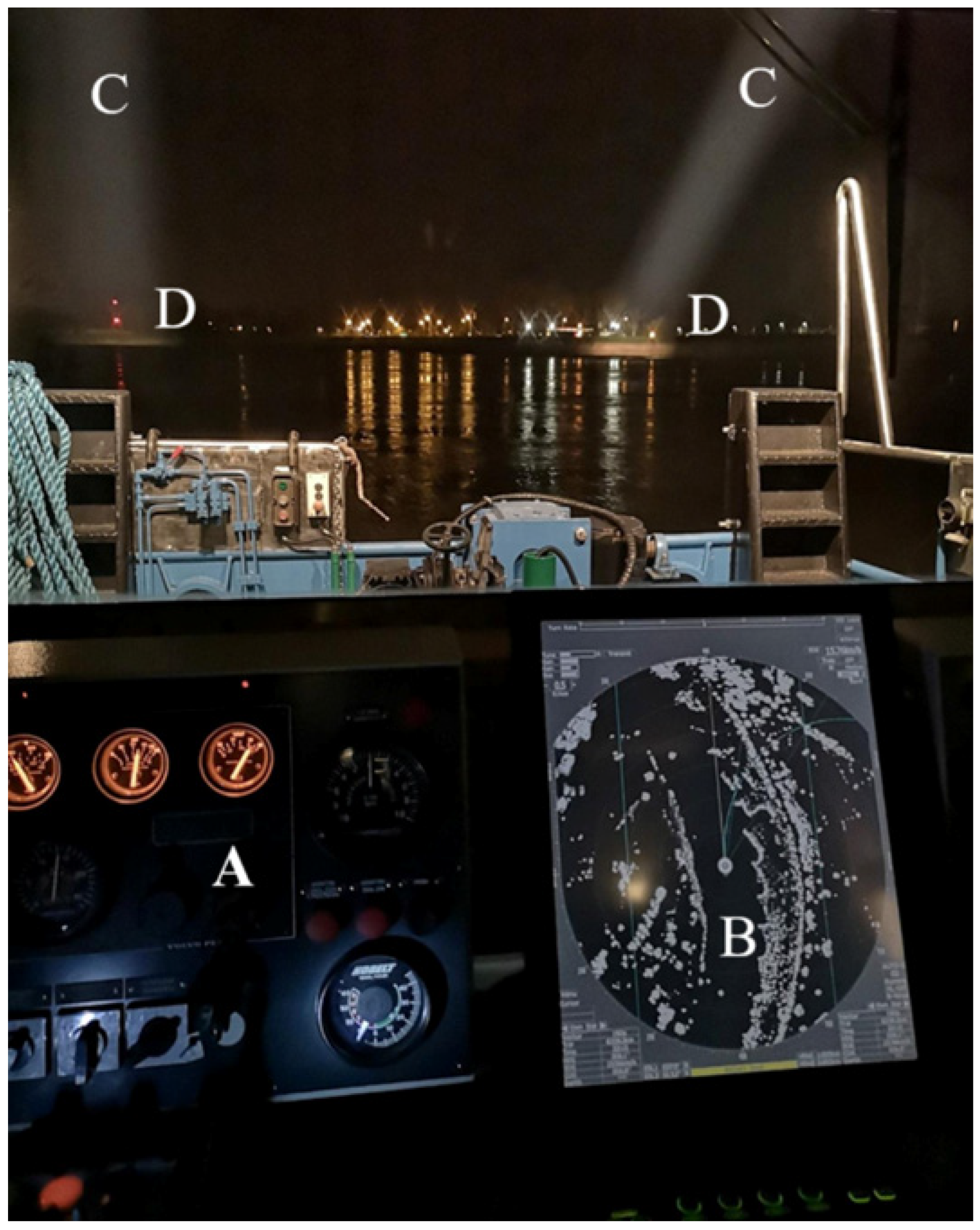
The next stage of the research involved field observations and visibility tests of navigation signs on selected inland waterways. These activities were informed by the review of national and international regulations, but field research was also necessary. The visibility of shore-based navigation signs was tested during regular checks of the readiness of waterways and navigation routes for night-time navigation on the border section of the Oder River, the Wrocław Water Junction, and the Vistula River in Kraków (Figure 3). These locations were deliberately selected to represent different functional types of inland waterways, including an international waterway section (the border section of the Oder River), an urban navigation node with complex infrastructure (the Wrocław Water Junction), and a regional waterway with significant tourism traffic (the Vistula River in Kraków). Although these sites do not represent the entire inland waterway network in Poland, they illustrate typical navigation marking challenges occurring on waterways with different operational characteristics.
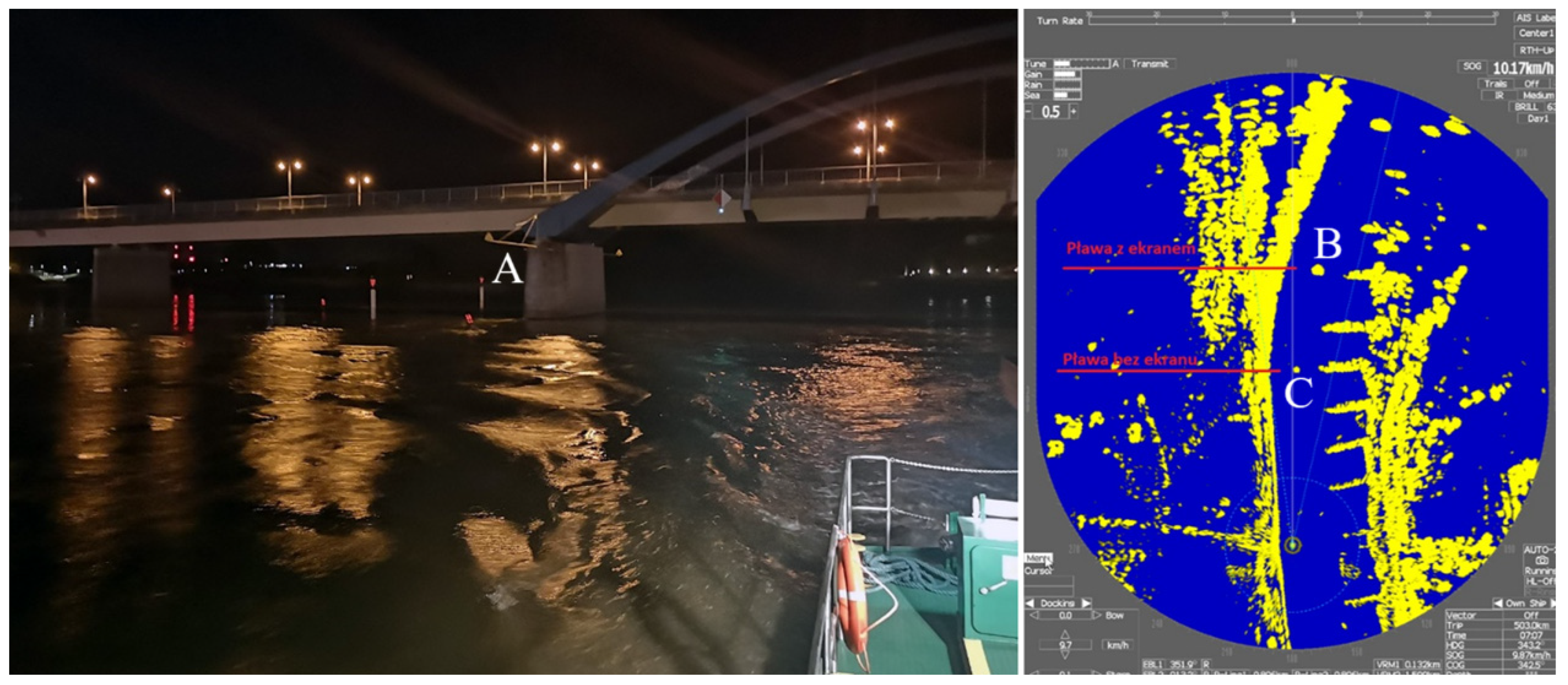
To assess the situation comprehensively, a comparative analysis was also carried out during the day-time. The fieldwork involved the use of vessels, a searchlight, binoculars with a rangefinder, and a lux metre. Radar displays were also an important element of the study (Figure 3), as the images obtained from them provided a clear basis for determining the position of a vessel [61], as well as the location of navigation signs and radar beacons on inland waterways. This work made it possible to determine the distances from which signs of various sizes and signs covered with different types of reflective film were visible, and to develop solutions for the marking of inland waterways for navigation at night and in conditions of limited visibility.
For the purpose of this study, visibility and recognisability were assessed using two operational criteria:
  • Detection distance—the distance at which a navigation sign could first be visually detected by the observer;
  • Recognition distance—the distance at which the observer could recognise the meaning of the sign.
Distances were estimated using range-finding binoculars and radar observations where applicable (Figure 3). The study covered all navigation signs located on the analysed sections of the navigable waterway, thus providing a comprehensive verification of navigation conditions during the day-time and night-time. Measurements on individual sections were conducted under comparable and favourable navigational conditions, understood here as excellent visibility, calm water, and low wind strength.
Based on the above research, several measures were proposed. These included introducing different size groups of signs into Polish legislation, preparing guidelines and proposed navigation marking plans for administrators of point infrastructure and the infrastructure intersecting waterways, and identifying navigation signs that are missing from Polish regulations in comparison with international standards. Another important element was the development, using design software, of conceptual designs for floating navigation signs representing individual types of signs. The study also found that information on the current vertical clearance under bridges is an element that increases inland waterway safety. Solutions used on bridges in Germany, the Netherlands, and Belgium were compared with Polish installations in terms of clearance gauges (inverted water level gauges). On this basis, and in cooperation with the Institute of Meteorology and Water Management, Poznań Branch [62], standardised designs recommended for use on inland waterways in Poland were developed.
It should be emphasised that the research was also based on expert knowledge and experience gained during inspections of navigable routes in 2021–2023, covering over 2500 km of waterways of international and regional importance. The expert evaluation involved specialists responsible for inland waterway management and navigation safety within the Polish waterway administration. These experts included waterway inspectors and navigation safety specialists with long-term professional experience in maintaining navigation markings and supervising navigable routes. This made it possible to verify the condition of navigational markings on the navigable routes and points and intersecting infrastructure. This was supplemented by observations and analysis of solutions used on selected waterways in Western Europe, from which good practices were adapted in this study.

3. Results

3.1. Analysis of Polish Regulations

An analysis of Polish legal acts and practical experience in work carried out to ensure safe navigation has identified several problematic issues concerning navigation marks:
(1)
Dimensions of navigational signs—Navigation regulations [52] specify the designs of navigational signs, but do not define their dimensions. As a result, there are discrepancies between different waterways in this respect. It has also been established that the internal regulations of the State Water Management Authority [63] specify uniform sizes for signs throughout the country, based on European standards contained in the SIGNI study. However, it should be remembered that this is not generally applicable law and appropriate legislative changes should be introduced to clarify the issue of navigation sign sizes throughout Poland. In practice, this regulatory gap leads to inconsistent sign dimensions across different waterways, which may reduce the uniformity and recognisability of navigation markings for waterway users.
(2)
Navigation marking of point infrastructure and infrastructure intersecting with inland waterways—The display of navigation signs in ports and of devices, structures and transmission lines intersecting with waterways is the responsibility of their owners [28], but not all entities follow the guidelines of the waterway administration, and missing or incorrect navigation signs are noticeable. Polish regulations do not include tools to enforce the mandatory use of appropriate signage. A good solution would be to oblige the owners of the designated facilities to agree with the waterway administration on navigation marking plans and their subsequent compliance. The lack of clear enforcement mechanisms results in the inconsistent marking of bridges, ports, pipelines and other infrastructure intersecting inland waterways, which may affect navigation safety and traffic organisation.
(3)
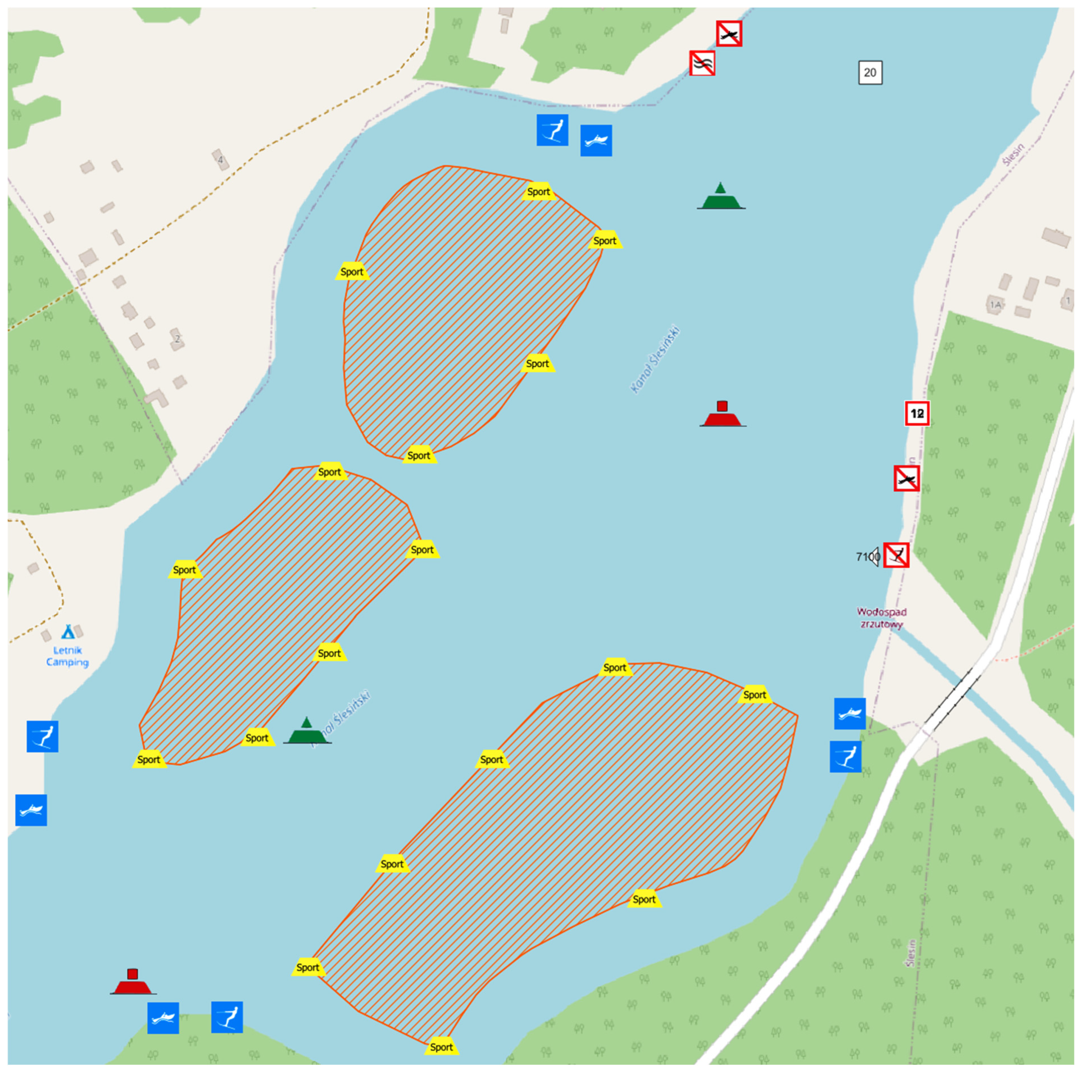
Areas for water skiing or similar activities—Water skiing or similar activities and the towing of aircraft behind inland waterway vessels are only permitted during daylight hours, in good visibility and in water areas designated by the director of the inland navigation authority, in consultation with the waterway administration, and marked with information signs such as E.17, E.18, E.19, E.20, E.21 and E.24 [52]. However, the regulations do not specify who is responsible for marking the designated zones, and this responsibility should be assigned to the entity that has an interest in designating such a zone and leases the relevant water area for this purpose.
(4)
Installation of clearance signs on bridge structures for navigation purposes—The regulation on the technical conditions to be met by railway structures and their location [53] recommends the installation of water level gauges. However, neither the Inland Navigation Act [28] nor the navigation regulations [52] specify the appearance of the gauge or where it should be located. At the same time, a review of the solutions used on inland waterways in Poland and Western Europe shows that there are no uniform designs. Therefore, it is recommended that an obligation be introduced to place clearance signs on bridge structures intersecting inland waterways, or in front of them with sufficient advance notice (e.g., 100–200 m). In this way, they would provide users of navigable routes with information about the current vertical clearance. This information may improve the situational awareness of vessel operators and reduce the risk of navigation errors related to the incorrect estimation of bridge clearance. A vessel’s master would then be able to verify, before reaching the bridge, whether the current navigation parameters are sufficient for the vessel to pass safely through the structure.
(5)
Incomplete guidelines for the marking of waterways where night navigation is permitted—Navigation regulations [52] only mention the need to cover navigation signs with reflective material. The distance from which the signs should be visible needs to be specified. In addition, in some places, lamps should be used to illuminate signs at night, and it may even be necessary to use additional navigation lamps if the regulations allow for interchangeable day and night markings. The lack of clearly defined visibility parameters may lead to differences in the practical implementation of night navigation marking systems on various inland waterways.
(6)
Incomplete guidelines for navigation in conditions of limited visibility—The navigation regulations [52] are not precise in terms of supplementing navigation signs with radar reflectors enabling the display of signs on the radar screen during navigation at night or in fog or heavy rain. Therefore, it should be clarified on which navigation signs radar reflectors are mandatory in order to allow radar navigation in a given area. The introduction of such requirements could contribute to greater consistency in navigation marking systems used in conditions of reduced visibility.
(7)
Differences in local regulations—Not all directors of inland waterway authorities have laid down guidelines in their local regulations [55,57] on the adaptation of waterways for night-time navigation and navigation in conditions of reduced visibility. Such provisions are extremely important for ensuring safe navigation in the circumstances indicated.
At the same time, it was found that the Water Law [51] does not address the issue of navigational markings.

3.2. Differences Between Polish Regulations and United Nations Regulations

A comparative analysis of national and international regulations (SIGNI [58] and CEVNI [59]) revealed a number of significant discrepancies that affect the safety and efficiency of inland navigation in Poland. In order to present the differences clearly, key issues have been summarised to enable readers to quickly identify areas requiring harmonisation and implementation in Polish legislation (Table 1).
This situation should primarily be attributed to the fact that international regulations have not been implemented into Polish law. It should be noted, however, that such action is not mandatory and each country is free to choose its own approach in this regard. Regardless of this, Polish navigation regulations [52] date back to 2003. Since then, numerous updates and technical clarifications concerning navigation marking systems have been introduced in international regulations such as SIGNI and CEVNI. As a result, significant differences exist between the detailed requirements of international regulations and the current Polish regulatory framework. These differences concern, in particular:
  • Technical parameters and dimensions of navigation signs;
  • Requirements for lighting and visibility distances;
  • The use of radar reflectors and modern navigation technologies;
  • The introduction of new types of navigation signs responding to emerging operational needs.
Therefore, international experience should be taken into account, at least in part, when amending national regulations. Such harmonisation does not necessarily require the full legal adoption of international conventions, but may involve the gradual adaptation of selected technical standards that improve the consistency and recognisability of navigation marking systems.

3.3. Guidelines for Navigational Marking in Poland

Based on the analysis of Polish legal acts, the comparison with international regulations and field observations of navigation markings, a set of recommendations for improving navigation marking systems on inland waterways in Poland has been developed. The proposed solutions address both regulatory gaps and practical problems observed during inspections of navigable waterways.
The recommendations presented below concern several key aspects of navigation marking systems, including the dimensions of navigation signs, the marking of infrastructure intersecting waterways, the introduction of missing signs, and the improvement of marking systems used for night navigation and navigation in conditions of limited visibility.

3.3.1. Introduction of Standards for the Size of Navigation Signs

In accordance with SIGNI standards [58], a single size of shore navigation signs is used on European inland waterways. These standards specify detailed dimensions and proportions, which facilitate the recognition and standardisation of signs. However, the study has shown that this solution can be adapted to local conditions, which include not only waterways of international importance but also regional waterways with lower navigability, often used exclusively for water tourism.
The parameters of navigation signs indicated in SIGNI [58] are mostly based on sign dimensions of 1.0 m × 1.0 m and 1.2 m × 1.0 m. The use of such signs significantly improves the consistency and recognisability of navigation marking on inland waterways. When appropriate reflective foil is used, this type of marking is highly visible to waterway users. The use of uniform sign dimensions also means that waterway users have no doubt as to which regulation indicated on the sign applies to a given section of the waterway. The same standard dimensions for sign boards also reduce the risk that vessel operators will overlook orders, prohibitions, or other information when smaller signs are placed between boards compliant with SIGNI.
Notwithstanding the above, experience gained during inspections and consultations with waterway administration staff responsible for displaying navigation signs also indicates several disadvantages of using uniform sign sizes:
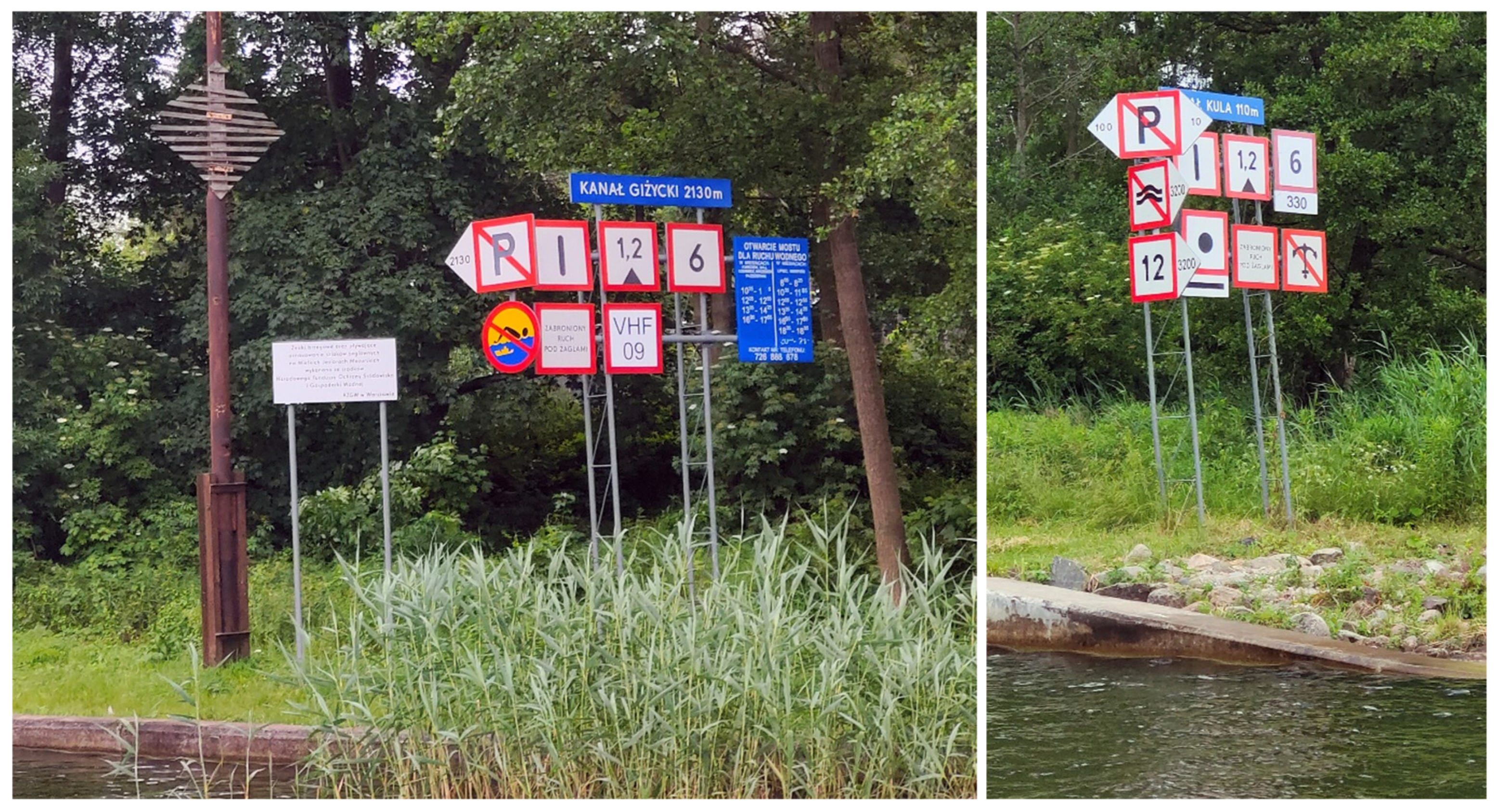
SIGNI-compliant navigation signs, when displayed in large numbers next to each other, may interfere with perception, in particular when important navigation signs (e.g., prohibition or mandatory signs) are located near signs of lesser importance (e.g., information signs)—with the current sizes, the legibility of the information presented is already impaired (Figure 4).
Higher production costs.
Higher repair costs due to the use of more consumables.
The larger surface area of the navigation sign increases its susceptibility to damage caused by strong winds.
Due to potential difficulties in introducing uniform sizes for shore marks, but also taking into account the specific nature of navigable waterways in Poland, an alternative method of navigational marking has been developed. It involves adjusting the size of the signs depending on the inland waterway class and, at the same time, adjusting their visibility to ensure safe navigation. A similar solution is used in road engineering, where five groups of sign sizes have been established, mainly based on the category of the road: warning, prohibition, mandatory, information, and direction and location [64,65].
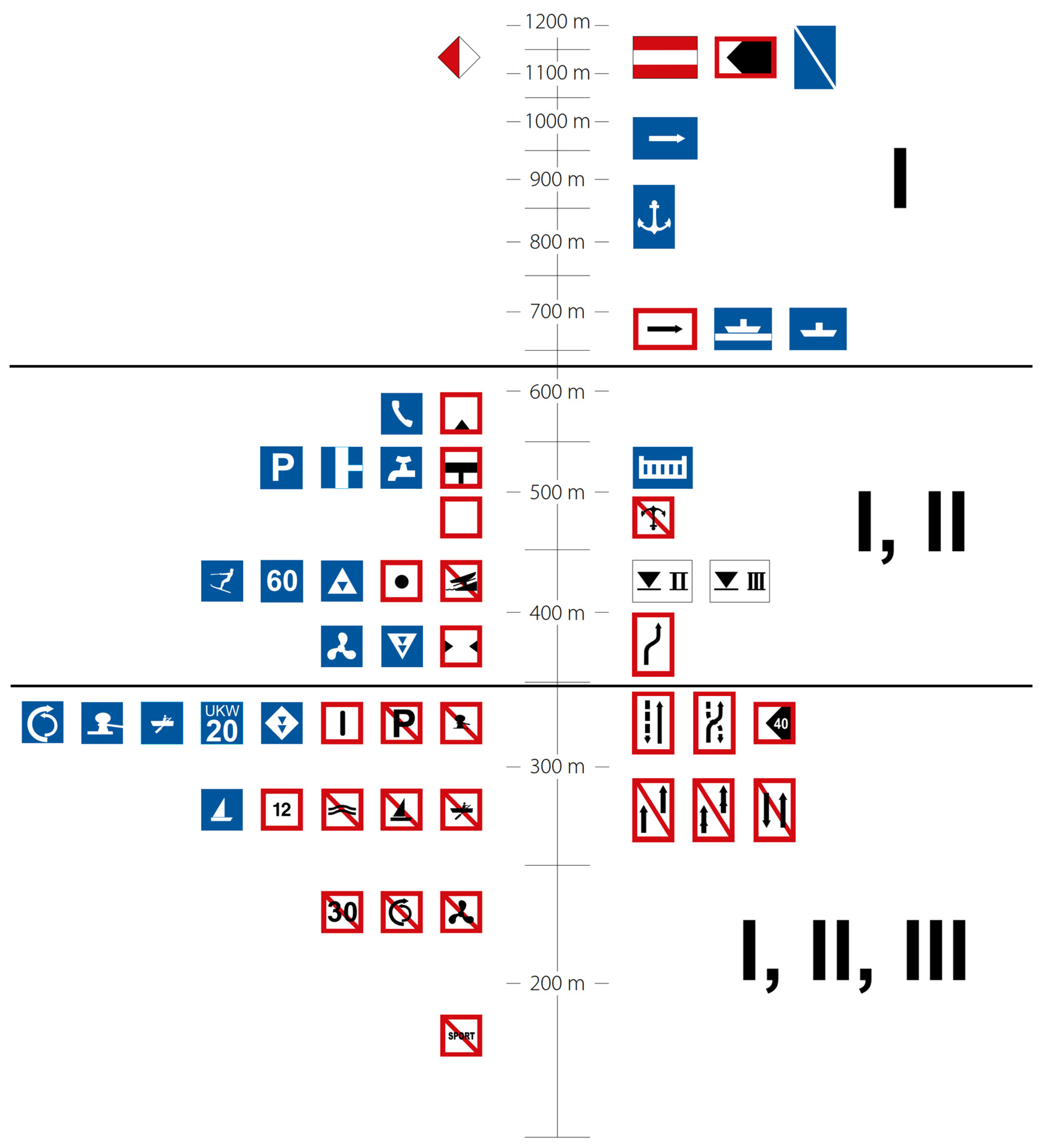
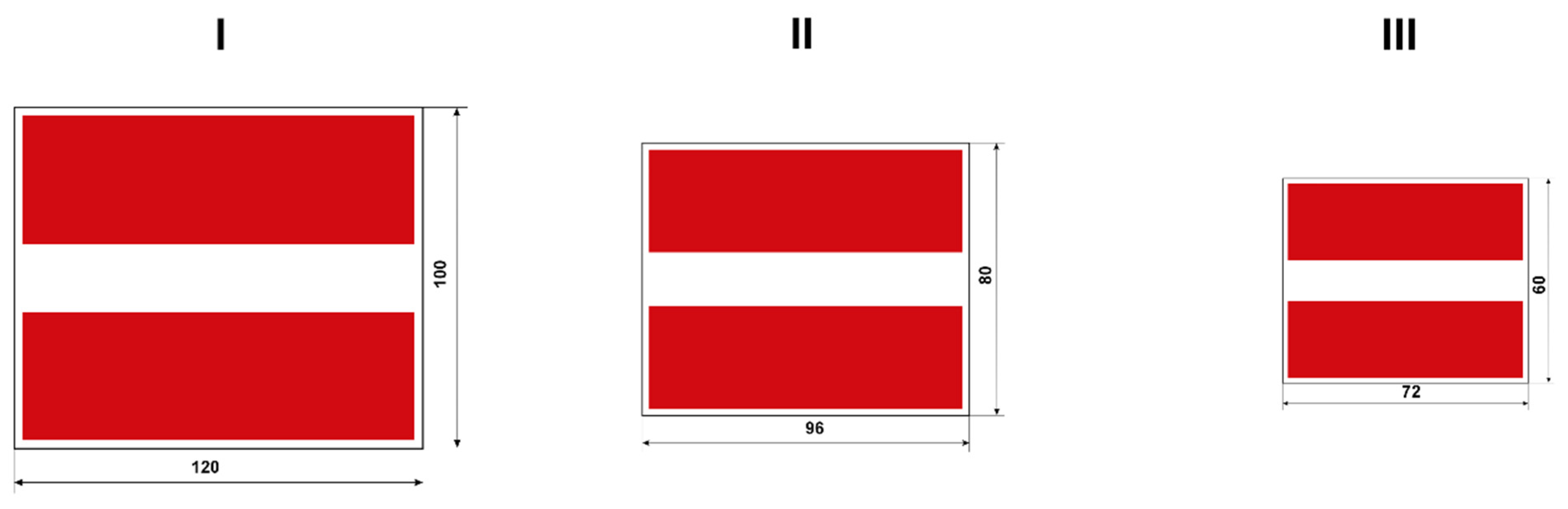
Based on the research conducted, it was proposed to use three groups of sizes for shore navigation signs (Figure 5), based on the proportions specified in SIGNI:
Group I—signage corresponding to 100% of the size of SIGNI signs;
Group II—signage corresponding to 80% of the size of SIGNI signs (with navigation symbols reduced proportionally to 80% of the original size);
Group III—signage corresponding to 60% of the size of SIGNI signs (with navigation symbols reduced proportionally to 60% of the original size).
The proposed proportions of 100%, 80% and 60% were adopted as practical scaling variants derived from the base dimensions specified in SIGNI. Their purpose is to preserve the proportions and recognisability of sign symbols while allowing the dimensions of sign boards to be adapted to waterways with different operational characteristics, traffic intensity and installation constraints.
In particular, the largest size group is recommended for waterways of higher importance and longer viewing distances, whereas the reduced groups may be applied on regional waterways and in locations where the installation of full-size signs would create excessive visual clutter or technical difficulties. The proposed thresholds therefore result from operational experience, field observations and the need to maintain proportional symbol geometry rather than from arbitrary dimensional reduction.
When determining signs from groups II and III (Figure 5), it is not necessary to introduce all schemes in Polish regulations relating to each type of marking. It is sufficient to add the appropriate notation indicating multipliers of 0.8 and 0.6 of the base value of the reference signs from group I.
The analyses carried out have shown the possibility of using different sizes of navigation signs depending on:
Waterway class—In this solution, the principle of displaying navigation signs according to the waterway class has been adopted, assuming the need to ensure standards compliant with SIGNI, in particular on waterways constituting supra-regional connections. Therefore, the following principles are proposed:
Waterways of international importance (class IV-Vb)—use of signs from group I;
Waterways of regional importance in classes II and III—use of signs from groups I and II;
Waterways of regional importance in classes Ia and Ib—use of signs from groups II and III.
Type of signs—The proposed variant takes into account the importance of a given group of signs for ensuring safe navigation. On this basis, the following have been adopted:
Prohibition signs—use of signs from group I;
Mandatory signs—use of signs from group I;
Restriction signs—use of signs from group I and group II;
Recommendation signs—use of signs from groups I and II;
Marking of dangerous places—use of signs from groups I and II;
Information signs—use of signs from groups I, II and III;
Auxiliary signs—use of signs from groups I, II and III;
Other signs—use of signs from groups I, II and III.
Visibility for the vessel’s operator—SIGNI includes provisions specifying the distance from which signs should be visible to waterway users. The application of this criterion may also be crucial for the display of navigation signs, and therefore the possibility of displaying signs from individual groups has been proposed (Figure 6).
It should be remembered that navigational safety plays a key role in the use of appropriate navigation signs. In addition to the examples discussed above, other conditions may arise depending on the specific water area and inland waterway. For example, on some water areas night navigation is permitted, and in such situations navigation signs smaller than those specified in SIGNI, i.e., those outside group I (Figure 6), should be excluded because reduced-size signs may not provide a sufficient recognition distance under such conditions.

3.3.2. Obligation of Owners of Point Infrastructure and Infrastructure Intersecting with Inland Waterways to Agree with the Waterway Administration on Navigation Marking Plans and Their Subsequent Compliance

Guidelines have been prepared that administrators of individual facilities should follow when planning and installing navigation markings:
Bridges and footbridges (Figure 7)—Each span must be marked as appropriate to the situation: if it is impassable, closed, or traffic is permitted only from the opposite direction, it must be marked with sign A.1; each navigable span must be marked with signs A.10, D.1a or D.1b, and C.2 (sign A.10 may be replaced by sign D.2 only in places where the depths outside the channel limits also correspond to the parameters of the waterway and there are no underwater obstacles, and such a change must be approved by the waterway administration); and if the navigable channel under the span is narrower than that specified for the inland waterway class, the span must also be marked with sign C.3. The signs must not protrude beyond the bridge clearance and, on inland waterways adapted for night navigation, they must also be illuminated at night and preferably equipped with a radar reflector.
Power lines (Figure 7)—Each power line should be marked with sign E.2, supplemented in the lower right corner with a value indicating the height of the overhead line above the highest navigable water level (determined on the warmest days, owing to the dependence of line length on weather conditions).
Ferry crossings—Each crossing should be marked as follows: a moored ferry with sign E.4a and a freely moving ferry with sign E.4b; in addition, each ferry should be marked with signs B.7 and B.8.
Pipelines and underwater lines—These should be marked with sign A.6b, which, unless supplemented with additional signs in the form of an arrow indicating the direction and distance to which it applies, must be cancelled by sign E.11.
Marking of port and harbour entrances (Figure 7)—For this purpose, the following should be used: sign IV.A.1 on the left and sign IV.A.2 on the right, and on inland waterways suitable for night navigation, these signs should additionally be equipped with radar reflectors and illuminated, i.e., sign IV.A.1 with a red flashing light of any rhythm and sign IV.A.2 with a green flashing light of any rhythm.
The introduction of a formal requirement to agree upon navigation marking plans with the waterway administration would make it possible to standardise the marking of infrastructure intersecting waterways and reduce the occurrence of incomplete or inconsistent marking solutions.

3.3.3. Clarification of the Provisions Concerning Water Skiing or Similar Equipment

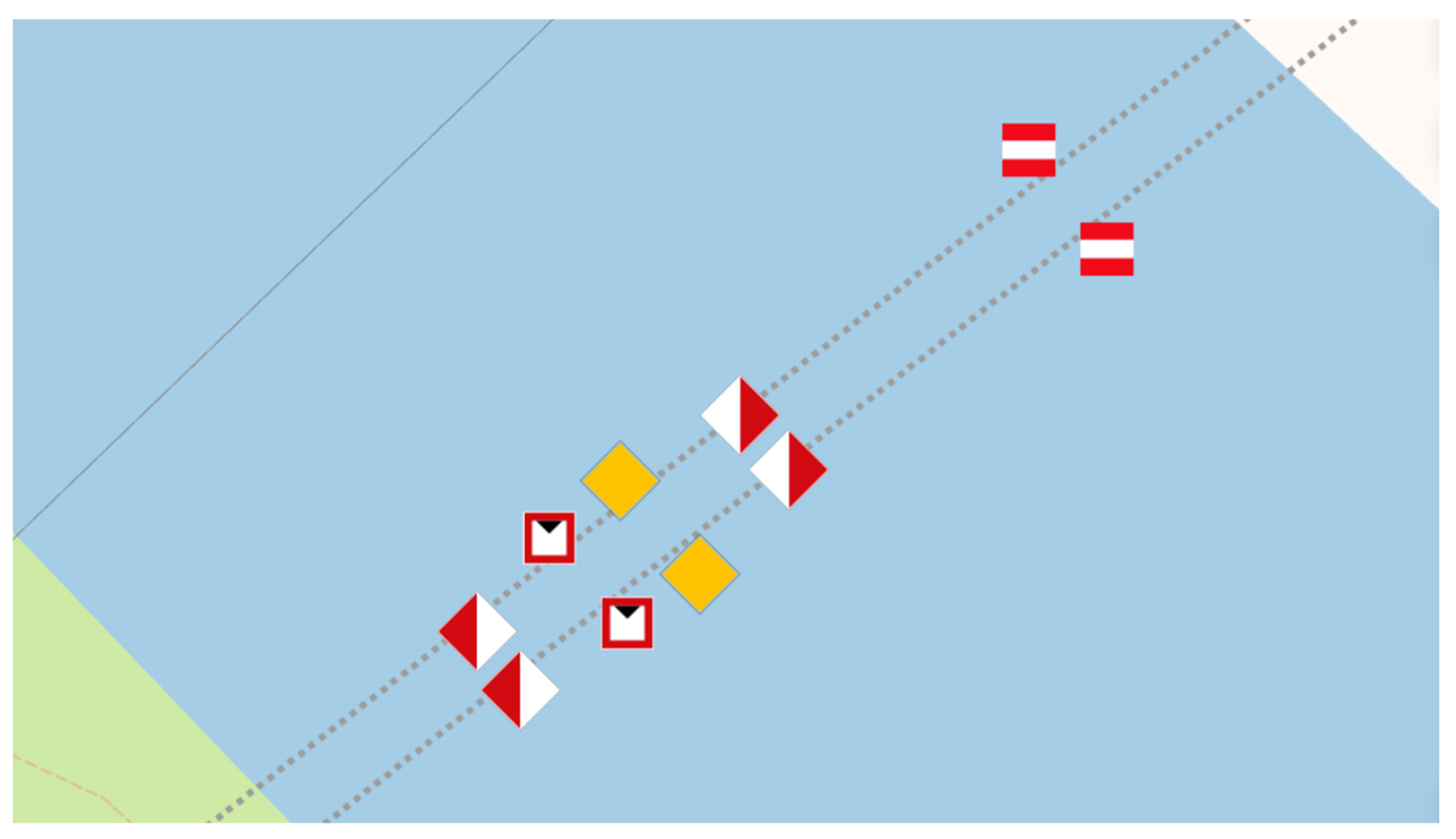
It is proposed to add to the navigation regulations [52] a provision specifying that responsibility for marking areas designated for water skiing or similar activities lies with the entity that leases the water area and is responsible for ensuring safety therein. At the same time, the location of such a place and the method of marking it with information signs E.17 (Figure 8) should be approved by the waterway administration.

3.3.4. Installation of Clearance Markers on Bridge Structures for Navigation Purposes

In view of the identified need to improve safety in the vicinity of bridge structures, which constitute navigation obstacles, it has been proposed that provisions be introduced into the navigation regulations [52] concerning the use of clearance signs on the piers of bridges crossing navigable waterways (in both directions, with a recommendation to place them on the right-hand side). This would make it possible to read the current vertical clearance and improve the situational awareness of vessel operators approaching the structure. It is worth noting that neither the Polish navigation regulations [52] nor the international regulations SIGNI [58] and CEVNI [59] contain any official guidelines on the use of clearance signs. Solutions of this type are implemented locally, based on the practice and experience of waterway managers rather than on formal regulations. The introduction of clear standards in this area could contribute to the harmonisation of the information system for waterway users, improve navigational consistency, and reduce the risk of misinterpreting bridge-clearance conditions.
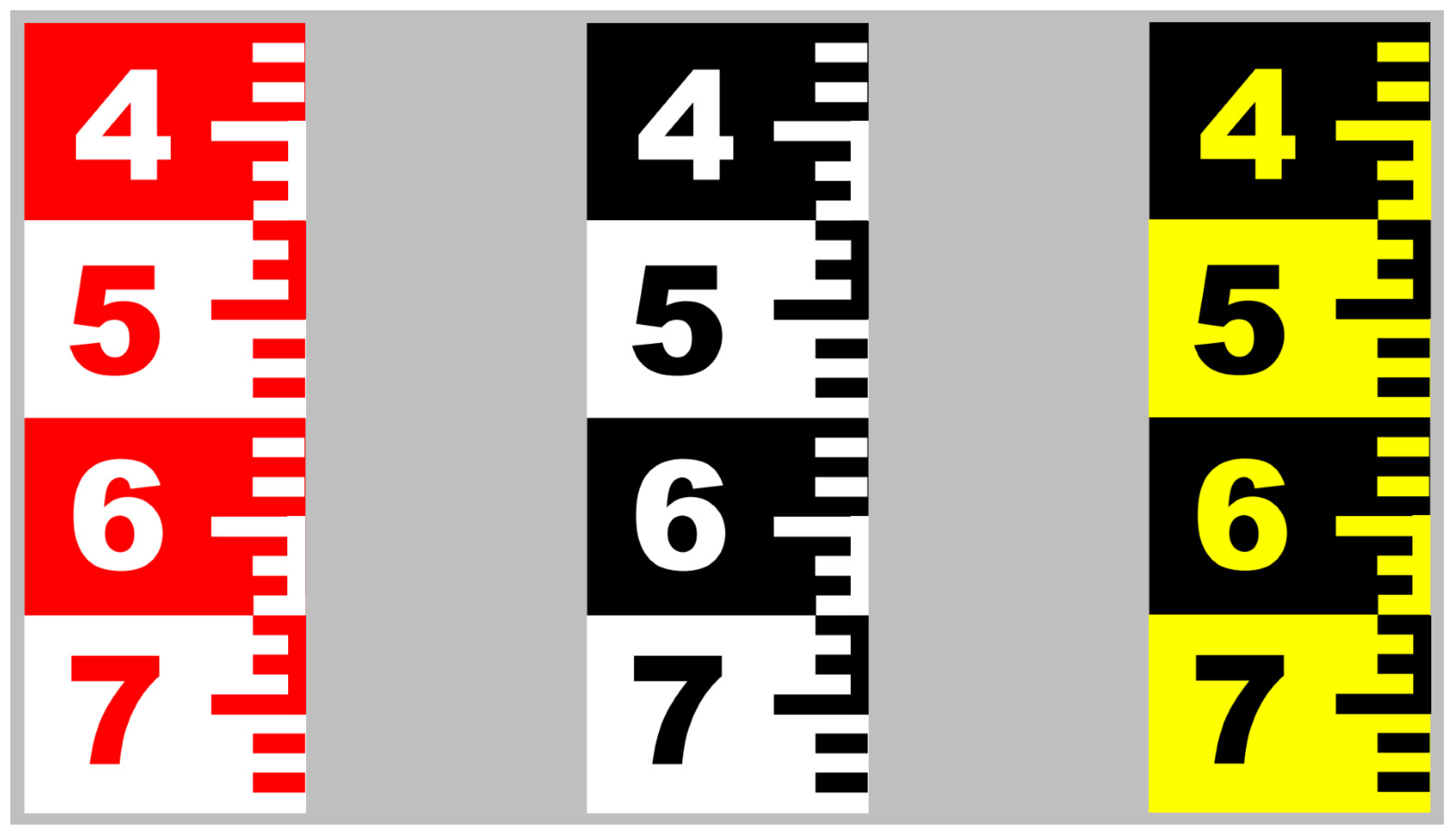
It is therefore reasonable to introduce definitions of clearance signs in Polish and international regulations, detailed requirements for their design, colour and scale, as well as standardisation of their location on both sides of the bridge in a place visible to the crew. This should also include an obligation for the owner of a structure crossing a waterway to regularly inspect and maintain the equipment. At the same time, a template for a device to be installed on bridge piers or, in exceptional cases, in front of the structure has been developed with the following parameters: the size of the board with the number is 1.5 m × 1.0 m and, additionally, the board with the scale is 0.5 m × 1.0 m (scale every 10 cm with a clear marking of half a metre) (Figure 9).
At the same time, it should be noted that a more advantageous solution would undoubtedly be the use of sensors on bridges and associated automatic dynamic (digital) signs displaying the current clearance, as found on selected inland waterways in Western Europe. Therefore, the pilot implementation of such a solution on selected sections should be considered, especially on bridges with clearance lower than that required by regulations on inland waterways used for tourism. However, this method is much more expensive, both at the implementation stage and during subsequent operation, and is not required given the current volume of shipping traffic in Poland. National regulations, unlike SIGNI, do not regulate the use of dynamic signs.

3.3.5. Marking of Lake Exits

The special marking of lake route exits used in Poland (mainly on water bodies such as Lake Dąbie, the Great Masurian Lakes System and the Elbląg Canal) is not provided for in SIGNI and CEVNI. Therefore, it is recommended to use standard signs IV.A.1 and IV.A.2. This will harmonise the marking of lake exits with the European system, limiting the use of special signs. The proposed system will be consistent, and all locations should be marked in the same way, as there is no difference between an entrance to a port, a side canal or a branch on a lake.

3.3.6. Addition of Missing Signs

Polish navigation regulations do not include a prohibition sign for motorised vessels. In SIGNI [58] and German regulations [60], there is a sign, A.1.1, which clearly prohibits motorised vessels from entering. Therefore, it is recommended that sign A.1.1 be introduced into national regulations, as this would facilitate traffic management in recreational waters.
The situation is similar with the new navigation mark for wreck floats. SIGNI has introduced a sign for a newly discovered and marked hazard—a buoy with yellow and blue stripes and a yellow cross at the top. It was developed on the basis of practices used in maritime areas and is compatible with the IALA system [67]. The temporary wreck buoy has been designed as an additional navigation mark for use in both visual and radar navigation. It should be displayed as close to the navigational obstacle as possible. It is recommended that such marking be introduced into Polish navigation regulations.

3.3.7. Implementation of Solutions for the Marking of Inland Waterways for Night-Time Navigation and in Conditions of Reduced Visibility

In accordance with the proposed introduction of standards for the size of navigation signs suitable for night-time navigation and in conditions of limited visibility, it is essential to use shore-based navigation signs with the parameters specified in SIGNI, i.e., those classified in group I (Figure 6). Navigation signs should be covered with reflective film, and tests have shown that third-generation film has the most favourable properties in this respect (Figure 10).
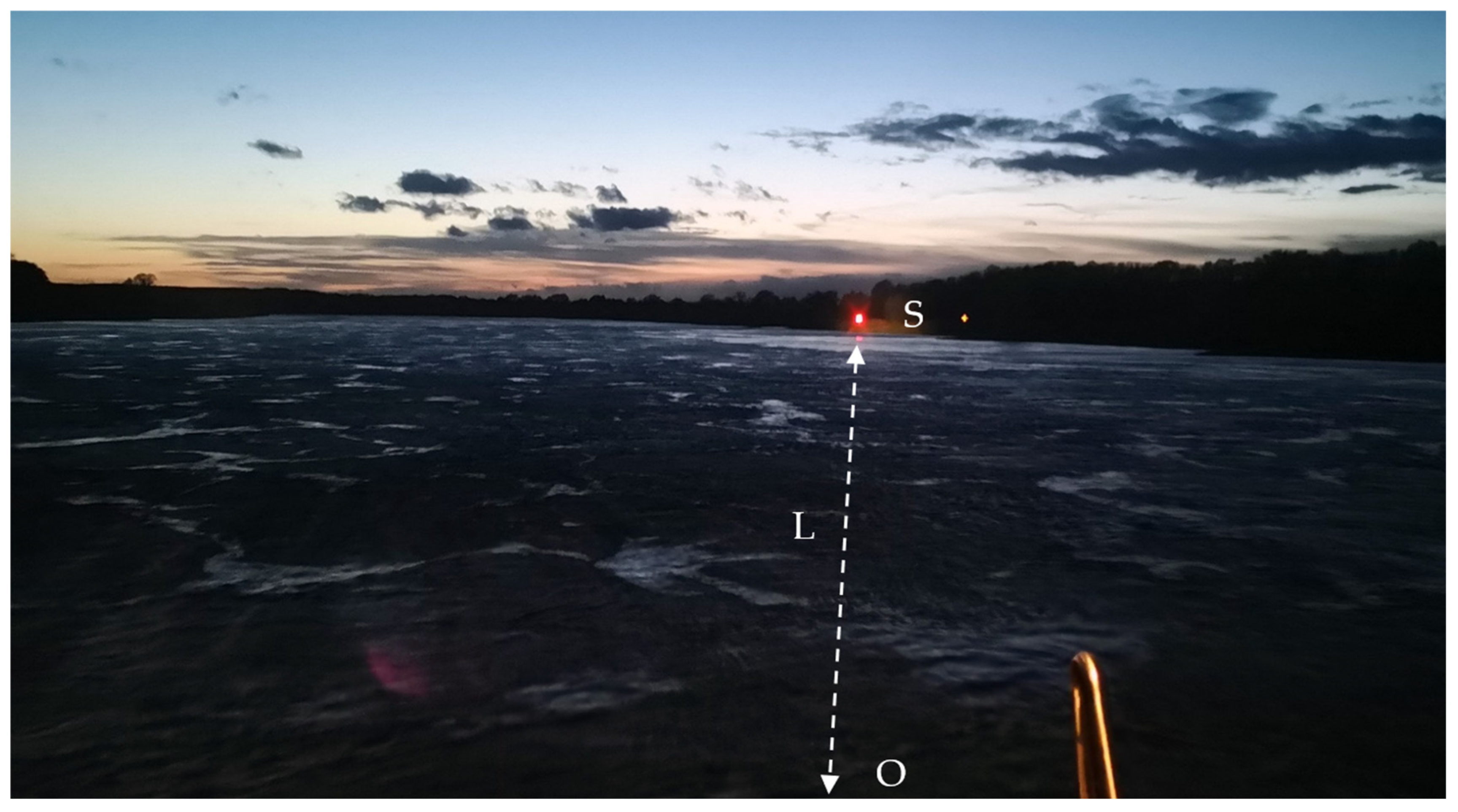
Observations (Figure 11) show that navigation markings covered with third-generation reflective film are visible from a distance of up to 2–3 km. In contrast, navigation signs covered with second-generation reflective film can be seen from a distance of 1.2 km, and those covered with first-generation film only from approximately 0.5 km. Of course, a person without optical instruments is unable to read the information on the sign but can see the light reflected from these signs and is therefore aware of the direction of travel and the need to familiarise themselves with the signage. Only when approaching the sign at a distance of approximately 0.8–0.3 km, depending on individual abilities, are they able to read the information on the sign without the use of additional devices. Field observations therefore indicate that higher classes of reflective film may substantially improve the detection distance of navigation signs during night navigation.
In addition, point infrastructure and infrastructure intersecting with inland waterways must be additionally illuminated at night. On waterways intensively used at night, especially by passenger ship operators and individual users, it is also recommended that buoys with autonomous rhythmic white lights be used at branches, and that appropriately rhythmic red lights be used on the right-hand side of the route and rhythmic green lights on the left-hand side at entrances to ports and harbours. In this regard, Polish regulations should be supplemented with detailed light characteristics, which would improve the consistency of night-time marking and harmonise national regulations with international standards. At present, the lighting of signs is treated as optional and is described imprecisely, which may lead to poor visibility at night or in conditions of limited visibility. In addition, navigation signs, particularly on bridges, at port entrances, and on floating signs on navigable waterways, should be equipped with radar reflectors (Figure 11), which improve radar conspicuity and facilitate navigation in reduced-visibility conditions.
At the same time, it is recommended that appropriate regulations be introduced into local law to clarify the rules for navigation at night and in conditions of limited visibility.

3.3.8. Development of Floating Navigation Mark Designs

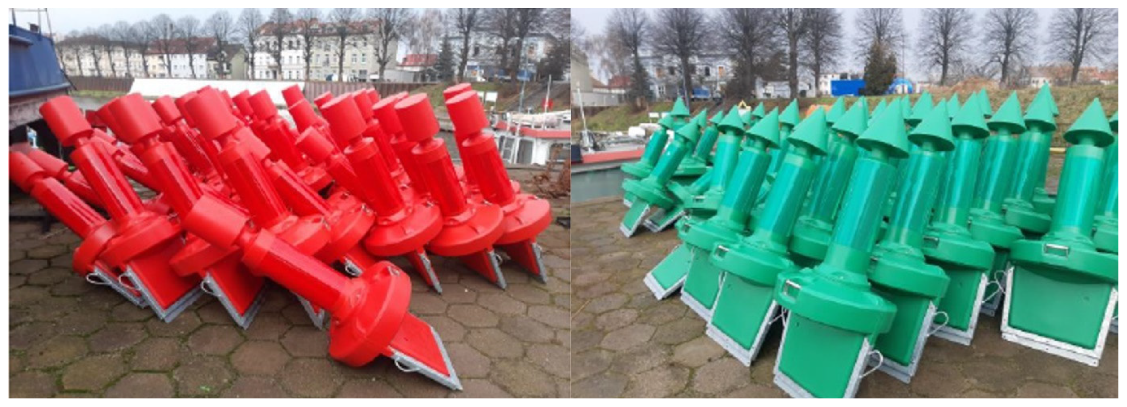
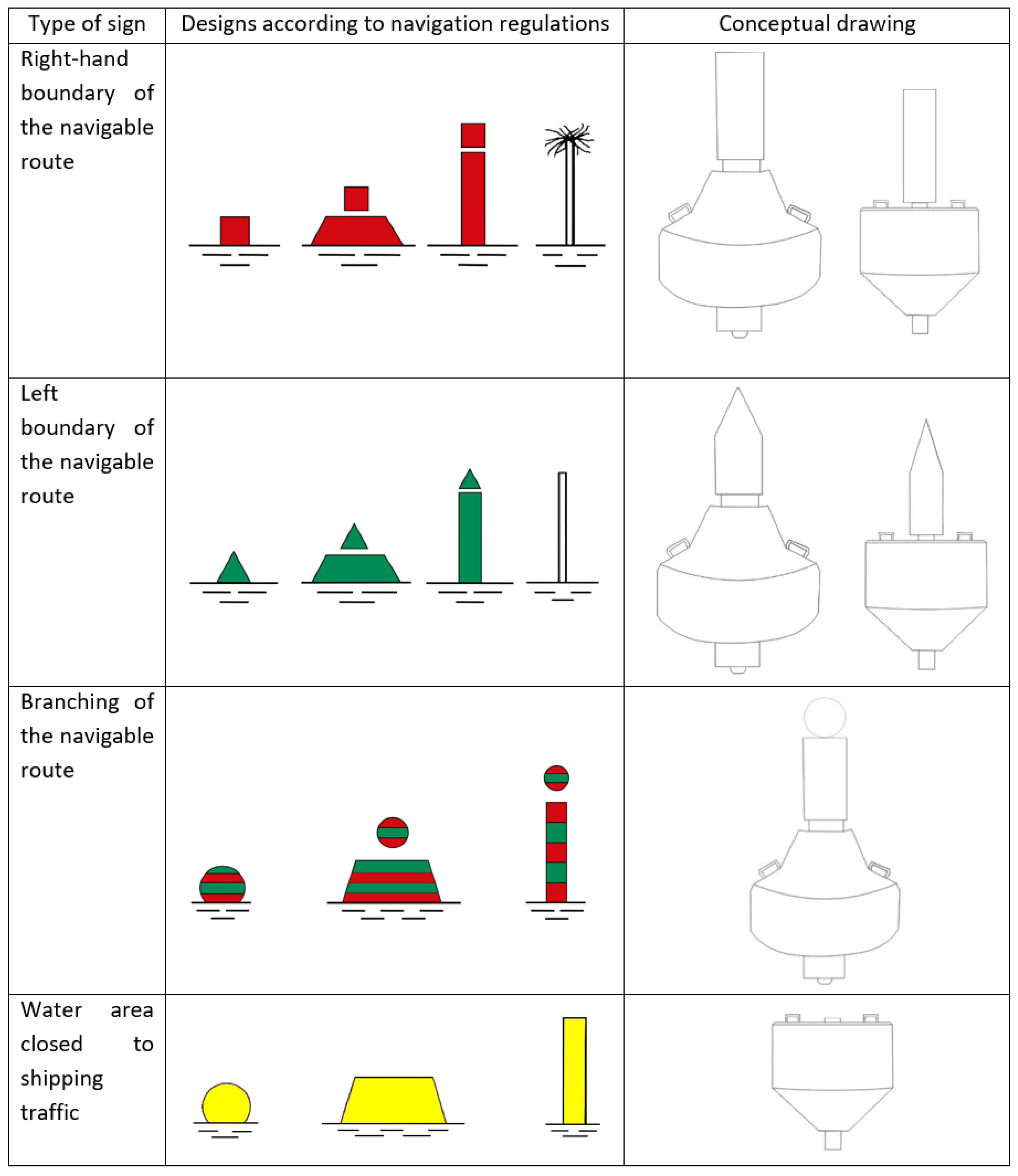
Due to the lack of clear parameters for floating navigation signs in shipping regulations and SIGNI, and additionally due to the different designs in the first of the aforementioned legal acts, there is a need to clarify this issue.
Floating navigation signs adapted for night-time navigation and in conditions of limited visibility are being introduced on many inland waterways in Poland (Figure 3, Figure 10, Figure 11 and Figure 12). However, due to the experience gained so far with their operation and the need to standardise their parameters, conceptual designs for floating navigation signs have been developed (Figure 13).
When developing guidelines for buoys to be used in the future on Polish and other countries’ inland waters, the following groups were established (similarly to land-based signs):
Marking of main shipping lanes—use of larger sizes;
Marking of secondary navigable routes and closed waters—use of smaller sizes;
Marking of hydrotechnical structures and branches—use of larger sizes (Figure 13).
Therefore, larger buoys should be used for main navigable routes than for side navigable routes or hydrotechnical structures. Their technical parameters are the subject of further work, and at this stage, prototypes have been prepared and tested in real-world conditions.
However, it should be emphasised that the proposed solutions should be tested using pilot buoys in order to assess their structural correctness and effective functioning in real conditions. In this respect, the authors plan to carry out further research leading to the implementation of the described buoys.
It should also be noted that the above recommendations are based on a comparison of national and international regulations (3.3.1, 3.3.2, 3.3.5, 3.3.6, and 3.3.7), field observations (3.3.1, 3.3.3, 3.3.4, 3.3.7, and 3.3.8), and design recommendations (3.3.1, 3.3.2, 3.3.3, 3.3.4, 3.3.5, 3.3.6, 3.3.7, and 3.3.8). Most of them are the result of a convergence of several factors.

4. Discussion

This study made it possible to compare national and international regulations concerning navigation marking. The navigation regulations applied in Poland [52] are, in several respects, very general and relatively old (having been in force for more than two decades). They have not yet been updated, whereas in Europe many modifications and clarifications to the original provisions have already been introduced in SIGNI [58] and CEVNI [59]. As a result, there are differences between the detailed regulations and the navigation signs used, the most significant of which are listed in this study. Some of the main problems are the dimensions of navigation signs, unclear provisions concerning navigation at night and in conditions of limited visibility, the absence of clearance signs, and the lack of standard designs for floating signs. In line with international practice, the proposed changes to navigation marking systems may improve the recognisability and consistency of navigation signs and contribute to more coherent marking practices on inland waterways. Such improvements may support safer navigation conditions [68], particularly during night navigation or in reduced visibility.
After analysing both Polish and European legal acts and taking into account expert experience, it should be concluded that there are two standards for the demarcation and marking of inland waterways in Europe, with the Elbe River in eastern Germany forming the boundary between them. On the Elbe itself and to the east of it, there are signs in the form of frames and crosses that regulate the course of the shipping route and comply with the regulations in force in this area [60]. To the west of the Elbe, these signs have their equivalents in the form of boards. These differences are partly the result of the historical development of navigation systems and institutional frameworks in different parts of Europe. Western European waterways, particularly those associated with the Rhine basin, have developed highly standardised marking systems coordinated by international river commissions, while waterways in Central and Eastern Europe often rely more strongly on national regulatory frameworks. SIGNI also includes sign A.1.1, which is also provided for in the inland waterway regulations of the Federal Republic of Germany. In Western European countries, clearance markers are also used for shipping purposes (e.g., in the Netherlands). At the same time, on inland waterways in Western Europe, various solutions have been introduced to increase user safety, together with numerous improvements resulting from technological advances in navigation signage, such as navigation lighting using photovoltaics, more advanced solutions in the form of sensors and active signs on bridges displaying the current clearance above the highest navigable water level, radar reflectors, reflective materials, and high-visibility colours for signs.
It should be noted that Poland has not ratified the international CEVNI and SIGNI regulations, which means that they are not binding law. Therefore, consideration should be given to taking steps to implement these regulations or—when introducing changes to national legislation and recommended updates to navigation regulations—taking into account European and global standards for navigation signs and user safety, which serve as a kind of roadmap for other developed countries. Some of the provisions have been introduced by the waterway administration in its internal regulations [63], on the basis of which uniform standards for the navigational marking of navigable waterways and point and intersecting infrastructure (e.g., specific dimensions and precise appearance of pictograms) should be applied, in accordance with the regulations in force in Poland.
However, this is not a generally binding act and is therefore not mandatory for all entities responsible for issuing navigation signs. Despite this, the highest standards of navigation marking have been introduced, inter alia, on sections of the Oder (including the border section of the Oder, the Szczecin Waterway Junction [69], the Wrocław Waterway Junction [70]) and the Vistula (Kraków [71] and Warsaw [72]), which have thus been adapted for night-time navigation. New navigation signs are also found on shipping routes used for tourist purposes, including the heavily used Augustów [73] and Ślesiński [74] canals.
Unfortunately, this type of navigation marking is very expensive, which significantly limits its comprehensive replacement and use on all inland waterways in Poland (Figure 1). Analyses show that a buoy with lighting and a radar reflector is, on average, approximately EUR 300 more expensive than a buoy not adapted for night navigation. There has also been a systematic increase in the prices of shore markers in recent years, while prices for floating markers have remained relatively stable. Therefore, it is recommended that this type of marking be introduced first on sections with the highest shipping traffic, in particular in large cities and on the Great Masurian Lakes route. From a governance perspective, the implementation of the proposed solutions would involve several stakeholders, including waterway administrations, infrastructure owners (e.g., bridge operators, port authorities, and utility companies), as well as vessel operators and tourism enterprises. The introduction of clearer regulations concerning navigation marking plans for infrastructure intersecting waterways may therefore require institutional coordination and administrative enforcement mechanisms to ensure compliance among different stakeholders. At the same time, it should be remembered that for each party responsible for installing navigation marks on its facilities, and in the case of the waterway administration also on the navigable routes, the introduction of new guidelines regarding navigation marks would involve additional costs. Furthermore, in the case of bridges and other infrastructure crossing waterways, these proposals may be used in the development of a reliable bridge-collision warning system for inland vessel navigation [75]. This is important because, for example, in Serbia most shipping accidents occurred near Belgrade, at the confluence of the Sava and Danube rivers, and near bridges—places characterised by complex navigation conditions [25].
During the study, it was also found that shore markings in the form of frames and crosses should be maintained, due to the costs already incurred for the purchase and maintenance of existing signs, and supplemented with floating markings on the main rivers in Poland. Furthermore, the authors are aware of the legislative difficulties involved in introducing new solutions and the related requirements for navigational signs in order to increase safety on navigable waterways. In 2021, amendments to the Inland Navigation Act [28] were under consideration in Poland, which were intended, among other things, to introduce provisions concerning coordination with the waterway administration on navigation marking plans for point infrastructure and infrastructure intersecting waterways [76]. The guidelines prepared would fit well within the legal provisions under consideration and would greatly facilitate the work of the owners of ports, bridges, power lines, and similar infrastructure. However, these provisions did not enter into force, and no further plans for their implementation are known. The proposed changes could also eliminate another obstacle to improving navigation safety, namely the difficulty of enforcing the use of appropriate navigation signs on water structures and equipment managed by entities other than the waterway administration. Not all owners of point infrastructure and infrastructure intersecting inland waterways recognise the need to use appropriate navigation signs, and there are no effective tools to compel them to take action.
Taking into account the results presented and the above limitations, it should be noted that appropriate navigation marking will also be of great importance for the gradual introduction of autonomous inland waterway vessels and the automated detection of navigation signs [77]. Therefore, research on the recognition of navigation signs is being conducted worldwide [78]. However, the wider use of unmanned inland waterway vessels requires the development of new design codes at national and European levels and their continuous updating, although regulations allowing for their testing are already in place [79]. Despite the legal and social difficulties mentioned above, captain-assistance functions could make accurate and safe inland navigation a reality, even in difficult navigational conditions [80]. In Poland, however, the implementation of such solutions will be difficult due to the insufficient operating parameters of inland waterways and the related neglect of the inland navigation sector [81]. As a result, the possible use of autonomous vessels could be limited to selected waterways, primarily those with adequate transit depths and proper navigational markings, in particular sections with at least class IV waterway status, including sections in the immediate vicinity of the seaports of Gdańsk and Szczecin [36].
Digitalisation is also important for inland waterway users, as it can increase the safety of inland waterway transport, as well as its efficiency and competitiveness [82]. Various solutions are being tested, including digital twins [83] and improved algorithms for route planning [84] and ship target detection and tracking [85]. Currently, however, the main tool supporting inland waterway transport is the river information system, which improves its competitiveness and contributes to the overall objective of making inland navigation a safe, efficient and environmentally friendly link in the logistics chain [86]. The RIS therefore facilitates the safe and efficient flow of information, which translates into numerous benefits for water transport, including, above all, the possibility of increasing the safety and efficiency of navigation [87]. In Poland, the River Information System was introduced thanks to two projects implemented by the Inland Navigation Authority in Szczecin, namely “Pilot implementation of RIS Lower Odra” in 2010–2013 and “Full implementation of RIS Lower Odra” in 2016–2023. Thanks to these projects, the RIS covers a total of 240.8 km of waterways E30 and E70 in the hinterland of the Szczecin–Świnoujście seaports [88]. The “Comprehensive implementation of RIS on the Oder Waterway” is planned by 2028 [89]. EUR 22.5 million has been earmarked for this purpose in the current financial perspective of the European Union [90]. A “Pilot implementation of RIS on the Lower Vistula” is also planned, but this is not a priority task and no funding has been secured for it so far [89]. At the same time, in 2024, the State Water Holding Polish Waters (Państwowe Gospodarstwo Wodne Wody Polskie) launched a Virtual River Information System on all inland waterways in Poland, which also contributes to improving safety. In this respect, it offers the possibility of electronic reporting of obstacles (e.g., navigational obstacles, incidents and accidents) on navigable routes, publishes navigational messages and information on navigational signs, and automatically calculates transit depths and clearances under bridges; it is also possible to purchase digital tickets for the use of inland waterways and their infrastructure, including route planning [66]. Previously, this type of information was published in the form of navigational notices issued by the waterway administrator [91].
Furthermore, it was recognised that the analysis of the harmonisation of navigation signs on inland waterways in Poland with European regulations is primarily addressed to national administrations responsible for drafting legislation. However, it may also provide valuable information for inland navigation and inland waterway authorities, entities dealing with technical standards, international river commissions, managers of point infrastructure and infrastructure intersecting navigable routes, as well as ship owners and operators [27].
Finally, it is important to emphasise that the demarcation and marking of inland waterways should be clear and unambiguous and should not give rise to any doubts among users. It should be remembered that users include both educated and experienced captains and tourists with motorboat or sailing licences, but there are also people without licences or extensive knowledge. Polish regulations [28] allow small vessels up to 10 m in length to operate without a licence. These include small rowing boats, kayaks and vessels equipped with engines up to 10 HP. Preparing waterways for the latter group of users (without licences) represents an important challenge for waterway administrations. Therefore, the introduction of standardised signs and lighting them at night and simultaneous public education may significantly improve the clarity of navigation marking systems and contribute to better safety awareness among waterway users.

5. Conclusions

The analyses carried out clearly indicate that harmonising navigation signs on inland waterways in Poland with European regulations is an important step towards improving the consistency and clarity of navigation marking systems used on inland waterways in Poland. The discrepancies identified between national navigation regulations and international standards, such as SIGNI and CEVNI, made it possible to identify areas requiring regulatory clarification and to develop recommendations for the use of modern navigation signs and related legislative changes. Field observations indicate that the introduction of clearer parameters for sign dimensions, visibility requirements, and the technical equipment of navigation signs may improve their recognisability, particularly during night navigation and in conditions of limited visibility such as fog or heavy rain. It is also crucial to implement the proposed solutions for point infrastructure and infrastructure intersecting waterways, together with the coordination of navigation marking plans with waterway authorities, as this could reduce inconsistencies in infrastructure marking and improve the overall coherence of navigation marking systems. The implementation of technical solutions, such as clearance signs and radar reflectors, may further improve the detectability of navigation marks and facilitate navigation in conditions of reduced visibility, particularly in the context of the increasing hydrological variability associated with climate change.
It is recommended that new solutions be introduced in stages, first on sections with the highest traffic intensity and in areas with increased navigation risk. Pilot implementations will allow the effectiveness of the proposed changes to be assessed and adapted to the specific characteristics of Polish inland waterways. At the same time, it is also recommended that designs for floating navigation signs be developed on the basis of the proposed guidelines, with implementation planned for the next stage of work. Similarly, in the case of the developed concepts for clearance signs for navigation purposes, it is recommended that sample units be produced and tested under real conditions, including, above all, checking their legibility and the distances from which they are visible. Finally, the results of this study may contribute to future discussions on the harmonisation of inland navigation marking systems in Central and Eastern Europe, particularly in countries where international regulations such as SIGNI and CEVNI have not yet been fully incorporated into national legislation.

Author Contributions

Conceptualization, Ł.P.; methodology, Ł.P. and K.J.; formal analysis, Ł.P., S.I. and P.D.; investigation, K.J. and S.I.; writing—original draft, Ł.P. and K.J.; writing—review and editing, K.J. and P.D.; supervision, Ł.P.; project administration, K.J. All authors have read and agreed to the published version of the manuscript.

Funding

This research was funded by the National Centre for Research and Development (NCBR) grant number Hydrostrateg 1/OO1P/2022.

Institutional Review Board Statement

This study is waived for ethical review as the work was carried out as part of official duties, in accordance with agreements signed in the State Water Holding Polish Waters.

Informed Consent Statement

Informed consent for participation was obtained from all subjects involved in the study.

Data Availability Statement

The original contributions presented in this study are included in the article. Further inquiries can be directed to the corresponding authors.

Conflicts of Interest

The authors declare no conflict of interest.

References

  1. Segovia, P.; Rajaoarisoa, L.; Nejjari, F.; Duviella, E.; Puig, V. Model predictive control and moving horizon estimation for water level regulation in inland waterways. J. Process Control 2019, 76, 1–14. [Google Scholar] [CrossRef] [Scilit]
  2. Łozowicka, D.; Kaup, M. Safety aspects of inland waterway transport in Poland. TTS Tech. Transp. Szyn. 2015, 12, 2016–2020. [Google Scholar]
  3. Police Regulations for the Navigation of the Rhine. Available online: https://www.ccr-zkr.org/13020500-en.html#01 (accessed on 1 July 2025).
  4. Wołejsza, P.; Jędrzychowski, H.; Jędrzychowski, K.; Karkos, D.; Kazimierski, W.; Wiśniecki, B. Development and Pilot Testing of a Navigation Support System on the Lower Vistula Section Between Warsaw and Gdańsk (Waterway E-40). INWAPO Project Implemented Through the CENTRAL EUROPE Programme Co-Financed by the ERDF 2014. Available online: https://docplayer.pl/1377624-Modernizacja-wodnych-drog-srodladowych-i-portow-morskich-wp-4-needs-assessment.html (accessed on 1 July 2025).
  5. Skupień, E.T. Assessment of Factors Influencing the Development of Inland Navigation in Poland. Sustainability 2024, 16, 6663. [Google Scholar] [CrossRef] [Scilit]
  6. Uddin, I.; Islam, M.R.; Ibn Awal, Z.; Newaz, K.M.S. An Analysis of Accidents in the Inland Waterways of Bangladesh: Lessons from a Decade (2005–2015). Procedia Eng. 2017, 194, 291–297. [Google Scholar] [CrossRef] [Scilit]
  7. Steiner, J.; Havlíček, J.; Duša, T.; Heinrichs, G. The Vulnerability of Inland Waterway AIS to GNSS Radio Frequency Interference. Eng. Proc. 2023, 54, 26. [Google Scholar] [CrossRef] [Scilit]
  8. Kubiak-Wójcicka, K.; Manoiu, V.-M. International Inland Waterways in Poland: Current State and Their Importance in EU Transport Policy. Water 2025, 17, 3190. [Google Scholar] [CrossRef] [Scilit]
  9. Pulido, J.M.; Bedoya-Maya, F.; van Hassel, E.; Vanelslander, T.; Carlan, V. Improving the visibility of waterway events influencing traffic along the Rhine, Main, and Danube. J. Transp. Geogr. 2025, 128, 104385. [Google Scholar] [CrossRef] [Scilit]
  10. Wei, Y.; Lu, W.; Chu, C.; Jia, X. Research on Automatic Navigational Buoy Recognition Based on YOLOv11. Int. J. Transp. Eng. Technol. 2026, 12, 23–30. [Google Scholar] [CrossRef] [Scilit]
  11. Jurkovič, M.; Molnárová Baracková, A.; Prabowo, A.R.; Gorzelanczyk, P.; Melnyk, O. Transformative Technology for Inland Waterway Navigation: AIS AtoNs. Transp. Res. Procedia 2026, 93, 95–100. [Google Scholar] [CrossRef] [Scilit]
  12. Ding, H.; Weng, J. A robust assessment of inland waterway collision risk based on AIS and visual data fusion. Ocean. Eng. 2024, 307, 118242. [Google Scholar] [CrossRef] [Scilit]
  13. Liu, J.; Jiang, X.; Huang, W.; He, Y.; Yang, Z. A novel approach for navigational safety evaluation of inland waterway ships under uncertain environment. Transp. Saf. Environ. 2022, 4, tdab029. [Google Scholar] [CrossRef] [Scilit]
  14. Zhang, J.; Wan, C.; He, A.; Zhang, D.; Soares, C.G. A two-stage black-spot identification model for inland waterway transportation. Reliab. Eng. Syst. Saf. 2021, 213, 107677. [Google Scholar] [CrossRef] [Scilit]
  15. Woś, K. System of harmonised river information services (RIS) on the lower section of the Odra waterway. Econ. Probl. Serv. 2010, 59, 268. [Google Scholar]
  16. Ariefjew, I.; Tarchalski, M. Some problems of inland navigation in Poland in comparison with selected countries of the world. Sci. J. Marit. Univ. Szczec. 2001, 62, 5–20. [Google Scholar]
  17. Communication from The Commission to The European Parliament, The Council, The European Economic And Social Committee and The Committee of The Regions NAIADES III: Boosting Future-Proof European Inland Waterway Transport. Available online: https://eur-lex.europa.eu/legal-content/EN/TXT/?uri=CELEX%3A52021DC0324 (accessed on 1 July 2025).
  18. UNECE. White Paper on the Progress, Accomplishment and Future of Sustainable Inland Water Transport. Available online: https://unece.org/transport/publications/white-paper-progress-accomplishment-and-future-sustainable-inland-water (accessed on 29 June 2025).
  19. Via Donau. Manual on Danube Navigation. Available online: https://rewway.at/en/teaching-materials/manual-danube-navigation-viadonau (accessed on 29 June 2025).
  20. European Commission. Communication from the Commission to the European Parliament, the Council, the European Economic and Social Committee and the Committee of the Regions Towards Quality Inland Waterway Transport NAIADES II. Available online: https://eur-lex.europa.eu/legal-content/EN/TXT/?uri=celex:52013DC0623 (accessed on 29 June 2025).
  21. Hendrickx, C.; Breemersch, T. The Effect of Climate Change on Inland Waterway Transport. Procedia—Soc. Behav. Sci. 2012, 48, 1837–1847. [Google Scholar] [CrossRef] [Scilit]
  22. Schoeneich, M.; Habel, M.; Szatten, D.; Absalon, D.; Montewka, J. An Integrated Approach to an Assessment of Bottlenecks for Navigation on Riverine Waterways. Water 2023, 15, 141. [Google Scholar] [CrossRef] [Scilit]
  23. Christodoulou, A.; Christidis, P.; Bisselink, B. Forecasting the impacts of climate change on inland waterways. Transp. Res. Part D Transp. Environ. 2020, 82, 102159. [Google Scholar] [CrossRef] [Scilit]
  24. Hu, W. Research on Intelligent Navigation Collision Avoidance Decision-making for Typical Inland Waterway. J. Eng. Syst. 2024, 2, 12–17. [Google Scholar] [CrossRef] [Scilit]
  25. Bačkalov, I.; Vidić, M.; Rudaković, S. Lessons learned from accidents on some major European inland waterways. Ocean Eng. 2023, 273, 113918. [Google Scholar] [CrossRef] [Scilit]
  26. Economic Commission for Europe. European Recreational Inland Navigation Network—Resolution No. 52, Revision 2. Available online: https://unece.org/fileadmin/DAM/trans/doc/2013/sc3wp3/ECE-TRANS-SC3-164-Rev1e_01.pdf (accessed on 14 March 2026).
  27. Commissioned by Maritime New Zealand 2021. Recreational Boating Literature Review. Available online: https://www.maritimenz.govt.nz/media/wvqnqwjj/recreational-boating-literature-review-2021.pdf (accessed on 14 March 2026).
  28. Act of 21 December 2000 on Inland Navigation. Available online: https://isap.sejm.gov.pl/isap.nsf/DocDetails.xsp?id=WDU20010050043 (accessed on 29 June 2025).
  29. Sorgatz, J.; Kayser, J. Assessment of maintenance efforts and probabilities of failure at German inland waterways to advance the design of bank revetments. J. Coast. Hydraul. Struct. 2022, 2, 1–21. [Google Scholar] [CrossRef] [Scilit]
  30. Central Commission for the Navigation of the Rhine. Available online: https://www.ccr-zkr.org/ (accessed on 1 July 2025).
  31. Danube Commission. Available online: https://www.danubecommission.org/dc/en/ (accessed on 1 July 2025).
  32. Announcement of the Prime Minister of 31 March 2022 on the Announcement of the Uniform text of the Regulation of the Council of Ministers on the Classification of Inland Waterways. Available online: https://isap.sejm.gov.pl/isap.nsf/DocDetails.xsp?id=WDU20220001170 (accessed on 29 June 2025).
  33. Statistical Office in Szczecin. Inland Waterways Transport in Poland in 2023. Available online: https://stat.gov.pl/obszary-tematyczne/transport-i-lacznosc/transport/transport-wodny-srodladowy-w-polsce-w-2023-roku,4,14.html (accessed on 29 June 2025).
  34. Eurostat. Length of Navigable Inland Waterways by Waterway Type. Available online: https://ec.europa.eu/eurostat/databrowser/view/iww_if_infrastr/default/table?lang=en&category=iww.iww_if (accessed on 27 April 2025).
  35. Kulczyk, J.; Winter, J. Inland Water Transport; Wrocław University of Technology Publishing House: Wrocław, Poland, 2001. [Google Scholar]
  36. Pieron, Ł. The scale of challenges related to the adoption of Polish inland waterways covered by the AGN Agreement to international standards. Water Manag. 2017, 11, 348–351. [Google Scholar]
  37. Pieron, Ł.; Woś, K.; Wrzosek, K. Water Reservoirs in Plans to Improve Navigability of the Lower Section of the Vistula. Water 2022, 14, 4042. [Google Scholar] [CrossRef] [Scilit]
  38. United Nations. European Agreement on Main Inland Waterways of International Importance (AGN); United Nations: Geneva, Switzerland, 1996. [Google Scholar]
  39. Pieron, Ł. Inventory of Components of Inland Waterways of Particular Transport Importance. 2017. Available online: https://www.gov.pl/web/infrastruktura/publikacje-i-materialy-informacyjne68 (accessed on 27 April 2025).
  40. National Protection System Data. Available online: https://wody.isok.gov.pl/imap_kzgw/?gpmap=gpSIGW (accessed on 27 April 2025).
  41. Regional Water Management Authority in Białystok, State Water Holding Polish Waters data—E-mail dated 21 February 2022.
  42. Regional Water Management Authority in Bydgoszcz, State Water Holding Polish Waters data—E-mail dated 21 February 2022.
  43. Regional Water Management Authority in Lublin, State Water Holding Polish Waters data—E-mail dated 21 February 2022.
  44. Regional Water Management Authority in Gdańsk, State Water Holding Polish Waters data—E-mail dated 21 February 2022.
  45. Regional Water Management Authority in Gliwice, State Water Holding Polish Waters, email dated 21 February 2022.
  46. Regional Water Management Authority in Kraków, State Water Holding Polish Waters data—E-mail dated 21 February 2022.
  47. Regional Water Management Authority in Poznań, State Water Holding Polish Waters data—E-mail dated 21 February 2022.
  48. Regional Water Management Authority in Szczecin, State Water Holding Polish Waters data—E-mail dated 21 February 2022.
  49. Regional Water Management Authority in Warsaw, State Water Holding Polish Waters data—E-mail dated 21 February 2022.
  50. Regional Water Management Authority in Wrocław, State Water Holding Polish Waters data—Email dated 21 February 2022.
  51. Act of 20 July 2017—Water Law [Journal of Law 2017 Item 1566]. Available online: https://isap.sejm.gov.pl/isap.nsf/download.xsp/WDU20170001566/U/D20171566Lj.pdf (accessed on 27 April 2025).
  52. Regulation of the Minister of Infrastructure of 28 April 2003 on Navigation Regulations on Inland Waterways. Available online: https://isap.sejm.gov.pl/isap.nsf/DocDetails.xsp?id=WDU20032122072 (accessed on 27 April 2025).
  53. Regulation of the Minister of Transport and Maritime Economy of 10 September 1998 on the Technical Conditions to be Met by Railway Structures and Their Location. Available online: https://isap.sejm.gov.pl/isap.nsf/DocDetails.xsp?id=WDU19981510987 (accessed on 27 April 2025).
  54. Order 1/2020 of the Director of the Inland Navigation Office in Szczecin of 17 February 2020 on Detailed Conditions for the Safety of Ship Traffic and Berthing. Available online: https://e-dziennik.szczecin.uw.gov.pl/WDU_Z/2020/906/akt.pdf (accessed on 27 April 2025).
  55. Order 1/2021 of the Director of the Inland Navigation Office in Wrocław of 25 May 2021 on Detailed Conditions for the Safety of Ship Traffic and Berthing. Available online: https://edzienniki.duw.pl/WDU_D/2021/2550/akt.pdf (accessed on 27 April 2025).
  56. Order 1/2022 of the Director of the Inland Navigation Office in Szczecin of 10 March 2022 on Navigation in the Border Waters of the Odra, Western Oder and Lusatian Neisse Rivers. Available online: https://www.szczecin.uzs.gov.pl/wp-content/uploads/2022/03/zachodniopomorskie-publ..pdf (accessed on 27 April 2025).
  57. Order 7/2024 of the Director of the Inland Navigation Office in Bydgoszcz of 4 June 2024 on Detailed Conditions for the Safety of Ship Traffic and Berthing [Order 1/2021 of the Director of the Inland Navigation Office in Bydgoszcz of 4 June 2024 on Detailed Conditions for the Safety of Ship Traffic and Berthing]. Available online: https://edzienniki.bydgoszcz.uw.gov.pl/WDU_C/2024/3920/akt.pdf (accessed on 27 April 2025).
  58. UNECE. SIGNI—European Code for Signs and Signals on Inland Waterways—Resolution No. 90. Available online: https://unece.org/DAM/trans/main/sc3/publications/SIGNI_2019_e.pdf (accessed on 27 April 2025).
  59. UNECE. CEVNI—European Code for Inland Waterways (Sixth Revised Edition). Available online: https://unece.org/transport/publications/cevni-european-code-inland-waterways-rev6 (accessed on 27 April 2025).
  60. Binnenschifffahrtsstraßen-Ordnung (BinSchStrO) [Inland Waterways Regulations]. Available online: https://www.elwis.de/DE/Schifffahrtsrecht/Binnenschifffahrtsrecht/BinSchStrO/BinSchStrO-node.html (accessed on 27 April 2025).
  61. Naus, K.; Wąż, M.; Szymak, P.; Gucma, L.; Gucma, M. Assessment of ship position estimation accuracy based on radar navigation mark echoes identified in an Electronic Navigational Chart. Measurement 2021, 169, 108630. [Google Scholar] [CrossRef] [Scilit]
  62. Szymański, K. Inverted water gauge staff pattern for navigation purposes. 2022.
  63. Order No. 10/2021 of the President of the State Water Management Authority Polish Waters of 17 February 2021 on the introduction of the “Instructions for the maintenance of inland waterways”.
  64. Regulation of the Ministers of Infrastructure and Internal Affairs and Administration of 31 July 2002 on Road Signs and Signals. Available online: https://isap.sejm.gov.pl/isap.nsf/DocDetails.xsp?id=wdu20021701393 (accessed on 27 April 2025).
  65. Regulation of the Minister of Infrastructure of 3 July 2003 on Detailed Technical Requirements for Road Signs and Signals and Road Safety Devices and Conditions for Their Placement on Roads. Available online: https://isap.sejm.gov.pl/isap.nsf/DocDetails.xsp?id=wdu20032202181 (accessed on 27 April 2025).
  66. State Water Holding Polish Water. Virtual River Guide. Available online: https://wir.wody.gov.pl/ (accessed on 12 March 2026).
  67. Naval Hydrographic Office. Maritime Signalling—IALA System [IALA Maritime Buoyage System]; Naval Hydrographic Office: Dehradun, India, 2017.
  68. Lai, C.; Ismail, M. Navigational Safety of Inland Waterway Transport System (IWTS) in Sarawak: Rajang River. J. Sustain. Sci. Manag. 2023, 18, 102–118. [Google Scholar] [CrossRef] [Scilit]
  69. Regional Water Management Authority in Szczecin, State Water Holding Polish Waters. Available online: https://szczecin.wody.gov.pl/aktualnosci/1191-parkingi-dla-lodolamaczy-i-nowe-oznakowanie-szlaku-zeglownego-kolejna-inwestycja-na-odrze (accessed on 3 July 2025).
  70. Regional Water Management Authority in Wrocław, State Water Holding Polish Waters. Notice to Skippers 34/2021. Available online: https://wroclaw.wody.gov.pl/komunikaty-nawigacyjne/128-zegluga/1156-notices-to-skippers (accessed on 3 July 2025).
  71. Regional Water Management Authority in Kraków, State Water Holding Polish Waters. Available online: https://krakow.wody.gov.pl/aktualnosci/2446-otwarcie-odcinkow-szlaku-zeglugowego-w-krakowie-dla-ruchu-nocnego-od-tynca-do-stopnia-wodnego-dabie-mozna-bezpieczne-plywac (accessed on 3 July 2025).
  72. Regional Water Management Authority in Warsaw, State Water Holding Polish Waters. Navigation Announcement No. 26/2023. Available online: https://warszawa.wody.gov.pl/komunikaty-nawigacyjne?id=1155:navigation-annoucements&catid=114 (accessed on 3 July 2025).
  73. Regional Water Management Authority in Białystok, State Water Holding Polish Waters. Available online: https://bialystok.wody.gov.pl/aktualnosci/1782-nowe-oznakowanie-nawigacyjne-w-200-rocznice-kanalu-augustowskiego (accessed on 3 July 2025).
  74. Regional Water Management Authority in Poznań, State Water Holding Polish Waters. Available online: https://poznan.wody.gov.pl/aktualnosci/1281-nowe-oznakowanie-nawigacyjne-na-jeziorach-kanalu-slesinskiego (accessed on 3 July 2025).
  75. Heßelbarth, A.; Ziebold, R.; Sandler, M.; Alberding, J.; Uhlemann, M.; Hoppe, M.; Bröschel, M. Towards a reliable bridge collision warning system for inland vessel navigation based on RTK height determination. In Proceedings of the 30th International Technical Meeting of The Satellite Division of the Institute of Navigation (ION GNSS+ 2017), Portland, OR, USA, 27–29 October 2017. [Google Scholar]
  76. Draft Act Amending the Inland Navigation Act and Certain Other Acts. Available online: https://legislacja.rcl.gov.pl/projekt/12349052 (accessed on 3 July 2025).
  77. Du, Y.; Sun, S.; Qiu, S.; Li, S.; Pan, M.; Chen, C. Intelligent recognition system based on contour accentuation for navigation marks. Wirel. Commun. Mob. Comput. 2021, 2021, 6631074. [Google Scholar] [CrossRef] [Scilit]
  78. Pan, M.; Liu, Y.; Cao, J.; Li, Y.; Li, C.; Chen, C.-H. Visual Recognition Based on Deep Learning for Navigation Mark Classification. IEEE Access 2020, 8, 32767–32775. [Google Scholar] [CrossRef] [Scilit]
  79. Nzengu, W.; Faivre, J.; Pauwelyn, A.S.; Bolbot, V.; Wennersberg, L.A.L.; Theotokatos, G. Regulatory framework analysis for the unmanned inland waterway vessel. WMU J. Marit. Aff. 2021, 20, 357–376. [Google Scholar] [CrossRef] [Scilit]
  80. Hesselbarth, A.; Medina, D.; Ziebold, R.; Sandler, M.; Hoppe, M.; Uhlemann, M. Enabling Assistance Functions for the Safe Navigation of Inland Waterways. IEEE Intell. Transp. Syst. Mag. 2020, 12, 123–135. [Google Scholar] [CrossRef] [Scilit]
  81. Dziubińska, A.; Weintrit, A. Wrocław Waterway Hub. Logistics 2014, 3, 1602–1627. [Google Scholar]
  82. Tubis, A.A.; Skupień, E.T.; Jędrzychowski, K.K.; Jędrzychowski, H. A Sector-Specific Digital Maturity Model for Inland Waterway Transport. Systems 2025, 13, 347. [Google Scholar] [CrossRef] [Scilit]
  83. Wu, Z.; Ren, C.; Wu, X.; Wang, L.; Zhu, L.; Lv, Z. Research on Digital Twin Construction and Safety Management Application of Inland Waterway Based on 3D Video Fusion. IEEE Access 2021, 9, 109144–109156. [Google Scholar] [CrossRef] [Scilit]
  84. Cao, S.; Fan, P.; Yan, T.; Xie, C.; Deng, J.; Xu, F.; Shu, Y. Inland Waterway Ship Path Planning Based on Improved RRT Algorithm. J. Mar. Sci. Eng. 2022, 10, 1460. [Google Scholar] [CrossRef] [Scilit]
  85. Jie, Y.; Leonidas, L.; Mumtaz, F.; Ali, M. Ship Detection and Tracking in Inland Waterways Using Improved YOLOv3 and Deep SORT. Symmetry 2021, 13, 308. [Google Scholar] [CrossRef] [Scilit]
  86. PIANC. Guidelines and Recommendations for River Information System. InCom WG Report 125/I, 2019. Available online: https://izw.baw.de/publikationen/pianc/0/InCom-WG-125-1.pdf (accessed on 4 July 2025).
  87. Durajczyk, P. The Analysis of the Possibility to Improve the Efficiency of Container Transport Via the Oder Waterway with the Use of the RIS System. Naše More 2020, 67, 199–208. [Google Scholar] [CrossRef] [Scilit]
  88. Durajczyk, P.; Drop, N.; Niedzielski, P. Possibilities of Using Inland Navigation to Improve the Efficiency of Interurban Freight Transport with the Use of the RIS System—Case Study of the Route Opole–Szczecin. Sustainability 2024, 16, 10754. [Google Scholar] [CrossRef] [Scilit]
  89. Resolution No. 180/2023 of the Council of Ministers of 3 October 2023 on the Establishment of a Development Programme Called “National Shipping Programme Until 2030”. Available online: https://www.gov.pl/web/infrastruktura/krajowy-program-zeglugowy-do-roku-2030 (accessed on 4 July 2025).
  90. European Funds for Infrastructure, Climate, Environment 2021–2027 Programme. Available online: https://www.gov.pl/web/funds-regional-policy/the-largest-national-programme-in-the-entire-eu-has-been-launched---european-funds-for-infrastructure-climate-environment-2021-2027 (accessed on 4 July 2025).
  91. State Water Holding Polish Water. Notice to Skippers. Available online: https://www.gov.pl/web/wody-polskie/komunikaty-nawigacyjne (accessed on 4 July 2025).
Figure 2. Inventory of navigation signs displayed by the waterway administration. Source: own study based on [41,42,43,44,45,46,47,48,49,50].
Sustainability 18 03844 g002
Figure 3. Testing solutions to improve the safety of navigation at night and in conditions of limited visibility. Explanation: (A)—ship, (B)—radar screen, (C)—searchlight, (D)—navigation signs covered with reflective film. Source: own study.
Sustainability 18 03844 g003
Figure 4. Examples of grouped navigation signs. Source: own study.
Sustainability 18 03844 g004
Figure 5. Proposal to introduce different sizes of navigation signs based on sign A.1. Explanation: Arabic numerals indicate the numbers of sign groups: (I)—group I, (II)—group II, (III)—group III. Source: own study based on SIGNI [58].
Sustainability 18 03844 g005
Figure 6. Division of sign sizes according to visibility for the vessel operator. Explanation: Arabic numerals indicate the numbers of sign groups: I—group I, II—group II, III—group III. Source: own work based on SIGNI [58].
Sustainability 18 03844 g006
Figure 7. Proposed navigation marking plan as guidelines for owners of infrastructure intersecting with inland waterways. Explanation: The symbols used are consistent with those contained in SIGNI [58]. Source: [66] based on these guidelines.
Sustainability 18 03844 g007
Figure 8. Example of marking zones for water skiing or similar equipment. Explanation: Sports zones are marked in red and their boundaries are marked by yellow buoys with the word “sport”. Source: own work based on [52].
Sustainability 18 03844 g008
Figure 9. Designed model of a clearance sign for navigation purposes in various variants. Source: Institute of Meteorology and Water Management, Poznań Branch [62].
Sustainability 18 03844 g009
Figure 10. Visibility of navigation signs at night. Explanation: L—visibility distance of 3 km; O—observer/radar screen; S—navigation signs covered with reflective film. Source: own work.
Sustainability 18 03844 g010
Figure 11. Practical application of radar reflectors on infrastructure intersecting with a waterway and floating navigation signs. Explanation: A—radar reflectors on a bridge structure; B—buoy equipped with a radar reflector; C—buoy without a radar reflector. Source: own work.
Sustainability 18 03844 g011
Figure 12. Example of floating navigation marks adapted for night-time navigation and conditions of limited visibility. Source: own work.
Sustainability 18 03844 g012
Figure 13. Conceptual proposal for standardising floating markings on inland waterways. Source: own work based on [52].
Sustainability 18 03844 g013
Table 1. Differences between Polish and international regulations. Source: own study based on SIGNI [58] and CEVNI [59].
NoIssuePolish RegulationsSIGNI/CEVNI
1Dimensions of navigation signsNo specific dimensions, only sign designsDetailed dimensions and proportions of signs
2Sign lightingOptional, impreciseDetailed guidelines for sign lighting
3Radar reflectorsOptionalRecommended on floating signs and bridges
4Marking of lake exitsSpecial signs used on lakes,No such sign system, standard signage for side roads and junctions used
5No motorised vesselsNo dedicated signDedicated sign A.1.1.
6Characteristics of navigation lights on signsColours and rhythm in most cases described as arbitrary—not very preciseDetailed cycles and characteristics as well as colours of lights—distinguishing each sign
7Visibility of signs (distances)No requirementsMinimum visibility distances specified
8Dynamic (digital) signsNo regulationsDescribed in SIGNI appendices
9Standardisation of floating signsNo detailed parametersNo detailed parameters
10Clearance patchesNo specific guidelinesNo detailed guidelines
11Wreck floatNo regulationsIntroduced in recent amendments
Disclaimer/Publisher’s Note: The statements, opinions and data contained in all publications are solely those of the individual author(s) and contributor(s) and not of MDPI and/or the editor(s). MDPI and/or the editor(s) disclaim responsibility for any injury to people or property resulting from any ideas, methods, instructions or products referred to in the content.