The Design and Practice of an Experimental Teaching Case for UAV-Based Field-Data Acquisition in Outdoor Ecological Education


Abstract
1. Introduction
2. Task Demand Analysis for the Outdoor Practice Project
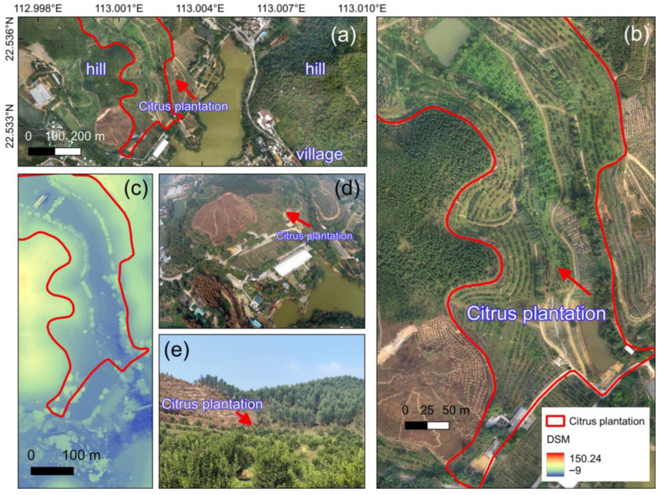
2.1. UAV Application Scenario—Citrus Plantations
2.2. Using UAVs to Conduct Citrus Distribution Surveys
2.3. Preparation of Experimental Conditions
- (1)
- UAV Equipment. The DJI Phantom 4 RTK UAV is used as the mission equipment for this practical activity. Produced by DJI, headquartered in Shenzhen, China, this product is positioned as an entry-level industry drone, with relatively simple operation, making it easier for students to quickly master UAV operation skills.
- (2)
- Software. QGIS software is used to delineate the aerial survey mission area and complete task zoning and group assignments.
3. Conception and Design of the Practical Plan
3.1. Experimental Organization and Design
- (1)
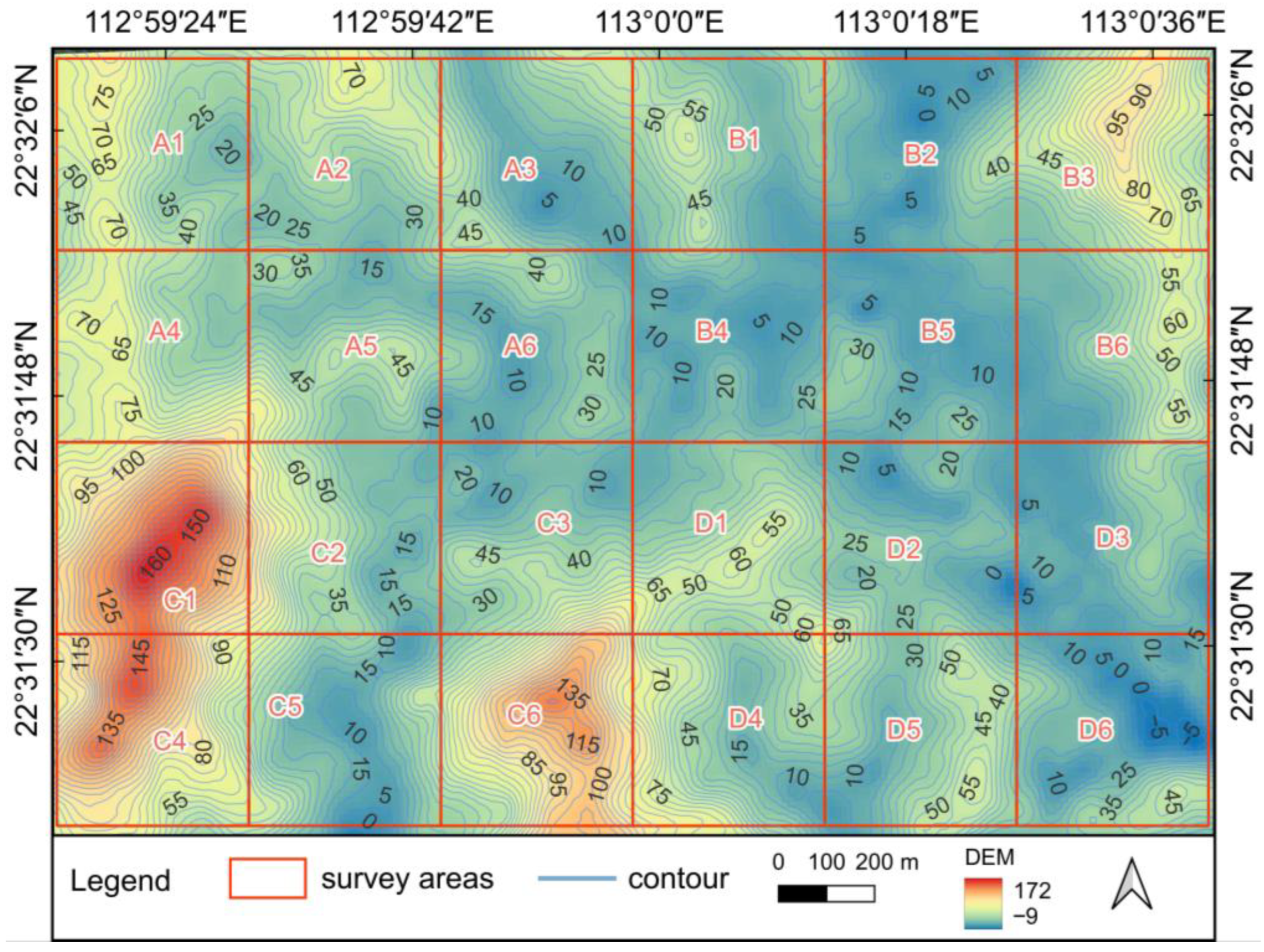
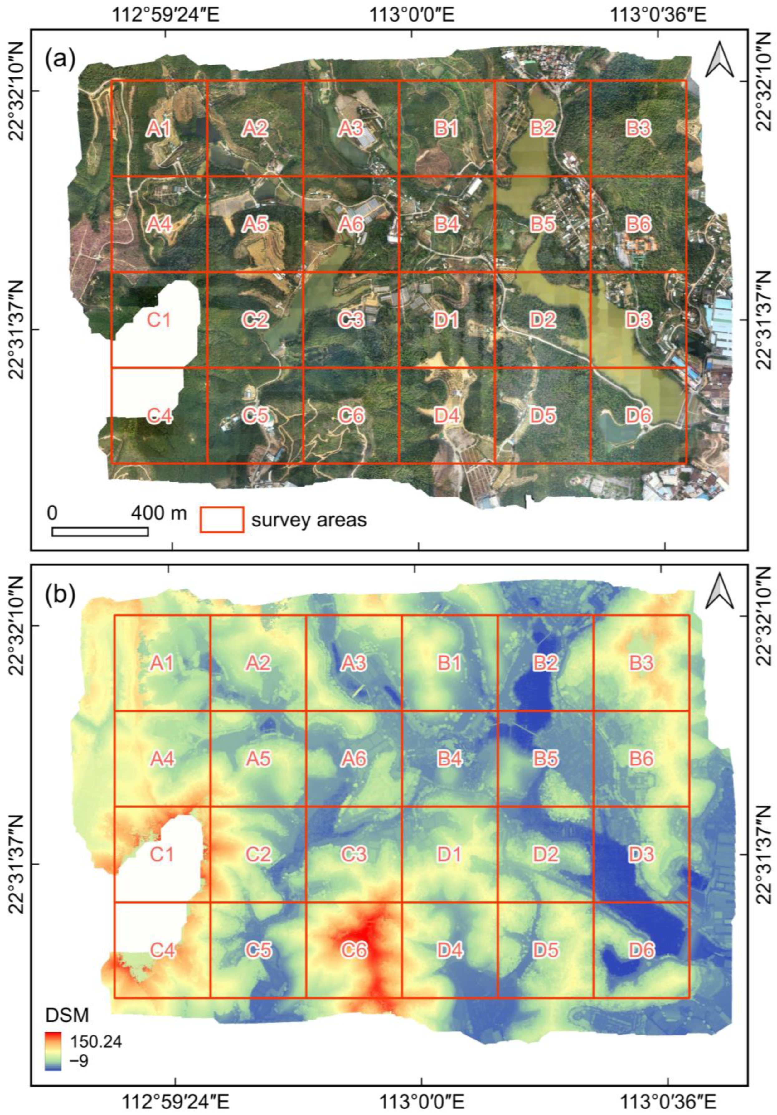
- Students Grouping. The experiment was guided by 4 instructors. A total of 28 students were divided into 4 groups (A, B, C, and D) with 7 students each, each supervised by one instructor (Table 2). Each group was responsible for 6 designated plots. Task assignments and plot numbering are shown in Table 1 and Figure 2.
- (2)
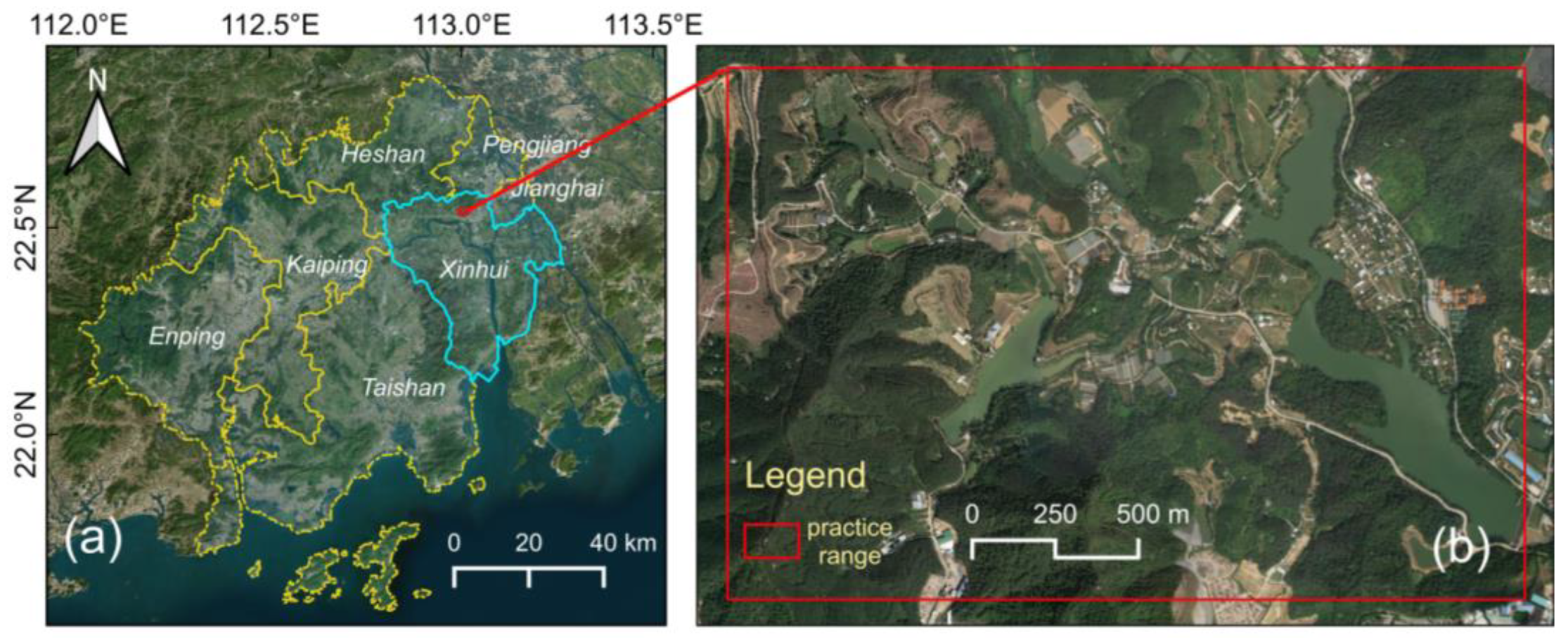
- Tasks Zoning. The experimental area is divided into zones. The planned experimental range was approximately 2.4 km × 1.6 km (total area 3.84 km2). Based on the empirical safe flight operation range per single mission for the DJI Phantom 4 RTK (considering battery life, signal stability, and safe return-to-home requirements), and considering the complex terrain of the experimental area requiring a reduction in the operational scope per single flight, the suitable operational unit per flight was set to 400 m × 400 m (0.16 km2). Therefore, the entire experimental area was divided into a grid of 6 rows by 4 columns, resulting in 24 plots, each corresponding to one aerial survey mission per flight.
- (3)
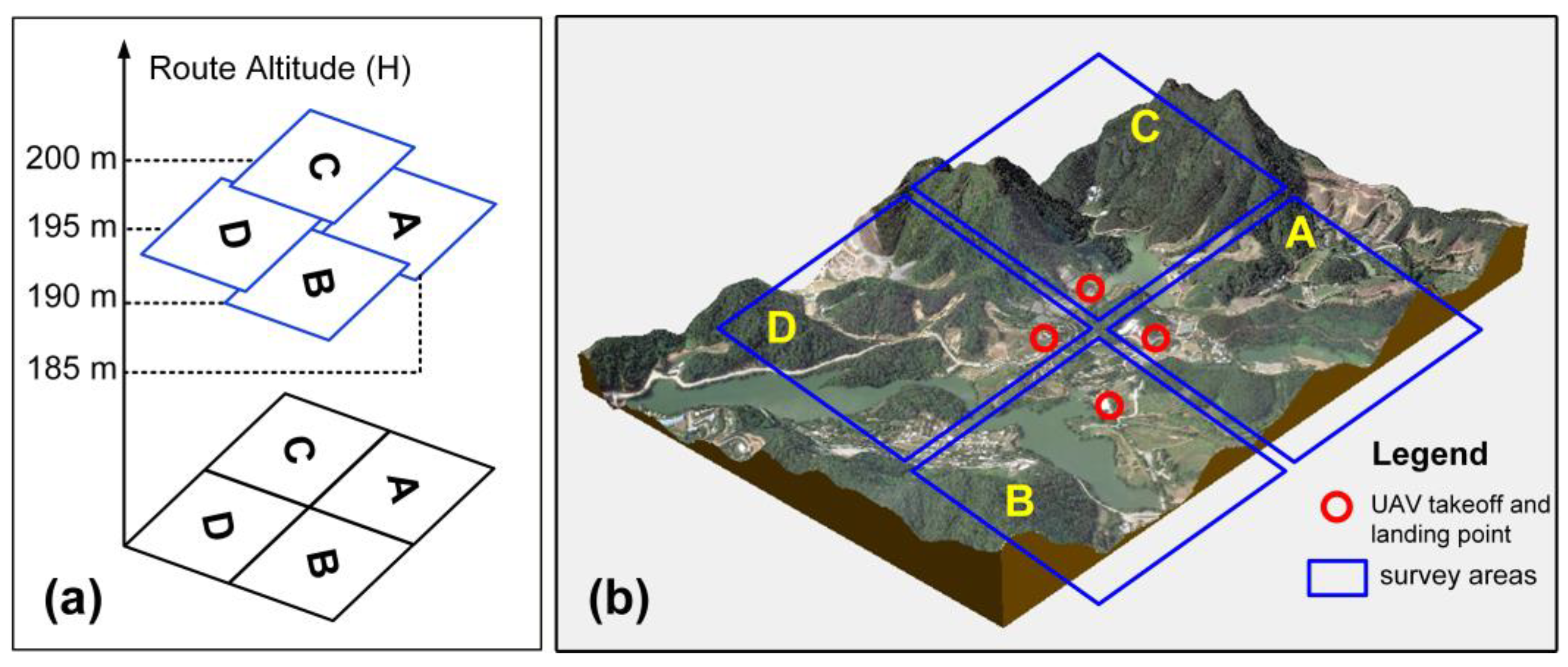
- Operational Layering. Based on the Digital Elevation Model (DEM) data for the experimental area, the highest surface elevation (175 m) was extracted (Figure 3). Considering the height of obstacles such as trees and power lines, a safety margin was added, and the planned baseline flight altitude was set at 200 m (approximately 25 m above the highest point). To prevent collisions during simultaneous drone operations by different groups, the flight altitudes for the four groups were stratified with 5 m intervals: Group A at 185 m, Group B at 190 m, Group C at 200 m, and Group D at 195 m (Figure 4). The lowest altitude (185 m) remains above all obstacles, ensuring flight safety.
3.2. Indoor Preparatory Work
3.2.1. Planning Survey Areas
- (1)
- Determining Single-Flight Operational Range
- (2)
- Group-based Zonal Task Planning
- Load the online map. In the HCMGIS plugin, select Basemaps, then add Google Imagery.
- Zoom in to the target area in Google Imagery, create a new Shapefile layer. In the parameter settings, select “Polygon” as the geometry type, and choose the projected coordinate system WGS 1984 UTM Zone 49N.
- Draw a rectangle measuring 400 m × 400 m. (1) Click the edit button to activate the Shapefile layer for editing. (2) Left click the “Add Polygon Feature” button, and select “Digitize with Line Segments” as the digitization tool. (3) Then, click to activate the advanced digitization tool. When the cursor changes to a crosshair, create the initial point. After clicking the first point, set the advanced digitization tool to snap to common angles (90°, 180°, 270°, and 360°) and fix the distance to 400 m. Sequentially create the other three corner points to form a 400 m × 400 m rectangle. This geometry represents a single-flight mission area. Copy and paste multiple rectangle geometries, drag them with the mouse to tile them across the experimental area, arranging them according to the grid layout described in Section 3.1, ensuring each rectangle corresponds to one mission plot, totaling 24 plots.
- Task numbering. Open the attribute table, add a field, set the field type to text, and number each geometry one by one. The numbers correspond to the task plots of each group, with A, B, C, and D representing group numbers and 1~6 representing task numbers. For example, A1 and B3 indicate the first flight task of Group 1 and the third flight task of Group 2, respectively.
- Estimating appropriate flight altitude. In QGIS, the DEM data is converted into contour lines, which are used to preliminarily determine the suitable flight altitude for each mission plot.
- Format conversion. DJI drones support mission modes that generate flight routes based on kmz/kml files. Therefore, the geometries in the Shapefile need to be converted one by one into kmz/kml files.
- Import data and check flight routes. Create a new folder named “DJI” in the root directory of the UAV remote controller’s memory card, and then create a folder named “kml” within the “DJI” folder. Copy the kml format aerial survey operation scope files to the “kml” folder. Start the UAV aircraft and remote controller respectively. On the remote controller, select “Import kmz task” and check if the drone flight route is generated correctly. Verify that the route area for each plot matches expectations and that there are no no-fly zone conflicts, ensuring that kml files can be directly called upon during fieldwork to generate the mission route.
3.2.2. Setting Flight Path Parameters
- (1)
- Setting Flight Altitude
- In QGIS, contour lines were generated from DEM data to examine ground elevations within task areas. The relationship between the ground sampling distance (GSD) and flight altitude for the visible light sensor on the DJI Phantom 4 RTK is as follows:where GSD (ground sampling distance) is in cm, and H (flight altitude) is in m. At 200 m altitude, the ground resolution is approximately 5.5 cm. At a flight altitude of 200 m, the ground resolution is approximately 5.5 cm. Combined with the analysis in Section 3.1, the designed flight altitudes for Groups A, B, C, and D are 185 m, 190 m, 200 m, and 195 m, respectively. All flight altitudes are above the highest point, and the 5 m interval between groups ensures vertical safety distance.
- (2)
- Setting Overlap Rates. To ensure image stitching quality, the forward overlap rate was set to 80%, and the side overlap rate was set to 70%. This parameter is based on the default recommended values for the DJI Phantom 4 RTK drone, adjusted slightly considering the terrain undulation to ensure sufficient matching features even in complex terrain.
- (3)
- Camera Parameters. Set camera parameters according to weather conditions. Select Sunny mode for sunny operations and Cloudy mode for overcast operations. White balance is set to Auto, ISO is set to 100 to reduce noise, and shutter speed is prioritized to avoid overexposure or motion blur.
3.2.3. Selecting Suitable Takeoff and Landing Points
3.3. UAV-Operation-Skills Training
- (1)
- Online Simulation. The Phoenix RC simulator is used as flight simulation software. Through this software, students master basic UAV operations such as takeoff, landing, and rotation.
- (2)
- Understanding UAV Equipment. Students are guided to learn the basics of operating the DJI Phantom 4 UAV, including equipment assembly and flight path parameter settings.
- (3)
- Guided Practice. Students practice UAV operations in open areas (e.g., playgrounds, etc.).
3.4. On-Site Condition Survey
- Meteorological conditions: wind force must be below level 5, with no heavy fog, rainfall, or snowfall.
- Environmental survey of the experimental site: observe the height of ground obstacles within the flight range, such as high-voltage lines, signal towers, and chimneys, and verify whether the preset flight route altitude is appropriate. Assess the suitability of the takeoff and landing points, ensuring they are located in relatively open areas and free from obstructions.
- Inspection of experimental equipment: before commencing UAV-flight operations, check that the UAV aircraft and remote controller are in good condition, verify that the battery level is sufficient, and confirm that the memory card is properly installed, among other checks.
3.5. Indoor Data Processing
- (1)
- Align Photos.
- (2)
- Build Dense Cloud.
- (3)
- Build DEM.
- (4)
- Build Orthomosaic, with the surface parameter set to “Mesh”.
4. Experimental Summary
4.1. Improvement of UAV Outdoor Practical Skills
4.2. Development of Problem-Solving Skills
4.3. Development of Team Collaboration Skills
4.4. Enhancement of Ecological Awareness
- (1)
- Identify the spatial distribution of citrus trees based on the UAV images and summarize their spatial distribution characteristics.
- (2)
- Analyze the reasons for the contour-based distribution of citrus forests. What is the relationship between this distribution pattern and land-use methods?
- (3)
- What is the connection between constructing terraces in hilly areas and the regional environmental characteristics? What are the benefits of doing so?
5. Discussion
5.1. Potential Application Scenarios of the Teaching Case
5.2. Organizational Model of the Teaching Case
5.3. Teaching Procedure Design and the Integration of Ecological Education Concepts
5.4. Promotion Value
5.5. Limitations and Challenges
6. Conclusions
Author Contributions
Funding
Institutional Review Board Statement
Informed Consent Statement
Data Availability Statement
Conflicts of Interest
Abbreviations
| UAV | unmanned aerial vehicle |
| DEM | digital elevation model |
| DSM | digital surface model |
References
- Kobori, H.; Dickinson, J.L.; Washitani, I.; Sakurai, R.; Amano, T.; Komatsu, N.; Kitamura, W.; Takagawa, S.; Koyama, K.; Ogawara, T.; et al. Citizen science: A new approach to advance ecology, education, and conservation. Ecol. Res. 2016, 31, 1–19. [Google Scholar] [CrossRef]
- Zhu, X.; Zhao, T. Integrating Ecological Civilization into Education. In Handbook of Ecological Civilization: Concept, Philosophy, and Pedagogy; Peters, M.A., Green, B.J., Misiaszek, G.W., Zhu, X., Eds.; Springer Nature: Singapore, 2025; pp. 1–15. [Google Scholar]
- Liu, Y.; Feng, W. A metric analysis of the knowledge map of ecological civilization education in China. Asia Pac. Educ. Rev. 2025. [Google Scholar] [CrossRef]
- Saribas, D.; Kucuk, Z.D.; Ertepinar, H. Implementation of an environmental education course to improve pre-service elementary teachers’ environmental literacy and self-efficacy beliefs. Int. Res. Geogr. Environ. Educ. 2017, 26, 311–326. [Google Scholar] [CrossRef]
- Yolcu, H.H. Using project-based learning in an environmental education course and revealing students’ experiences: A case study. Sci. Act. 2023, 60, 119–125. [Google Scholar] [CrossRef]
- Byrne, L.B.; Rauschert, E.S.J.; Rodgers, V.L.; Bowser, G.; Casper, A.; Dewsbury, B.; Morales, N.; Vance-Chalcraft, H.D.; Weber, L. Diversifying Ecology Education for Everyone Through More Inclusive, Interdisciplinary, and Accessible Teaching. Bull. Ecol. Soc. Am. 2025, 106, e2233. [Google Scholar] [CrossRef]
- Ruhl, N.; Crumrine, P.; Oberle, J.; Richmond, C.; Thomas, S.; Wright, S. Harnessing the Four-Dimensional Ecology Education Framework to redesign an introductory ecology course in a changing higher education landscape. Ecosphere 2022, 13, e03857. [Google Scholar] [CrossRef]
- Wang, R.; Qi, R.; Cheng, J.; Zhu, Y.; Lu, P. The behavior and cognition of ecological civilization among Chinese university students. J. Clean. Prod. 2020, 243, 118464. [Google Scholar] [CrossRef]
- Chen, J.; Mu, X.; Tu, C.; Hu, G. Influence of ecological cognition on consumers’ willingness to participate in beverage packaging recycling. Resour. Conserv. Recycl. Adv. 2022, 14, 200070. [Google Scholar] [CrossRef]
- Krasny, M. Advancing Environmental Education Practice; Cornell University Press: New York, NY, USA, 2020. [Google Scholar]
- Bogner, F.X. The Influence of Short-Term Outdoor Ecology Education on Long-Term Variables of Environmental Perspective. J. Environ. Educ. 1998, 29, 17–29. [Google Scholar] [CrossRef]
- Lugg, A. Developing sustainability-literate citizens through outdoor learning: Possibilities for outdoor education in Higher Education. J. Adventure Educ. Outdoor Learn. 2007, 7, 97–112. [Google Scholar] [CrossRef]
- Jeronen, E.; Palmberg, I.; Yli-Panula, E. Teaching Methods in Biology Education and Sustainability Education Including Outdoor Education for Promoting Sustainability—A Literature Review. Educ. Sci. 2017, 7, 1. [Google Scholar] [CrossRef]
- Hansen, A.S.; Sandberg, M. Reshaping the outdoors through education: Exploring the potentials and challenges of ecological restoration education. J. Outdoor Environ. Educ. 2020, 23, 57–71. [Google Scholar] [CrossRef]
- Korcz, N.; Kamińska, A.; Ciesielski, M. Ecological Education in the City: Who, How, and with What Effect Educates the Residents of the Warsaw Metropolitan Area—Preliminary Research in Poland. Forests 2026, 17, 275. [Google Scholar] [CrossRef]
- Xu, J.; Huang, Y.; Cheng, K.; Wang, Y.; Hu, T.; Guan, H.; Chen, Y.; Ren, Y.; Chen, M.; Yang, Z.; et al. Efficient large-scale vegetation mapping at the formation level using multi-source data: A case study in Beijing, China. ISPRS J. Photogramm. Remote Sens. 2025, 225, 36–51. [Google Scholar] [CrossRef]
- Ecke, S.; Dempewolf, J.; Frey, J.; Schwaller, A.; Endres, E.; Klemmt, H.-J.; Tiede, D.; Seifert, T. UAV-Based Forest Health Monitoring: A Systematic Review. Remote Sens. 2022, 14, 3205. [Google Scholar] [CrossRef]
- Shahbazi, M.; Théau, J.; Ménard, P. Recent applications of unmanned aerial imagery in natural resource management. GIScience Remote Sens. 2014, 51, 339–365. [Google Scholar] [CrossRef]
- Tan, E.; Pattyn, V.; Casiano Flores, C.; Crompvoets, J. A capacity assessment framework for the fit-for-purpose land administration systems: The use of unmanned aerial vehicle (UAV) in Rwanda and Kenya. Land Use Policy 2021, 102, 105244. [Google Scholar] [CrossRef]
- Deng, L.; Mao, Z.; Li, X.; Hu, Z.; Duan, F.; Yan, Y. UAV-based multispectral remote sensing for precision agriculture: A comparison between different cameras. ISPRS J. Photogramm. Remote Sens. 2018, 146, 124–136. [Google Scholar] [CrossRef]
- Yang, M.-D.; Hsu, Y.-C.; Tseng, W.-C.; Tseng, H.-H.; Lai, M.-H. Precision assessment of rice grain moisture content using UAV multispectral imagery and machine learning. Comput. Electron. Agric. 2025, 230, 109813. [Google Scholar] [CrossRef]
- Chen, A.; Cheng, K.; Chen, Y.; Qi, Z.; Yang, H.; Ren, Y.; Yang, Z.; Chen, M.; Xu, J.; Zhang, Y.; et al. Validating recent global canopy height maps over China’s forests based on UAV lidar data. Remote Sens. Environ. 2025, 329, 114957. [Google Scholar] [CrossRef]
- Yu, T.; Ni, W.; Liu, J.; Zhao, R.; Zhang, Z.; Sun, G. Extraction of tree heights in mountainous natural forests from UAV leaf-on stereoscopic imagery based on approximation of ground surfaces. Remote Sens. Environ. 2023, 293, 113613. [Google Scholar] [CrossRef]
- Yin, D.; Wang, L.; Lu, Y.; Shi, C. Mangrove tree height growth monitoring from multi-temporal UAV-LiDAR. Remote Sens. Environ. 2024, 303, 114002. [Google Scholar] [CrossRef]
- Cai, S.; Zhang, W.; Zhang, S.; Yu, S.; Liang, X. Branch architecture quantification of large-scale coniferous forest plots using UAV-LiDAR data. Remote Sens. Environ. 2024, 306, 114121. [Google Scholar] [CrossRef]
- Zhang, L.; Zhang, H.; Niu, Y.; Han, W. Mapping Maize Water Stress Based on UAV Multispectral Remote Sensing. Remote Sens. 2019, 11, 605. [Google Scholar] [CrossRef]
- Zou, J.; Li, H.; Ding, C.; Liu, S.; Shi, Q. Mapping Natural Populus euphratica Forests in the Mainstream of the Tarim River Using Spaceborne Imagery and Google Earth Engine. Remote Sens. 2024, 16, 3429. [Google Scholar] [CrossRef]
- Hao, L.; Qingdong, S.; Imin, B.; Kasim, N. Methodology for optimizing quadrat size in sparse vegetation surveys: A desert case study from the Tarim Basin. PLoS ONE 2020, 15, e0235469. [Google Scholar] [CrossRef] [PubMed]
- Morgan, G.R.; Mathews, A.J. Drones in Geography Higher Education Curriculum: Where Are We? Prof. Geogr. 2025, 77, 217–228. [Google Scholar] [CrossRef]
- Rogers, S.R.; Singh, K.K.; Mathews, A.J.; Cummings, A.R. Drones and Geography: Who Is Using Them and Why? Prof. Geogr. 2022, 74, 516–528. [Google Scholar] [CrossRef]
- Robinson, J.M.; Harrison, P.A.; Mavoa, S.; Breed, M.F. Existing and emerging uses of drones in restoration ecology. Methods Ecol. Evol. 2022, 13, 1899–1911. [Google Scholar] [CrossRef]
- Buchelt, A.; Adrowitzer, A.; Kieseberg, P.; Gollob, C.; Nothdurft, A.; Eresheim, S.; Tschiatschek, S.; Stampfer, K.; Holzinger, A. Exploring artificial intelligence for applications of drones in forest ecology and management. For. Ecol. Manag. 2024, 551, 121530. [Google Scholar] [CrossRef]
- Bolick, M.M.; Mikhailova, E.A.; Post, C.J. Teaching Innovation in STEM Education Using an Unmanned Aerial Vehicle (UAV). Educ. Sci. 2022, 12, 224. [Google Scholar] [CrossRef]
- Stöcker, C.; Bennett, R.; Nex, F.; Gerke, M.; Zevenbergen, J. Review of the Current State of UAV Regulations. Remote Sens. 2017, 9, 459. [Google Scholar] [CrossRef]
- Alamouri, A.; Berger, C. Teaching UAV Photogrammetry in Non-Geodetic Degree Courses: The Example of TU Braunschweig. PFG—J. Photogramm. Remote Sens. Geoinf. Sci. 2025, 93, 309–316. [Google Scholar] [CrossRef]
- Cliffe, A.D. Evaluating the introduction of unmanned Aerial Vehicles for teaching and learning in geoscience fieldwork education. J. Geogr. High. Educ. 2019, 43, 582–598. [Google Scholar] [CrossRef]
- Pergantis, P.; Drigas, A. The Effect of Drones in the Educational Process: A Systematic Review. Educ. Sci. 2024, 14, 665. [Google Scholar] [CrossRef]
- He, X.; Hua, X.; Montillet, J.-P.; Yu, K.; Zou, J.; Xiang, D.; Zhu, H.; Zhang, D.; Huang, Z.; Zhao, B. An Innovative Virtual Simulation Teaching Platform on Digital Mapping with Unmanned Aerial Vehicle for Remote Sensing Education. Remote Sens. 2019, 11, 2993. [Google Scholar] [CrossRef]
- Li, X.; Yang, Y.; Zhu, Y.; Ben, A.; Qi, J. A novel strategy for discriminating different cultivation and screening odor and taste flavor compounds in Xinhui tangerine peel using E-nose, E-tongue, and chemometrics. Food Chem. 2022, 384, 132519. [Google Scholar] [CrossRef]
- Zhang, J.; Wu, X.; Qiu, J.; Zhang, L.; Zhang, Y.; Qiu, X.; Huang, Z.; Xu, W. Comprehensive Comparison on the Chemical Profile of Guang Chen Pi at Different Ripeness Stages Using Untargeted and Pseudotargeted Metabolomics. J. Agric. Food Chem. 2020, 68, 8483–8495. [Google Scholar] [CrossRef]
- Russo, F.; Rindone, C. Methods for Risk Reduction: Training and Exercises to Pursue the Planned Evacuation. Sustainability 2024, 16, 1474. [Google Scholar] [CrossRef]
- Rossi, F.; Castellani, B.; Pazzaglia, A.; Di Giuseppe, A.; Bonafoni, S.; Filipponi, M.; Presciutti, A.; Cotana, F. Application of the novel satellite calibrated method “Radiative Forcing Meter” on a high albedo test facility for CO2 compensation. Sol. Energy 2023, 263, 111934. [Google Scholar] [CrossRef]
- Shadiev, R.; Yi, S. A systematic review of UAV applications to education. Interact. Learn. Environ. 2023, 31, 6165–6194. [Google Scholar] [CrossRef]
- Murillo, D.A.; Laguna, N.A.; Morales Peña, V.H. Technological and Digital Transfer Within the Work and Professional Experience Courses at EARTH University. 2025. Available online: https://docs.lib.purdue.edu/sydag/2025/posters/4/ (accessed on 19 March 2026).
- Martino, A.; Chiabrando, F.; Lingua, A.M. UAS for Landscape and Architectural Survey: An Innovative Interdisciplinary Approach of Learning by Doing in the Bachelor Programs at Politecnico di Torino. Int. Arch. Photogramm. Remote Sens. Spat. Inf. Sci. 2025, 48, 195–202. [Google Scholar] [CrossRef]
- Yeung, R.C.Y.; Yeung, C.H.; Sun, D.; Looi, C.-K. A systematic review of Drone integrated STEM education at secondary schools (2005–2023): Trends, pedagogies, and learning outcomes. Comput. Educ. 2024, 212, 104999. [Google Scholar] [CrossRef]
- Ziegler, H.H.; Ryu, J. Designing Drone-Based Solutions for Climate Education in Secondary Schools. Sci. Teach. 2025, 92, 58–65. [Google Scholar] [CrossRef]
- Yang, B.; Hawthorne, T.L.; Hessing-Lewis, M.; Duffy, E.J.; Reshitnyk, L.Y.; Feinman, M.; Searson, H. Developing an Introductory UAV/Drone Mapping Training Program for Seagrass Monitoring and Research. Drones 2020, 4, 70. [Google Scholar] [CrossRef]
- Rattanagraikanakorn, B.; Blom, H.A.P.; Gransden, D.I.; Schuurman, M.; De Wagter, C.; Sharpanskykh, A.; Happee, R. Effect of Design on Human Injury and Fatality Due to Impacts by Small UAS. Designs 2025, 9, 88. [Google Scholar] [CrossRef]
- Liu, J.; Chen, Y.; Wang, R.; Chen, Y. Complex task planning method of space-aeronautics cooperative observation based on multi-layer interaction. J. Syst. Eng. Electron. 2023, 34, 1550–1564. [Google Scholar] [CrossRef]
- Rindone, C.; Russo, A. Disaster Risk Reduction in a Manhattan-Type Road Network: A Framework for Serious Game Activities for Evacuation. Sustainability 2025, 17, 6326. [Google Scholar] [CrossRef]
- Lobo, D.; Patel, D.; Morainvile, J.; Shekhar, P.; Abichandani, P. Preparing Students for Drone Careers Using Active Learning Instruction. IEEE Access 2021, 9, 126216–126230. [Google Scholar] [CrossRef]
- Stoica, C.; Bertrand, S.; Burlion, L. Feedback on Drone Arenas-based Remote international Teaching—DAReTeach. IFAC-Pap. 2024, 58, 135–140. [Google Scholar] [CrossRef]
- Abichandani, P.; Lobo, D.; Dimitrijevic, B.; Borgaonkar, A.; Sodhi, J.; Kabrawala, S.; Brateris, D.; Kam, M. Competition-based active learning instruction for drone education. Interact. Learn. Environ. 2024, 32, 1795–1813. [Google Scholar] [CrossRef]
- Wilkerson, S.A.; Gadsden, S.A.; Gadsden, A.D. An unmanned aerial system for the detection of crops with undergraduate project-based learning. In Autonomous Air and Ground Sensing Systems for Agricultural Optimization and Phenotyping III; SPIE: Bellingham, WA, USA, 2018. [Google Scholar]
- Williams, V.; Unger, D.; Kulhavy, D.; Hung, I.; Zhang, Y. Assessing Drone Mapping Capabilities and Increased Cognitive Retention Using Interactive Hands-On Natural Resource Instruction. High. Educ. Stud. 2023, 13, 28–36. [Google Scholar] [CrossRef]
- Wu, P.Q.; Ding, T.J.; Wu, Y.J.; Tarng, W. Development of a Virtual Drone System for Exploring Natural Landscapes and Enhancing Junior High School Students’ Learning of Indigenous Settlement Site Selection. Drones 2025, 9, 742. [Google Scholar] [CrossRef]
- Wu, Y.-J.; Ding, T.-J.; Hsu, J.-C.; Ou, K.-L.; Tarng, W. Exploratory Learning of Amis Indigenous Culture and Local Environments Using Virtual Reality and Drone Technology. ISPRS Int. J. Geo-Inf. 2025, 14, 441. [Google Scholar] [CrossRef]
- Moon, S.; Ock, J. Developing the Framework of Drone Curriculum to Educate the Drone Beginners in the Korean Construction Industry. Drones 2023, 7, 356. [Google Scholar] [CrossRef]
- Taddia, Y.; González-García, L.; Zambello, E.; Pellegrinelli, A. Quality Assessment of Photogrammetric Models for Façade and Building Reconstruction Using DJI Phantom 4 RTK. Remote Sens. 2020, 12, 3144. [Google Scholar] [CrossRef]
- Burner, N.; Harris, D.K.; Li, Z. SHP Buddy: A QGIS plugin for generating shapefiles to support remote sensing in plant breeding and agronomic experiments. Plant Methods 2025, 21, 17. [Google Scholar] [CrossRef]

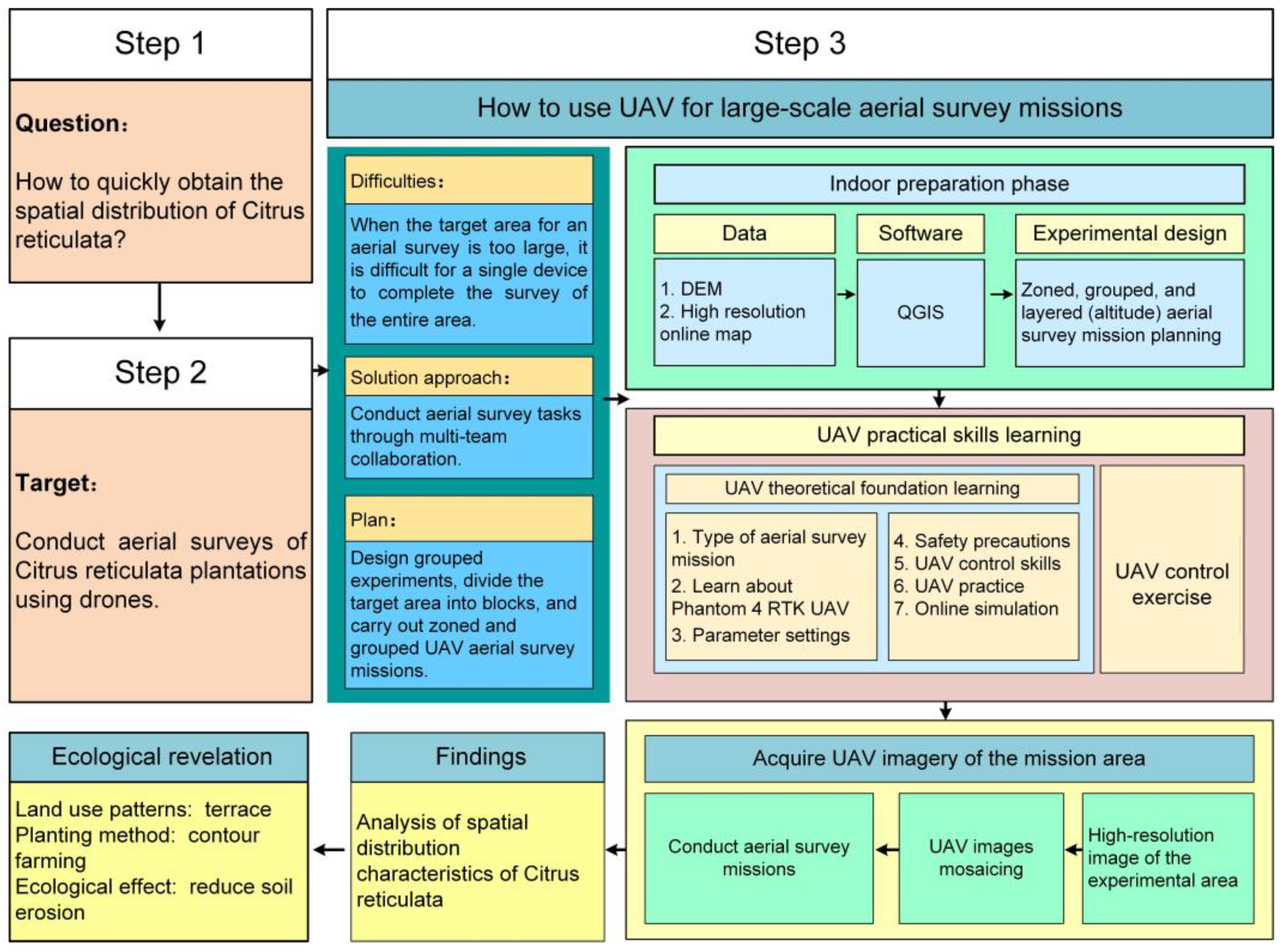



| Problem Description | Problem Decomposition | Corresponding Solution |
|---|---|---|
| Problem 1: How to quickly obtain the spatial distribution of citrus plantation? |
| See Section 3.1 for solutions |
| Problem 2: How to design a multiple UAVs collaborative data-acquisition experiment? |
| See Section 3.2 for solutions |
| Problem 3: Is it necessary to assess the field environment in outdoor settings to ensure UAV flight safety? |
| See Section 3.3 for solutions |
| Problem 4: What is the UAV-image-processing workflow? |
| See Section 3.4 for solutions |
| Group | Students Number | Experimental Equipment (UAV) | Task IDs |
|---|---|---|---|
| A | 7 | 1× DJI Phantom 4 RTK, 6 batteries | A1/A2/A3/A4/A5/A6 |
| B | 7 | 1× DJI Phantom 4 RTK, 6 batteries | B1/B2/B3/B4/B5/B6 |
| C | 7 | 1× DJI Phantom 4 RTK, 6 batteries | C1/C2/C3/C4/C5/C6 |
| D | 7 | 1× DJI Phantom 4 RTK, 6 batteries | D1/D2/D3/D4/D5/D6 |
Disclaimer/Publisher’s Note: The statements, opinions and data contained in all publications are solely those of the individual author(s) and contributor(s) and not of MDPI and/or the editor(s). MDPI and/or the editor(s) disclaim responsibility for any injury to people or property resulting from any ideas, methods, instructions or products referred to in the content. |
© 2026 by the authors. Licensee MDPI, Basel, Switzerland. This article is an open access article distributed under the terms and conditions of the Creative Commons Attribution (CC BY) license.
Share and Cite
Li, H.; Xie, Z.; Liu, S. The Design and Practice of an Experimental Teaching Case for UAV-Based Field-Data Acquisition in Outdoor Ecological Education. Sustainability 2026, 18, 3340. https://doi.org/10.3390/su18073340
Li H, Xie Z, Liu S. The Design and Practice of an Experimental Teaching Case for UAV-Based Field-Data Acquisition in Outdoor Ecological Education. Sustainability. 2026; 18(7):3340. https://doi.org/10.3390/su18073340
Chicago/Turabian StyleLi, Hao, Zhiying Xie, and Suhong Liu. 2026. "The Design and Practice of an Experimental Teaching Case for UAV-Based Field-Data Acquisition in Outdoor Ecological Education" Sustainability 18, no. 7: 3340. https://doi.org/10.3390/su18073340
APA StyleLi, H., Xie, Z., & Liu, S. (2026). The Design and Practice of an Experimental Teaching Case for UAV-Based Field-Data Acquisition in Outdoor Ecological Education. Sustainability, 18(7), 3340. https://doi.org/10.3390/su18073340