1. Introduction
Land subsidence, defined as the gradual lowering of the Earth’s surface due to subsurface deformation, has become one of the most widespread geohazards affecting urban environments globally [
1,
2,
3]. It is estimated that subsidence threatens more than 1.6 billion people worldwide, particularly in densely populated coastal and deltaic regions where rapid urbanization and groundwater extraction are prevalent [
4,
5,
6]. Major cities such as Jakarta [
7], Tokyo [
8], Shanghai [
9], Bangkok [
10], and Metro Manila [
11] have experienced significant subsidence over recent decades, resulting in increased flood risk, infrastructure damage, and long-term environmental degradation [
5,
12,
13]. In many of these cities, subsidence contributes more to relative sea-level rise than climate-driven ocean rise alone, significantly accelerating coastal vulnerability and disaster risk [
6,
14].
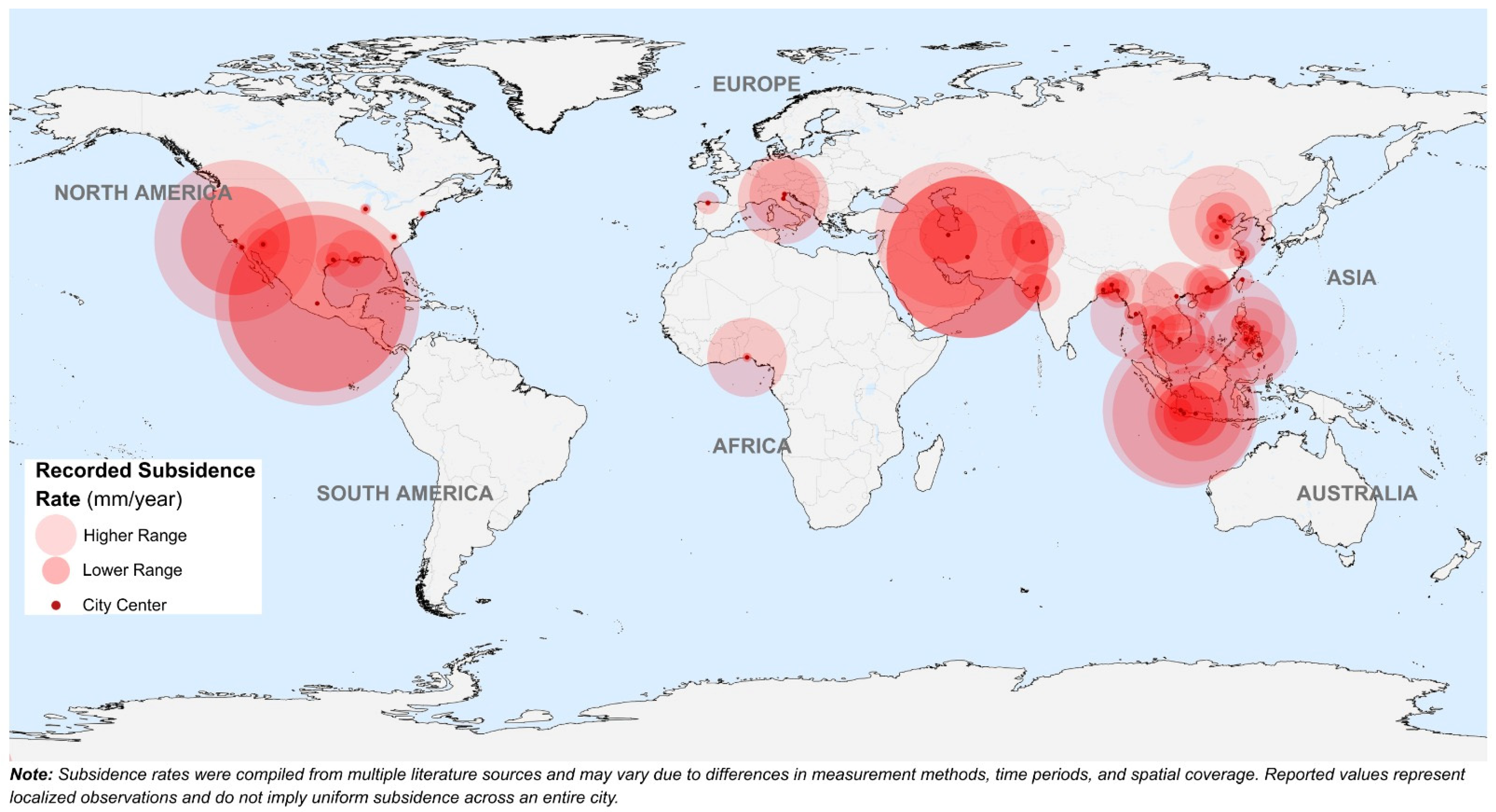
Figure 1 illustrates the global distribution and magnitude of reported subsidence in major cities, while the corresponding subsidence rate ranges and literature sources are summarized in
Appendix A Table A1. These values represent site-specific observations and may vary depending on measurement techniques and observation periods.
The primary hydrogeological mechanism driving land subsidence is groundwater extraction, which alters the equilibrium between pore water pressure and effective stress in aquifer systems [
15]. According to Terzaghi’s effective stress principle, reductions in groundwater levels increase the load carried by soil particles, leading to compaction of compressible sediments, particularly clay-rich aquitards [
15,
16,
17]. This compaction is often irreversible, resulting in permanent loss of aquifer storage capacity and progressive land surface lowering [
4,
18]. In addition to groundwater extraction, geological conditions such as sediment composition, aquifer thickness, and stratigraphic structure strongly influence subsidence magnitude and spatial variability [
5,
17,
19]. These hydrogeological processes operate over long time scales and can continue even after groundwater extraction is reduced due to delayed consolidation in fine-grained sediments [
20,
21].
Urbanization further intensifies subsidence by increasing groundwater demand and disrupting natural recharge processes [
22]. Rapid population growth, industrial expansion, and insufficient surface water supply often force cities to rely heavily on groundwater resources, accelerating aquifer depletion [
7,
23]. At the same time, the expansion of impervious surfaces reduces infiltration and limits natural aquifer recharge, exacerbating groundwater imbalance and compaction processes [
24]. As a result, subsidence has become strongly associated with urban vulnerability, contributing to increased flood frequency, infrastructure instability, and long-term economic losses [
6,
13,
25]. In coastal megacities, subsidence interacts with sea-level rise to significantly amplify flood hazards, creating complex challenges for urban sustainability and disaster risk management [
14,
26].
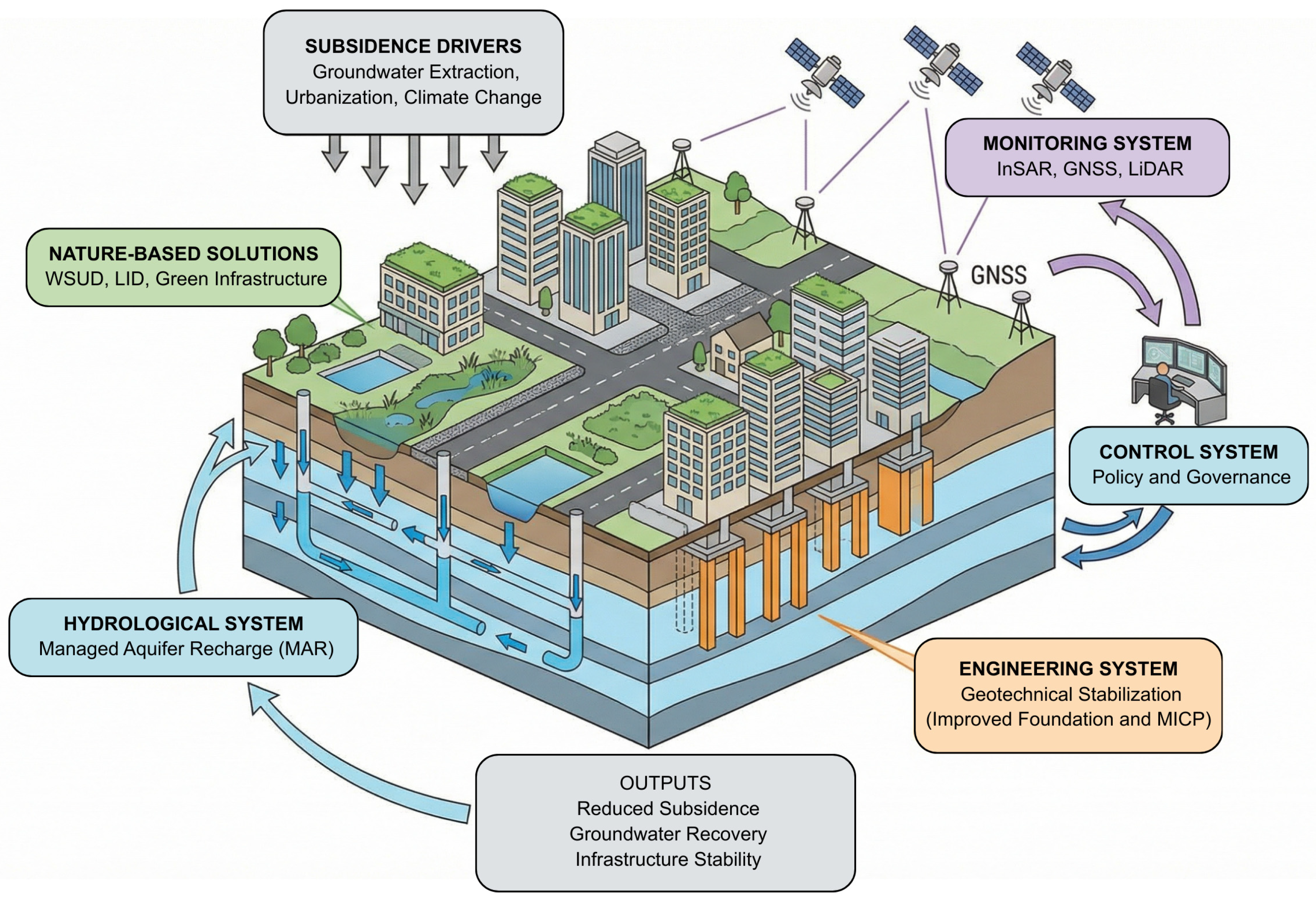
In response to these challenges, various mitigation and management strategies have been developed, including groundwater abstraction control, managed aquifer recharge, water-sensitive urban design, and geotechnical stabilization measures [
18,
27,
28]. Advances in satellite-based monitoring technologies, particularly Interferometric Synthetic Aperture Radar (InSAR), have significantly improved the detection and quantification of subsidence at regional and global scales, enabling a better understanding of its spatial patterns and drivers [
29,
30]. Despite these technological and management advances, subsidence continues in many urban areas due to complex interactions among hydrogeological processes, urban development, climate variability, and governance limitations [
5,
25,
31].
Although previous studies have extensively investigated individual aspects of land subsidence, significant limitations remain in the current literature. Many studies focus primarily on hydrogeological mechanisms without fully addressing the interconnected role of urban vulnerability and socio-environmental impacts [
4,
6,
25]. Other studies emphasize mitigation technologies but lack a comprehensive evaluation of their long-term effectiveness under varying geological and urban conditions [
18,
27,
28]. Furthermore, existing reviews often examine subsidence at local or regional scales, with limited synthesis integrating hydrogeological drivers, urban vulnerability, and sustainable management pathways at a global level, particularly in rapidly developing regions such as Southeast Asia [
7,
13,
31].
Therefore, the goal of this review is to provide a comprehensive synthesis of land subsidence by examining its hydrogeological drivers, assessing its impacts on urban vulnerability, and evaluating sustainable mitigation and management strategies. Specifically, this paper aims to: (1) explain the hydrogeological mechanisms controlling land subsidence, (2) evaluate the impacts of subsidence on urban systems and environmental sustainability, (3) review current mitigation and monitoring approaches, and (4) identify key research gaps and future directions to support sustainable urban groundwater management. By integrating hydrogeological processes, urban vulnerability, and sustainable mitigation pathways, this review contributes to a more comprehensive understanding of subsidence and supports the development of effective strategies to enhance urban resilience in subsidence-prone regions.
2. Methods
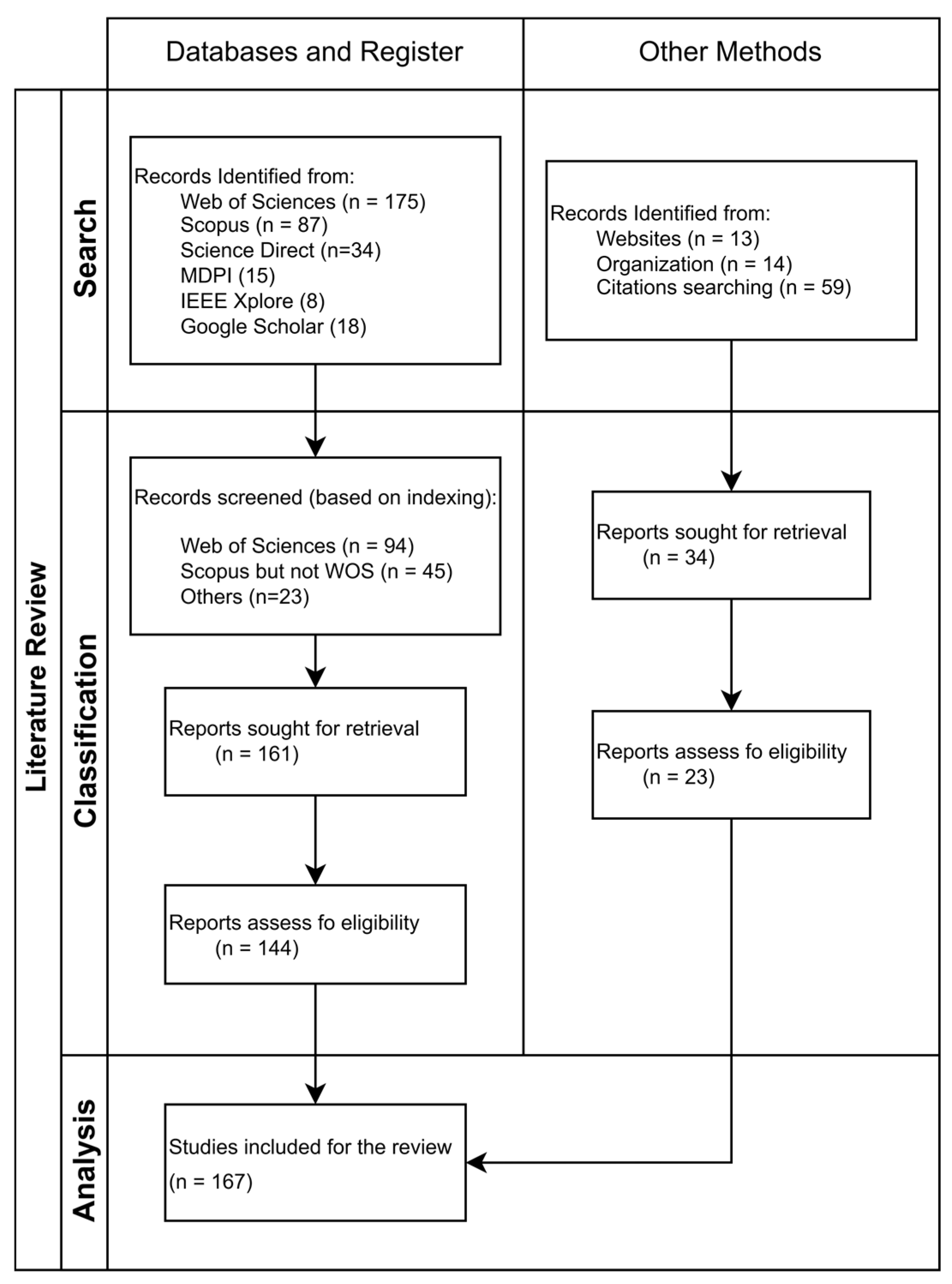
This study employed a systematic literature review to identify, evaluate, and synthesize existing knowledge on the hydrogeological drivers, impacts, and mitigation strategies of land subsidence. The review followed the Preferred Reporting Items for Systematic Reviews and Meta-Analyses (PRISMA) framework [
32], as shown in
Figure 2, to ensure transparency, reproducibility, and comprehensive coverage of relevant studies. Scientific publications were collected from major academic databases, including Scopus, Web of Science, and Google Scholar, with some known databases like Science Direct, MDPI, and IEEE, which provide extensive coverage of peer-reviewed journals, conference proceedings, and review articles.
The literature search focused on studies published between 1969 and 2026 to capture both foundational and recent advances in subsidence research. Keywords and combinations of terms used in the search included “land subsidence,” “ground subsidence,” “surface subsidence,” “groundwater extraction,” “aquifer compaction,” “urban subsidence,” “groundwater depletion,” “managed aquifer recharge,” “subsidence monitoring,” and “subsidence mitigation.” These keywords were applied to the title, abstract, and keyword fields in the selected databases. Boolean operators such as AND and OR were applied to refine the search and ensure inclusion of studies addressing hydrogeological processes, urban impacts, and mitigation approaches. Additional relevant studies were identified through reference screening of selected articles to ensure completeness.
The systematic review followed the PRISMA framework, which consists of four main stages: identification, screening, eligibility, and inclusion. During the identification stage, relevant studies were retrieved from major scientific databases, including Scopus, Web of Science, and Google Scholar, using predefined keywords related to land subsidence, groundwater extraction, aquifer compaction, urban subsidence, groundwater depletion, and subsidence mitigation. Boolean operators (AND/OR) were used to refine the search and capture a comprehensive set of publications addressing hydrogeological processes, urban vulnerability, and mitigation strategies.
In the screening stage, duplicate records were removed, and titles and abstracts were evaluated to exclude studies that were not directly related to groundwater-induced subsidence or urban subsidence processes. During the eligibility stage, full-text articles were assessed to determine their relevance to the objectives of this review. Studies were included if they provided quantitative or qualitative analysis of subsidence mechanisms, documented impacts on urban environments, or evaluated mitigation and monitoring strategies. Studies focusing solely on tectonic deformation or unrelated geological processes were excluded.
In the final inclusion stage, a total of 167 peer-reviewed publications were selected and synthesized. These studies were analyzed to identify key hydrogeological drivers, impacts, and mitigation approaches, forming the basis of the conceptual framework proposed in this study.
The PRISMA workflow was used to screen and select relevant publications. Duplicate records were first removed, followed by title and abstract screening to exclude studies unrelated to groundwater-induced subsidence. A full-text assessment was then conducted to ensure relevance to the study objectives, focusing on studies that provided hydrogeological analysis, documented subsidence impacts, or evaluated mitigation strategies. Only peer-reviewed publications written in English and containing sufficient technical and scientific detail were included. The inclusion and exclusion criteria applied during the screening process are summarized in
Table 1. Studies focused solely on tectonic subsidence or unrelated geological deformation were excluded to maintain focus on hydrogeological processes.
The final set of selected studies was synthesized using qualitative analysis to identify consistent patterns, dominant drivers, and effective mitigation strategies. Information from global case studies was compared to understand how subsidence mechanisms and management approaches vary across geological and urban settings. This systematic and structured methodology ensures that the findings of this review are based on comprehensive scientific evidence and provide a reliable foundation for the proposed global framework for sustainable land subsidence management.
3. Results
The systematic literature review identified 167 relevant peer-reviewed studies related to land subsidence drivers, impacts, and mitigation strategies after applying the PRISMA screening process. These studies were analyzed to examine temporal research trends, dominant research themes, and the relationships between hydrogeological processes, urban vulnerability, and subsidence mitigation approaches.
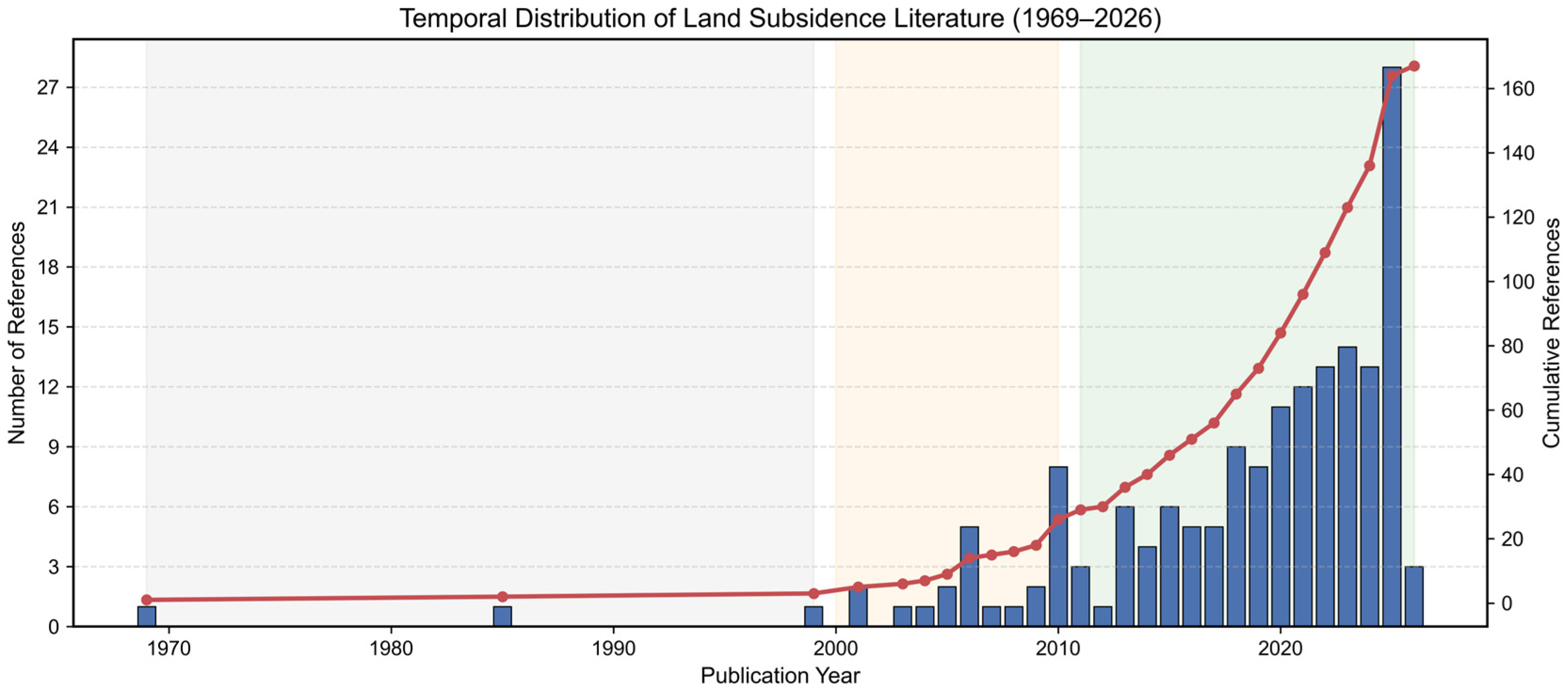
The temporal distribution of publications shows a clear increase in scientific attention to land subsidence over time, reflecting growing global concern regarding groundwater depletion, urbanization, and climate-related risks. As illustrated in
Figure 3, the number of publications has increased significantly since the early 2000s, with a particularly rapid growth in recent years driven by advances in satellite-based monitoring technologies and increasing recognition of subsidence as a major urban geohazard.
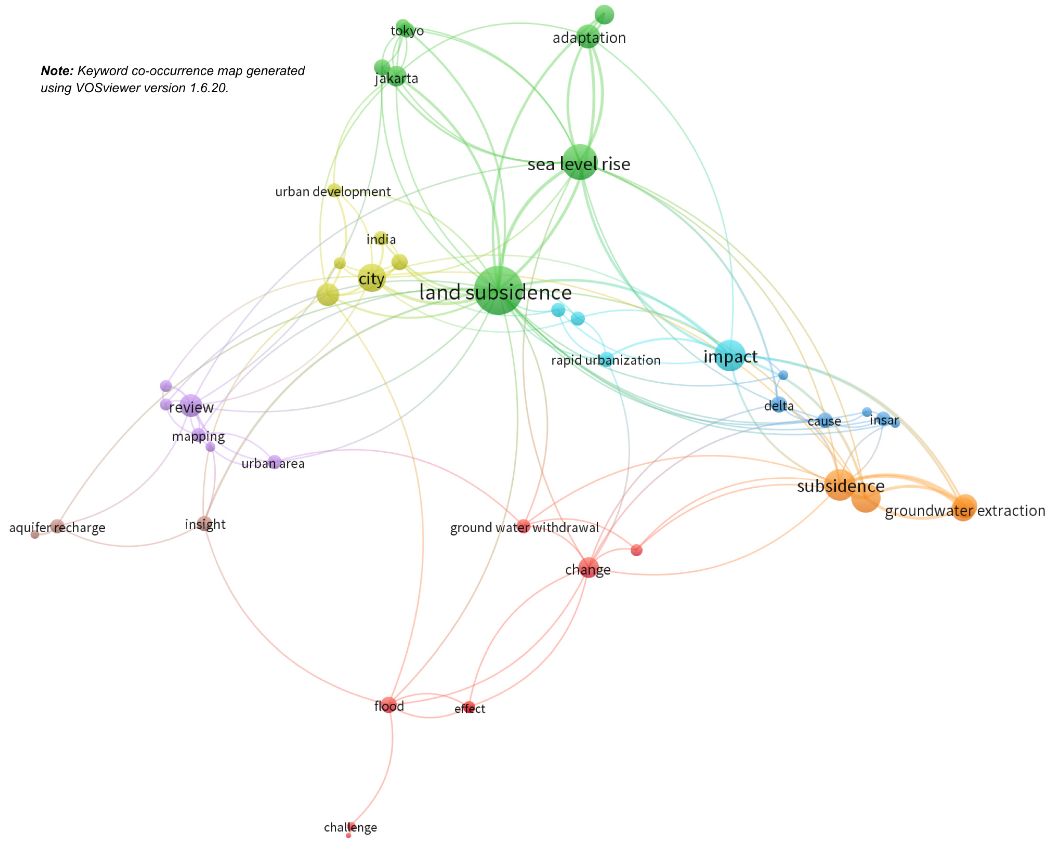
To further analyze research trends and relationships among subsidence drivers, impacts, and mitigation strategies, bibliometric network visualization (
Figure 4) was performed using keyword co-occurrence analysis. Keywords extracted from the selected publications were analyzed and visualized to identify dominant research themes, emerging topics, and interconnections between hydrogeological processes, urban vulnerability, and management approaches. Network visualization provides insight into the structure of subsidence research and highlights the integration between groundwater processes, monitoring technologies, and mitigation strategies.
Bibliometric network visualization was conducted using VOSviewer (version 1.6.20), a widely used software tool for constructing and visualizing bibliometric networks based on co-occurrence relationships among keywords, authors, or publications. VOSviewer applies distance-based mapping and clustering techniques to identify relationships between research topics and to reveal the structure of scientific knowledge within a specific field. The software has been widely applied in bibliometric and scientometric studies to analyze research trends and thematic evolution [
33,
34].
In this study, keyword co-occurrence analysis was performed using author keywords extracted from the selected publications. A minimum occurrence threshold of 5 keywords was applied to ensure that only frequently occurring terms were included in the analysis. The clustering resolution parameter was set to the default VOSviewer configuration, which automatically groups related keywords into clusters representing major research themes.
The keyword co-occurrence network reveals several major thematic clusters representing the dominant research directions in land subsidence studies. The first cluster is primarily associated with groundwater extraction, aquifer compaction, and groundwater depletion, highlighting the hydrogeological mechanisms responsible for land subsidence. The second cluster focuses on monitoring and assessment approaches, including remote sensing techniques such as InSAR, GNSS, and geodetic measurements used to detect and quantify land deformation. The third cluster emphasizes the impacts of subsidence on urban systems, including flood risk, infrastructure damage, and coastal vulnerability. Another cluster relates to subsidence mitigation and management strategies, including groundwater regulation, managed aquifer recharge, and sustainable urban water management.
These clusters illustrate the multidisciplinary nature of land subsidence research, where hydrogeological processes, technological monitoring tools, and urban sustainability considerations are increasingly integrated. The bibliometric network, therefore, highlights how subsidence research has evolved from a primarily geotechnical and hydrogeological focus toward broader themes involving urban resilience, climate adaptation, and sustainable groundwater management.
The geographic distribution of subsidence research also reflects the regions where land subsidence poses significant environmental and socio-economic challenges. Many of the studies included in this review originate from countries experiencing severe subsidence problems, particularly in Asia, North America, and parts of Europe, where rapid urbanization and intensive groundwater extraction have intensified ground deformation. For example, a substantial number of studies focus on major subsiding cities such as Jakarta, Shanghai, Bangkok, and Manila, which have attracted significant scientific attention due to their high subsidence rates and associated urban risks. This pattern suggests a strong correlation between the location of research institutions, study areas, and regions experiencing active subsidence, indicating that the urgency of local environmental challenges often drives research activity. At the same time, the concentration of studies in specific regions may also reflect differences in research capacity, data availability, and monitoring infrastructure across countries.
3.1. Hydrogeological Drivers of Land Subsidence
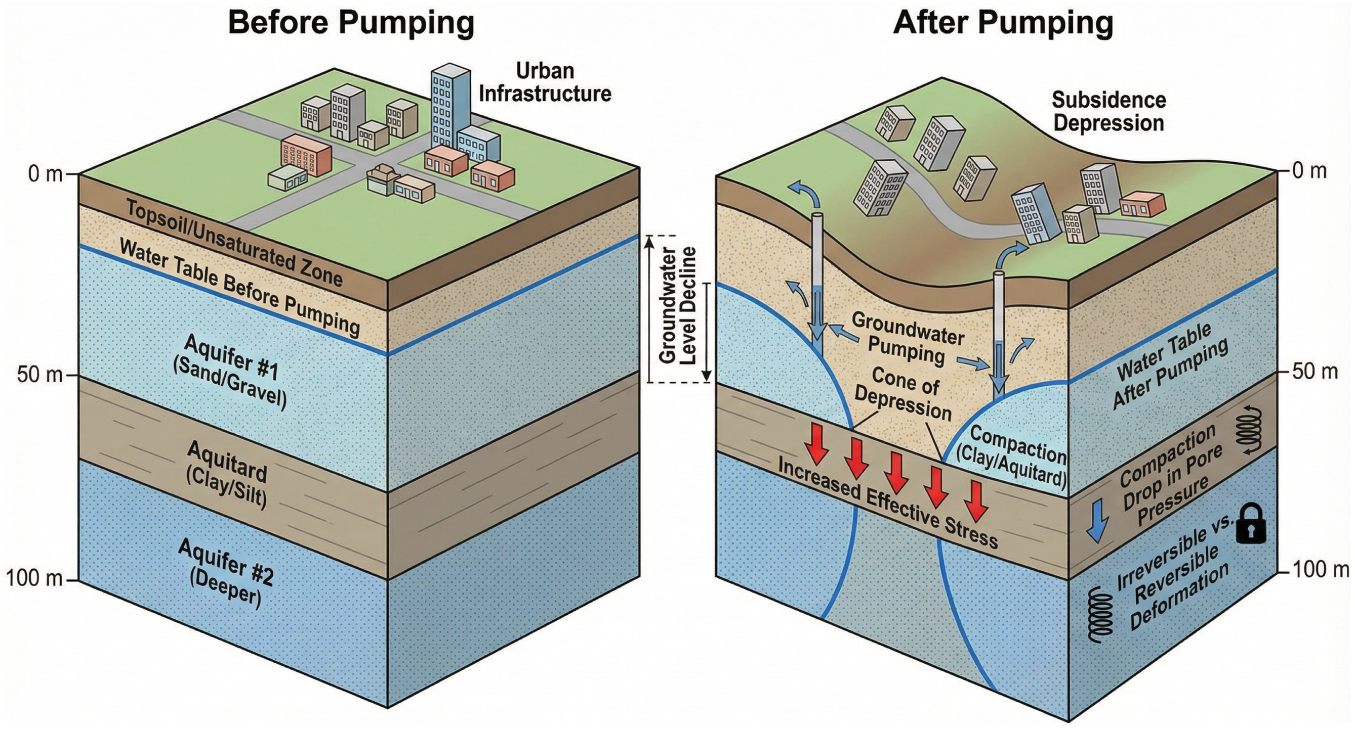
Land subsidence is primarily driven by hydrogeological processes that alter pore water pressure and increase effective stress within aquifer systems. Groundwater extraction, geological composition, recharge imbalance, and climate variability control the magnitude, rate, and reversibility of subsidence by influencing sediment compaction and aquifer stability [
4,
5,
20]. An illustration of the ground extraction is shown in
Figure 5. Understanding these drivers is essential for explaining subsidence mechanisms and developing effective mitigation strategies.
3.1.1. Groundwater Extraction and Pore Pressure Decline
Groundwater extraction is the most widely documented and dominant hydrogeological driver of land subsidence in urban aquifer systems. When pumping lowers hydraulic head, the resulting reduction in pore water pressure disrupts hydrostatic equilibrium and increases the effective stress borne by the soil matrix, initiating compaction in aquifers and aquitards [
4,
10]. According to Terzaghi’s effective stress principle, pore pressure decline directly translates into consolidation of fine-grained sediments, particularly clay-rich aquitards, which compress slowly due to their low permeability [
17,
19]. This process is irreversible mainly in clayey layers because their structure undergoes inelastic deformation once pore pressure drops below historical minima, whereas sandy aquifers may experience partial elastic rebound only if water levels recover [
15,
35]. The dominance of clay-rich aquitards in many Asian coastal plains makes them particularly sensitive to sustained pumping, where consolidation may continue for years even after abstraction declines.
Empirical observations support this mechanism. In the Pingtung Alluvial Plain (Taiwan), groundwater extraction is so widespread that approximately 90% of wells are unregistered, making actual abstraction volumes difficult to quantify [
36]. Despite relatively stable rainfall conditions, groundwater levels continue to decline, with Shih et al. (2019) demonstrating that recharge is insufficient to counteract pumping-induced drawdown, which in turn corresponds with mapped zones of active subsidence [
36]. This clear linkage between hydraulic head decline and surface deformation confirms the causal chain from pumping to pore pressure decline to sediment compaction. A similarly well-documented case is the Bandung Basin (Indonesia), where groundwater pumping began intensifying in the early 1900s and surged further with the establishment of textile industries after the 1970s. As much as 60% of Bandung’s total water demand is supplied by pumped groundwater [
37], leading to persistent cones of depression and land subsidence ranging from 5 to 75 cm between 2000 and 2008. Numerical and geodetic analyses estimate that 30–70% of the observed subsidence is directly attributable to groundwater drawdown. These examples highlight a consistent hydrogeological principle: when groundwater extraction exceeds natural recharge, pore pressures decline, effective stress increases, and the resulting compaction, especially in clay-rich aquitards, is predominantly permanent [
5,
7,
38]. As compaction reduces the thickness and porosity of compressible layers, the aquifer system loses storage capacity, making future recovery more difficult even under reduced pumping. This irreversibility transforms groundwater overexploitation into a long-term constraint on land stability, water security, and urban resilience.
3.1.2. Geological and Soil Characteristics
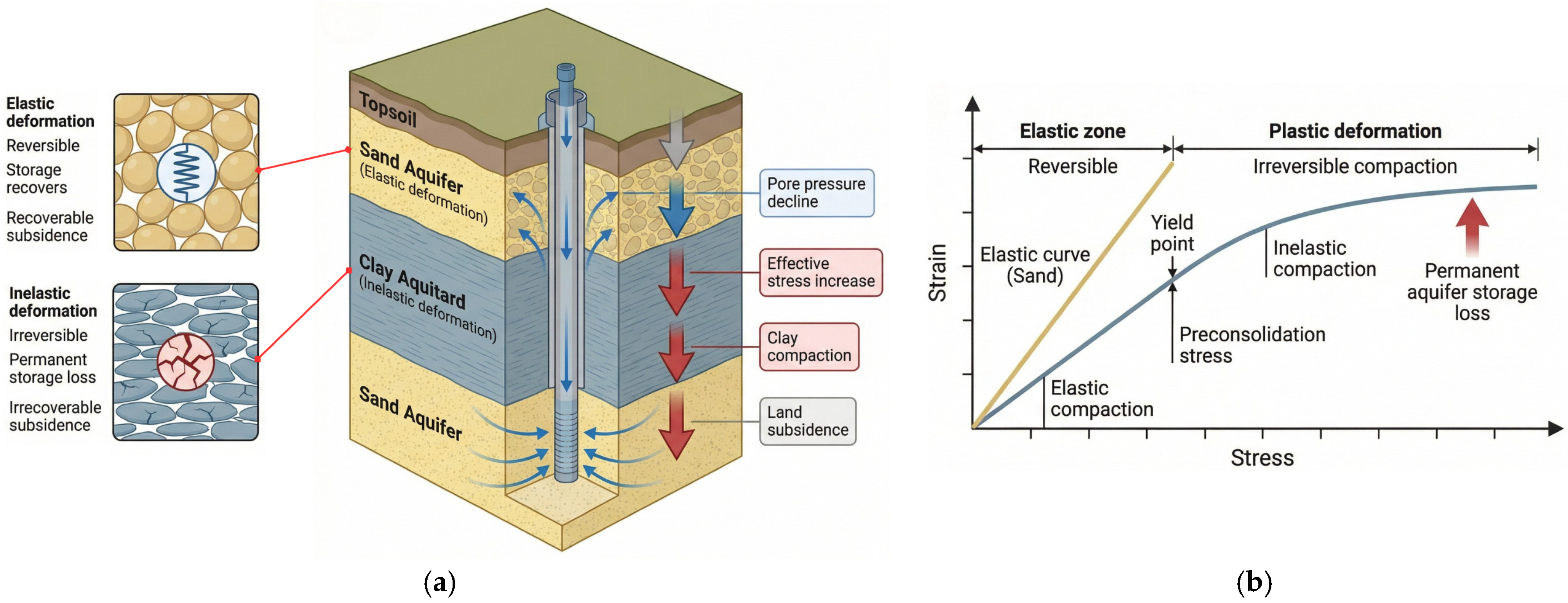
The geological framework of an aquifer system determines how strongly it responds to groundwater stress, making soil composition and stratigraphy fundamental controls on subsidence behavior (
Figure 6a). Fine-grained, clay-rich sediments, particularly Holocene clays deposited in coastal, deltaic, and lacustrine environments, are the most prone to compaction because of their low permeability and high compressibility (
Figure 6b). When pore pressure declines, these materials release water slowly, causing inelastic, permanent consolidation that directly contributes to long-term land subsidence [
19].
A clear example of this geological sensitivity is found in Mexico City, which is built on a thick sequence (up to several hundred meters) of soft volcanic silts and lacustrine clays. These highly compressible sediments have undergone dramatic consolidation as groundwater levels declined, producing cumulative subsidence exceeding 10 m in some locations, one of the most extreme cases globally [
39]. The thickness and softness of the Valley of Mexico’s clay layers explain why even moderate declines in hydraulic head translate into large vertical displacements, making geology, not pumping alone, the dominant factor in shaping the long-term subsidence trajectory. Similarly, in California’s San Joaquin Valley, deep, layered aquitards composed of fine-grained alluvium have compacted in response to prolonged agricultural pumping. Despite the presence of coarser alluvial fan sediments in some areas, the widespread interbedding of clays means that the valley behaves as a predominantly aquitard-governed system, exhibiting substantial inelastic compaction. Satellite and well-level data indicate that thick clay units have contributed to subsidence rates previously reaching over 300 mm/year, with much of the deformation deemed irreversible due to aquitard consolidation [
40,
41]. Another illustrative case is Venice, Italy, where Holocene lagoonal deposits, comprising soft silts, peats, and clays, have historically compacted under both natural consolidation and earlier groundwater withdrawals. Although groundwater pumping has since been curtailed, the compressibility of the lagoon sediments continues to drive residual subsidence, demonstrating how geological conditions exert influence even when direct human stressors are reduced [
42].
Across these settings, a consistent pattern emerges that aquifer systems dominated by thick, young, fine-grained sediments are inherently more susceptible to subsidence once pore pressures change. By contrast, regions with predominantly sandy or gravelly deposits may exhibit more elastic deformation and partial recovery, but these units are often interlayered with clays that ultimately govern long-term system behavior [
4]. Therefore, geology does not merely modulate subsidence; it dictates the magnitude, reversibility, and persistence of deformation once groundwater extraction begins.
3.1.3. Recharge Imbalance and Limited Natural Recovery
Recharge imbalance occurs when the volume of groundwater withdrawn from an aquifer exceeds the rate at which water naturally infiltrates back into the subsurface [
43]. This persistent deficit sustains or accelerates land subsidence, particularly in groundwater basins containing thick, low-permeability aquitards. Because these fine-grained layers drain extremely slowly, they cannot rapidly rebuild pore pressure once it declines, leading to prolonged and progressive consolidation even during periods of reduced pumping [
44,
45]. This delayed hydromechanical response—often termed aquitard drainage lag—has been widely documented in compacting aquifer systems, where subsidence continues for years or decades after extraction slows because pore water equilibration occurs over very long timescales. Such behavior underscores that the capacity for natural recovery is not controlled solely by rainfall or pumping reductions but by the intrinsic hydraulic diffusivity of the aquifer–aquitard system.
This lagged response—aquitard drainage lag—is one of the most important physical mechanisms explaining why many subsiding cities fail to stabilize despite reducing groundwater use. Compaction in aquitards can persist for years to centuries, as demonstrated in the San Joaquin Valley, where new modeling shows that residual compaction in fine-grained layers can continue for 64–1008 years after head declines, indicating that head stabilization alone is insufficient for recovery [
20]. This mechanism is also recognized globally, including in Mexico City, Bangkok, and Tianjin—cities where subsurface clays continue compacting long after peak pumping periods [
46]. Recharge imbalance is further intensified by urbanization, which reduces natural infiltration pathways. Impervious surfaces—roads, pavements, commercial blocks—greatly increase surface runoff while decreasing diffuse recharge. Studies show that rapidly urbanizing cities such as Guwahati and Dübendorf experience sharp declines in natural recharge due to soil sealing, even as leakage from water supply systems contributes some artificial recharge [
47]. However, in most cities, these leakage-driven recharge inputs are insufficient to offset the high rates of groundwater withdrawal.
In Southeast Asia specifically, chronic recharge deficits are a defining feature of major subsiding cities. In Semarang, natural recharge remains too low to counteract decades of overpumping, leading to annual subsidence rates of 24–36 cm and long-term economic losses exceeding USD 245 million [
48]. The same pattern is documented in Jakarta and Metro Manila, where declining recharge combined with excessive extraction has produced highly variable and spatially uneven deformation patterns—an issue that complicates policy and groundwater governance [
31]. Climatic variability further aggravates recharge imbalance. Drought years reduce effective precipitation and slow down the infiltration pulses needed to replenish deeper aquifers. Evidence from California, Mexico, and northern China shows that prolonged droughts significantly increase the depth and duration of head declines, triggering compaction that continues well into recovery periods [
46]. Because the storage loss resulting from inelastic compaction is irreversible, artificial recharge and managed aquifer recharge (MAR) have been widely explored as interventions. However, their effectiveness depends heavily on hydro stratigraphic conditions. In cities underlain by thick aquitards or deeply compacted basins, MAR can slow subsidence but cannot restore lost storage or reverse inelastic deformation [
4].
3.1.4. Climate-Related Influences on Ground Stability
Climate variability and long-term climate change significantly modulate the hydrogeological processes that govern land subsidence [
49]. Although groundwater extraction remains the primary anthropogenic driver, climatic factors—particularly drought, extreme rainfall, temperature increases, and sea-level rise—alter pore pressure regimes, soil moisture conditions, and sediment stability in ways that can both trigger and intensify ground deformation [
50]. Periods of prolonged drought reduce natural recharge, lower water tables, and increase effective stress within aquifer systems, accelerating the consolidation of fine-grained sediments. Studies of drought-impacted basins show that reduced rainfall infiltration substantially limits pressure recovery and intensifies inelastic compaction, especially in recharge-limited urban regions [
51]. Evidence from managed urban catchments further demonstrates that declining rainfall and rising temperatures shift hydrological balances toward higher evapotranspiration, diminishing available recharge and exacerbating subsidence in groundwater-dependent cities [
47].
Conversely, extreme rainfall events can destabilize unconsolidated sediments by rapidly increasing soil moisture and triggering localized failures. Intense precipitation enhances pore water buildup in shallow layers and can induce sudden collapses, sinkholes, or shallow compaction in karstic and alluvial environments. For example, sinkhole clusters documented after major storms in karst terrains show how rapid infiltration and transient pore pressure spikes can undermine ground stability [
52]. Similarly, in flood-prone deltas, storm-driven hydraulic loading amplifies vertical stress on already compacting soils, accelerating subsidence where sediments are waterlogged and weak [
53].
In high-latitude or cold regions, permafrost thaw represents a critical climate-related mechanism of ground instability. Rising temperatures increase talik formation and trigger thermokarst processes, ground collapse as ice-rich permafrost melts, leading to rapid and spatially heterogeneous subsidence. Farquharson et al. (2019) showed that warming-driven thermokarst development can cause surface lowering at rates far exceeding background subsidence, fundamentally altering hydrogeological pathways and drainage networks [
37,
54]. Permafrost degradation also modifies hydraulic conductivity and soil structure, promoting deeper thaw and long-term instability of built infrastructure [
55].
For coastal megacities, sea-level rise and tidal flooding interact with subsidence processes by raising groundwater levels in shallow aquifers, increasing pore water pressures, and altering sediment consolidation dynamics. In northern Manila Bay, for instance, global sea-level rise combines with anthropogenic subsidence to produce relative sea-level rise that is several times higher than global averages, intensifying flooding hazards and weakening ground stability [
13,
56]. Studies of coastal inundation similarly demonstrate that land subsidence amplifies the frequency and duration of tidal flooding, creating feedback loops between hydrodynamics, soil saturation, and ongoing deformation [
53]. So, climate-driven shifts in land–water interactions affect groundwater hydraulics in deltaic systems. Research on major Asian Mega deltas shows that altered monsoon patterns, sea-level-driven hydraulic gradients, and increased tidal reach intensify groundwater salinization, reduce recharge, and accelerate compaction of Holocene sediments [
57]. These studies emphasize that climate change not only modifies surface hydrology but also alters the long-term geomechanically stability of sedimentary basins.
3.2. Impacts of Land Subsidence
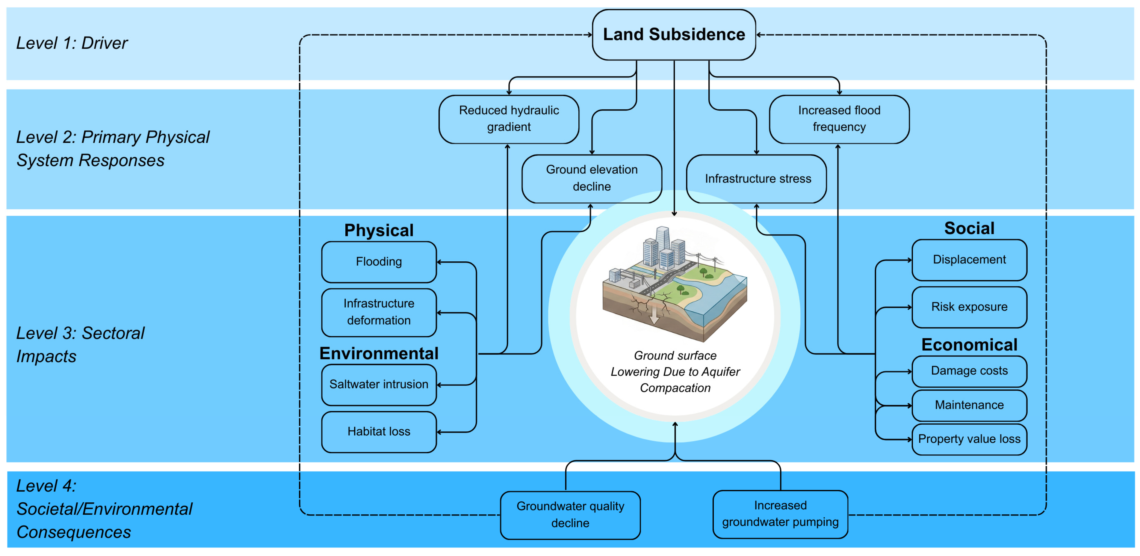
Land subsidence causes a chain of impacts that extends beyond ground lowering and directly affects urban systems, the environment, and society. As shown in
Figure 7, the physical deformation of the ground disrupts infrastructure, alters hydrological conditions, and increases flood risk, which in turn leads to economic losses, environmental degradation, and social vulnerability. These impacts are interconnected and often create feedback mechanisms that further accelerate subsidence and weaken urban resilience.
3.2.1. Physical Impacts: Flooding and Infrastructure Damage
Land subsidence directly intensifies physical hazards in urban environments by lowering ground elevation, deforming infrastructure, and altering natural drainage pathways [
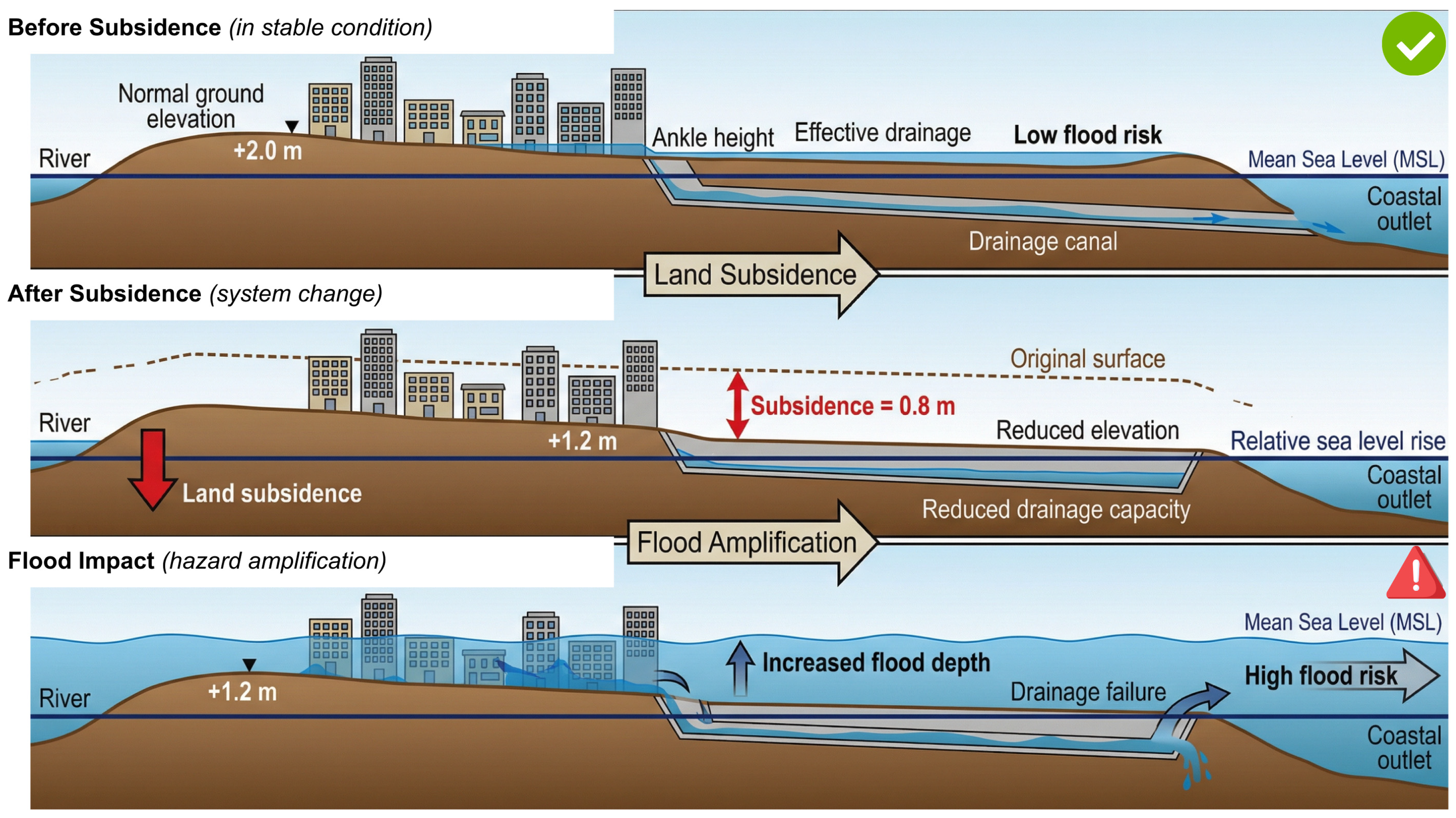
58]. The most immediate and widely documented consequence is increased flood susceptibility, especially in low-lying coastal and deltaic regions (see
Figure 8). As land surface elevations decline, the hydraulic gradient that drains runoff toward rivers, estuaries, or coastal waters is reduced, causing stormwater to accumulate more readily and persist for longer durations [
59]. Numerous studies emphasize that subsidence amplifies both pluvial (rainfall-driven) and tidal/coastal flooding, transforming moderate rainfall events into damaging inundations in cities where drainage systems were initially designed for higher ground levels [
6,
14,
60,
61].
A clear example comes from Semarang, Indonesia, where subsidence rates of 10–20 cm/year have dramatically altered flood dynamics. As documented in the systematic review of Semarang’s hazard evolution, subsidence has reduced freeboard on river levees, reversed drainage flows during high tides, and increased inundation depths in formerly protected zones [
48]. A cost–benefit assessment in Semarang and neighboring Demak further shows that land subsidence alone accounts for a significant proportion of economic flood losses, even before considering climate-driven sea-level rise [
57].
In Manila Bay, widespread anthropogenic subsidence has accelerated relative sea-level rise to rates far exceeding global averages. As shown by Rodolfo & Siringan (2006), areas around northern Manila Bay, particularly Bulacan and Pampanga, experience the combined effects of subsidence and coastal forcing, rendering large tracts of land increasingly prone to tidal flooding [
13]. Similar analyses demonstrate that even modest storm surges now produce extensive inundation in districts where elevation decline has erased natural protections [
62]. High-resolution inundation modeling further indicates that subsidence contributes more to present-day flood depths than eustatic sea-level rise, making it the dominant driver of coastal hazard escalation in the region [
63].
Subsidence also exerts profound impacts on infrastructure integrity. As the ground compacts unevenly, buildings, roads, bridges, pipelines, and rail systems experience differential settlement that strains structural components beyond design tolerances. In Bangkok, long-term monitoring shows that subsidence-induced tilting and cracking have damaged road pavements, distorted canal networks, and deformed foundations, adding substantial maintenance burdens to the city’s infrastructure systems [
7,
10]. Similar patterns are observed in Jakarta, where decades of rapid urban development atop compressible alluvium have caused widespread building deformation and service line disruption [
7].
The impacts extend to lifeline systems as well. Studies from the United States show that even small amounts of subsidence can fracture buried water and sewer pipelines, distort storm-drain gradients, and trigger failures of levees and floodwalls that rely on stable ground elevation [
64]. In deltaic settings, deformation of earthen embankments increases the risk of overtopping and breach, complicating flood risk management under climate change scenarios [
65].
Furthermore, subsidence alters groundwater–surface water interactions, reducing the effectiveness of existing drainage systems [
66]. As drainage canals, culverts, and outfalls sink relative to receiving waters, they lose hydraulic capacity, causing backflow during high tides or intense rainfall [
60]. This mechanism has been demonstrated in multiple coastal megacities, where subsidence transforms gravity-drained systems into pump-dependent infrastructure [
55].
3.2.2. Economic Impacts
Land subsidence generates substantial economic losses by increasing flood damage, degrading infrastructure, and raising the cost of urban services. As ground levels drop, flood frequency and severity increase, leading to more serious damage to homes, businesses, and public facilities [
67]. In Semarang and Demak, subsidence contributes directly to millions of dollars in annual flood losses, even before accounting for future sea-level rise [
48,
57]. Similar findings in the Mekong Delta show that subsidence-related flooding drives significant economic losses in agriculture and urban infrastructure [
68]. Subsidence also increases maintenance and repair costs for buildings, roads, bridges, and utility networks. In Bangkok, persistent settlement has caused cracking of pavements, deformation of canals, and recurring repair expenses for public works. Jakarta faces similar costs as differential settlement damages, building foundations, and disrupted service lines [
7].
Critical lifeline systems, water pipelines, sewers, and power conduits are susceptible to ground deformation. Even minor subsidence can distort gradients, reduce flow, and cause structural failures, as documented across major U.S. cities [
69,
70]. In California’s Central Valley, subsidence has impaired the operation of aqueducts, affecting multimillion-dollar water deliveries [
41]. Coastal cities bear additional economic burdens because subsidence increases the cost of flood protection. In Manila Bay, relative sea-level rise driven by subsidence requires continuous raising of seawalls and pumping infrastructure, significantly increasing long-term adaptation costs [
13,
62]. Global analyses indicate that subsiding deltas may face 100–300% higher protection costs compared with regions experiencing sea-level rise alone [
14].
Subsidence also reduces land and property values, particularly in areas experiencing chronic flooding or repeated infrastructure failures. In Semarang, declining elevation has discouraged investment and lowered property prices in affected districts [
48]. In agricultural regions, soil salinization and reduced freshwater availability driven by subsidence diminish crop yields and economic productivity [
71]. Finally, long-term groundwater storage loss imposes economic pressures by forcing cities to rely on costly alternative water sources such as desalination and inter-basin transfers [
6,
25].
3.2.3. Social Impacts
Land subsidence produces severe social consequences by displacing communities, disrupting livelihoods, and increasing human vulnerability to environmental hazards. As ground elevation declines, flood frequency and duration increase, forcing residents to abandon homes and relocate to safer areas. This process has been widely documented in coastal and deltaic cities, where subsidence accelerates relative sea-level rise and renders previously habitable land unsuitable for settlement [
13,
62]. In Jakarta, continuous subsidence has contributed to widespread residential displacement and forced relocation of vulnerable communities, particularly in low-lying coastal districts where chronic flooding has become unavoidable [
7,
48]. Similarly, in northern Manila Bay, subsidence has progressively submerged residential zones, threatening long-term habitability and forcing communities to adapt through elevation of homes or relocation [
11,
13].
Subsidence also disrupts livelihoods, particularly in regions dependent on agriculture, fisheries, and coastal economic activities [
72]. In the Mekong Delta, land subsidence has increased salinity intrusion and flood frequency, reduced agricultural productivity, and undermined the economic security of farming communities [
65]. Loss of productive land and infrastructure further compounds socio-economic vulnerability, particularly where populations lack the financial capacity to recover or relocate [
25,
31]. In many rapidly urbanizing areas, subsidence alters land usability, forcing residents to incur additional costs for flood protection, house elevation, or relocation, which disproportionately affects economically disadvantaged populations.
Beyond physical displacement and economic disruption, subsidence also generates significant psychological and social stress. Communities exposed to repeated flooding and infrastructure damage experience chronic anxiety, uncertainty, and reduced quality of life [
73,
74]. Persistent flood threats, property loss, and uncertainty about future safety contribute to emotional distress and long-term mental health impacts, particularly among vulnerable populations with limited adaptive capacity [
75,
76]. These effects are compounded by social inequality, as low-income households are more likely to reside in subsidence-prone areas with weaker infrastructure and limited access to mitigation measures [
76,
77]. Also, subsidence contributes to long-term loss of habitable land, reducing urban livability and increasing population pressure in safer areas. Global assessments show that subsidence significantly accelerates coastal land loss and threatens the sustainability of major deltaic cities worldwide [
6,
53,
78]. This progressive loss of land and security highlights the profound social implications of subsidence, extending beyond environmental degradation to affect human settlement patterns, social stability, and long-term urban resilience.
3.2.4. Environmental Impacts
Land subsidence produces severe environmental consequences by accelerating relative sea-level rise (RSLR) [
79], degrading groundwater quality, permanently reducing aquifer storage, and destabilizing ecosystems. One of the most critical effects is the acceleration of RSLR, where land surface lowering compounds the impact of global sea-level rise. In many deltaic and coastal regions, subsidence contributes more to elevation loss than climate-driven ocean rise alone [
6]. In Manila Bay, subsidence rates exceeding 10 mm/year have significantly increased coastal flood exposure, far surpassing global mean sea-level rise rates of approximately 3 mm/year [
11,
13]. Subsidence also contributes to saltwater intrusion, which threatens freshwater availability and water security. As land sinks and groundwater pressure declines, saline water migrates inland and upward into freshwater aquifers, contaminating drinking water sources and reducing agricultural productivity [
53,
80]. This process has been widely observed in coastal megacities and delta regions, including Southeast Asia, where groundwater over-extraction and subsidence jointly accelerate aquifer salinization [
81].
Another environmental impact is the permanent loss of aquifer storage capacity caused by irreversible compaction of compressible sediments. When aquifer systems collapse under increased effective stress, pore spaces are permanently reduced, limiting their ability to store and transmit water in the future [
4,
20]. Global assessments estimate that subsidence contributes to significant long-term groundwater storage losses, reducing the sustainability of groundwater resources and forcing increased reliance on alternative water sources [
25].
Subsidence also drives ecosystem degradation, particularly in coastal wetlands and delta environments. As land sinks, wetlands, mangroves, and estuarine habitats become permanently submerged or eroded, resulting in habitat loss, biodiversity decline, and reduced natural coastal protection [
82,
83]. Large delta systems such as the Mississippi River Delta have experienced extensive wetland loss due to the combined effects of subsidence and sea-level rise, illustrating the long-term ecological consequences of land elevation decline [
6,
84]. These environmental impacts demonstrate that land subsidence is not only a geotechnical or hydrological problem but also a threat to ecosystem stability, freshwater security, and long-term ecological sustainability.
3.3. Global Case Studies: Spatial Patterns and Severity (Asian Megacities)
Across Asia’s major coastal megacities, land subsidence shows strongly clustered “hotspots” rather than uniform sinking, because drawdown, stratigraphy, and loading vary sharply over short distances. In most cases, the dominant control is groundwater withdrawal, which lowers pore pressure, increases effective stress, and drives consolidation, especially in thick, clay-rich aquitards, where compaction becomes largely irreversible.
Jakarta exhibits high spatial and temporal variability, with commonly reported rates on the order of ~1–15 cm/yr and localized peaks reaching ~20–28 cm/yr in some periods/areas, based on geodetic measurements (leveling/GPS/InSAR) [
85]. The superposition of multiple drivers explains these patterns: (i) intensive groundwater abstraction that depressurizes aquifers [
86], (ii) loading from dense construction on compressible deposits [
87], (iii) natural consolidation of young alluvium [
88], and (iv) tectonic contributions in parts of the basin [
89]. Recent governance-focused work also emphasizes that subsidence in Jakarta is not only a hydrogeologic process but also a product of uneven urban development and water access systems that perpetuate reliance on groundwater in many districts [
90].
In Ho Chi Minh City, subsidence is typically concentrated along the Saigon River corridor and fast-growing districts, where withdrawal and rapid construction intensify ground response. Sentinel-1/ALOS-based studies report high local subsidence values reaching ~80 mm/yr in the most affected zones, with strong spatial structure rather than citywide uniform rates [
91]. Importantly, mapping studies show that the most severe deformation commonly overlies Holocene loam/silt-loam and other young deltaic deposits, which are mechanically prone to consolidation when pore pressure declines. The takeaway for your synthesis is that HCMC is a clear example of “sediment-controlled vulnerability”: where thick, fine-grained sequences exist, even moderate drawdown or loading can translate to significant vertical motion [
90].
Bangkok’s classic subsidence mechanism is pumping-induced consolidation in a layered aquifer–aquitard system, where thick, compressible clays govern long-term settlement. Long records indicate considerable cumulative subsidence, with estimates increasing from about ~1.60 m (1933–1987) to ~2.05 m by 2002 in parts of the metropolitan area as additional observations accumulated [
10]. More recent assessments emphasize that even when pumping is reduced, delayed drainage and ongoing consolidation in clay aquitards can sustain subsidence trends (lag effects), reinforcing the need for sustained groundwater governance rather than short-term pumping cuts [
10,
92].
Tokyo provides Asia’s most cited “reversal” case. Intensive post-war groundwater pumping rose through the mid-20th century, with reported withdrawals reaching ~1.5 million m
3/day around 1970, coinciding with severe subsidence in low-lying deltaic wards [
8]. Following decisive regulation (limits/prohibitions on industrial pumping) and the development of alternative water supplies, groundwater levels recovered, and subsidence rates fell dramatically; later-stage rates in the most affected zones are commonly reported as ~1 cm/yr order rather than the earlier extreme values. Tokyo demonstrates that (1) [
93] subsidence can be policy-sensitive and (2) the most effective pathway is often a structural shift away from groundwater dependence, not only technical monitoring [
8].
For the Philippines, a recent nationwide InSAR-based assessment reports a maximum subsidence rate of ~109 mm/yr in Bulacan (Greater Manila area), with additional subsidence signals documented in other metropolitan regions [
94]. Detailed Metro Manila deformation studies show that subsidence “troughs” spatially correspond to areas of intensive groundwater extraction and drawdown, supporting the interpretation that groundwater cones of depression are a first-order predictor of where sinking concentrates [
95]. Manila Bay studies further argue that the combined effect of anthropogenic subsidence + coastal forcing substantially increases flood exposure and relative sea-level rise impacts, particularly around northern Manila Bay [
13]. Finally, governance analyses for Southeast Asia highlight why progress can stall even when technical solutions exist: fragmented mandates and uneven water access can keep cities locked into groundwater dependence [
31].
3.4. Effectiveness of Mitigation Strategies
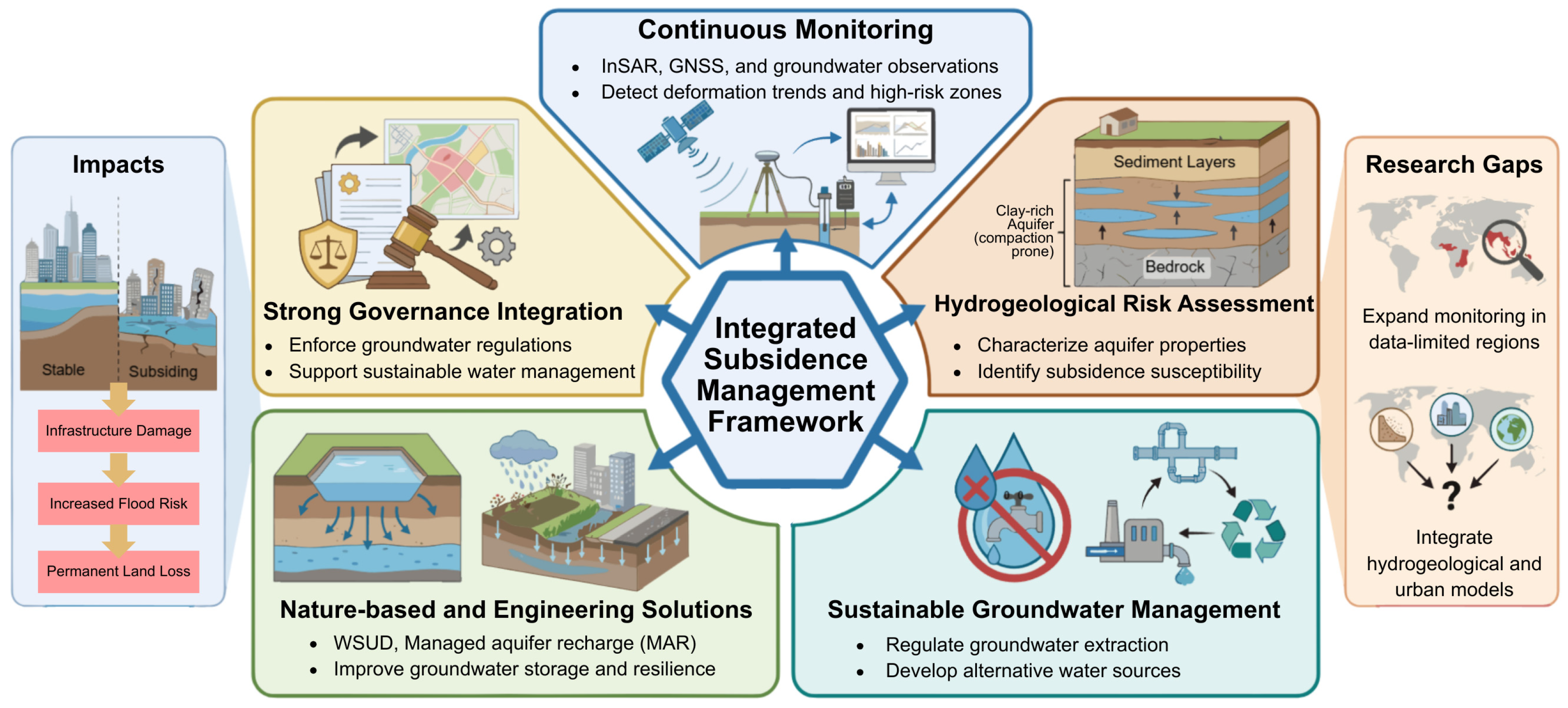
Mitigation strategies aim to slow, stop, or manage land subsidence by addressing its root causes and reducing its impacts. As shown in
Figure 9, effective subsidence management requires an integrated approach that combines monitoring, sustainable groundwater management, engineering measures, nature-based solutions, and strong governance. These strategies work together to restore groundwater balance, protect infrastructure, and improve long-term urban resilience.
3.4.1. Groundwater Regulation
Groundwater regulation has proven to be one of the most effective strategies for mitigating land subsidence by restoring aquifer pressure and reducing sediment compaction. Tokyo represents the most successful example, where strict groundwater extraction controls implemented in the 1960s, including industrial pumping restrictions and the development of alternative surface water supplies, led to substantial groundwater level recovery and a dramatic reduction in subsidence rates from more than 20 cm/year to approximately 1 cm/year in recent decades [
4,
8]. Similar success has been observed in Bangkok, Thailand, where government-imposed licensing systems, groundwater abstraction fees, and pumping restrictions significantly reduced groundwater extraction and slowed subsidence rates after decades of severe land sinking exceeding two meters cumulatively [
10,
96]. Shanghai, China, also demonstrates the effectiveness of regulatory control, where the establishment of groundwater withdrawal control zones, combined with artificial recharge and continuous monitoring, reduced subsidence rates and stabilized ground conditions in several urban districts [
27]. In Beijing, the introduction of strict groundwater management policies and the implementation of the South-to-North Water Diversion Project contributed to groundwater recovery and the mitigation of subsidence by reducing reliance on aquifers for urban water supply [
97]. However, the effectiveness of groundwater regulation depends heavily on enforcement and the availability of alternative water sources. In Jakarta, despite the introduction of groundwater extraction regulations, subsidence continues due to weak enforcement, illegal pumping, and continued dependence on groundwater, highlighting that regulatory frameworks must be supported by strong governance and reliable alternative water supply systems to achieve long-term mitigation success [
7,
31]. These global experiences demonstrate that groundwater regulation, when properly enforced and integrated with sustainable water management strategies, can significantly reduce subsidence and improve long-term urban resilience.
3.4.2. Managed Aquifer Recharge (MAR)
Managed aquifer recharge (MAR) has emerged as one of the most effective technical solutions for mitigating land subsidence by restoring groundwater levels, increasing pore pressure, and slowing or reversing aquifer compaction [
28]. Shanghai provides one of the most successful examples, where large-scale artificial recharge programs initiated in the 1960s significantly reduced subsidence rates from approximately 12.7 mm/year to about 1.3 mm/year following sustained groundwater reinjection and strict groundwater regulation [
27,
98]. Similarly, in Beijing, the combined implementation of MAR and the South-to-North Water Diversion Project resulted in substantial groundwater recovery and measurable land uplift in approximately 47% of monitored areas, demonstrating the effectiveness of recharge-based mitigation in reversing long-term aquifer depletion [
97,
99].
Other major cities have achieved similar success using MAR. In Tokyo, artificial recharge combined with groundwater withdrawal restrictions led to widespread groundwater recovery and stabilization of previously subsiding areas, significantly reducing subsidence rates since the 1970s [
4,
8]. In Orange County, California, USA, one of the world’s largest MAR systems, the Groundwater Replenishment System, has successfully restored groundwater levels, preventing further land subsidence while providing a sustainable urban water supply [
100,
101]. In the Netherlands, MAR has been widely used to maintain groundwater balance in low-lying coastal regions, helping prevent subsidence and saltwater intrusion while supporting long-term water security [
102,
103]. Bangkok has also implemented artificial recharge and groundwater management programs, contributing to groundwater level stabilization and reduced subsidence rates after decades of severe land sinking [
10,
104].
These global experiences demonstrate that MAR can effectively mitigate subsidence when implemented alongside groundwater regulation and sustainable water management. By restoring aquifer pressure and reducing irreversible sediment compaction, MAR not only slows land subsidence but also improves groundwater availability, enhances drought resilience, and strengthens long-term urban sustainability [
18,
99]. However, the long-term success of MAR depends on careful management, including water quality control, monitoring of aquifer response, and integration with broader water resource management strategies.
3.4.3. Water-Sensitive Urban Design (WSUD)
Water-Sensitive Urban Design (WSUD) is increasingly recognized as a sustainable strategy to mitigate land subsidence by enhancing natural groundwater recharge and improving stormwater management [
105]. WSUD integrates decentralized green infrastructure such as permeable pavements, infiltration basins, rain gardens, and vegetated swales to promote local infiltration and reduce surface runoff. These systems help restore groundwater balance by allowing stormwater to infiltrate into shallow aquifers, reducing dependence on groundwater extraction and minimizing aquifer compaction [
18,
24]. By restoring natural hydrological pathways disrupted by urbanization, WSUD contributes to long-term groundwater sustainability and subsidence mitigation.
Several cities have successfully implemented WSUD to enhance groundwater recharge and urban resilience. In Singapore, the ABC Waters Program integrates bio-retention systems, constructed wetlands, and infiltration features that improve stormwater retention and enhance local recharge while reducing urban flood risk [
106,
107]. Similarly, Rotterdam, Netherlands, has implemented water plazas, green roofs, and infiltration parks to store and gradually infiltrate stormwater, helping maintain groundwater levels in low-lying subsidence-prone areas [
108,
109]. These systems demonstrate how WSUD can simultaneously address flooding, groundwater depletion, and subsidence risk.
In Asian megacities, WSUD is increasingly applied to complement groundwater management programs. In Shanghai, green infrastructure and infiltration systems have been incorporated into urban planning to support groundwater recovery and reduce subsidence alongside artificial recharge efforts [
27]. In Tokyo, permeable pavements, infiltration trenches, and rainwater harvesting systems have helped maintain groundwater recharge and contributed to stabilizing land elevation following decades of severe subsidence [
8]. Similarly, Jakarta has promoted infiltration wells and green open spaces to enhance groundwater recharge and reduce subsidence, although effectiveness depends on proper implementation and large-scale adoption [
110].
WSUD provides a practical, nature-based solution that enhances aquifer recharge, improves stormwater management, and supports long-term subsidence mitigation. When integrated with groundwater regulation and managed aquifer recharge programs, WSUD can significantly improve groundwater sustainability and urban resilience in subsidence-prone cities [
18,
24].
3.4.4. Geotechnical Approaches
Geotechnical engineering solutions play a critical role in mitigating land subsidence and differential settlement by improving soil strength, reducing compressibility, and stabilizing foundations in subsidence-prone areas [
111]. Traditional techniques such as dynamic compaction, deep soil mixing, and optimized foundation design are widely used to densify loose sediments and improve load-bearing capacity. These methods increase soil stiffness and reduce settlement under structural loads, particularly in urban environments built on soft alluvial and reclaimed land [
112]. Improved foundation systems, including pile foundations and raft foundations, are also effective in transferring loads to deeper, more stable strata, thereby minimizing differential settlement and structural damage [
113].
More recently, bio-mediated soil improvement techniques, such as Microbially Induced Calcite Precipitation (MICP), have emerged as innovative and sustainable approaches to subsidence mitigation [
114]. MICP strengthens soil by stimulating microbial processes that precipitate calcium carbonate, which binds soil particles together and reduces compressibility. Laboratory and field studies have demonstrated that MICP can significantly improve soil strength and stiffness while lowering settlement potential in soft soils [
115,
116]. Similarly, biopolymer-based soil stabilization, using materials such as xanthan gum and guar gum, has shown strong potential to enhance soil cohesion, reduce permeability, and improve resistance to deformation, offering environmentally friendly alternatives to traditional chemical stabilizers [
116,
117].
These geotechnical approaches have been successfully applied in subsidence-prone urban areas worldwide. For example, deep soil mixing and ground improvement techniques have been widely used in Japan and the Netherlands to stabilize soft clay foundations and reduce settlement risks in infrastructure projects [
118,
119]. In coastal and reclaimed urban zones, such as parts of Shanghai and Tokyo, improved foundation design combined with soil stabilization has significantly reduced structural damage caused by subsidence and ground deformation [
3,
4]. Geotechnical stabilization provides essential engineering solutions that complement groundwater management and urban planning strategies, helping protect infrastructure and improve long-term resilience in subsidence-affected regions [
120].
3.4.5. Advanced Monitoring Technologies
Advanced monitoring technologies have become essential tools for detecting, quantifying, and forecasting land subsidence with high spatial and temporal accuracy [
121]. Among these, Interferometric Synthetic Aperture Radar (InSAR) [
95,
122] and its advanced form, Persistent Scatterer InSAR (PSI-InSAR) [
90], are widely used because they can measure ground deformation at millimeter-scale precision over large areas. These satellite-based techniques enable continuous monitoring of subsidence patterns, identification of localized hotspots, and assessment of long-term deformation trends, even in densely populated urban environments [
29,
30]. In major subsiding cities such as Jakarta, Shanghai, and Metro Manila, PSI-InSAR has successfully mapped detailed deformation patterns and revealed strong spatial correlations between subsidence, groundwater extraction, and urban loading [
7,
11].
Global Navigation Satellite Systems (GNSS) provide highly accurate point-based measurements that complement satellite remote sensing by delivering continuous, real-time monitoring of vertical land motion [
121,
123]. GNSS observations are particularly valuable for validating InSAR results and detecting rapid deformation events that may not be captured by periodic satellite observations [
124]. Meanwhile, Light Detection and Ranging (LiDAR) technology provides high-resolution elevation data that enables detailed topographic analysis and detection of subtle elevation changes over time [
125,
126]. When integrated with InSAR and GNSS, LiDAR improves subsidence assessment accuracy and supports infrastructure risk evaluation and flood modeling [
127,
128,
129,
130,
131].
The integration of these technologies into multi-sensor monitoring systems has significantly improved subsidence forecasting and urban planning capabilities. For example, in the Mekong Delta and Shanghai, combined InSAR and GNSS monitoring has enabled early detection of high-risk subsidence zones and supported groundwater management and infrastructure protection strategies [
5,
9,
132]. These advanced monitoring systems provide essential data for sustainable land management by enabling early warning, improving predictive modeling, and supporting evidence-based decision-making. As subsidence risks continue to increase under rapid urbanization and climate change, integrated monitoring using InSAR, GNSS, and LiDAR will remain critical for protecting infrastructure, managing groundwater resources, and improving long-term urban resilience.
4. Discussion and Future Direction
4.1. Integrated Understanding of Hydrogeological Drivers and Urban Vulnerability
This review confirms that land subsidence is primarily driven by groundwater extraction, geological compressibility, and recharge imbalance, with urbanization acting as a critical amplifying factor. Groundwater withdrawal reduces pore pressure and increases effective stress, causing irreversible consolidation of aquitards and long-term elevation loss [
20,
86]. Recent satellite-based global assessments show that subsidence affects more than 20% of the world’s major cities, with Asia experiencing the highest rates due to rapid urbanization and groundwater dependence [
70,
133].
Urban expansion further intensifies subsidence by increasing groundwater demand while simultaneously reducing natural recharge through impervious surface development [
31]. This imbalance creates persistent groundwater depletion and long-term compaction, particularly in deltaic and coastal environments composed of highly compressible Holocene sediments [
5,
133]. Climate change introduces additional complexity by altering precipitation patterns, increasing drought frequency, and accelerating relative sea-level rise, all of which exacerbate subsidence impacts and urban flood risk [
14,
134]. Recent studies emphasize that subsidence now contributes more to relative sea-level rise in many coastal megacities than ocean rise alone, significantly increasing infrastructure vulnerability and disaster risk [
6,
70].
4.2. Limitations of Current Mitigation Strategies
Despite advances in subsidence mitigation, significant limitations remain in current management approaches. Groundwater regulation has successfully reduced subsidence in cities such as Tokyo and Shanghai, yet its effectiveness depends heavily on enforcement and availability of alternative water sources [
8,
135]. In many developing regions, weak governance, population growth, and water supply limitations continue to drive groundwater dependence, preventing effective mitigation [
31]. MAR has shown promise in stabilizing groundwater levels and reducing subsidence rates, but recent studies highlight that MAR cannot reverse inelastic compaction once aquifer systems collapse [
18,
28]. Similarly, geotechnical stabilization methods can protect individual structures but do not address regional subsidence driven by hydrogeological processes [
119]. Furthermore, monitoring systems remain insufficient in many high-risk regions, limiting early detection and effective management [
30]. These findings highlight the need for integrated subsidence management strategies combining hydrogeological assessment, urban planning, and long-term water resource sustainability.
4.3. Future Research Directions
Recent research emphasizes the urgent need for integrated modeling approaches that combine groundwater flow, sediment compaction, climate variability, and urban development. Most current subsidence models focus primarily on groundwater hydraulics without fully incorporating geomechanically processes, limiting their ability to predict long-term deformation accurately [
20,
136]. Advances in satellite remote sensing, particularly InSAR, provide unprecedented opportunities for global subsidence monitoring. Recent high-resolution satellite analyses have enabled subsidence detection at millimeter-scale accuracy, improving understanding of spatial variability and subsidence drivers [
2,
30]. However, integration of satellite data with hydrogeological and geotechnical models remains limited and represents a key area for future research [
122,
137].
Climate change introduces additional uncertainty, and future studies must evaluate how changing precipitation, drought frequency, and sea-level rise will influence subsidence processes. Recent global climate assessments show that groundwater depletion and subsidence are expected to increase significantly under future climate scenarios, particularly in rapidly urbanizing regions [
70].
4.4. Toward a Global Framework for Sustainable Land Subsidence Management: Strategic Recommendations for Stakeholders
Land subsidence cannot be effectively managed through isolated technical solutions. Evidence from subsiding cities worldwide shows that successful mitigation depends on a coordinated framework that integrates monitoring, hydrogeological understanding, water management, urban design, and governance. Cities that implemented only engineering solutions without addressing groundwater extraction have continued to subside, whereas cities that combined monitoring, regulation, and sustainable water supply achieved long-term stabilization [
5,
133]. This demonstrates that subsidence management must focus on controlling its root cause, groundwater imbalance, while simultaneously reducing urban vulnerability. To the best of our knowledge, previous studies have typically addressed land subsidence mitigation through individual technical or policy approaches, such as groundwater regulation, monitoring technologies, or engineering stabilization. However, a comprehensive framework integrating hydrogeological assessment, continuous monitoring, sustainable groundwater management, engineering and nature-based solutions, and governance coordination has rarely been synthesized in a single conceptual model. Therefore, this review proposes an integrated framework that combines these components to support more effective and sustainable management of land subsidence in rapidly urbanizing regions. Therefore, a proposed framework shown in
Figure 10 regarding sustainable land subsidence management is formed in five (5) core components.
The first component of the framework is continuous and integrated monitoring. Satellite-based InSAR, supported by GNSS and groundwater observation wells, provides accurate and large-scale measurements of land deformation and aquifer response [
131,
138]. These tools allow subsidence to be detected early, long before damage becomes visible at the surface. Early detection is critical because aquifer compaction becomes irreversible once certain thresholds are exceeded, making prevention far more effective than recovery [
20]. Monitoring data also provides the scientific basis for groundwater regulation, infrastructure planning, and risk assessment [
139].
The second component is hydrogeological risk assessment. Subsidence does not occur uniformly but is strongly controlled by aquifer characteristics, sediment composition, and recharge conditions [
4,
6]. Aquifers composed of young, fine-grained sediments, particularly in delta and coastal environments, are highly vulnerable to permanent compaction under groundwater stress [
14]. Understanding these subsurface conditions allows subsidence-prone zones to be identified and prioritized for protection. Without this hydrogeological foundation, mitigation efforts remain reactive and incomplete.
The third component is sustainable groundwater management, which is the most effective and proven solution for reducing subsidence. Global experience clearly shows that subsidence slows or stops when groundwater extraction is reduced, and alternative water sources are developed [
5,
9]. Surface water supply, wastewater reuse, desalination, and managed aquifer recharge all reduce dependence on groundwater and allow aquifer systems to stabilize [
18]. However, recovery is limited once aquifer systems are permanently compacted, reinforcing the importance of early intervention and preventive management [
20].
The fourth component is the integration of nature-based and engineering solutions to increase urban resilience. Recharge-enhancing infrastructure, such as infiltration systems and permeable surfaces, improves groundwater balance and reduces long-term stress on aquifers [
18,
24]. Engineering measures, including foundation reinforcement and ground improvement, can reduce infrastructure vulnerability in subsiding areas but cannot replace groundwater management [
118,
119]. These approaches are most effective when applied as part of a broader strategy that addresses both the cause and consequences of subsidence.
The fifth and most critical component is governance integration. Subsidence is ultimately driven by human decisions about water use, urban development, and environmental management. Cities that established strong groundwater regulation, monitoring programs, and long-term water planning have successfully reduced subsidence, while those without effective governance continue to experience severe ground deformation [
70]. Effective management requires coordination between water agencies, urban planners, engineers, and policymakers to ensure that groundwater use remains within sustainable limits.
This framework emphasizes prevention, early detection, and sustainable groundwater balance as the foundation of subsidence management. Monitoring provides the warning system, hydrogeological assessment identifies vulnerability, groundwater management addresses the root cause, engineering and nature-based solutions reduce impacts, and governance ensures long-term sustainability. Together, these components form a comprehensive and globally applicable strategy for managing land subsidence and protecting urban environments [
140].
5. Conclusions
Land subsidence is a growing global problem driven mainly by unsustainable groundwater extraction. When groundwater levels decline, pore pressure drops, and compressible sediments compact, causing permanent ground lowering. This process is especially severe in cities built on clay-rich coastal and deltaic deposits, where subsidence continues even after pumping is reduced. Recharge imbalance, rapid urbanization, and climate variability further worsen the problem by limiting natural recovery and increasing stress on aquifer systems. The consequences are severe and long-lasting. Subsidence increases flood risk, damages infrastructure, reduces groundwater storage, and weakens urban resilience. Evidence from major subsiding cities such as Jakarta, Bangkok, and Metro Manila shows that subsidence amplifies the impacts of sea-level rise and flooding, making cities more vulnerable to climate-related hazards.
This review confirms that the most effective solution is sustainable groundwater management. Reducing groundwater extraction, improving recharge, and developing alternative water sources are essential to stop further land loss. Monitoring systems, nature-based solutions, and engineering measures can support mitigation, but they cannot fully reverse subsidence once irreversible compaction occurs. The proposed integrated framework highlights that prevention, early monitoring, and strong governance are key to managing subsidence. Ultimately, land subsidence is a human-driven problem, and its future depends on how groundwater resources are managed today. With proper planning and coordinated action, cities can reduce subsidence and protect their long-term sustainability. Despite the comprehensive synthesis presented in this review, several limitations should be acknowledged. First, the findings depend on the availability and quality of existing primary studies, which vary significantly in terms of methodology, spatial coverage, and monitoring techniques. Second, the review may be subject to publication bias, as studies reporting significant subsidence impacts are more likely to be published than those reporting limited or insignificant effects. Third, the included studies exhibit methodological heterogeneity, particularly in the measurement of subsidence rates using different approaches such as leveling, GNSS, and InSAR, which may influence reported magnitudes and comparability across regions. Finally, although multiple scientific databases and reference screening were used, it is possible that some relevant publications were not captured due to language restrictions or database coverage. Future research would benefit from standardized monitoring frameworks, improved global datasets, and more integrated modeling approaches to better understand and manage land subsidence under changing environmental and urban conditions.
Author Contributions
Conceptualization, C.E.M., S.A.K., M.C.D.A., E.J.K., C.R.M.E. and J.G.; methodology, M.C.D.A. and J.G.; software, B.Q.N. and J.G.; validation, B.Q.N., J.G. and C.E.M.; formal analysis, J.G.; investigation, M.C.D.A., E.J.K. and C.R.M.E.; resources, B.Q.N. and S.A.K.; data curation, M.C.D.A., E.J.K., C.R.M.E. and J.G.; writing—original draft preparation, M.C.D.A., E.J.K. and C.R.M.E.; writing—review and editing, J.G.; visualization, J.G.; supervision, C.E.M., B.Q.N. and S.A.K.; project administration, C.E.M., B.Q.N. and S.A.K.; funding acquisition, C.E.M., B.Q.N. and S.A.K. All authors have read and agreed to the published version of the manuscript.
Funding
This work was supported by the Japan Science and Technology Agency (JST) under the NEXUS Program (Grant Number JPMJNX24A2). Support was also provided by the Japan Society for the Promotion of Science (JSPS) through KAKENHI, including Grant Number JP25H00757 (3S Project, Principal Investigator: KANTOUSH Sameh).
Institutional Review Board Statement
Not applicable.
Informed Consent Statement
Not applicable.
Data Availability Statement
No new data were created or analyzed in this study. Data sharing is not applicable.
Acknowledgments
Generative artificial intelligence (ChatGPT 5, OpenAI) was used only to improve language clarity. All content, analyses, and conclusions are the sole responsibility of the authors.
Conflicts of Interest
The authors declare no conflicts of interest.
Abbreviations
The following abbreviations are used in this manuscript:
| GNSS | Global Navigation Satellite System |
| InSAR | Interferometric Synthetic Aperture Radar |
| PSI-InSAR | Persistent Scatterer Interferometric Synthetic Aperture Radar |
| LiDAR | Light Detection and Ranging |
| LID | Low-Impact Development |
| MAR | Managed Aquifer Recharge |
| PRISMA | Preferred Reporting Items for Systematic Reviews and Meta-Analyses |
| WSUD | Water-Sensitive Urban Design |
| RSLR | Relative Sea-Level Rise |
Appendix A
Table A1.
Reported land subsidence rates in major cities worldwide. Lower and upper values represent the minimum and maximum reported subsidence rates (mm year
−1) compiled from published studies. These values were used to define the bubble size ranges shown in
Figure 1.
Table A1.
Reported land subsidence rates in major cities worldwide. Lower and upper values represent the minimum and maximum reported subsidence rates (mm year
−1) compiled from published studies. These values were used to define the bubble size ranges shown in
Figure 1.
| City | Country | Subsidence (mm/Year) | Reference |
|---|
| Lower | Upper |
|---|
| Mexico City | Mexico | 350 | 450 | [141] |
| Jakarta | Indonesia | 10 | 280 | [7] |
| Semarang | Indonesia | 60 | 120 | [142] |
| New Orleans | USA | 5 | 50 | [143] |
| Bangkok | Thailand | 9 | 30 | [92] |
| Ho Chi Minh City | Vietnam | 40 | 70 | [144] |
| Shanghai | China | 5 | 13 | [27] |
| Venice | Italy | 1 | 70 | [145] |
| New York City | USA | 1 | 2 | [146] |
| Beijing | China | 15 | 138.5 | [147,148] |
| Tehran | Iran | 50 | 250 | [149] |
| Heze | China | 5 | 16 | [138] |
| Peshawar | Pakistan | 28 | 59 | [150] |
| Lagos | Nigeria | 2 | 87 | [151] |
| Chicago | USA | 2 | 3 | [93] |
| San Diego | USA | 1 | 2 | [93] |
| Charlotte | USA | 1 | 2 | [93,146] |
| Houston | USA | 5 | 20 | [93,146] |
| Otura | Spain | 1 | 10 | [152] |
| Rafsanjan Plain | Iran | 300 | 300 | [153] |
| San Joaquin Valley | USA | 150 | 300 | [38] |
| Phoenix | USA | 1.8 | 18.3 | [154] |
| Chittagong | Bangladesh | 10 | 20 | [155,156] |
| Ahmedabad | India | 15 | 35 | [157] |
| Yangon | Myanmar | 10 | 110 | [158] |
| Tianjin | China | 5 | 50 | [159] |
| Greater Manila Area | Philippines | 6 | 109 | [94] |
| Metro Cebu | Philippines | 1 | 106 | [94] |
| Metro Davao | Philippines | 1 | 38 | [94] |
| Metro Iloilo | Philippines | 2.6 | 9 | [94] |
| Legazpi City | Philippines | 7 | 29 | [94] |
| Bandung | Indonesia | 50 | 240 | [160] |
| Dhaka | Bangladesh | 5 | 16 | [161] |
| Kolkata | India | 4.7 | 6.5 | [162] |
| Hanoi | Vietnam | 0 | 68 | [163] |
| Guangzhou | China | 0 | 30 | [164] |
| Foshan | China | 0 | 35 | [164] |
| Shenzhen | China | 0 | 30 | [165] |
| Hong Kong | China | 0 | 15 | [165] |
| Ravenna | Italy | 0 | 110 | [166] |
| Taipei | Taiwan | 0 | 9 | [167] |
References
- Razavi-Termeh, S.V.; Sadeghi-Niaraki, A.; Ali, F.; Pirasteh, S.; Choi, S.-M. Enhancing Land Subsidence Susceptibility Mapping Using Deep Tabular Learning Optimization with Metaheuristic Algorithms. Gondwana Res. 2025, 148, 53–76. [Google Scholar] [CrossRef]
- Li, Y.; Yao, Y.; Deng, Y.; Ren, J.; Dai, K. Analysis of Land Subsidence During Rapid Urbanization in Chongqing, China: Impacts of Metro Construction, Groundwater Dynamics, and Natural-Anthropogenic Environment Interactions. Remote Sens. 2025, 17, 3539. [Google Scholar] [CrossRef]
- Huning, L.S.; Love, C.A.; Anjileli, H.; Vahedifard, F.; Zhao, Y.; Chaffe, P.L.B.; Cooper, K.; Alborzi, A.; Pleitez, E.; Martinez, A.; et al. Global Land Subsidence: Impact of Climate Extremes and Human Activities. Rev. Geophys. 2024, 62, e2023RG000817. [Google Scholar] [CrossRef]
- Galloway, D.L.; Burbey, T.J. Review: Regional Land Subsidence Accompanying Groundwater Extraction. Hydrogeol. J. 2011, 19, 1459–1486. [Google Scholar] [CrossRef]
- Erkens, G.; Bucx, T.; Dam, R.; de Lange, G.; Lambert, J. Sinking Coastal Cities. Proc. Int. Assoc. Hydrol. Sci. 2015, 372, 189–198. [Google Scholar] [CrossRef]
- Syvitski, J.P.M.; Kettner, A.J.; Overeem, I.; Hutton, E.W.H.; Hannon, M.T.; Brakenridge, G.R.; Day, J.; Vörösmarty, C.; Saito, Y.; Giosan, L.; et al. Sinking Deltas Due to Human Activities. Nat. Geosci. 2009, 2, 681–686. [Google Scholar] [CrossRef]
- Abidin, H.Z.; Andreas, H.; Gumilar, I.; Fukuda, Y.; Pohan, Y.E.; Deguchi, T. Land Subsidence of Jakarta (Indonesia) and Its Relation with Urban Development. Nat. Hazards 2011, 59, 1753–1771. [Google Scholar] [CrossRef]
- Sato, C.; Haga, M.; Nishino, J. Land Subsidence and Groundwater Management in Tokyo. Int. Rev. Environ. Strateg. 2006, 6, 403–423. [Google Scholar]
- Zhang, J.; Ke, C.; Shen, X.; Lin, J.; Wang, R. Monitoring Land Subsidence along the Subways in Shanghai on the Basis of Time-Series InSAR. Remote Sens. 2023, 15, 908. [Google Scholar] [CrossRef]
- Phien-wej, N.; Giao, P.H.; Nutalaya, P. Land Subsidence in Bangkok, Thailand. Eng. Geol. 2006, 82, 187–201. [Google Scholar] [CrossRef]
- Eco, R.C.; Rodolfo, K.S.; Sulapas, J.J.; Rivera, A.M.M.; Lagmay, A.M.F. Disaster in Slow Motion: Widespread Land Subsidence in and Around Metro Manila, Philippines Quantified By Insar Time-Series Analysis. JSM Environ. Sci. Ecol. 2020, 8, 1068. [Google Scholar]
- Andreas, H.; Abidin, H.Z.; Gumilar, I.; Sidiq, T.P.; Sarsito, D.; Pradipta, D. Insight into the Correlation between Land Subsidence and and the Floods in Regions of Indonesia. In Natural Hazards-Risk Assessment and Vulnerability Reduction; do Carmo, J.S.A., Ed.; IntechOpen: London, UK, 2018; pp. 39–56. ISBN 978-1-78984-821-2. [Google Scholar]
- Rodolfo, K.; Siringan, F. Global Sea-Level Rise Is Recognised, but Flooding from Anthropogenic Land Subsidence Is Ignored around Northern Manila Bay, Philippines. Disasters 2006, 30, 118–138. [Google Scholar] [CrossRef]
- Nicholls, R.J.; Cazenave, A. Sea-Level Rise and Its Impact on Coastal Zones. Science 2010, 328, 1517–1520. [Google Scholar] [CrossRef]
- Smith, R.G.; Majumdar, S. Groundwater Storage Loss Associated With Land Subsidence in Western United States Mapped Using Machine Learning. Water Resour. Res. 2020, 56, e2019WR026621. [Google Scholar] [CrossRef]
- Liu, R.; Zhao, Y.; Cao, G.; Wang, Q.; Ma, M.; Li, E.; Deng, H. Threat of Land Subsidence to the Groundwater Supply Capacity of a Multi-Layer Aquifer System. J. Hydrol. Reg. Stud. 2022, 44, 101240. [Google Scholar] [CrossRef]
- Poland, J.F.; Davis, G.H. Land Subsidence Due to Withdrawal of Fluids. In Reviews in Engineering Geology; Geological Society of America: Boulder, CO, USA, 1969; pp. 187–269. ISBN 9780813758022. [Google Scholar]
- Dillon, P.; Toze, S.; Page, D.; Vanderzalm, J.; Bekele, E.; Sidhu, J.; Rinck-Pfeiffer, S. Managed Aquifer Recharge: Rediscovering Nature as a Leading Edge Technology. Water Sci. Technol. 2010, 62, 2338–2345. [Google Scholar] [CrossRef]
- Holzer, T.; Johnson, I. Land Subsidence Caused by Ground Water Withdrawal in Urban Areas. GeoJournal 1985, 11, 245–255. [Google Scholar] [CrossRef]
- Lees, M.; Knight, R.; Smith, R. Development and Application of a 1D Compaction Model to Understand 65 Years of Subsidence in the San Joaquin Valley. Water Resour. Res. 2022, 58, e2021WR031390. [Google Scholar] [CrossRef]
- Rygus, M.; Bianchi, M.; Novellino, A.; Hussain, E.; Taufiq, A.; Reinaldo, S.; Sarah, D.; Meisina, C. Permanent Aquifer Storage Loss from Long-Term Groundwater Withdrawal: A Case Study of Subsidence in Bandung (Indonesia). J. Hydrol. Reg. Stud. 2025, 57, 102129. [Google Scholar] [CrossRef]
- Zhou, W.J.; Hao, L. Impact of Rapid Urbanization on Groundwater Storage Variation amid Climate Change in the Yangtze River Basin. J. Hydrol. Reg. Stud. 2025, 59, 102360. [Google Scholar] [CrossRef]
- Wada, Y.; Van Beek, L.P.H.; Van Kempen, C.M.; Reckman, J.W.T.M.; Vasak, S.; Bierkens, M.F.P. Global Depletion of Groundwater Resources. Geophys. Res. Lett. 2010, 37, 1–5. [Google Scholar] [CrossRef]
- Fletcher, T.D.; Shuster, W.; Hunt, W.F.; Ashley, R.; Arthur, S.; Trowsdale, S.; Barraud, S.; Semadeni-Davies, A.; Bertrand-Krajewski, J.-L.; Mikkelsen, P.S.; et al. SUDS, LID, BMPs, WSUD and More-The Evolution and Application of Terminology Surrounding Urban Drainage. Urban Water J. 2015, 12, 525–542. [Google Scholar] [CrossRef]
- Dinar, A.; Esteban, E.; Calvo, E.; Herrera, G.; Teatini, P.; Tomás, R.; Li, Y.; Ezquerro, P.; Albiac, J. We Lose Ground: Global Assessment of Land Subsidence Impact Extent. Sci. Total Environ. 2021, 786, 147415. [Google Scholar] [CrossRef]
- Wu, S.; Lu, C.; Reyns, J.; Zhou, X.; Zhao, W. Compound Coastal Flood Exposure in Global Deltas: An Integrated Assessment of Sea-Level Rise, Subsidence, and Socioeconomic Dynamics. Clim. Risk Manag. 2026, 51, 100775. [Google Scholar] [CrossRef]
- He, X.; Yang, T.; Shen, S.; Xu, Y. Land Subsidence Control Zone and Policy for the Environmental Protection of Shanghai. Int. J. Environ. Res. Public Health 2019, 16, 2729. [Google Scholar] [CrossRef]
- Meles, M.B.; Bradford, S.; Casillas-trasvina, A.; Chen, L.; Osterman, G.; Hatch, T.; Ajami, H.; Crompton, O.; Levers, L. Uncovering the Gaps in Managed Aquifer Recharge for Sustainable Groundwater Management: A Focus on Hillslopes and Mountains. J. Hydrol. 2024, 639, 131615. [Google Scholar] [CrossRef]
- Ferretti, A.; Prati, C.; Rocca, F. Permanent Scatterers in SAR Interferometry. IEEE Trans. Geosci. Remote Sens. 2001, 39, 8–20. [Google Scholar] [CrossRef]
- Crosetto, M.; Monserrat, O.; Cuevas-gonzález, M.; Devanthéry, N.; Crippa, B. Persistent Scatterer Interferometry: A Review. ISPRS J. Photogramm. Remote Sens. 2016, 115, 78–89. [Google Scholar] [CrossRef]
- Zoysa, R.S.; Schone, T.; Herbeck, J.; Illigner, J.; Haghighi, M.; Simarmata, H.; Porio, E.; Rovere, A.; Hornidge, A.K. The “wickedness” of Governing Land Subsidence: Policy Perspectives from Urban Southeast Asia. PLoS ONE 2021, 16, e0250208. [Google Scholar] [CrossRef]
- Page, M.J.; McKenzie, J.E.; Bossuyt, P.M.; Boutron, I.; Hoffmann, T.C.; Mulrow, C.D.; Shamseer, L.; Tetzlaff, J.M.; Akl, E.A.; Brennan, S.E.; et al. The PRISMA 2020 Statement: An Updated Guideline for Reporting Systematic Reviews. Int. J. Surg. 2021, 88, 105906. [Google Scholar] [CrossRef]
- van Eck, N.J.; Waltman, L. Software Survey: VOSviewer, a Computer Program for Bibliometric Mapping. Scientometrics 2010, 84, 523–538. [Google Scholar] [CrossRef]
- Gizzi, F.T.; Potenza, M.R. The Scientific Landscape of November 23rd, 1980 Irpinia-Basilicata Earthquake: Taking Stock of (Almost) 40 Years of Studies. Geosciences 2020, 10, 482. [Google Scholar] [CrossRef]
- Liu, C.-Y.; Ku, C.-Y.; Ni, C.-F. Deep Learning Time-Series Modeling for Assessing Land Subsidence under Reduced Groundwater Use. Sci. Rep. 2025, 15, 30901. [Google Scholar] [CrossRef] [PubMed]
- Shih, D.-S.; Chen, C.-J.; Li, M.-H.; Jang, C.-S.; Chang, C.-M.; Liao, Y.-Y. Statistical and Numerical Assessments of Groundwater Resource Subject to Excessive Pumping: Case Study in Southwest Taiwan. Water 2019, 11, 360. [Google Scholar] [CrossRef]
- Taufiq, A.; Hosono, T.; Ide, K.; Kagabu, M.; Iskandar, I.; Effendi, A.J.; Hutasoit, L.M.; Shimada, J. Impact of Excessive Groundwater Pumping on Rejuvenation Processes in the Bandung Basin (Indonesia) as Determined by Hydrogeochemistry and Modeling. Hydrogeol. J. 2018, 26, 1263–1279. [Google Scholar] [CrossRef]
- Ojha, C.; Werth, S.; Shirzaei, M. Groundwater Loss and Aquifer System Compaction in San Joaquin Valley During 2012-2015 Drought. JGR Solid Earth 2019, 124, 31273143. [Google Scholar] [CrossRef]
- Ortiz-zamora, D.; Ortega-guerrero, A. Evolution of Long-Term Land Subsidence near Mexico City: Review, Field Investigations, and Predictive Simulations. Water Resour. Res. 2010, 46, W01513. [Google Scholar] [CrossRef]
- Sneed, M. Hydraulic and Mechanical Properties Affecting Ground-Water Flow and Aquifer-System Compaction, San Joaquin Valley, California; US Department of the Interior, US Geological Survey: Reston, VA, USA, 2001.
- Sneed, M.; Brandt, J.; Solt, M. Land Subsidence Along the Delta-Mendota Canal in the Northern Part of the San Joaquin Valley, California, 2003–2010; US Geological Survey: Reston, VA, USA, 2013.
- Carbognin, L.; Teatini, P.; Tosi, L. Eustacy and Land Subsidence in the Venice Lagoon at the Beginning of the New Millennium. J. Mar. Syst. 2004, 51, 345–353. [Google Scholar] [CrossRef]
- Foster, S.; Chilton, J.; Nijsten, G.; Richts, A. Groundwater—A Global Focus on the ‘Local Resource’. Curr. Opin. Environ. Sustain. 2013, 5, 685–695. [Google Scholar] [CrossRef]
- Liu, S.; Zhou, Y.; Eiman, F.; Mcclain, M.E.; Wang, X.-S. Towards Sustainable Groundwater Development with Effective Measures under Future Climate Change in Beijing Plain, China. J. Hydrol. 2024, 633, 130951. [Google Scholar] [CrossRef]
- Sufyan, M.; Martelli, G.; Teatini, P.; Cherubini, C.; Goi, D. Managed Aquifer Recharge for Sustainable Groundwater Management: New Developments, Challenges, and Future Prospects. Water 2024, 16, 3216. [Google Scholar] [CrossRef]
- Tzampoglou, P.; Illia, I.; Karalis, K.; Tsangaratos, P.; Zhao, X.; Chen, W. Selected Worldwide Cases of Land Subsidence Due to Groundwater Withdrawal. Water 2023, 15, 1094. [Google Scholar] [CrossRef]
- Dutta, J.; Choudhury, R.; Nath, B. Quantification of Urban Groundwater Recharge: A Case Study of Rapidly Urbanizing Guwahati City, India. Urban Sci. 2024, 8, 187. [Google Scholar] [CrossRef]
- Hamdani, R.S.; Hadi, S.P.; Rudiarto, I. Progress or Regress? A Systematic Review on Two Decades of Monitoring and Addressing Land Subsidence Hazards in Semarang City. Sustainability 2021, 13, 13755. [Google Scholar] [CrossRef]
- Zhang, Y.; Li, H.; Reggiani, P. Climate Variability and Climate Change Impacts on Land Surface, Hydrological Processes and Water Management. Water 2019, 11, 1492. [Google Scholar] [CrossRef]
- Irvine, D.J.; Singha, K.; Kurylyk, B.L.; Briggs, M.A.; Sebastian, Y.; Tait, D.R.; Helton, A.M. Groundwater-Surface Water Interactions Research: Past Trends and Future Directions. J. Hydrol. 2024, 644, 132061. [Google Scholar] [CrossRef]
- Achieng, K.O. Estimation of Groundwater Recharge Using Multiple Climate Models in Bayesian Frameworks. J. Water Clim. Change 2021, 12, 3865–3885. [Google Scholar] [CrossRef]
- Parise, M.; Pisano, L.; Vennari, C. Sinkhole Clusters after Heavy Rainstorms. J. Cave Karst Stud. 2018, 80, 28–38. [Google Scholar] [CrossRef]
- Hasan, F.; Smith, R.; Vajedian, S.; Pommerenke, R.; Majumdar, S. Global Land Subsidence Mapping Reveals Widespread Loss of Aquifer Storage Capacity. Nat. Commun. 2023, 14, 6180. [Google Scholar] [CrossRef]
- Farquharson, L.M.; Romanovsky, V.E.; Cable, W.L.; Walker, D.A.; Kokelj, S.V.; Nicolsky, D. Climate Change Drives Widespread and Rapid Thermokarst Development in Very Cold Permafrost in the Canadian High Arctic. Geophys. Res. Lett. 2019, 46, 6681–6689. [Google Scholar] [CrossRef]
- Jin, H.; Huang, Y.; Bense, V.F.; Ma, Q.; Marchenko, S.S.; Shepelev, V.V.; Hu, Y.; Liang, S.; Spektor, V.V.; Jin, X.; et al. Permafrost Degradation and Its Hydrogeological Impacts. Water 2022, 14, 372. [Google Scholar] [CrossRef]
- Galloway, D.L.; Erkens, G.; Kuniansky, E.; Rowland, J. Preface: Land Subsidence Processes. Hydrogeol. J. 2016, 24, 547–550. [Google Scholar] [CrossRef]
- Pratiwi, B.A.; Kok, S.; Kaiser, B.A.; Mahya, M.J. Cost-Benefit Analysis of Mitigating Subsidence Damage in Semarang and Demak, Indonesia. Front. Environ. Econ. 2021, 2, 1073089. [Google Scholar] [CrossRef]
- Dalimunthe, S.A.; Santosa, B.H.; Ayu, G.; Surtiari, K.; Fikri, A.; Reksa, A.; Ardiyanto, R.; Putiamini, S.; Agustan, A.; Ito, T.; et al. Subsiding Cities: A Case Study of Governance and Environmental Drivers in Semarang, Indonesia. Urban Sci. 2025, 9, 266. [Google Scholar] [CrossRef]
- Bosserelle, A.L.; Morgan, L.K.; Hughes, M.W. Groundwater Rise and Associated Flooding in Coastal Settlements Due To Sea-Level Rise: A Review of Processes and Methods Earth’s Future. Earth’s Future 2022, 10, e2021EF002580. [Google Scholar] [CrossRef]
- Obara, C.; Fletcher, C.H.; Habel, S.; Mcdonald, K.; Yamamoto, K. Drainage Failure and Associated Urban Impacts under Combined Sea-Level Rise and Precipitation Scenarios. Sci. Rep. 2025, 15, 23436. [Google Scholar] [CrossRef] [PubMed]
- Middelkoop, P.S.J.; Coumou, L.; Erkens, G.; Middelkoop, H.; Stouthamer, E. Mekong Delta Much Lower than Previously Assumed in Sea-Level Rise Impact Assessments. Nat. Commun. 2019, 10, 3847. [Google Scholar] [CrossRef] [PubMed]
- Esteban, M.; Takagi, H.; Jamero, L.; Chadwick, C.; Erick, J.; Mikami, T.; Fatma, D.; Yamamoto, L.; Danh, N.; Onuki, M.; et al. Adaptation to Sea Level Rise: Learning from Present Examples of Land Subsidence. Ocean Coast. Manag. 2020, 189, 104852. [Google Scholar] [CrossRef]
- Takagi, H.; Cao, A.; Esteban, M. Cumulative Land Subsidence in Populated Asian Coastal Cities. J. Coast. Riverine Flood Risk 2023, 1. [Google Scholar] [CrossRef]
- O’rourke, T.D. Geohazards and Large, Geographically Distributed Systems. Geotechnique 2010, 60, 505–543. [Google Scholar] [CrossRef]
- Chen, C.-N.; Tfwala, S.S. Impacts of Climate Change and Land Subsidence on Inundation Risk. Water 2018, 10, 157. [Google Scholar] [CrossRef]
- Li, X.; Du, S.; Hu, S.; Dong, D.; Jiang, D.; Cao, C.; Lin, G.; Fu, J. Simulation of Surface Water-Groundwater Interaction in Coal Mining Subsidence Areas: A Case Study of the Kuye River Basin in China. J. Hydrol. 2025, 659, 133243. [Google Scholar] [CrossRef]
- Ikuemonisan, F.E. An Integrative Review of Land Subsidence Dynamics and Monitoring in Nigeria. Discov. Environ. 2025, 3, 148. [Google Scholar] [CrossRef]
- Takagi, H.; Thao, N.D.; Anh, L.T. Sea-Level Rise and Land Subsidence: Impacts on Flood Projections for the Mekong Delta’s Largest City. Sustainability 2016, 8, 959. [Google Scholar] [CrossRef]
- Ferdowsi, A.; Piadeh, F.; Behzadian, K.; Mousavi, S.-F.; Ehteram, M. Urban Climate Urban Water Infrastructure: A Critical Review on Climate Change Impacts and Adaptation Strategies. Urban Clim. 2024, 58, 102132. [Google Scholar] [CrossRef]
- Ohenhen, L.O.; Zhai, G.; Lucy, J.; Werth, S.; Carlson, G.; Khorrami, M.; Onyike, F.; Sadhasivam, N.; Tiwari, A.; Ghobadi-far, K.; et al. Land Subsidence Risk to Infrastructure in US Metropolises. Nat. Cities 2025, 2, 543–554. [Google Scholar] [CrossRef]
- Tarolli, P.; Luo, J.; Park, E.; Barcaccia, G.; Masin, R. Soil Salinization in Agriculture: Mitigation and Adaptation Strategies Combining Nature-Based Solutions and Bioengineering. iScience 2024, 27, 108830. [Google Scholar] [CrossRef] [PubMed]
- Roy, B.; Penha-lopes, G.P.; Uddin, M.S.; Kabir, H.; Capela, T.; Torrejano, A. Sea Level Rise Induced Impacts on Coastal Areas of Bangladesh and Local-Led Community-Based Adaptation. Int. J. Disaster Risk Reduct. 2022, 73, 102905. [Google Scholar] [CrossRef]
- Akram, S.; Mushtaq, S. Environmental Change and Floods: The Long-Ignored Effects of Displacement on Mental Health. Front. Public Health 2024, 12, 1434123. [Google Scholar] [CrossRef]
- Sodiq, H.A.; Obasi, J.C.; Ojo, I.R.; Abugri, J.; Ajayi, O.J. Ecological Disruptions and Psychological Distress: Global Evidence on the Mental Health Consequences of Climate Change. Int. J. Biol. Pharm. Sci. Arch. 2025, 10, 8–22. [Google Scholar] [CrossRef]
- Foudi, S.; Oses-Eraso, N.; Galarrag, I. The Effect of Flooding on Mental Health: Lessons Learned for Building Resilience. Water Resour. Res. 2017, 53, 5831–5844. [Google Scholar] [CrossRef]
- Flores, E.C.; Fuhr, D.C.; Simms, V.; Lescano, A.G.; Thorogood, N. “Beyond the Flood: Exploring the Psychosocial Consequences and Resilience Challenges in the Aftermath of “El Nino” in Tumbus, Peru”. J. Clim. Change Health 2025, 24, 100477. [Google Scholar] [CrossRef] [PubMed]
- Septanti, D.; Ahmed, I.; Setyawan, W.; Cahyadini, S.; Narida, T.S. Community-Based Risk Analysis: Assessing Multi-Hazard Vulnerabilities in Urban Kampungs in Surabaya, Indonesia. Architecture 2026, 6, 26. [Google Scholar] [CrossRef]
- Ericson, J.P.; Vörösmarty, C.J.; Dingman, S.L.; Ward, L.G.; Meybeck, M. Effective Sea-Level Rise and Deltas: Causes of Change and Human Dimension Implications. Glob. Planet. Change 2006, 50, 63–82. [Google Scholar] [CrossRef]
- Liu, Y.; Li, J.; Fasullo, J.; Galloway, D.L. Land Subsidence Contributions to Relative Sea Level Rise at Tide Gauge Galveston Pier 21, Texas. Sci. Rep. 2020, 10, 17905. [Google Scholar] [CrossRef]
- Ferguson, G.; Gleeson, T. Vulnerability of Coastal Aquifers to Groundwater Use and Climate Change. Nat. Clim. Change 2012, 2, 342–345. [Google Scholar] [CrossRef]
- Michael, H.A.; Post, V.E.A.; Wilson, A.M.; Werner, A.D. Science, Society, and the Coastal Groundwater Squeeze. Water Resour. Res. 2017, 53, 2610–2617. [Google Scholar] [CrossRef]
- Kirwan, M.L.; Megonigal, J.P. Tidal Wetland Stability in the Face of Human Impacts and Sea-Level Rise. Nature 2013, 504, 53–60. [Google Scholar] [CrossRef]
- Filz, P.; Beas-luna, R.; Rindi, L.; Lorda, J.; Freiwald, J.; Malpica-cruz, L. Nature-Based Solutions Coastal Resilience Could Be Enhanced by Co-Interventions and Synergistic Nature-Based Solutions. Nature-Based Solut. 2025, 8, 100244. [Google Scholar] [CrossRef]
- Blum, M.D.; Roberts, H.H. Drowning of the Mississippi Delta Due to Insufficient Sediment Supply and Global Sea-Level Rise. Nat. Geosci. 2009, 2, 488–491. [Google Scholar] [CrossRef]
- Cao, A.; Esteban, M.; Paolo, V.; Valenzuela, B.; Onuki, M.; Takagi, H.; Thao, N.D.; Tsuchiya, N. Future of Asian Deltaic Megacities under Sea Level Rise and Land Subsidence: Current Adaptation Pathways for Tokyo, Jakarta, Manila, and Ho Chi Minh City. Curr. Opin. Environ. Sustain. 2021, 50, 87–97. [Google Scholar] [CrossRef]
- Gambolati, G.; Teatini, P. Geomechanics of Subsurface Water Withdrawal and Injection. Water Resour. Res. 2015, 51, 3922–3955. [Google Scholar] [CrossRef]
- Luo, Q.; Li, J.; Zhang, Y. Monitoring Subsidence over the Planned Jakarta–Bandung (Indonesia) High-Speed Railway Using Sentinel-1. Remote Sens. 2022, 14, 4138. [Google Scholar] [CrossRef]
- Hakim, W.L.; Achmad, A.R.; Lee, C. Land Subsidence Susceptibility Mapping in Jakarta Using Functional and Meta-Ensemble Machine Learning Algorithm Based on Time-Series InSAR Data. Remote Sens. 2020, 12, 3627. [Google Scholar] [CrossRef]
- Cipta, A.; Cummins, P.; Irsyam, M.; Hidayati, S. Basin Resonance and Seismic Hazard in Jakarta, Indonesia. Geosciences 2018, 8, 128. [Google Scholar] [CrossRef]
- Ho, D.; Minh, T.; Van Trung, L.; Toan, T. Le Mapping Ground Subsidence Phenomena in Ho Chi Minh City through the Radar Interferometry Technique Using ALOS PALSAR Data. Remote Sens. 2015, 7, 8543–8562. [Google Scholar] [CrossRef]
- Minh, D.H.T.; Ngo, Y.-N.; Lê, T.T.; Le, T.C.; Bui, H.S.; Voung, Q.V.; Toan, T. Le Quantifying Horizontal and Vertical Movements in Ho Chi Minh City by Sentinel-1 Radar Interferometry. Preprints 2020. [Google Scholar] [CrossRef]
- Ahmed, S.; Hiraga, Y.; Kazama, S. Science of the Total Environment Land Subsidence in Bangkok Vicinity: Causes and Long-Term Trend Analysis Using InSAR and Machine Learning. Sci. Total Environ. 2024, 946, 174285. [Google Scholar] [CrossRef]
- World Economic Forum. Resilient Economies: Strategies for Sinking Cities and Flood Risks; World Economic Forum: Geneva, Switzerland, 2025. [Google Scholar]
- Sulapas, J.J.S.; Ybañez, A.A.B.; Marasigan, K.M.M.; Grageda, J.M.B.M.; Lagmay, A.M.F.A. Ground Subsidence in Major Philippine Metropolitan Cities from 2014 to 2020. Int. J. Appl. Earth Obs. Geoinf. 2024, 133, 104107. [Google Scholar] [CrossRef]
- Espiritu, K.W.; Reyes, C.J.; Benitez, T.M.; Tokita, R.C.; Galvez, L.J.; Ramirez, R. Sentinel-1 Interferometric Synthetic Aperture Radar (InSAR) Reveals Continued Ground Deformation in and around Metro Manila, Philippines, Associated with Groundwater Exploitation. Nat. Hazards 2022, 114, 3139–3161. [Google Scholar] [CrossRef]
- Bremard, T. Monitoring Land Subsidence: The Challenges of Producing Knowledge and Groundwater Management Indicators in the Bangkok Metropolitan Region, Thailand. Sustainability 2022, 14, 10593. [Google Scholar] [CrossRef]
- Long, D.; Yang, W.; Scanlon, B.R.; You, L.; Wada, Y.; Zhao, J.; Liu, D.; Burek, P.; Pan, Y. South-to-North Water Diversion Stabilizing Beijing’s Groundwater Levels. Nat. Commun. 2020, 11, 3665. [Google Scholar] [CrossRef] [PubMed]
- Zhang, X.-H.; Wang, X.-W.; Xu, Y.-S. Groundwater Environment and Related Potential Engineering Disasters of Deep Underground Space in Shanghai. Bull. Eng. Geol. Environ. 2022, 81, 203. [Google Scholar] [CrossRef]
- Zhao, L.; Jiang, X.; Li, Y.; Luo, Y.; Lei, K.; Kou, W. Mechanisms of Groundwater Recovery and Land Subsidence Mitigation in a Piedmont Plain. J. Hydrol. 2025, 658, 133165. [Google Scholar] [CrossRef]
- Kiparsky, M.; Miller, K.; Blomquist, W.; Holtzapple, A.; Milman, A. Groundwater Recharge to Address Seawater Intrusion and Supply in an Urban Coastal Aquifer: Orange County Water District, Orange County, California. Case Stud. Environ. 2021, 5, 1223118. [Google Scholar] [CrossRef]
- Luxem, K. Managed Aquifer Recharge in California. 2017. Available online: https://www.americangeosciences.org/static/files/profession/geoscience-currents/CI_CaseStudy_2017_2_MAR_170925.pdf (accessed on 5 February 2026).
- Stuyfzand, P.J. History of Managed Aquifer Recharge in the Netherlands. In Proceedings of the International Symposium on Managed Aquifer Recharge (ISMAR10); International Association of Hydrogeologists (IAH): Reading, UK, 2016; pp. 1–5. [Google Scholar]
- Wils, T.H.G.; van den Akker, J.J.H.; Korff, M.; Bakema, G.; Hegger, D.L.T.; Hessel, R.; Van Den Ende, M.A.; Gils, M.M.W. Van Measures to Reduce Land Subsidence and Greenhouse Gas Emissions in Peatlands: A Dutch Case Study. Land Use Policy 2025, 152, 107500. [Google Scholar] [CrossRef]
- Giao, P.H.; Honjo, Y. FEM Quasi-3D Modelling of Responses to Artificial Recharge in the Bangkok Multiaquifer System. Environ. Model. Softw. 1999, 14, 141–151. [Google Scholar] [CrossRef]
- Sharifian, H.; Emami-skardi, M.J.; Behzadfar, M.; Faizi, M. Water Sensitive Urban Design (WSUD) Approach for Mitigating Groundwater Depletion in Urban Geography; through the Lens of Stakeholder and Social Network Analysis. Water Supply 2022, 22, 5833–5852. [Google Scholar] [CrossRef]
- Goh, S.Z.; Guo, H.; Lim, F.Y.; Lee, L.Y.; Hu, J.; Ong, S.L. Comment on: H.S. Lim and X.X. Lu “Sustainable Urban Stormwater Management Problem in the Tropics: An Evaluation of Singapore’s ABC Waters Program” (2016). J. Hydrol. 2018, 566, 627–628. [Google Scholar] [CrossRef]
- Yau, W.K.; Radhakrishnan, M.; Liong, S.-Y.; Zevenbergen, C.; Pathirana, A. Effectiveness of ABC Waters Design Features for Runoff Quantity Control in Urban Singapore. Water 2017, 9, 577. [Google Scholar] [CrossRef]
- Dai, L.; Wörner, R.; van Rijswick, H.F.M.W. Rainproof Cities in the Netherlands: Approaches in Dutch Water Governance to Climate-Adaptive Urban Planning. Int. J. Water Resour. Dev. 2018, 34, 652–674. [Google Scholar] [CrossRef]
- Netzel, L.; Drewing, E.; Netzel, L.; Denecke, M. Understanding Public Acceptance of a Multifunctional Water Plaza: A Case Study. Water 2021, 13, 576. [Google Scholar] [CrossRef]
- Padawangi, R. City and the Temptation to Overlook: Critical Reflections from Indonesia on Urban Development and Methods of Counter-Overlooking in the Field. Urbanisation 2025, 10, 11–28. [Google Scholar] [CrossRef]
- Yazdani, M.; Torkzaban, A.; Habibi, A. Geotechnical Engineering in Soft Soil Environments: Challenges and Solutions; Heritage Branch, Library and Archives Canada: Ottawa, ON, Canada, 2025; ISBN 9781069653321. [Google Scholar]
- Shackelford, C.D. Review of James K. Mitchell, Kenichi Soga, Fundamentals of Soil Behavior, Third Ed., John Wiley & Sons Inc., Hoboken, NJ, 2005, 577 Pp., US$ 130.00, ISBN 0-471-46302-7. J. Hazard. Mater. 2005, 125, 275–276. [Google Scholar] [CrossRef]
- Caduto, D.P.; Kitch, W.A.; Yeung, M.R. Foundation Design Principles and Practices, 3rd ed.; Pearson Education: London, UK, 2016; ISBN 9780133411898. [Google Scholar]
- Fua, T.; Saracho, A.C.; Haigh, S.K. Microbially Induced Carbonate Precipitation (MICP) for Soil Strengthening: A Comprehensive Review. Biogeotechnics 2023, 1, 100002. [Google Scholar] [CrossRef]
- Dejong, J.T.; Mortensen, B.M.; Martinez, B.C.; Nelson, D.C. Bio-Mediated Soil Improvement. Ecol. Eng. 2010, 36, 197–210. [Google Scholar] [CrossRef]
- Cheng, L.; Cord-ruwisch, R.; Shahin, M.A. Cementation of Sand Soil by Microbially Induced Calcite Precipitation at Various Degrees of Saturation. Can. Geotech. J. 2013, 50, 81–90. [Google Scholar] [CrossRef]
- Ivanov, V.; Chu, J. Applications of Microorganisms to Geotechnical Engineering for Bioclogging and Biocementation of Soil in Situ. Rev. Environ. Sci. Bio Technol. 2008, 7, 139–153. [Google Scholar] [CrossRef]
- Kitazume, M. Recent Development and Future Perspectives of Quality Control and Assurance for the Deep Mixing Method. Appl. Sci. 2021, 11, 9155. [Google Scholar] [CrossRef]
- Kitazume, M.; Terashi, M. The Deep Mixing Method; CRC Press: Boca Raton, FL, USA, 2013; ISBN 9780203589632. [Google Scholar]
- Bery, A.A.; Gnapragasan, J.; Akingboye, A.S. Modeling Subsurface Instabilities for Urban Infrastructure Resilience via Novel Joint Microgravity and Geotechnical Methods. Sci. Rep. 2025, 15, 35957. [Google Scholar] [CrossRef] [PubMed]
- Yaragunda, V.R. Multi-Sensor Fusion for Land Subsidence Monitoring: Integrating MT-InSAR and GNSS with Kalman Filtering and Feature Importance to Northern Attica, Greece. Earth 2025, 6, 37. [Google Scholar] [CrossRef]
- Lu, Z.; Kim, J. A Framework for Studying Hydrology-Driven Landslide Hazards in Northwestern US Using Satellite InSAR, Precipitation and Soil Moisture Observations: Early Results and Future Directions. GeoHazards 2021, 2, 17–40. [Google Scholar] [CrossRef]
- Alexiou, S.; Papanikolaou, I.; Schneiderwind, S.; Kehrle, V.; Reicherter, K. Monitoring and Quantifying Soil Erosion and Sedimentation Rates in Centimeter Accuracy Using UAV-Photogrammetry, GNSS, and t-LiDAR in a Post-Fire Setting. Remote Sens. 2024, 16, 802. [Google Scholar] [CrossRef]
- Teunissen, P.J.G.; Montenbruck, O. Handbook of Global Navigation Satellite Systems; Montenbruck, T., Ed.; Springer: Berlin/Heidelberg, Germany, 2017; ISBN 978-3-319-42926-7. [Google Scholar]
- Janga, B.; Asamani, G.P.; Sun, Z.; Cristea, N. A Review of Practical AI for Remote Sensing in Earth Sciences. Remote Sens. 2023, 15, 4112. [Google Scholar] [CrossRef]
- Abalos, M.S.; Fajardo, A.C. Iot Based Flood Detection, Alarm and Monitoring System Using Multilayer Perceptron and Regression. Int. J. Multidiscip. Res. Anal. 2023, 6, 2950–2960. [Google Scholar] [CrossRef]
- Gao, H.; Gao, Y.; Li, B.; Yin, Y.; Yang, C.; Wan, J.; Zhang, T. The Dynamic Simulation and Potential Hazards Analysis of the Yigong Landslide in Tibet, China. Remote Sens. 2023, 15, 1322. [Google Scholar] [CrossRef]
- Andaya, K.J.; Alviar, J.; Mars, P.; Cruz, C.; Sarmiento, C.J.; Balicanta, L.; Paringit, E. Airborne LiDAR Surveying in the Philippines: Data Acquisition of the Nationwide Disaster Risk and Exposure Assessment For Mitigation (DREAM) Program in 18 Major River Basins. In Proceedings of the ACRS 2015—36th Asian Conference on Remote Sensing: Fostering Resilient Growth in Asia; Asian Association on Remote Sensing (AARS): Tokyo, Japan, 2015. [Google Scholar]
- Puno, G.R.; Amper, R.A.L.; Talisay, B.A.M. Flood Simulation Using Geospatial Models in Manupali Watershed, Bukidnon, Philippines. J. Biodivers. Environ. Sci. 2018, 12, 294–303. [Google Scholar]
- Zhong, W.; Chu, T.; Tissot, P.; Wu, Z.; Chen, J.; Zhang, H. Integrated Coastal Subsidence Analysis Using InSAR, LiDAR, and Land Cover Data. Remote Sens. Environ. 2022, 282, 113297. [Google Scholar] [CrossRef]
- Fabris, M.; Battaglia, M.; Chen, X.; Menin, A.; Monego, M.; Floris, M. An Integrated InSAR and GNSS Approach to Monitor Land Subsidence in the Po River Delta (Italy). Remote Sens. 2022, 14, 5578. [Google Scholar] [CrossRef]
- Zhang, Z.; Hu, C.; Wu, Z.; Zhang, Z.; Yang, S.; Yang, W. Monitoring and Analysis of Ground Subsidence in Shanghai Based on PS-InSAR and SBAS-InSAR Technologies. Sci. Rep. 2023, 13, 8031. [Google Scholar] [CrossRef] [PubMed]
- Ohenhen, L.O.; Shirzaei, M.; Davis, J.L.; Tiwari, A.; Nicholls, R.; Dasho, O.; Sadhasivam, N.; Seeger, K.; Werth, S.; Chadwick, A.J.; et al. Global Subsidence of River Deltas. Nature 2026, 649, 894–901. [Google Scholar] [CrossRef]
- Lawrence, J.; Blackett, P.; Cradock-Henry, N.A. Cascading Climate Change Impacts and Implications. Clim. Risk Manag. 2020, 29, 100234. [Google Scholar] [CrossRef]
- Luo, H.Y.; Fan, R.L.; Wang, H.J.; Zhang, L.M. Physics of Building Vulnerability to Debris Flows, Floods and Earth Flows. Eng. Geol. 2020, 271, 105611. [Google Scholar] [CrossRef]
- Hu, J.; Chen, B.; Chu, X. Simulation and Prediction of Land Subsidence in Decheng District under the Constraint of InSAR Deformation Information. Front. Earth Sci. 2024, 12, 1458416. [Google Scholar] [CrossRef]
- Wang, L.; Callahan, R.; Singha, K. Model Integration to Unravel Critical Zone Dynamics: Challenges, Successes, and Future Directions. WIREs Water 2025, 12, e70040. [Google Scholar] [CrossRef]
- Gao, Y.; Zhu, C.; Yang, R. Land Subsidence Analysis Using InSAR along the RiLan High-Speed Railway in Heze, China. Surv. Rev. 2025, 57, 273–283. [Google Scholar] [CrossRef]
- Gacu, J.G.; Monjardin, C.E.F.; Mangulabnan, R.G.T.; Pugat, G.C.E.; Solmerin, J.G. Artificial Intelligence (AI) in Surface Water Management: A Comprehensive Review of Methods, Applications, and Challenges. Water 2025, 17, 1707. [Google Scholar] [CrossRef]
- Mushtaq, F.; Ali, S.; Ali, U. Sustainable Groundwater Management Policy Appraisal in a Climate-Responsive Stressed Aquifer System: Integrated GIS and Modeling Approaches. Water Pract. Technol. 2025, 20, 2665–2690. [Google Scholar] [CrossRef]
- Khorrami, M.; Shirzaei, M.; Ghobadi-far, K.; Werth, S.; Carlson, G.; Zhai, G. Groundwater Volume Loss in Mexico City Constrained by InSAR and GRACE Observations and Mechanical Models. Geophys. Res. Lett. 2023, 50, e2022GL101962. [Google Scholar] [CrossRef]
- Bott, L.-M.; Schone, T.; Illigner, J.; Haghshenas, M.; Gisevius, K.; Braun, B. Land Subsidence in Jakarta and Semarang Bay—The Relationship between Physical Processes, Risk Perception, and Household Adaptation. Ocean Coast. Manag. 2021, 211, 105775. [Google Scholar] [CrossRef]
- Kooi, H.; Salzer, J.; Jaimerena, B.A.; Stuurman, R. Assessment of Land Subsidence in New Orleans; Deltares: Utrecht, The Netherlands, 2023. [Google Scholar]
- Thanh Cong, N.; Schwarzer, K.; Ricklefs, K. Water-Level Changes and Subsidence Rates along the Saigon-Dong Nai River Estuary and the East Sea Coastline of the Mekong Delta. Estuar. Coast. Shelf Sci. 2023, 283, 108259. [Google Scholar] [CrossRef]
- Zanchettin, D.; Bruni, S.; Raicich, F.; Lionello, P.; Adloff, F.; Androsov, A.; Antonioli, F.; Artale, V.; Carminati, E.; Ferrarin, C.; et al. Sea-Level Rise in Venice: Historic and Future Trends (Review Article). Nat. Hazards Earth Syst. Sci. 2021, 21, 2643–2678. [Google Scholar] [CrossRef]
- Younger, S. NASA-Led Study Pinpoints Areas of New York City Sinking, Rising. Available online: https://www.nasa.gov/science-research/earth-science/earth-surface-interior/nasa-led-study-pinpoints-areas-of-new-york-city-sinking-rising/ (accessed on 5 February 2026).
- Lyu, M.; Li, X.; Ke, Y.; Jiang, J.; Sun, Z.; Zhu, L.; Guo, L.; Xu, Z.; Tang, P.; Gong, H.; et al. Nonlinear Evolutionary Pattern Recognition of Land Subsidence in the Beijing Plain. Remote Sens. 2024, 16, 2829. [Google Scholar] [CrossRef]
- Song, X.; Zhang, J.; AghaKouchak, A.; Roy, S.S.; Xuan, Y.; Wang, G.; He, R.; Wang, X.; Liu, C. Rapid Urbanization and Changes in Spatiotemporal Characteristics of Precipitation in Beijing Metropolitan Area. J. Geophys. Res. Atmos. 2014, 119, 250–271. [Google Scholar] [CrossRef]
- Haghighi, M.H.; Motagh, M. Ground Surface Response to Continuous Compaction of Aquifer System in Tehran, Iran: Results from a Long-Term Multi-Sensor InSAR Analysis. Remote Sens. Environ. 2019, 221, 534–550. [Google Scholar] [CrossRef]
- Hussain, M.A.; Chen, Z.; Khan, J. Monitoring Land Subsidence in the Peshawar District, Pakistan, with a Multi-Track PS-InSAR Technique. Environ. Sci. Pollut. Res. 2024, 31, 12271–12287. [Google Scholar] [CrossRef]
- Ikuemonisan, F.E.; Ozebo, V.C. Geodesy and Geodynamics Characterisation and Mapping of Land Subsidence Based on Geodetic Observations in Lagos, Nigeria. Geod. Geodyn. 2020, 11, 151–162. [Google Scholar] [CrossRef]
- Sousa, J.J.; Ruiz, A.M.; Hanssen, R.F.; Bastos, L.; Gil, A.J.; Galindo-zaldívar, J.; de Galdeano, C.S. PS-InSAR Processing Methodologies in the Detection of Field Surface Deformation-Study of the Granada Basin (Central Betic Cordilleras, Southern Spain). J. Geodyn. 2010, 49, 181–189. [Google Scholar] [CrossRef]
- Bagheri, M.; Esmaeily, A. Assessment of Land Subsidence Using Interferometric Synthetic Aperture Radar Time Series Analysis and Artificial Neural Network in a Geospatial Information System: Case Study of Rafsanjan Plain. J. Appl. Remote Sens. 2019, 13, 044530. [Google Scholar] [CrossRef]
- Miller, M.M.; Shirzaei, M. Spatiotemporal Characterization of Land Subsidence and Uplift in Phoenix Using InSAR Time Series and Wavelet Transforms. J. Geophys. Res. Solid Earth 2015, 120, 5822–5842. [Google Scholar] [CrossRef]
- Tay, C.; Lindsey, E.O.; Chin, S.T.; Mccaughey, J.W.; Bekaert, D.; Nguyen, M.; Hua, H.; Manipon, G.; Karim, M.; Horton, B.P.; et al. Sea-level rise from land subsidence in major coastal cities. Nat. Sustain. 2022, 5, 1049–1057. [Google Scholar] [CrossRef]
- Wu, P.-C.; Wei, M.; D’Hondt, S. Subsidence in Coastal Cities Throughout the World Observed by InSAR. Geophys. Res. Lett. 2022, 49, e2022GL098477. [Google Scholar] [CrossRef]
- Pandit, A.; Ahuja, N.; Sawant, S.; Mohite, J.; Pappula, S. Mapping Land Subsidence in Ahmedabad City, India: Interpreting InSAR-Derived Land Subsidence with Auxiliary Data. In Proceedings of the ISPRS Annals of the Photogrammetry, Remote Sensing and Spatial Information Sciences, Volume X-G-2025; ISPRS: Hanover, Germany, 2025; Volume 10, pp. 6–11. [Google Scholar]
- van der Horst, T.; Rutten, M.M.; Van De Giesen, N.C.; Hanssen, R.F. Remote Sensing of Environment Monitoring Land Subsidence in Yangon, Myanmar Using Sentinel-1 Persistent Scatterer Interferometry and Assessment of Driving Mechanisms. Remote Sens. Environ. 2018, 217, 101–110. [Google Scholar] [CrossRef]
- Yu, X.; Wang, G.; Hu, X.; Liu, Y.; Bao, Y. Land Subsidence in Tianjin, China: Before and after the South-to-North Water Diversion. Remote. Sens. 2023, 15, 1647. [Google Scholar] [CrossRef]
- Ge, L.; Ng, A.H.; Li, X.; Abidin, H.Z.; Gumilar, I. Land Subsidence Characteristics of Bandung Basin as Revealed by ENVISAT ASAR and ALOS PALSAR Interferometry. Remote Sens. Environ. 2014, 154, 46–60. [Google Scholar] [CrossRef]
- Middleton, G.D.; Gani, N.D.; Gani, M.R. Advancing Geohazard Monitoring: Sentinel-1 InSAR Observations of Land Subsidence in Northern and Central Bangladesh. Geol. J. 2025, 60, 1106–1128. [Google Scholar] [CrossRef]
- Chatterjee, R.S.; Fruneau, B.; Rudant, J.P.; Roy, P.S.; Frison, P.-L.; Lakhera, R.C.; Dadhwal, V.K.; Saha, R. Subsidence of Kolkata (Calcutta) City, India during the 1990s as Observed from Space by Differential Synthetic Aperture Radar Interferometry (D-InSAR) Technique. Remote Sens. Environ. 2006, 102, 176–185. [Google Scholar] [CrossRef]
- Dang, V.K.; Doubre, C.; Weber, C.; Gourmelen, N.; Masson, F. Recent Land Subsidence Caused by the Rapid Urban Development in the Hanoi Region (Vietnam) Using ALOS InSAR Data. Nat. Hazards Earth Syst. Sci. 2014, 14, 657–674. [Google Scholar] [CrossRef]
- Ng, A.H.; Wang, H.; Dai, Y.; Pagli, C.; Chen, W.; Ge, L.; Du, Z.; Zhang, K. InSAR Reveals Land Deformation at Guangzhou and Foshan, China between 2011 and 2017 with COSMO-SkyMed Data. Remote Sens. 2018, 10, 813. [Google Scholar] [CrossRef]
- Hu, B.; Chen, J.; Zhang, X. Monitoring the Land Subsidence Area in a Coastal Urban Area with InSAR and GNSS. Sensors 2019, 19, 3181. [Google Scholar] [CrossRef]
- Teatini, P.; Ferronato, M.; Gambolati, G.; Bertoni, W.; Gonella, M. A Century of Land Subsidence in Ravenna, Italy. Environ. Geol. 2005, 47, 831–846. [Google Scholar] [CrossRef]
- Chang, Y.-C.; Tseng, K.-H. Measuring Surface Subsidence in Taipei, Taiwan with Sentinel-1 Data Using PS-InSAR. In Land Surface and Cryosphere Remote Sensing V; Proceedings Volume 13263; SPIE: Bellingham, WA, USA, 2025; Available online: https://www.spiedigitallibrary.org/conference-proceedings-of-spie/13263/1326308/Measuring-surface-subsidence-in-Taipei-Taiwan-with-Sentinel-1-data/10.1117/12.3045967.short (accessed on 5 February 2026).
Figure 1.
Global distribution of recorded land subsidence in major cities. The source actual subsidence values for each city are provided in
Table A1. Rates were compiled from published studies and may vary due to differences in measurement methods, observation periods, and spatial coverage.
Figure 1.
Global distribution of recorded land subsidence in major cities. The source actual subsidence values for each city are provided in
Table A1. Rates were compiled from published studies and may vary due to differences in measurement methods, observation periods, and spatial coverage.
Figure 2.
PRISMA flow diagram showing the selection of 167 studies included in this review.
Figure 2.
PRISMA flow diagram showing the selection of 167 studies included in this review.
Figure 3.
Temporal distribution of land subsidence literature in sinking cities from 1969 to 2026, showing annual publications and cumulative growth, highlighting early, development, and rapid growth stages.
Figure 3.
Temporal distribution of land subsidence literature in sinking cities from 1969 to 2026, showing annual publications and cumulative growth, highlighting early, development, and rapid growth stages.
Figure 4.
The keyword co-occurrence network of all literature used for land subsidence study was made using VOSviewer version 1.6.20.
Figure 4.
The keyword co-occurrence network of all literature used for land subsidence study was made using VOSviewer version 1.6.20.
Figure 5.
Conceptual illustration of land subsidence before and after groundwater pumping. Groundwater extraction lowers the water table, reduces pore water pressure, and increases effective stress, causing compaction of compressible aquitards and formation of a cone of depression.
Figure 5.
Conceptual illustration of land subsidence before and after groundwater pumping. Groundwater extraction lowers the water table, reduces pore water pressure, and increases effective stress, causing compaction of compressible aquitards and formation of a cone of depression.
Figure 6.
Influence of geological and soil characteristics on land subsidence, where (
a) clay-rich aquitards undergo irreversible consolidation under groundwater stress, resulting in permanent subsidence, whereas (
b) sandy or coarse-grained aquifers exhibit more elastic deformation and partial recovery [
4].
Figure 6.
Influence of geological and soil characteristics on land subsidence, where (
a) clay-rich aquitards undergo irreversible consolidation under groundwater stress, resulting in permanent subsidence, whereas (
b) sandy or coarse-grained aquifers exhibit more elastic deformation and partial recovery [
4].
Figure 7.
Conceptual framework showing the cascade of land subsidence impacts from physical drivers to societal and environmental consequences. These interconnected effects create feedback mechanisms that further accelerate subsidence and urban vulnerability.
Figure 7.
Conceptual framework showing the cascade of land subsidence impacts from physical drivers to societal and environmental consequences. These interconnected effects create feedback mechanisms that further accelerate subsidence and urban vulnerability.
Figure 8.
Illustration of flood risk amplification caused by land subsidence in coastal and riverine urban areas. Subsidence lowers ground elevation, reduces drainage capacity, and increases relative sea level, transforming previously stable areas with adequate drainage into high flood-risk zones characterized by deeper flooding and drainage failure.
Figure 8.
Illustration of flood risk amplification caused by land subsidence in coastal and riverine urban areas. Subsidence lowers ground elevation, reduces drainage capacity, and increases relative sea level, transforming previously stable areas with adequate drainage into high flood-risk zones characterized by deeper flooding and drainage failure.
Figure 9.
Integrated framework for sustainable land subsidence management combining monitoring, hydrological, engineering, nature-based, and governance systems.
Figure 9.
Integrated framework for sustainable land subsidence management combining monitoring, hydrological, engineering, nature-based, and governance systems.
Figure 10.
Proposed integrated framework for sustainable land subsidence management. The framework highlights five (5) core components working together to reduce subsidence, restore groundwater balance, and improve urban resilience, while addressing key impacts and research gaps for long-term sustainability.
Figure 10.
Proposed integrated framework for sustainable land subsidence management. The framework highlights five (5) core components working together to reduce subsidence, restore groundwater balance, and improve urban resilience, while addressing key impacts and research gaps for long-term sustainability.
Table 1.
Inclusion and exclusion criteria used in the systematic literature review.
Table 1.
Inclusion and exclusion criteria used in the systematic literature review.
| Category | Inclusion Criteria | Exclusion Criteria |
|---|
| Publication type | Peer-reviewed journal articles and review papers | Conference abstracts, editorials, reports without peer review |
| Language | Publications written in English | Non-English publications |
| Study focus | Studies addressing land subsidence related to groundwater extraction, aquifer compaction, or urban groundwater depletion | Studies focusing only on tectonic subsidence or unrelated geological deformation |
| Study content | Studies providing hydrogeological analysis, documenting subsidence impacts, monitoring approaches, or mitigation strategies | Studies lacking sufficient technical or scientific detail |
| Geographic scope | Global case studies of subsidence in urban or coastal regions | Studies unrelated to urban or groundwater-induced subsidence |
| Disclaimer/Publisher’s Note: The statements, opinions and data contained in all publications are solely those of the individual author(s) and contributor(s) and not of MDPI and/or the editor(s). MDPI and/or the editor(s) disclaim responsibility for any injury to people or property resulting from any ideas, methods, instructions or products referred to in the content. |



 ,
,