1. Introduction
Walking tourism has emerged as one of the fastest-growing segments of sustainable tourism, driven by increasing demand for nature-based experiences, cultural heritage routes and active mobility. According to UN Tourism, walking and other forms of slow tourism contribute to sustainable territorial development by promoting environmental conservation, local economic growth and the enhancement of cultural and natural heritage [
1]. However, to fully realize these sustainability goals, the physical environment must be supported by an integrated digital ecosystem capable of monitoring environmental impacts and managing visitor flows efficiently. This growing demand has stimulated renewed attention towards the planning, management and digitalisation of walking trail infrastructures.
Walking trail systems comprise a wide range of routes with different spatial, functional and organisational characteristics. In the Italian context, a distinction is commonly drawn between long-distance walking routes developed over multiple stages and combining cultural, historical and landscape values (
routes) and individual trail segments primarily intended for recreational or environmental use (
trails), although both constitute components of broader walking trail infrastructures [
2]. This study adopts the broader term
walking trail systems to encompass both categories within a unified infrastructure perspective.
The increasing popularity of walking tourism has also highlighted the importance of trail logistics, understood as the coordinated planning, organisation and management of the services, infrastructure, information flows and operational processes required to ensure the accessibility, safety, maintenance and overall functionality of walking trail systems throughout their lifecycle [
3]. Within this perspective, digital technologies are becoming fundamental enablers of trail logistics by supporting navigation, environmental monitoring, visitor management, maintenance planning and emergency response.
Despite this rapid diffusion, the current technological landscape remains highly fragmented. Digital solutions are typically developed and implemented as standalone applications, with limited consideration of their role within integrated infrastructure systems. Consequently, the literature is largely dominated by a tool-centric perspective that focuses on individual technologies rather than on their systemic interactions and infrastructural embedding.
While digital ecosystems and smart infrastructures are extensively theorised in urban mobility and smart city domains, a clear research gap remains in slow tourism: the absence of a unified framework that adapts these established theories to conceptualise digital technologies as interconnected infrastructural components of walking trail systems. Such a framework is required to move beyond descriptive accounts of technological adoption towards a system-level understanding of digital infrastructure in walking environments. Within the broader literature on walking trails and long-distance routes, existing research has primarily focused on tourism development, cultural heritage valorisation, environmental conservation, visitor experience, accessibility and the adoption of specific digital technologies. Comparatively limited attention has been devoted to extending established smart mobility theories to conceptualise walking trail systems as integrated infrastructures. This paper positions itself within this emerging research area by bridging walking tourism studies with transport infrastructure and digital infrastructure research, proposing a system-level perspective on trail digitalisation.
This paper develops the SmartTrail Framework (STF), a system-level framework for the classification and functional interpretation of digital technologies in walking trail infrastructures. The framework is structured around three analytical dimensions—technology domains, functional requirements, and Integration Levels (ILs)—and is designed as a transferable tool applicable both to literature sources and to the direct assessment of real-world trail systems.
To demonstrate its applicability, the framework is applied to a corpus of 253 Scopus-indexed publications identified through a structured literature review, preceded by bibliometric mapping and clustering analysis. The analysis is guided by four research questions addressing how digital technologies can be systematically classified within trail systems (RQ1), which functional infrastructure requirements they support (RQ2), what degree of systemic integration they achieve (RQ3), and how infrastructure managers and planners can use this information to guide digital development strategies (RQ4). Answering these specific questions directly contributes to shifting the research paradigm from a tool-based perspective to a system-level infrastructure design, providing a practical blueprint for stakeholders.
The main contribution of the paper is the shift from a tool-based perspective towards a system-level infrastructure perspective, consistent with established approaches in transport infrastructure planning, design and management. Rather than cataloguing digital technologies or mapping research trends, the paper proposes an analytical approach capable of supporting both research and decision-making in digitally enabled walking trail systems.
The paper is positioned at the intersection of walking tourism research, transport infrastructure studies and digital infrastructure planning. By bridging these three research domains, it extends the literature on walking trails beyond tourism- and technology-oriented perspectives, proposing a system-level approach to the analysis and management of digital trail infrastructures.
The paper is organised as follows.
Section 2 describes the methodological approach, including the research design, literature selection process and bibliometric analysis.
Section 3 characterises digital trail systems through the literature.
Section 4 develops the technology classification and functional requirements.
Section 5 introduces the Integration Level (IL) framework and the STF.
Section 6 presents the empirical application and some results.
Section 7 discusses the theoretical and practical implications of the findings, while
Section 8 concludes the paper and outlines future research directions.
2. Methodology
This study adopts a structured literature review approach combined with bibliometric and qualitative content analysis techniques to develop a system-level framework for the interpretation of digital technologies in walking trail infrastructures [
4,
5]. The methodological objective is not to examine user behaviour or to provide a descriptive inventory of existing applications, but to systematically conceptualise digital technologies as infrastructural components embedded within walking trail systems [
6]. The analysis is therefore explicitly oriented towards a shift from a tool-based perspective to a system-level infrastructure perspective.
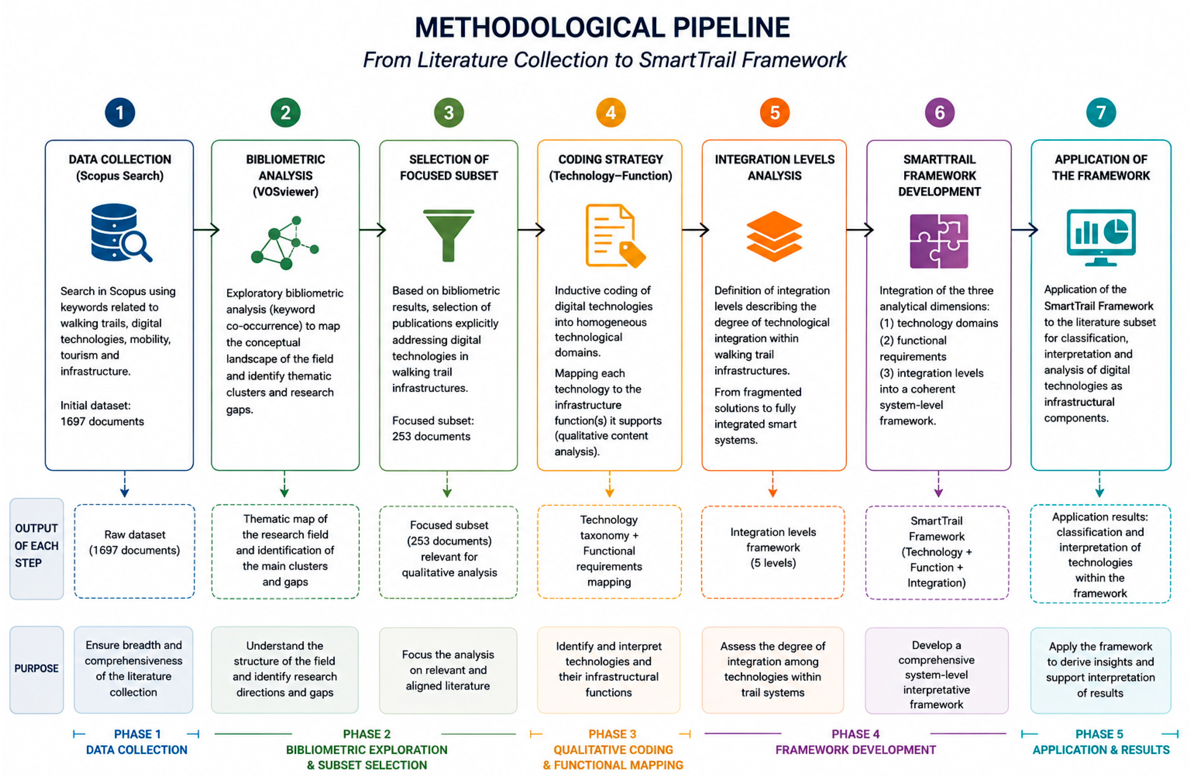
The methodological design integrates three complementary analytical dimensions: (i) systematic data collection and corpus construction, (ii) bibliometric exploration of the research field, and (iii) inductive coding and framework development based on technology classification, functional interpretation and system integration [
7,
8]. These dimensions are operationalised through a sequential but interrelated procedure as illustrated in the methodological pipeline (
Figure 1).
Figure 1, Figure 5 and Figure 6 were created with the assistance of Generative AI tools (GPT-5.6) to improve their graphical representation.
2.1. Research Design
The research design is based on a multi-step structured literature review aimed at ensuring both breadth of coverage and analytical depth [
4]. The overall logic is abductive, combining exploratory bibliometric analysis with deductive classification and coding procedures.
The unit of analysis consists of peer-reviewed scientific contributions addressing walking trails, walking tourism and digital technologies in mobility and infrastructure contexts [
9]. The analytical focus is placed on technologies as infrastructural components rather than as isolated tools, with a focus on their functional role within walking trail systems [
10,
11].
2.2. Data Collection and Corpus Construction
Data were collected using the Scopus database, adopted due to its multidisciplinary coverage of transport, tourism, engineering and information systems literature [
12,
13]. The initial search strategy combined three groups of keywords related to walking trails, digital technologies and application domains in mobility and infrastructure systems.
The search string was defined as: TITLE-ABS-KEY ((“walking trail*” OR “hiking trail*” OR “long-distance trail*” OR “pilgrimage route*” OR “pedestrian route*” OR “walking tourism” OR “outdoor recreation”) AND (technology OR digital* OR smart OR IoT OR sensor* OR wearable* OR “artificial intelligence” OR GIS OR app*) AND (mobility OR transport OR tourism OR “outdoor recreation” OR infrastructure OR pedestrian)). The query was restricted to English-language publications and included journal articles, review papers, conference proceedings, book chapters, books and editorials. Subject areas not aligned with transport, tourism, engineering or digital systems were excluded [
4,
5].
To ensure absolute reproducibility and eliminate subjective human bias in the selection process, the reduction from the initial 1697 records to the final 253 was conducted entirely through an automated, syntax-based refinement within the Scopus database, rather than through manual screening. A subsequent, highly restrictive search string was applied to act as a strict inclusion criterion, isolating studies explicitly addressing digital technologies in walking trail infrastructures. The second query was defined as: (“walking trail*” OR “hiking trail*” OR “long-distance trail*” OR “pilgrimage route*” OR “pedestrian route*” OR “walking tourism” OR “outdoor recreation”) AND (technology OR digital*) AND (mobility OR transport OR tourism OR “outdoor recreation” OR infrastructure OR pedestrian).
By limiting the technological keywords, this query systematically filtered out marginally related studies. Consequently, the selection of the 253 documents is fully transparent and directly replicable by applying the exact search string in Scopus. The complete Scopus dataset obtained from the first query (1697 documents) was used for the exploratory bibliometric analysis to map the broader research field. The focused subset obtained from the second query (253 documents) constitutes the analytical basis for the qualitative content analysis and framework development.
2.3. Bibliometric Analysis
An exploratory bibliometric analysis has been conducted to structure the thematic landscape of the field and support the definition of the analytical boundaries [
14]. Keyword co-occurrence analysis was performed using the software tool VOSviewer 1.6.20 [
14,
15], with a minimum occurrence threshold set to one in order to preserve the granularity of emerging thematic structures [
13,
16].
The bibliometric results highlight the multidisciplinary nature of research on walking trails and digital technologies, while also evidencing a limited number of studies addressing these systems from an integrated infrastructure perspective [
9,
12]. The bibliometric exploration provided an overview of the conceptual structure of the field and informed the selection of the literature subset subsequently subjected to qualitative coding and framework development.
2.4. Coding Strategy: Technology, Function and Integration
The coding strategy was applied exclusively to the focused subset of 253 publications. The definition of the six technological domains, five functional requirements, and four integration levels was not arbitrarily predetermined. Rather, it emerged inductively through a process of thematic saturation during the qualitative content analysis. Technologies and functions were iteratively grouped until no new distinct categories emerged, adapting established smart mobility classifications to the specific characteristics of the walking trail literature. The coding process is explicitly technology-centric and infrastructure-oriented, rather than user-oriented [
10].
Firstly, the digital technologies identified in the literature were inductively coded into homogeneous technological domains according to their infrastructural characteristics and functional role within walking trail systems. After, each technology was associated with the infrastructure function(s) it supports through qualitative content analysis [
10,
11,
17]. The resulting technology taxonomy and the identification of the corresponding functional requirements are presented in
Section 4. The functional mapping enables the interpretation of digital technologies as infrastructural components contributing to system-level performance rather than isolated technical solutions.
2.5. Framework Development and Integration Analysis
The final analytical dimension concerns the degree of integration among digital technologies within walking trail infrastructures. The concept of system integration is drawn from established approaches in transport systems engineering and smart infrastructure design [
18,
19]. The definition of the ILs emerged from the qualitative interpretation of the reviewed literature and constitutes the final step of the framework development process [
20,
21]. Their conceptual structure and operational characteristics are presented in
Section 5.
The integration framework is then combined with the technology classification and functional mapping dimensions to construct the proposed STF. This integrated analytical structure enables a comprehensive interpretation of digital technologies as infrastructural components of walking trail systems, capturing both their functional role and their degree of systemic integration [
22,
23].
The resulting framework supports a shift from a fragmented, tool-based interpretation of digital technologies towards a unified system-level understanding of digital infrastructure in walking trail environments.
3. Literature-Based Characterization of Digital Trail Systems
3.1. Scientific Production and Dataset Characterization (Scopus Analysis)
The Scopus search yielded 1697 publications covering the period 2010–2026. This dataset constitutes the bibliographic corpus analysed in this study and includes journal articles, conference papers, book chapters and reviews from multiple disciplinary domains, reflecting the multidisciplinary nature of research on digital technologies applied to walking trails [
10,
13,
20].
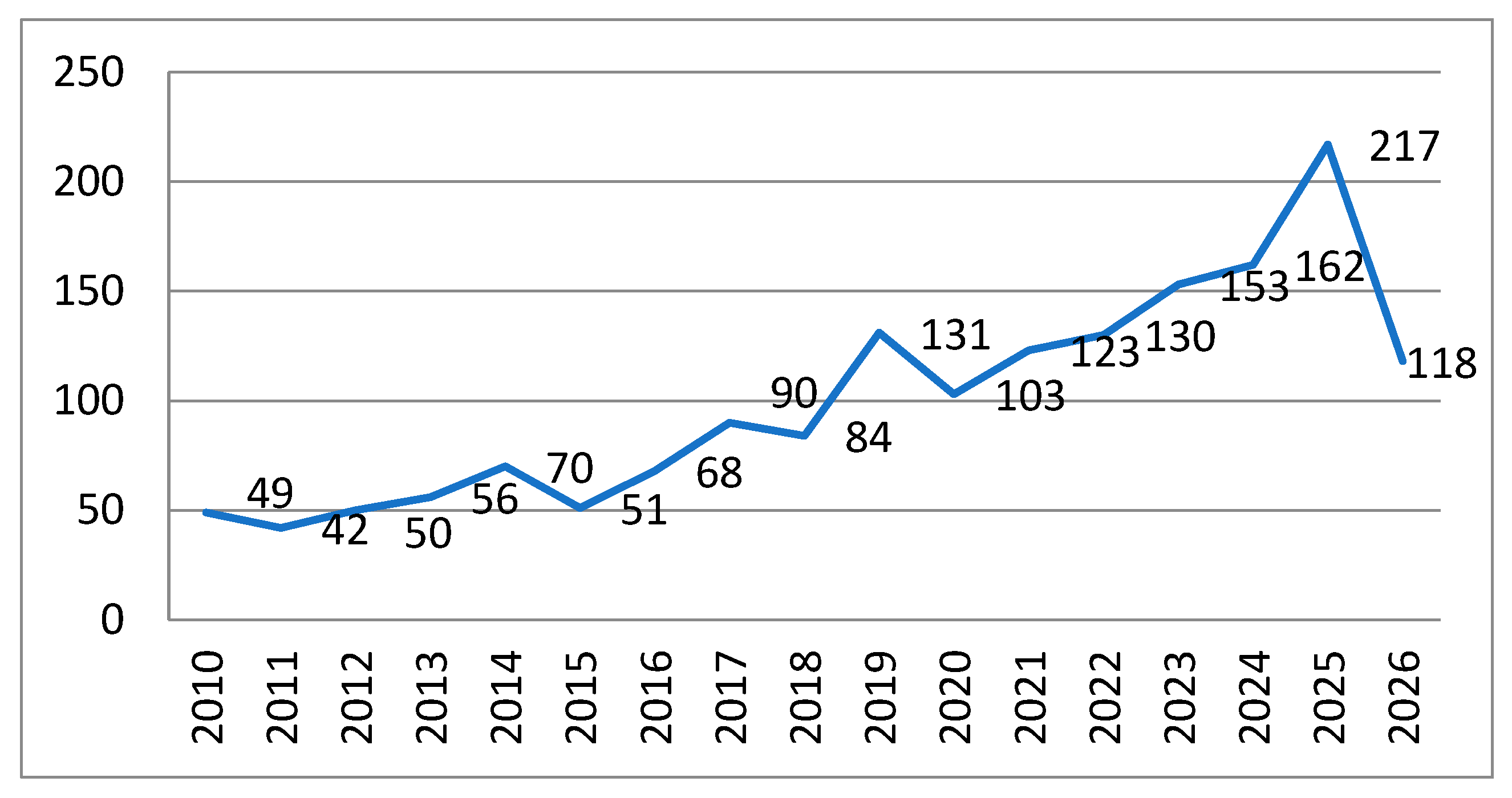
The temporal distribution of publications shows a clear non-linear growth pattern, with a relatively slow development phase between 2010 and 2016, followed by a progressive acceleration from 2017 onwards and a marked expansion after 2019. The peak is observed in 2025 (217 publications).
This trend, illustrated in
Figure 2, confirms the increasing scientific attention towards digital technologies applied to walking trail infrastructures, particularly in the post-2019 period [
7,
24,
25].
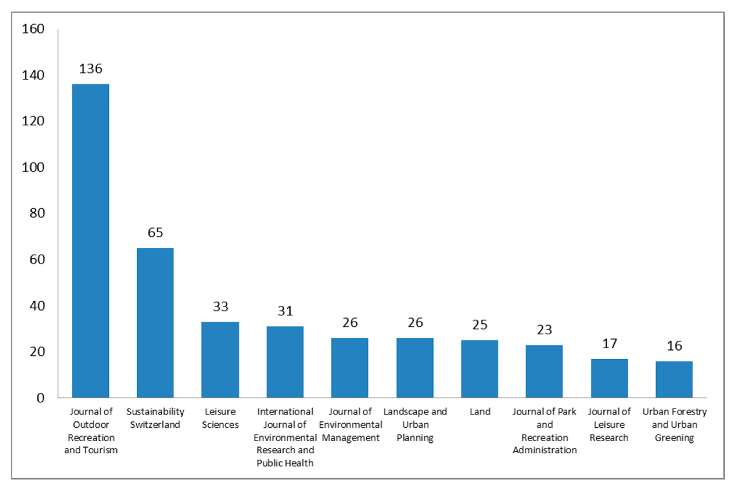
The scientific output is highly concentrated in a limited number of specialized journals in outdoor recreation, tourism, environmental management and geospatial sciences. The dominance of a small set of outlets indicates a partially consolidated but still evolving publication structure.
As shown in
Figure 3, the
Journal of Outdoor Recreation and Tourism is the leading outlet, followed by
Sustainability and other interdisciplinary journals bridging environmental sciences and tourism studies. This concentration pattern is consistent with analogous bibliometric analyses in adjacent research fields [
12,
16], indicating a partially consolidated but still evolving publication structure.
The geographical distribution highlights a strong dominance of the United States, followed by the United Kingdom, China, Canada and several European countries, including Italy, Spain, Germany, Sweden and Norway. This indicates a pronounced geographical asymmetry in research production [
7,
26].
Research activity is predominantly concentrated in Western Europe (46.1%) and North America (38.4%), while Asia shows an emerging but still secondary contribution [
13].
Overall, the Scopus-based descriptive analysis reveals a rapidly expanding and highly interdisciplinary research field characterized by three main structural patterns: (i) accelerated growth in scientific output after 2019 (
Figure 1), (ii) concentration of publications in a limited number of specialized journals (
Figure 2), and (iii) strong geographical asymmetry dominated by North American and European institutions (
Figure 3). The analysis highlights a heterogeneous research field; although scientific production has increased considerably over the last decade, the literature remains dispersed across disciplines and publication venues, suggesting the absence of a consolidated research framework [
4,
16]. This observation motivates the subsequent bibliometric network analysis.
3.2. Keyword Co-Occurrence Network Analysis
The bibliometric network analysis was conducted using VOSviewer software [
15] to explore the conceptual structure of research on walking trail infrastructures and associated digital technologies. The analysis is based on all keywords extracted from a Scopus dataset of 1697 documents covering the period 2010–2026. A co-occurrence analysis was performed using full counting, with a minimum occurrence threshold set to 1, resulting in a network composed of 77 items [
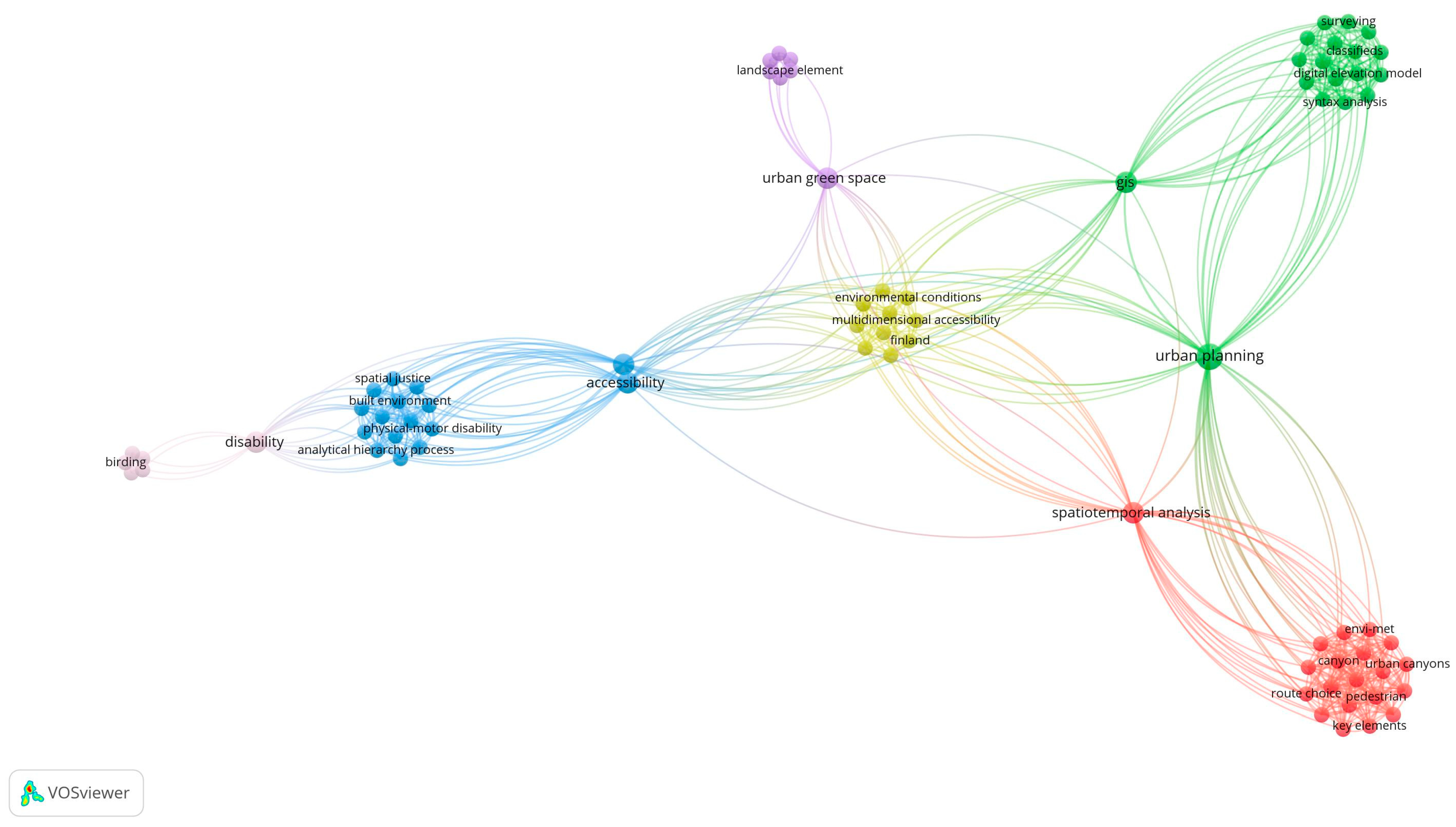
14] grouped into six clusters.
The objective has been the identification of the dominant thematic structures within the field and to assess the extent to which digital technologies are conceptually embedded in walking trail research. It is important to underline that the analysis is limited to keyword co-occurrence; no co-citation or bibliographic coupling analysis was performed, as the focus is on conceptual rather than intellectual or genealogical relationships between studies. The resulting network is presented in
Figure 4.
The network was generated in order to identify thematic proximity among concepts related to walking trails, mobility, environmental systems and digital technologies. It reveals a clearly segmented thematic structure composed of six clusters:
Cluster 1 (microclimate and pedestrian environmental dynamics), red, is characterized by terms related to thermal comfort, street canyon effects, terms related to ENVI-met modelling, route choice and spatio-temporal analysis, route choice and spatio-temporal analysis; this cluster reflects a strong environmental physics orientation focused on pedestrian exposure within built environments [
27,
28].
Cluster 2 (GIS and spatial network analysis), green, includes GIS, space syntax, urban networks, walkability and spatial planning tools; the cluster represents the dominant methodological backbone of spatial analysis in walking-related studies [
26,
27,
28].
Cluster 3 (accessibility and mobility equity), blue, is associated with accessibility, mobility, disability, travel behavior and fuzzy multi-criteria decision models. It reflects a socio-technical perspective on inclusive mobility systems [
10,
29,
30].
Cluster 4 (environmental quality and health outcomes), yellow, includes greenspace, noise pollution, mental health and outdoor recreation, highlighting the relationship between environmental conditions and human well-being [
28,
29,
30].
Cluster 5 (landscape perception and recreational environments), purple, is centered on landscape preference, urban parks, ecosystem recreation and social media-based landscape evaluation [
30,
31,
32].
Cluster 6 (inclusive and niche recreational practices), pink, includes birdwatching, disability inclusion and strengths-based approaches, representing specialized recreational and accessibility-driven applications [
30,
31,
32,
33].
The overall network structure reveals a highly fragmented conceptual landscape, where thematic clusters remain weakly interconnected. Three structural characteristics emerge:
There is a clear separation between GIS-based analytical studies (Cluster 2) and environmental and ecological studies (Clusters 1 and 4), indicating limited methodological integration between spatial modelling and environmental assessment approaches;
Accessibility and mobility equity research (Cluster 3) is largely disconnected from both technological and infrastructural perspectives, suggesting that inclusivity is treated as a socio-spatial issue rather than a system-level design constraint;
No autonomous technological cluster emerges from the network. Keywords associated with Internet of Things (IoT), Artificial Intelligence (AI), wearable devices and integrated smart infrastructures appear only marginally and remain dispersed across different thematic areas, suggesting that digital technologies are predominantly treated as supporting tools rather than as infrastructural systems [
33,
34].
The bibliometric analysis therefore reveals that, although smart infrastructure concepts thrive in broader transportation research, the specific literature on walking trails has not yet adapted these paradigms into a coherent conceptual framework for interpreting digital technologies. Rather than representing an established research domain, digital technologies remain embedded within environmental, spatial or behavioural studies [
35,
36]. To further investigate this gap, a subset of 253 papers explicitly addressing digital technologies in walking trail contexts was selected for detailed qualitative content analysis [
4,
5]. Rather than focusing on bibliometric relationships, the subsequent analysis examines the technologies described in the literature, their infrastructural functions and their level of system integration [
21,
25,
37]. The results of this analysis are presented in the following sections.
4. Technology Classification and Functional Requirements
The qualitative content analysis was conducted on a subset of 253 Scopus-indexed publications explicitly addressing digital technologies in walking trail contexts. Unlike the bibliometric analysis presented in the previous chapter, which explored the conceptual structure of the research field, this phase focuses on the technological solutions described, implemented or empirically evaluated in the literature.
The review reveals a broad spectrum of digital technologies supporting different aspects of walking trail management, visitor experience, environmental monitoring and information provision (
Table 1). However, the literature is characterised by considerable heterogeneity in terminology, application domains and technological maturity, making systematic comparison difficult. To provide a coherent overview of the state of the art, the identified technologies were grouped into six technological domains based on their primary characteristics. This organisation is intended to facilitate the subsequent development of the proposed classification framework rather than to represent a functional categorisation. To address potential overlaps (e.g., between AI systems and Cloud platforms), technologies were classified based on their primary infrastructural role: Cloud platforms act as the structural data-sharing backbone, whereas AI systems represent the analytical layer for predictive and automated processing.
It is important to note that this six-domain taxonomy is phenomenological and empirically driven, reflecting how technologies are currently clustered and discussed within the walking tourism literature, rather than adhering to a strict technical hierarchy (such as the standard three-layer IoT architecture). This approach was chosen to faithfully map the existing literature landscape, which frequently mixes end-user applications, physical sensing layers, and enabling capabilities.
4.1. General Trends Emerging from the Literature
The review of the selected publications reveals several common trends across the different technological domains.
First, the literature is strongly dominated by mobile applications and GIS-based solutions, which together account for the majority of reported technological implementations. Second, more advanced technologies, including IoT systems, AI applications and cloud-based digital platforms, are considerably less represented and are often described through pilot projects or experimental case studies rather than large-scale operational implementations. Third, many studies examine individual technologies independently, with limited attention devoted to interactions among different technological components. As a consequence, the current body of knowledge provides extensive information on specific digital solutions but offers relatively limited understanding of how these technologies may operate collectively within walking trail infrastructures. These findings provide the basis for a subsequent analysis, which abstracts from individual technologies to identify the functional requirements that digital infrastructures are expected to support.
4.2. Functional Requirements of Walking Trail Infrastructure
Walking trails are commonly described as physical routes connecting natural, cultural and recreational destinations. However, the increasing diffusion of digital technologies suggests that contemporary walking trails should also be interpreted as socio-technical infrastructures in which physical assets, digital systems, users and management processes continuously interact. To establish clear conceptual boundaries in this study, ‘digital trail infrastructure’ is broadly defined to encompass all digital components that mediate the interaction between users, managers, and the physical trail environment. Therefore, this infrastructural asset includes back-office management systems, field-deployed sensing devices, and end-user applications (such as mobile apps and wearables). Even when these user-oriented tools operate as standalone solutions without real-time data exchange (as classified in IL1 configurations), they are still considered fundamental infrastructural components because they fulfill core operational functions like navigation and information delivery.
From this perspective, individual technologies are not considered as isolated artefacts but as infrastructure components contributing to the delivery of specific system functions. Consequently, understanding the role of digital technologies requires shifting the analytical focus from the technologies themselves to the functional requirements that they support.
This abstraction represents the conceptual bridge between the descriptive review of digital technologies already presented and the infrastructure-oriented classification framework here proposed.
The functional requirements were derived through qualitative content analysis of the reviewed literature. Rather than assigning a single predefined function to each technology, the analysis examined the operational purposes for which digital technologies were employed across different studies. Similar purposes were progressively grouped into broader infrastructure functions through an iterative coding process.
This procedure allowed heterogeneous technological applications to be interpreted according to the infrastructure services they contribute to delivering, independently of the specific technology employed. The resulting functional model therefore represents an abstraction of recurring operational needs emerging from the literature rather than a classification of technologies. 5 functional models can be defined:
Navigation and orientation. Infrastructure capabilities supporting route identification, spatial guidance, positioning and movement along walking trails; these functions encompass digital mapping, route guidance, geolocation services and spatial information supporting walkers before and during their journey.
Safety and emergency management. It refers to infrastructure capabilities aimed at reducing operational risks and improving emergency response; typical activities include hazard notification, emergency communication, environmental monitoring and risk management, which are fundamental for the long-term conservation of the trail’s natural ecosystem.
Comfort and well-being. Infrastructure services that enhance the overall walking experience by supporting physical conditions, accessibility, environmental quality and user satisfaction; these functions extend beyond physical comfort to include environmental awareness and personalised support services.
Information and planning. Encompassing all activities related to information provision before and during the walking experience; these include route planning, destination information, points of interest, accommodation, weather conditions and other decision-support information available to walkers.
Operational logistics. It refers to infrastructure management activities supporting the operation and maintenance of walking trail systems, including infrastructure monitoring, maintenance planning, visitor flow management, asset management and coordination among different stakeholders responsible for trail operation, thereby ensuring that tourism development does not exceed the environmental carrying capacity of the territory. The proposed functional model does not establish a one-to-one correspondence between technologies and infrastructure functions. The review demonstrates that most digital technologies contribute simultaneously to multiple operational requirements, while each infrastructure function may be supported by different technological solutions. Then, technologies and functions should be considered as two diverse analytical dimensions. Technologies represent the means through which digital services are implemented, whereas functional requirements describe the infrastructure capabilities that they collectively enable.
To illustrate these functions in real-world contexts, consider the Appalachian Trail, where IoT networks and management frameworks are practically deployed for resource management and environmental monitoring [
11] or the Bavarian Forest National Park, where GNSS-based and GIS platforms are integrated to assess visitor spatial distribution and support operational logistics [
37].
5. Integration Levels and SmartTrail Framework
The review presented shows that digital technologies adopted in walking trail systems are highly heterogeneous in terms of technical characteristics, application domains and implementation contexts. Describing technologies individually provides valuable information on their capabilities but does not allow systematic comparison across studies or infrastructure contexts. To address this limitation, a technology classification system is proposed, useful for interpreting digital technologies according to the infrastructure functions they are able to support. Rather than replacing conventional technology-based classifications, the proposed framework introduces an additional interpretative dimension that links technological solutions to infrastructure requirements. This approach enables heterogeneous technologies to be analysed within a common conceptual framework while preserving their technological specificity.
5.1. Technology Classification
The six technological domains identified through the literature review were used as the technological dimension of the proposed framework. Each domain groups technologies sharing similar technological characteristics, independently of the infrastructure function they perform. Consequently, the classification preserves the technological identity of each solution while enabling subsequent functional mapping.
5.2. Technology–Function Mapping
The qualitative analysis demonstrates that no digital technology is associated with a single infrastructure function. Instead, the reviewed studies indicate that many technologies contribute simultaneously to multiple operational requirements. Conversely, each functional requirement may be supported by different technological domains. This many-to-many relationship is formalised through a Technology–Function (T–F) matrix, which represents the relational structure between technological domains and infrastructure functions as a bipartite analytical system. The resulting matrix illustrates the multidimensional nature of digital trail infrastructures:
Mobile applications primarily support Navigation and Information, while also contributing to Safety through functionalities such as route guidance, real-time information delivery and emergency communication;
GIS technologies mainly support Navigation, Information and Logistics by enabling spatial route planning, geographic visualisation and infrastructure management;
IoT systems contribute primarily to Safety and Logistics through environmental monitoring, infrastructure condition monitoring and real-time asset management;
AI supports Navigation, Safety, Information and Logistics by enabling applications such as route optimisation, predictive maintenance and environmental risk assessment;
Cloud platforms provide enabling capabilities across all five infrastructure functions by supporting data sharing, interoperability and service coordination.
The T–F matrix (
Table 2) highlights several structural characteristics. Digital technologies rarely support a single operational requirement, indicating a high degree of functional overlap across technological domains. Infrastructure functions are typically enabled through combinations of complementary technologies rather than isolated solutions. Some technologies—particularly cloud platforms, GIS systems, and AI—exhibit a highly transversal role within the matrix, supporting multiple infrastructure functions simultaneously.
These findings confirm that the technological dimension alone is insufficient to describe digital trail infrastructures and justify the introduction of an additional integration dimension, which is operationalised in the following section.
5.3. System Integration as an Infrastructure Property
Walking trail infrastructures increasingly incorporate multiple digital technologies operating simultaneously. However, the mere presence of several technologies does not necessarily imply that the infrastructure functions as an integrated digital system. Digital maturity therefore depends not only on the number or diversity of technologies adopted, but also on the degree to which these technologies exchange information, coordinate their operation and collectively support infrastructure management. From this perspective, system integration represents an independent analytical dimension that complements technology classification and functional analysis. While technology domains describe the technological components and functional requirements describe the services expected from the infrastructure, ILs characterise how these components interact within the overall system architecture. System integration is therefore an attribute of the walking trail infrastructure itself, rather than of individual technologies or descriptive studies.
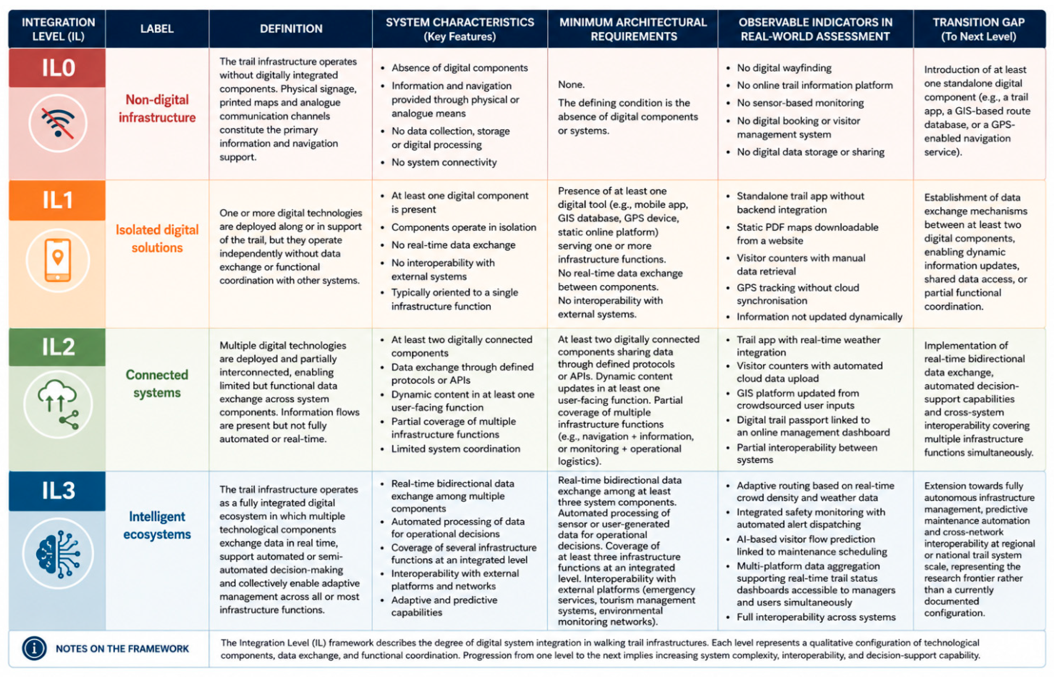
The ILs framework characterises the degree of systemic integration of digital technologies within walking trail infrastructures. Unlike technology classifications, which describe the nature of individual digital solutions, the ILs framework evaluates how these technologies interact to form increasingly integrated infrastructure systems. The proposed model adopts an infrastructure-oriented perspective in which the unit of analysis is the walking trail system rather than individual technologies or publications (
Figure 5).
Four progressive ILs are identified, ranging from non-digital infrastructures (IL0) to fully integrated intelligent ecosystems (IL3). Progression across the levels reflects increasing interoperability, data exchange, functional coordination, automation and decision-support capability. Each level is defined through a set of complementary criteria including its conceptual definition, the minimum architectural requirements necessary for classification, observable indicators that support field-based assessment and the transition conditions required to achieve the subsequent level.
The framework is designed to support both literature-based classification and the direct assessment of real-world trail infrastructures. In the context of this study, it provides the third analytical dimension of the STF by complementing the technology taxonomy and functional requirement model.
While these Integration Levels (IL0–IL3) draw upon established digital maturity models in smart city literature, in the context of this study they serve as a qualitative heuristic tool for conceptual classification rather than a strictly quantitative measurement.
5.4. System-Level Framework
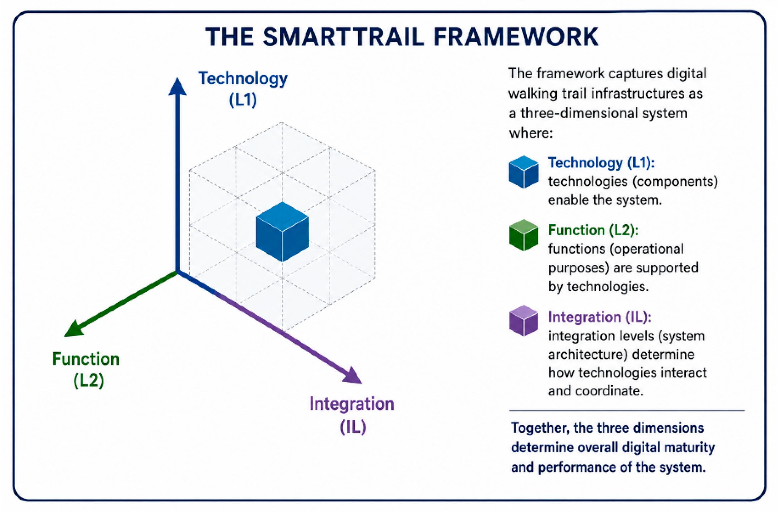
The proposed framework combines the three analytical dimensions developed throughout this study: technology domains, functional requirements, and ILs. Together, these dimensions provide a multidimensional representation of digital walking trail infrastructures (
Figure 6).
Technologies define the system components, functional requirements describe the operational purposes they serve, and ILs capture the relational architecture among components. The resulting analytical model represents a system-level abstraction of walking trail infrastructures, in which structural properties emerge from the interaction between technological and functional dimensions.
In this study, the framework is operationalised through a qualitative content analysis of the reviewed literature. Each publication is treated as an empirical trace of an underlying infrastructure configuration, enabling indirect classification of system ILs.
Importantly, the framework is not methodologically dependent on literature-based data. It is designed as a transferable analytical instrument that can be applied both to secondary sources (e.g., academic and technical literature) and to primary empirical data describing real-world infrastructures.
5.5. Structural Characteristics Emerging from the Framework
Application of the framework reveals several recurring structural patterns in walking trail digitalisation. These patterns refer to infrastructure configurations reconstructed from the literature, rather than to the publications themselves.
First, most systems fall within IL1 and IL2, indicating that digitalisation is predominantly characterised by isolated or partially connected technologies rather than fully integrated ecosystems. Second, navigation and information services dominate the technological landscape, while logistics, monitoring and infrastructure management functions remain underdeveloped. Third, highly flexible technologies such as GIS, cloud computing and AI are frequently present but rarely embedded within fully interoperable architectures. Finally, IL3 configurations appear only marginally, suggesting that fully intelligent walking trail ecosystems remain emergent rather than established.
5.6. Framework Implications
The proposed framework demonstrates that digital transformation of walking trail infrastructures should not be assessed solely through the adoption of individual technologies. Rather, technological development should be interpreted as the progressive evolution of integrated infrastructure systems capable of supporting multiple operational functions through coordinated digital components. The three-dimensional framework proposed provides a common analytical language for comparing heterogeneous technological solutions and identifying different levels of infrastructure maturity across walking trail systems. This framework also establishes the conceptual basis for future quantitative assessment methods capable of evaluating digital maturity and supporting infrastructure planning.
Although initially operationalised through a literature-based review, the framework is conceived as infrastructure-general and can be directly applied to real-world walking trail systems, enabling both ex-post analysis (literature) and ex-ante/on-field assessment (empirical infrastructures).
6. Main Results
The application of the STF to the literature corpus reveals three overarching findings. First, the current technological landscape is strongly dominated by user-oriented and information-centred solutions, whereas technologies supporting infrastructure management remain comparatively underrepresented. Second, digital technologies exhibit considerable functional heterogeneity, with navigation and information services prevailing over safety and operational management functions. Third, despite the increasing diffusion of digital solutions, most walking trail systems remain characterised by low to intermediate levels of system integration, indicating that technological adoption has progressed more rapidly than infrastructure integration. The following sections examine these findings across the three analytical dimensions of the framework.
6.1. Distribution of the Classified Corpus
The qualitative content analysis of the 253 selected publications reveals a heterogeneous but structurally interpretable landscape of digital technologies applied to walking trail infrastructures. Of the total corpus, 78 studies (30.8%) were classified as IL0 because they addressed sociological, behavioural, governance or planning aspects without describing digital technologies directly embedded within trail infrastructures. The remaining 175 publications (69.2%) constitute the digitally relevant corpus and provide the empirical basis for the technology classification, functional mapping and integration-level assessment developed in this study. The temporal distribution of this subset indicates that research on digital trail infrastructures is a rapidly emerging field rather than a consolidated research domain. Nearly half of all publications (48.6%) were published between 2023 and 2026, while the median publication year is 2022, confirming the recent acceleration of scientific interest in digital trail systems.
6.2. Distribution Across Technology Domains
The technology classification highlights a clear concentration of the literature around user-oriented digital platforms and spatial information systems, whereas sensing technologies and intelligent infrastructures remain comparatively less represented. Digital platforms and cloud ecosystems constitute the largest technological domain (26.9%), followed by mobile applications (22.3%) and GIS-based systems (17.7%). Artificial intelligence accounts for 13.1% of the classified studies, while IoT sensing systems and wearable technologies represent 12.6% and 7.4%, respectively.
Overall, these findings indicate that current research remains largely focused on technologies supporting user interaction, navigation and information provision. Instead, embedded sensing systems, adaptive infrastructures and intelligent management platforms remain a relatively limited proportion of the literature, suggesting that the digital transformation of walking trail infrastructures is still predominantly user-oriented rather than infrastructure-oriented.
6.3. Distribution Across Functional Requirements
The functional analysis reveals an uneven distribution of infrastructure capabilities. Information and planning represent the most frequently supported function (49.1%), closely followed by navigation and orientation (44.6%) and operational logistics (41.7%). Comfort and well-being (24.0%) and safety and emergency management (21.1%) appear considerably less developed. Note that percentages reflect the frequency of occurrence within the dataset. Since a single technology can support multiple functions simultaneously, these functional categories are not mutually exclusive.
Individual studies frequently contribute to multiple functional requirements, confirming that digital technologies rarely perform a single operational role. The predominance of information and navigation reflects the widespread adoption of mobile applications and digital platforms, whereas the limited representation of safety and operational management highlights the comparatively slow development of technologies supporting infrastructure operation and resilience.
The analysis also reveals distinctive functional profiles across technological domains. Mobile applications primarily support navigation and information services, GIS technologies exhibit a transversal role spanning navigation, planning and operational management, IoT systems are mainly associated with monitoring and logistics, wearable devices concentrate on navigation and user well-being, while AI demonstrates the broadest functional coverage, contributing simultaneously to navigation, safety and operational logistics. Digital platforms predominantly facilitate information dissemination and operational coordination.
6.4. Predominance of Navigation-Oriented Technologies
Navigation and orientation emerge as the structural backbone of contemporary digital trail infrastructures. This function is supported by all six technological domains and represents the principal area of convergence between user-oriented applications and infrastructure services. However, the predominance of navigation conceals an important structural limitation. Most navigation solutions operate as independent digital services rather than as components of integrated infrastructure ecosystems. Advanced capabilities such as adaptive routing, crowd-aware navigation and accessibility-sensitive guidance, which require real-time interoperability and coordinated data exchange, remain restricted to a limited number of highly integrated AI-based systems. This finding suggests that technological maturity is constrained less by the availability of navigation technologies than by the limited integration among digital components.
6.5. Uneven Development of Safety and Information Functions
The analysis reveals a marked imbalance between the operational importance of safety management and its current technological implementation. Safety and emergency management is the least represented functional requirement, despite being fundamental for resilient trail infrastructures. Existing implementations are concentrated almost exclusively within IoT and AI applications and remain largely confined to experimental or pilot-scale deployments.
Although the literature documents innovative examples, including Social IoT routing systems, drone-assisted hazard monitoring and real-time environmental sensing, these solutions rarely evolve into integrated operational infrastructures. Then, safety management remains an ancillary rather than a core function of most digital trail systems.
Information services display a considerably higher level of maturity but also substantial internal heterogeneity. Implementations range from static repositories of trail information to dynamic platforms integrating real-time environmental conditions and crowdsourced updates. This progression closely mirrors the transition from IL1 to IL2–IL3 configurations, illustrating how increasing levels of integration transform information provision from static content delivery into adaptive infrastructure services.
6.6. Operational Logistics as the Principal Infrastructural Gap
Although operational logistics appears in more than 40% of the classified studies, its functional profile remains comparatively shallow. Many contributions focus on visitor counting, movement monitoring or behavioural analysis as isolated research activities rather than as components of integrated management architectures.
Comprehensive logistics systems supporting maintenance scheduling, asset management, infrastructure monitoring and multi-stakeholder coordination are only sporadically documented. This imbalance confirms that current technological development is largely driven by demand-side objectives centred on visitor experience, while the operational needs of infrastructure managers receive substantially less attention. Operational logistics therefore represents the most significant gap separating current digital trail systems from genuinely intelligent infrastructure ecosystems.
6.7. Distribution of ILs
The integration-level analysis confirms that contemporary walking trail digitalisation is characterised primarily by intermediate levels of technological integration. Connected systems (IL2) represent nearly half of the classified corpus (48.6%), while isolated digital solutions (IL1) account for approximately one third (31.4%). Fully integrated intelligent ecosystems (IL3) remain limited to 20% of the analysed studies.
The cross-analysis between technological domains and ILs reveals important structural differences. GIS implementations remain predominantly static or only partially connected, whereas mobile applications rarely progress beyond isolated deployments. Conversely, AI consistently achieves the highest ILs, while IoT technologies occupy an intermediate position between standalone sensing applications and integrated intelligent infrastructures.
These findings indicate that technological sophistication alone does not guarantee infrastructure maturity. Rather, the defining characteristic of advanced digital trail systems lies in the ability to integrate heterogeneous technologies into coordinated infrastructures capable of supporting multiple operational functions simultaneously.
6.8. Evidence of a Fragmented Digital Ecosystem
Taken together, the three analytical dimensions converge on a coherent interpretation of the current state of digital trail infrastructures. Although technological diversity is considerable, the overall digital ecosystem is characterised by limited systemic integration. This structural fragmentation manifests itself along three complementary dimensions. The first is technological, as the six identified technology domains generally evolve independently and exhibit limited interoperability. The second is functional, since no study documents an infrastructure capable of simultaneously supporting all five functional requirements at an advanced IL. The third is operational, with highly integrated implementations largely confined to pilot projects and experimental demonstrators rather than mature operational trail systems. Overall, the findings indicate that the principal challenge facing walking trail digitalisation is no longer the adoption of additional technologies but their effective integration into coherent socio-technical infrastructures. The transition from isolated digital tools to interoperable infrastructure ecosystems therefore represents the key pathway towards the development of intelligent, resilient and adaptive walking trail systems.
7. Discussion
The results provide evidence that digitalisation in walking trail systems cannot be adequately understood through technology-centred classifications alone. This section discusses how the proposed STF framework advances current knowledge by introducing infrastructural integration as a complementary analytical dimension. The implications for infrastructure theory, planning practice, and future research are subsequently examined.
7.1. Overcoming the Tool-Based Logic
The results confirm and extend the core motivation of this study. The literature on digital technologies in walking trail systems is predominantly organised around discrete tools rather than systemic infrastructure relationships. The proposed framework challenges this logic by reinterpreting technologies as infrastructural components embedded within an architectural system defined by ILs. This shift has both conceptual and methodological implications. Conceptually, it relocates the unit of analysis from individual technologies to infrastructure configurations, understood as relational structures among technologies, the functions they enable, and their degree of systemic coherence. Methodologically, it introduces a multidimensional classification that positions heterogeneous digital solutions within a common analytical space, independent of their technical specificity. This transition is not a taxonomic refinement but a reconceptualisation of digitalisation in walking trail infrastructure: not the accumulation of digital artefacts, but the progressive construction of an integrated architecture enabling coordinated and adaptive management.
7.2. Walking Trails as Socio-Technical Infrastructure Systems
The proposed model conceptualises walking trails as socio-technical infrastructure systems in which physical assets, digital components, environmental conditions, human practices, and management processes are continuously interdependent. This extends established approaches in transport infrastructure and systems engineering to slow mobility and recreational networks. Under this perspective, digital technologies cannot be assessed by individual specifications, but by the infrastructure services they collectively enable and their embedding within coordinated operational architectures. Accordingly, an isolated AI-based simulation tool contributes less to infrastructure maturity than a simpler but fully interoperable system of sensors, routing services, and real-time platforms.
Existing classifications fail to capture this relational dimension, as they describe technological capabilities without accounting for systemic positioning. The proposed framework addresses this limitation by introducing ILs as an additional analytical dimension alongside technology domains and functional requirements.
7.3. The Centrality of the Concept of Integration
Integration level (IL) is the core analytical contribution of the framework. Results show that IL does not correspond to technological density: IL3 systems are not necessarily more technologically complex, but are characterised by real-time data exchange, interoperability, and automated decision-support enabling adaptive responses. This distinction has direct implications for assessment practices. Evaluations based on technology inventories risk overestimating system maturity: a combination of navigation apps, sensors, and monitoring stations may still correspond to IL1 if components are not integrated. Conversely, IL assessment requires attention to architectural properties such as data protocols, interoperability, and sensor-to-decision connectivity, often absent from planning documentation.
The prevalence of IL1–IL2 configurations reflects both the current state of trail infrastructures and the lack of integration-oriented design frameworks in planning and governance. At IL3, such integration is often supported by resilient communication layers, including distributed network architectures such as mesh systems, which enable continuous data exchange across spatially fragmented trail segments.
7.4. Implications of Technological Fragmentation
The observed fragmentation reflects not only the literature but also the structure of real-world trail systems. Digital technologies are typically deployed as isolated solutions, fulfilling specific functions without systemic coordination.
Such configurations limit infrastructure performance. IL1–IL2 systems cannot support coordinated management functions such as real-time safety monitoring, integrated visitor flow management, or adaptive routing. These limitations are particularly critical in high-density or high-risk contexts requiring multi-system coordination.
Fragmentation also has equity implications. Accessibility-oriented services for people with reduced mobility or specific needs depend on personalised, real-time, and multi-system integration, typical of IL3 configurations. Their limited presence indicates a lack of systemic inclusiveness in current digital trail infrastructures.
7.5. The Importance of Interoperability in Slow Mobility Systems
Interoperability is the key enabling condition for IL transition. Defined as the capacity of heterogeneous systems to exchange and operationalise data in real time, it underpins the shift from IL2 to IL3 configurations. In environments characterised by limited or intermittent connectivity, mesh networking architectures can further support decentralized data propagation, enabling localised interoperability even in the absence of stable centralised communication infrastructures.
In slow mobility contexts, interoperability is constrained by governance and technical heterogeneity. Trail systems are managed by multiple actors with independently developed digital infrastructures, limited coordination, and low standardisation. In addition, geographic dispersion and variable connectivity further constrain real-time integration. User heterogeneity reinforces the need for adaptive systems requiring high ILs. Addressing these constraints requires both technological and governance solutions, including shared data standards and coordinated platform architectures. The proposed framework provides a conceptual basis for aligning infrastructure design with these requirements.
In the European context, although recent legislation recognises walking trails as infrastructure assets, it does not define digital interoperability requirements. The proposed STF may support the development of such standards within international funding frameworks, including Next Generation EU and Cohesion Policy programmes in Europe.
7.6. Theoretical Implications
Within the broader body of research on walking trails, this study contributes by shifting the analytical focus from tourism-oriented and technology-specific perspectives towards an infrastructure-system interpretation of trail digitalisation.
The study contributes to three areas of literature. First, it extends infrastructure theory to slow mobility systems, demonstrating that smart infrastructure logic is applicable beyond high-density transport contexts, provided that domain-specific adaptations are introduced. Moreover, it operationalises infrastructural integration through a domain-specific classification system based on empirically derived ILs; this complements existing maturity models by focusing on relational and functional properties rather than technological readiness. Finally, it identifies a set of five functional requirements—navigation, safety, comfort, information, and operational logistics—and demonstrates their multi-mappability across heterogeneous technologies, advancing a systemic understanding of digital trail infrastructure.
7.7. IL Framework Positioning
The IL framework is a classificatory scheme, not a performance index. It identifies qualitatively distinct configurations of infrastructural integration rather than producing scalar evaluations or rankings. This distinction avoids distortions typical of composite indices, such as artificial comparability and loss of structural heterogeneity. Instead, ILs capture the presence or absence of relational properties—data exchange, interoperability, automation, and real-time responsiveness—that define system architecture. The framework is intended to support description, comparison, and gap analysis. Its value lies in making visible the structural differences between fragmented and integrated digital trail systems, rather than in producing quantitative rankings.
7.8. Synthesis of Research Questions Responses
This study provides a structured response to the research questions guiding the analysis. Regarding RQ1, digital technologies in walking trail systems can be systematically classified through a multidimensional taxonomy organised around six technology domains, which capture functional and structural heterogeneity beyond tool-level descriptions. With respect to RQ2, these technologies support five core functional infrastructure requirements (navigation, safety, comfort, information, and operational logistics), although their distribution is uneven, with safety and logistics remaining comparatively underdeveloped. In relation to RQ3, the analysis reveals that most documented implementations are concentrated at IL1 and IL2, indicating that digital trail systems are characterised by technological diversity but limited systemic integration, with IL3 configurations remaining relatively rare and mainly associated with AI- and IoT-enabled architectures. Finally, addressing RQ4, the results demonstrate that the proposed framework can support infrastructure managers and planners by providing a shared analytical language to identify integration gaps, prioritise measures, and shift development strategies from technology accumulation towards system-level integration.
A potential difficulty in applying this framework globally is the disparity in baseline infrastructure: remote trails in developing regions often face intermittent internet connectivity and fragmented local governance, which can severely constrain the transition to higher Integration Levels.
8. Conclusions
This paper has developed a system-level framework for the classification and functional interpretation of digital technologies in walking trail infrastructures. The framework addresses a clear gap in the literature by translating established concepts from smart mobility and digital infrastructure into the context of slow tourism, providing a unified analytical instrument capable of conceptualising trail technologies as interconnected infrastructure components.
The principal contribution is a three-dimensional analytical structure integrating technology domains, functional requirements and ILs. Applied to a corpus of 253 Scopus-indexed publications, the framework shows that 175 documents (69.2%) address digitally relevant technologies, distributed across six technological domains and five functional requirements. ILs are predominantly concentrated at IL1 and IL2, indicating high technological diversity but low systemic integration. Only 20.0% of the corpus reflects IL3 configurations, largely associated with AI- and IoT-enabled implementations.
These findings have direct implications for planners, managers and policymakers. The current technological landscape, dominated by standalone applications, GIS platforms and partially connected services, is structurally insufficient to support coordinated, real-time, multi-functional infrastructure management. Strategies focused on the accumulation of individual technologies risk reproducing fragmentation rather than producing systemic capability. For local communities and trail managers, applying this model could offer concrete practical benefits, such as optimizing maintenance budgets, improving visitor safety allocation, and providing a structured justification to secure targeted funding for digital integration.
The framework suggests that the priority for trail infrastructure development is not technological expansion but architectural integration of existing and emerging components through shared data standards, interoperable platforms and governance arrangements that align digital responsibilities across actors. The transition from IL1–IL2 fragmentation to IL3 coherence requires deliberate design choices oriented towards integration rather than incremental technological accumulation. Emerging communication paradigms such as mesh networking may play a key role in enabling IL3 configurations in low-connectivity environments.
The synthesis of responses to the research questions confirms these findings. Digital technologies can be systematically classified through a multidimensional taxonomy (RQ1); they support five core infrastructure functions with uneven coverage across domains (RQ2); and they are predominantly deployed at low to intermediate integration levels (RQ3). From a managerial perspective (RQ4), the framework enables planners and policymakers to identify integration gaps and to reorient digital development strategies towards system-level coherence rather than incremental technological expansion.
A primary limitation of this study is its conceptual and exploratory nature. While the framework is designed to be transferable, the Integration Levels currently rely on qualitative thresholds derived from literature rather than empirical validation. Consequently, the framework represents an initial theoretical proposal that requires future on-field testing to transition into a fully operational planning instrument.
An additional methodological limitation is the reliance on a single academic database (Scopus). While Scopus provides extensive multidisciplinary coverage, excluding other key databases such as the Web of Science (WoS) Core Collection may introduce sampling bias.
For policymakers, the STF provides a basis for assessing digital maturity and identifying integration gaps that affect performance and accessibility. For planners and designers, it offers a common language for specifying integration requirements and comparing heterogeneous technological solutions within a system-level perspective. For trail managers, it supports the identification of priority intervention areas, particularly in safety and operational logistics, which emerge as the least developed functional domains.
Future research should proceed in four directions. First, empirical validation of the STF through field application to real-world trail systems, combining infrastructure audits, stakeholder interviews, digital platform analysis and, where available, sensor data. Pilot studies on Italian national trails (Law 13 February 2026, n. 24) or major European networks (EuroVelo, Via Francigena, Camino de Santiago) would ensure both methodological validation and policy relevance.
Second, quantitative operationalisation of the STF through the development of a SmartTrail Index (STI). While the STF is intentionally classificatory, its structure provides a foundation for a weighted scoring system enabling comparative assessment of digital maturity. The STI is conceived as a complementary extension of the STF, supporting benchmarking, funding allocation and longitudinal monitoring, while preserving the STF’s role as an interpretative framework.
Third, further research should address governance structures for digital trail ecosystems. Given the multi-actor nature of trail management, public authorities, voluntary organisations, tourism bodies and protected area managers, interoperability must be understood as both a technical and organisational challenge. Work on data governance models and coordination frameworks is essential for enabling IL3 implementation.
Fourth, the framework should be tested across adjacent slow mobility domains, including cycling networks, heritage routes, urban greenways and active travel corridors. This would allow assessment of its transferability and contribute to a broader theoretical foundation for digital infrastructure analysis in non-motorised mobility systems.
The central contribution of this paper is to shift the conceptualisation of digital technologies in walking trail systems from a set of isolated tools to an integrated infrastructure ecosystem capable of supporting coordinated, adaptive and equitable management. Achieving this shift requires not only technological development but also analytical instruments that render systemic properties visible, comparable and designable. The STF is proposed as such an instrument, grounded in a systematic literature review and intended as a foundation for both empirical research and policy development in slow mobility infrastructures.