Article

Spatiotemporal Performance Evaluation and Synergistic Optimization of Rural Living Environments (RLE): A Regional Clustering Perspective in the Metropolitan Fringe

1
Faculty of Economics and Management, Xi’an Fanyi University, Xi’an 710105, China
2
School of Architecture, Xi’an University of Architecture and Technology, Xi’an 710055, China
3
Shangluo Branch Company, Shaanxi Agricultural Development Group Co., Ltd., Xi’an 710075, China
*
Author to whom correspondence should be addressed.
Sustainability 2026, 18(11), 5403; https://doi.org/10.3390/su18115403
Submission received: 31 March 2026 / Revised: 14 May 2026 / Accepted: 18 May 2026 / Published: 27 May 2026
(This article belongs to the Section Health, Well-Being and Sustainability)

Abstract

Driven by the national Rural Vitalization Strategy, regional clustered development has become an essential approach to alleviate fragmented rural construction and shift isolated village governance toward integrated regional coordination. Against the research gap that most existing rural living environment (RLE) evaluations focus merely on individual villages while neglecting synergistic interaction within village clusters, this study aims to construct a targeted RLE performance evaluation framework from the perspective of cluster synergy, and further reveal spatial differentiation characteristics and developmental bottlenecks of rural settlements in metropolitan fringe tableland areas. Taking the Tangcun area of Bailuyuan in Xi’an as a typical case, this study adopts semi-structured interviews and qualitative grounded theory to extract core evaluation dimensions and establish a multi-layered RLE performance index system. On this basis, the Analytic Hierarchy Process (AHP) is employed to determine indicator weights and conduct quantitative performance evaluation. The results indicate that RLE performance presents an obvious topographical gradient following the pattern of tableland clusters > slope clusters > gully clusters, and exhibits a typical characteristic of non-material dimension convergence versus material dimension differentiation. The core constraints of local clustered development lie in unbalanced cross-cluster resource allocation, weak functional coordination, and the absence of sound public service sharing mechanisms. Corresponding optimization paths targeting spatial planning, facility allocation, ecological and cultural coordination, and multi-stakeholder governance are finally proposed. This study provides theoretical references and practical implications for RLE improvement and coordinated revitalization of similar loess tableland and metropolitan fringe village clusters.

1. Introduction

Driven by the national Rural Vitalization Strategy, optimizing rural living environments (RLEs) constitutes a prerequisite for realizing comprehensive sustainable development in China [1,2]. Since 2014, the central government has implemented a series of strategic frameworks, including the “Guiding Opinions on Improving RLE” and subsequent Three-year and Five-year Action Plans, to strengthen top-level design. As the physical manifestation of rural habitats, the quality of village environmental construction directly dictates the efficacy of creating “beautiful countrysides” suitable for both industry and residency [3]. Although traditional, decentralized construction models have yielded localized gains, they remain insufficient to address the integrated ecological requirements and resource consolidation mandated by contemporary national spatial planning [4,5]. Consequently, the clustering paradigm—centered on multi-village collaboration—has emerged as a pivotal trajectory for mitigating developmental fragmentation through resource integration and functional complementarity.
Advancements in human settlement science have shifted the focus of rural environmental research from macro-theoretical discourse toward granular empirical analysis. Within the disciplines of architecture and urban planning, the village environment is defined as a complex system composed of physical elements, including spatial form, architectural style, and infrastructure. While domestic scholars have established a robust foundation for this field, fine-grained empirical investigations focusing on village clusters—particularly in metropolitan fringe areas susceptible to the concomitant effects of urban radiation and siphoning—remain strikingly scarce [4]. Existing evaluations often subsume environmental construction within broader settlement studies [6], frequently employing Gary Goertz’s conceptual analysis. However, these frameworks often fail to encapsulate the nuanced collaborative dynamics inherent in the clustering model, leaving current administrative-based planning struggling to advance rural revitalization from a systemic perspective.
Furthermore, conventional spatial planning methods centered on isolated administrative units often prove inadequate for facilitating holistic revitalization [7]. As rural reforms deepen, various regions are exploring cluster-based development [8,9] to maximize resource value [10,11]. However, these practices remain in an exploratory phase, particularly for villages situated in the loess tableland regions of Northwest China [12], where development is significantly constrained by complex geomorphological conditions [13,14]. As the foundational carrier of rural development, analyzing the performance of environmental construction under the clustering model is essential. Identifying performance deficiencies and proposing targeted optimization strategies are critical for the rational allocation of rural resources and the success of localized revitalization efforts.
Despite the maturity of current frameworks, a critical gap persists: the traditional single-village environmental evaluation model fails to account for the spatial connectivity and resource complementarity necessitated by the Rural Revitalization Strategy [15,16]. Under the current paradigm of cluster-based development, the connectivity and synergy among neighboring villages are continuously strengthening. The “single-village” perspective often overlooks the cross-boundary flow of resources and the shared nature of infrastructure. Existing studies have largely focused on individual village nodes, leading to a disconnection between micro-scale evaluation and regional-scale planning. There is a profound lack of research that explores environmental performance from a cluster development perspective. Therefore, this study addresses the scenario of cluster-based rural development, emphasizing spatial connectivity, resource complementarity, and development synergy.
As a strategic component of the Greater Xi’an metropolitan area, the Bailuyuan region serves as a critical node for regional rural revitalization through its dedicated rural environmental initiatives. Tangcun area, situated in the metropolitan periphery of the Baqiao District, possesses unique geomorphological features and a rich cultural heritage. However, its socio-economic development currently lags behind, resulting in more pronounced environmental challenges compared to adjacent areas. To bridge these scholarly lacunae, this study formulates a comprehensive theoretical framework for RLE assessment that systematically incorporates the logic of regional clustering. Focusing on the Tangcun area, this study pursues three primary objectives:
  • To explore the rural living environment level of village settlements from the innovative perspective of cluster synergy effect, breaking the limitations of the traditional single-village evaluation paradigm.
  • To identify core evaluation dimensions and construct a standardized RLE assessment model based on semi-structured interviews and qualitative grounded theory analysis, laying a solid methodological foundation for subsequent relevant research.
  • To quantitatively reveal the spatial differentiation and systematic bottlenecks of RLE development in typical village clusters, and propose synergistic optimization strategies to provide empirical references for rural revitalization in similar metropolitan fringe and loess tableland areas.

2. Literature Review

2.1. Connotation and Complexity of RLE

The Rural Human Settlement Environment, hereafter referred to as the RLE, is conceptualized as a comprehensive surface space formed by the intricate interaction and organic integration of rural residential structures, ancillary facilities, and the surrounding natural environment [1,2,17]. As a pivotal subsystem of the broader human settlement framework, RLE exhibits marked heterogeneities from urban environments in terms of geomorphological landscapes, cultural heritage, spatial configurations, and developmental paradigms. Traditionally, villages were perceived as rudimentary settlement forms with linear structures. However, accelerated socio-economic transformation has fundamentally altered rural settlement patterns, evolving the RLE into a complex adaptive system that synthesizes ecological, social, geographical, and cultural attributes [1,18].
The complexity of the RLE is manifested in the multi-dimensional superposition of its core attributes. From the ecological dimension, rural residents inhabit an expansive natural ecosystem which serves not only as a reservoir of essential resources but also as the primary material carrier for regional sustainability [4]. From the social and cultural dimension, residents act as active agents of human settlement, embedding traditional culture, unique customs, institutional norms, and value systems into the environment, thereby endowing it with distinct humanistic characteristics [1,19]. From the production space dimension, rural activities—predominantly primary industries supplemented by secondary and tertiary sectors—are anchored in specific surface spaces. These spaces are deeply intertwined with the daily needs of residents, forming geographical carriers with significant regional specificity.
Early inquiries into the connotation of RLE primarily addressed practical exigencies such as land wastage and environmental pollution, exploring dimensions like urban–rural relations, consumption patterns, and ecological conservation. Scholar Yu Fawen further delineated that the RLE should encompass six core dimensions: safety patterns, village and town planning, socio-economic factors, infrastructure, environmental sanitation, and public services [20]. Building upon this, the present study defines the RLE as a dynamic composite system possessing unique natural, social, and economic attributes. It is a complex space where residents engage in production, living, and social interaction, aiming for harmonious coexistence between humans and nature. Its connotation spans ecological integrity, socio-economic vitality, village aesthetics, and planning management, embodying both material and social dualities.

2.2. The Muti-Dimensional Evaluation Systems of RLE

The research trajectory of rural settlements abroad commenced in the 1950s. Amidst global urbanization, issues such as rural population exodus and economic stagnation prompted a shift in scholarly focus from urban centers to rural peripheries [21,22]. By the 1990s, research transitioned from quantitative expansion to qualitative reconstruction, emphasizing sustainability and inherent quality. Notably, Neave S A explored the mechanisms of rural population decline, analyzing the intrinsic correlations between land ownership patterns and demographic shifts through empirical modeling [23].
Systematic human settlement research in China emerged in the 1990s. In 1993, inspired by Doxiadis’ Ekistics, Wu Liangyong and other scholars founded “Human Settlement Environment Science” tailored to China’s national conditions [5]. In 2001, Wu’s seminal work, Introduction to Human Settlement Environment Science, standardized the theoretical framework, identifying “People” as the core and dividing the environment into five systems: Nature, Human, Society, Residence, and Support. This provided a rigorous theoretical foundation for subsequent inquiry. Zhao Wanmin further analyzed five core evolutionary laws—nature, society, economy, technology, and environment—proposing a coordination mechanism for healthy development [24]. Zhan Dongsheng focused on the nexus between urbanization and human settlement, constructing an evaluation system for 286 cities to explore the impact mechanisms of environmental support on high-quality urbanization [25].
Regarding empirical evaluation, domestic scholars have enriched the RLE evaluation framework through diverse regional lenses (Table 1) [26,27,28,29]. Yang Xingzhu constructed a quality evaluation system from five dimensions, infrastructure, public services, energy structure, living conditions, and sanitation, using factor analysis to explore quality disparities in tourism areas [30]. Wang Cheng established a measurement model for sustainable development capacity, integrating development efficiency and coordination indices to clarify spatiotemporal differentiation characteristics [31]. Wang Qiubing utilized the entropy weight method to quantitatively assess different village types, identifying specific strengths and weaknesses in their settlement quality [32]. Li Bohua and Yang Sen developed a dynamic monitoring tool for Hunan Province, focusing on ecology, living conditions, and rural development [33]. Furthermore, Li Bohua initiated a paradigm shift by exploring the micro-needs of residents based on the gap between subjective willingness and objective perception [1,34].
The connotation of RLE exhibits distinct regionalism influenced by natural geography and development levels [35]. Zhou Li and Ren Zhiyuan emphasized that RLE research in the Guanzhong region must incorporate regional specificities such as topographic relief, altitude, and hydrological conditions [36]. Li Xiaoming targeted Guanzhong village types to construct a quantitative system for renovation planning, focusing on sustainable renovation, public services, and cultural style [37]. Yang Huan addressed the synergy between “New Rural Construction” and settlement development, emphasizing the value orientation of farmer subjects and process-fact consistency [38]. Chang Hu developed an evaluation system suitable for the loess tableland, accounting for ecological fragility and economic constraints as primary variables for environmental optimization [39].
Collectively, current scholarship has established a logically consistent paradigm for RLE assessment, following the procedural sequence of “principle definition, hierarchical stratification, and indicator selection”. However, existing research remains insufficient in evaluating environmental construction at the micro-level, particularly regarding the synergistic dynamics of village clusters.
Overall, existing studies on RLE and rural settlement evaluation predominantly adopt an individual administrative village perspective, with limited attention devoted to spatial interaction and synergistic development within village clusters. Most current evaluation frameworks rely on the empirical literature summary rather than systematic qualitative induction based on field interviews and grounded theoretical analysis. To address this research gap, this study intends to make targeted contributions: it explores village settlement RLE from the perspective of cluster synergy, constructs a reliable RLE evaluation model supported by semi-structured interviews and qualitative analysis, and further reveals spatial differentiation characteristics and developmental bottlenecks to provide practical implications for similar regions.

3. Materials and Methods

3.1. Study Area and Data Sources

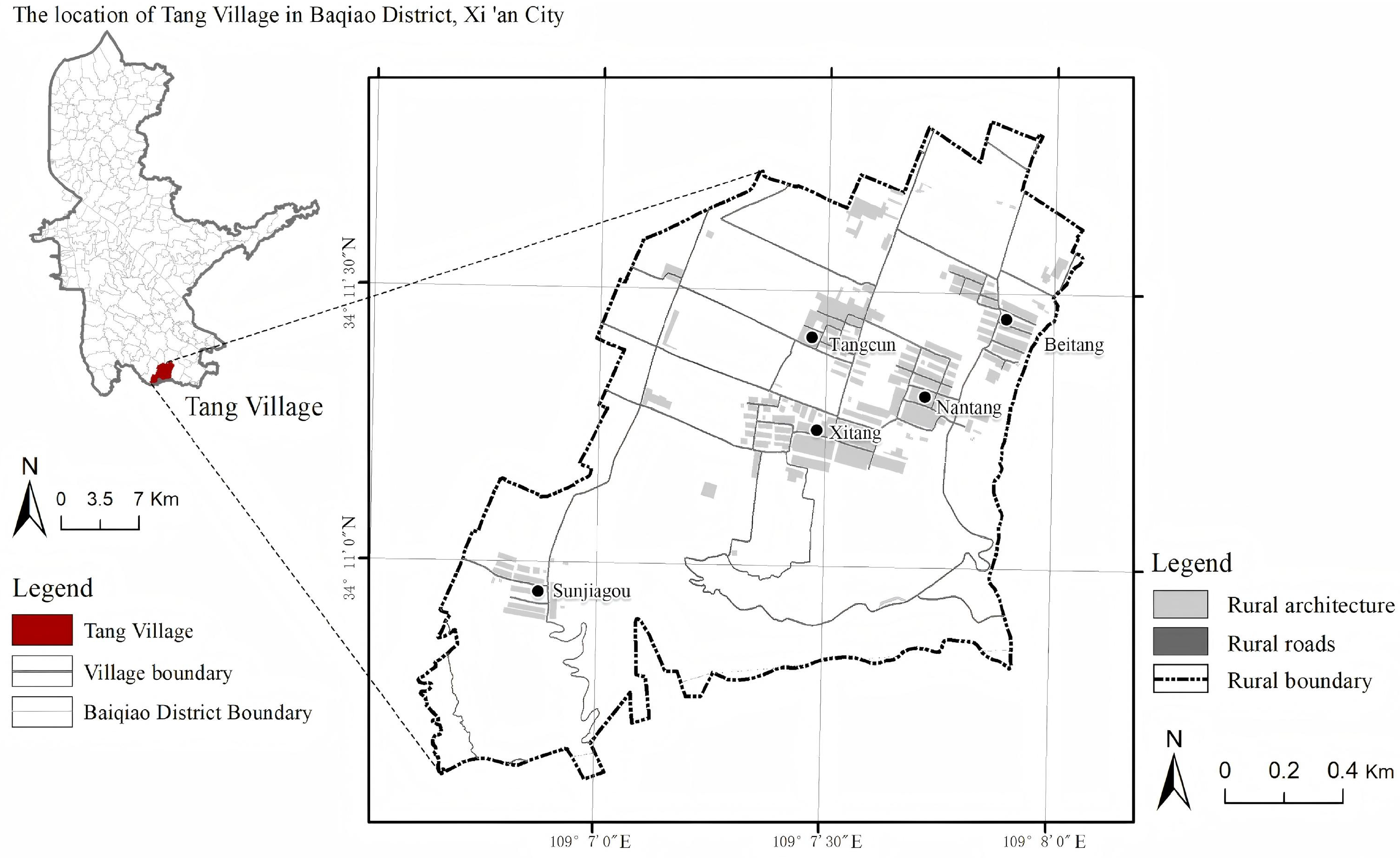
Tangcun area, historically referred to as “Santang Village”, is strategically situated within the Baqiao District of Xi’an. It aligns with the northern periphery of Jingyu Ditch, facing Paoli Town in the Chang’an District across the ravine to the south. Spanning a total area of 2.6 km2, the village encompasses a construction footprint of 37.4 hectares. Attributed to the pronounced geomorphological diversity of the region, the Tangcun area is categorized into five distinct village clusters based on their topographical positioning: the Sunjiagou cluster is nestled within a valley; the Xitang and Nantang clusters are distributed across primary slopes; and the Tangcun and Beitang clusters are located on the loess tableland, the most prevalent terrain of the Bailu Plain (Figure 1). Each cluster exhibits significant heterogeneity in resource endowment, spatial morphology, and developmental foundations, while simultaneously sharing collective requirements for coordinated industrial, infrastructural, and aesthetic integration. Consequently, this region represents a prototypical geomorphological village cluster.
As a traditional peri-urban agricultural zone, the Tangcun area serves as a representative microcosm for examining the complex interplay between geographical location, natural environment, and socio-economic dynamics in a metropolitan fringe. It is also an area where RLE construction challenges are particularly pronounced. Preliminary research indicates that clusters within this region frequently encounter systemic issues, including suboptimal housing conditions, inequitable distribution of public services, and fragmented planning implementation. Therefore, there is an imperative need to elucidate the specific environmental dilemmas facing each cluster and propose targeted, synergistic optimization strategies to facilitate the comprehensive revitalization of metropolitan-fringe villages.
The dataset for this study comprises socio-economic indicators and fundamental spatial construction data. Socio-economic data were synthesized from regional statistical yearbooks, official bulletins of the Bailuyuan Tangcun area, and supplemented by the latest comprehensive territorial and specialized planning documents. Primary data regarding construction conditions were garnered through extensive field surveys, semi-structured interviews, and structured questionnaires to ensure a holistic representation of the local context.

3.2. Research Framework

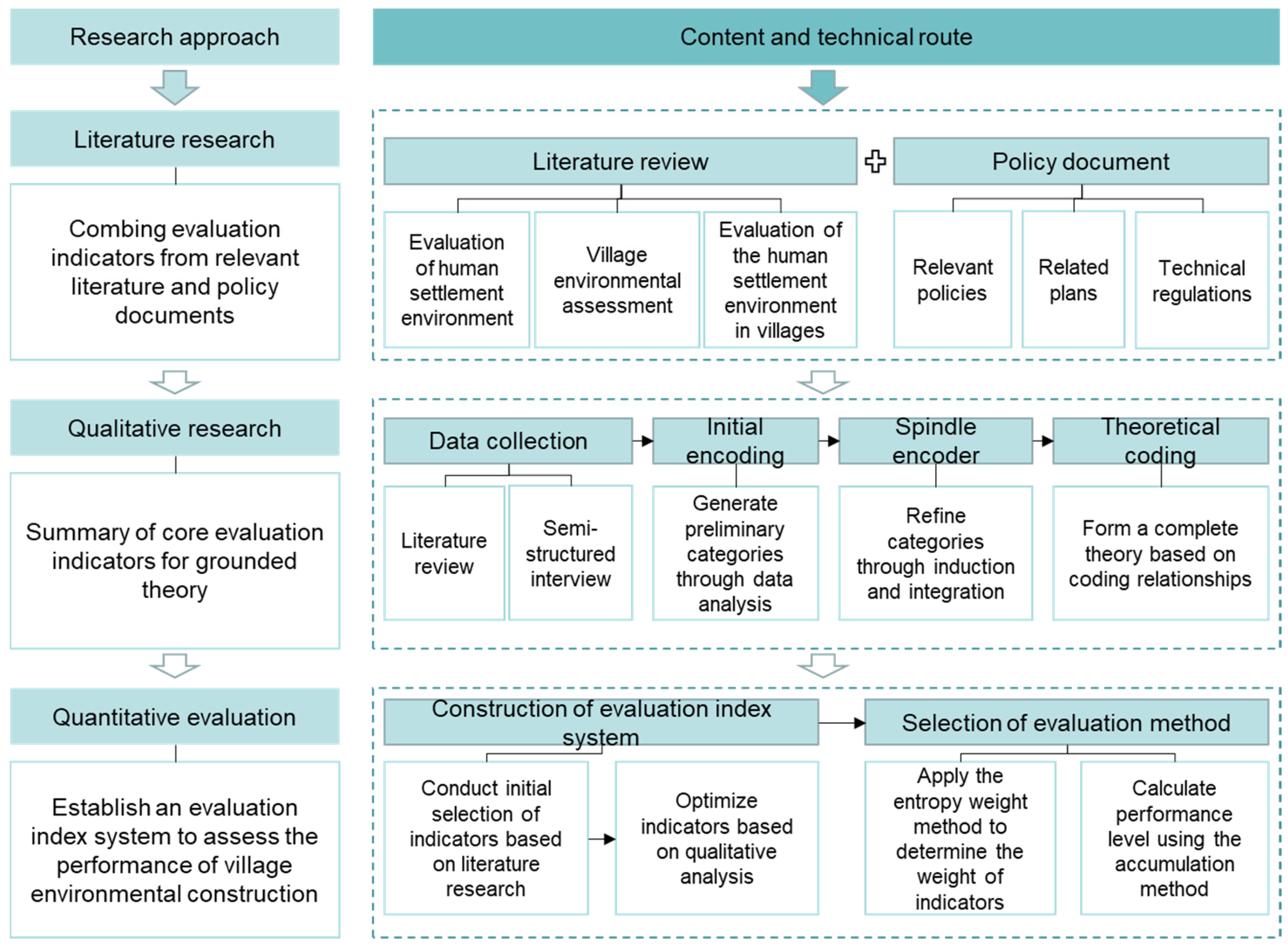
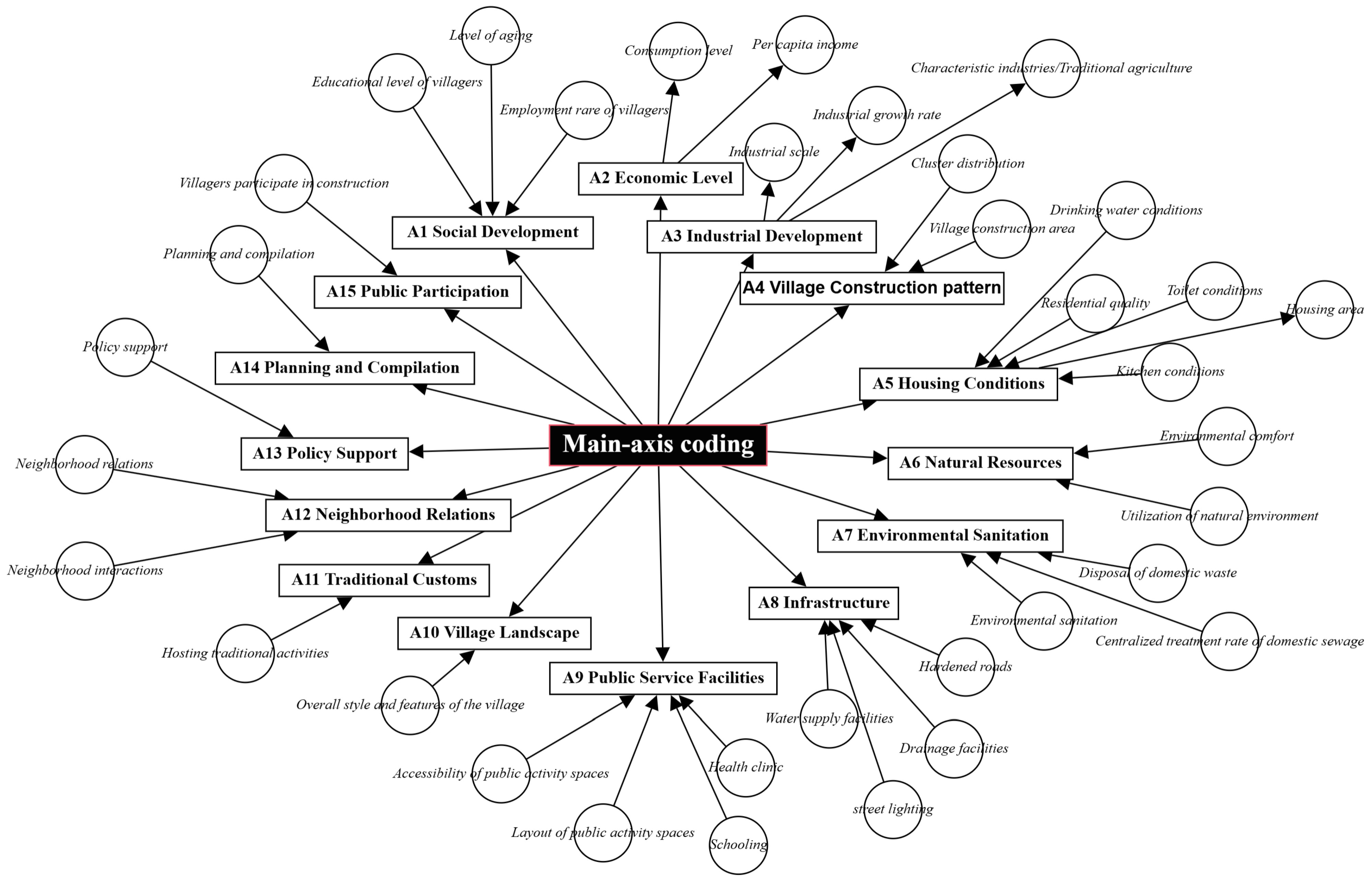
This research employs grounded theory combined with qualitative research methods to conduct a systematic analysis of RLE construction in Tangcun clusters. Primary qualitative data were collected through semi-structured interviews targeting a triangulated stakeholder cohort, including grassroots administrators, local business entities, and villagers. Following the principles of open and axial coding, the interview transcripts were parsed to distill 15 primary categories (Figure 2, Table 2). These categories include social development, economic vitality, industrial structure, village spatial patterns, land-use efficiency, housing quality, natural resource management, environmental sanitation, infrastructure, public services, architectural style, cultural heritage, social cohesion (neighborhood relations), policy support, and public participation. This qualitative induction provided the theoretical foundation for the subsequent quantitative evaluation framework.

3.3. Data Collection and Preliminary Processing Process

3.3.1. Semi-Structured Interview and Sample Selection

This study employed semi-structured interviews as the primary data collection method, conducted in public spaces, streets, and farmers’ residences in Tangcun area. Each interview lasted a minimum of 30 min, and all interviews were audio-recorded with prior consent and transcribed verbatim for subsequent analysis.
Interviewees were purposively sampled to cover all key stakeholders of village environmental construction, divided into three distinct groups:
  • Three administrative staff members from the Tangcun Committee and the Dizhai Sub-district Office, whose interviews focused on overall construction planning, implementation progress, and management mechanisms.
  • Four local economic actors, including convenience store owners, tourism project managers, and agricultural industrial park employees, who provided insights into the impacts of environmental improvement on local livelihoods and business operations.
  • Twenty-three village residents, comprising 6 commuters who worked outside the village during daytime and 17 permanent residents, whose interviews centered on emerging issues during construction and their satisfaction with current outcomes.
The diversity of interviewees ensured data triangulation, completeness, and complementary perspectives. Most participants had lived and worked in Tangcun area for extended periods, providing in-depth, experiential insights into local development. Strict confidentiality protocols were maintained throughout the research process to establish trust and ensure the reliability and validity of the collected data.

3.3.2. Grounded Theory Analysis and Data Preprocessing

The qualitative data analysis strictly followed the four-step grounded theory methodology: open coding, axial coding, selective coding, and theoretical saturation testing.
First, open coding involved conceptualizing and categorizing raw transcript data through iterative decomposition and recombination to identify phenomena, define concepts, and extract core categories. During initial data screening, materials irrelevant to the research topic, containing exaggerated claims, or lacking clear thematic focus were excluded. Preliminary concepts such as “building quality”, “permanent population”, “public space”, “ecological environment”, and “daily communication” were extracted directly from interview transcripts, resulting in 56 initial concepts that were subsequently aggregated into 35 basic categories.
Second, axial coding systematically reorganized seemingly independent categories to establish logical connections and reveal the organic relationships within the dataset. Through repeated comparative analysis and refinement, 15 main categories were identified: social development, economic level, industrial development, village construction pattern, land use, housing conditions, natural resources, environmental sanitation, infrastructure, public service facilities, village landscape, traditional customs, neighborhood relations, policy support, planning formulation, and public participation.
Third, selective coding identified core categories that could comprehensively summarize and unify related main categories. Repeated verification ensured the generalizability and dominance of core categories over their subordinate dimensions, maximizing theoretical coverage and forming a coherent analytical framework. Building on the 15 main categories, 6 core dimensions of village environmental construction were extracted: socio-economic background, residential environment construction, natural environment conservation, public facility development, cultural landscape preservation, and planning and governance.
Finally, theoretical saturation was verified by analyzing four additional follow-up interviews. No new categories or concepts emerged during this process, confirming that data analysis had reached theoretical saturation and justifying the termination of sampling.
Drawing on urban and rural planning terminology and grounded theory principles, the 6 core dimensions were further decomposed into 20 specific performance evaluation elements, which formed the basis for constructing the village environmental construction performance evaluation index system (Table 3, Figure 3).

3.4. Development of the Performance Evaluation Framework

3.4.1. Construction of the Indicator System

Integrating established urban–rural planning taxonomies with the insights derived from grounded theory, the evaluation framework was conceptualized into six primary dimensions: Socio-economic Context, Residential Environment, Natural Environment, Public Facilities, Cultural and Aesthetic Identity, and Planning Management [40,41]. These dimensions were further decomposed into 20 s level indicators and corresponding measurable evaluation factors, calibrated to reflect the unique characteristics of village environmental construction in the Tangcun area.
The hierarchical structure of the indicator system is presented in Table 4. To ensure the objectivity and comparability of evaluation results, the relative importance of each indicator was determined using the Analytic Hierarchy Process (AHP), as detailed in the following section.

3.4.2. Indicator Weight Calculation Using AHP

The AHP mainly constructs a hierarchical structure model to systematically and hierarchically process problems, decomposing complex problems into multiple constituent elements. These constituent elements form several levels according to their relationship attributes, and finally present three levels: the objective layer, the criterion layer, and the indicator layer. Among them, the target layer is the expected goal of analyzing the problem, the criterion layer is the standard used for evaluating and selecting solutions, and the indicator layer is the specific measurable indicators for implementation. A hierarchical structure model was established based on the research problem, followed by the construction of judgment matrices for each level, hierarchical sorting, consistency verification, and final normalization to obtain the weight vector.
This study adopted the AHP to calculate the weights of evaluation indicators and invited 10 experts (including 5 urban–rural planning scholars, 3 local government officials in charge of rural construction, and 2 village representatives with rich practical experience) to conduct independent scoring. This multi-stakeholder expert team ensured the scientificity, rigor, objectivity, and credibility of the weight calculation results.
The general steps of using the AHP are to first construct a judgment matrix, then perform hierarchical single sorting and hierarchical total sorting, perform consistency testing again and consider whether to reconstruct the judgment matrix, and finally normalize to obtain the weight vector (Formulas (1)–(6)).
By calculating the maximum eigenvalue λ m a x of the judgment matrix B = ( b i j ) a a then calculate the unit eigenvector corresponding to λ m a x which is the weight vector required in hierarchical single sorting.
Firstly, normalize each column of the judgment matrix:
b ¯ i j = b i j i = 1 n b i j ( i , j = 1,2 , n )
Secondly, sum the normalized judgment matrices of each column by row:
W ¯ i = j = 1 n b ¯ i j ( j = 1,2 , n )
Thirdly, normalize W ¯ = ( W ¯ 1 , W ¯ 2 , W ¯ n ) T :
W i = W ¯ i i = 1 n W ¯ i
Finally, calculate the maximum eigenvalue:
λ m a x = i = 1 n ( A W ) i n W i
In the formula, ( A W ) i represents the i-th component of vector AW.
Then, perform consistency checks:
C R = i = 1 m b i C I i / i = 1 m b i R I i
among which:
C I = λ m a x n n 1
In the formula, R I is the average random consistency index. A C R < 0.1 indicates that the judgment matrix has satisfactory consistency.
Based on the above AHP calculation steps and the independent scoring results of 10 experts, the judgment matrices for the system layer (B layers) and indicator layer (C layer) were constructed respectively, and the weight calculation and consistency test were completed. The results showed that all judgment matrices passed the consistency test, with CR values ranging from 0.021 to 0.075 (all less than 0.1), indicating that the expert judgment was consistent and reliable. The final weights of all evaluation indicators, calculated through normalization, are presented in Table 4.

3.4.3. Data Normalization

To ensure the robustness and comparability of the evaluation findings, the raw data were subjected to standardization to eliminate dimensional disparities among diverse indicators. This study adopts the min–max normalization method to scale the indicator values into a dimensionless range of [0, 1]. The specific formulas are as follows (Formulas (7) and (8)):
For positive indicators (where higher values indicate better performance):
X i j = X i j m i n ( X 1 , X 2 , , X i ) m a x ( X 1 , X 2 , , X i ) m i n ( X 1 , X 2 , , X i )
For negative indicators (where lower values indicate better performance):
X i j = m a x ( X 1 , X 2 , , X i ) X i j m a x ( X 1 , X 2 , , X i ) m i n ( X 1 , X 2 , , X i )
In these equations, X i j represents the normalized value of the j -th indicator for the i -th evaluation unit, while X i j denotes the raw observation. m a x ( X j ) and m i n ( X j ) correspond to the maximum and minimum values of the j -th indicator across all units, respectively.

3.4.4. Comprehensive Performance Assessment

Based on the calculated weights and normalized contributions, the overall spatial performance index ( A ) for village environmental construction in the Tangcun area was derived using a linear weighted accumulation model (Formula (9)):
A = i = 1 n w i C i ( i = 1,2 , 3 , , n )
In the formula, A represents the comprehensive performance score, w i represents the weight of the i -th indicator, and Ci represents the contribution of the i -th indicator. A higher value of A correlates with a more advanced level of RLE construction performance in the Bailuyuan Tangcun area.

4. Result Analysis and Optimization Strategy

4.1. General Performance Assessment

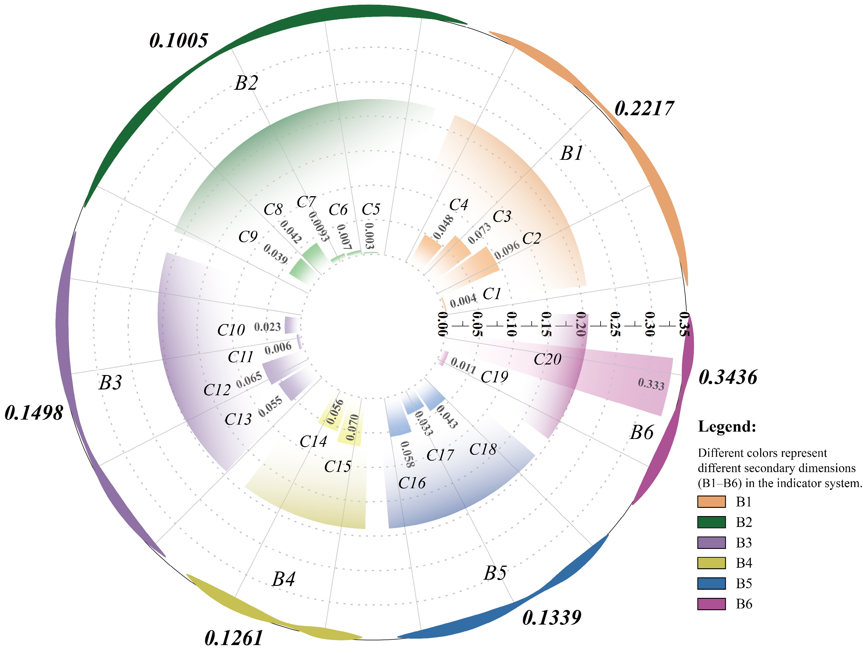
Based on the integrated evaluation framework, a comprehensive assessment of RLE construction performance in the Tangcun area was conducted. To categorize performance levels, the classification was carried out in accordance with the grade standards specified in Table 5. The empirical findings reveal that the overall performance of RLE construction in the Tangcun area is suboptimal, reflecting a significant disparity between current conditions and the synergistic requirements of regional clustering (Table 5, Figure 4).
A pronounced imbalance is observed among the six primary subsystems. The performance of the four subsystems of landscape construction, planning management, residential environment, and natural environment is significantly lower than the comprehensive performance, which is the core weakness of the environmental construction in the area; the performance of the two subsystems of socio-economic background and public facility construction is relatively high, but has not yet reached the “average” level.
  • From a granular perspective, these performance deficiencies are intrinsically linked to the lack of cluster-scale coordination:
  • Socio-economic Context: The low score of social development indicators is mainly due to the lack of top-level coordinated planning for the industrial development of various village clusters in the area, which directly lowers the overall performance of the subsystem.
  • Cultural Identity: The performance of village style indicators is relatively weak, which intuitively reflects that the existing cultural resources in the area have not been integrated and revitalized across clusters, and the construction of cultural style is fragmented, without relying on cluster development to form a distinctive cultural identity and inheritance system.
  • Planning Management: The performance of planning and development indicators is at the bottom, fully reflecting the lack of deep public participation in the entire process of grouping planning and implementation in the construction process of the district, and the insufficient pertinence and implementation of planning management.
  • Residential environment construction: The residential environment subsystem focuses on the daily living quality of villagers, but the performance of village construction pattern indicators is relatively low. The core problem lies in the lack of unified collaborative scheduling in spatial pattern planning between clusters, which has obvious shortcomings and blind spots.
  • Natural environment subsystem: The performance level of green construction indicators is relatively low, reflecting the lack of unified planning and maintenance of green facilities within the cluster, which affects the living environment of villages.
  • Public facility construction subsystem: The performance of infrastructure indicators is relatively low, with various infrastructure layouts biased towards local clusters. The overall sharing and inclusiveness of the area are insufficient, and high-quality facility resources are difficult to radiate and share across clusters, further exacerbating the development gap between clusters and constraining the overall improvement of the performance of the public facility subsystem.

4.2. Cluster-Scale Performance Disparities

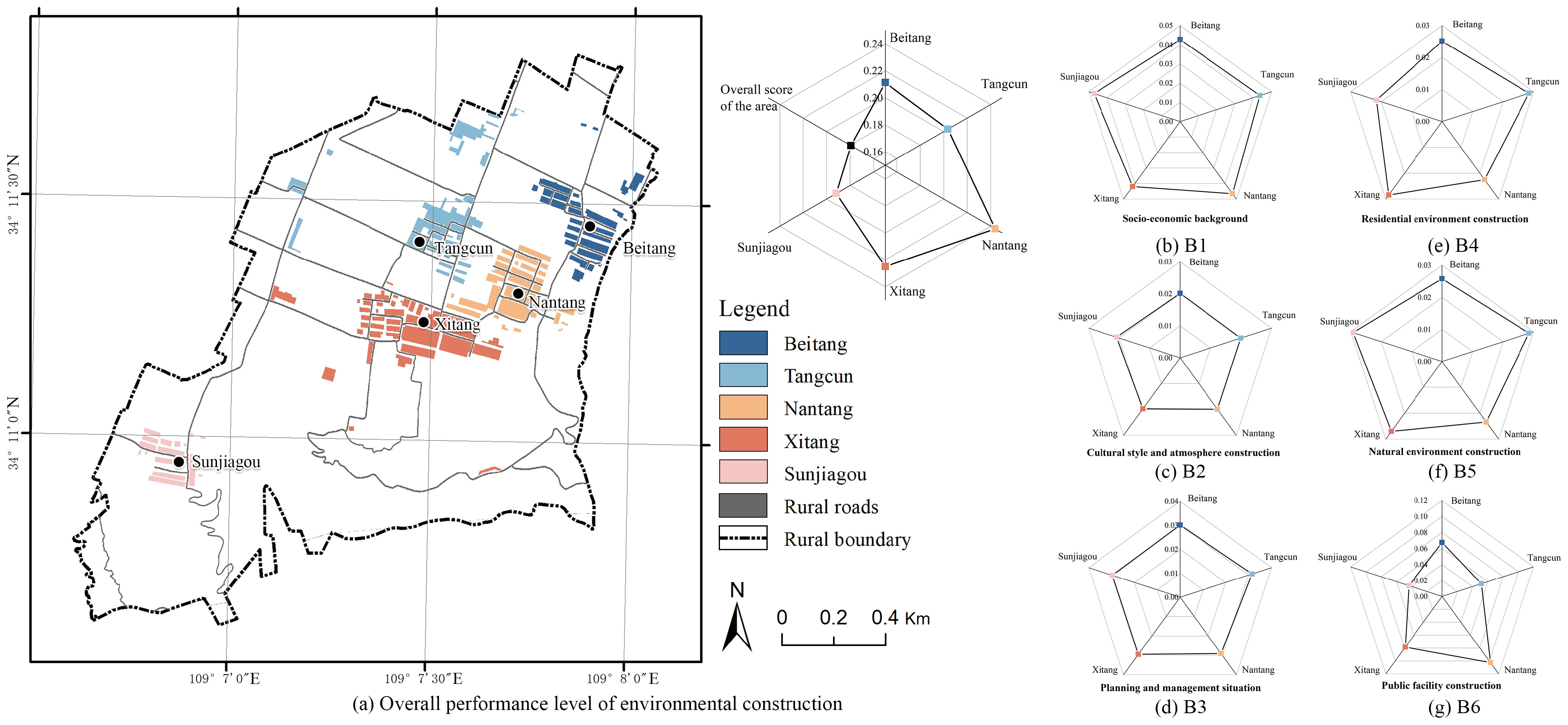
Regarding the comprehensive performance of individual village clusters, the Sunjiagou cluster exhibits the most significant deficiency. The region displays a distinctive topographical gradient in RLE performance, following a hierarchy of “Tableland > Slope > Gully” clusters. This spatial divergence directly contradicts the strategic goal of “complementary advantages and coordinated development” envisioned for regional clustering (Figure 5).
Subsystem performance analysis further reveals an overall evolutionary pattern characterized by non-material convergence and material differentiation.
In terms of non-material convergence, three core non-material subsystems—socio-economic foundation, rural cultural landscape construction, and township–village planning and management—exhibit only minor performance disparities across different clusters, while remaining at an overall low level. This indicates that these aspects constitute common weak links across the entire Tangcun area. It also reflects insufficient top-level design and implementation in industrial linkage, cultural co-construction, and integrated planning during cluster development. Meanwhile, the cross-cluster collaborative governance mechanism remains imperfect, failing to fully release the benefits of coordinated development.
In contrast, material construction subsystems dominated by public service and supporting facilities show striking score disparities and clear hierarchical differentiation among clusters. This phenomenon directly reflects the unbalanced allocation of public resources and the uneven spatial layout of facility supply in the Tangcun clustered development. High-quality resources are largely concentrated in superior clusters, and a radiation-driven development model from strong clusters to weak ones has not yet taken shape. Furthermore, cross-cluster joint construction, resource sharing, and optimal reallocation of public services and infrastructure have not been effectively realized.
Further analysis from the dimension of group differences in specific evaluation indicators reveals that industrial development, public facility allocation, environmental sanitation improvement, and other highly dependent on cross group coordinated layout and collaborative construction of outward-oriented indicators have significant performance gaps and uneven development issues among different groups; housing conditions, village style, and other indicators that rely on the village’s own basic endowment and belong to the endogenous development attributes of the village, the development gap between clusters is relatively flat, and the overall performance tends to be similar. This difference pattern further confirms that the core crux of the village environment construction and cluster development in the Bailuyuan Tangcun area of Xi’an is not the large gap in the basic conditions of individual villages, but the insufficient coordination and allocation of cross-cluster resources, poor coordination and connection of functional division of labor, and the lack of mechanisms for sharing public services and infrastructure, which have constrained the overall improvement of the living environment and the balanced and coordinated development of the entire area.

4.3. Identification of Systemic Performance Bottlenecks

Based on the performance evaluation results and field research findings, the core issues in the environmental construction of villages in the Tangcun area are insufficient cluster collaboration, imbalanced resource allocation, extensive planning and management, and weak development momentum.
Firstly, inequitable resource distribution and a lack of facility-sharing mechanisms. The allocation of infrastructure and public service facilities within the area is based on administrative villages, without overall planning and layout according to the spatial logic of cluster formation in the area. At the same time, the mechanism for joint construction and sharing of facilities at the area level has not yet been established, resulting in low utilization rates of facilities, difficult maintenance, and difficulty in meeting the needs of villagers in various clusters.
Secondly, administrative-centric planning with poor localized implementation. The planning for villages within the area still takes individual villages as the compilation unit, and the planning content lacks comprehensive consideration of the resource endowments and development needs of each cluster. There is a phenomenon of “imitation and copying”, which is inconsistent with the geographical conditions and cluster characteristics of the area.
Thirdly, decoupled ecological and cultural construction lacks regional identity. The natural environment remediation of each group within the area is carried out independently, and a collaborative mechanism for cross-group ecological protection and environmental sanitation remediation has not yet been established. At the same time, traditional customs and local culture of Bailuyuan are scattered within the area, and there is a lack of systematic cultural inheritance across groups. The integration of cultural resources and the shaping of characteristics at the regional level are insufficient, failing to form a cultural style pattern where “each group has its own characteristics and the overall area is distinctive”.
Lastly, embryonic governance mechanisms and insufficient stakeholder engagement. The environmental construction in the area is still led by the government, and a cluster-based multi-stakeholder co-governance mechanism has not yet been formed. The willingness and ability of multiple stakeholders such as village collectives, villagers, and business entities to participate are insufficient. Moreover, there is a lack of unified villager organizations and regional governance platforms. Public participation remains at the level of individual villages, and cross-cluster participation channels are not smooth. The mass foundation for cluster-based construction in the area is weak.

4.4. Optimization Path for Village Environment Construction in Tangcun Area Under the Clustering Mode of Districts

4.4.1. Calibrating Regional Spatial Planning for Clustered Development

Within the framework of territorial spatial planning, it is imperative to transcend conventional administrative village boundaries and compile an “Integrated Environmental Construction Plan for Cluster Villages in the Tangcun Area”. By elevating the planning unit from isolated villages to integrated clusters, the region can achieve coordinated implementation and management, effectively bridging the gap between planning theory and clustering practice [42].
Adhering to the principles of ecological priority, adapting measures to local conditions, group collaboration, and being people-oriented, the Tangcun Committee organizes staff to visit villagers in each group, comprehensively collect their actual needs for housing, environment, facilities, and other aspects through questionnaire surveys, discussions, and exchanges, and establish a list of needs; they organically integrate the overall development goals of the area with the differentiated development needs of each cluster, avoiding the planning of “imitation and copying”; The planning content highlights the systematic and collaborative nature of environmental construction in the area, clarifies the functional positioning, construction focus, and collaborative requirements of each cluster in environmental construction, focuses on setting specific links for villagers to participate in planning, guarantees the voice of villagers as the core subject of village construction, and ensures that the planning meets the actual needs of villagers [43].
Furthermore, it is necessary to optimize the three-level spatial hierarchy of Area–Cluster–Village in accordance with regional geographical characteristics and clustering logic. This process strictly demarcates ecological protection redlines and village construction boundaries, so as to coordinate the layout of production, living and ecological spaces across clusters [44]. Led by the Natural Resources Bureau of Baqiao District, in conjunction with the Agriculture and Rural Affairs Bureau and the Ecological Environment Bureau, we will scientifically delineate the ecological protection red line, village construction boundary, and clarify the specific scope of ecological space, production space, and living space for each cluster. We will promote the intensive construction of Taiyuan clusters, led by village collectives, guide villagers to build houses in a centralized manner, rectify idle homesteads, and use them for the construction of public spaces or industrial supporting facilities to avoid the waste of land resources caused by scattered expansion. We will protect the traditional village layout and local style of each group, register and document the old houses and courtyards in the village, and achieve group coordination and characteristic display of spatial development in the area.
In addition, a sound implementation mechanism featuring district coordination, cluster advancement and village execution should be established to clarify the respective responsibilities of the Baqiao District Government, Dizhai Sub-district Office, Tangcun Committee and individual village clusters. The cluster-level spatial planning is incorporated into the overall Bailuyuan rural revitalization master plan, and aligned with territorial spatial planning and industrial development planning to ensure both rigid planning constraints and flexible implementation. A dynamic planning adjustment mechanism is also formulated to timely optimize planning contents in response to the evolving development realities of regional village clusters.

4.4.2. Facilitating Equitable and Synergistic Facility Allocation

Based on the principles of regional resource sharing, cluster complementarity, and efficient utilization, the strategy seeks to dismantle the barriers of administrative-based facility allocation. Infrastructure and public services should be coordinated according to the spatial logic of clustering to achieve cross-cluster optimization and address the prevalent issues of inequity and low utilization [45].
In terms of infrastructure development including water supply and drainage, sewage treatment, domestic waste disposal, rural roads and street lighting, a unified regional construction model with graded cluster matching and shared village access is adopted. At the district level, the sub-district office collaborates with environmental protection authorities to apply for project funding, construct small-scale sewage treatment plants and domestic waste transfer stations, and realize centralized pollution treatment across all clusters. Interconnected road networks between clusters are upgraded and expanded to enhance regional transportation accessibility. At the cluster level, led by village committees, supporting facilities such as water-drainage pipelines and street lamps are systematically deployed to ensure equitable service coverage, with targeted improvement of facility shortcomings in the Sunjiagou, Xitang and Nantang clusters [46].
Beyond infrastructure construction, public service facilities are arranged following the hierarchical logic of regional centers, cluster stations and village service points. The Tangcun core cluster is positioned as the primary regional public service hub, equipped with comprehensive facilities such as village clinics, cultural activity centers and elderly service stations. Secondary service stations with fitness and cultural functions are deployed in Xitang, Nantang and Sunjiagou clusters to guarantee convenient localized services. Basic livelihood services such as retail and express delivery are retained at the village level, ultimately forming a hierarchical, full-coverage and share-oriented public service layout system [47].

4.4.3. Advancing Collaborative Ecological Protection and Cultural Heritage

Aligned with the unique ecological and cultural identity of the Bailuyuan loess tableland, this initiative focuses on regional ecological co-governance and clustered cultural distinctiveness. It aims to achieve synergy in environmental remediation and foster a regional aesthetic that reflects both overall cohesion and cluster-specific identity [48].
It is essential to establish a cross-cluster collaborative mechanism for ecological remediation and joint environmental protection. Cross-unit ecological corridors are delineated to prioritize the protection of the Yu Valley water system and slope ecological landscape, forming an interconnected regional ecological protection pattern. Unified environmental sanitation standards and joint remediation actions are implemented across clusters, alongside targeted cluster greening layout. Tableland clusters focus on constructing farmland shelterbelts and forest networks, while slope clusters prioritize slope ecological restoration, and gully clusters emphasize water system ecological greening, jointly shaping a complete and layered regional ecological security pattern.
On the basis of ecological governance, scattered cultural resources of Bailuyuan are integrated with the characteristic cultural endowments of each cluster to form a systematic cultural inheritance system and build a unified regional cultural brand for the Tangcun area. Distinct cultural positioning is highlighted at the cluster level: Tangcun and Beitang clusters focus on inheriting traditional farming culture; Xitang and Nantang clusters emphasize slope homestay and leisure culture; Sunjiagou clusters take valley ecological culture as their core feature. This differentiated layout maintains the overall regional cultural prominence while retaining localized characteristics, and is further reinforced by regular cross-cluster cultural exchange activities.
Furthermore, unified village style and aesthetic guidelines are formulated for the Tangcun area, specifying unified requirements for architectural style, facade color and building materials to maintain overall regional spatial coordination. In accordance with topographic differences, differentiated architectural shaping is guided: tableland clusters inherit the orderly layout of traditional Guanzhong rural residences, while slope and gully clusters advocate organic integration of buildings with natural terrain. Local Bailuyuan cultural elements are embedded into public space design to strengthen the overall regional identity and cultural cohesion.

4.4.4. Constructing a Multi-Stakeholder Regional Clustering Governance Framework

Guided by public governance and collaborative governance theories, this study constructs a cross-administrative governance framework following the logic of government guidance, regional coordination, cluster autonomy and diversified participation, which provides institutional guarantee for the sustainable development of village environmental construction [49,50].
A hierarchical regional governance platform is first established under the leadership of the Baqiao District Rural Revitalization Bureau and Dizhai Sub-district Office. A Regional Cluster Council is set up with representatives from the Tangcun Committee, cluster leaders, village residents, market entities and local rural elites, undertaking responsibilities for overall regional coordination, planning formulation and effect evaluation. Correspondingly, each village cluster sets up an autonomous management group responsible for implementing specific environmental construction projects, forming a complete three-tier governance system of Regional Council–Cluster Autonomous Group–Villager Representatives.
Meanwhile, diversified participation channels are expanded to fully mobilize village collectives, individual villagers, market enterprises and hometown elites to engage in cluster environmental construction. A special public participation platform is launched to collect public opinions and suggestions through village assemblies, cluster seminars and online feedback channels. Incentive policies are formulated to attract hometown elites, professional technicians and skilled talents to participate in regional construction, providing technical guidance and financial support for cluster development. Rural market entities are also encouraged to invest in and operate regional public facilities, realizing government–enterprise cooperation and mutual benefits between villages and market players.
To sustain long-term operation, a complete set of supervision, assessment and incentive mechanisms is formulated for clustered environmental construction. Assessment indicators covering industrial development, facility improvement, ecological remediation, cultural inheritance and resident satisfaction are decomposed and assigned to each cluster. Organized by the Regional Cluster Council, assessment results are closely linked to policy support and financial fund allocation. Honor recognition and material rewards are granted to outstanding clusters, active villagers and contributing market entities to mobilize the enthusiasm of all stakeholders. In addition, a problem feedback and rectification system is established with online and offline channels, enabling timely response and solutions to practical problems arising in the process of regional clustered environmental construction.

5. Conclusions and Discussion

5.1. Conclusions

This study investigated the Tangcun area of Bailuyuan by constructing a comprehensive performance evaluation index system for village environmental construction across six primary subsystems. By quantitatively analyzing the performance characteristics at both the regional and cluster scales, this research proposed targeted optimization pathways from a clustering perspective. The primary conclusions are summarized as follows:
  • The overall performance of Rural Living Environment (RLE) construction in the Tangcun area is suboptimal, characterized by significant developmental imbalances across the six subsystems. The Socio-economic Context and Planning Management constitute the core bottlenecks. These deficiencies are intrinsically linked to the fragmented coordination among regional clusters, which hinders the optimized cross-boundary allocation of resources.
  • RLE performance across the Tangcun clusters exhibits pronounced spatial heterogeneity. The performance of the Sunjiagou cluster is significantly lower than that of its counterparts. Furthermore, subsystem performance demonstrates a pattern of “convergence in intangible dimensions and differentiation in tangible dimensions”. This reflects a systemic failure to implement integrated cluster development in terms of industry, planning, and infrastructure sharing.
  • The optimization of village environmental construction under the clustering model must strictly adhere to the principles of “integrated planning, resource consolidation, functional complementarity, and coordinated development”. A systematic framework should be constructed across five dimensions: cluster-based industrial growth, spatial recalibration, equitable facility allocation, ecological–cultural co-governance, and collaborative governance mechanisms. This transition is essential to shift the paradigm from “isolated village improvement” to “synergistic regional enhancement”.

5.2. Implications, Limitations and Future Research Directions

By focusing on the metropolitan-fringe tableland areas, this research enriches the empirical scholarship on RLE performance evaluation under the regional clustering model. The developed evaluation index system and the proposed optimization pathways offer a valuable reference for similar peri-urban regions facing developmental fragmentation.
However, several limitations persist that warrant further investigation. Firstly, the geographical scope of this study is confined to the Bailuyuan Tangcun area. Future research could expand this scope to conduct comparative analyses across diverse rural typologies to test the universality of the clustering model. Secondly, this study did not provide a quantitative prediction of the implementation effects of the proposed optimization paths. Future studies could integrate methods such as scenario simulation or System Dynamics (SD) modeling to further evaluate the long-term feasibility and impact of these strategies [51].
In the context of the national Rural Vitalization Strategy, the clustering paradigm remains a pivotal approach for achieving high-quality, systematic rural development. Future research and practice should further strengthen the theoretical guidance of urban-rural planning by transcending administrative fragmentation. It is imperative to coordinate resources and planning at the cluster scale while fully accounting for the unique geomorphological features, resource endowments, and developmental baselines of different regions. By formulating differentiated cluster strategies, we can facilitate the deep integration of environmental construction and regional development, ultimately achieving the comprehensive revitalization of the RLE.

Author Contributions

Conceptualization, methodology, X.F. and P.Z.; software, B.Y.; validation, X.F. and Z.L.; investigation, resources, data curation, B.Y. and X.F.; writing—original draft preparation, B.Y. and X.F.; writing—review and editing, X.F. and Z.L.; visualization, Z.L.; supervision, project administration, funding acquisition, X.F., and P.Z. All authors have read and agreed to the published version of the manuscript.

Funding

This research was funded by Shaanxi Provincial Department of Education 2025 Annual Scientific Research (Program No. 25JK0119), Shaanxi Provincial Science and Technology Plan Project (2025JC-YBMS-486) and Research Project for the 2025 Annual Talent Introduction Fund of Xi’an Fanyi University (Program No. 2025Y02).

Institutional Review Board Statement

The study was conducted in accordance with the Declaration of Helsinki, and approved by Review Committee of the Faculty of Economics and Management, Xi’an Fanyi University, on 3 April 2026.

Informed Consent Statement

Informed consent was obtained from all subjects involved in the study.

Data Availability Statement

The data that support the findings of this study are available on request from the corresponding author due to privacy or ethical restrictions.

Conflicts of Interest

Mr. Baokun Yang is affiliated with Shangluo Branch Company, Shaanxi Agricultural Development Group Co., Ltd., Xi’an 710075, China. All authors declare that the research was conducted entirely in the absence of any commercial, financial, or personal relationships that could be construed as a potential conflict of interest.

Abbreviations

RLERural Living Environments
AHPAnalytic Hierarchy Process
SDSystem Dynamics

References

  1. Ma, Y.; Han, D.; Qiao, J.; Ma, J.; Ma, Y.; Wang, Z.; Guo, P.; Hui, X.; Xu, J. Evaluating the quality of rural human settlements and the perception of farm households—A case study of traditional agricultural areas in China. Habitat Int. 2026, 170, 103724. [Google Scholar] [CrossRef]
  2. Lu, P.; Wang, X. Dilemmas and Countermeasures in Rural Human Settlement Environment Governance. Agric. Econ. 2025, 10, 63–65. [Google Scholar]
  3. Chen, L.; Zhong, Q.; Li, Z. Analysis of spatial characteristics and influence mechanism of human settlement suitability in traditional villages based on multi-scale geographically weighted regression model: A case study of Hunan province. Ecol. Indic. 2023, 154, 110828. [Google Scholar] [CrossRef]
  4. Ren, L.; Dong, X.; Xu, Y.; Yang, S. Resilience Characteristics and Influencing Factors Analysis of Rural Human Settlement Environment System in Ecologically Fragile Areas: A Case Study of the Loess Plateau in Northern Shaanxi. Chin. J. Agric. Resour. Reg. Plan. 2025, 46, 24–41. [Google Scholar]
  5. Wu, L. Introduction to Human Settlements Environmental Science; China Architecture & Building Press: Beijing, China, 2001.
  6. Wang, P.; Qin, X.; Li, Y. Satisfaction evaluation of rural human settlements in northwest China: Method and application. Land 2021, 10, 813. [Google Scholar] [CrossRef]
  7. Liao, M.L.; Li, M. Theoretical logic, typical models, and institutional arrangements for promoting rural revitalization through regionalization. Contemp. Econ. Manag. 2026, 1–12. Available online: https://link.cnki.net/urlid/13.1356.F.20260303.1625.004 (accessed on 11 May 2026).
  8. Xu, T.T.; Ban, Y.C.; Hong, Z.; Zheng, R. Research on the Collaborative Path of Village Environmental Governance and Green Development under the Background of Rural Ecological Revitalization: A Case Study of Tianxing Village Cluster in Shou’an Town. Rural Econ. Sci.-Technol. 2022, 33, 28–31. [Google Scholar]
  9. Xu, C.X.; Lan, J. Research on the Construction and Revitalization Path of Village and Town System from the Perspective of District Cluster. Prog. Geogr. 2025, 44, 117–130. [Google Scholar]
  10. Li, G.Y.; Sun, X.R. From “Surface Participation” to “Deep Participation”: Difficulties and Path Optimization of Public Participation in Rural Planning: A Case Study of Daciyan Town, Hangzhou City. Urban Plan. Forum 2025, S1, 54–59. [Google Scholar] [CrossRef]
  11. Luo, W.; Ma, Y.L.; Song, X.Y.; Liu, C.; Chen, J.; Lu, Y.; Yang, W. Application of ArcGIS Model Builder in Village Planning and Compilation. Geomat. Spat. Inf. Technol. 2026, 49, 181–184. [Google Scholar]
  12. Feng, C.L.; Du, W.Q. Regional and clustered management: Practical innovation of resident cadres leading the development of rural industries. J. Nanjing Agric. Univ. (Soc. Sci. Ed.) 2026, 26, 155–167. [Google Scholar] [CrossRef]
  13. Cheng, P.K.; Hu, S.G.; Zhang, P. Exploration and Practice of Planning for Agglomeration and Upgrading Villages in Northwest China: A Case Study of Y Village in Ningxia Hui Autonomous Region. Nat. Resour. Econ. China 2021, 34, 31–39. [Google Scholar] [CrossRef]
  14. Song, J.; Chang, F.; Wen, S.Q. Spatial Differences between Traditional Rural Settlements and Planned Settlements in Northwest China: A Case Study of Songshan Town, Tianzhu County, Gansu Province. Dev. Small Cities Towns 2019, 37, 96–102+108. [Google Scholar]
  15. Wang, Y.F.; Li, T.T.; Meng, X.T. Evaluation and Evolution Characteristics of Rural Living Environment Quality in China from 2010 to 2020. Geogr. Res. 2022, 41, 3245–3258. [Google Scholar]
  16. Dai, J.; Ma, Y.Y.; Wu, W. Evaluation and Collaborative Optimization of Rural Living Environment in Jiangsu Province from the Perspective of Rural Revitalization. Jiangsu Agric. Sci. 2021, 49, 1–9. [Google Scholar] [CrossRef]
  17. Li, J. Construction and Empirical Study of Evaluation Indicator System for Rural Human Settlement Environment. Stat. Decis. 2023, 39, 97–101. [Google Scholar] [CrossRef]
  18. Wang, K.; Feng, Y.; Zhang, Y. The Development Process, Logic, and Outlook of Rural Human Settlement Environment after Reform and Opening up. City Plan. Rev. 2022, 46, 77–86. [Google Scholar]
  19. Shi, Y.; Huang, Y.; Hu, D.; Cai, H.; Xiang, M.; Zhang, R. Historical Context, Evolutionary Characteristics, and Methodological Exploration of Rural Human Settlement Environment Construction. Urban Rural Plan. 2022, 4, 61–69. [Google Scholar]
  20. Yu, F. Rural Residential Environment Improvement under the Rural Revitalization Strategy. Stud. Social. With Chin. Charact. 2019, 2, 80–85. [Google Scholar]
  21. Conzen, M.P. Spatial Data from Nineteenth Century Manuscript Censuses: A Technique for Rural Settlement and Land Use Analysis. Prof. Geogr. 1969, 21, 337–343. [Google Scholar] [CrossRef]
  22. Preston, D.A. New Towns—A Major Change in the Rural Settlement Pattern in Highland Bolivia. J. Lat. Am. Stud. 1970, 2, 1–27. [Google Scholar] [CrossRef]
  23. Neave, S.A. Rural Settlement Contraction in the East Riding of Yorkshire c. 1660–1760 with Particular Reference to the Bainton Beacon Division; University of Hull: Hull, UK, 1990. [Google Scholar]
  24. Zhao, W. The Experience of Living in a Concentrated Community—Understanding of Human Settlement Environment Space and Place. J. Hum. Settl. West China 2020, 35, 116–124. [Google Scholar] [CrossRef]
  25. Zhan, D.S.; Zhang, W.Z.; Dang, Y.X.; Yu, J.H. Analysis of the Supporting Conditions for the Human Settlement Environment in China’s Urbanization Development. Hum. Geogr. 2015, 30, 98–104. [Google Scholar] [CrossRef]
  26. Deng, T.; Cai, J. Comprehensive Evaluation and Spatial Differentiation of Rural Human Settlement Environment: A Case Study of Yongjing County, Gansu Province. J. Southwest Univ. (Nat. Sci. Ed.) 2024, 46, 100–114. [Google Scholar] [CrossRef]
  27. Zhang, Y.N.; Zhu, H.Y.; Ouyang, H.X.; Song, L.L. Evaluation of Sustainable Development Level and Spatial Pattern of Rural Human Settlement Environment in the Yangtze River Economic Belt. Resour. Ind. 2022, 24, 42–54. [Google Scholar] [CrossRef]
  28. Qi, T. Research on Technical Models and Development Trends of Rural Human Settlement Environment Construction in Southwest China. Planners 2021, 37, 73–81. [Google Scholar]
  29. Xu, S.; Liu, X.; Xiao, Y.; Zhang, L. Evaluation of Rural Human Settlement Development Quality and Impact Analysis: Empirical Evidence from China’s Micro Survey? Land 2025, 14, 780. [Google Scholar] [CrossRef]
  30. Yang, X.; Wang, Q. Evaluation and Impact Analysis of Rural Human Settlement Environmental Quality in Southern Anhui Tourism Area. Acta Geogr. Sin. 2013, 68, 851–867. [Google Scholar]
  31. Wang, C.; Li, H.; He, Y.; Ma, X.; Zhou, M. Research on the Sustainable Development Capacity of Rural Human Settlement Environment and Its Spatial-Temporal Differentiation since Chongqing Becoming a Municipality Directly Under the Central Government. Prog. Geogr. 2019, 38, 556–566. [Google Scholar]
  32. Wang, Q.; Wu, J.; Bian, Z. Evaluation of Village-level Human Settlement Environment based on Entropy Weight Method from the Perspective of Rural Revitalization. Agric. Econ. 2020, 395, 36–37. [Google Scholar]
  33. Li, B.; Yang, S.; Liu, P.; Tian, Y.P. Research on Dynamic Assessment and Optimization Countermeasures of Rural Human Settlement Environment-Taking Hunan Province as an Example. J. Hengyang Norm. Univ. 2010, 6, 71–76. [Google Scholar] [CrossRef]
  34. Li, B. Research on the Evolution of Farmers’ Spatial Behavior and the Optimization of Rural Human Settlement Environment; Science Press: Beijing, China, 2014.
  35. Sun, Z. Research on the Evaluation and Evolution of Rural Human Settlement Environment Level in Guangxi under the Background of Rural Revitalization. Chin. J. Agric. Resour. Reg. Plan. 2025, 46, 142–152. [Google Scholar]
  36. Zhou, L.; Ren, Z. Research on the Natural Suitability of Human Settlement Environment in the Guanzhong Region Based on GIS. Resour. Dev. Mark. 2011, 27, 160–163+96. [Google Scholar]
  37. Li, X. Research on Planning Strategies for Rural Human Settlement Environment Improvement in the Guanzhong Region. Master’s Thesis, Xi’an University of Architecture and Technology, Xi’an, China, 2018. [Google Scholar]
  38. Yang, H.; Zhang, P. Research on the Performance Evaluation and Sustainable Development Model of Rural Construction in Guanzhong Region; China Architecture & Building Press: Beijing, China, 2021.
  39. Chang, H.; Wang, S. Evaluation of Rural Human Settlement Environmental Quality in Village Areas on the Loess Plateau: A Case Study of the Northwest Part of Zizhou County. Rural Econ. Sci.-Technol. 2019, 30, 27–30. [Google Scholar]
  40. Shi, X.; Su, P.; Xia, Y.; Zhang, H.; Shen, Y.; Faye, B.; Wang, Y.; Liu, L.; Xue, R. Assessing Rural Habitat Suitability in Anhui Province: A Socio-Economic and Environmental Perspective. Sustainability 2025, 17, 2825. [Google Scholar] [CrossRef]
  41. Chen, X.; Rong, F.; Li, S. Driving Force–Pressure–State–Impact–Response-Based Evaluation of Rural Human Settlements’ Resilience and Their Influencing Factors: Evidence from Guangdong, China. Sustainability 2024, 16, 813. [Google Scholar] [CrossRef]
  42. Wang, Y.; Pei, X.; Lai, C. Research on Strategies for Rural Revitalization in Areas Rich in Characteristic Villages under the Background of Territorial Spatial Planning: A Case Study of Qiandongnan Miao and Dong Autonomous Prefecture, Guizhou Province. Dev. Small Cities Towns 2023, 41, 35–44. [Google Scholar]
  43. Lu, H.; Wang, J.; Wu, L. Theoretical logic, Practical Dilemmas, and Practical Paths of Promoting Common Prosperity through Cluster Development in Rural Areas. J. Shanxi Agric. Univ. (Soc. Sci. Ed.) 2026, 1–11. Available online: https://link.cnki.net/urlid/14.1305.C.20260306.0959.005 (accessed on 27 March 2026).
  44. Yang, L.S.; Wang, N.; Zhao, J. Measures for the Village Construction and Sustainable Development of Environment: Take the Planning of Beiwu Village Shanhaiguan District as an Example. Adv. Mater. Res. 2013, 663, 265–269. [Google Scholar] [CrossRef]
  45. Li, S.; Yu, C.; Tian, K. Research on the Allocation and Layout of Public Service Facilities in Traditional Villages in Binhai, Shandong. Des. Community 2021, 6, 146–154. [Google Scholar]
  46. Wu, Q.; Zhang, Q.; Wu, S. From Beautiful Villages to Harmonious Villages: Theoretical Logic and Planning Response for Contiguous Development of County-level Villages. Planners 2025, 41, 17–24. [Google Scholar]
  47. Zhou, N.; Zhang, J.; Zhou, C. Research on Contiguous Development of Villages in the Context of Rural Revitalization: A Case Study of Beijing. Dev. Small Cities Towns 2025, 43, 111–118. [Google Scholar]
  48. Jin, Q. Research on Collaborative Strategies for Rural Ecological Security and Sustainable Development Based on Bottom-Line Control and Operational Empowerment: A Case Study of the Territorial Space Planning for Lianyi Village-Level Area in Chongzhou City. Archit. Cult. 2025, 8, 134–137. [Google Scholar] [CrossRef]
  49. Zhao, M.; Niu, L.; Huang, Y. Evaluation of the Quality of Rural Human Settlement in Yunnan-Guizhou-Guangxi Adjoining Areas and Study on Pluralistic Governance. Sci. Rep. 2025, 15, 33715. [Google Scholar] [CrossRef]
  50. Yin, Y.C.; Wang, J.; Wang, Y.Q.; Liu, X.; He, Y.; Jiang, J.; Zhang, D.L.X. Research on the Regionalized Development Model of Rural Areas under the Goal of Collaborative Governance: A Comparison based on Three Typical Cases in Changsha City. Urban Environ. Des. 2026, 2, 37–42. [Google Scholar] [CrossRef]
  51. Shuai, D.; Haiying, Y. A Deep Learning Big Data-Based Satisfaction Assessment Method for Rural Habitat Improvement. Int. J. High Speed Electron. Syst. 2025, 2540607. [Google Scholar] [CrossRef]
Figure 1. Diagram of research object and scope. Source: Drafted by the authors.
Sustainability 18 05403 g001
Figure 2. Research framework design.
Sustainability 18 05403 g002
Figure 3. Main-axis coding results. Source: Drafted by the authors.
Sustainability 18 05403 g003
Figure 4. Distribution of village environmental construction performance in Tangcun area. Source: Drafted by the authors.
Sustainability 18 05403 g004
Figure 5. Comparative assessment of comprehensive RLE performance among five village clusters in Tangcun area. Source: Drafted by the authors.
Sustainability 18 05403 g005
Table 1. Comprehensive evaluation index system for RLE.
Target LayerSystem LayerIndicator Level
A harmonious and sustainable living environment for humans and natureRural ecological
environment
Natural landscape types and quantity
Natural disaster losses
Per capita green area
Air quality
Comprehensive evaluation index of surface water
Garbage and human and animal excreta treatment rate
Township industrial emission compliance rate
Rural settlement
environment
Per capita water
Electricity consumption
Penetration rate of home television and telephone
Supply and demand situation of hydropower
Rural settlement
conditions
Rural population density
Per capita living space
Building density
Proportion of Class I and Class II residential land
Social environment of
rural communities
Distance from the central town or urban service area
Number of schools
Per capita medical resources
Per capita area of public land
Life expectancy per capita
Number of times per capita participating in recreational activities
Economic conditions
of rural communities
The proportion of income from rural tourism
Per capita annual GDP
The structure and employment proportion of the three
major industries
Agriculture and non-agricultural labor productivity
Annual disposable income of rural residents
The ability of rural areas to
accommodate people in
concentrated settlements
The educational level of individual residents
Household labor force status
The growth potential of
rural areas
The progressiveness of the industry
Innovation and application of production technology
Sustainability of
rural areas
Annual growth rate of fixed assets
Annual growth rate of residential investment
Annual growth rate of environmental protection investment
The contribution rate of technology in economic growth
Growth rate of public infrastructure investment
Table 2. Interview outline.
Serial NumberQuestion
01How long have you been living in the village? Could you briefly share your connection with this village?
02During your residence, at what times and in what aspects have improvements been made in the village that left a deep impression on you (such as enhancing the appearance and overall condition of the village, improving the quality of houses, popularizing infrastructure, etc.)?
03It is understood that Tangcun has undergone continuous upgrading and renovation in recent years. Do you think the village has changed significantly? What aspects of the changes have left a deep impression on you? Why?
04When were the buildings in the village constructed? How has the construction of new houses in the village progressed in recent years? Has there been significant change in the spatial layout of the village?
05What characteristics do you think the natural environment of Tangcun has? Have there been any
changes in recent years?
06After the improvement and upgrading of the village, do you think it has become more suitable for living? In what aspects?
07Have the improved villages caused any inconvenience to your daily life? Or are there any construction and renovations that you consider meaningless or unnecessary?
08What aspects of construction do you think the village currently lacks (such as public activity spaces,
infrastructure, production facilities, etc.)?
09Has the improvement of village construction changed your daily life?
10When is the population of the village the largest? Why do you think there are fewer and fewer people
in the village nowadays?
11Are you familiar with the villagers who have moved out? What is your definition of them? In your
opinion, what are the differences between them and you?
12What are your thoughts on the neighborhood relations within the village? How have they
changed from before?
13Do you feel a sense of belonging to the village? Do you enjoy living in the village? Why?
14If your economic status improves and you can relocate to a more desirable urban area, would you still choose to live here? Why? If not, what attracts you most here?
15Do you know about the relevant planning for village construction? Is the planning well-prepared?
16To what extent, and through what mechanisms, have you been involved in the decision-making or
implementation of village construction projects?
Table 3. Correspondence between theoretical categories and evaluation indicators.
Main CategoryCore CategoriesEvaluation Indicators
Social development
Economic level
Industrial development
Socio-economic backgroundSocial development
Economic level
Industrial development
Urban–rural relationship
Village landscape
Traditional customs
Neighborhood relations
Cultural style and atmosphere
construction
Village landscape
Social ethos
Traditional customs
Neighborhood relations
Village rules and conventions
Policy support
Planning and compilation
Public participation
Planning and management situationPolicy support
Planning and compilation
Public participation
Village organization
Village construction pattern
Housing conditions
Residential environment constructionVillage construction pattern
Housing conditions
Natural resources
Greening construction
Natural environment constructionNatural resources
Greening construction
Environmental sanitation
Infrastructure
Public service facilities
Public facility constructionInfrastructure
Public service facilities
Table 4. Evaluation indicator system for RLE construction performance in the Tangcun area.
Target Layer
(A Layer)
System Layer (B Layer)Indicator Layer
(C Layer)
Evaluation FactorsIndicator Weight
Performance evaluation
of village
environmental construction (A)
Socio-economic background (B1)Social development
(C1)
Aging layer
The educational level of villagers
0.0574
Economic level
(C2)
Per capita income
Consumption layer
0.0841
Industrial
development
(C3)
Characteristic industries/Traditional agriculture0.0638
Urban–rural
relationship
(C4)
Non-agriculture employment ratio
Urban per capita disposable income/Net income per capita of farmers
0.0729
Cultural style and
atmosphere construction (B2)
Village landscape
(C5)
Satisfaction with village style and features0.0251
Social ethos
(C6)
Satisfaction with social atmosphere
Is there any capable person to lead
0.0249
Traditional customs
(C7)
The number of traditional events held in a year0.0170
Neighborhood
relations
(C8)
The degree of close interaction between neighbors
Satisfaction with neighborhood relations
0.0232
Village rules
and conventions
(C9)
Are there village regulations and civil agreements0.0221
Planning and management situation (B3)Policy support
(C10)
Satisfaction with policy support0.0342
Planning
and compilation (C11)
Satisfaction with planning and preparation0.0406
Public participation (C12)Villagers’ participation0.0303
Village organization (C13)Is there any villager organization
Number of village organizational activities in a year
0.0278
Residential
environmental construction (B4)
Village construction pattern
(C14)
Village construction area
Compactness index of village
0.0943
Housing conditions
(C15)
Living comfort
Residential construction quality
Satisfaction with toilet conditions
Satisfaction with kitchen conditions
Satisfaction with drinking water conditions
0.0656
Natural
environment construction (B5)
Natural resources
(C16)
Environmental comfort
Utilization rate of natural environment
0.0518
Greening
construction
(C17)
Satisfaction with greening construction0.0496
Environmental
sanitation
(C18)
Centralized treatment rate of domestic sewage
Household waste disposal situation
Overall satisfaction with environmental sanitation
0.0591
Public facility construction (B6)Infrastructure
(C19)
Per capita paved road length
Satisfaction with street lamp settings
Satisfaction with water supply facilities
Satisfaction with drainage facilities
0.0562
Public service
facilities
(C20)
Accessibility of public activity space
Per capita area of public activity space
Is there a clinic
Convenience of children’s schooling
0.1002
Total1.0000
Note: This table presents the hierarchical indicator system for village environmental construction performance evaluation, adopting a standardized alphanumeric coding scheme where A denotes the target layer, B denotes the system layer, and C denotes the indicator layer.
Table 5. Classification standards for rural living environment (RLE) performance levels.
Score<0.2[0.2–0.4)[0.4–0.6)[0.6–0.8)≥0.8
LevelRangePoorGeneralGoodExcellent
Disclaimer/Publisher’s Note: The statements, opinions and data contained in all publications are solely those of the individual author(s) and contributor(s) and not of MDPI and/or the editor(s). MDPI and/or the editor(s) disclaim responsibility for any injury to people or property resulting from any ideas, methods, instructions or products referred to in the content.