Assessing Degradation Risk of Geosites in the Safi Province (Marrakesh–Safi Region, Morocco)



Abstract
1. Introduction

2. Materials and Methods
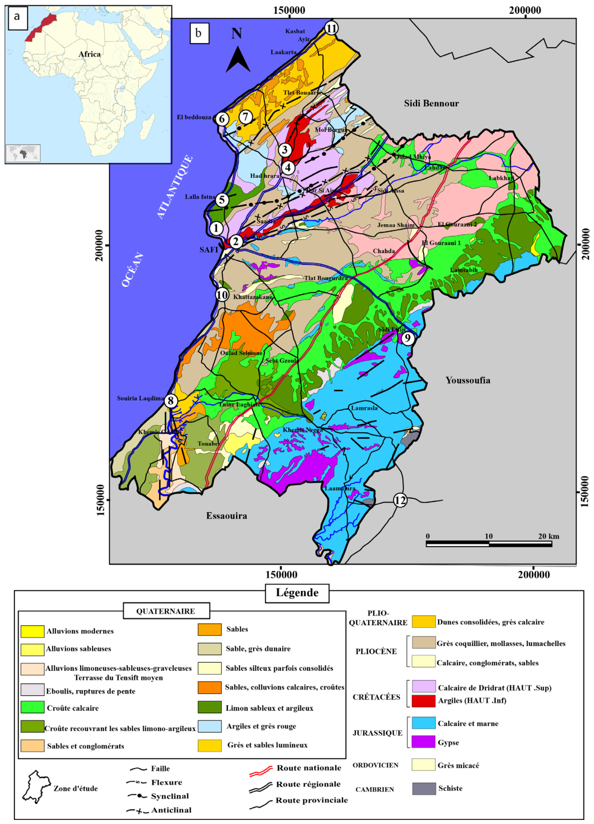
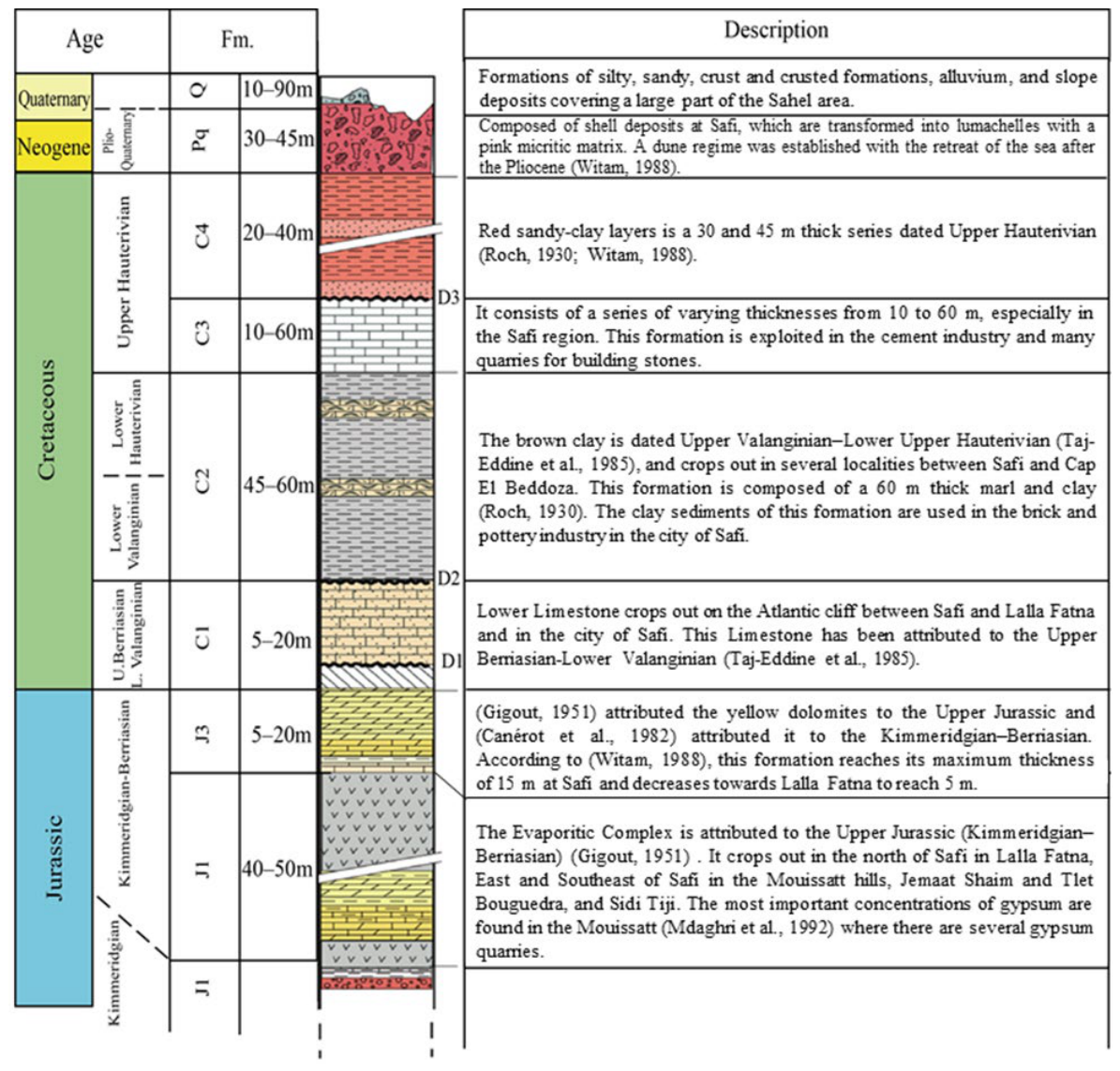
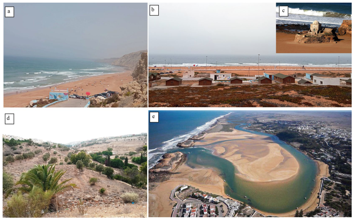
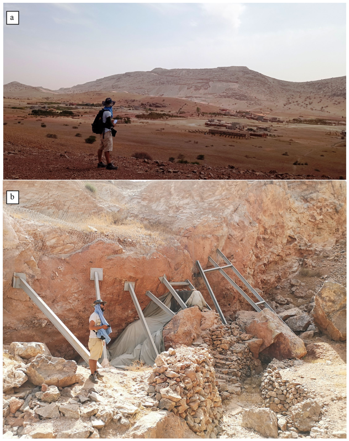
2.1. Geological and Geographic Settings
2.2. Methods
Quantitative Assessment of Geosites Degradation Risk
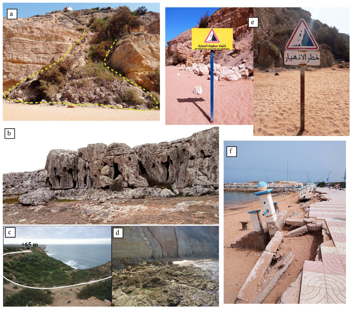
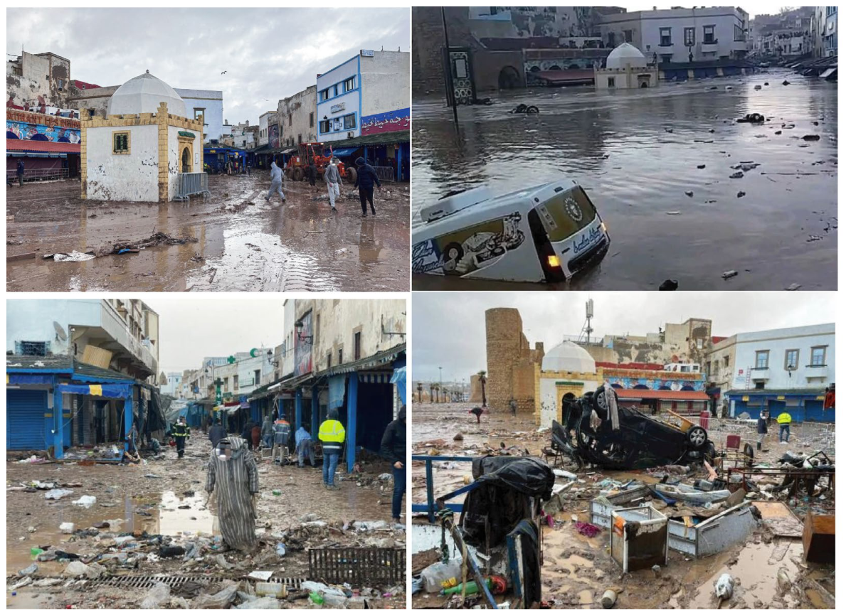
- Active processes. This parameter considers natural processes that do not directly contribute to the formation of the geosite but may affect its integrity. These processes can have geological, climatic, or biological origins, and identifying them is essential to evaluating potential degradation [14]. Geological processes include gravity-induced movements, water erosion, and weathering. Biological processes involve both fauna, such as trampling and burrowing, and flora, including root growth and expansion of surface vegetation. Climatic processes require long-term data collection and include temperature, humidity, precipitation, wind, flooding, and meteorological and marine factors. It is also important to determine whether these natural extrinsic processes operate continuously or episodically. Accordingly, active sites are classified as active-continuous or active-episodic, depending on whether the processes occur year-round or during short recurrent periods [57]. Scoring is assigned as follows: 0 for sites unaffected by extrinsic processes, 1 for sites affected by episodic processes, 2 for sites affected by constant processes, and 3 for sites affected by two or more extrinsic processes.
- Proximity. This parameter assesses the geosite’s proximity to areas susceptible to degradation from active natural processes, such as coastal erosion, volcanic activity, or landslides. Scores are assigned as follows: 0 for sites with no potential degradation areas, 1 and 2 for sites near 1 or 2 active processes, respectively, and 3 for sites adjacent to areas with more than 2 potential degradation processes.
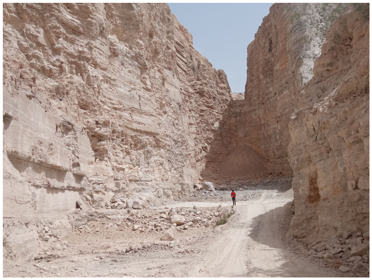
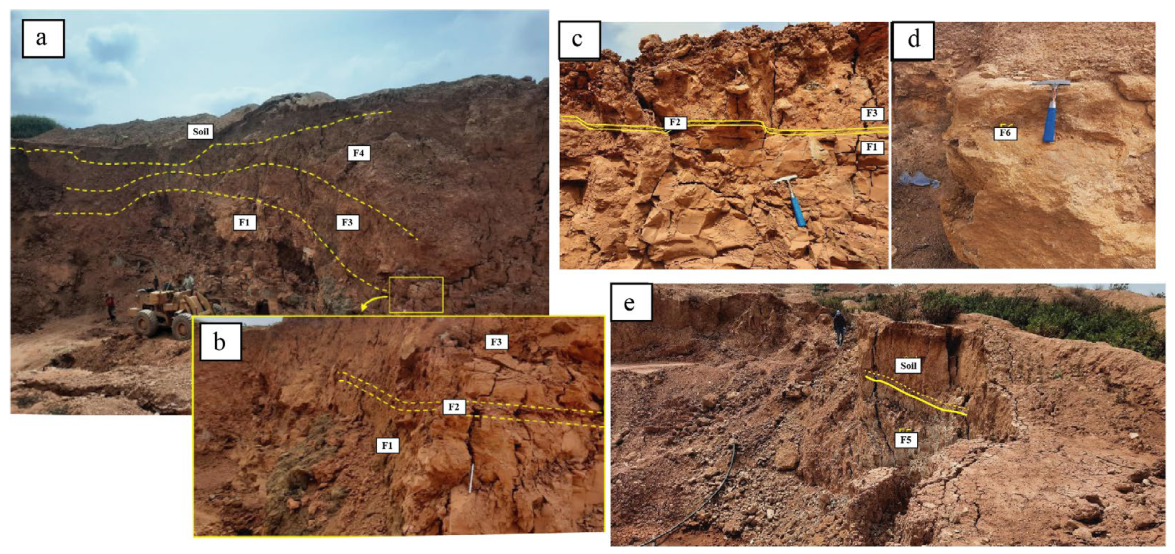
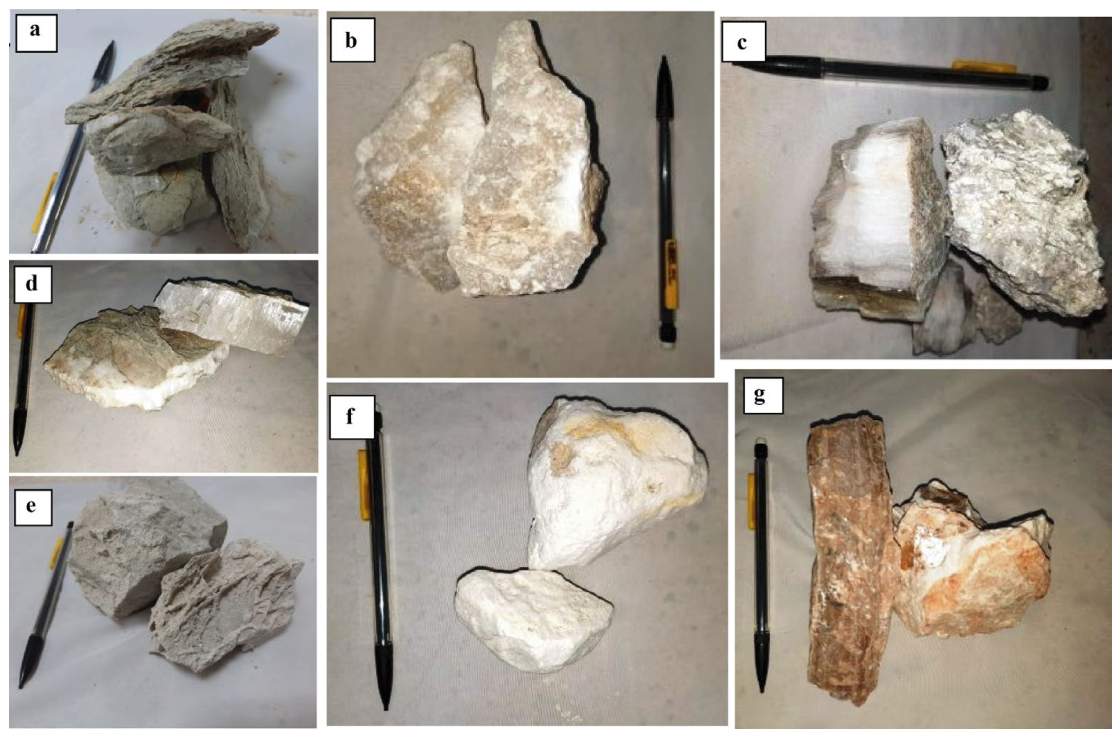
- Economic interest. This parameter reflects the occurrence of geological features with economic value, including those that are currently exploited or have the potential for exploitation through quarrying or mining activities.
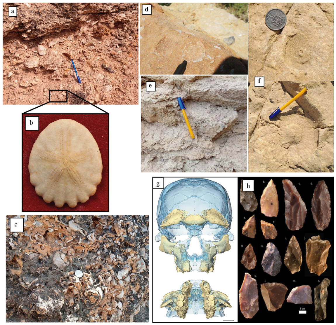
- Private interest. This parameter considers the presence of geological collectibles, such as fossils and minerals, which may be subject to uncontrolled or unregulated collection and misuse. While not always strictly illegal, depending on national legislation and its enforcement, such activities can still lead to geosite degradation [58,59]. In Morocco, the legal framework and its enforcement remain limited, increasing site vulnerability.
- Legal protection. Evaluates whether the geosite is legally protected due to geological, cultural, historical, or environmental value.
- Human proximity. Measures the distance from human activities that could potentially damage the site.
- Accessibility. Assesses ease of access, as more visitors increase the risk of damage.
- Population density. Higher concentrations of people living near the site raise the likelihood of human-induced degradation.
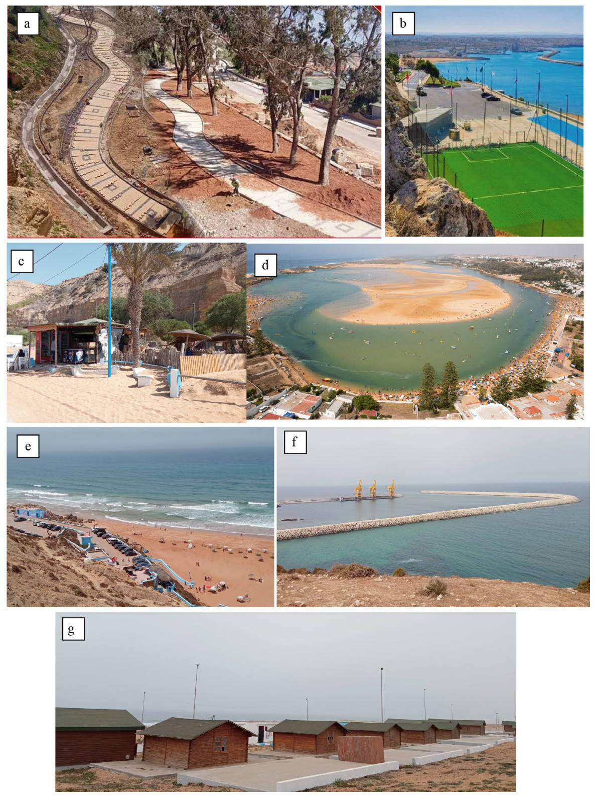
- Physical protection. Considering the presence of barriers or structures (e.g., fences, stairs, walkways) that limit direct contact with the public.
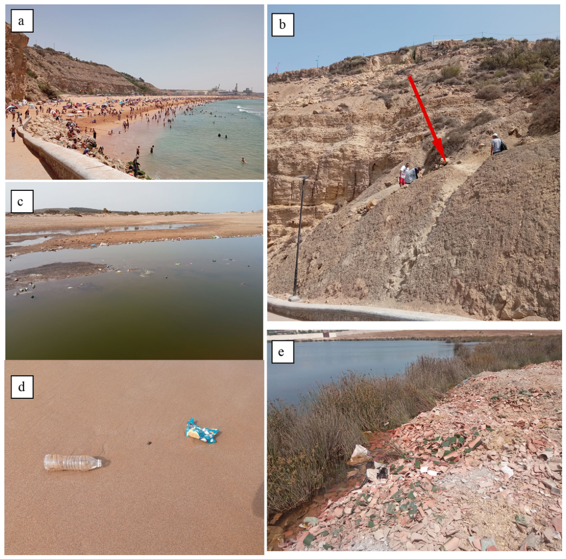
- Degrading use. Evaluates improper public use, such as littering or vandalism.
- Control of access. Assesses measures such as patrols, surveillance cameras, or other monitoring strategies.
3. Results
4. Discussion
5. Conclusions
Author Contributions
Funding
Institutional Review Board Statement
Informed Consent Statement
Data Availability Statement
Acknowledgments
Conflicts of Interest
References
- Prosser, C.D.; Díaz-Martínez, E.; Larwood, J.G. The conservation of geosites: Principles and practice. In Geoheritage: Assessment, Protection, and Management, 2nd ed.; Elsevier: Amsterdam, The Netherlands, 2026; pp. 341–360. [Google Scholar] [CrossRef]
- Gordon, J.E.; Crofts, R.; Díaz-Martínez, E. Geoheritage conservation and environmental policies: Retrospect and prospect. In Geoheritage: Assessment, Protection, and Management, 2nd ed.; Elsevier: Amsterdam, The Netherlands, 2026; pp. 361–390. [Google Scholar] [CrossRef]
- Coratza, P.; Bollati, I.M.; Panizza, V.; Brandolini, P.; Castaldini, D.; Cucchi, F.; Deiana, G.; Del Monte, M.; Faccini, F.; Finocchiaro, F.; et al. Advances in Geoheritage Mapping: Application to Iconic Geomorphological Examples from the Italian Landscape. Sustainability 2021, 13, 11538. [Google Scholar] [CrossRef]
- Reynard, E. The Assessment of Geomorphosites. In Geomorphosites; Reynard, E., Coratza, P., Regolini-Bissig, G., Eds.; Pfeil: Munchen, Germany, 2009; pp. 63–71. [Google Scholar]
- Brilha, J. Geoheritage: Inventories and Evaluation. In Geoheritage: Assessment, Protection, and Management, 1st ed.; Reynard, E., Brilha, J., Eds.; Elsevier: Amsterdam, The Netherlands, 2018; pp. 69–86. [Google Scholar]
- Coratza, P.; Hobléa, F. The Specificities of Geomorphological Heritage. In Geoheritage: Assessment, Protection, and Management, 1st ed.; Reynard, E., Brilha, J., Eds.; Elsevier: Amsterdam, The Netherlands, 2018; pp. 87–106. [Google Scholar]
- Mucivuna, V.C.; Garcia, M.G.M.; Reynard, E. Comparing quantitative methods on the evaluation of scientific value in geosites: Analysis from the Itatiaia National Park, Brazil. Geomorphology 2022, 396, 107988. [Google Scholar] [CrossRef]
- Lima, F.F.; Brilha, J.B.; Salamuni, E. Inventorying geological heritage in large territories: A methodological proposal applied to Brazil. Geoheritage 2010, 2, 91–99. [Google Scholar] [CrossRef]
- Brilha, J. Património Geológico e Geoconservação: A Conservação da Natureza na sua Vertente Geológica; Palimage Editores: Viseu, Portugal, 2005. [Google Scholar]
- Pereira, P.; Pereira, D.; Caetano, M.I. Geomorphosite assessment in Monteshino Natural Park (Portugal). Geogr. Helv. 2007, 62, 159–168. [Google Scholar] [CrossRef]
- Carcavilla, L.; López-Martínez, J.; Durán, J.J. Patrimonio Geológico y Geodiversidad: Investigación, Conservación, Gestión y Relación con los Espacios Naturales Protegidos; Instituto Geológico y Minero de España: Madrid, Spain, 2007. [Google Scholar]
- Fuertes-Gutiérrez, I.; Fernández-Martínez, E. Geosites inventory in the Leon Province (Northwestern Spain): A tool to introduce geoheritage into regional environmental management. Geoheritage 2010, 2, 57–75. [Google Scholar] [CrossRef]
- Fassoulas, C.; Mouriki, D.; Dimitriou-Nikolakis, P.; Iliopoulus, G. Quantitative assessment of geotopes as an effective tool for geoheritage management. Geoheritage 2012, 4, 177–193. [Google Scholar] [CrossRef]
- Bollati, I.M.; Crosa Lenz, B.; Caironi, V. A multidisciplinary approach for physical landscape analysis: Scientific value and risk of degradation of outstanding landforms in the glacial plateau of the Loana Valley (Central-Western Italian Alps). Ital. J. Geosci. 2020, 139, 233–251. [Google Scholar] [CrossRef]
- García-Ortiz, E.; Fuertes-Gutiérrez, I.; Fernández-Martínez, E. Concepts and terminology for the risk of degradation of geological heritage sites: Fragility and natural vulnerability, a case study. Proc. Geol. Assoc. 2014, 125, 463–479. [Google Scholar] [CrossRef]
- Brilha, J. Inventory and quantitative assessment of geosites and geodiversity sites: A review. Geoheritage 2016, 8, 119–134. [Google Scholar] [CrossRef]
- IPCC. AR5 Synthesis Report: Climate Change 2014; Contribution of Working Groups I, II and III to the Fifth Assessment Report of the Intergovernmental Panel on Climate Change; Pachauri, R.K., Meyer, L.A., Eds.; IPCC: Geneva, Switzerland, 2014; 151p. [Google Scholar]
- IPCC. Climate Change and Land; An IPCC Special Report on Climate Change, Desertification, Land Degradation, Sustainable Land Management, Food Security, and Greenhouse Gas Fluxes in Terrestrial Ecosystems; Shukla, P.R., Skea, J., Buendia, E.C., Masson-Delmotte, V., Pörtner, H.O., Roberts, D.C., Zhai, P., Slade, R., Connors, S., Van Diemen, R., et al., Eds.; IPCC: Geneva, Switzerland, 2019. [Google Scholar]
- Main, G.; Schembri, J.; Gauci, R.; Crawford, K.; Chester, D.; Duncan, A. The hazard exposure of the Maltese Islands. Nat. Hazards 2018, 92, 829–855. [Google Scholar] [CrossRef]
- Prosser, C.D.; Burek, C.V.; Evans, D.H.; Gordon, J.E.; Kirkbride, V.B.; Rennie, A.F.; Walmsley, C.A. Conserving geodiversity sites in a changing climate: Management challenges and responses. Geoheritage 2010, 2, 123–136. [Google Scholar] [CrossRef]
- Nicholls, R.J.; Cazenave, A. Sea-Level Rise and Its Impact on Coastal Zones. Science 2010, 328, 1517–1520. [Google Scholar] [CrossRef]
- Gray, M. Geodiversity: Valuing and Conserving Abiotic Nature, 2nd ed.; John Wiley & Sons: Chichester, UK, 2013; 495p. [Google Scholar]
- Gray, M. Geodiversity: A significant, multi-faceted and evolving, geoscientific paradigm rather than a redundant term. Proc. Geol. Assoc. 2021, 132, 605–619. [Google Scholar] [CrossRef]
- Meira, S.A.; Morais, J.O. Os conceitos de geodiversidade, patrimônio geológico e geoconservação: Abordagens sobre o papel da geografia no estudo da temática [The concepts of geodiversity, geological heritage and geoconservation: Approaches on the role of geography in the study of the theme]. Bol. Geogr. 2017, 11, 129–147. [Google Scholar] [CrossRef]
- Kubalíková, L.; Irapta, P.N.; Pál, M.; Zwoliński, Z.; Coratza, P.; Van Wyk de Vries, B. Visages of Geodiversity and Geoheritage: A Multidisciplinary Approach to Valuing, Conserving and Managing Abiotic Nature. In Visages of Geodiversity and Geoheritage; Geological Society, Special Publications: London, UK, 2023. [Google Scholar]
- Prosser, C.D.; Díaz-Martínez, E.; Larwood, J.G.H. Conservação de Geossítios: Princípios e Prática. In Geoheritage: Assessment, Protection, and Management, 1st ed.; Reynard, E., Brilha, J., Eds.; Elsevier: Chennai, India, 2018; pp. 193–221. [Google Scholar]
- Intergovernmental Panel on Climate Change (IPCC). Climate Change 2022: Impacts, Adaptation and Vulnerability; Contribution of Working Group II to the Sixth Assessement Report of the Intergovernmental Panel on Climate Change; Pörtner, H.-O.O., Roberts, D.C., Tignor, M., Poloczanska, E.S., Mintenbeck, K., Alegría, A., Craig, M., Langsdorf, S., Löschke, S., Möller, V., et al., Eds.; Cambridge University Press: Cambridge, UK, 2023; 3056p. [Google Scholar] [CrossRef]
- Selmi, L.; Canesin, T.S.; Gauci, R.; Pereira, P.; Coratza, P. Degradation Risk Assessment: Understanding the Impacts of Climate Change on Geoheritage. Sustainability 2022, 14, 4262. [Google Scholar] [CrossRef]
- Sarkar, N.; Rizzo, A.; Vandelli, V.; Soldati, M. A Literature Review of Climate-Related Coastal Risks in the Mediterranean, a Climate Change Hotspot. Sustainability 2022, 14, 15994. [Google Scholar] [CrossRef]
- Rabelo, T.O.; Diniz, M.T.M.; de Araújo, I.G.D.; de Oliveira Terto, M.L.; Queiroz, L.S.; Araújo, P.V.D.N.; Pereira, P. Risk of degradation and coastal flooding hazard on geoheritage in protected areas of the semi-arid coast of Brazil. Water 2023, 15, 2564. [Google Scholar] [CrossRef]
- Enniouar, A.; Errami, E.; Lagnaoui, A.; Boualla, O. Le géopatrimoine de la région de Doukkala-Abda (Maroc): Un outil pour un développement socio-économique local durable et homogène. In Abstract 24th Colloquium of African Geology (CAG24); Ethiopian Association of Geoscientists: Addis Ababa, Ethiopia, 2013. [Google Scholar]
- Enniouar, A.; Errami, E.; Lagnaoui, A.; Bouaala, O. The geoheritage of the Doukkala-Abda region (Morocco): An opportunity for local socio-economic sustainable development. In From Geoheritage to Geoparks: Case Studies from Africa and Beyond; Springer International Publishing: Cham, Switzerland, 2015; pp. 109–124. [Google Scholar] [CrossRef]
- El Hamidy, M.; Errami, E.; Elkaichi, A. An overview of scientific research on geoheritage in Morocco. Proc. Geol. Assoc. 2024, 135, 162–180. [Google Scholar] [CrossRef]
- El Hamidy, M.; Errami, E.; El Kabouri, J.; Naim, M.; Assouka, A.; Ait Ben Youssef, A.; El Bchari, F. Jbel Irhoud Geosite, the cradle of humanity (Youssoufia Province, Marrakech-Safi region, Morocco): Evaluation and valorization of the geological heritage for geoeducation and geotourism purposes. Geoheritage 2024, 16, 28. [Google Scholar] [CrossRef]
- El Hamidy, M.; Errami, E.; Elkaichi, A. Current Trends and Future Directions for Geoheritage Assessment Methodology in Morocco. Geoconserv. Res. 2024, 7, 89–111. [Google Scholar] [CrossRef]
- El Hamidy, M.; Errami, E.; Ghani, M. Museal Activity to Promote Geotourism and Geosite Protection: The Case of the National Ceramics Museum, Safi, Morocco. Geoconserv. Res. 2024, 7, 072406. [Google Scholar] [CrossRef]
- El Hamidy, M.; Errami, E.; Orion, N. Proposed geo-educational activities at the Sidi Bouzid geosite, Safi Province, Marrakech-Safi region, Morocco. Int. J. Geoheritage Parks 2024, 12, 209–222. [Google Scholar] [CrossRef]
- El Hamidy, M.; Errami, E.; de Carvalho, C.N.; Rodrigues, J. Traditional ceramic handicraft in Safi (Marrakesh-Safi region, Morocco): A communication tool for geotourism. Geoheritage 2025, 17, 4. [Google Scholar] [CrossRef]
- El Hamidy, M.; Errami, E. The geosites of Safi province (Marrakech-Safi region, Morocco): Inventory and assessment for geoconservation, geotourism, geoeducation, geoparks, and local sustainable development. Int. J. Geoheritage Parks 2025, 13, 68–91. [Google Scholar] [CrossRef]
- El Hamidy, M.; Errami, E.; Neto de Carvalho, C.; Rodrigues, J. Innovative Geoproduct Development for Sustainable Tourism: The Case of the Safi Geopark Project (Marrakesh–Safi Region, Morocco). Sustainability 2025, 17, 6478. [Google Scholar] [CrossRef]
- El Hamidy, M.; Németh, K. Manifestations of the 2023 Al Haouz Earthquake as Geoheritage: Geological Processes, Landscape Impacts, and Implications for Geoconservation in the Moroccan High Atlas. Geosciences 2026, 16, 76. [Google Scholar] [CrossRef]
- Boualla, O.; Mehdi, K.; Zourarah, B. Collapse dolines susceptibility mapping in Doukkala Abda (Western Morocco) by using GIS matrix method (GMM). Model. Earth Syst. Environ. 2016, 2, 9. [Google Scholar] [CrossRef]
- Boualla, O.; Mehdi, K.; Fadili, A.; Makan, A.; Zourarah, B. GIS-based landslide susceptibility mapping in the Safi region, West Morocco. Bull. Eng. Geol. Environ. 2019, 78, 2009–2026. [Google Scholar] [CrossRef]
- Bchari, F.E.; Trindade, J.; Charif, A.; Chaibi, M.; Khouz, A.; Malek, H.A. Geospatial modelling for sinkhole hazard in the coastal area of Safi, Morocco. J. Coast. Conserv. 2025, 29, 91. [Google Scholar] [CrossRef]
- Huvelin, P. Etude Géologique et Gitologique du Massif Hercynien des Jebilet (Maroc Occidental) [Geological and Gitological Study of the Hercynian Massif of Jebilet (Western Morocco)]; Notes et Mémoires du Service Géologique; Service Géologique du Maroc: Rabat, Morocco, 1977; Volume 232, p. 308. [Google Scholar]
- Michard, A. Eléments de Géologie Marocaine; Service Géologique du Maroc: Rabat, Morocco, 1976. [Google Scholar]
- Witam, O. Etude Stratigraphique et Sédimentologique de la Série Mésozoïque du Bassin de Safi. Ph.D. Thesis, University of Strasbourg, Strasbourg, France, 1988. [Google Scholar]
- Gigout, M. Etudes Géologiques sur la Méséta Marocaine Occidentale: (Arrière-Pays de Casablanca, Mazagan et Safi); Maroc Matin: Casablanca, Morocco, 1951. [Google Scholar]
- Roch, E. Etudes Géologiques Dans la Région Méridionale du Maroc Occidental; Protat Frères, Imprimeurs: Mâcon, France, 1930. [Google Scholar]
- Taj-Eddine, K.; Rey, J.; du Dresnay, R. Livret-Guide de l’Eexcursion de la 5ème Conférence Scientifique du P.I.C.G.; No. 183; UNESCO: Marrakech, Morocco, 1985. [Google Scholar]
- Canérot, J.; Cugny, P. La plate-forme hauterivienne des Ibérides sud-orientales (Espagne) et ses environnements bio-sédimentaires. Cretac. Res. 1982, 3, 91–101. [Google Scholar] [CrossRef]
- Alaoui-Mdaghri, D.; Bensaid, M.; Dahmani, M. Carte Géologique du Maroc 1:100,000, Bou Izakarn; Notes et Mémoires du Service Géologique; Service Géologique du Maroc: Rabat, Morocco, 1992. [Google Scholar]
- Boualla, O.; Mehdi, K. Grotte El Goraan: Des atouts pour un site touristique [El Goraan Cave: Assets for a tourist site]. Presented at the First International Conference on African and Arabian Geoparks—Aspiring Geoparks in Africa and Arab World, El Jadida, Morocco, 20–28 November 2011. [Google Scholar]
- Fuertes-Gutiérrez, I.; Fernández-Martínez, E. Mapping geosites for geoheritage management: A methodological proposal for the Regional Park of Picos de Europa (León, Spain). Environ. Manag. 2012, 50, 789–806. [Google Scholar] [CrossRef]
- Santucci, V.L.; Kenworthy, J.P.; Mims, A. Monitoring in situ paleontological resources. In Geological Monitoring; Young, R., Norby, L., Eds.; Geological Society of America: Boulder, CO, USA, 2009; pp. 189–204. [Google Scholar]
- Gordon, J.E. Geoheritage, Geotourism and the Cultural Landscape: Enhancing the Visitor Experience and Promoting Geoconservation. Geosciences 2018, 8, 136. [Google Scholar] [CrossRef]
- Thomas, M.F. New keywords in the geosciences—Some conceptual and scientific issues. Rev. Inst. Geol. 2016, 37, 1–12. [Google Scholar] [CrossRef]
- MacFadyen, C.C.J. The vandalizing effects of irresponsible core sampling: A call for a new code of conduct. Geol. Today 2010, 26, 146–151. [Google Scholar] [CrossRef]
- Druguet, E.; Passchier, C.W.; Pennacchioni, G.; Carreras, J. Geoethical education: A critical issue for geoconservation. Episodes 2013, 36, 11–18. [Google Scholar] [CrossRef]
- Ben-Ncer, A.; Hublin, J.J. Jbel Irhoud, une avancée paléoanthropologi que décisive. Hespéris-Tamuda 2017, 52, 17–30. [Google Scholar]
- Gül, M.; Salihoğlu, R.; Dinçer, F.; Darbaş, G. Coastal geology of Iztuzu Spit (Dalyan, Muğla, SW Turkey). J. Afr. Earth Sci. 2019, 151, 173–183. [Google Scholar] [CrossRef]
- IPCC. IPCC Special Report on Managing the Risks of Extreme Events and Disasters to Advance Climate Change Adaptation (SREX); IPCC–Intergovernmental Panel on Climate Change: Geneva, Switzerland, 2012. [Google Scholar]
- Petrakis, S.; Alexandrakis, G.; Poulos, S. Recent and future trends of beach zone evolution in relation to its physical characteristics: The case of the Almiros Bay (Island of Crete, South Aegean Sea). Glob. Nest J. 2014, 16, 104–113. [Google Scholar]
- Antonioli, F.; Anzidei, M.; Amorosi, A.; Presti, V.L.; Mastronuzzi, G.; Deiana, G.; Vecchio, A. Sea-level rise and potential drowning of the Italian coastal plains: Flooding risk scenarios for 2100. Quat. Sci. Rev. 2017, 158, 29–43. [Google Scholar] [CrossRef]
- Abdioui, M.E. Effects of Climate Change on Moroccan Coastal Upwelling: Relationships between the NAO, Upwelling Index, and Sea Surface Temperature (1978–2024). arXiv 2025, arXiv:2512.14916. [Google Scholar] [CrossRef]





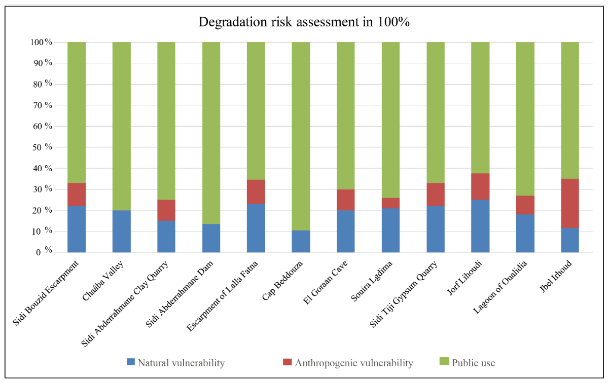
| Term | Definition |
|---|---|
| Natural vulnerability | The degree to which a geosite is susceptible to damage or destruction caused by natural processes that did not contribute to its formation. |
| Anthropogenic vulnerability | The degree to which a geosite is prone to damage or destruction resulting from human activities motivated by its economic value, including mining, quarrying, and fossil collecting. |
| Public use | The degree of a geosite’s exposure to damage resulting from its location and its current or potential use, including pressures such as vandalism, uncontrolled access, and lack of physical protection measures. |
| Fragility | The degree to which a geosite is susceptible to damage from natural processes related to its formation and inherently associated with its geological characteristics. |
| Criteria | Parameters | Indicators | Points |
|---|---|---|---|
| Natural Vulnerability | Active processes | No active processes affect the geosite. | 0 |
| A single active process affects the geosite episodically. | 1 | ||
| A single active process affects the geosite continuously or seasonally. | 2 | ||
| Two or more active processes affect the geosite. | 3 | ||
| Proximity | No potential degradation processes are present. | 0 | |
| One potential active process occurs near the geosite. | 1 | ||
| Two potential active processes occur in proximity to the geosite. | 2 | ||
| More than two potential active processes occur in proximity to the geosite. | 3 | ||
| Anthropogenic Vulnerability | Economic interest | No geological elements of economic value | 0 |
| The geosite contains one geological element of economic value | 1 | ||
| The geosite contains two geological elements of economic value | 2 | ||
| The geosite contains more than two geological elements of economic value | 3 | ||
| Private interest | No geological elements of private interest | 0 | |
| The geosite has one geological element of private interest | 1 | ||
| The geosite has two geological elements of private interest | 2 | ||
| The geosite has more than two geological elements of private interest | 3 | ||
| Public Use | Legal protection | The geosite is protected for its geological heritage | 0 |
| The geosite lies within a protected natural area | 1 | ||
| The geosite lies within an area protected for other values (historical, cultural, etc.) | 2 | ||
| The geosite is not located in a protected area | 3 | ||
| Human proximity | The geosite is located within 100 m of a potential degradation activity | 3 | |
| The geosite is located within 500 m of a potential degradation activity | 2 | ||
| The geosite is located within 1 km of a potential degradation activity | 1 | ||
| The geosite is located more than 1 km from a potential degradation activity | 0 | ||
| Accessibility | The geosite is within 100 m of a paved road and a bus parking area | 3 | |
| The geosite is within 100 m of a paved road | 2 | ||
| The geosite is within 100 m of a gravel road or 100–500 m from a paved road | 1 | ||
| The geosite is more than 100 m from a gravel road or more than 500 m from a paved road/has no direct access | 0 | ||
| Density of population | The geosite is in a municipality with fewer than 100 inhabitants/km2 | 0 | |
| The geosite is in a municipality with 100–250 inhabitants/km2 | 1 | ||
| The geosite is in a municipality with 250–1000 inhabitants/km2 | 2 | ||
| The geosite is in a municipality with more than 1000 inhabitants/km2 | 3 | ||
| Physical protection | The geosite has no protection | 3 | |
| The geosite has tourist facilities but no physical protection of geoheritage | 2 | ||
| The geosite has physical protection but no tourist facilities | 1 | ||
| The geosite has both physical protection of geoheritage and tourist facilities | 0 | ||
| Degrading use | No degradation from public use | 0 | |
| One element showing degradation | 1 | ||
| Two elements showing degradation | 2 | ||
| More than two elements showing degradation | 3 | ||
| Control of access | No control at all | 3 | |
| The geosite is monitored using one control method | 2 | ||
| The geosite is monitored using two control methods | 1 | ||
| The geosite is monitored using more than two control methods | 0 |
| Criteria | Partial Score | Total Score | Total Score on Degradation Risk | Risk Level |
|---|---|---|---|---|
| Natural Vulnerability | 0–6 | 0–33 | 0–7 | low |
| Anthropogenic Vulnerability | 0–6 | >7 ≤ 15 | medium | |
| >15 ≤ 25 | high | |||
| Public Use | 0–21 | >25 | very high |
| Geosite | Natural Vulnerability | Anthropogenic Vulnerability | Public Use | Total Degradation Risk | |||||||||||
|---|---|---|---|---|---|---|---|---|---|---|---|---|---|---|---|
| Active Processes | Proximity | Total | Economic Interest | Illegal Collecting | Total | Legal Protection | Human Proximity | Accessibility | Population Density | Physical Protection | Degradation Use | Control of Access | Total | ||
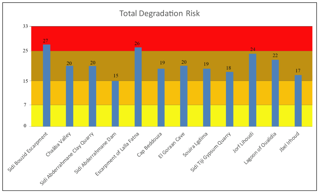
| Sidi Bouzid Escarpment | 3 | 3 | 6 | 0 | 3 | 3 | 3 | 3 | 3 | 1 | 2 | 3 | 3 | 18 | 27 |
| Chaâba Valley | 2 | 2 | 4 | 0 | 0 | 0 | 2 | 3 | 3 | 1 | 2 | 2 | 3 | 16 | 20 |
| Sidi Abderrahmane Clay Quarry | 2 | 1 | 3 | 1 | 1 | 2 | 3 | 2 | 2 | 1 | 2 | 2 | 3 | 15 | 20 |
| Sidi Abderrahmane Dam | 1 | 1 | 2 | 0 | 0 | 0 | 3 | 2 | 2 | 1 | 2 | 2 | 1 | 13 | 15 |
| Escarpment of Lalla Fatna | 3 | 3 | 6 | 0 | 3 | 3 | 3 | 2 | 3 | 0 | 3 | 3 | 3 | 17 | 26 |
| Cap Beddouza | 3 | 3 | 2 | 0 | 0 | 0 | 3 | 2 | 3 | 1 | 2 | 3 | 3 | 17 | 19 |
| El Goraan Cave | 2 | 2 | 4 | 0 | 2 | 2 | 3 | 2 | 0 | 1 | 3 | 2 | 3 | 14 | 20 |
| Souira Lgdima | 2 | 2 | 4 | 1 | 0 | 1 | 2 | 2 | 3 | 1 | 2 | 3 | 3 | 16 | 19 |
| Sidi Tiji Gypsum Quarry | 2 | 2 | 4 | 1 | 1 | 2 | 3 | 2 | 1 | 0 | 3 | 2 | 1 | 12 | 18 |
| Jorf Lihoudi | 3 | 3 | 6 | 0 | 3 | 3 | 3 | 2 | 1 | 0 | 3 | 3 | 3 | 15 | 24 |
| Lagoon of Oualidia | 2 | 2 | 4 | 1 | 1 | 2 | 1 | 3 | 3 | 1 | 2 | 3 | 3 | 16 | 22 |
| Jbel Irhoud | 1 | 1 | 2 | 1 | 3 | 4 | 2 | 2 | 1 | 0 | 3 | 2 | 1 | 11 | 17 |
Disclaimer/Publisher’s Note: The statements, opinions and data contained in all publications are solely those of the individual author(s) and contributor(s) and not of MDPI and/or the editor(s). MDPI and/or the editor(s) disclaim responsibility for any injury to people or property resulting from any ideas, methods, instructions or products referred to in the content. |
© 2026 by the authors. Licensee MDPI, Basel, Switzerland. This article is an open access article distributed under the terms and conditions of the Creative Commons Attribution (CC BY) license.
Share and Cite
El Hamidy, M.; Németh, K.; Omar, O. Assessing Degradation Risk of Geosites in the Safi Province (Marrakesh–Safi Region, Morocco). Sustainability 2026, 18, 4934. https://doi.org/10.3390/su18104934
El Hamidy M, Németh K, Omar O. Assessing Degradation Risk of Geosites in the Safi Province (Marrakesh–Safi Region, Morocco). Sustainability. 2026; 18(10):4934. https://doi.org/10.3390/su18104934
Chicago/Turabian StyleEl Hamidy, Mustapha, Károly Németh, and Outaaoui Omar. 2026. "Assessing Degradation Risk of Geosites in the Safi Province (Marrakesh–Safi Region, Morocco)" Sustainability 18, no. 10: 4934. https://doi.org/10.3390/su18104934
APA StyleEl Hamidy, M., Németh, K., & Omar, O. (2026). Assessing Degradation Risk of Geosites in the Safi Province (Marrakesh–Safi Region, Morocco). Sustainability, 18(10), 4934. https://doi.org/10.3390/su18104934