Article

Global Pursuits of Sustainable Transport and Their Challenges in the Context of a Historic Town: The Case of Park-and-Ride Development in Stary Sącz, Poland

by
Anna Szewczyk-Świątek
1,* and
Wojciech Świątek
2
1
Faculty of Civil Engineering and Resource Management, AGH University of Krakow, Al. Mickiewicza 30, 30-059 Krakow, Poland
2
Faculty of Architecture, Cracow University of Technology, Ul. Podchorążych 1, 30-084 Krakow, Poland
*
Author to whom correspondence should be addressed.
Sustainability 2026, 18(1), 393; https://doi.org/10.3390/su18010393
Submission received: 1 December 2025 / Revised: 25 December 2025 / Accepted: 27 December 2025 / Published: 30 December 2025
(This article belongs to the Special Issue Sustainability and Innovation in Engineering Education and Management)

Abstract

The effort to reduce the intensity of car traffic in city centres is among the core objectives of sustainable development. One important means of achieving this aim is the creation of Park-and-Ride facilities. This article examines the challenges encountered during the planning and construction of a Park-and-Ride designed to ease the transport burden of a larger city, yet situated on the edge of a small historic town in Poland. Using a research-through-design method, the study identifies the project’s challenges. The article highlights the overlooked issue of locating Park-and-Ride schemes within sensitive contexts. The accompanying interventions enabled the realisation of an undertaking, originally conceived as a strictly engineering investment fulfilling global policy objectives, but ultimately adapted to manage local priorities. The pursuit of sustainable transport development thus became an opportunity to foreground the dual role of transport spaces: both as organisers of movement and as educators in conveying cultural meaning. The project serves as an example of how local problems may be addressed through investments framed as advancing global political goals. The Park-and-Ride in Stary Sącz also provides material evidence of the significance of decisions made by local authorities to resolve local challenges while contributing to global goals.

1. Introduction

The 2030 Agenda for Sustainable Development was adopted by the United Nations ten years ago, and Poland currently ranks within the top 10 of the 193 countries committed to its implementation. Over the past decade, Poland has risen by nearly thirty places in global sustainable development rankings [1] (p. 4). Among the factors contributing to this advancement are investments in the transport sector [2]. This article examines the design and implementation of a Park-and-Ride hub combined with a cultural route—a local project made possible by aligning it with wider sustainable development policies. Indicators used to monitor progress towards these policies underscore the importance of increasing the number of low-emission public transport vehicles [1] (p. 15), which the scheme under analysis was intended to achieve. Its first stage was financed through the programme titled Expansion of the Low-Emission Transport System [3]. The pursuit of sustainable mobility constitutes a global policy objective whose translation into local governance introduces social, economic and spatial challenges. In this article, the construction of the Park-and-Ride facility is examined as a case through which to consider how global policy frameworks shape local decision-making. It is argued that even ostensibly straightforward engineering projects embody the interplay between global and local imaginaries of sustainable development. Understanding built structures as material manifestations of the relationship between global and local authority provides insights into how power is spatially exercised. The paper highlights the challenges local authorities face as they attempt to implement global political objectives and the strategies they adopt when such interventions are likely to be questioned by residents.
The study is situated in Stary Sącz, a town committed to sustainable development and recognised in 2021 as the most sustainable Polish city with fewer than 100,000 inhabitants (Eco-Miasto ranking) [4]. Stary Sącz seeks to reconcile economic development and a growing tourism sector with the global imperatives of the 2030 Agenda. This case illustrates the difficulties encountered when global policy targets are implemented in smaller settlements. It underscores the importance of identifying current local needs as a precondition for effective action. The case study focuses on the process of preparing, designing and constructing the Park-and-Ride facility, enabling an examination of architectural and urban considerations relevant to Park-and-Ride development in the immediate vicinity of a small historic town. The project demonstrates the importance of material spatial interventions in translating global policy frameworks into local expectations and into a pace of change that residents find acceptable. The Park-and-Ride in Stary Sącz has received several professional awards, including First Prize in the “Public Space” category of the prestigious 2024 Stanisław Witkiewicz Małopolska Award. The jury described the project as “the best contemporary architectural realisation supporting the protection and shaping of the cultural landscape of Małopolska”, highlighting the significance of local spatial governance and architectural–urban design in implementing global sustainable development objectives.

2. Basics for Park-and-Ride Design

2.1. Park-and-Ride as an Element of Global Sustainable Development Policy

Reducing the negative impact of transport on cities remains one of the central goals of sustainable development [5]. Although awareness of the need to limit reliance on individual motorised transport is widespread, the number of private cars in the European Union continues to increase. Over the past decade, the EU’s car fleet has grown steadily, reaching almost 260 million registered vehicles [6]. Researchers and policymakers increasingly emphasise the importance of planning intermodal transport nodes—Park-and-Ride facilities—that integrate effectively with the urban environment and enable the combination of private car use and public transport within a single journey (e.g., [7]). While existing guidelines specify functional requirements, they do not dictate whether Park-and-Ride facilities should be in the form of surface-level car parks or multi-storey structures. In general terms, Park-and-Ride facilities comprise clusters of parking spaces located in peripheral urban areas, connected directly to public transport networks, allowing travellers to continue their journey without a car. The most frequently cited motivations for constructing Park-and-Ride infrastructure include reducing traffic volumes on main routes leading into city centres (e.g., [8]) and cutting emissions—particularly when the onward journey involves low-emission public transport (e.g., [9]). Scholars increasingly explore correlations between travel time, waiting time, emissions and user satisfaction [10], showing that these parameters entail trade-offs. For example, travel time tends to correlate positively with emissions, while waiting time tends to negatively correlate with travel time, and the relationship with emissions varies depending on context. Some studies indicate that Park-and-Ride schemes reduce the distance travelled by private vehicles, while extending public transport routes [11]—though the overall environmental and mobility benefits remain positive. Concerns also exist about the potential for induced car traffic resulting from the provision of new parking capacity, which might, in some cases, discourage a shift to alternative modes such as cycling. Another issue is the risk of dispersed development patterns emerging around new infrastructure, as Park-and-Ride sites may stimulate the urbanisation of surrounding areas [12].
Despite these reservations, Park-and-Ride facilities remain widely recognised as contributing to sustainable development goals and are frequently supported by European that promote programmes promoting low-emission transport systems. While external financial support often incentivises their construction, long-term operation requires ongoing funding from operators and users. Studies highlight the importance of modelling parking fees so that the total cost of a combined journey remains attractive (e.g., [13]). At the same time, Park-and-Ride facilities should not be expected to generate revenue [14]. Low or zero parking charges are considered as crucial to achieving high utilisation [15]. In other words, achieving sustainable development objectives depends on keeping user costs low, as full-cost pricing tends to deter travellers and undermines the fundamental aim: reducing individual car traffic while encouraging the use of low-emission public transport.

2.2. Park-and-Ride as an Element of Local Policy

Design recommendations for Park-and-Ride facilities commonly emphasise the need to provide conflict-free circulation for pedestrians, cyclists, cars and public transport vehicles, together with kiss-and-ride areas and integration with the spatial and social context to foster public acceptance (e.g., [16]). Among the key planning considerations, the choice of location receives particular attention. The required number of parking spaces is often estimated through comparative studies of similar sites or through assessments of local attractiveness, the characteristics of surrounding areas and travel time to the target destination (e.g., [17]). Distance from the serviced city centre is also a relevant factor. Four types of Park-and-Ride are typically distinguished: local, peripheral (at the city boundary), suburban (18–80 km from the centre) and remote (up to 160 km away) [18]. Beyond the factors already noted—location attractiveness and travel time—scholars also highlight the importance of public transport accessibility, multimodal connections, facility size, intelligent occupancy information systems, neighbourhood change and the need to monitor social trends [19]. In European cities, available sites are relatively limited, and integrating new parking facilities with existing public transport networks often requires upgrading or extending existing infrastructure [7]. Given spatial constraints and the questionable economic return on investment, the decision to construct a Park-and-Ride facility is often a political one—sacrificing valuable land that could be used more profitably to yield environmental or mobility benefits elsewhere. This decision is complicated by the fact that such facilities may reduce the property value of adjacent plots (e.g., [20]).
Donald Shoup’s influential work The High Cost of Free Parking [21] argues that the quantity and management of parking are political issues that merit far greater attention from local governments. Following Shoup, Eran Ben-Joseph [22] notes that large parking areas are often used only intermittently. He argues that local planning regulations should specify not only required parking numbers but also provide design guidance to ensure higher quality environments. Despite occupying substantial areas, parking facilities are often marginal in public debate. They are also frequently used—formally or informally—for functions other than parking. They may (and arguably should) host community meetings, markets, cultural events, film screenings or performances [23]. While the principal users of Park-and-Ride facilities are generally assumed to be commuters travelling to work or shopping (e.g., [7]), tourists may also represent a significant user group in certain locations [24]. Studies further show that these spaces attract users outside peak hours, especially groups seeking areas with low levels of natural surveillance and relatively small numbers of long-term users [25]. Concerns related to CPTED (Crime Prevention Through Environmental Design) are widely discussed in the literature, emphasising the importance of urban design, land-use planning, supplementary activities, landscape treatments, lighting, signage, and similar measures (e.g., [26]). Surprisingly, the same spatial qualities deemed problematic from a safety perspective are often valued by teenagers and young adults [27]. Intermodal transport sites may attract younger adolescents who do not yet hold a driving license [28]. A lack of design guidance addressing their presence, along with the absence of planning for temporary or alternative uses, can lead to these spaces being overlooked as potentially significant elements of the urban realm.
The first Park-and-Ride facilities, built in the 1920s in the United States, were associated with railway lines, the parking fee included a return train ticket [29]. Their purpose was to encourage the use of collective rail transport. In contemporary Poland, similar facilities are commonly located near railway stations, tram and bus termini and metro stops. However, transport operators no longer build or maintain such infrastructure. Responsibility has shifted to municipal road authorities and other local government bodies (e.g., [30]). While road construction and maintenance remain broadly accepted municipal tasks, building parking facilities is increasingly subject to public opposition. Residents often argue for relocating proposed sites and replacing them with green spaces (e.g., [31]). In this context, constructing and maintaining a non-profitable, intermittently used facility intended to serve a neighbouring city—as part of global sustainable development initiatives—does not always secure political support. At the same time, it is not uncommon in compact European urban settings for Park-and-Ride hubs to be located within one municipality but primarily serve another. Local authorities sometimes proceed with such investments despite anticipating their unpopularity. The Park-and-Ride facility in Stary Sącz provides a valuable opportunity to examine the challenges and objectives associated with such politically layered projects.

3. Materials and Methods

3.1. Case Study

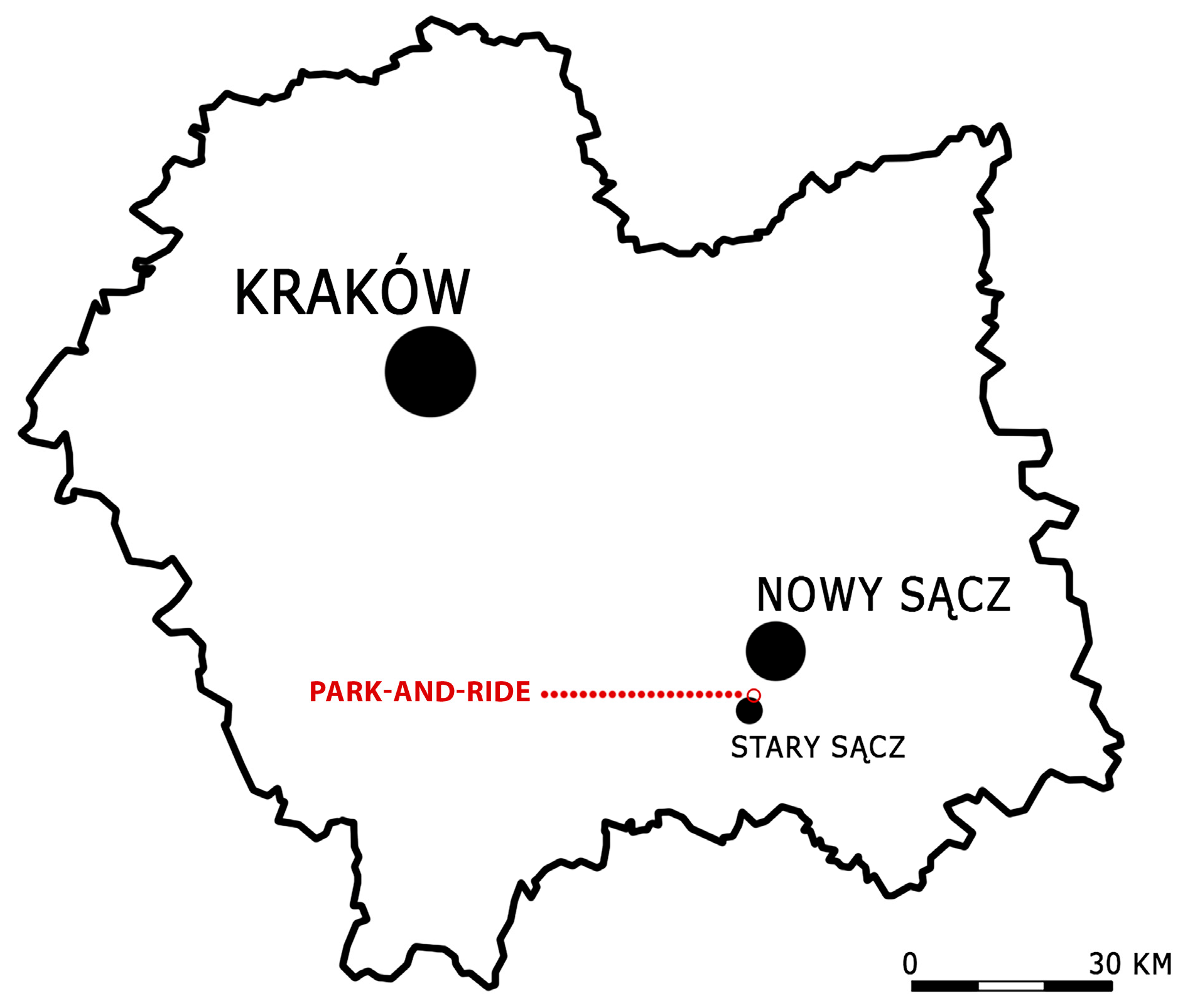
The Park-and-Ride facility analysed in this article is located in southern Poland, in the Małopolska Voivodeship, within Nowy Sącz County, in the municipality of Stary Sącz, adjacent to the larger city of Nowy Sącz, which holds the status of a city with county rights (Figure 1). The distance from the Park-and-Ride to the centre of Nowy Sącz—the city it is intended to relieve—is approximately 9.5 km. In contrast, its distance from the centre of Stary Sącz is roughly 0.5 km. The road between Nowy Sącz and Stary Sącz is a national road (symbol DK87). The average daily annual traffic of motor vehicles on it is over 23.000 [32]. This is almost twice the national average for national roads [33]. Following the project’s implementation, five suburban bus lines connect the Park-and-Ride with Nowy Sącz and Stary Sącz.

3.1.1. Nowy Sącz

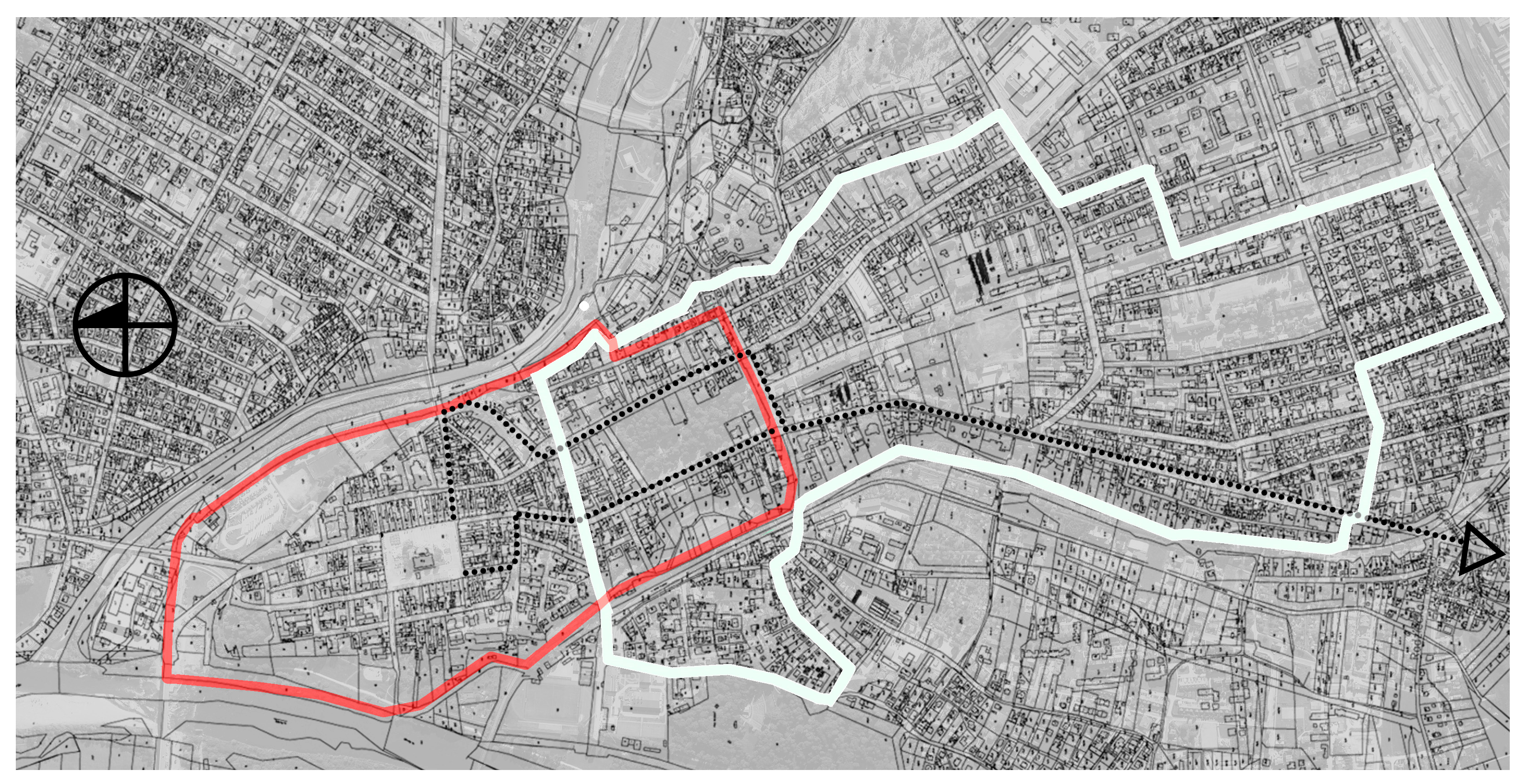
Nowy Sącz is the third-largest city in the Małopolska region, with a population of 79.8 thousand. It serves as an important economic (over 10,000 registered enterprises), commercial and cultural centre for the region, yet faces risks of marginalisation partly due to inadequacies in its connections with surrounding municipalities [34]. It functions as the principal destination for travellers from neighbouring towns. A diagnostic study of the Sącz Functional Area [35] identifies underdeveloped intermunicipal public transport network, which contributes to increased emissions and noise levels and reinforces a preference for private cars (53% of respondents declare choosing individual motorised transport). The urban layout of Nowy Sącz’s historic centre—based on its preserved medieval plan (the city was founded in 1292)—is listed in the national register of monuments. It is characterised by compact, modular perimeter-block development, narrow street interiors and an acute shortage of space suitable for parking without compromising heritage values [36]. The areas of the city centre that developed beyond the medieval core in the 19th century form a coherent continuation of the older layout and face similar mobility-related pressures (Figure 2).

3.1.2. Stary Sącz

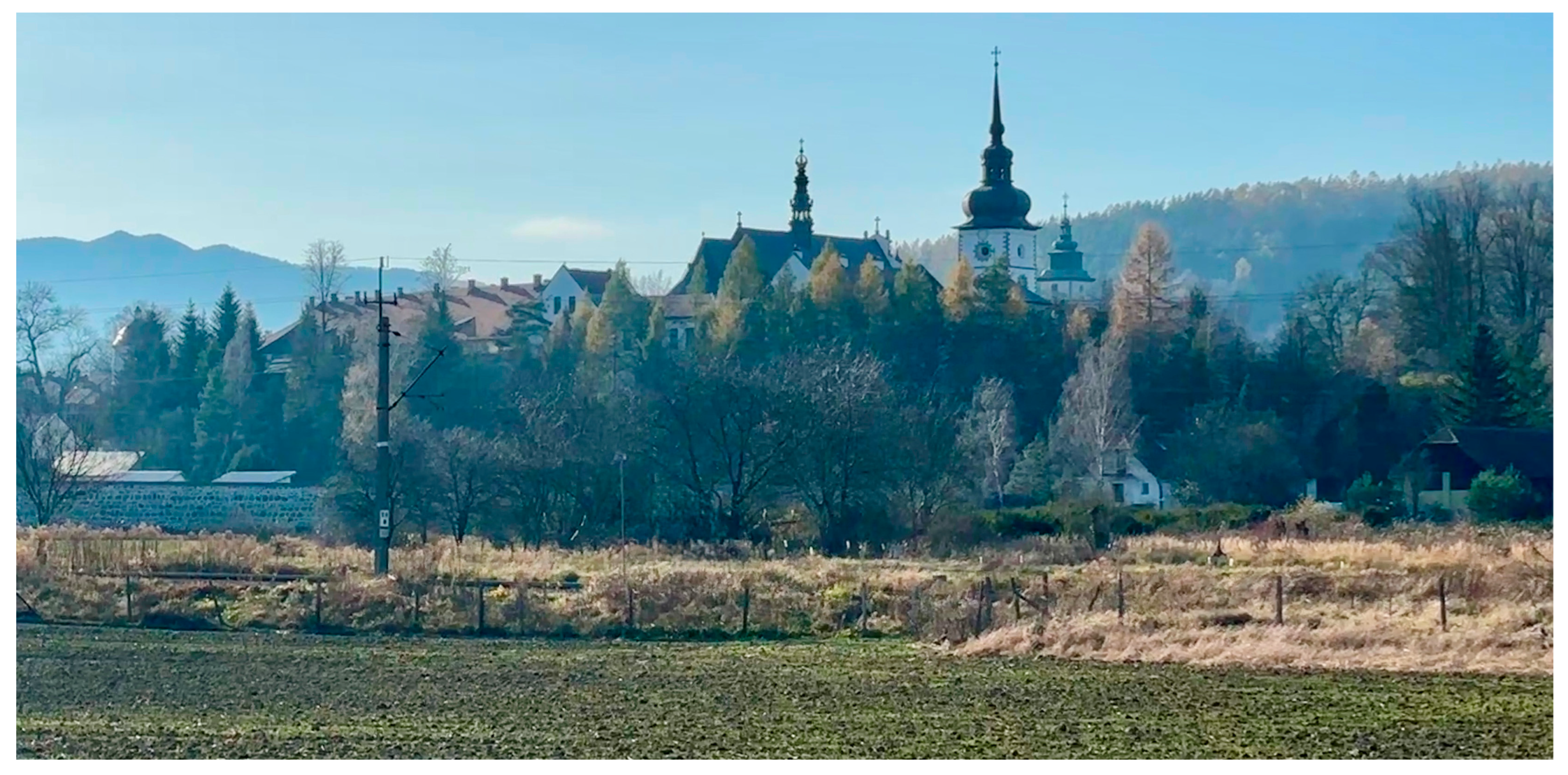
Stary Sącz is among the oldest towns in Poland, with the earliest written reference dating back to 1224. It is situated along a historic trade route linking Hungary and Kraków. The town retains a well-preserved medieval layout shaped by its association with the convent of the Poor Clares, founded in 1280 (the burial place of, among others, St Kinga and Jadwiga Bolesławówna, Queen of Poland between 1320 and 1333; Figure 3) [37]. The town holds the status of Pomnik Historii (Historic Monument)—a designation granted by the President of Poland, upon recommendation of the Minister of Culture and National Heritage, to sites of outstanding cultural significance [38].
Despite its importance as a tourist destination, Stary Sącz has limited accommodation capacity and therefore functions largely as a site for one-day visits. Most visitors arrive by private car. The narrow historic streets, open to vehicular traffic, are accompanied by pavements often less than one metre wide, frequently located on a single side of the street and obstructed by numerous architectural barriers. Parking spaces are scarce; consequently, part of the market square—the town’s most representative public space—has been allocated to vehicular parking (Figure 4).

3.1.3. Park-and-Ride for Nowy Sącz Located in Stary Sącz

The core part of the investment was undertaken within the project Expansion of the Low-Emission Public Transport System of the Sącz Agglomeration, co-financed by the European Union through the Regional Operational Programme of the Małopolska Voivodeship 2014–2020. It was officially opened in January 2020. The accompanying works, essential to ensuring the facility’s full functionality, were completed in November 2023. Preparatory and research activities, however, date back to 2015. The Park-and-Ride facility comprises 130 parking spaces for cars (including six adapted for persons with disabilities) and four bus bays. Additional components include a passenger waiting room, a bus stop with a lay-by, a bicycle shelter, a recreational shelter and street furniture. In accordance with the funding framework, the project aims to reduce transport pressure on Nowy Sącz by providing parking spaces for commuters in Stary Sącz. The main stakeholder in the project was the City of Nowy Sącz (implementing the aforementioned EU project), and the partners were the City and Municipality of Stary Sącz (public authority regulating local law, owner of the land, developer of Park-and-Ride) and Nowy Sącz Municipal Transport Company (transport operator responsible for implementing the project’s results in the area of fleet management, public transport routes and passenger information). In addition, the Office for the Protection of Monuments (guarding the cultural and natural values of the town of Stary Sącz) should be considered an important party to the proceedings. Commuters, potential users and owners of local businesses were only informed about the project through local internet portals and social media, and their comments were tracked by public authorities and designers.
Although the selected example is not the only type of development relevant to understanding how global policy frameworks are translated into local interventions, it may be considered a paradigmatic case—one that enables the identification of patterns and relationships characteristic of broader processes. Giorgio Agamben [39] argues that the construction of paradigms is a principal aim of case study research, as the examination of a single case makes it possible to identify features that illuminate a wider class of phenomena. In this study, the location, form and function of the project are analysed to explore how material interventions are employed in the exercise of power—both global and local. This is not to suggest that the design characteristics of the project are reducible to their instrumental political use; rather, the claim is that this threat is significant and aligns with a still relatively limited body of research examining the implementation of global sustainable development directives in smaller urban centres (e.g., [40]).

3.2. Methods

The research was conducted using the research-through-design method, widely recognised in the fields of art and design [41]. Developing the project and being directly involved in discussions at various stages of work provides access to a broader range of information than would be available through the study of a completed building. Research-through-design requires the active participation of the researcher in the examined process, and many insights collected in this manner would remain inaccessible through other methodological approaches. It should nonetheless be acknowledged that, despite efforts to maintain objectivity, the awareness among stakeholders that the researchers were also the designers may have influenced some decisions.
The study was carried out across four phases: pre-design, design, construction and post-completion. Each phase involved different research methods and techniques appropriate to the stage.

3.2.1. Research Methods in the Pre-Design Phase

In the initial phase, unstructured interviews were conducted with decision-makers, representatives of the Stary Sącz local government and municipal officials, who discussed issues they considered important in the context of sustainable transport development. These interviews made it possible to determine the future terms and conditions for signing a contract for project work. The information gained was analysed using interpretative methods. Themes that emerged constituted the investor’s guidelines for the agreement and included the problem of traffic congestion in Stary Sącz, the challenges of obtaining approval from heritage authorities for constructing a parking facility and the opportunities created by sustainable development funding programmes. The interpretation of these interviews provided a basis for examining the relationships among these issues.
Subsequently, a typological analysis of transport spaces was performed (following the studies of Rob Krier [42]), focusing on the sections of streets and squares within the historic monument area and the surroundings of the site owned by the investor. Using Aldo Rossi’s method of urban morphological analysis [43] and Kevin Lynch’s approach to sensory urban perception [44], the most important historical and natural elements of the protected urban structure of Stary Sącz and its foregrounds were identified.
These analyses enabled an assessment of the protected landscape resources and formulation of guidelines for the panorama of Stary Sącz as seen from the road linking Nowy Sącz and Stary Sącz. The panorama study was based on Janusz Bogdanowski’s JARK-WAK method [45].
The comparison of themes emerging from interviews, urban analyses and landscape analyses allowed for the formulation of initial design assumptions for a facility compatible with global sustainable development objectives. These assumptions were then confronted with the expectations of the relevant heritage authorities.

3.2.2. Design Phase—Research-Through-Design in Practice

The next phase was conducted in parallel with the creation of the architectural design, commissioned to the architectural office 55Architekci (co-owned by the authors of this article) as a commercial project. The team simultaneously carried out research and worked on the Park-and-Ride design. Proposed solutions were discussed with the investor, municipal officials, heritage authorities and planners, enabling immediate verification, in line with the principles of research-through-design [41]. The project was presented to the public via local media, allowing residents to comment on the proposal. Visualisations and short descriptions were published regularly during the design and construction processes on social media, local information platforms and the official website of the Stary Sącz municipality. Comments were analysed using interpretative methods (122 opinions were reviewed: 80 from November–December 2015 and 30 from October 2017). Since only online comments were analysed and the sample was small, conclusions from this phase should be regarded as preliminary, signalling tendencies and requiring further investigation in other locations. Still, following Jeremy Till’s theory of participation as a negotiation of hope [46], these comments were treated as expressions of residents’ engagement with the implementation of sustainable development goals. They were categorised into thematic groups: aspirations related to sustainability and assessments of the project’s functionality.

3.2.3. Research-Through-Construction

Architects are legally required to participate in the construction process—to attend technical meetings, address concerns and provide solutions to emerging issues. Consequently, the building stage was examined through controlled, overt participant observation [47]. Some observations were formally recorded in the construction logbook; others were archived as notes by 55Architekci.
As mentioned earlier, the project was built in two stages: the main facility was completed between 2018 and 2020, while its connections to the town were constructed only in 2023. The interval between the stages involved conversations with local authorities and officials, again conducted as unstructured interviews, which were analysed interpretatively. The same method was used for online comments appearing on local online information platforms.

3.2.4. Post-Completion Observations

Based on quantitative data systematically collected by the Stary Sącz municipal office since the facility’s opening, an assessment of its operational performance was conducted.
Additionally, publicly available opinions, reviews and comments about the completed Park-and-Ride posted on Google over the past two years (i.e., since its opening) were analysed and categorised. Special attention was given to the municipality’s promotional activities (and their direction) and to the ways in which residents and visitors use the facility. Given the limited scope of this part of the research and the number of entries (approximately 200), the findings should be regarded as indicative rather than definitive; nonetheless, they highlight opportunities and risks associated with this and similar investments.

4. Results—Challenges of Fitting Global Goals into a Local Context

Implementing global sustainable development objectives in the field of transport introduces the need for investments that may be viewed by local users as unnecessary. New spaces intended for individual motorised transport are presented as supporting the development of public transport, which is expected to alleviate congestion and address problems faced by drivers. However, these are not bottom-up initiatives, and their realisation at the local level requires lobbying and promotional efforts.
The authors’ initial conversations with the authorities of Stary Sącz (in 2015) revealed that residents were unlikely to express enthusiasm for constructing a Park-and-Ride facility serving to relieve traffic in Nowy Sącz when located within their own municipality. Their mobility problems relate primarily to the scarcity of parking spaces within Stary Sącz itself, rather than to commuting to the neighbouring city. At the same time, municipal representatives disclosed that plans to build a parking facility to ease traffic in Stary Sącz had been under consideration for years, and that the possibility of securing external funding would create favourable conditions for their realisation. They also noted that earlier attempts to develop such a facility on land at the town’s edge had never progressed beyond initial heritage-authority consultations, raising doubts about the project’s feasibility due to its anticipated negative impact on designated historic monument’s landscape.
Facing this challenge, the design team set out to address two fundamental questions: How can a global objective be combined with local needs? How can resistance from residents and heritage authorities be mitigated when the project, though aligned with sustainable development goals, is perceived as unnecessary for Stary Sącz?

4.1. Pre-Design Phase

4.1.1. Urban Analyses

Knowledge of the available land parcel, the potential difficulties of obtaining heritage approval and the likely lack of public acceptance prompted the design team to begin with urban analyses aimed at identifying spatial resources and establishing initial design guidelines.
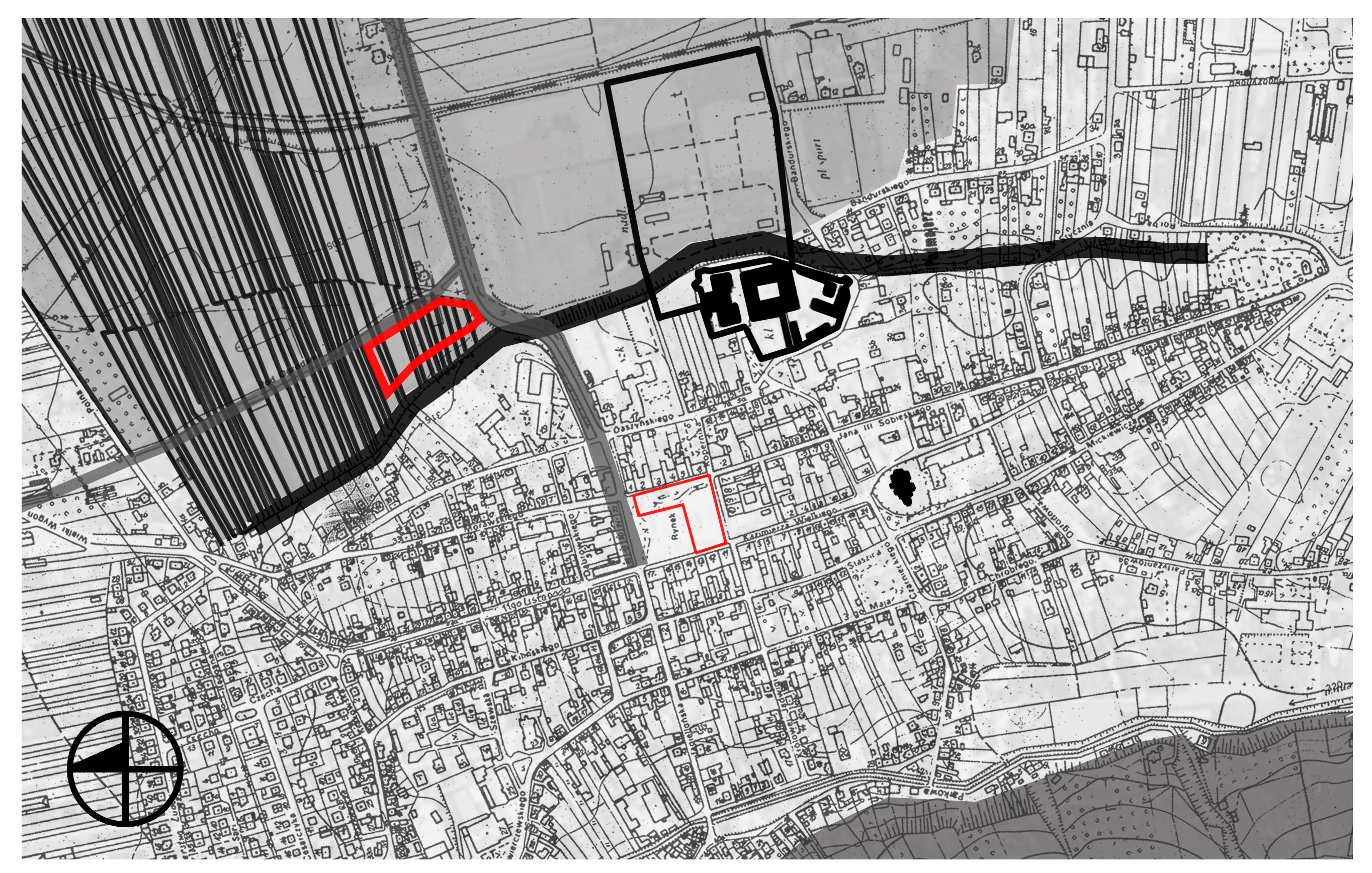
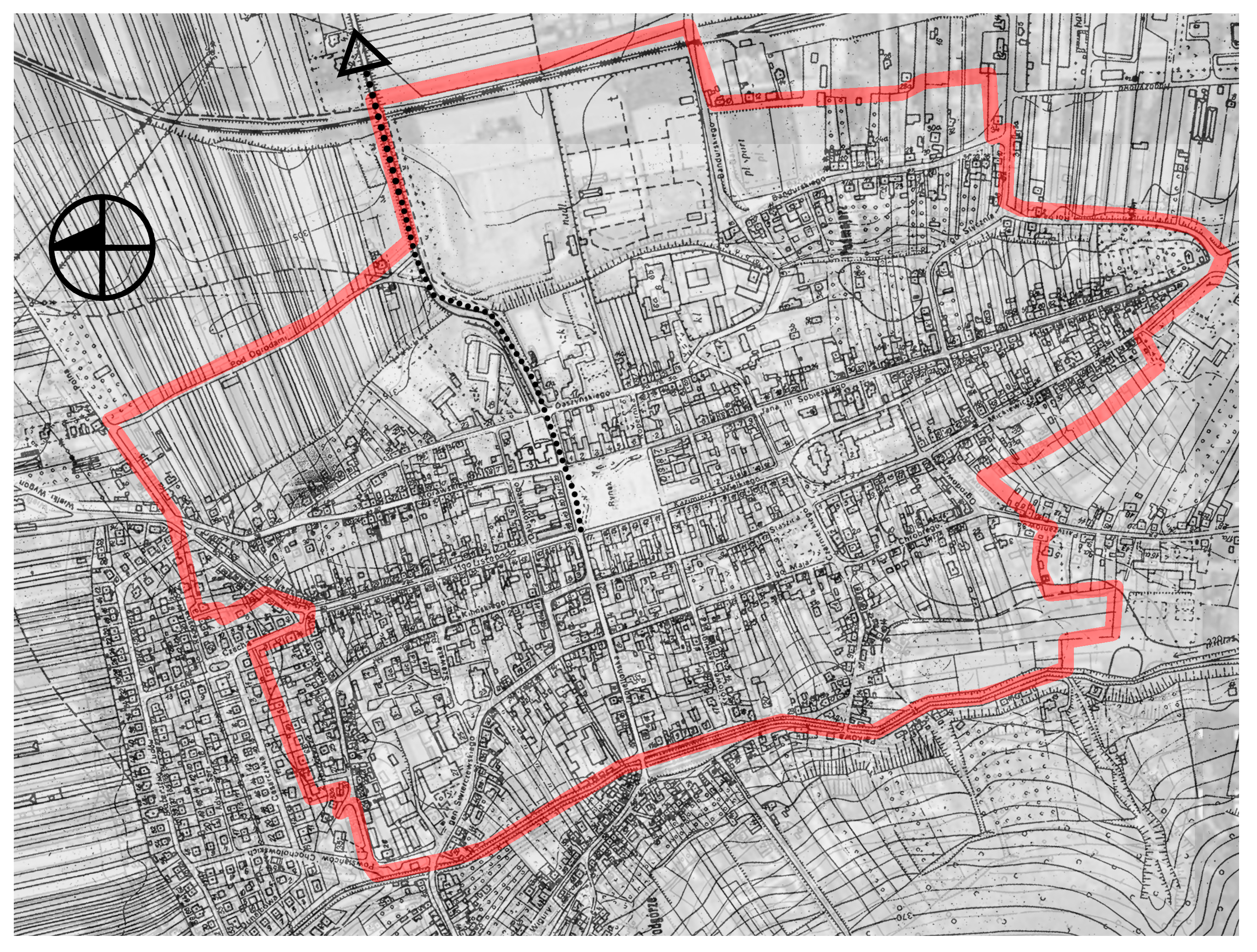
Morphological analysis indicates that the town has retained a concentric structure. Alongside the convent and the parish church, a reinforced medieval scarp constitutes a key element of this arrangement, defining the town’s boundary long before the grid layout still in use today was introduced. The road leading to Nowy Sącz cuts through this scarp and was established only in the 19th century [37] (Figure 5). Historically, convent gardens occupied the land below the scarp. However, reduced in size, their unfragmented form remains visible south of the road. These grounds have been protected from development for decades. By contrast, development was permitted north of the road, and in the 1970s a small bypass was constructed parallel to the scarp, terminating at a T-junction with the road connecting Stary Sącz and Nowy Sącz [48]. The land between the bypass and the scarp—owned by the municipality—was designated as the site for the Park-and-Ride facility.
A typological analysis shows that buildings located along the scarp have preserved their traditional forms: residential structures with steep gabled roofs, deep eaves forming arcades and layouts organised around central passage halls. Most are single-storey. Below the scarp, the former monastic gardens remain undeveloped due to heritage protection dating back to the 1950s [49]. North of the road, fields have a regular pattern, with boundaries aligned along east–west axes, echoing the proportions of medieval blocks (Figure 5). The proposed Park-and-Ride location lies on these undeveloped post-convent grounds.
Sensory-perception analysis identified key elements: landmarks (church and monastery towers), the path (the road to Nowy Sącz), nodes (the market square and the crossroads with the roadside shrine at the foot of the scarp), and districts (the forested Miejska Góra, the Old Town and the scenic foreground stretching 200 m from the railway line to the scarp). The scarp functions as both a pedestal and an edge. It is covered by trees, with more than 20 of them registered as natural monuments. Passing the scarp involves a ritualised transition through the town’s informal gate (Figure 5).
As previously noted, the rectangular street grid defines the town’s composition. Much of the market square is used for parking, and two public transport stops are located there. The road connecting Stary and Nowy Sącz runs along the northern edge of the square. Approaching the town, the road ascends gently from the Poprad valley, rising over the railway line and creating a viewpoint. Its curve enables drivers and pedestrians to negotiate the 7.5–8 metre height difference at the base of the historic urban tissue, leading toward the market square located approximately 5 metres above the scarp. Narrow pedestrian routes accompany this road, yet reaching the town centre on foot requires using stairs (Figure 5).
The analyses demonstrated that the scarp, the convent, the protected trees and the scenic foreground constitute the most critical morphological, typological and perceptual elements relevant to planning the project. It was noted that the proposed site lies within the town’s silhouette foreground. The presence of parking surfaces in the historic centre aesthetically competes with the low-rise traditional architecture that expresses the town’s identity. Additionally, the lack of barrier-free pedestrian connections between the proposed Park-and-Ride site and the town centre was identified as a significant deficiency.

4.1.2. View Analysis

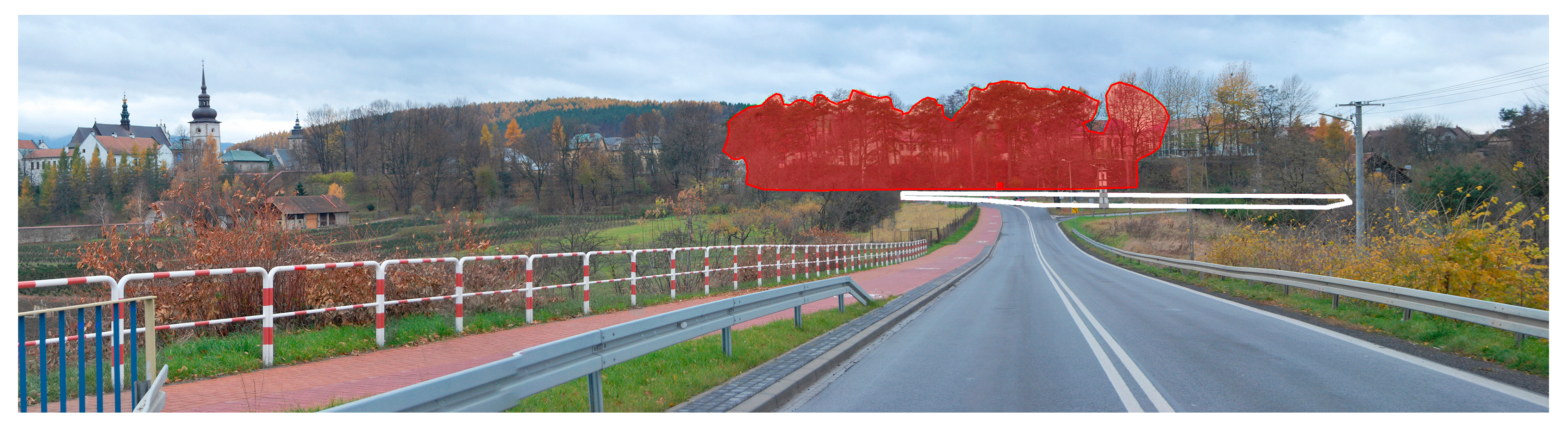
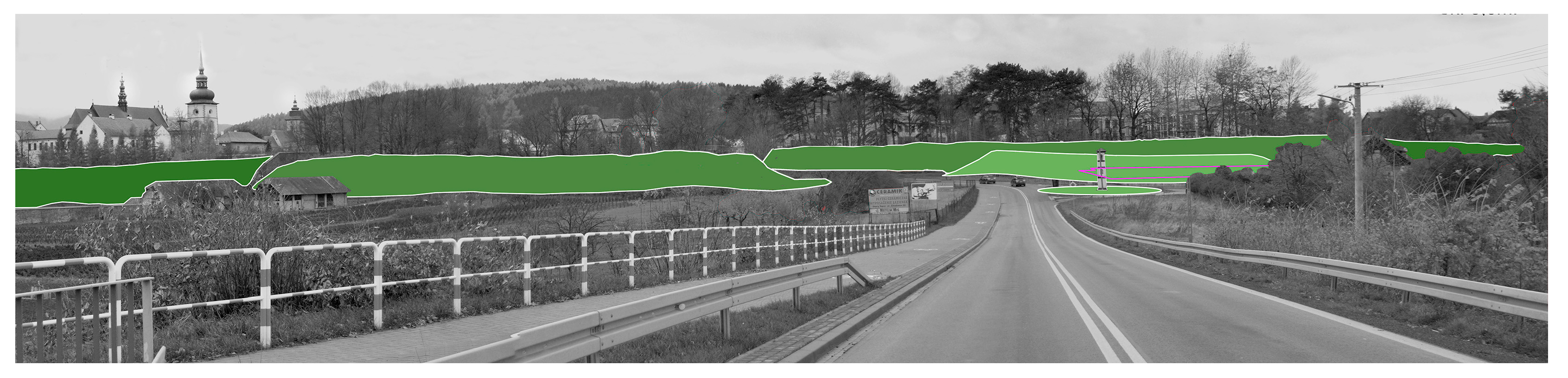
Identifying the most important viewpoint—the elevated section of the road above the railway line on the main approach from Nowy Sącz—enabled a detailed view analysis, which revealed the weaknesses of the available site (Figure 6). The parcel is highly exposed, situated adjacent to the scarp and monumental trees. Parked cars would visually compete with the convent in the landscape, and the roadside shrine would lose its role as a focal accent. It was therefore concluded that minimising the facility’s visibility should constitute a fundamental design strategy.

4.1.3. Challenges in the Pre-Design Phase

On-site inspections and visualisations of the proposed Park-and-Ride location confirmed the conclusions drawn from the urban analyses. In the local context, the major challenge lay in integrating the project—both visually and functionally—with the historic municipal landscape, which is protected as a monument. Two issues emerged as critical: the risk that the new development might visually obscure the historic scarp, and the absence of a barrier-free pedestrian connection between the proposed facility and the centre of Stary Sącz. The lack of such a connection represented a significant limitation that could reduce the usefulness of the Park-and-Ride for residents and visitors alike.
Despite these challenges, municipal authorities decided to pursue the project in support of sustainable transport objectives, fully aware that the investment might face resistance from heritage authorities and from the local community. Moreover, the decision was taken even though that the predicted travel time by public transport from the Park-and-Ride to the centre of Nowy Sącz would be longer than by car (40 min versus 20–40 min, estimated via google.pl/maps). Preparatory work was initiated without any guarantee of external funding [50]. The mere prospect of obtaining financial support encouraged local authorities to take on the task, which entailed extending public bus routes and constructing passenger-service facilities. In the longer term, proximity to the railway line was seen as a potential advantage, and the municipality resolved to lobby for establishment of a new railway stop in the vicinity.

4.2. Design Phase

4.2.1. Park-and-Ride Concept Within the Passive View Exposition

The design process began with an analysis of the facility’s impact within the passive view exposition. The selected viewpoint, located above the railway line crossing the Stary Sącz–Nowy Sącz road, represents the highest elevation along the route used by the vast majority of visitors arriving in the town. Regardless of the precise viewpoint, the road forms a linear axis from which every point along the proposed site remains visible; the future Park-and-Ride would therefore be exposed from all positions along the approach. The view analysis identified a four-layered panoramic structure composed of the foreground; the scarp functioning as a pedestal; the townscape (buildings and monumental trees); and the forested slopes of Miejska Góra, forming the background. The project site lies within the foreground, adjacent to the scarp. To avoid introducing an additional visual plane and to preserve the historic view, the design strategy adopted the scarp as a formal model, using its morphology to visually screen the new facility and to integrate it into the landscape. During this process, and due to safety concerns regarding traffic, the municipal authorities deemed it appropriate to modify the geometry of the adjacent intersection—replacing the existing T-junction with a roundabout. Based on geodetic data, the elevation of the historic scarp on which the town is situated ranges from 316.5 to 317.2 m a.s.l. The highest point of the passive viewpoint was measured at 312.1 m a.s.l. Consequently, the proposed screening embankment was designed to reach 312.5–314.5 m a.s.l., raising it approximately 5 metres above the parking level while remaining visibly lower than the historic scarp (Figure 7).

4.2.2. Concept for Mobility Connections and Their Integration with the Landscape

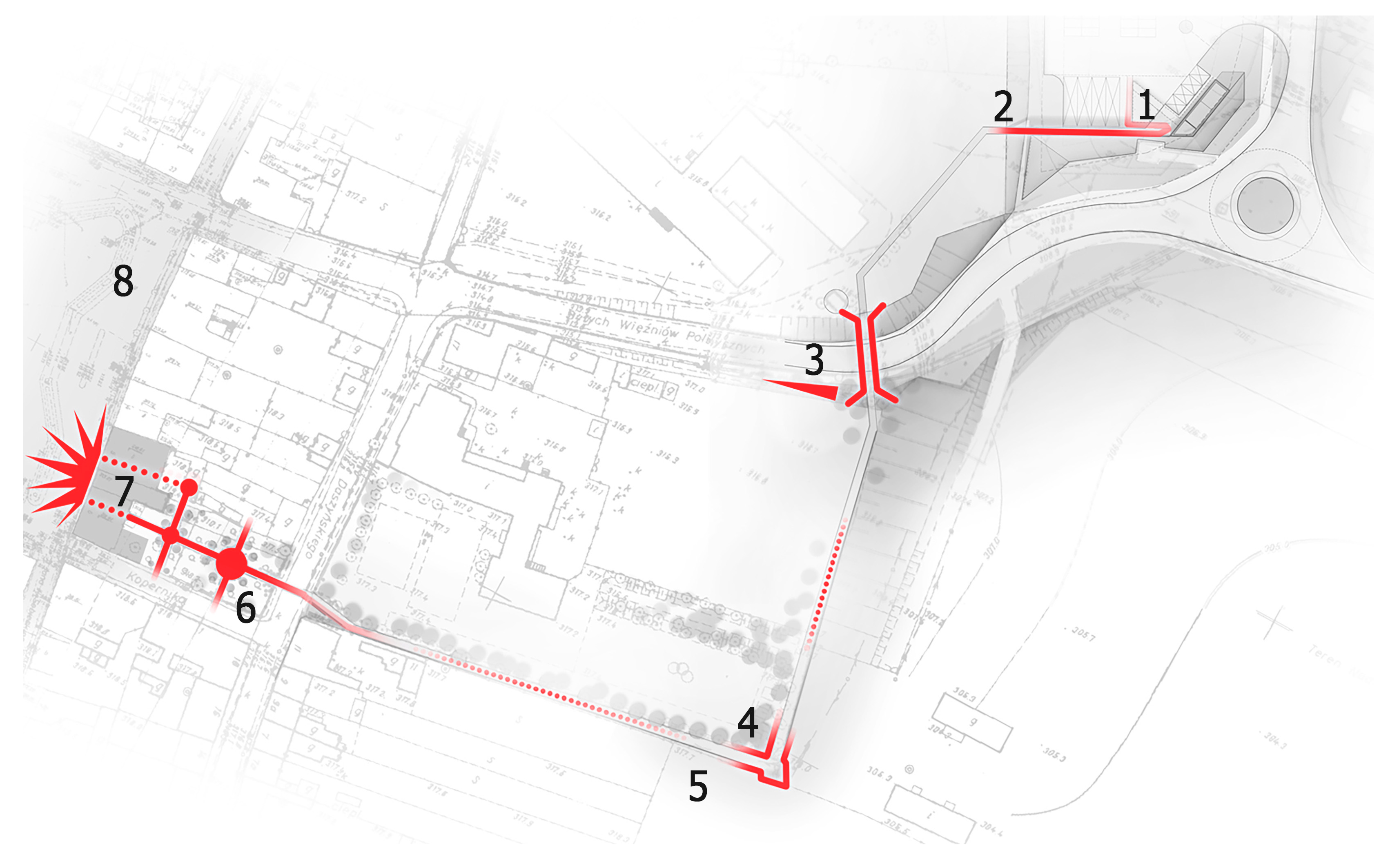
Addressing the question of how the Park-and-Ride investment would affect the protected landscape became central meeting the challenge of implementing sustainable transport goals. In this configuration, the parking facility could function as infrastructure facilitating public transport use for commuters travelling to the regional centre, Nowy Sącz. However, as noted earlier, the authorities of Stary Sącz also sought to achieve a local objective: reducing traffic pressure in the historic town centre. Achieving this required establishing pedestrian connections between the Park-and-Ride hub and the town centre. Field analysis revealed that the shortest existing route was narrow, constrained between a busy road and private property fences and obstructed by multiple architectural barriers. An examination of the physical accessibility and ownership structure of nearby undeveloped parcels enabled identification and proposal of an alternative route (Figure 8). This route was intended not only to function as a pedestrian–cycling connection but also as a spatial medium for conveying cultural meaning. The proposed experience of movement was carefully choreographed along the crest of the scarp, emphasising spatial elements characteristic of Stary Sącz—such as the scarp itself, monumental trees, the historic road, the remnants of convent gardens and the passage halls typical of traditional buildings.
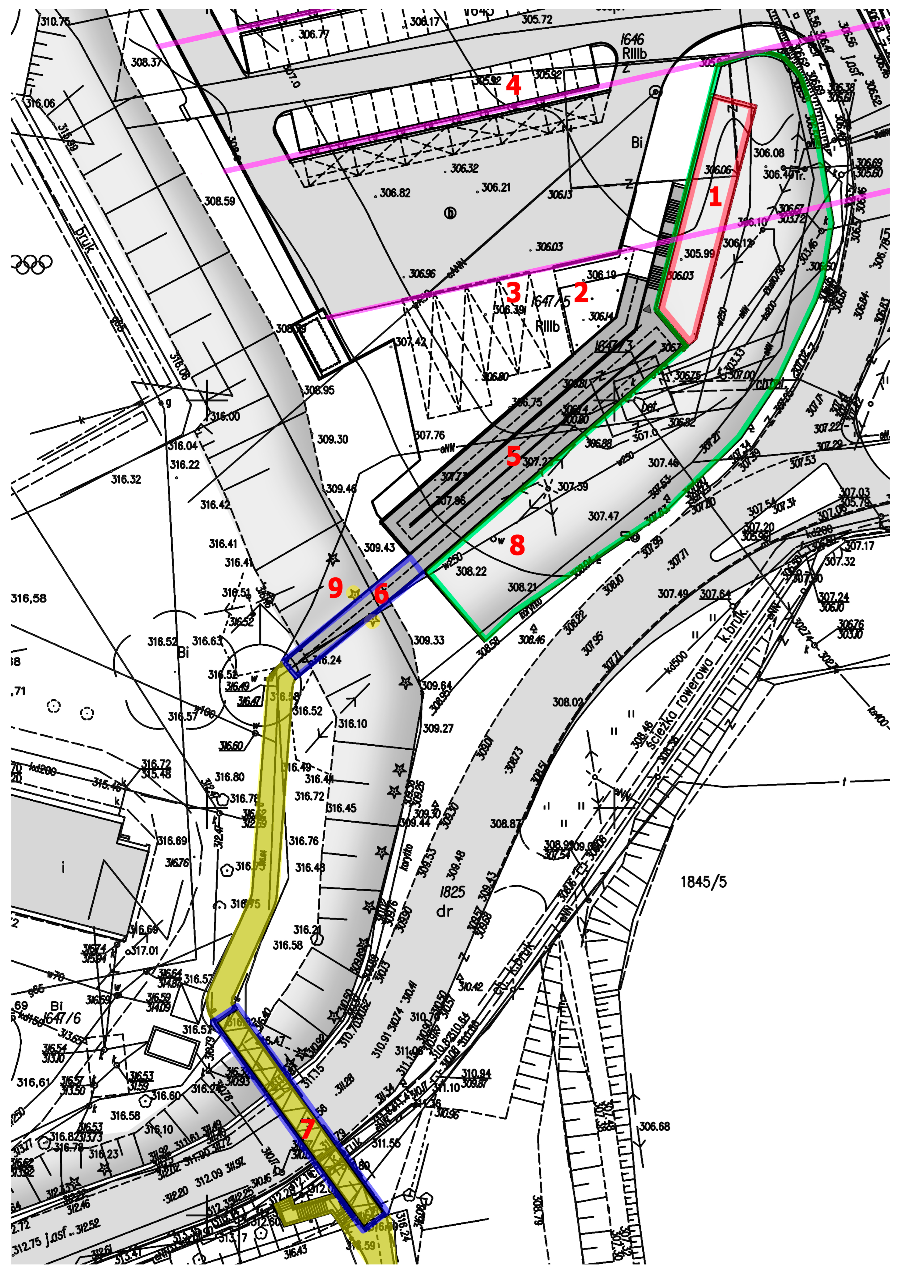
The pathway design required a series of solutions that were unusual for Park-and-Ride projects. The most demanding task was addressing the change in elevation along the pedestrian–cyclist route. It was assumed that the path should be fully accessible, including for those with reduced mobility, while avoiding mechanical devices to preserve the integrity of the historic experience. This necessitated the design of a system of ramps and two pedestrian–cycle footbridges (elements 2 and 3 in Figure 8). Constructing the footbridge over the main road required a detailed passive view analysis, considering its visibility from both the road and the market square.
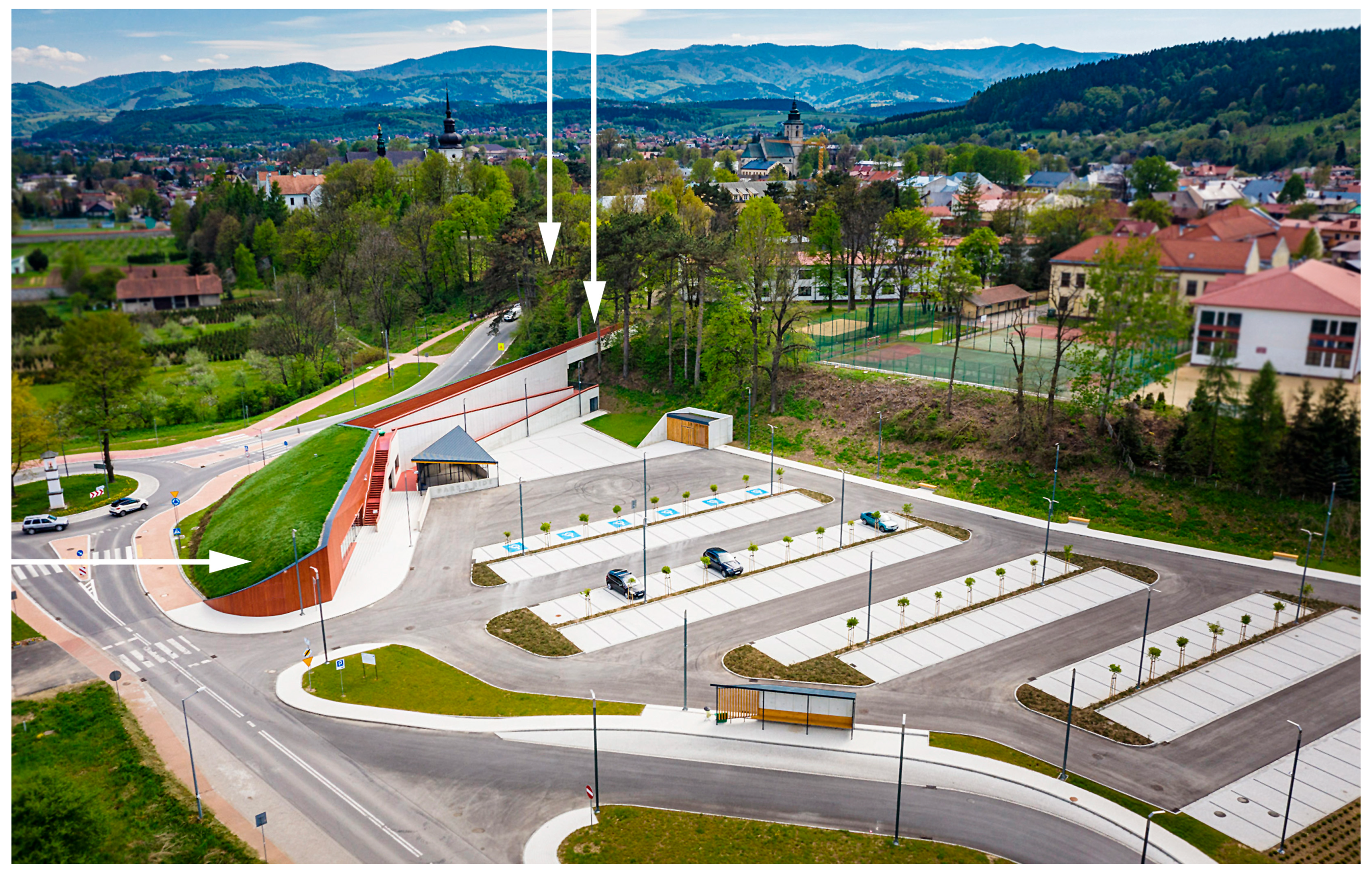
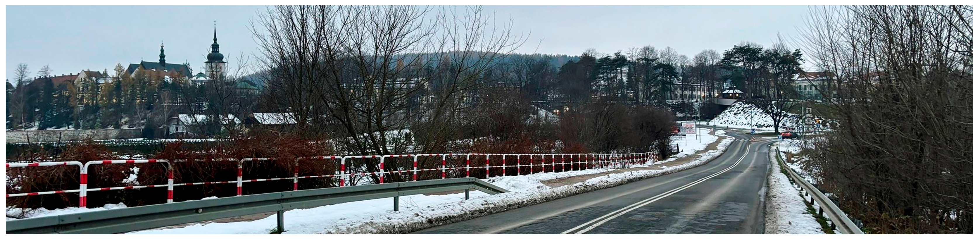
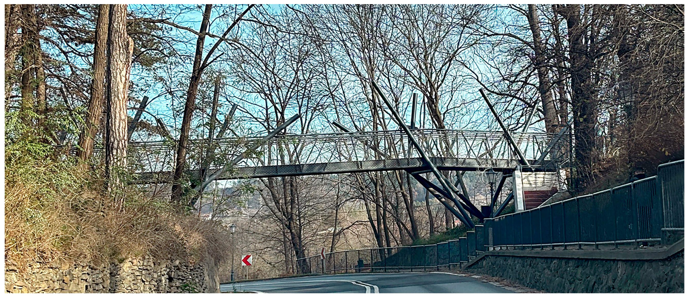
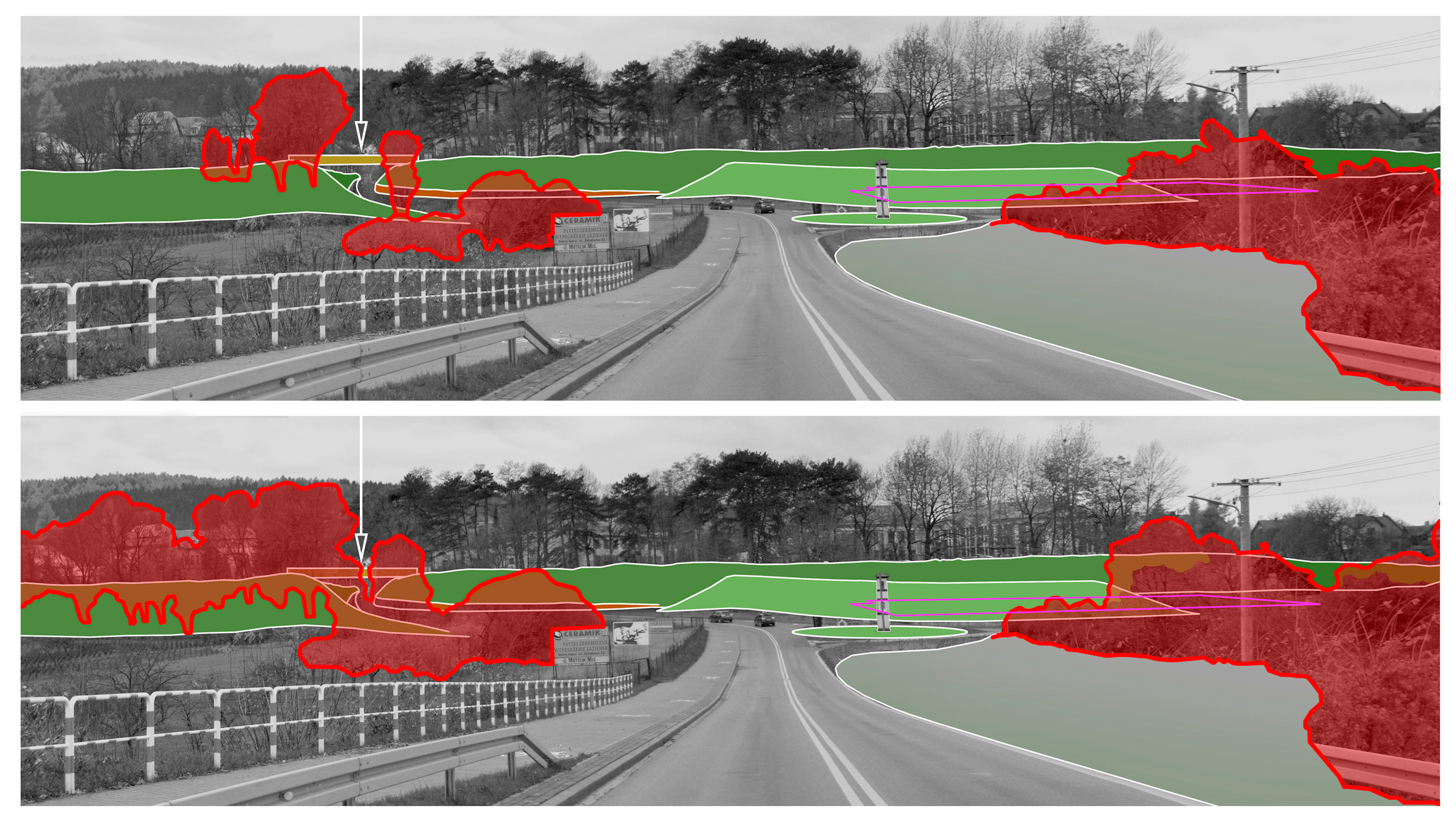
A view analysis from the approach road from Nowy Sącz enabled the selection of the optimum location for the crossing. Simulations confirmed that in the chosen position, only part of the structure would be visible in winter and it would be almost entirely concealed by foliage during the summer months (Figure 9).
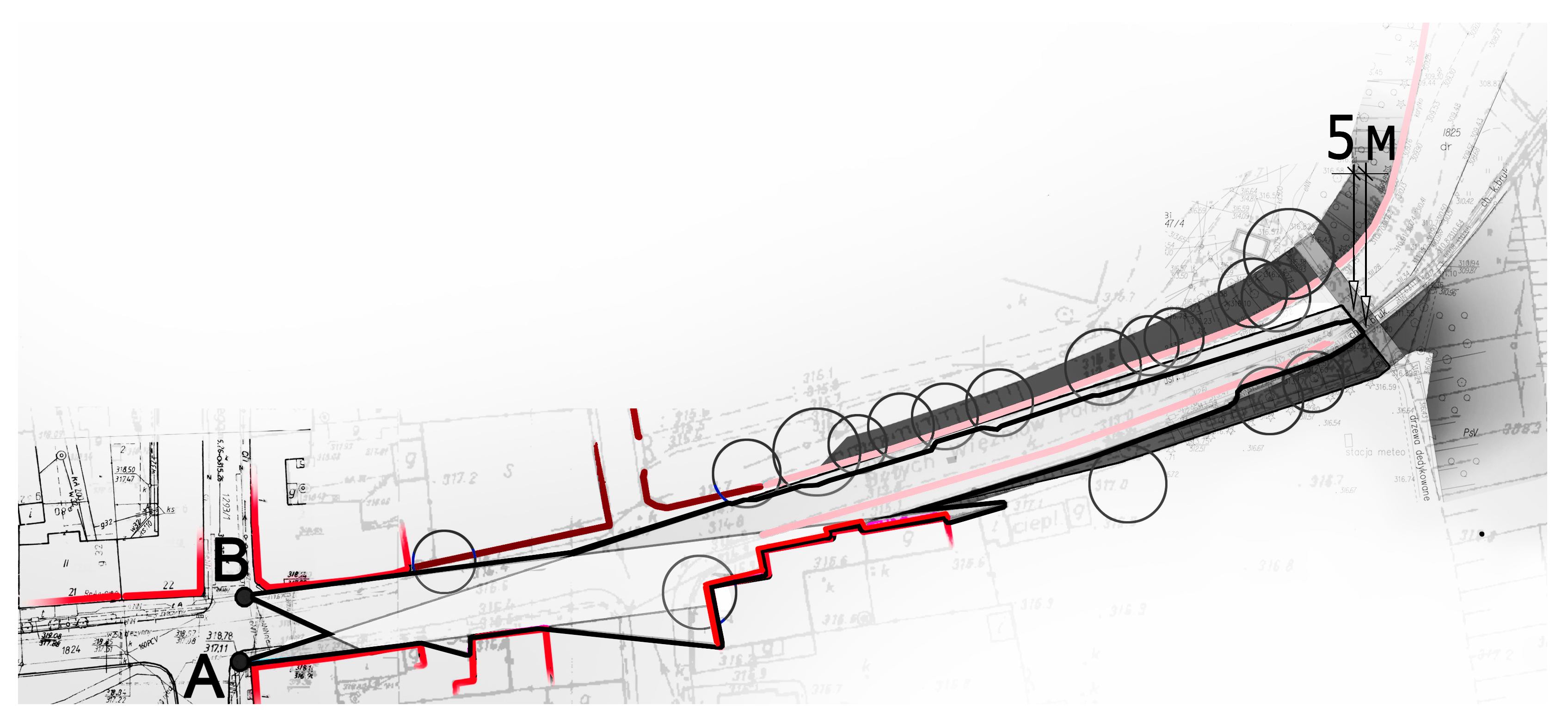
The visibility of the footbridge from the market square was also examined, assuming a designed height of the footbridge platform of 316.9 m above sea level. Points A and B were determined in the corners of the market square and their heights were determined—to be 318.78 m above sea level and 318.4 m above sea level, respectively. Consequently, an average viewpoint of 320.43 m above sea level was adopted. The simulation, taking into account the existing view limitations (buildings, solid fences, walls, trees and bushy slopes), allowed us to conclude that a section of maximum length of 5 m would appear in the field of view from the market square (at a distance of approx. 220 m from the footbridge) (Figure 10).
The results of the analyses were presented to the heritage authorities and approved in a two-step process—first by the Delegation Office in Nowy Sącz, and subsequently by the provincial authorities, following an expert review by the Regional Council for Monument Protection. Importantly, the project was submitted for evaluation as an undertaking intended to mitigate increasing tourist traffic in the centre of Stary Sącz (Protocol of the 7th Meeting of the Małopolska Provincial Monument Protection Council, 9 December 2015). It is unknown how experts would have evaluated the project had its sole purpose been to serve global sustainable transport objectives. Nevertheless, the view analyses and the clear local aim proved sufficient to overcome the anticipated objections expressed during pre-design consultations.
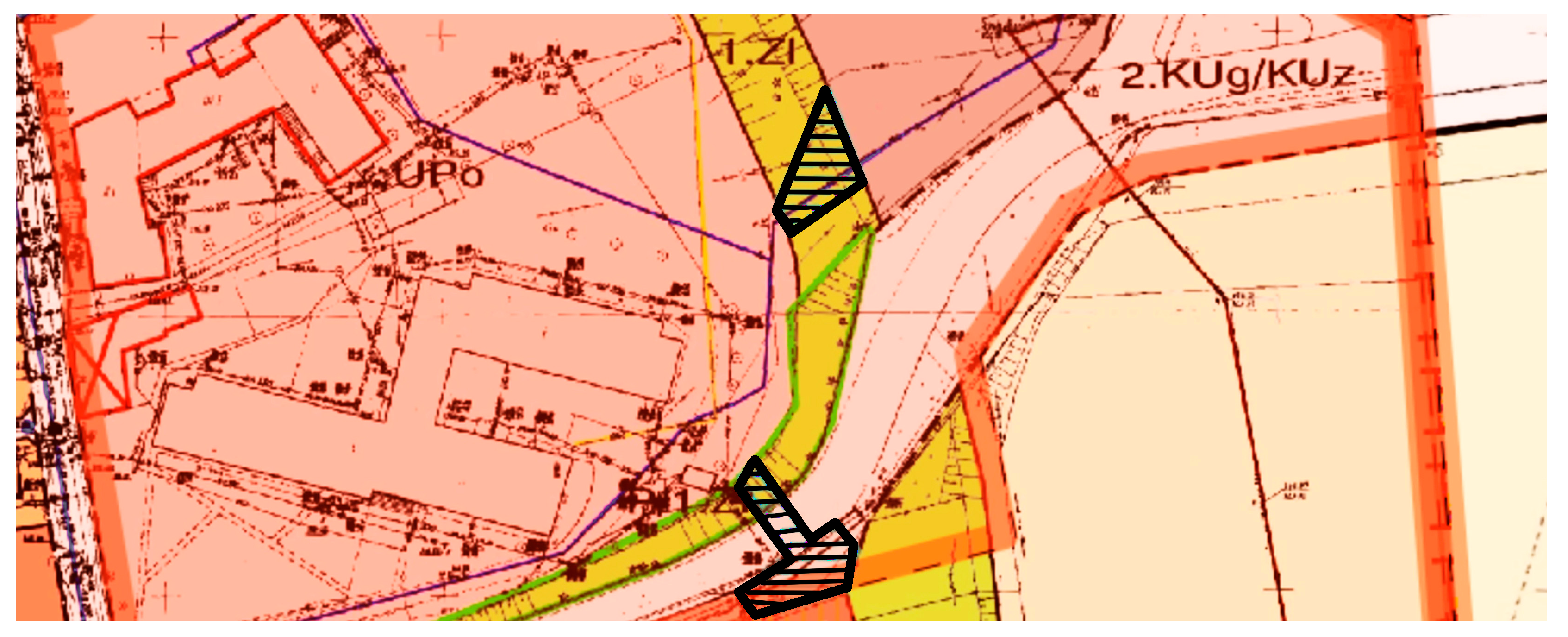
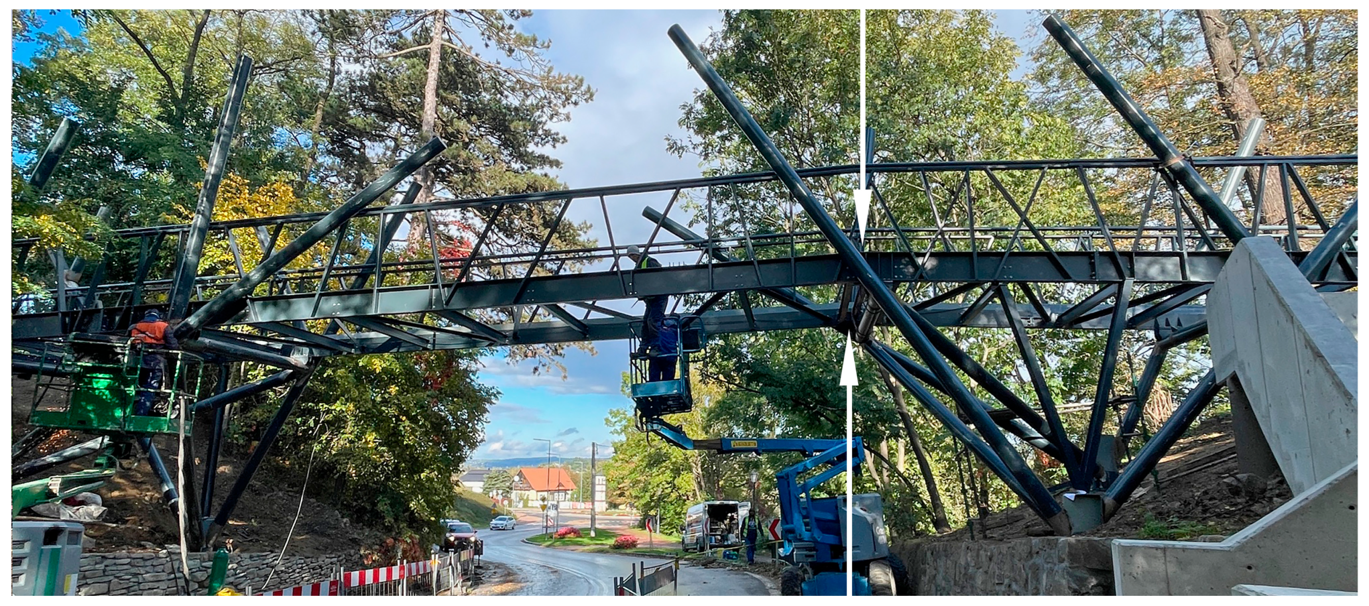
The proposed pedestrian–cycle link necessitated amendments to the Local Spatial Development Plan. These amendments allowed the construction of footbridges and paths within narrow corridors between protected trees, without compromising the stability of the scarp [51]. Notably, the mapped widths of the upper scarp zones were extremely narrow, and the base maps did not show the precise locations of protected trees. The plan further stipulated that the footbridge over the road could not exceed a height of 5.5 metres above carriageway level, imposing a significant constraint on possible structural solutions (Figure 11).

4.2.3. Architectural Concept

In arranging the parking bays, the design sought to better integrate the project with its surroundings by referencing the historical subdivision of the land. Bands of greenery were introduced between clusters of parking spaces, echoing the former parcel boundaries (Figure 12). The location of the facility required the construction of a passenger-service building and a small bus terminal. Following an assessment of design alternatives, a stand-alone building was rejected in favour of integrating the required rooms into the screening embankment on the car-park side (Figure 13, left). Owing to volumetric constraints set out in the Local Plan, the building occupies only a small portion of the embankment (Figure 13, right). The embankment rests on a retaining- wall, that also supports the pedestrian–cycle ramp enabling a barrier-free ascent to the level of the historic scarp. As the route was conceived as a choreographed spatial experience—a ritualised entry into the town—the height of the embankment and the retaining wall was designed to restrict initial views. Further along the ramp, a sequence of glimpses into the monastic gardens becomes visible, creating a controlled unfolding of the landscape (Figure 14).
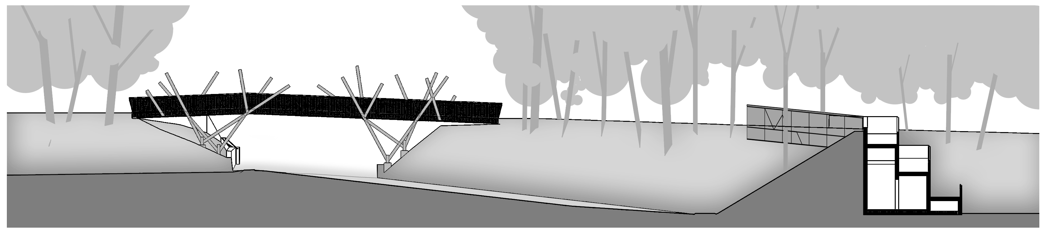
Beneath the ramps lies an existing, previously exposed pumping station. As part of the project, overhead cables were replaced with underground lines. A footbridge was designed between the uppermost section of the ramp and the crest of the scarp to avoid loading the historic slope directly (Figure 12, no. 6). The second footbridge (Figure 12, no. 7) was designed as an openwork structure, its supports deriving their form from the trunks of neighbouring trees, taking into account its partial—though nonetheless possible—visibility. As noted earlier, the height restriction of 5.5 metres imposed by the Local Plan was the second major factor influencing the form of the footbridge. To meet these requirements, the bridge was designed with branched supports reaching from multiple points, projecting beyond the abutments (Figure 15).

4.2.4. Project-Stage Challenges Associated with the Park-and-Ride Facility

The project, in its final form, extends far beyond conventional Park-and-Ride solutions. At the design stage, the principal challenge concerned financing. Only part of the work could be funded under the programme Expansion of the Low-Emission Public Transport System of the Sącz Agglomeration, which was directly linked to the implementation of global sustainability goals. Despite this, Stary Sącz authorities opted to realise the project as conceived, dividing it into two separate investments. The first—comprising the Park-and-Ride facility, the embankment with the integrated building and the bridge to the scarp—was built in 2018–2020 with EU support. In parallel, 55Architekci prepared technical documentation for the extension—namely the bridge over the main road and the cultural route—although funding sources for this second stage remained uncertain. The effort to align global goals with local objectives was tested once again when the first stage was opened. Between January 2020 [52] and November 2023 [53], the project effectively ended at the footbridge to the old- town scarp, with no continuation (see Figure 12).
Funding for the second phase was secured a year after the first phase investment opened [54]. The mechanism enabling continuation was the government programme Tarcza dla gmin górskich (Shield for Mountain Municipalities), which provided support for public tourism infrastructure and municipal services in mountain areas economically affected by COVID-19 restrictions [55]. The waiting period proved difficult for both authorities—who voiced their concerns in informal conversations with 55Architekci—and residents. Local commentary frequently questioned the project’s rationale, emphasising its perceived limited usefulness for Stary Sącz and modest impact on reducing emissions or traffic in Nowy Sącz (e.g., [50,56,57]).
Nevertheless, despite financial uncertainty, extended timelines and public criticism, the municipality did not abandon the project, nor did it abandon the components designed to address local needs. This persistence is significant in the context of this article—particularly given that the cultural route required negotiating land access with several property owners, a process unfolding under heightened public scrutiny.

4.3. Construction

4.3.1. Construction and Sustainable Development

The construction phase was dominated by efforts to ensure that the inclusive expansion of public space would protect both cultural and natural heritage—aligning indirectly with Sustainable Development Goal 11, Sustainable Cities and Communities [58].
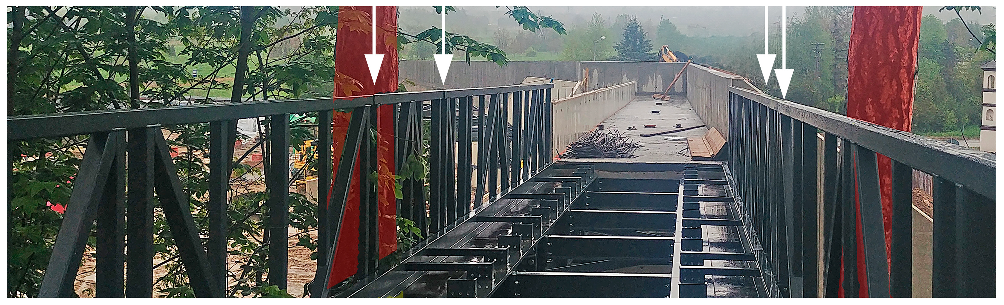
In the first stage, the most challenging task was building the bridge over the scarp between protected trees. The Local Spatial Development Plan designated only a very narrow area in which the bridge could be supported. As a result, the structure had to be inserted between protected pines, in some places only a few tens of centimetres from the trunks. Given that pines can sway significantly in strong winds, the bridge had to be designed to avoid damage from such movement while also preventing harm to the trees (e.g., from resisting their sway and causing trunk fracture). Consequently, the railings were designed so that individual segments could detach under extraordinary pressure (Figure 16).
In the second stage, the key issue was ensuring sufficient clearance above the road without exceeding the 5.5-metre height limit, set by the Local Plan (Figure 17). The bridge was therefore designed and built as two connected sections with different deck inclinations, allowing compliance with parameters while keeping structural elements shallow (36 cm). The safety margin between the predicted final clearance and the maximum allowable height was just 5 cm. The steel structure was manufactured in two parts and pre-assembled in the factory hall; however, the final on-site assembly—without any opportunity to adjust dimensions—posed a major technical challenge requiring exceptional precision.

4.3.2. Issues Related to Public Reception

As in the design phase, the construction period was marked by public scepticism about the purpose of the investment. The extended timeline, lack of an immediate link to the centre and the disruptions caused by the COVID-19 pandemic hindered early acceptance and use of the facility. Comments in local media frequently expressed doubts, often highlighting perceived limited benefits for the town (e.g., [59]). Systematic monitoring of parked vehicles, carried out by the municipality since January 2022, provides insight into usage. According to data provided for this article, average weekday occupancy was 76 cars in 2022 and 83 in 2023—approximately two-thirds of capacity. Weekend averages were 21 (2022) and 25 (2023). These figures indicate significantly higher weekday use and a modest upward trend overall.
Interviews with local officials and media statements revealed a recurring theme: insufficient communication about the project’s final form and objectives. Authorities informed residents about plans to build the pedestrian–cycling route to the market square [60], to reduce parking spaces in the town centre [61], and to relocate long-distance bus stops from the Market Square once the Park-and-Ride became fully operational [62]. The municipality also organised a slogan and advertising competition for local schoolchildren, promoting the Park-and-Ride as an eco-investment and awarding prizes to entries that emphasised its role in sustainable development [63].

4.3.3. Challenges Associated with Construction of the Park-and-Ride and Complementary Facilities

Technical challenges related to linking the project with the town did not directly impede construction of the component serving global transport-sustainability objectives. Even though the construction spanned several years, local authorities did not abandon either the globally oriented goals or the local complementary project. This required determination, political negotiation among councillors and resilience in the face of negative public reactions. Considerable care was devoted to shaping not only the project’s physical form but also its public image. Notably, additional funds were allocated during construction for installing an irrigation system on the screening embankment, reflecting a belief that high aesthetic quality and rapid achievement of the intended landscape form would help address public concerns.
As usage remained below expectations and behavioural change was limited, the municipality reinforced the promotion of global objectives through an educational campaign. Although the project had already received external support for meeting transport targets, local authorities considered it necessary to invest further in developing young residents’ knowledge and skills related to sustainable development—aligning with Sustainable Development Goal 4, Quality Education [64].

4.4. Use

4.4.1. Fulfilment of Sustainable Transport Goals After Completion of the Entire Project

According to data provided by the Municipality of Stary Sącz, weekday occupancy of the car park has remained at a similar level since the opening of the second stage. At the same time, weekend numbers have nearly doubled (reaching 48 cars in 2024). A correlation can therefore be observed between increased use of the Park-and-Ride and non-working days. This may suggest a growing proportion of users whose destination is Stary Sącz itself rather than commuters travelling to work or shopping in Nowy Sącz, as originally intended in the Park-and-Ride assumptions. This issue warrants further investigation.
Traffic-flow maps (e.g., on strava.com) indicate that cyclists now use the facility’s ramps. In contrast, before construction they avoided this area due to the lack of cycling infrastructure and heavy traffic on the adjacent road. The thematic pedestrian–cycling route running along the historic scarp, together with the small public space beside the monastery walls, has become a tourist attraction promoted in leaflets for visitors.

4.4.2. Additional Functions of the Completed Project

In addition to its important role within the expanding transport system, the completed Park-and-Ride (Figure 18 and Figure 19) serves several ancillary functions. It has become the venue for a new, popular and recurring regional event—the annual gathering of vintage-car enthusiasts [65]. According to reviews posted on Google.com, the car park is also a favoured location for photographing vehicles for sales listings and—albeit with mixed public sentiment—a meeting place for young people, drifting, skateboarding and parkour. The building embedded within the embankment, originally intended primarily as a waiting area and tourist information point, has also taken on occasional alternative functions—for example, as a free shop for refugees fleeing the war in Ukraine [66]. The possibility of adapting the space for emergency shelter use has likewise been considered.

4.4.3. Professional Reception

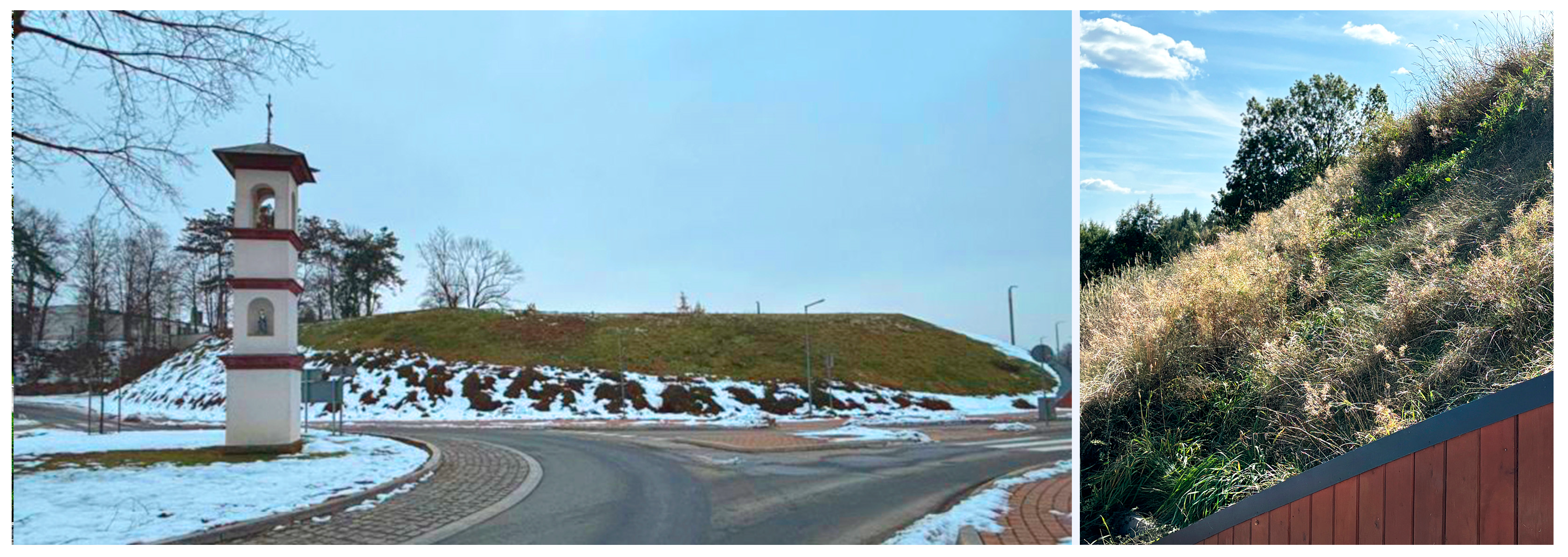
The Park-and-Ride and its cultural route received the 2024 Stanisław Witkiewicz Award of the Małopolska Voivodeship [68] in the public space category. The jury’s decision affirmed the appropriateness of the project’s scale and the value of conducting landscape analyses that account for seasonal variability in the natural environment, as well as the deliberate use of forms that echo those already present in the townscape (Figure 20 and Figure 21). The jury emphasised that giving transport infrastructure an architecturally refined expression and employing carefully selected materials has a direct, positive impact on the quality of everyday public space. The project also received recognition in an architects‘ vote organised by the Małopolska Chamber of Architects [69].
The awards significantly increased the project’s visibility. It has been described both as a model example of the effective use of EU funds and the implementation of global sustainability objectives (e.g., [70]) and as a solution to parking problems in the centre of Stary Sącz [67].

4.4.4. Post-Completion Challenges

The incomplete utilisation of the Park-and-Ride does not weaken the municipality’s conviction regarding the project’s value. It does, however, reinforce awareness of the need for further measures to better realise both global and local objectives. Efforts are currently underway to establish a new railway stop near the site [71], which could increase the number of commuters using public transport to Nowy Sącz and Kraków. Discussions are also ongoing concerning the development of adjacent plots, with projects aimed at increasing local engagement (for example, the planned swimming pool [72]).

5. Discussion—The Park-and-Ride as an Investment Linking Global and Local Policy Goals

The purpose of this study was to identify challenges associated with the local implementation of global sustainable development objectives. The processes and decisions surrounding the Park-and-Ride project were examined as examples of how local authorities attempt to meet external policy expectations while maintaining agency over their own territory.
Synthesising the key themes revealed in the study leads to the following conclusions:
  • The need to implement global sustainable development goals—especially the low-emission transport goal—may create opportunities to achieve local objectives previously identified but only loosely connected to the initial aims of a Park-and-Ride project.
  • While fulfilling global sustainability goals, a Park-and-Ride may simultaneously advance local aims through a strategic “piggybacking” effect.
  • Architectural solutions play a crucial role in enabling transport-infrastructure investments such as Park-and-Ride facilities, to serve a dual function: as elements of mobility systems and as conveyors of cultural meaning.

5.1. Sustainable Transport Facility as a Catalyst for Local Urban Transformation

Park-and-Rides facilities have received only limited attention in architectural and urban research. Studies typically focus on their position within urban and transport networks—shaped by multimodal connections, distance to destinations, travel times (e.g., [17,19]), and their potential to induce sprawl (e.g., [12]). The Stary Sącz case demonstrates the significant influence that transport infrastructure can have on its urban surroundings. The project served as a catalyst for changes extending into the historic town centre, within whose administrative boundaries it was located. This article argues that neglecting the influence of local political objectives—and treating the project solely as a response to global policy—prevents a full understanding of the role such investments play in the sustainable transformation of small historic towns. The case study shows that externally driven projects can create opportunities and inspire changes that would not have occurred without targeted external support. With the funding obtained, the municipality built not only a Park-and-Ride but also a bus station, a meeting place, a pocket public square and, crucially, an accessible cultural route separated from road traffic—connecting the Park-and-Ride directly to the market square. These interventions, as demonstrated by the case, are material in nature and may spark broader improvements that enhance both the image and sustainability of the municipality served by the Park-and-Ride and the one hosting it. In this case, they contributed to reducing parking in the historic centre and relocating long-distance bus services away from the market square.

5.2. Piggybacking on Sustainability Policy

It is widely acknowledged that local authorities frequently pursue their own objectives by drawing on external funds intended to deliver higher-level policy goals, the implementation of which they accept as mandatory (the cost of Park-and-Ride was ca. EUR 1.86 M (including EUR 1.18 M European funds). By diversifying the project and incorporating elements not directly related to its primary function (in this case, providing a parking facility linked to public transport), the municipality reduced the risk of public opposition to an investment perceived as offering few immediate benefits to local residents.
The Park-and-Ride serving Nowy Sącz was built in Stary Sącz and was presented—depending on the context—as either an initiative to improve environmental conditions and reduce congestion or as an investment to enhance the town’s tourist appeal and quality of life. A Park-and-Ride facility, which by definition does not directly benefit the host community, became an opportunity to implement long-discussed but previously unfunded local improvements. The availability of external resources triggered planning and design activities that enabled the alignment of local and supra-local interests. This mode of action corresponds to what has been described as a “piggybacking strategy” [73].
Analysis of the Park-and-Ride in Stary Sącz indicates that at every stage local authorities ensured that, while serving its regional function—reducing the traffic load in Nowy Sącz—the development would also meet local objectives: reducing the number of cars parked in the historic market square, creating a new tourist attraction through the cultural route, and enhancing public space. Throughout the process, decision-makers remained attentive to the conservation of natural and cultural heritage. The project’s final form reflects both the ambition to shift mobility habits and the strict requirements for protecting trees, the old- town scarp, the panorama and key views. Parking occupancy data indicate that behavioural change has not yet been fully achieved. Although the public transport network was expanded, actual utilisation remains below expectations, and there is no clear evidence of a reduction in traffic on the approach road to Nowy Sącz.
At the same time, the Park-and-Ride and its cultural route have acquired the status of authentic public space—serving as a venue for events, functioning as an attraction in its own right, and, following the awards received, appearing prominently in the town’s promotional materials. It is presumed that the transition from private car use to public transport will take longer and require ongoing educational efforts. In this respect, the investment has been treated as a strategic undertaking, comparable to the town’s bypass (completed in 2021). From the outset, representatives of the municipality anticipated that its transport-related benefits would be fully recognised only several years after completion [74]. This makes it even more significant that immediate, perceivable cultural, natural and aesthetic benefits were prioritised throughout the process.

5.3. The Role of Architectural Solutions

The ambition to highlight the town’s cultural, aesthetic and natural qualities decisively shaped the project’s final form. Architectural solutions—particularly those concerned with preserving the panorama—enabled the realisation of a development that, as the analysis suggests, would otherwise not have received heritage approval. A central argument of this article is that Park-and-Ride facilities, typically classified as engineering infrastructure, can be seen as contemporary analogues of historic town gates: spatial devices that structure the ritual of arrival and shape visitors’ perceptions. In the examined case, the authorities and designers deliberately curated this experience, guiding users from the car park towards the historic centre while emphasising key elements of local identity. The route over the old scarp, the passage beside mature trees, the bridge above the main road, the view corridor overlooking the monastery gardens and the small pocket square marking a shift in direction—all these elements, through their spatial composition and visual relationships, communicate the character of the town.
Visual simulation techniques were used to test the validity of design decisions. Crucially, the simulations included seasonal changes in vegetation—an aspect often overlooked and not legally required. The strong correspondence between the simulations and post-completion views (see Figure 9 and Figure 19) indicates that the adopted method was sufficiently accurate for assessing potential impacts on passive exposure of the silhouette.
Recognition of the Park-and-Ride and its route as a high-quality public space—confirmed by professional awards—challenges conventional assumptions that transport infrastructure undermines social interaction. The case shows how an intervention that responds to motorists’ needs can redefine which spaces are considered socially meaningful. By giving the facility an aesthetically compelling form and incorporating it into promotional narratives, the project encourages users to form their own views on sustainable mobility while highlighting the local benefits of engaging with global sustainability frameworks.
Overall, the findings underline the important role of architectural solutions in the design of transport infrastructure that supports sustainable mobility. They highlight the value of embedding local cultural identity within engineering projects and demonstrate that efforts to balance transport systems through Park-and-Ride facilities can serve as a catalyst for broader urban and social transformation.

5.4. Study Limitations and Future Research

This case study identifies issues relevant for determining the premises and recognising the challenges associated with implementing Park-and-Ride facilities in small towns with rich natural and cultural assets. However, several limitations may influence the interpretation of the findings.
The primary limitation stems from the nature of the specific context of the analysed Park-and-Ride (with strong historical heritage assets) and research-through-design method. Active involvement of designers and researchers in the project—despite efforts to maintain impartiality—may influence the decisions of other actors in the design and construction process.
The study did not examine how the involvement of designers and researchers might affect other stakeholders’ decisions. The research was carried out in a small town with abundant and highly valued historical fabric, where the authorities are well aware of its tourist potential and of their own role in maintaining it. The municipality has a long tradition of policies aimed at preserving landscape qualities and protecting the town silhouette (cf. [49]). Current decision-makers act as both signatories of conservation agreements and guardians of long-established planning principles—for example, concerning the treatment of the visual foreground. It is also important to note that during the project’s realisation the same leadership held office for several terms, enjoying relatively strong public support due to earlier, well-regarded spatial decisions. It may therefore be assumed that they were more able and willing to make decisions that could be unpopular. In towns lacking a strong historical identity, or where political power is less established, representatives have limited experience; the findings might differ—for instance, showing a weaker influence of local policy or even a negative impact on the feasibility of supra-local sustainability goals.
In a town with lower tourist potential, the use of such transport infrastructure might be negligible. The study did not investigate who the actual users of the facility are, how usage varies daily and weekly (the analysis is based on monthly statistics), and how cultural heritage influences parking decisions—though this merits attention.
The analysis of user perceptions was based on online comments and posts; this group cannot be considered fully representative. The themes identified should therefore be regarded as indicative rather than definitive, pending further research with larger and more diverse respondent groups.
The study also identified the need for research on how the realisation and subsequent awards of the Park-and-Ride—highlighting it as a model for implementing supra-local sustainable transport policy—may influence public attitudes towards future initiatives of this type. Plans for another Park-and-Ride in Stary Sącz, accompanied by a notable decline in pessimistic comments compared with those surrounding the project analysed here, suggest that the outcomes of this emerging “experiment” may be promising [75].
It is already known that the cultural route from the Park-and-Ride to the market square influenced the architectural form of a cultural facility later constructed by the municipality nearby. The relationship between these interventions and their positioning within local and global sustainability frameworks indicates a compelling direction for future research.
Overall, the influence of local political authority on spatial solutions designed to fulfil supra-local objectives remains understudied. The findings presented here are treated as paradigmatic—providing a basis for examining other local projects undertaken within the framework of wider policy agendas. Park-and-Ride facilities are certainly not the only interventions capable of yielding insights into how projects supporting sustainable spatial transformation are shaped. The results may inform future developments and the evaluation of existing ones, pointing towards a promising field for further inquiry.

6. Conclusions: Transport Infrastructure as Complex Forms of Diverse Communication

The study presented in this article is particularly timely, given that the implementation of the Sustainable Development Goals has become a central concern of global policy and increasingly depends on initiatives undertaken at the local level. Investments associated with sustainable transport policy can contribute not only to the transformation of mobility systems within urban centres, but also to more far-reaching, sustainable changes in adjacent areas—extending well beyond the transport sector itself.
The case of the Park-and-Ride facility in Stary Sącz demonstrates the following:
  • A transport-infrastructure project can become a space for mediating between local and global sustainability imperatives, exceeding the narrow remit of improving transport efficiency alone, and can serve as a catalyst for reshaping urban structure and foregrounding cultural and natural values.
  • The form of the project expresses, in material space, political decisions (collectively endorsed by elected representatives), ethical commitments (a sense of responsibility for the common good and a readiness to take unpopular decisions), aesthetic ideals (manifest in an uncompromising approach to protecting the town’s landscape identity) and social relations (the capacity to maintain public support throughout a lengthy and complex process). The Park-and-Ride in Stary Sącz is at once an engineering project, an architectural project and a political project—a material manifestation of decisions taken by representatives entrusted with governing shared space in line with both global and local sustainability goals.
  • Seasonal analyses of passive exposure, together with a landscape-integrated architectural form, were crucial in securing approval for, and ultimately realising, the project.
Finally, this study demonstrates that transport infrastructure—exemplified here by the Park-and-Ride facility—can function as a dual form of communication: it organises the city by enabling the sustainable movement of people and goods whilst at the same time conveying cultural meaning. Transport policy, particularly at supra-local scales, is still often regarded primarily as a matter of legal instruments—immaterial or materialised only through standardised and conventional solutions [76]. This study addresses that gap by offering an example of a spatial intervention in which the built form itself embodies the community’s need to govern the territory it inhabits. It also draws attention to how efforts to achieve sustainable development in one (typically larger) urban centre may shape the development trajectories of other, geographically connected localities.

Author Contributions

Conceptualisation, A.S.-Ś. and W.Ś.; methodology, A.S.-Ś.; validation, A.S.-Ś. and W.Ś.; formal analysis, A.S.-Ś.; investigation, A.S.-Ś.; resources, A.S.-Ś. and W.Ś.; data curation, A.S.-Ś. and W.Ś.; writing—original draft preparation, A.S.-Ś.; writing—review and editing, A.S.-Ś. and W.Ś.; visualisation, A.S.-Ś. and W.Ś.; supervision, A.S.-Ś.; project administration, A.S.-Ś.; funding acquisition, A.S.-Ś. All authors have read and agreed to the published version of the manuscript.

Funding

This research was funded by the Initiative for Excellence—Research University at AGH University of Krakow.

Institutional Review Board Statement

The interviews in this article do not include any personal information of the interviewees. The purpose is to obtain the necessary information for leading the design process—the standard guidelines for design provided by the investors in building or design.

Informed Consent Statement

Informed consent was obtained from all subjects involved in the study.

Data Availability Statement

Data is contained within the article.

Acknowledgments

The author thanks the anonymous reviewers and the academic editor for their comments and suggestions.

Conflicts of Interest

The authors declare no conflicts of interest. The funders had no role in the design of the study; in the collection, analyses, or interpretation of data; in the writing of the manuscript; or in the decision to publish the results.

References

  1. GUS. SDG. In SDG in Numbers. 10 Years of the 2030 Agenda in Poland; GUS: Warsaw, Poland, 2025. Available online: https://stat.gov.pl/obszary-tematyczne/inne-opracowania/inne-opracowania-zbiorcze/sdg-w-liczbach-10-lat-agendy-2030-w-polsce,54,1.html (accessed on 31 October 2025). (In Polish)
  2. GUS. SDG Report. Goal 11—Sustainable Cities & Communities. Indicator 11.1.e—Transport of Passengers per 1 Inhabitant of Urban Areas. Available online: https://sdg.gov.pl/en/statistics_nat/11-1-e/ (accessed on 31 October 2025).
  3. Grants Map EU. Development of the Low-Emission Public Transport System in the Sącz Agglomeration. Available online: https://mapadotacji.gov.pl/projekty/761858/?lang=en (accessed on 31 October 2025).
  4. UNEP/GRID-Warszawa. Eco-Miasto 2021; Centrum UNEP/GRID: Warszawa, Poland, 2022; Available online: https://www.gridw.pl/media/download/62bedf79e9f33_publikacja2021WEBv1.3.pdf (accessed on 31 October 2025).
  5. UN Department of Social Affairs. Sustainable Development. The 17 Goals. Available online: https://sdgs.un.org/goals/goal11 (accessed on 24 October 2025).[Green Version]
  6. Eurostat. Passenger Cars, by Type of Motor Energy and Size of Engine. 2025. Available online: https://doi.org/10.2908/ROAD_EQS_CARMOT (accessed on 24 October 2025).
  7. Ortega, J.; Tóth, J.; Péter, T. Planning a Park and Ride System: A Literature Review. Future Transp. 2021, 1, 82–98. [Google Scholar] [CrossRef]
  8. Palaguachi, J.; Padilla, M.; Ortega, M.; Solorzano, M.R.; Uvidia, R.V.; Ortega, J.; Veloz-Cherrez, D. Evaluating the Location of the Park-and-Ride System Using Multi-Criteria Methods: A Systematic Review. Sustainability 2024, 16, 10187. [Google Scholar] [CrossRef]
  9. Obaid, M.; Torok, A.; Ortega, J. A Comprehensive Emissions Model Combining Autonomous Vehicles with Park and Ride and Electric Vehicle Transportation Policies. Sustainability 2021, 13, 4653. [Google Scholar] [CrossRef]
  10. Nakamura, A.; Ferracina, F.; Sakata, N.; Noguchi, T.; Ando, H. Reducing Total Trip Time and Vehicle Emission through Park-and-Ride—Methods and case-study. J. Clean. Prod. 2025, 493, 144860. [Google Scholar] [CrossRef]
  11. Zijlstra, T.; Vanoutrive, T.; Verhetsel, A. A meta-analysis of the effectiveness of park-and-ride facilities. Eur. J. Transp. Infrastruct. Res. 2015, 15, 597–612. [Google Scholar] [CrossRef]
  12. Schwarzbauer, W.; Koch, P.; Martin Wolf, W. Park & Ride facilities and suburban sprawl. Eur. Plan. Stud. 2022, 30, 1378–1398. [Google Scholar]
  13. Miao, H.; Guan, H.; Han, Y.; Wang, H. Research of Park and Ride Parking Spaces Tiered Pricing Methodology Based on Subway Ride Distance. Appl. Sci. 2024, 14, 3550. [Google Scholar] [CrossRef]
  14. Stieffenhofer, K.E.; Barton, M.; Gayah, V.V. Assessing Park-and-Ride Efficiency and User Reactions to Parking Management Strategies. J. Public Transp. 2016, 19, 75–92. [Google Scholar] [CrossRef]
  15. Shoup, D. Parking Benefit Districts. J. Plan. Educ. Res. 2023, 44, 2154–2166. [Google Scholar] [CrossRef]
  16. Spillar, R. Park-and-Ride Planning and Design Guidelines; Parsons Brinckerhoff Inc.: New York, NY, USA, 1997; Available online: https://www.caminoscastillayleon.es/wp-content/uploads/Transportes/Park-and-Ride%20Planning%20and%20Design%20Guidelines%20(1995).pdf (accessed on 29 October 2025).
  17. Szarata, A. Analiza wielkości parkingów Park and Ride zlokalizowanych w obszarach metropolitalnych. Bud. I Archit. 2014, 13, 267–274. [Google Scholar] [CrossRef]
  18. Paslawski, J.; Rudnicki, T. Flexible design of Park-and-Ride facility in the city center proximity. Arch. Civ. Eng. 2021, 67, 511––26. [Google Scholar] [CrossRef]
  19. Ortega, J.; Uvidia, R.V. Mathematical Models Applied to the Localization of Park-and-Ride Systems: A Systematic Review. Vehicles 2025, 7, 46. [Google Scholar] [CrossRef]
  20. Acuña, R. End of the line: The impact of new suburban rail stations on housing prices. J. Transp. Land Use 2023, 16, 67–86. [Google Scholar] [CrossRef]
  21. Shoup, D. The High Cost of Free Parking, 3rd ed.; Routledge: New York, NY, USA, 2019; pp. 623–668. [Google Scholar]
  22. Eran, B.-J. ReThinking a Lot: The Design and Culture of Parking; MIT Press: Boston, MA, USA, 2012. [Google Scholar]
  23. Overmeyer, K.; Misselwitz, P. Urban Catalyst the Power of Temporary Use; DOM Publishers: Berlin, DE, USA, 2013. [Google Scholar]
  24. InterregEurope. The Use of Park and Ride as a Strategy for Tourist Arrivals to the Destination. Available online: https://www.interregeurope.eu/good-practices/the-use-of-park-and-ride-as-a-strategy-for-tourist-arrivals-to-the-destination (accessed on 10 November 2025).
  25. Jacobs, J. The Death and Life of Great American Cities; Random House: New York, NY, USA, 1961. [Google Scholar]
  26. Atlas, R.I. 21st Century Security and CPTED. Designing for Critical Infrastructure Protection and Crime Prevention, 2nd ed.; CRC Press, Taylor and Francis Group: Fort Lauderdale, FL, USA; Boca Raton, FL, USA, 2013. [Google Scholar]
  27. Donovan, K.; Mould, T. The Parking Lot: An Oasis for Youth. Digital or Visual Products. 2004. Available online: https://www.folkstreams.net/films/parking-lot (accessed on 9 November 2025).
  28. Van Hecke, L.; Verhoeven, H.; Clarys, P.; Van Dyck, D.; Van de Weghe, N.; Baert, T.; Deforche, B.; Van Cauwenberg, J. Factors related with public open space use among adolescents: A study using GPS and accelerometers. Int. J. Health Geogr. 2018, 17, 3. [Google Scholar] [CrossRef] [PubMed]
  29. The MIT Press Reader; Eran, B.-J. From Chaos to Order: A Brief Cultural History of the Parking Lot. Available online: https://thereader.mitpress.mit.edu/brief-cultural-history-of-the-parking-lot/ (accessed on 10 November 2025).
  30. Zarząd Transportu Publicznego w Krakowie (Public Transport Authority in Kraków). P+R Car Parks. Available online: https://ztp.krakow.pl/en/park-and-ride/pr-car-parks (accessed on 10 November 2025).
  31. Onet.pl. Protest Przeciwko Budowie Parkingu Park&Ride w Płaszowie (Protest Against the Construction of a Park&Ride Parking Lot in Płaszów). Available online: https://wiadomosci.onet.pl/krakow/protest-przeciwko-budowie-parkingu-parkandride-w-plaszowie/qqws6e3 (accessed on 10 November 2025). (In Polish)
  32. Zieliński, J.; Tutka, P.; Kunikowski, P.; Szyszło, A. Ruch Drogowy 2020/2021 (Road Traffic 2020/2021); Generalna Dyrekcja Dróg Krajowych i Autostrad (General Directorate for National Roads and Motorways): Warszawa, Poland, 2022. (In Polish) [Google Scholar]
  33. Generalna Dyrekcja Dróg Krajowych i Autostrad (General Directorate for National Roads and Motorways). Mapa z Wielkością SDRR na Drogach Krajowych i Wojewódzkich w GPR 2020/21 (Map Showing the Size of SDRR on National and Provincial Roads in GPR 2020/21). Available online: https://www.gov.pl/web/gddkia/generalny-pomiar-ruchu-20202021 (accessed on 25 December 2025). (In Polish)
  34. Statistical Office in Krakow. Statistical Guidebook—City of Nowy Sącz 2025. Available online: https://krakow.stat.gov.pl/en/publications/other-studies/statistical-guidebook-city-of-nowy-sacz-2025,4,18.html (accessed on 11 November 2025). (In Polish)
  35. Fundusze Europejskie dla Małopolski 2021–2027 (European Funds Portal for Malopolska 2021–2027). Strategia Zintegrowanych Inwestycji Terytorialnych dla Sądeckiego Obszaru Funkcjonalnego na lata 2021-2027 (Strategy of Integrated Territorial Investments for the Sądecki Functional Area for 2021–2027). Nowy Sącz, 22 May 2025. Available online: https://fundusze.malopolska.pl/sites/default/files/2025/06/8748/Zalacznik%20nr%201%20do%20uchwaly%2022.05%20strategia%20zit%20sof.pdf (accessed on 11 November 2025). (In Polish)
  36. Dziennik Urzędowy Województwa Małopolskiego (Official Journal of the Małopolska Voivodeship). Uchwała nr XXXVIII/424/2020 Rady Miasta Nowgo Sacza z Dnia 29 Grudnia 2020 Roku w Sprawie Przyjęcia, Gminnego Programu Opieki nad Zabytkami Miasta Nowy Sącz na Lata 2020–2023 (Resolution No. XXXVIII/424/2020 of the Nowy Sącz City Council of 29 December 2020 on the Adoption of the “Municipal Programme for the Care of Monuments of the City of Nowy Sącz for the years 2020–2023”). Kraków, 1 August 2021. Available online: http://g.ekspert.infor.pl/p/_dane/akty_pdf/U80/2021/8/227.pdf (accessed on 11 November 2025). (In Polish)
  37. Beiersdorf, Z.; Krasnowolski, B. Stary Sącz: Zarys Historii Rozwoju Przestrzennego (Stary Sącz: Outline of the History of Spatial Development); Wydawnictwo Literackie: Kraków, Poland, 1985. (In Polish) [Google Scholar]
  38. Dziennik Ustaw 2003, 162, 1568 Ustawa z 23 Lipca 2003 o Ochronie Zabytków i Opiece nad Zabytkami, z Późniejszymi Zmianami (Journal of Laws 2003, 162, 1568. Act of 23 July 2003 on the Protection and Care of Monuments, with Subsequent Changes). Available online: https://isap.sejm.gov.pl/isap.nsf/download.xsp/WDU20031621568/U/D20031568Lj.pdf (accessed on 14 November 2025). (In Polish)
  39. Agamben, G. What Is a Paradigm? In The Signature of All Things: On Method; Agamben, G., Ed.; Zone Books: New York, NY, USA, 2009; pp. 9–32. [Google Scholar]
  40. Vargas, C.M.; Cooper, P.J. Implementing Sustainable Development. From Global Policy to Local Action, 2nd ed.; Bloomsbury Publishing: London, UK, 2024. [Google Scholar]
  41. Frayling, C. Research in Art and Design. R. Coll. Arts Pap. 2014, 1, 1–5. [Google Scholar]
  42. Krier, R. Urban Space, 5th ed.; Academy Editions: London, UK, 1991; Available online: https://robkrier.de/urban-space-engl.php#page-002-003 (accessed on 15 November 2025).
  43. Rossi, A. The Architecture of the City; The MIT Press: Cambridge, MA, USA; London, UK, 1982. [Google Scholar]
  44. Lynch, K. The Image of the City, 12th ed.; The MIT Press: Cambridge, MA, USA; London, UK, 1990. [Google Scholar]
  45. Bogdanowski, J. Metoda Jednostek i Wnętrz Architektonczno-Krajobrazowych (JARK-WAK) w Studiach i Projektowaniu (Podstawowe Wiadomości), wyd. 4 (The Method of Landscape Architecture Units and Interiors in Study and Design (Basic Knowledge), 4th ed.; Cracow University of Technology: Kraków, Poland, 1999. (In Polish) [Google Scholar]
  46. Till, J. The Negotiation of Hope. In Architecture and Participation; Blundell Jones, P., Petrescu, D., Till, J., Eds.; Routledge: London, UK, 2005; pp. 25–44. Available online: https://jeremytill.s3.amazonaws.com/uploads/post/attachment/19/2005_The_Negotiation_of_Hope.pdf (accessed on 17 November 2025).
  47. Babbie, E. The Practice of Social Research, 9th ed.; Wadsworth/Thomson Learning: Belmont, OH, USA, 2001. [Google Scholar]
  48. Beiersdorf, Z.; Krasnowolski, B.; Noga, Z. Stary Sącz. In Historical Atlas of Polish Towns; Noga, Z., Czaja, R., Eds.; Antykwa: Kraków, Poland, 2018; Volume 5, pp. 23–34. Available online: https://atlasmiast.umk.pl/pliki/stary_sacz/AHMP_Stary_Sacz_intro.pdf (accessed on 22 November 2025).
  49. Starosądeckie.info. Sądecki Skrót: Jak Burmistrz Roman Cesarczyk “Uratował” Panoramę Klasztoru ss. Klarysek (How Mayor Roman Cesarczyk “Saved” the Panorama of the Poor Clares Monastery). Available online: https://www.starosadeckie.info/spacerownik/sadecki-skrot-jak-burmistrz-roman-cesarczyk-uratowal-panorame-klasztoru-ss-klarysek/ (accessed on 22 November 2025). (In Polish)
  50. Starosadeckie.info. Zaparkujesz i Pojedziesz Czyli Park&Ride w Starym Sączu (You will Park and Ride or Park&Ride in Stary Sącz). 2 November 2015. Available online: https://nowysacz.naszemiasto.pl/pod-ogrodami-ma-byc-parking-dalej-starosadeczanie-pojada/ar/c4-3560801 (accessed on 22 November 2025). (In Polish)
  51. Miejscowy Plan Zagospodarowania Przestrzennego Gminy Stary Sącz. Uchwała nr IV/71/2018 (Local Spatial Development Plan for the Stary Sącz Commune. Resolution No. IV/71/2018). Available online: https://rastry.gison.pl/mpzp-public/starysacz/uchwaly/U_2018_71_IV.pdf (accessed on 24 November 2025). (In Polish)
  52. Dts.24. Już jest! Park & Ride w Starym Sączu Oficjalnie Otwarty (It’s Finally Here! Park & Ride in Stary Sącz is Officially Open!). Available online: https://www.dts24.pl/juz-jest-park-ride-w-starym-saczu-oficjalnie-otwarty/ (accessed on 25 November 2025). (In Polish)
  53. Dts.24. Stary Sącz. Kładka nad ul. Jana Pawła II gotowa (Stary Sącz. The Footbridge over Jana Pawła II Street Is Ready). Available online: https://www.dts24.pl/stary-sacz-kladka-nad-ul-jana-pawla-ii-gotowa/ (accessed on 25 November 2025). (In Polish)
  54. Sądeczanin.info. Stary Sącz Zgarnie aż 8 Milionów na Inwestycje Turystyczne i Skate Park (Stary Sącz will Receive as Much as PLN 8 Million for Tourism Investments and a Skate Park). Available online: https://sadeczanin.info/gospodarka/stary-sacz-zgarnie-az-8-milionow-na-inwestycje-turystyczne-i-skate-park (accessed on 25 November 2025). (In Polish)
  55. Gov.pl. Serwis Rzeczypospolitej Polskiej (Service of the Republic of Poland). Gminy Położone na Terenach Górskich Otrzymają Wsparcie (Municipalities Located in Mountainous Areas will Receive Support). Available online: https://www.gov.pl/web/rozwoj-technologia/gminy-polozne-na-terenach-gorskich-otrzymaja-wsparcie (accessed on 25 November 2025). (In Polish)
  56. Starosadeckie.info. Park and Ride po Starosądecku. Zaparkuj i Przesiądź się do MPK (Park and Ride the Stary Sącz way. Park and Transfer to Public Transport). Available online: https://www.starosadeckie.info/wydarzenia/park-and-ride-starosadecku-zaparkuj-przesiadz-sie-mpk/ (accessed on 25 November 2025). (In Polish)
  57. Starosadeckie.info. Stary Sącz. Centrum Miasta Czeka Reorganizacja? (Stary Sącz. Is the Town Center Facing Reorganisation?). Available online: https://www.starosadeckie.info/wydarzenia/stary-sacz-centrum-miasta-czeka-reorganizacja/ (accessed on 25 November 2025). (In Polish)
  58. UNDP. The Sustainable Development Goals. Goal 11. Available online: https://www.undp.org/sustainable-development-goals/sustainable-cities-and-communities (accessed on 27 November 2025).
  59. Gazeta Krakowska. Park & Ride w Starym Sączu Świeci Pustkami. To Niewypał Inwestycyjny czy Innowacja, do Której Mieszkańcy Muszą Dojrzeć? (The Park & Ride in Stary Sącz is Empty. Is it an Investment Failure or an Innovation that Residents need to Grow Into?). Available online: https://gazetakrakowska.pl/park-ride-w-starym-saczu-swieci-pustkami-to-niewypal-inwestycyjny-czy-innowacja-do-ktorej-mieszkancy-musza-dojrzec-zdjecia/ar/c1-15696776 (accessed on 25 November 2025). (In Polish)
  60. Eska Radio. Ogromny Parking Stoi Pusty. Władze Gminy Mają Pomysł Jak Go Ożywić (The Huge Parking Lot Sits Empty. Municipal Authorities have an Idea on How to Revitalize It). Available online: https://nowy-sacz.eska.pl/ogromny-parking-stoi-pusty-wladze-gminy-maja-pomysl-jak-go-ozywic-aa-DxBm-qgUi-wKiS.html (accessed on 27 November 2025). (In Polish)
  61. Gazeta Krakowska. Stary Sącz. Szykują Zmiany Organizacji Ruchu w Centrum Miasta (Stary Sącz. Traffic Changes Are Being Planned in the City Center). Available online: https://gazetakrakowska.pl/stary-sacz-szykuja-zmiany-organizacji-ruchu-w-centrum-miasta/ar/c1-14776612 (accessed on 27 November 2025). (In Polish)
  62. Staosadeckie.info. Autobusy Dalekobieżne Zatrzymają Się TYLKO na Park&Ride (Long-Distance Buses will Stop ONLY at Park&Ride). Available online: https://www.starosadeckie.info/wydarzenia/autobusy-dalekobiezne-zatrzymaja-sie-tylko-na-parkride/ (accessed on 27 November 2025). (In Polish)
  63. Gmina Stary Sącz (Stary Sącz Commune). Park&Ride. Available online: https://starysacz.um.gov.pl/park-ride/ (accessed on 27 November 2025). (In Polish)
  64. UNDP. The Sustainable Development Goals. Goal 4. Available online: https://www.undp.org/sustainable-development-goals/quality-education (accessed on 27 November 2025).
  65. Nowysacz.naszemiasto. Stary Sącz Stał Się Motoryzacyjnym Sercem Regionu. Zlot Zabytkowych Pojazdów Przyciągnął Tłumy! (Stary Sącz has Become the Automotive Heart of the Region. A Rally of Vintage Vehicles Drew Huge Crowds!). Available online: https://nowysacz.naszemiasto.pl/stary-sacz-stal-sie-motoryzacyjnym-sercem-regionu-zlot-zabytkowych-pojazdow-przyciagnal-tlumy/ar/c1p2-27880699 (accessed on 27 November 2025). (In Polish)
  66. Staosadeckie.info. Free Shop w Starym Sączu (Free Shop in Stary Sącz). Available online: https://www.starosadeckie.info/wydarzenia/free-shop-w-starym-saczu/ (accessed on 27 November 2025). (In Polish)
  67. Starosadeckie.info. Park&Ride w Starym Sączu z Nagrodą Witkiewicza (Park&Ride in Stary Sącz Receives the Witkiewicz Award). Available online: https://www.starosadeckie.info/wp-content/uploads/2025/02/1_PR_55Architekci_z-lotu-ptaka_fot.-UMiG-Stary-Sacz-2048x1364-1.jpg (accessed on 27 November 2025). (In Polish)
  68. Malopolska.pl. Nagrody im. Stanisława Witkiewicza Przyznane (Stanisław Witkiewicz Awards Granted). Available online: https://www.malopolska.pl/aktualnosci/kultura/nagrody-wojewodztwa-malopolskiego-im-stanislawa-witkiewicza-przyznane (accessed on 27 November 2025). (In Polish)
  69. Mpoia.pl. Gala Wręczenia Nagród Tegorocznej Edycji Plebiscytu Salon Architektury (The Awards Ceremony of this Year’s Edition of the Salon Architektury Plebiscite). Available online: https://www.mpoia.pl/index.php/dzialalnosc/wystawy/2577-uroczyste-wreczenie-nagrod-tegorocznej-edycji-plebiscytu-salon-architektury (accessed on 27 November 2025). (In Polish)
  70. Fundusze Europejskie dla Małopolski 2021–2027 (European Funds Portal for Malopolska 2021–2027). Projekt Park&Ride w Starym Sączu Wśród Laureatów Nagrody im. Stanisława Witkiewicza (The Park&Ride Project in Stary Sącz Among the Winners of the Stanisław Witkiewicz Award). Available online: https://www.fundusze.malopolska.pl/aktualnosc/10767-projekt-parkride-w-starym-saczu-wsrod-laureatow-nagrody-im-stanislawa-witkiewicza (accessed on 27 November 2025). (In Polish)
  71. Ntv.pl. Jest Szansa, że Przy Park&Ride w Starym Sączu Powstanie Peron Kolejowy (There Is a Chance that a Railway Platform will Be Built at the Park&Ride in Stary Sącz). Available online: https://www.ntvsadecka.pl/2022/10/11/jest-szansa-ze-przy-parkride-w-starym-saczu-powstanie-peron-kolejowy/ (accessed on 27 November 2025). (In Polish)
  72. Starosadeckie.info. Burmistrz Jacek Lelek Chce Wybudować Basen na Działce Powiatowej Przy Zespole Szkół w Starym Sączu. Jest Zielone Światło od Starosty! (Mayor Jacek Lelek Wants to Build a Swimming Pool on a District Plot Next to the School Complex in Stary Sącz. The District Head Has Given the Green Light!). Available online: https://www.starosadeckie.info/wydarzenia/burmistrz-jacek-lelek-chce-wybudowac-basen-na-dzialce-powiatowej-przy-zespole-szkol-w-starym-saczu/ (accessed on 27 November 2025). (In Polish)
  73. Nielsen, R.P. Strategic piggybacking. Sloan Manage Rev. 1986, 23, 65–69. [Google Scholar]
  74. Staosadeckie.info. Park&Ride Absurdem Drogowym? Daje Tej Inwestycji 10 Lat-Mówi Burmistrz (Is Park & Ride an Absurd Road Use? I’m Giving This Investment 10 Years, Says the Mayor). Available online: https://www.starosadeckie.info/wydarzenia/parkride-absurdem-drogowym-daje-tej-inwestycji-10-mowi-burmistrz/ (accessed on 29 November 2025). (In Polish)
  75. Rdn.pl. Wielomilionowe Dofinansowanie dla Starego Sącza. Będą m.in. Budować Nowy Park&Ride (Multi-Million Funding for Stary Sącz. Among Other Things, They will Build a New Park & Ride). Available online: https://rdn.pl/397026/wielomilionowe-dofinansowanie-dla-starego-sacza-beda-m-in-budowac-nowy-parkride/ (accessed on 29 November 2025). (In Polish)
  76. Oakes, T. The Belt and Road as method: Geopolitics, technopolitics and power through an infrastructure lens. Asia Pac. Viewp. 2021, 62, 281–285. [Google Scholar] [CrossRef]
Figure 1. Localisation of Nowy Sącz, Stary Sącz and the analysed Park-and-Ride in the Małopolska Voivodeship (source: own study).
Sustainability 18 00393 g001
Figure 2. Urban layout of Nowy Sącz city centre with heritage protection zone (outlined with red) and 19th century building blocks (outlined with white) and the road from Nowy Sącz to Stary Sącz (dotted line with arrow). Source: own study.
Sustainability 18 00393 g002
Figure 3. Convent of Poor Clares Stary Sącz—view form the main road leading to the town (source: own photo, 2025).
Sustainability 18 00393 g003
Figure 4. Urban layout of Stary Sącz town centre with the boundaries of the historic monument protection zone (outlined with red) and the road from Stary Sącz to Nowy Sącz (dotted line with arrow). Source: own study.
Sustainability 18 00393 g004
Figure 5. Urban analysis of Stary Sącz showing monuments/landmarks (black), road/path to Nowy Sącz (thick grey line), bypass (grey line), scarp/edge (thick black line); parcellation of gardens (fine black lines); district of scenic overlook (light grey region) and district of forested town mountain (grey region), parking on the market square (fine red polygon) and Park-and-Ride localisation (thick red polygon). Source: own study.
Sustainability 18 00393 g005
Figure 6. Panorama of Stary Sącz—Convent of Poor Clares on the left, proposed location of the Park-and-Ride below the scarp (outlined with white) and protected black pines (red). Source: own study.
Sustainability 18 00393 g006
Figure 7. Panorama of Staray Sącz with visualisation of the proposed screening embankment (light green) and existing old-town scarp (dark green) and the Park-and-Ride plot (outlined with magenta). Source: own study, based on 55Architekci design.
Sustainability 18 00393 g007
Figure 8. Pedestrian and bicycle path concept: 1. Park-and-Ride; 2. bridge to the scarp (between black pines); 3. bridge over the main road (among black pines); 4. pocket public space (view point overlooking the convent’s garden); 5. fenced gardens of the Convent of Poor Clares; 6. square over Cultural Centre Building; 7. Regional Museum and Cultural Centre; 8. Market Square. Source: own study based on 55Architeci design drawings.
Sustainability 18 00393 g008
Figure 9. Exposition of the footbridge over the road in leafless season (top) and in full vegetation season (below). White arrows show the position of the bridge (source: own study based on 55Architeci design).
Sustainability 18 00393 g009
Figure 10. Exposition of the footbridge from the market square. Building façades marked with red lines; fences with dark red lines; stone walls with pink; hedged scarps in dark grey; trees shown as black circles, viewing area outlined with black (source: 55Architekci).
Sustainability 18 00393 g010
Figure 11. Extract from Local Spatial Development Plan of Stary Sącz showing designated spaces for pedestrian and bike paths and bridges, outlined with black. Source: own study based on [51]).
Sustainability 18 00393 g011
Figure 12. Fragment of plan of the Park-and Ride in Stary Sącz and associated structures: 1. waiting room (red outline); 2. bicycle shelter; 3. bus bays; 4. car park; 5. ramp; 6 and 7. footbridges (blue outline); 8. new embankment (green outline); 9. protected black pines near the bridge (yellow dots). Lines of parcellation and parking bays layout marked in magenta. Second-phase investment indicated yellow solid hatch. Source: own study based on the design of 55Architekci.
Sustainability 18 00393 g012
Figure 13. Sections of the new embankment with the building embedded within it (cross-section left; longitudinal section right). Source: 55Architekci.
Sustainability 18 00393 g013
Figure 14. Conceptual sketches illustrating the staged viewing experience (cross-section left; longitudinal section right, with the new embankment outlined with black fine line). Source: 55Architekci.
Sustainability 18 00393 g014
Figure 15. Conceptual diagram: structure of the footbridge over the main road (left) and ramp with bridge over the old-town scarp (right). Source: 55Architekci.
Sustainability 18 00393 g015
Figure 16. The footbridge over the old-town scarp, arrows point gaps in railings that secure trees (red transparent solid hatch) allowing for breaking railings (source: own study).
Sustainability 18 00393 g016
Figure 17. The footbridge over the main road; arrows point to the line where the angles of the platforms are changed to achieve proper clearance (source: own study).
Sustainability 18 00393 g017
Figure 18. Park-and-Ride with bus station integrated into the embankment (pointed by horizontal arrow) and the bridges over old-town scarp and the main road (pointed by vertical arrows). Source: own study based on [67].
Sustainability 18 00393 g018
Figure 19. Park-and-Ride and bridge over the road during the leafless season (source: own photo, 2025).
Sustainability 18 00393 g019
Figure 20. Green embankment of the Park-and-Ride mimicking the old-town scarp (source: own photo, 2025).
Sustainability 18 00393 g020
Figure 21. Bridge over the main road with pillars formed to resemble tree trunks (source: own photo, 2025).
Sustainability 18 00393 g021
Disclaimer/Publisher’s Note: The statements, opinions and data contained in all publications are solely those of the individual author(s) and contributor(s) and not of MDPI and/or the editor(s). MDPI and/or the editor(s) disclaim responsibility for any injury to people or property resulting from any ideas, methods, instructions or products referred to in the content.