Deformation of the Taleqan Dam, Iran, from InSAR and Ground Observation


Abstract
1. Introduction
2. Study Area
2.1. Geology of Taleqan Dam Region
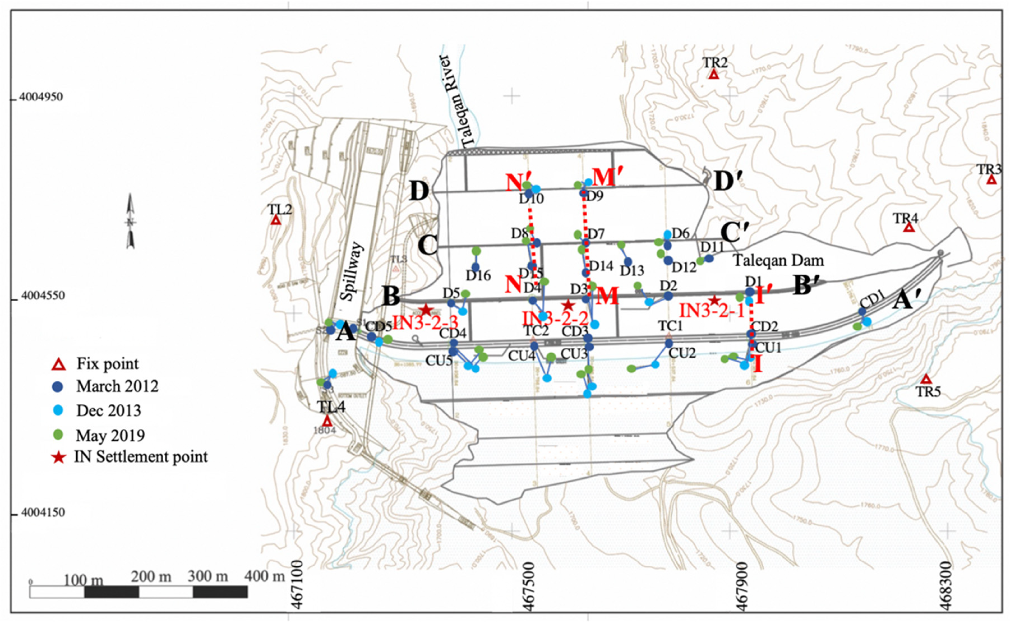
2.2. Field Survey
3. Materials and Methods
3.1. InSAR Analysis
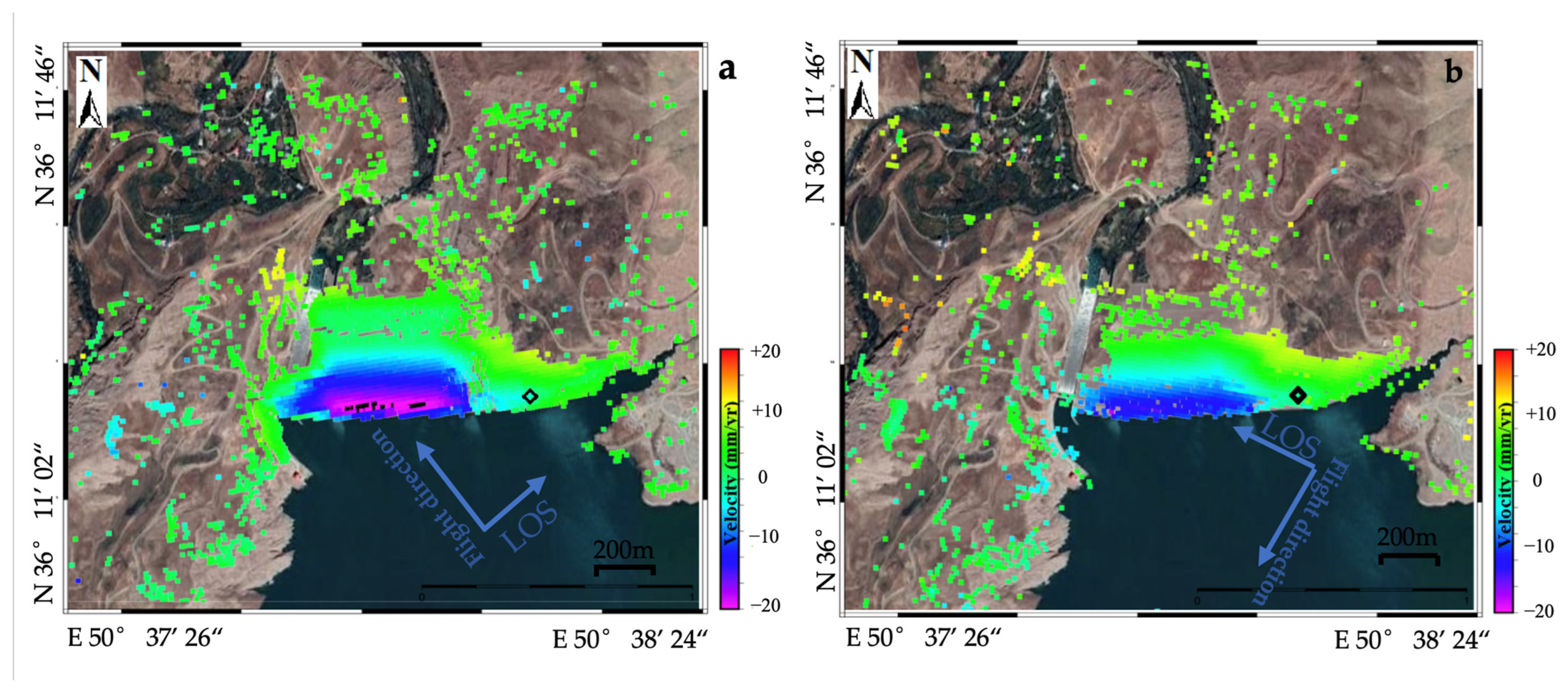
3.1.1. TerraSAR-X Processing
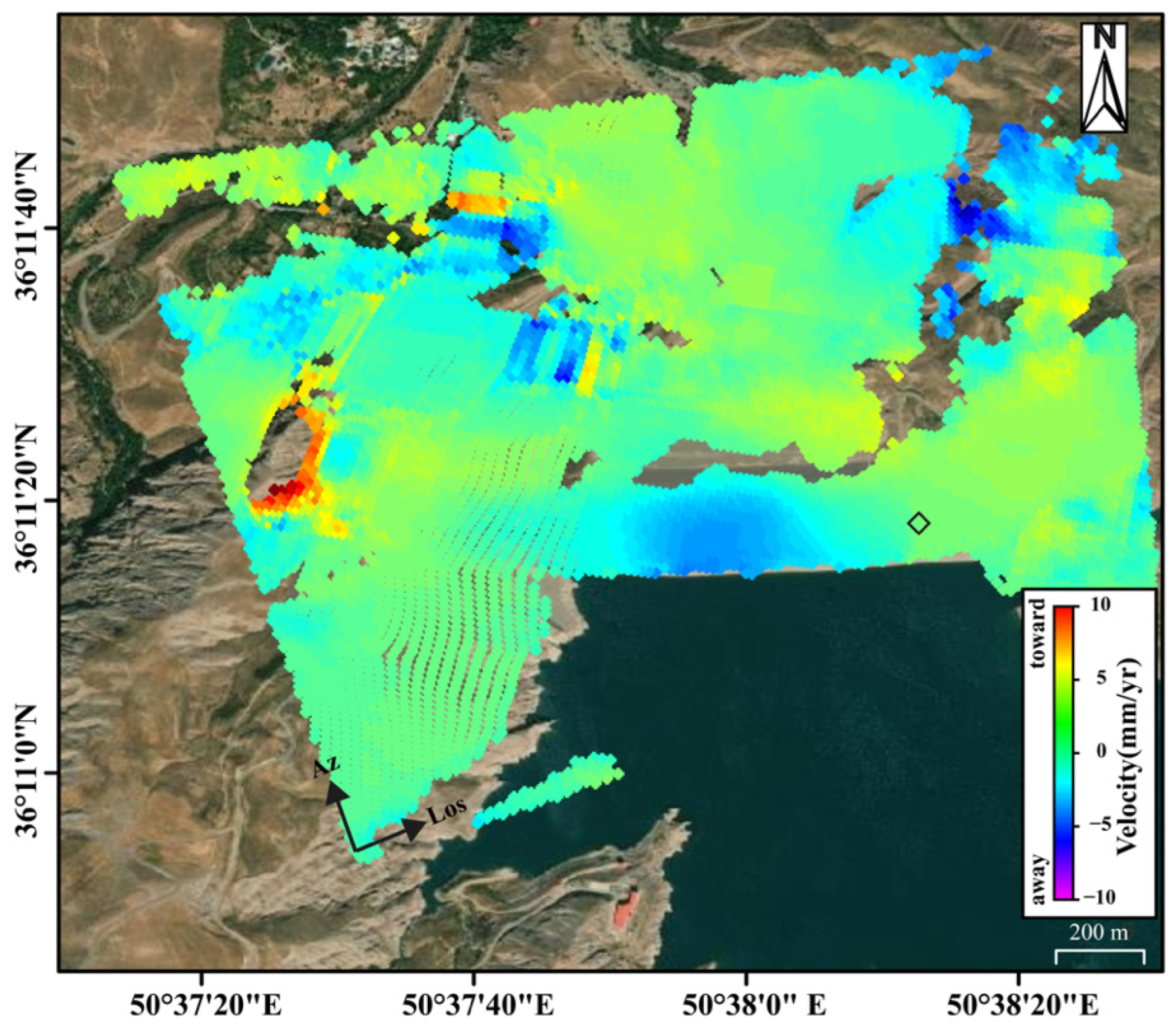
3.1.2. Sentinel-1 Processing
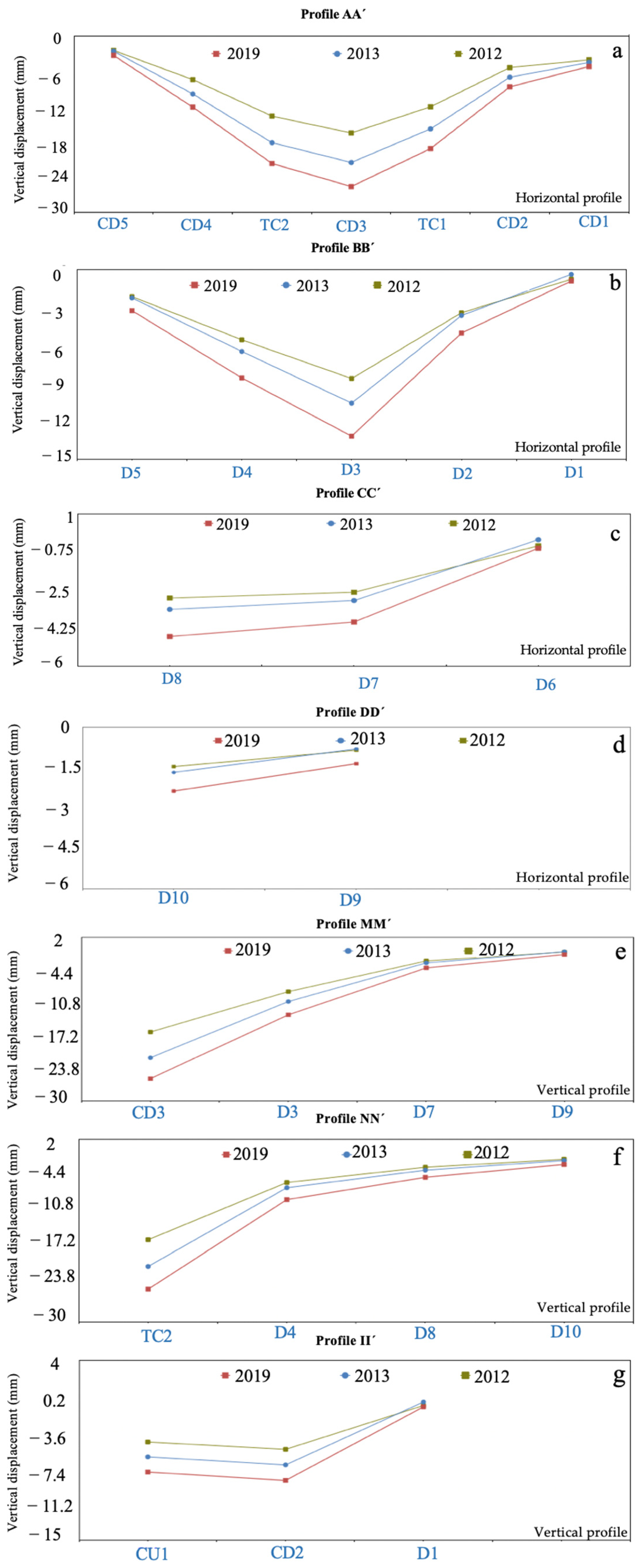
3.2. Geodetic Data
4. Results
4.1. TerraSAR-X Results
4.2. Sentinel-1 Results
4.3. Surveying Measurements
5. Discussion
6. Conclusions
Author Contributions
Funding
Institutional Review Board Statement
Informed Consent Statement
Data Availability Statement
Acknowledgments
Conflicts of Interest
References
- Dascal, O. Postconstruction deformations of rockfill dams. J. Geotech. Eng. 1987, 113, 46–59. [Google Scholar] [CrossRef]
- Clements, R.P. Post-construction deformation of rockfill dams. J. Geotech. Eng. 1984, 110, 821–840. [Google Scholar] [CrossRef]
- Gikas, V.; Sakellariou, M. Settlement analysis of the Mornos earth dam (Greece): Evidence from numerical modeling and geodetic monitoring. Eng. Struct. 2008, 30, 3074–3081. [Google Scholar] [CrossRef]
- Kalkan, Y. Geodetic deformation monitoring of Ataturk Dam in Turkey. Arab. J. Geosci. 2014, 7, 397–405. [Google Scholar] [CrossRef]
- Marchamalo-Sacristán, M.; Ruiz-Armenteros, A.M.; Lamas-Fernández, F.; González-Rodrigo, B.; Martínez-Marín, R.; Delgado-Blasco, J.M.; Bakon, M.; Lazecky, M.; Perissin, D.; Papco, J.; et al. MT-InSAR and Dam Modeling for the Comprehensive Monitoring of an Earth-Fill Dam: The Case of the Benínar Dam (Almería, Spain). Remote Sens. 2023, 15, 2802. [Google Scholar] [CrossRef]
- Ruiz-Armenteros, A.M.; Lazecky, M.; Hlaváčová, I.; Bakoň, M.; Delgado, J.M.; Sousa, J.J.; Lamas-Fernández, F.; Marchamalo, M.; Caro-Cuenca, M.; Papco, J. Deformation monitoring of dam infrastructures via spaceborne MT-InSAR. The case of La Viñuela (Málaga, southern Spain). Procedia Comput. Sci. 2018, 138, 346–353. [Google Scholar] [CrossRef]
- Ghadimi, M.; Nezammahalleh. Ma, Construction of a causeway bridge across the lake Urmia and its influence on drying trend of the lake. Int. Arch. Photogramm. Remote Sens. Spat. Inf. Sci. 2015, 40, 211–213. [Google Scholar] [CrossRef]
- Ghadimi, M.; Kiani; M. Deformation Risk Assessment of the Lar Dam: Monitoring Its Stability Condition. Sustainability 2024, 16, 4335. [Google Scholar] [CrossRef]
- Jansen, R.B. Advanced Dam Engineering for Design, Construction, and Rehabilitation; Springer Science & Business Media: Berlin/Heidelberg, Germany, 1988; ISBN 0442243979. [Google Scholar]
- Guler, G.; Kilic, H.; Hosbas, G.; Ozaydin, K. Evaluation of the movements of the dam embankments by means of geodetic and geotechnical methods. J. Surv. Eng. 2006, 132, 31–39. [Google Scholar] [CrossRef]
- Vázquez-Ontiveros, J.R.; Ruiz-Armenteros, A.M.; de Lacy, M.C.; Gaxiola-Camacho, J.R.; Anaya-Díaz, M.; Vázquez-Becerra, G.E. Risk Evaluation of the Sanalona Earthfill Dam Located in Mexico Using Satellite Geodesy Monitoring and Numerical Modeling. Remote Sens. 2023, 15, 819. [Google Scholar] [CrossRef]
- Stewart, M.; Tsakiri, M. The status of the global positioning system for dam surface monitoring. Proc. Inst. Civ. Eng. Eng. 2001, 149, 249–252. [Google Scholar] [CrossRef]
- Massonnet, D.; Rossi, M.; Carmona, C.; Adragna, F.; Peltzer, G.; Feigl, K.; Rabaute, T. The displacement field of the Landers earthquake mapped by radar interferometry. Nature 1993, 364, 138–142. [Google Scholar] [CrossRef]
- Stramondo, S.; Trasatti, E.; Albano, M.; Moro, M.; Chini, M.; Bignami, C.; Polcari, M.; Saroli, M. Uncovering deformation processes from surface displacements. J. Geodyn. 2016, 102, 58–82. [Google Scholar] [CrossRef]
- Polcari, M.; Montuori, A.; Bignami, C.; Moro, M.; Stramondo, S.; Tolomei, C. Using multi-band InSAR data for detecting local deformation phenomena induced by the 2016–2017 Central Italy seismic sequence. Remote Sens. Environ. 2017, 201, 234–242. [Google Scholar] [CrossRef]
- Zhang, S.; Chen, B.; Gong, H.; Lei, K.; Shi, M.; Zhou, C. Three-Dimensional Surface Displacement of the Eastern Beijing Plain, China, Using Ascending and Descending Sentinel-1A/B Images and Leveling Data. Remote Sens. 2021, 13, 2809. [Google Scholar] [CrossRef]
- Ferretti, A.; Prati, C.; Rocca, F. Permanent scatterers in SAR interferometry. IEEE Trans. Geosci. Remote Sens. 2001, 39, 8–20. [Google Scholar] [CrossRef]
- Hooper, A.; Zebker, H.A. Phase unwrapping in three dimensions with application to InSAR time series. J. Opt. Soc. Am. A 2007, 24, 2737–2747. [Google Scholar] [CrossRef]
- Berardino, P.; Fornaro, G.; Lanari, R.; Sansosti, E. A new algorithm for surface deformation monitoring based on small baseline differential SAR interferograms. IEEE Trans. Geosci. Remote Sens. 2002, 40, 2375–2383. [Google Scholar] [CrossRef]
- Hooper, A. A multi-temporal InSAR method incorporating both persistent scatterer and small baseline approaches. Geophys. Res. Lett. 2008, 35, L16302. [Google Scholar] [CrossRef]
- Casu, F.; Manzo, M.; Lanari, R. A quantitative assessment of the SBAS algorithm performance for surface deformation retrieval from DInSAR data. Remote Sens. Environ. 2006, 102, 195–210. [Google Scholar] [CrossRef]
- Tomás, R.; Cano, M.; Garcia-Barba, J.; Vicente, F.; Herrera, G.; Lopez-Sanchez, J.M.; Mallorquí, J.J. Monitoring an earthfill dam using differential SAR interferometry: La Pedrera dam, Alicante, Spain. Eng. Geol. 2013, 157, 21–32. [Google Scholar] [CrossRef]
- Zhou, W.; Li, S.; Zhou, Z.; Chang, X. Insar observation and numerical modeling of the earth-dam displacement of shuibuya dam (China). Remote Sens. 2016, 8, 877. [Google Scholar] [CrossRef]
- Milillo, P.; Perissin, D.; Salzer, J.T.; Lundgren, P.; Lacava, G.; Milillo, G.; Serio, C. Monitoring dam structural health from space: Insights from novel InSAR techniques and multi-parametric modeling applied to the Pertusillo dam Basilicata, Italy. Int. J. Appl. Earth Obs. Geoinf. 2016, 52, 221–229. [Google Scholar] [CrossRef]
- Di Martire, D.; Iglesias, R.; Monells, D.; Centolanza, G.; Sica, S.; Ramondini, M.; Pagano, L.; Mallorquí, J.J.; Calcaterra, D. Comparison between differential SAR interferometry and ground measurements data in the displacement monitoring of the earth-dam of Conza della Campania (Italy). Remote Sens. Environ. 2014, 148, 58–69. [Google Scholar] [CrossRef]
- Al-Husseinawi, Y.; Li, Z.; Clarke, P.; Edwards, S. Evaluation of the stability of the Darbandikhan Dam after the 12 November 2017 Mw 7.3 Sarpol-e Zahab (Iran–Iraq border) earthquake. Remote Sens. 2018, 10, 1426. [Google Scholar] [CrossRef]
- Neokosmidis, S.; Elias, P.; Parcharidis, I.; Briole, P. Deformation estimation of an earth dam and its relation with local earthquakes, by exploiting multitemporal synthetic aperture radar interferometry: Mornos dam case (Central Greece). J. Appl. Remote Sens. 2016, 10, 26010. [Google Scholar] [CrossRef]
- Honda, K.; Nakanishi, T.; Haraguchi, M.; Mushiake, N.; Iwasaki, T.; Satoh, H.; Kobori, T.; Yamaguchi, Y. Application of exterior deformation monitoring of dams by DInSAR analysis using ALOS PALSAR. In Proceedings of the 2012 IEEE International Geoscience and Remote Sensing Symposium, Munich, Germany, 22–27 July 2012; pp. 6649–6652. [Google Scholar]
- Regional Water Company of Iran, Behaviour Report of the Taleqan Dam; Regional Water Company of Iran location: Sanandaj, Iran, 2016.
- Ghadimi, M. Investigation of riprap stability of a dam: Risk assessment by InSAR method and rock mechanical test. Geomat. Nat. Hazards Risk 2022, 13, 1441–1456. [Google Scholar] [CrossRef]
- SARscape Technical Description. 2012. Available online: http://www.sarmap.ch/pdf/SARscapeTechnical.pdf (accessed on 5 July 2020).
- Hanssen, R.F. Radar Interferometry: Data Interpretation and Error Analysis; Springer Science & Business Media: Berlin/Heidelberg, Germany, 2001; Volume 2, ISBN 0792369459. [Google Scholar]
- Schmidt, D.A.; Bürgmann, R. Time-dependent land uplift and subsidence in the Santa Clara valley, California, from a large interferometric synthetic aperture radar data set. J. Geophys. Res. Solid Earth 2003, 108, 2416. [Google Scholar] [CrossRef]
- Shanker, P.; Zebker, H. Persistent scatterer selection using maximum likelihood estimation. Geophys. Res. Lett. 2007, 34, L22301. [Google Scholar] [CrossRef]
- Hooper, A. A statistical-cost approach to unwrapping the phase of InSAR time series. In Proceedings of the International Workshop on ERS SAR Interferometry, Frascati, Italy, 25–29 January 2010; Volume 30. [Google Scholar]
- Sandwell, D.; Mellors, R.; Tong, X.; Wei, M.; Wessel, P. Open radar interferometry software for mapping surface deformation. Eos 2011, 92, 234. [Google Scholar] [CrossRef]
- Wessel, P.; Smith, W.H.F.; Scharroo, R.; Luis, J.; Wobbe, F. Generic mapping tools: Improved version released. Eos. Trans. Am. Geophys. Union 2013, 94, 409–410. [Google Scholar] [CrossRef]
- Prats-Iraola, P.; Scheiber, R.; Marotti, L.; Wollstadt, S.; Reigber, A. TOPS interferometry with TerraSAR-X. IEEE Trans. Geosci. Remote Sens. 2012, 50, 3179–3188. [Google Scholar] [CrossRef]
- Konakoglu, B.; Cakir, L.; Yilmaz, V. Monitoring the deformation of a concrete dam: A case study on the Deriner Dam, Artvin, Turkey. Geomat. Nat. Hazards Risk 2020, 11, 160–177. [Google Scholar] [CrossRef]
- Bayrak, T. Verifying pressure of water on dams, a case study. Sensors 2008, 8, 5376–5385. [Google Scholar] [CrossRef] [PubMed]
- Gao, M.; Gong, H.; Li, X.; Chen, B.; Zhou, C.; Shi, M.; Guo, L.; Chen, Z.; Ni, Z.; Duan, G. Land subsidence and ground fissures in Beijing capital international airport (bcia): Evidence from quasi-ps insar analysis. Remote Sens. 2019, 11, 1466. [Google Scholar] [CrossRef]
- Fornaro, G.; Pauciullo, A.; Reale, D.; Verde, S. Multilook SAR tomography for 3-D reconstruction and monitoring of single structures applied to COSMO-SKYMED data. IEEE J. Sel. Top. Appl. Earth Obs. Remote Sens. 2014, 7, 2776–2785. [Google Scholar] [CrossRef]
- Wu, S.; Yang, Z.; Ding, X.; Zhang, B.; Zhang, L.; Lu, Z. Two decades of settlement of Hong Kong International Airport measured with multi-temporal InSAR. Remote Sens. Environ. 2020, 248, 111976. [Google Scholar] [CrossRef]
- Wang, Y.; Bai, Z.; Zhang, Y.; Qin, Y.; Lin, Y.; Li, Y.; Shen, W. Using TerraSAR X-band and sentinel-1 C-band SAR interferometry for deformation along Beijing-Tianjin intercity railway analysis. IEEE J. Sel. Top. Appl. Earth Obs. Remote Sens. 2021, 14, 4832–4841. [Google Scholar] [CrossRef]





| Acquisition Date | Orbit | Mode | Resolution (m) | Image Size | Heading Angles | Band | |
|---|---|---|---|---|---|---|---|
| 10 May 2018–17 August 2018 | Ascending | Spotlight | 1 | 10 5 | 34.3 | 350 | X |
| 14 May 2018–10 August 2018 | Descending | Spotlight | 1 | 10 5 | 32.8 | 190 | X |
| Acquisition Date | Orbit | Mode | Resolution (m) | Heading Angles | Band | |
|---|---|---|---|---|---|---|
| 8 October 2014–10 July 2019 | Ascending | (IW) | 20 5 | 32.3 | 350 | C |
| Point Name | (mm) | (mm) | D (mm) | AZ (deg) | A (mm) | B (mm) | X | Y |
|---|---|---|---|---|---|---|---|---|
| D1 | −4.01 | −1.44 | 4.27 | 250 | 1.9 | 1.7 | 50.643399966 | 36.1855455775 |
| D2 | −14.39 | 4.48 | 15.07 | 287 | 2.2 | 1.8 | 50.6417318506 | 36.1855023562 |
| D3 | 1.98 | 7 | 7.28 | 15 | 1.6 | 1.3 | 50.6400768897 | 36.1854595218 |
| D4 | 4.89 | 8.71 | 9.99 | 29 | 2.3 | 1.9 | 50.6372982641 | 36.185385866 |
| D5 | 6.55 | 3.34 | 7.36 | 63 | 1.9 | 1.3 | 50.6372982641 | 36.1853858660 |
| D6 | −2.28 | −0.38 | 2.31 | 260 | 1.9 | 1.6 | 50.6416964584 | 36.1864152025 |
| D7 | −2.79 | 2.9 | 4.02 | 316 | 1.8 | 1.7 | 50.6400398799 | 36.1863724348 |
| D8 | −0.15 | 6.43 | 6.43 | 358 | 1.9 | 1.5 | 50.6389286882 | 36.1863431099 |
| D9 | −1.54 | 1.83 | 2.39 | 320 | 2.0 | 1.9 | 50.6400040829 | 36.1872728855 |
| D10 | −1.69 | 1.86 | 2.51 | 317 | 2.0 | 1.9 | 50.6388923544 | 36.1872438453 |
| CD1 | −1.37 | −5.76 | 5.92 | 193 | 2.0 | 1.7 | 50.6456914611 | 36.1852464386 |
| CD2 | −9.5 | −10.36 | 14.05 | 222 | 1.9 | 1.5 | 50.6434262671 | 36.1848705525 |
| CD3 | −0.73 | −13.85 | 13.87 | 183 | 1.7 | 1.2 | 50.6401036682 | 36.1847838634 |
| CD4 | 14.39 | −6.2 | 15.66 | 113 | 1.6 | 1.4 | 50.6373250966 | 36.1847108890 |
| CD5 | 6.42 | −1.83 | 6.67 | 106 | 1.7 | 1.2 | 50.6357072238 | 36.1848183256 |
| TC1 | −8.7 | 0.59 | 8.72 | 274 | 1.8 | 1.4 | 50.641758891 | 36.1848263772 |
| TC2 | 1.71 | 12.06 | 12.18 | 8 | 1.7 | 1.3 | 50.6389923314 | 36.1847556593 |
Disclaimer/Publisher’s Note: The statements, opinions and data contained in all publications are solely those of the individual author(s) and contributor(s) and not of MDPI and/or the editor(s). MDPI and/or the editor(s) disclaim responsibility for any injury to people or property resulting from any ideas, methods, instructions or products referred to in the content. |
© 2025 by the authors. Licensee MDPI, Basel, Switzerland. This article is an open access article distributed under the terms and conditions of the Creative Commons Attribution (CC BY) license.
Share and Cite
Ghadimi, M.; Hooper, A.; Whipp, D. Deformation of the Taleqan Dam, Iran, from InSAR and Ground Observation. Sustainability 2026, 18, 173. https://doi.org/10.3390/su18010173
Ghadimi M, Hooper A, Whipp D. Deformation of the Taleqan Dam, Iran, from InSAR and Ground Observation. Sustainability. 2026; 18(1):173. https://doi.org/10.3390/su18010173
Chicago/Turabian StyleGhadimi, Mehrnoosh, Andrew Hooper, and David Whipp. 2026. "Deformation of the Taleqan Dam, Iran, from InSAR and Ground Observation" Sustainability 18, no. 1: 173. https://doi.org/10.3390/su18010173
APA StyleGhadimi, M., Hooper, A., & Whipp, D. (2026). Deformation of the Taleqan Dam, Iran, from InSAR and Ground Observation. Sustainability, 18(1), 173. https://doi.org/10.3390/su18010173