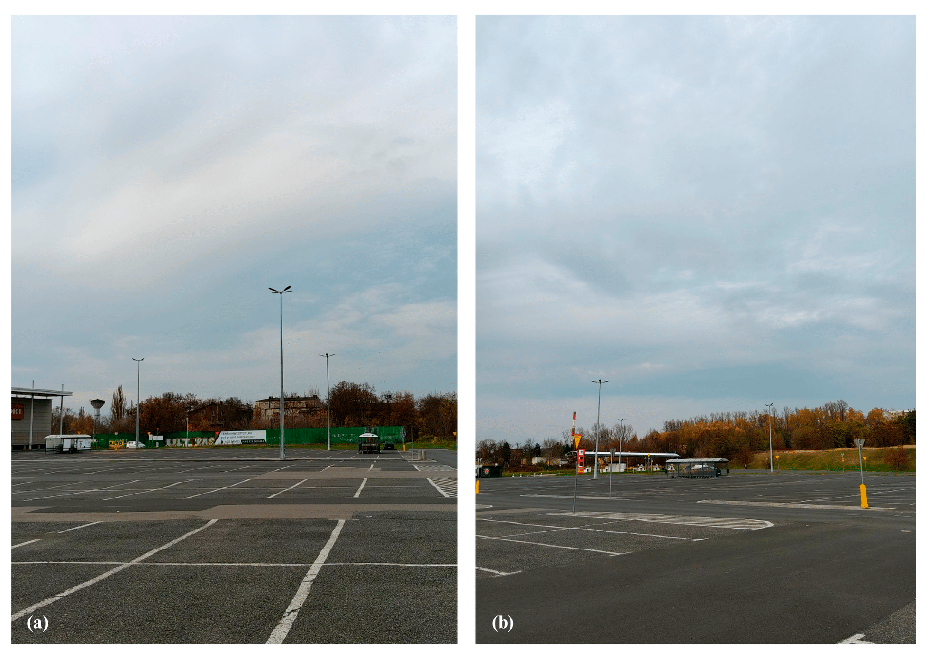
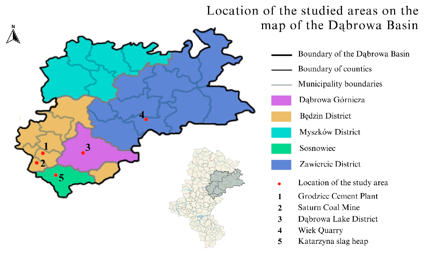
Sustainable Reclamation and Revitalization of Post-Industrial Landscapes: Evidence from the Dąbrowa Basin, Southern Poland



Abstract
1. Introduction
1.1. Research Gap
- Identify and classify the dominant transformation trajectories occurring across post-industrial sites in the region, including hydrological reclamation, heritage-led revitalization, spontaneous ecological succession, commercial redevelopment and unmanaged degradation.
- Assess long-term spatial dynamics (1999–2025) using satellite imagery, historical maps and field observations to document changes in land cover, hydrology, vegetation development and structural preservation.
- Evaluate environmental, functional and cultural conditions using an integrated set of indicators covering landscape quality, ecological integrity, hydrological stability, accessibility and heritage value.
- Compare adaptive readiness across different site types, highlighting opportunities and constraints for sustainable reuse.
- Develop a typology of five transformation models grounded in empirical evidence and aligned with contemporary international frameworks for post-industrial regeneration.
1.2. Aim and Contribution of the Study
- Identify and compare the dominant post-industrial transformation trajectories observed in the region, including hydrological reclamation, heritage-led revitalization, spontaneous ecological succession, commercial redevelopment and unmanaged degradation.
- Assess environmental, functional and cultural outcomes for each site through an integrated evaluation of landscape quality, ecological conditions, hydrological dynamics, accessibility and the preservation of industrial structures.
- Determine the key factors influencing adaptive readiness, including environmental stability, safety, functional diversity, heritage value, governance capacity and community engagement.
- Classify and refine transformation models that represent the main pathways of sustainable post-industrial redevelopment in the Dąbrowa Basin and comparable regions.
- Situate regional developments within broader European and global frameworks, comparing the region’s trajectories with international examples of post-industrial landscape management, including those from the Ruhrgebiet, Upper Silesia, Wallonia, the Ostrava–Karviná Basin and the Lusatian Lake District.
2. Materials and Methods
2.1. Research Framework and Initial Inventory
- Industrial origin;
- Period of activity;
- Remaining structures;
- Availability of archival information.
- Google Earth Pro (v. 7.3.6)—multi-temporal satellite imagery (2003, 2009, 2020, 2025);
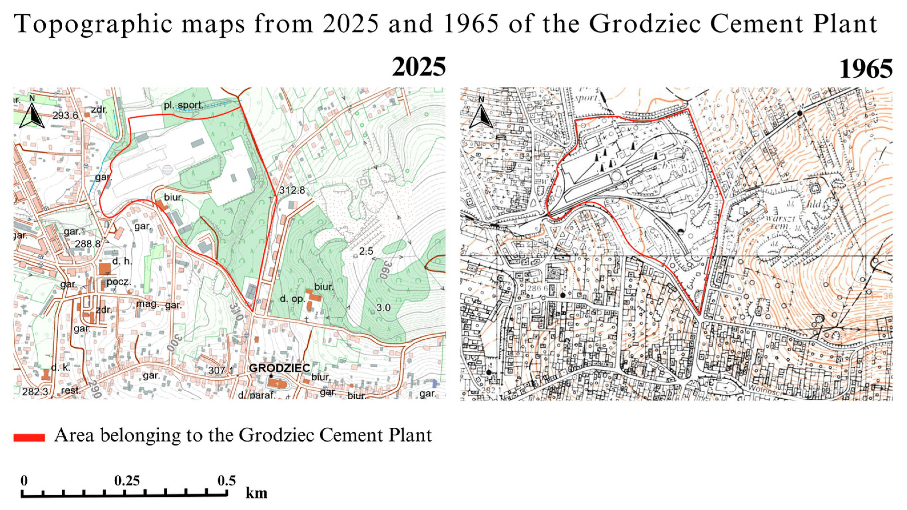
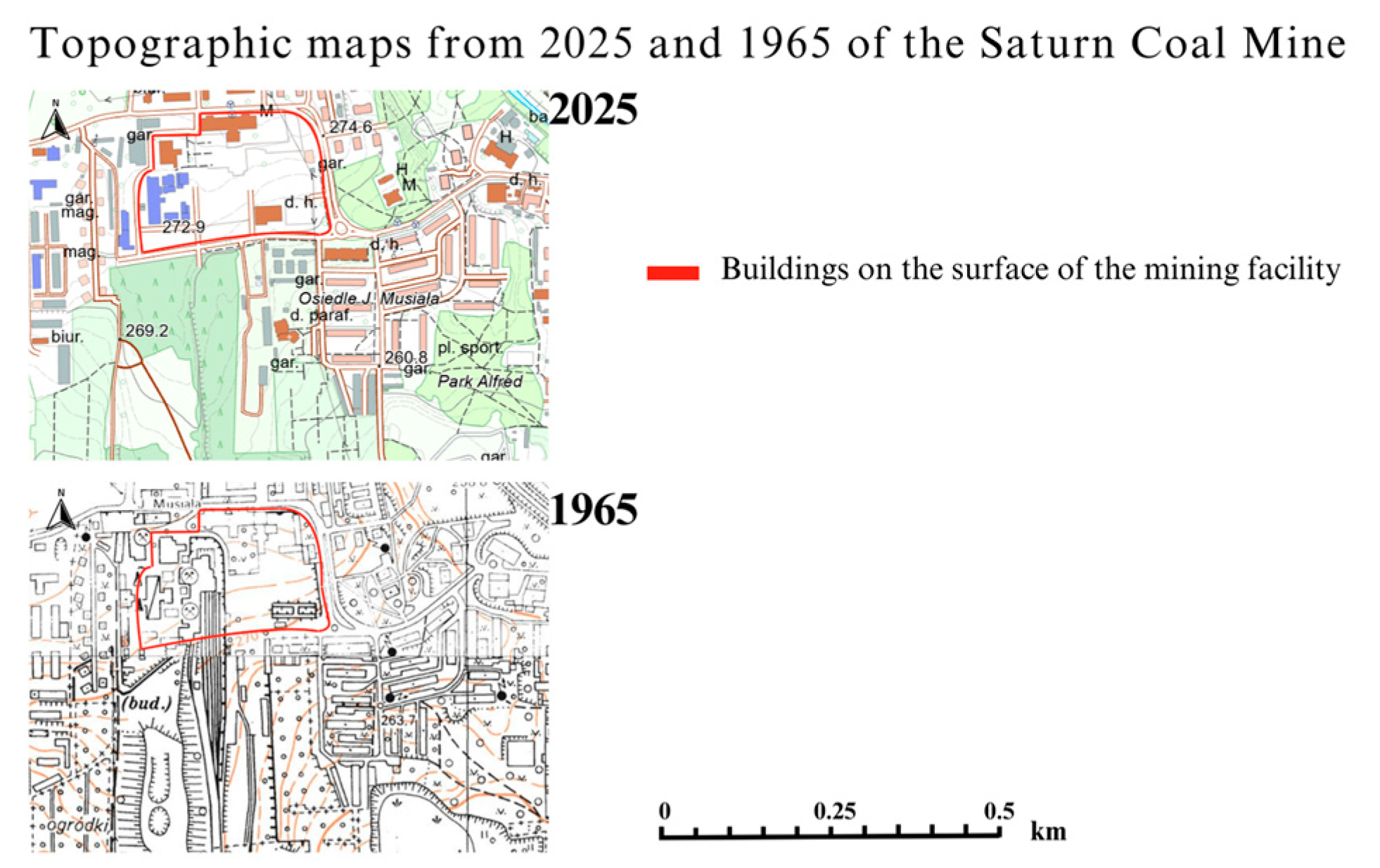
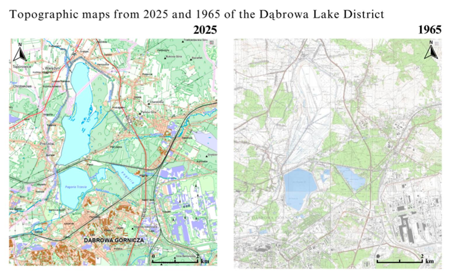
- Geoportal.gov.pl—layers topographic maps (1965, 2025);
- Digitised pre-war maps (1936) from the Digital Repository of Scientific Institutes (RCIN);
- Cadastral data;
- Local and regional press archives (2000–2025).
- Documented industrial activity;
- Detectable landscape or structural change within the last 20–25 years;
- Availability of historical and contemporary imagery;
- Physical accessibility for field assessment.
- (a)
- Imagery was incomplete;
- (b)
- Access was restricted;
- (c)
- No measurable transformation occurred after closure;
- (d)
- The site lacked relevance to the study’s analytical framework.
2.2. Literature and Regional Press Analysis
- Reclamation approaches;
- Ecological and hydrological restoration;
- Industrial heritage management;
- Socio-environmental transitions;
- Regional planning frameworks in Central Europe.
- Public perceptions and conflicts;
- Redevelopment decisions;
- Safety issues and accidents;
- Community initiatives;
- Municipal involvement and investment patterns.
2.3. Analysis of Historical and Contemporary Spatial Data
- (1)
- Pre-war topographic maps (1936; used selectively)
- (2)
- Mid-20th-century topographic map (1965)
- Extraction pits.
- Industrial buildings.
- Transport infrastructure.
- Spoil heaps.
- (3)
- Contemporary cartographic data (2025)
- Land-use categories.
- Hydrological structures.
- Settlement patterns.
- Recreational infrastructure.
- Vegetation distribution.
- Preserved or demolished industrial elements.
2.4. Google Earth Pro Analysis
2.4.1. Temporal Analysis Protocol
- Identical viewing frame (bounding box locked for each site).
- Identical camera angle and scale for all time points.
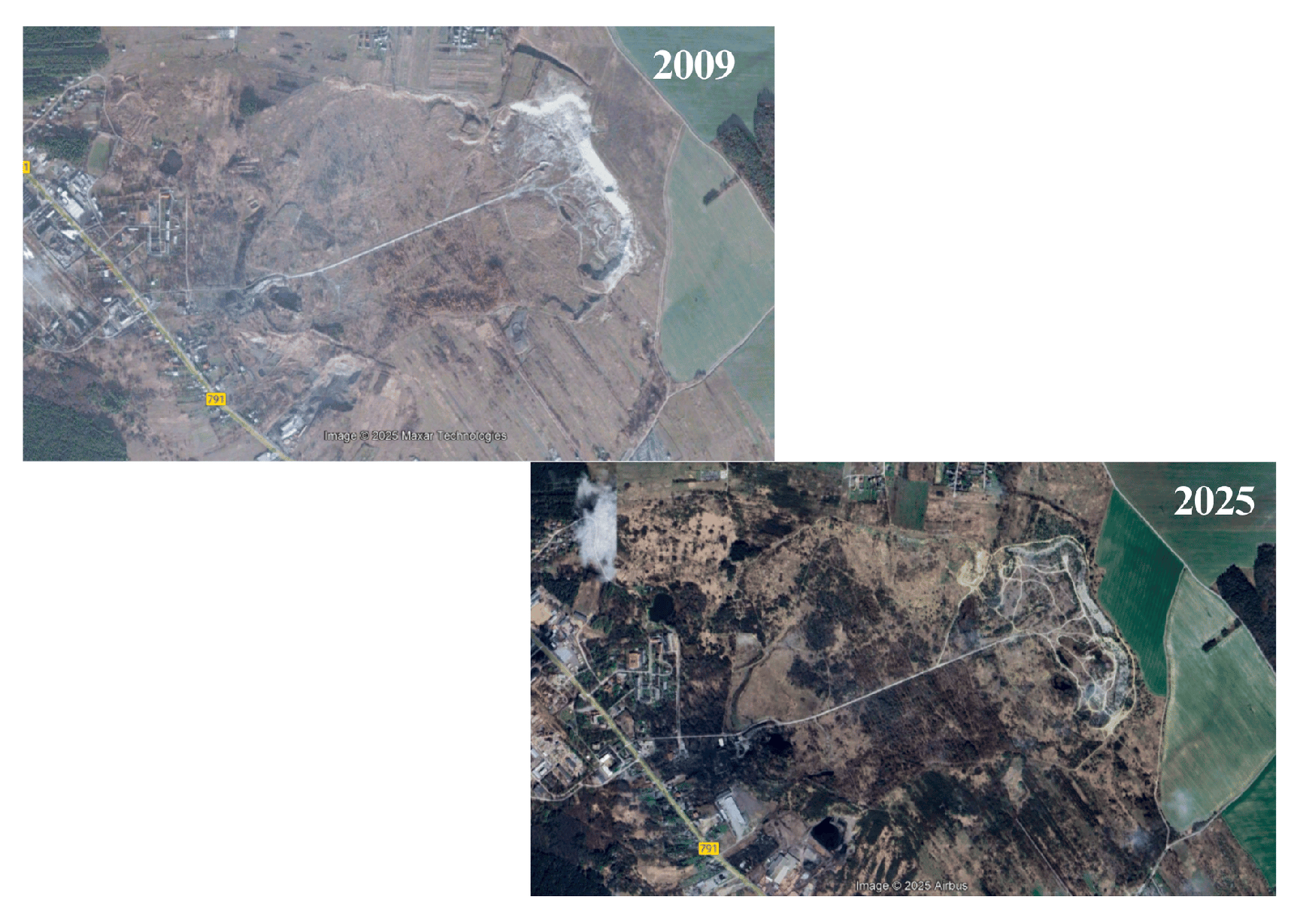
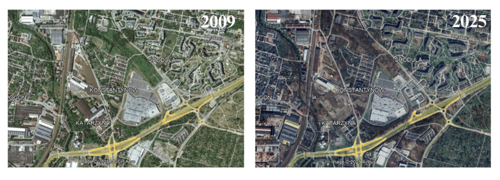
- Consistent time intervals: every available year was examined; key transition years were extracted for documentation.
- Visual interpretation of
- -
- Vegetation dynamics;
- -
- Structural demolition;
- -
- Progressive exposure or infilling of pits;
- -
- Shoreline development;
- -
- Informal access paths;
- -
- Regeneration patterns.
2.4.2. Quantitative Measurements
- Polygon tool was used to delineate and calculate the area of extraction pits, flooded basins, forests, spoil heaps and built-up zones.
- Path/Ruler tools supported measurement of shoreline changes, expansion of vegetation patches, removal of spoil heaps and development of road/path networks.
- All measurements were recorded in WGS84 (default GEP coordinate system).
2.4.3. Interpretive Accuracy and Cross-Validation
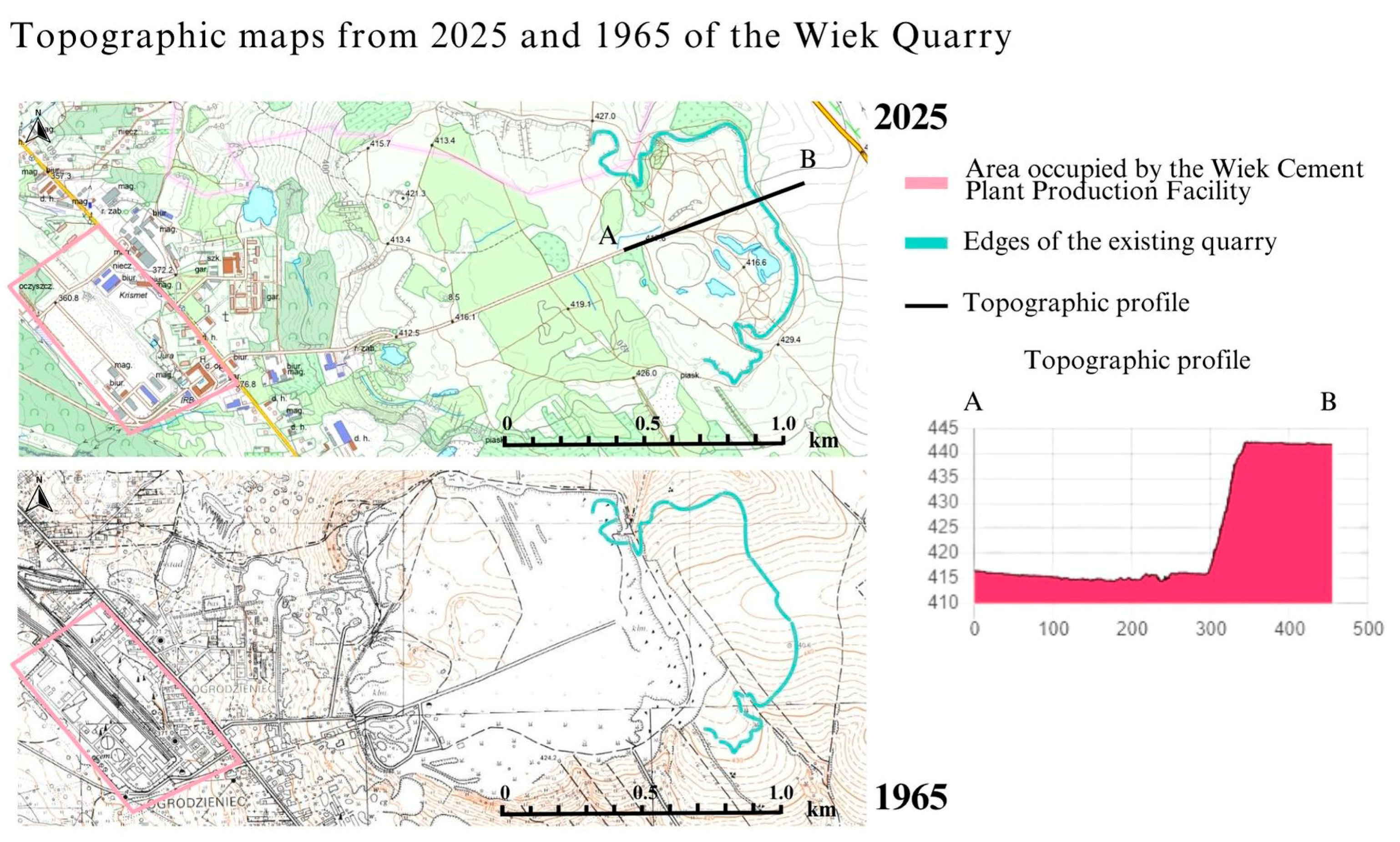
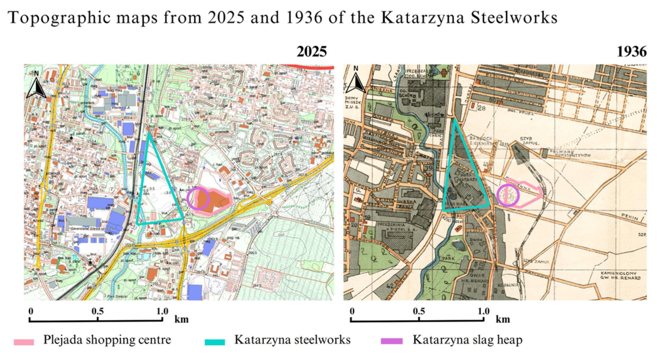
- Historical topographic maps (1936, 1965);
- 2025 topographic maps;
- Orthophotos;
- Field surveys (2023–2024);
- Regional press descriptions (2000–2025).
2.5. Field Surveys
- Safety: slope stability, hazardous structures, unsecured quarry edges, unsafe voids.
- Maintenance & monitoring: fences, cameras, lighting, signage.
- Industrial heritage: buildings, shafts, foundations, machinery, markers.
- Environmental quality: waste accumulation, vegetation health, erosion, scenic value.
- Vegetation structure: managed vs. unmanaged; succession stage (I–III).
- Accessibility: entrances, footpaths, public transport, barriers.
- Cultural presence: murals, events, commemorations, local narratives.
- Municipal involvement: recent investments, renovation works, evidence of ongoing management.
2.6. Data Synthesis and Site Selection Criteria
3. Results
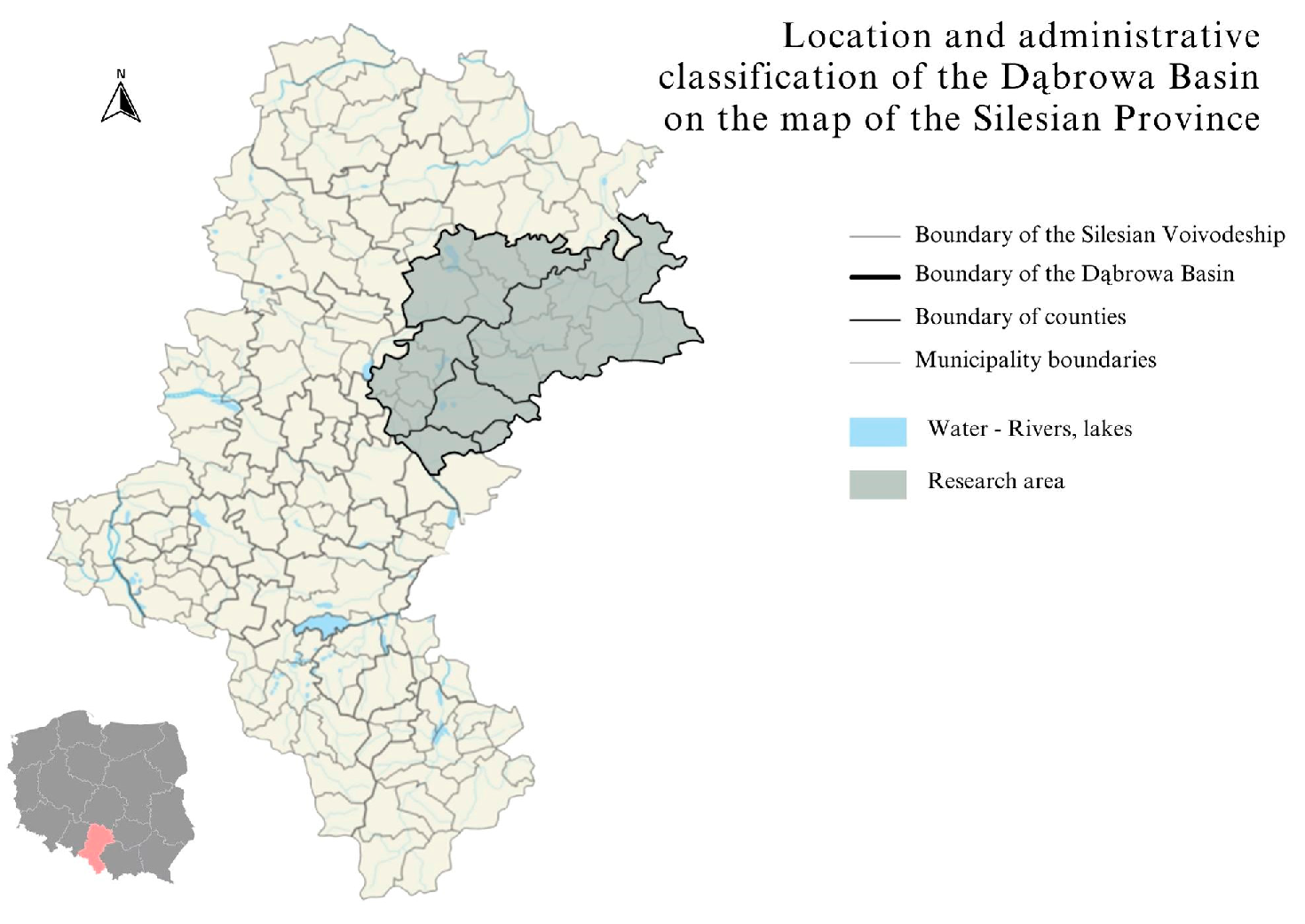
3.1. General Characteristics of the Study Area
- Infilling and flooding of extraction pits;
- Spontaneous afforestation of abandoned quarries and spoil heaps;
- Partial or complete demolition of industrial buildings;
- Redevelopment of former industrial zones into commercial or recreational areas;
- The emergence of unmanaged vegetation and informal uses in neglected locations.
3.2. Multi-Criteria Assessment (MCA) Scoring
- The highest scores were recorded for Saturn (16/16) and the Dąbrowa Lake District (14/16).
- Katarzyna Slag Heap reached high readiness (12/16).
- Wiek Quarry showed intermediate conditions (5/16).
- Grodziec Cement Plant scored the lowest (2/16).
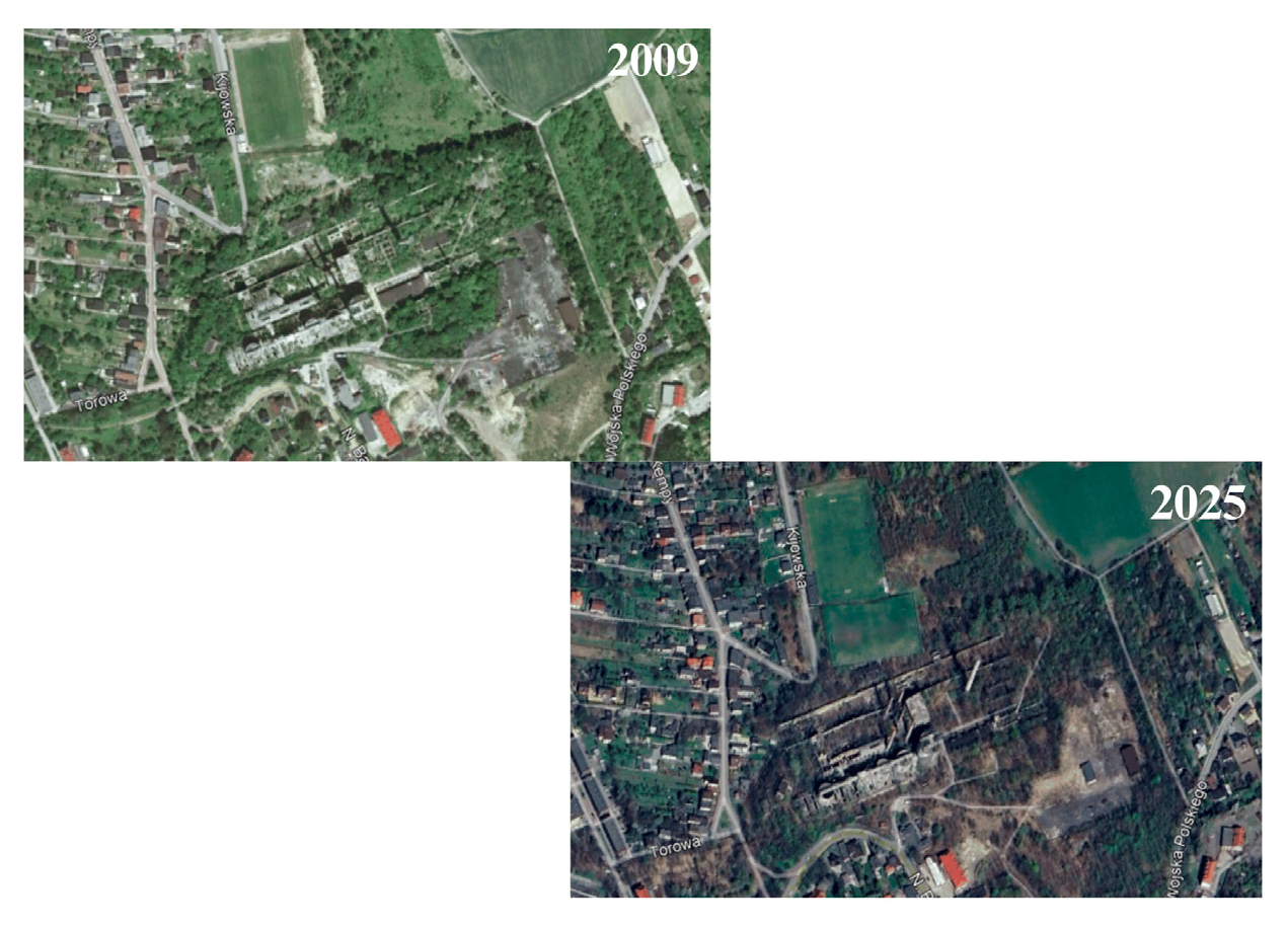
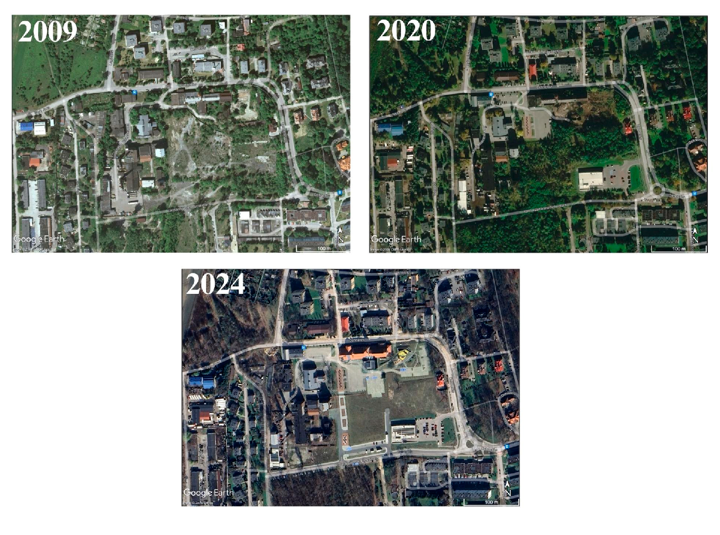
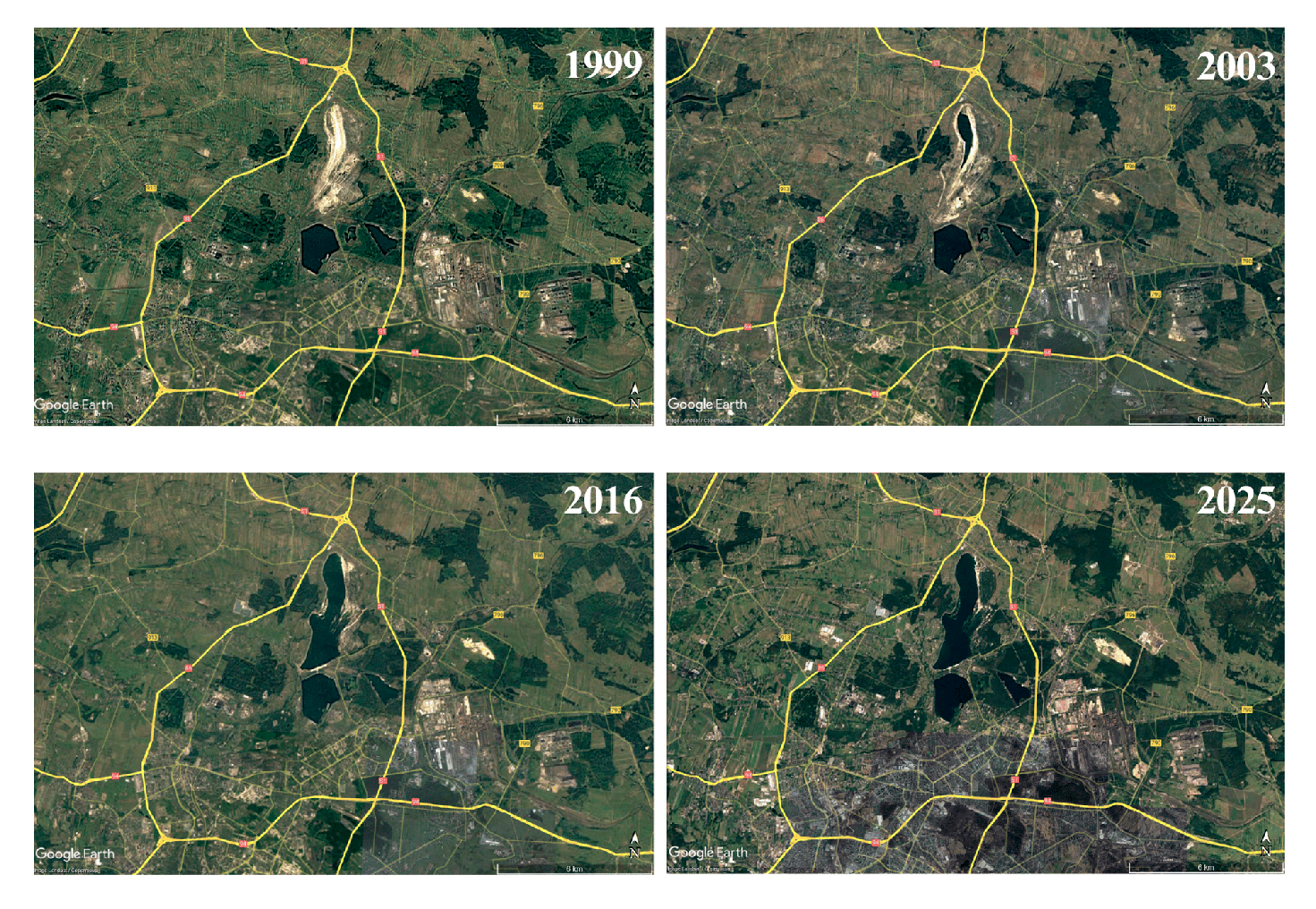
3.3. Multi-Temporal Spatial Changes (1999–2025)
3.4. Environmental and Functional Assessment of the Five Sites
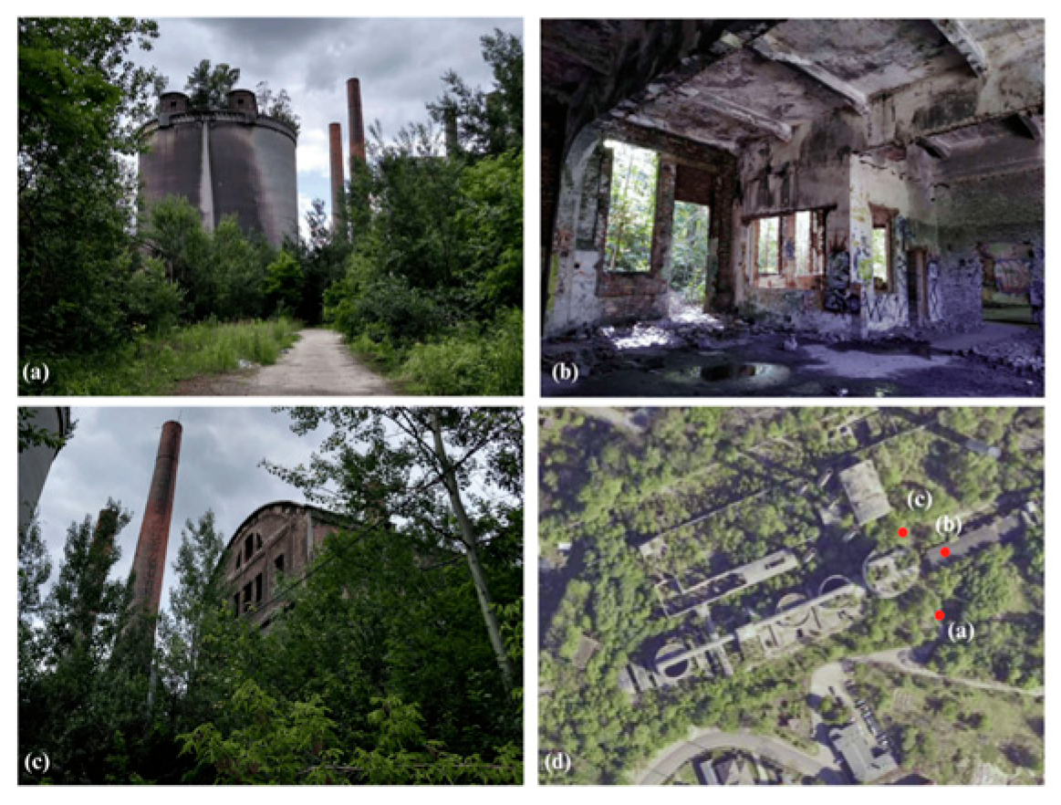
3.4.1. Grodziec Cement Plant
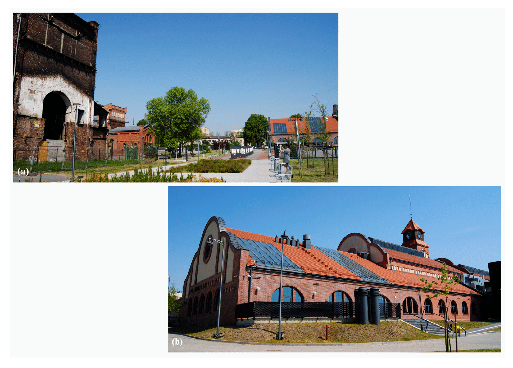
3.4.2. Saturn Coal Mine
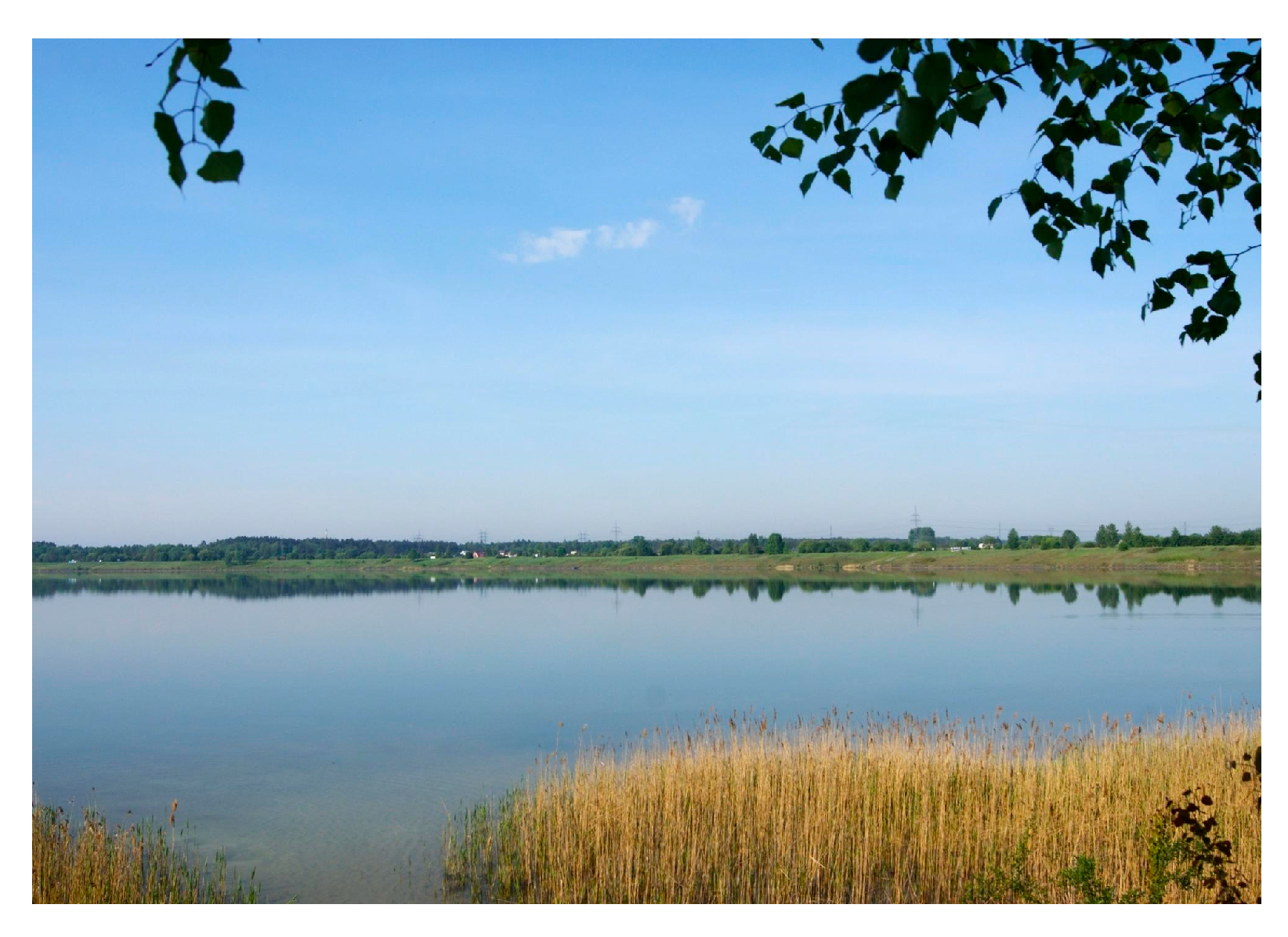
3.4.3. Dąbrowa Lake District (Pogoria I–III, Kuźnica Warężyńska)
3.4.4. Wiek Quarry
3.4.5. Katarzyna Slag Heap
3.5. Comparative Evaluation of the Sites
- Highest adaptive readiness (10–16 occurs in sites where environmental restoration has been combined with cultural or recreational functions (Saturn, Dąbrowa Lake District, Katarzyna slag heap). These sites show strong municipal engagement, high accessibility, and well-maintained infrastructure.
- Intermediate readiness is associated with sites undergoing either passive natural succession (Wiek Quarry) or economic redevelopment (Katarzyna Slag Heap). These transformations stabilize the terrain but provide limited cultural or ecological benefits.
- Lowest readiness is characteristic of unmanaged and degraded sites that have not undergone revitalization (Grodziec Cement Plant). These areas present safety issues, low visual quality, and minimal functional value.
3.6. Synthesis of Results
- Hydrological reclamation (Pogoria system).
- Cultural and heritage revitalization (Saturn Coal Mine).
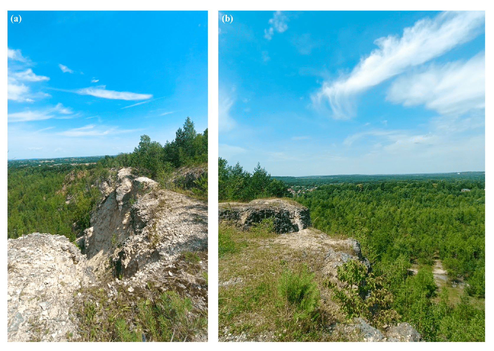
- Passive ecological succession (Wiek Quarry).
- Economic redevelopment (Katarzyna Slag Heap).
4. Discussion
4.1. Regional Patterns of Post-Industrial Transformation
4.2. Comparison with International Frameworks
4.3. Governance, Funding and Local Context
4.4. Methodological Reflections
4.5. Synthesis of Transformation Models
- Hydrological reclamation;
- Cultural–architectural revitalization;
- Passive natural succession;
- Economic redevelopment;
- Unmanaged degradation.
4.6. Study Limitations
5. Conclusions
Author Contributions
Funding
Institutional Review Board Statement
Informed Consent Statement
Data Availability Statement
Conflicts of Interest
References
- Festin, E.S.; Tigabu, M.; Chileshe, M.N.; Syampungani, S.; Odén, P.C. Progresses in restoration of post-mining landscape in Africa. J. For. Res. 2019, 30, 381–396. [Google Scholar] [CrossRef] [Scilit]
- Sobol, A. Circular economy in sustainable development of cities. Econ. Environ. 2019, 71, 12. [Google Scholar]
- Wirth, P.; Mali, B.; Fischer, W. Post-Mining Regions in Central Europe: Problems, Potentials, Possibilities; Oekom Verlag: Munich, Germany, 2012. [Google Scholar]
- Pasqualetti, M.J.; Frantál, B. The evolving energy landscapes of coal: Windows on the past and influences on the future. Morav. Geogr. Rep. 2022, 30, 228–236. [Google Scholar] [CrossRef] [Scilit]
- European Commission. Updating the 2020 Industrial Strategy; EC: Brussels, Belgium, 2021. [Google Scholar]
- Németh, J.; Langhorst, J. Rethinking urban transformation: Temporary uses for vacant land. Cities 2014, 40, 143–150. [Google Scholar] [CrossRef] [Scilit]
- Bagaeen, S. Redeveloping former military sites: Competitiveness, urban sustainability and public participation. Cities 2006, 23, 339–352. [Google Scholar] [CrossRef] [Scilit]
- Daineko, L.; Karavaeva, N.; Yurasova, I. Redevelopment of ex-industrial areas in Yekaterinburg. IOP Conf. Ser. Mater. Sci. Eng. 2021, 1079, 032093. [Google Scholar] [CrossRef] [Scilit]
- Kurtović, S.; Siljković, B.; Pavlović, N. Methods of identification and evaluation of brownfield sites. Int. J. Res. Bus. Soc. Sci. 2014, 3, 60–74. [Google Scholar] [CrossRef] [Scilit]
- Wolff, M.; Haase, D.; Priess, J.; Hoffmann, T.L. The role of brownfields and their revitalization for the functional connectivity of the urban tree system in a regrowing city. Land 2023, 12, 333. [Google Scholar] [CrossRef] [Scilit]
- Kantor-Pietraga, I.; Zdyrko-Bednarczyk, A.; Bednarczyk, J. Importance of Blue–Green Infrastructure in the Spatial Development of Post-Industrial and Post-Mining Areas: The Case of Piekary Śląskie, Poland. Land 2025, 14, 918. [Google Scholar] [CrossRef] [Scilit]
- Yang, Y.; Hakimi, H.A.; Azmi, N.F.; Li, K.; Duan, B. A Framework for Heritage-Led Regeneration in Chinese Traditional Villages: Systematic Literature Review and Experts’ Interview. Heritage 2025, 8, 219. [Google Scholar] [CrossRef] [Scilit]
- Jianjun, D. Revitalization of Old Revolutionary Base Areas: Challenges, Opportunities and Pathways—Based on a 5D analytical framework. China Econ. 2024, 19, 55–84. [Google Scholar] [CrossRef]
- Yang, Z.; Liu, T.; Shen, N.; Guan, M.; Zheng, Y.; Jiang, H. Resource and Environment Constraints and Promotion Strategies of Rural Vitality: An Empirical Analysis of Rural Revitalization Model Towns. Front. Environ. Sci. 2022, 10, 956644. [Google Scholar] [CrossRef] [Scilit]
- Gaćina, R.; Bajić, S.; Dimitrijević, B.; Šubaranović, T.; Beljić, Č.; Bajić, D. Application of the VIKOR Method for Selecting the Purpose of Recultivated Terrain after the End of Coal Mining. C. R. Acad. Bulg. Sci. 2024, 77, 1031–1041. [Google Scholar] [CrossRef] [Scilit]
- Hong, L.; Feng, S.; Li, P.; Wang, A. Ecological Restoration and Regeneration Strategies for the Gumi Mountain Mining Area in Wuhan Guided by Nature-Based Solution (NbS) Concepts. Sustainability 2025, 17, 1913. [Google Scholar] [CrossRef] [Scilit]
- Catur, D.; Arifin, A. Environmental Rehabilitation of Industrial Area Challenges and Solutions Toward a Green Economy. KnE Soc. Sci. 2025, 10, 215–222. [Google Scholar] [CrossRef] [Scilit]
- Pampus, M. Life in the ruins of a post-mining landscape: The co-constitutive character of human and non-human action in land restoration. Swed. J. Anthropol. 2024, 7, 81–100. [Google Scholar] [CrossRef] [Scilit]
- Gyurkovich, J. Recipe for a New Life in Post-Industrial Areas. J. Herit. Conserv. 2022, 69, 64–71. [Google Scholar]
- Kostenko, T.; Bohomaz, O.; Hlushko, I.; Liashok, N. Use of solid mining waste to improve water retention capacity of loamy soils. Min. Miner. Depos. 2023, 17, 29–34. [Google Scholar] [CrossRef] [Scilit]
- Krodkiewska, M.; Łozowski, B.; Sierka, E.; Nadgórska-Socha, A.; Woźnica, A.; Feist, B.; Babczyńska, A. Artificial Water Bodies in Post-Industrial and Urban Landscapes—A Case Study on Assessing Their Potential in Blue–Green Urban Infrastructure. Water 2025, 17, 2862. [Google Scholar] [CrossRef] [Scilit]
- Popovych, V.; Skrobala, V.; Tyndyk, O.; Kaspruk, O. Hydro-ecological monitoring of heavy metal pollution of water bodies in the Western Bug River basin within the mining-industrial region. Min. Miner. Depos. 2024, 18, 139–150. [Google Scholar] [CrossRef] [Scilit]
- France, R.; Braiden, H. Restorative Experiences of Regenerative Environments: Landscape Phenomenology and the Transformation of Post-Industrial Spaces into Re-Naturalized Public Places. Environ. Soc. 2024, 15, 234–251. [Google Scholar] [CrossRef] [Scilit]
- Faramarzi, H.; Khakzand, M. Eco-Revelatory: The Missing Link in the Development of Adaptive Landscape to Industrial Heritage Sites. Herit. Soc. 2024, 1–22. [Google Scholar] [CrossRef] [Scilit]
- Szewczyk-Świątek, A. Sustainable Transformation of Post-Mining Areas: Discreet Alliance of Stakeholders in Influencing the Public Perception of Heavy Industry in Germany and Poland. Sustainability 2025, 17, 8567. [Google Scholar] [CrossRef] [Scilit]
- Wirth, T.M.; Heuschkel, Z.; Dorn, C.; Stabel, A.A.; Lohrberg, F. From Mining–Recultivation Towards Urban Agriculture Strategies: Learning from Informal Planning with Thematic Focus in the Rhenish Mining Area. In Productive Processes: Sustainable Transitions for Urban Industrial Lands = Produktive Prozesse: Nachhaltiger Wandel Urbaner Gewerbegebiete; Chang, R.A., Förster, A., Gärtner, S., Kohlhas, L., Eds.; RWTH Aachen University: Aachen, Germany, 2023; pp. 165–182. [Google Scholar] [CrossRef]
- Klute, J.; Kenway, P. Structural Change and Industrial Politics in the Ruhr Region; Rosa-Luxemburg-Stiftung: Berlin, Germany, 2023; Available online: https://www.rosalux.de/fileadmin/rls_uploads/pdfs/engl/9-23_Onl-Publ_Structural_Change.pdf (accessed on 24 October 2025).
- Popelková, R.; Mulková, M. The mining landscape of the Ostrava–Karviná coalfield: Processes of landscape change 1830s–21st century. Appl. Geogr. 2018, 90, 28–43. [Google Scholar] [CrossRef] [Scilit]
- Pepe, L.; Schmitz, S. The sense of place of local mining heritage in Wallonia. Herit. Soc. 2023, 1–33. [Google Scholar] [CrossRef] [Scilit]
- Czerwińska, K. About Coal Differently: A Reinterpretation of the Post-Industrial Heritage of Upper Silesia in the Context of Socially Engaged Design. In Silesia Superior: Narratives on Upper Silesia–The Multitude of Perspectives; Dampc-Jarosz, R., Kowalczyk, A., Sadzikowska, L., Eds.; V&R Unipress: Göttingen, Germany, 2024; pp. 115–134. [Google Scholar]
- Guerin, F.; Szcześniak, M. (Eds.) Visual Culture of Post-Industrial Europe; Amsterdam University Press: Amsterdam, The Netherlands, 2024. [Google Scholar] [CrossRef] [Scilit]
- Li, Q.; Hu, Y. The Construction of Cultural Gene Map and Revitalization Strategies for Industrial Heritage: A Case Study of Hanyang Ironworks in Wuhan. MAJ Malays. Archit. J. 2025, 7, 176–192. [Google Scholar]
- Toura, V. Rethinking Creativity at Neighborhood Level in the Post-Industrial ERA. The case studies of two urban voids redevelopments in France: Ile-de-Nantes and Docks-de-Seine. In Proceedings of the Grand Projects–Urban Legacies of the late 20th Century, Lisbon, Portugal, 17–19 February 2021. [Google Scholar]
- Hajduková, R.; Sopirová, A. Typology of Terrain Vague and Emergence Mechanisms in Post-Communist, Post-Industrial Small and Medium-Sized Towns in Slovakia: Case Study of Humenné, Strážske and Vranov and Topľou. ALFA Archit. Pap. Fac. Archit. Des. 2023, 28, 21–29. [Google Scholar] [CrossRef] [Scilit]
- Gerwin, W.; Raab, T.; Birkhofer, K.; Hinz, C.; Letmathe, P.; Leuchner, M.; Roß-Nickoll, M.; Rüde, T.; Trachte, K.; Wätzold, F.; et al. Perspectives of lignite post-mining landscapes under changing environmental conditions: What can we learn from a comparison between the Rhenish and Lusatian region in Germany? Environ. Sci. Eur. 2023, 35, 36. [Google Scholar] [CrossRef] [Scilit]
- Major, V.; Svarcova, V.; Hendrychova, M.; Vondrakova, L. Water quality of reclaimed lakes in post-mining locations of Czech Republic. Environ. Monit. Assess. 2025, 197, 1073. [Google Scholar] [CrossRef] [Scilit] [PubMed]
- Kuzior, A.; Grebski, W.; Kwilinski, A.; Krawczyk, D.; Grebski, M.E. Revitalization of Post-Industrial Facilities in Economic and Socio-Cultural Perspectives—A Comparative Study between Poland and the USA. Sustainability 2022, 14, 11011. [Google Scholar] [CrossRef] [Scilit]
- Dylong, K. Rewitalizacja terenów pokopalnianych w Zagłębiu Dąbrowskim. Builder 2024, 327, 2–5. [Google Scholar] [CrossRef] [Scilit]
- Starostwo, B. Zabytkowa Cementownia Grodziec. Available online: https://starostwo.bedzin.pl/ (accessed on 24 October 2025).
- Lipiński, R. Cementownia Grodziec. Available online: https://Blog.Architekt.Bedzin.Pl/Cementownia-Grodziec (accessed on 24 October 2025).
- Sobierajski, P. Zabytkowa Cementownia Grodziec W Będzinie Uratowana. Miasto Dostało Rekordowe 72 Mln Zł Dofinansowania Na Ogromny Projekt. Available online: https://Dziennikzachodni.Pl/Zabytkowa-Cementownia-Grodziec-W-Bedzinie-Uratowana-Miasto-Dostalo-Rekordowe-72-Mln-Zl-Dofinansowania-Na-Ogromny-Projekt/Ar/C3-18942663 (accessed on 24 October 2025).
- Historia w Sieci—Saturn. Available online: https://Muzeum-Saturn.Czeladz.Pl/Historia-W-Sieci-Saturn/ (accessed on 9 May 2024).
- Babak, M. Czeladź Zrewitalizowała Cechownię Dawnej Kopalni Saturn. Available online: https://Dzieje.Pl/Dziedzictwo-Kulturowe/Czeladz-Zrewitalizowala-Cechownie-Dawnej-Kopalni-Saturn (accessed on 9 May 2024).
- Sobierajski, P. W Czeladzi Powstaje Pierwszy, Kryty Miejski Basen. Pływalnia Na Terenie Byłej Kopalni Saturn Z Historyczną, Unikatową Architekturą. Available online: https://Bedzin.Naszemiasto.Pl/W-Czeladzi-Powstaje-Pierwszy-Kryty-Miejski-Basen-Plywalnia-Na-Terenie-Bylej-Kopalni-Saturn-Z-Historyczna-Unikatowa-Architektura/Ar/C1p2-27341897 (accessed on 24 October 2025).
- Sobierajski, P. Kopalnia Saturn W Czeladzi Fedrowała Ponad 100 Lat. Takich Zdjęć Z Jej Wnętrza Jeszcze Nie Widzieliście. ‘Będą Pamiątką’. Available online: https://dziennikzachodni.pl/kopalnia-saturn-w-czeladzi-fedrowala-ponad-100-lat-takich-zdjec-z-jej-wnetrza-jeszcze-nie-widzieliscie-beda-pamiatka/ar/c1p2-27402895 (accessed on 24 October 2025).
- Panusch, P. Kopalnia Saturn I Gsw Elektrownia. Available online: https://Www.Poznajhistorie.Pl/Monument/Czeladz-Kopalniasaturn (accessed on 9 May 2024).
- Jaguś, A.; Rzętała, M. Znaczenie Zbiorników Wodnych W Kształtowaniu Krajobrazu (Na Przykładzie Kaskady Jezior Pogorii); Wydawnictwo Naukowe Akademii Techniczno-Humanistycznej w Bielsku-Białej: Bielsko-Biała, Poland, 2008. [Google Scholar]
- Jeziora Pogoria. Available online: https://Www.Slaskie.Travel/Poi/3800/Zespol-Sztucznych-Zbiornikow-Wodnych-Pogoria-I-Iii (accessed on 9 May 2024).
- Pogoria II-Dzikie Oblicze Pojezierz. Available online: https://www.dabrowa-gornicza.pl/aktualnosci/pogoria-ii-dzikie-oblicze-pojezierza/#:~:text=Pogoria%20II%2C%20spo%C5%9Br%C3%B3d%20wszystkich%20zbiornik%C3%B3w%20tzw.%20pojezierza%20d%C4%85browskiego%2C,si%C4%99%20siedliskiem%20wielu%20gatunk%C3%B3w%20ryb%2C%20ptak%C3%B3w%20i%20ro%C5%9Blin (accessed on 24 October 2025).
- Machowski, R.; Rzętała, M. Zbiornik Pogoria III. Available online: https://Ibrbs.Pl/Index.Php/Zbiornik_Pogoria_III (accessed on 9 May 2024).
- Machowski, R. Zbiornik Pogoria I. Available online: https://Ibrbs.Pl/Index.Php/Zbiornik_Pogoria_I (accessed on 9 May 2024).
- Mirkowski, Z. Pogorie Są Jednym Z Największych Skarbów Dąbrowy Górnicze. Available online: https://Www.Dabrowa-Gornicza.Pl/Aktualnosci/Pogorie-Sa-Jednym-Z-Najwiekszych-Skarbow-Dabrowy-Gorniczej/ (accessed on 24 October 2025).
- Piernikarczyk, A. Skała Rzędowa w Bzowie. Available online: https://www.polskieszlaki.pl/skala-rzedowa-w-bzowie.htm (accessed on 24 October 2025).
- Majgier, L.; Badera, J.; Rahmonov, O. Kamieniołomy w województwie śląskim jako obiekty turystyczno-rekreacyjne na terenach uprzemysłowionych. Probl. Ekol. Kraj. 2010, 27, 267–275. [Google Scholar]
- Skreczko, S.; Wolny, M. Wykorzystanie nieczynnych kamieniołomów na wybranych przykładach obszaru Jury Krakowsko-Częstochowskiej. Pr. Kom. Kraj. Kult. 2014, 26, 67–78. [Google Scholar]
- Todur, W. Sosnowiec. Zapomniany Symbol Sosnowca. Hałda Huty Katarzyna. Available online: https://sosnowiec.wyborcza.pl/sosnowiec/7,93867,26995365,zapomniany-symbol-sosnowca.html (accessed on 24 October 2025).
- Jurkiewicz, K. Huta Katarzyna Ocalona Od Centrum Logistycznego. Panattoni Nie Wybuduje Tutaj Hal. Czy Powstanie Tu Osiedle Mieszkaniowe? Available online: https://Sosnowiec.Naszemiasto.Pl/Huta-Katarzyna-Ocalona-Od-Centrum-Logistycznego-Panattoni/Ar/C1-8547309 (accessed on 23 October 2025).
- Ciepiela, B. Tradycje Zagłębiowskiego Górnictwa; Stowarzyszenie Inżynierów I Techników Górnictwa Koło “Zagłębie”; Stowarzyszenie Autorów Polskich Oddział W Będzinie: Będzin, Poland, 2010. [Google Scholar]
- Przemsza-Zieliński, J. Historia Zagłębia Dąbrowskiego, 1st ed.; Związek Zagłębiowski: Sosnowiec, Poland, 2006; Volume 1. [Google Scholar]
- Krzysztofik, R. Zagłębie Dąbrowskie. Available online: https://Ibrbs.Pl/Index.Php/Zagłębie_Dąbrowskie (accessed on 24 October 2025).
- Bielecki, P. Krótka Historia o Zagłębiu Dąbrowskim; FdZD: Sosnowiec, Poland, 2011; Volume 1. [Google Scholar]
- Jones, Z.M.; Zhang, X. Identifying the role of industrial heritage in the European Capital of Culture programme. Built Herit. 2024, 8, 20. [Google Scholar] [CrossRef] [Scilit]
- Yan, M.; Li, Q.; Zhang, J. Rethinking industrial heritage tourism resources in the EU: A spatial perspective. Land 2023, 12, 1510. [Google Scholar] [CrossRef] [Scilit]
- Whitbread-Abrutat, P.; Kendle, A.; Coppin, N. Lessons for the mining industry from non-mining restoration. In Proceedings of the 8th International Seminar on Mine Closure, Cornwall, UK, 18–20 September 2013; pp. 625–639. [Google Scholar] [CrossRef] [Scilit]
- Uberman, R.; Ostręga, A. Reclamation and revitalization of lands after mining activities—Polish achievements and problems. AGH J. Min. Geoengin. 2012, 36, 285–297. [Google Scholar]
- Susmiyati, H.R. Legal construction of post-mining reclamation in Indonesia. In Proceedings of the Joint Symposium on Tropical Studies, online, 7–8 July 2021; pp. 166–171. [Google Scholar] [CrossRef] [Scilit]
- Bowman, B.; Baker, C.D. Mine Reclamation Planning in the Canadian North; Canadian Arctic Resources Committee: Ottawa, ON, Canada, 1998. [Google Scholar]
- Marciniak, A. Rewitalizować czy adaptować obiekty pogórnicze—rozważania teoretyczne. Gospod. Surowcami Miner. 2009, 25, 137–145. [Google Scholar]
- Mérai, D.; Veldpaus, L.; Pendlebury, J.; Kip, M. Governance context for adaptive heritage reuse. Hist. Environ. 2022, 13, 526–546. [Google Scholar] [CrossRef] [Scilit]
- RCAS. Analiza Wsparcia Terenów Poprzemysłowych, Zdewastowanych, Zdegradowanych w Województwie Śląskim. 2024. Available online: https://rcas.slaskie.pl/ (accessed on 24 October 2025).
- Karyono, I.; Santiago, F. Post-mining land reclamation under Regulation No. 78/2010. In Proceedings of the 2018 International Conference on Energy and Mining Law (ICEML 2018), Jakarta, Indonesia, 18–19 September 2018. [Google Scholar]
- Xiao, W.; Hu, Z.; Fu, Y. Zoning of land reclamation in coal mining areas—New progress. Int. J. Coal Sci. Technol. 2014, 1, 177–183. [Google Scholar] [CrossRef] [Scilit]
- Kasztelewicz, Z. Approaches to post-mining land reclamation in Polish lignite mining. Civ. Environ. Eng. Rep. 2014, 12, 55–67. [Google Scholar] [CrossRef] [Scilit]








| No. | Municipality | Locality | Site Name | Industrial Activity | Year Founded | Year Closed | Remaining Features | New Functions | Current Name/Use |
|---|---|---|---|---|---|---|---|---|---|
| 1 | Sosnowiec | Sosnowiec | Huta Katarzyna | Cast iron roll production | 1881 | 2010 | Slag heap | Commercial | CH Plejada |
| 2 | Sosnowiec | Sosnowiec | Porąbka–Klimontów Mine | Hard coal mining | 1851 | 1998 | Industrial buildings | None | — |
| 3 | Sosnowiec | Sosnowiec | Kazimierz–Juliusz Mine | Hard coal mining | 1874 | 2015 | — | None | New investments |
| 4 | Sosnowiec | Sosnowiec | Saturn (Wiktor/Milowice) Mine | Hard coal mining | 1936 | 1970 | Surface structures | Park–forest, economic | Park Tysiąclecia |
| 5 | Sosnowiec | Sosnowiec | Sosnowiec Mine | Hard coal mining | 1876 | 1997 | — | Economic | Poziom 450 |
| 6 | Wojkowice | Wojkowice | Jowisz Mine | Hard coal mining | 1907 | 2002 | — | Economic | — |
| 7 | Wojkowice | Wojkowice | Saturn Cement Plant | Portland cement production | 1927 | 2000 | Limestone quarry | Park–forest, economic | — |
| 8 | Będzin | Będzin | Grodziec Cement Plant | Cement production | 1857 | 1979 | Industrial ruins | None | — |
| 9 | Czeladź | Czeladź | Saturn Coal Mine | Hard coal mining | 1887 | 1996 | Mine surface | Economic | Saturn Museum, Art Gallery “Elektrownia” |
| 10 | DG 1 | DG 1 | Sand Pits (Pogoria) | Sand extraction | 1922 | 1989 | Extraction basin | Park–forest | Artificial lakes “Pogoria I–III” |
| 11 | DG 1 | DG 1 | Paryż Mine | Hard coal mining | 1876 | 1996 | Surface | Economic | — |
| 12 | DG 1 | DG 1 | Ząbkowice Glassworks | Glass manufacturing | 1884 | 2002/2008 | Industrial buildings | None | — |
| 13 | DG 1 | DG 1 | Reden Mine | Hard coal mining | 1796 | 1884 | Surface | Park–forest, economic | — |
| 14 | DG 1 | DG 1 | Ksawery–Koszelew Mine | Hard coal mining | 1825 | 1884 | Surface | Economic | Osiedle Koszelew |
| 15 | Ogrodzieniec | Ogrodzieniec | Wiek Quarry | Limestone extraction | 1876 | 1954 | Quarry | None | Off-road area |
| 16 | Łazy | Niegowonice | Niegowa–Łazy Quarry | Limestone extraction | 1880 | 1970s | Quarry | None | Off-road area |
| 17 | Łazy | Wysoka | Wysoka Cement Plant | Cement production | 1886 | 1998 | Quarry | None | — |
| 18 | Łutowiec | Łutowiec | Łutowiec Sand Pit | Sand extraction | 1996 | 2021 | Quarry | None | — |
| 19 | Koziegłowy | Mysłów | Mysłów Gravel Pit | Gravel extraction | No Data | 1980s | Quarry | Park–forest | Fishing pond |
| 20 | Żarki | Choroń (Rajczkowizna) | Osiny Iron Ore Mine | Iron ore mining | 1950s | 1985 | Quarry | None | — |
| Category | Score: 0 | Score: 1 | Score: 2 |
|---|---|---|---|
| 1. Safety and stability | Unstable terrain; hazardous ruins; unsecured voids; no safety measures. | Partial stabilisation; some hazards mitigated; informal safety elements. | Fully stabilised and safe; hazards secured or eliminated; safe public access. |
| 2. Maintenance and monitoring | No maintenance; unmanaged decay; absence of monitoring. | Occasional/intermittent maintenance; partial monitoring. | Regular maintenance; active municipal monitoring; clean and managed site. |
| 3. Industrial heritage integrity | Ruins only; no preservation; structures unsafe or collapsing. | Partial preservation; structures present but not reused. | Well-preserved industrial heritage; active adaptive reuse or interpretation. |
| 4. Environmental quality | Poor condition; waste accumulation; visible erosion or instability. | Moderate condition; some erosion/waste; partial stability. | High-quality, stable environment; clean; minimal erosion; good ecological function. |
| 5. Vegetation structure and succession | Chaotic early succession; unmanaged overgrowth; limited stability. | Intermediate succession; mixed managed/unmanaged vegetation. | Mature, stable vegetation; coherent ecological patterns. |
| 6. Accessibility and usability | No public access; unsafe or fully blocked; unusable. | Limited or informal access; partial usability. | Fully accessible with formal paths and infrastructure; high usability. |
| 7. Cultural and symbolic presence | No cultural elements or symbolic meaning. | Early or occasional cultural presence; emerging identity. | Strong cultural significance; regular events; clear symbolic value. |
| 8. Municipal involvement | No municipal engagement; abandonment. | Occasional or limited municipal interventions. | Strong, continuous municipal involvement; active revitalization and management. |
| MCA Score Range (0–16) | Category | Definition/Interpretation |
|---|---|---|
| 0–4 | Low adaptive readiness | Sites showing severe degradation, limited accessibility, unsafe conditions, lack of maintenance or unmanaged natural processes. |
| 5–10 | Medium adaptive readiness | Sites with partial stabilisation, emerging functions, moderate accessibility and incomplete infrastructure or maintenance. |
| 11–16 | High adaptive readiness | Sites characterised by stable conditions, clear functional integration, established public use, maintained infrastructure and/or effective heritage or environmental management. |
| Site | Total Score (0–16) | Adaptive Readiness Category |
|---|---|---|
| Grodziec Cement Plant | 2 | Low |
| Saturn Coal Mine | 16 | High |
| Dąbrowa Lake District | 14 | High |
| Wiek Quarry | 5 | Low–Medium |
| Katarzyna Slag Heap | 12 | High |
| Site | Time Span Analyzed | Measured Spatial Changes (Area, Shoreline, Vegetation, Structures) | Main Process Documented |
|---|---|---|---|
| Grodziec Cement Plant | 2009–2025 | Progressive building collapse Increase in vegetation canopy cover (approx. 99% in 2025) No new access routes or infrastructure Industrial footprint gradually obscured | Unmanaged degradation & natural overgrowth |
| Saturn Coal Mine | 2009–2025 | Restoration of major buildings (power station, cechownia) Expansion of pedestrian routes (+755 m) Stabilised greenery and maintained surfaces Demolition of unsafe structures (2009–2014) | Heritage revitalization & functional redevelopment |
| Dąbrowa Lake District (Pogoria I–IV) | 1999–2025 | Total water surface increased from 275 ha → 795 ha Shoreline length increased from 10.5 km → 25.5 km Pogoria IV formed and filled (2002–2006; reached 486 ha in 2025) Littoral succession and engineered slopes stabilised | Large-scale hydrological reclamation & shoreline transformation |
| Wiek Quarry | 2009–2025 | Forest succession expanded across quarry floor (approx. +30 ha) Quarry walls unchanged (max 30 m) No formal infrastructure introduced Partial infilling in selected depressions | Passive ecological succession |
| Katarzyna Slag Heap (Plejada) | 2009–2025 | No signs of slag heap Built-up commercial area reached (~10 ha shopping center with parking, 2003; 1 ha new shops with parking in 2023) Vegetation cleared for construction Industrial morphology fully erased | Commercial redevelopment after full geomorphological reconfiguration |
| Parameter | Pogoria I | Pogoria II | Pogoria III | Pogoria IV | Total/System |
|---|---|---|---|---|---|
| Water area 1985 | 62 ha | 18 ha | 195 ha | – | 275 ha |
| Water area 1999 | 70 ha | 24 ha | 202 ha | – | 296 ha |
| Water area 2025 | 75 ha | 26 ha | 208 ha | 486 ha | 795 ha |
| Shoreline 1985 | 3.1 km | 1.6 km | 5.8 km | – | 10.5 km |
| Shoreline 2025 | 4.0 km | 2.0 km | 6.5 km | 13.0 km | 25.5 km |
| Max depth | 7.8 m | 2.6 m | 15.9 m | 23.6 m | – |
| Volume | 3.6 mln m3 | 0.5 mln m3 | 12.0 mln m3 | 46.3 mln m3 | 62.4 mln m3 |
| Dominant process | natural succession | stabilisation | recreation | engineered reclamation | – |
| Site | Type of Reclamation | Type of Revitalization | Environmental Condition | Preservation of Industrial Structures | Adaptive Readiness |
|---|---|---|---|---|---|
| Grodziec Cement Plant | Forest/Special | None (planned cultural) | Poor—uncontrolled vegetation, waste | Ruins, unsafe structures | Low |
| “Saturn” Coal Mine | Forest | Cultural, Recreational | Stable—maintained greenery, clean | Preserved and reused buildings | High |
| Dąbrowa Lake District | Water | Recreational | Good—monitored water quality | Industrial traces absent | High |
| Wiek Quarry | Forest (natural) | None | Moderate—partly overgrown, unstable slopes | None visible | Medium |
| Katarzyna Slag Heap | Forest → Economic | Commercial | Good—developed area | None preserved | High |
Disclaimer/Publisher’s Note: The statements, opinions and data contained in all publications are solely those of the individual author(s) and contributor(s) and not of MDPI and/or the editor(s). MDPI and/or the editor(s) disclaim responsibility for any injury to people or property resulting from any ideas, methods, instructions or products referred to in the content. |
© 2025 by the authors. Licensee MDPI, Basel, Switzerland. This article is an open access article distributed under the terms and conditions of the Creative Commons Attribution (CC BY) license.
Share and Cite
Dylong, K.; Kalita, D.; Tunkel, M. Sustainable Reclamation and Revitalization of Post-Industrial Landscapes: Evidence from the Dąbrowa Basin, Southern Poland. Sustainability 2026, 18, 118. https://doi.org/10.3390/su18010118
Dylong K, Kalita D, Tunkel M. Sustainable Reclamation and Revitalization of Post-Industrial Landscapes: Evidence from the Dąbrowa Basin, Southern Poland. Sustainability. 2026; 18(1):118. https://doi.org/10.3390/su18010118
Chicago/Turabian StyleDylong, Karolina, Dominika Kalita, and Magda Tunkel. 2026. "Sustainable Reclamation and Revitalization of Post-Industrial Landscapes: Evidence from the Dąbrowa Basin, Southern Poland" Sustainability 18, no. 1: 118. https://doi.org/10.3390/su18010118
APA StyleDylong, K., Kalita, D., & Tunkel, M. (2026). Sustainable Reclamation and Revitalization of Post-Industrial Landscapes: Evidence from the Dąbrowa Basin, Southern Poland. Sustainability, 18(1), 118. https://doi.org/10.3390/su18010118