Article

A Determination of Suitable Zones for Settlements Based on Multi-Criteria Analysis: A Case Study of Goranci (Bosnia and Herzegovina)

1
Department of Geodesy and Geomatics, University North, 42000 Varaždin, Croatia
2
City of Zagreb, Office for Economy, Environmental Sustainability and Strategic Planning, 10000 Zagreb, Croatia
3
Department of Civil Engineering, University North, 42000 Varaždin, Croatia
*
Author to whom correspondence should be addressed.
Sustainability 2025, 17(23), 10508; https://doi.org/10.3390/su172310508
Submission received: 31 October 2025 / Revised: 21 November 2025 / Accepted: 21 November 2025 / Published: 24 November 2025

Abstract

A UAV LiDAR dataset offers unparalleled possibilities for accurate topographic modeling and land suitability analysis in spatial planning. This study uses UAV LiDAR for high-resolution DSM and DTM modeling of the Goranci area in Bosnia and Herzegovina—a typical karst region with a complex topographic pattern of sinkholes and varying solar access. Based on the dataset obtained with a UAV LiDAR system, this analysis encompasses a multidimensional spatial analysis that considers a set of topographic–morphometric, hydrological, and solar radiation criteria. A set of topographic derivatives, namely, slope layers; topographic position index layers (TPI); layers of terrain ruggedness index (TRI); layers of topographic wetness index (TWI), sky view factors (SVF), and layers of potential incoming solar radiation (PISR), was obtained for the DTM/DSM datasets and normalized for standard scales. The obtained criteria layers were then assigned specific values based on their relative importance using a multi-criteria decision analysis technique with a weighted linear combination procedure. A suitability index pinpointing gently sloping lands with adequate solar access and avoidance of moisture accumulation sinks can be recognized as the best-qualifying loci for habitation. The results show that about 30% of the area is highly or very highly suitable, primarily representing gently sloping, well-drained, and optimally solar-exposed plateau surfaces, potential locations with high ground elevation, and larger area sizes. Another 14% is moderately suited, and more than 50% is classified as unsuitable or excluded, primarily due to steep slopes, depressions, and/or missing coverage by LiDAR points, thereby underlining the decisive role of slope, solar conditions, and drainage conditions in determining land suitability for settlements. This study has proved that a UAV LiDAR dataset can be successfully paired with Open-Source GIS for a methodologically sound location of settlement zones that fit into the local environment while being environmentally friendly. This solution promotes informed spatial decision-making by utilizing topographic accuracy of a 3D landscape with a procedure of quantitative spatial reasoning for a more informed spatial planning.

1. Introduction

The rapid growth in UAV-based LiDAR sensors and technology has significantly improved the precision and availability of high-resolution topographic data, especially for local- and regional-scale analyses. Recent studies have presented the potential of drone-mounted LiDAR systems for generating detailed Digital Surface Models (DSM) and Digital Terrain Models (DTM) with high-level accuracy [1,2]. These datasets ensure precise geomorphometric analysis and site characterization in complex terrains such as karts regions [3]. UAV LiDAR has proven very beneficial in the detection of sinkholes, closed depressions, and slope instability. These are very important components in determining the suitability of the area for the purpose of settlement and construction. Furthermore, the integration of DTMs obtained from LiDAR and radiation and hydrological factors has become very fundamental in determining the areas favorable for the extension of the settlement zone [4,5].
DTM and DSM are the main sources of the terrain analysis and environment modeling. Parameters like slope, curvature, orientation, and topographic position index for the terrain signify the total characteristics of the terrain as well as the hydrological factors. On a region-wide level analysis of the GIS map performed for the terrain analysis uses the terrain ruggedness index (TRI), topographic wetness index (TWI), and sky view factor (SVF), thereby understanding the microclimate/hydro-logic factors of definitive importance in the zoning of the settlement area [6,7,8,9,10]. This set of morphometric factors derived from the UAV LIDAR spatial database provides appropriate input information for the referenced applicability to the micro-level environment as regards solar energy derivation and flood risk zoning. A harmonic combination of the solar radiation factor in DSM and the hydro-logical factors in DTM (TWI and SPI) provides important equivalency between the factors of environment amicability and the factors of vulnerability to natural hazards. This forms the essence of effective land management [11].
The use of Multi-Criteria Decision Analysis (MCDA) has assumed importance in the context of spatial modeling and planning related to land use. Weighted linear combination (WLC) and analytic hierarchy process (AHP) are the dominant frameworks used to synthesize diverse terrain and environment-related factors under a collective measure of land use. In the previous decade, the development of MCDA has been aimed at incorporating factors relating to Light Detection and Ranging. In addition to this, the use of open-source geographic information systems has assumed importance in the context of spatial planning related to diverse factors, such as sustainable living areas and agricultural zones [3,12]. LiDAR-based MCDA models provide objective, data-driven evaluations of environmental suitability by quantifying relief, solar exposure, and moisture distribution. Such integrative workflows not only improve the accuracy of spatial decision-making but also contribute to the development of regional digital twins, which are capable of simulating spatial processes in near real time [13,14]. Although this current study is based on a static multi-criteria suitability model, it represents an integral, geospatial part of future applications of urban and regional digital twins in general. For this kind of solution, high-definition relief models, as well as suitability maps, can serve as a basis layer onto which dynamic data, for instance, information regarding buildings, infrastructure, and environmental sensing, as well as scenario analysis, is superimposed. Therefore, this study’s LiDAR-based MCDA framework might also be understood as an initial component of potential planning-related, comprehensive, geospatial Goranci area-related (as well as regional karst) digital twin development work in general.
In this case, we design and test a LiDAR-assisted geospatial approach for analyzing terrain suitability for sustainable settlement zones in the Goranci area, a typical karst environment in the broader southern part of Bosnia and Herzegovina. This study proposes a geospatial analysis where high-resolution topographic information provided by UAV-assisted LiDAR scanning is combined with topographic and environmental factors computed by a GIS system to analyze a spatial suitability index for settlement zones that can be estimated by incorporating topographic factors such as slope and topographic ruggedness with illumination and microclimate conditions (solar radiation and view factor). A multi-criteria decision analysis technique using a spatial weighted linear combination can then be applied to directly calculate a relative weighted value for each topographic/environmental factor to produce a spatial suitability index for settlement zones. This index can estimate a complete objective suitability analysis for specific areas of optimized settlement zone development.
The relevance of this study appears to lie in the integration of UAV LiDAR data with geomorphometric modeling and multi-criteria decision analysis, conducted in an open-source setting, to indicate settlement zones within a complex karst topography. Although terrain analysis and suitability mapping are already recognized disciplines, their joint utilization with high-resolution drone-acquired LiDAR information appears to be a relatively uninvestigated area, in particular for karst topographies that often feature a high level of topographic diversity and hydrological disconnectedness.
This study narrows that methodological divide by designing a replicable and data-driven processing chain that integrates high-resolution DSM/DTM datasets with morphometric, hydrological, and solar radiation values to derive a comprehensive suitability index.
In the end, the relevance of this paper lies in the interdisciplinary integration of geomatics, environmental modeling, and spatial decision-making that it presents, demonstrating the importance of open and reproducible LiDAR GIS modeling for sustainable development.

2. Study Area

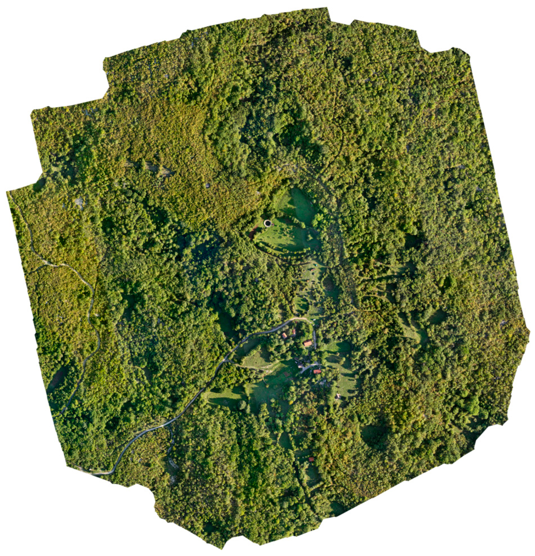
The study area is in Goranci, a small village northwest of Mostar, Bosnia and Herzegovina. Since the region is part of the Dinaric karst belt, it is characterized by a highly irregular topography, thin soils, and complex subsurface drainage systems. The hydrogeological and hydrological regimes of all water sources are reflected in the interaction between groundwater and surface water [15,16]. A narrower study area is connected to Lake Jezerac, built during the Roman Empire, which was, for some period of time, the only source of water for this area. The Goranci area serves as a representative case for applying such methods within Dinaric karst environments, in which the balance between growth and environmental protection is particularly delicate. In Figure 1, the study area is presented, and in Figure 2, the local-scale study area is presented.

2.1. Geological and Geomorphological Setting

Typically, the Dinaric karst morphology study area is dominated by Cretaceous and Jurassic limestones and dolomites, resulting in poor surface water retention and the frequent occurrence of closed depressions [15,16]. Figure 3 shows a geological map of Bosnia and Herzegovina. To model and evaluate land suitability, the use of LiDAR products such as DEM or DSM is recommended and has been used in different studies [3,17].

2.2. Pedological and Hydrological Characteristics and Climate Conditions

The soil cover is generally thin, discontinuous, and skeletal, composed primarily of terra rossa and rendzina-type soils developed on limestone. Due to the karst substrate, surface runoff is minimal, and infiltration dominates the hydrological regime [15,16]. The absence of permanent surface streams and the presence of underground conduits and ponors significantly influence water availability and constrain agricultural and construction activities.
Hydrologically, Goranci lies within the Neretva River Basin, but due to subsurface drainage patterns, delineating local catchment boundaries using traditional hydrological models is difficult. The integration of LiDAR-based DTM analysis with terrain indices such as the Topographic Wetness Index (TWI) and Convergence Index (CI) allows a more realistic identification of potential water accumulation zones [17,19].
The region experiences a transitional Mediterranean–continental climate, with warm, dry summers and moderately cold, wet winters. Average annual temperatures range from 12 to 14 °C, while yearly precipitation exceeds 1000 mm, mostly concentrated between October and April [20]. Analyses of solar radiation and sky-view factor (SVF) derived from DSM data can provide essential results for identifying well-insulated locations, as shaded or enclosed depressions may retain cold air masses and fog during winter months.

2.3. Spatial Development Constraints

Spatial development in the Goranci area faces several natural and infrastructural constraints. The most prominent are:
  • Steep slopes (locally exceeding 25°), increasing construction costs and limiting accessibility.
  • High variability in solar exposure due to complex relief.
  • Poor levels of water availability caused by rapid infiltration and lack of permanent watercourses.
  • Risk of soil erosion and terrain instability in areas with high slopes and shallow soil.
  • Limited transportation infrastructure, with most roads being narrow, unpaved, and seasonally affected by weather conditions.
These constraints highlight the need for data-driven spatial analyses that integrate LiDAR-based geomorphometry and MCDA to objectively determine optimal zones for residential development.

3. Materials and Methods

3.1. LiDAR Data Collection

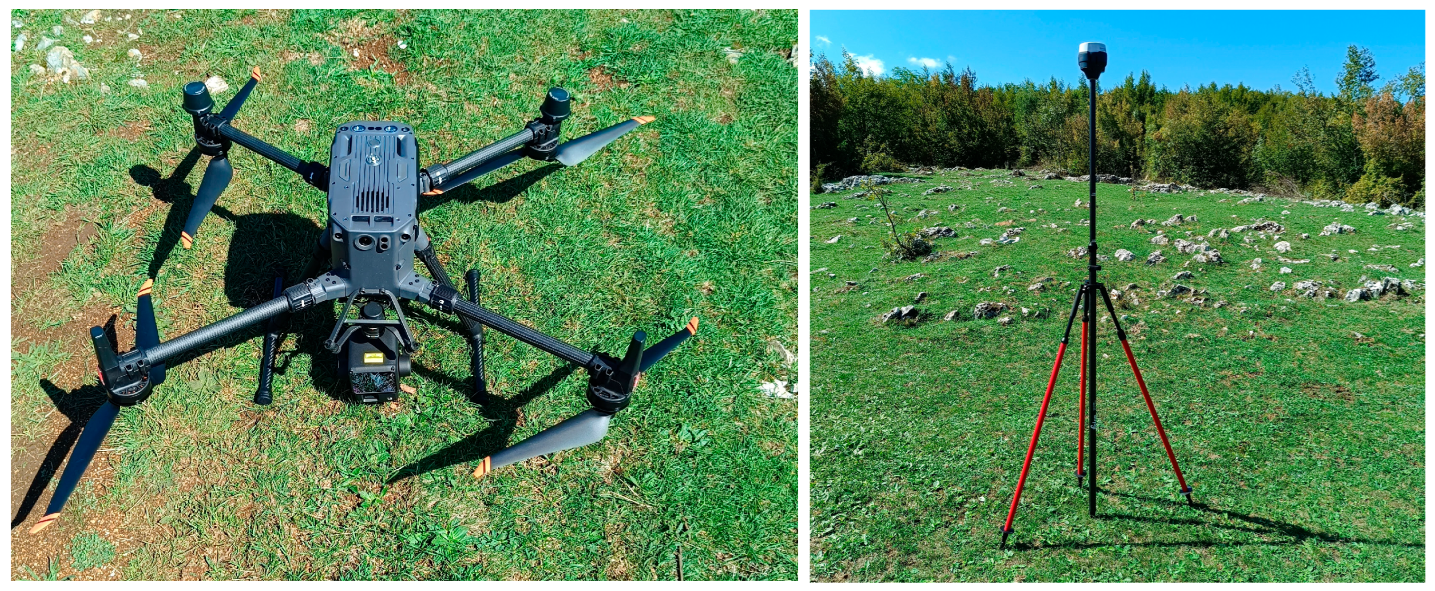
The core dataset used in this study comprises high-resolution LiDAR data collected using an unmanned aerial vehicle (UAV) equipped with a Zenmuse L2 LiDAR sensor, manufactured by DJI in Shenzhen, China, was sourced directly from DJI’s authorized distributor mounted on a DJI Matrice 350 RTK platform. The survey was conducted in 2025 and aimed at producing detailed topographic datasets for the Goranci area. The LiDAR system integrates a GNSS/IMU positioning unit and records up to 240,000 points per second, enabling the generation of dense, geometrically precise point clouds.
The point cloud was processed in DJI Terra software (version 5.0.0.) to produce two raster products:
  • Digital Surface Model (DSM)—representing the top surface, including vegetation and built features.
  • Digital Terrain Model (DTM)—representing the bare-earth surface derived through ground classification and interpolation using a TIN-based progressive densification algorithm.
Both DSM and DTM were exported as GeoTIFF rasters with a spatial resolution of 0.5 m, corresponding to an average point density of ≥200 points/m2. The coordinate reference system used was MGI 1901 Balkans zone 6 (EPSG: 8678), compatible with the official geodetic reference frame in Bosnia and Herzegovina (FBIHPOS network).
To ensure positional accuracy, the reference corrections were provided via the FBIHPOS (Federation of Bosnia and Herzegovina Positioning Service) network, achieving horizontal accuracy better than ±2 cm and vertical accuracy better than ±3 cm. Both the Matrice 350 and the Emlid Reach RS2 are shown in Figure 4.
The use of UAV LiDAR as a primary data source ensured sufficient vertical accuracy and surface detail to enable precise morphometric and hydrological modeling at the micro-topographic scale. This approach aligns with recent advances in LiDAR-supported land evaluation studies [3,4], where UAV-based data acquisition provides an efficient, cost-effective solution for high-resolution spatial planning in complex karst terrain.

3.2. Derivation of Morphometric and Environmental Parameters

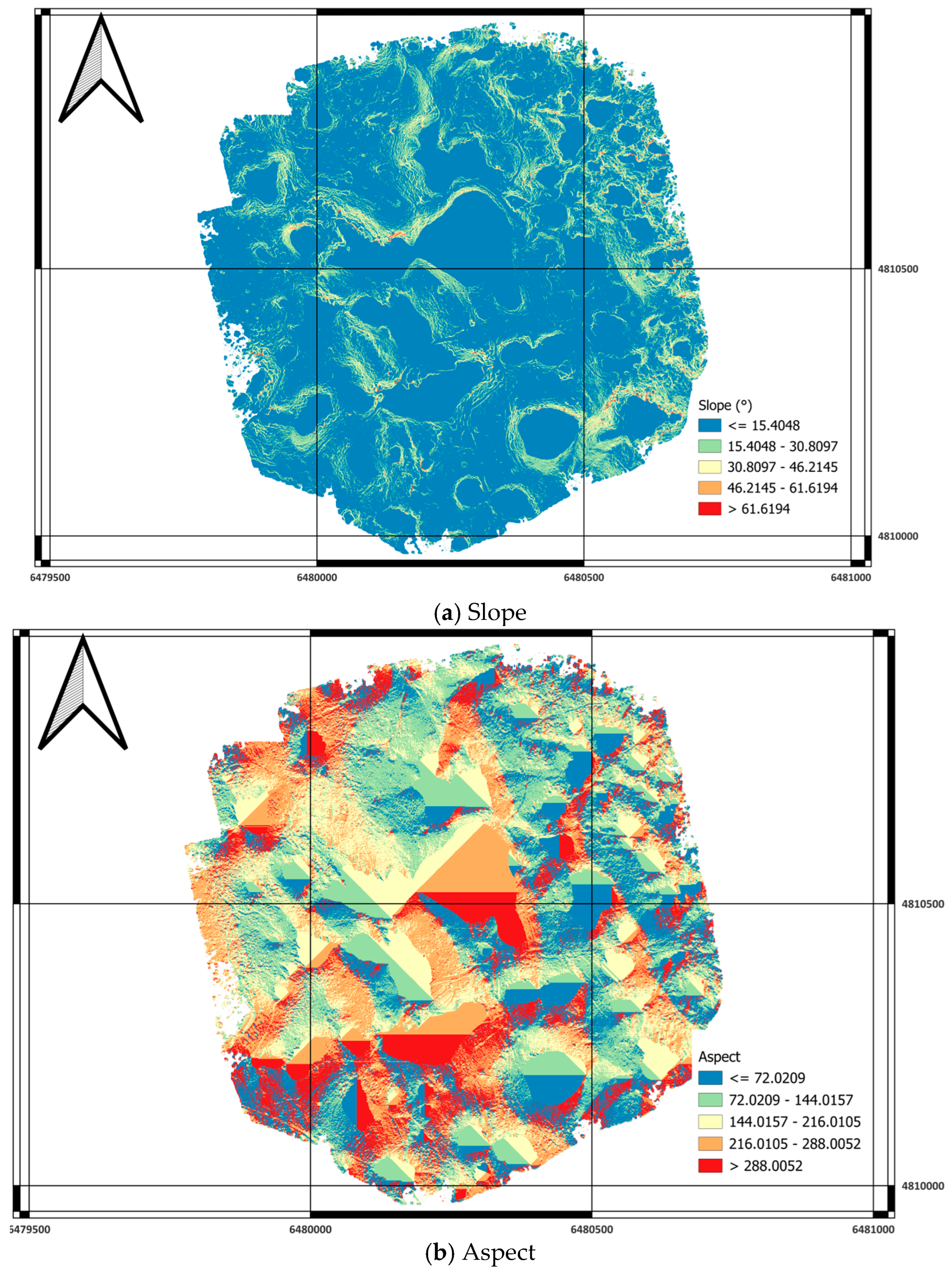
Terrain derivatives were computed in SAGA GIS (v 9.9.3) using modules from Terrain Analysis—Morphometry, Hydrology, and Lighting toolsets. Table 1 presents the parameters used, their descriptions, and their relevance for multicriteria analysis.
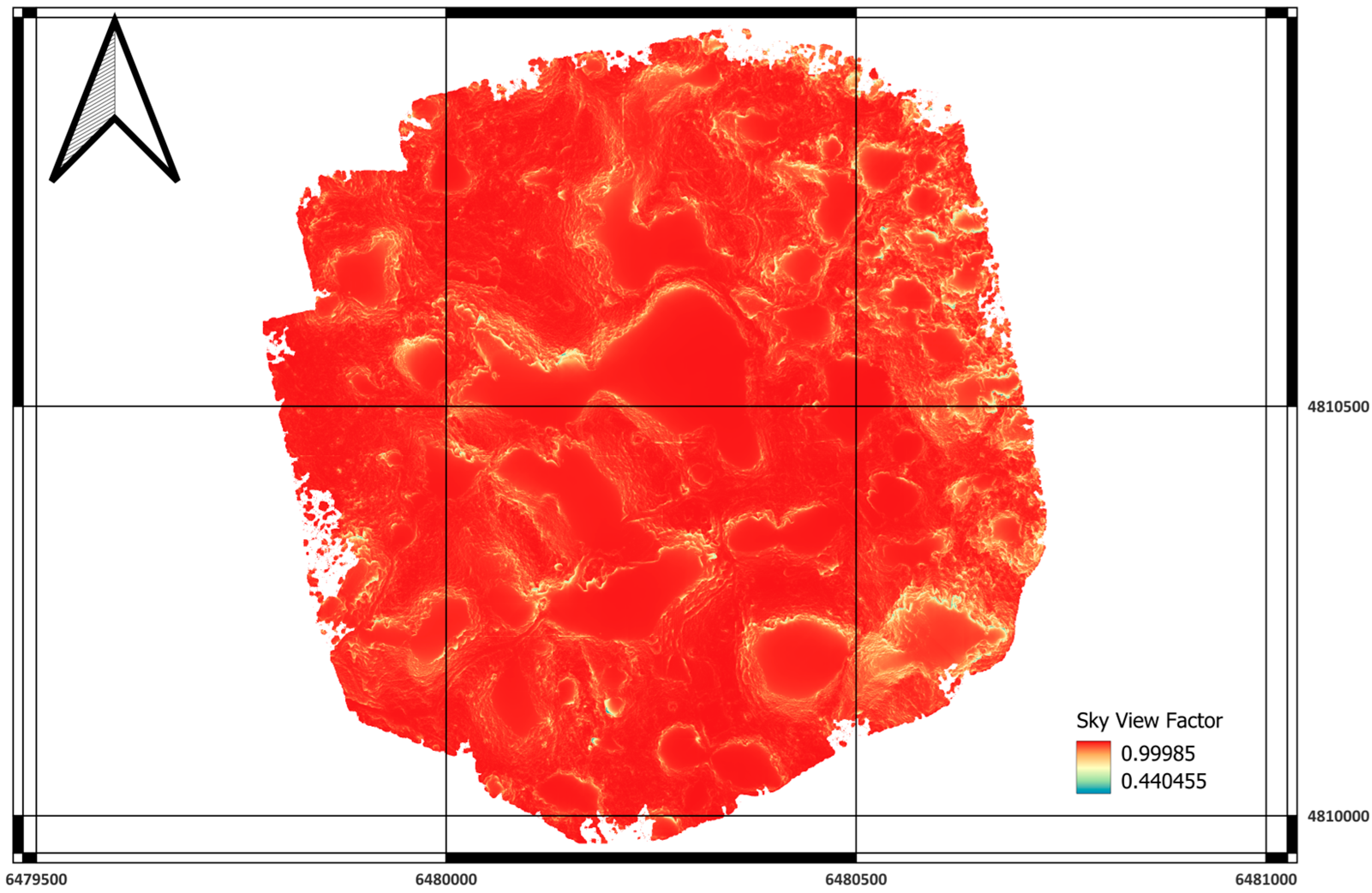
SVF results were calculated using SAGA GIS (module: Terrain Analysis-Lighting), at an azimuth step of 5°, a horizon step of 5°, and a maximum search radius of 100 m. The SVF threshold of ≥0.9 was chosen because of its relation to fully open sky conditions established in earlier studies of microclimate as well as in SVF studies using LiDAR data [21,22] and because this threshold differentiates open plateau surfaces from depressions characteristic of the Goranci karst area.
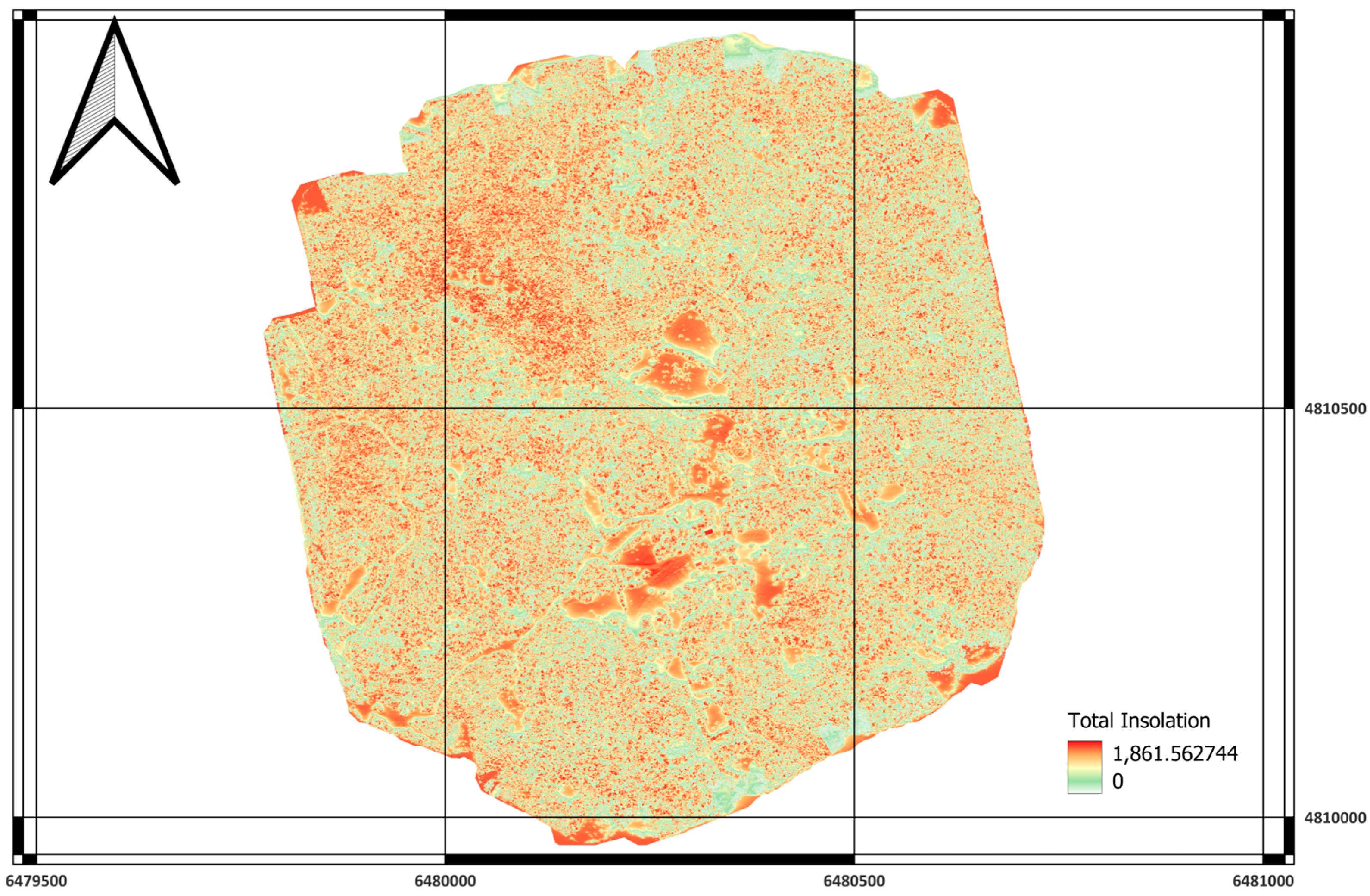
Since SAGA’s PISR model demands geographically expressed data, the LiDAR-based DTM data set needed to be reprojected from EPSG:8678 to EPSG:4326 prior to running the insolation analysis. Because of the small spatial extent of the study area as well as the high resolution of the DTM, reprojection caused only small distortions of geometry and radiometry (<0.5% distortion of cellular values).
SAGA GIS’s function “Rescale Grid Values” was used to bring all criteria into a range of values from 0 to 1, which is suitable for further analysis, without losing any information in the values of morphological and environmental criteria. The weighted linear combination analysis is only conducted upon values that range from 0 to 1.
Binary layers of 0 s and 1 s were created only for threshold-based classification of classes and summarization of area, but not for weightage assignment.
Threshold examples are shown in Table 2.
These thresholds originated from literature searches as well as local expertise. For instance, slopes less than 15° are generally suitable for traditional construction in mountainous as well as karst regions, whereas slopes steeper than 25–30° are either avoided altogether or significant engineering work is needed. The thresholds for TWI, for instance, TWI ≤ 4 for well-drained areas, originated from hydrological analyses associating low TWI values with low soil water accumulation [8], in addition to local expertise in Goranci, which indicated that depressions as well as dolines characterized by large values of TWI retain water. Likewise, an SVF of 0.9 originated from analyses suggesting that a SVF ≥ 0.9 is close to completely open sky [21,22].
To integrate the criteria into a single suitability index, a weighted linear combination method was used. Weights were determined based on expert judgement, the analytic hierarchy process (AHP), and a literature review [26,27,28,29,30,31,32,33], ensuring that the sum of all weights equaled 1.0 (Table 3). For the analysis of hierarchical relationships, the analytic hierarchy process (AHP) was employed as per Saaty (2008) [34]. A pairwise comparison matrix is developed using expert opinion, where each criterion is rated relative to another in terms of influence for settlement suitability (Slope, PSI/S, TWI, TRI, LS, SVF, TPI). The result of this is the normalizing principal eigenvector, producing final weights of Slope = (0.263); PISR = (0.211); TWI = (0.158); TRI = (0.105); LS = (0.105); SVF = (0.105); TPI = (0.053). A full judgment matrix is shown in Table A1, as is the weight matrix itself. The value of λmax, as well as the Consistency Index (CI), is calculated using Saaty’s formula, whereas Consistency Ratio (CR) is calculated by dividing CI by Random Index (RI) for n = 7, which is less than 0.10, implying a reasonable level of logical consistency for this set of comparisons, in terms of weight structure validity.
After that, the final suitability raster was evaluated to determine the pixel count and area per class. Areas with cell values < 0.5 were labeled as non-suitable, 0.5 < 0.6 as suitable, 0.6 < 0.7 as very appropriate, and >0.7 as highly suitable areas.

4. Results and Discussions

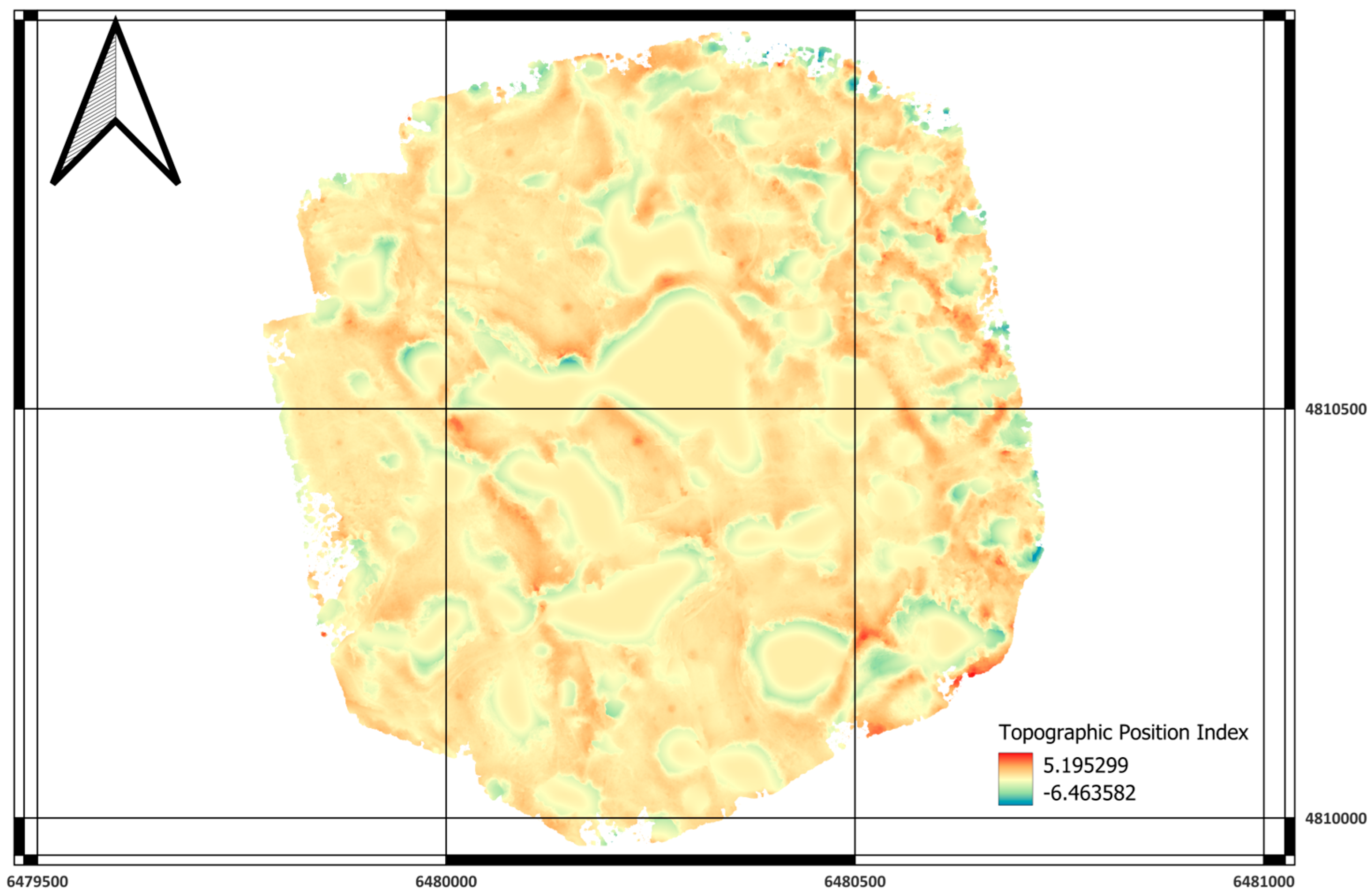
Following the derivation of morphometric and environmental indicators from the LiDAR-based Digital Terrain Model, seven standardized grids were produced: Slope, Terrain Ruggedness Index (TRI), Topographic Wetness Index (TWI), LS-Factor, Potential Incoming Solar Radiation (PISR), Sky-View Factor (SVF), and Topographic Position Index (TPI). Each was reclassified into a binary raster (0 = unsuitable; 1 = suitable) according to the criteria defined in Section 3.2. The results demonstrated strong internal consistency between slope, TRI, and LS-factor, indicating that erosion potential and terrain roughness are primarily controlled by slope inclination, a finding consistent with [23,24]. High-resolution visualization confirmed that the UAV LiDAR dataset captured microtopographic features, such as dolines, escarpments, and small plateaus, which are crucial for fine-scale spatial decision support but are typically unresolved in coarser DEMs.
Based on results derived from Table 2 and Table 3, statistical analysis (Table 4) revealed that approximately 30% of the study area (classes 3 and 4) is classified as highly to very highly suitable for potential settlement, 14% as low to moderately suitable (classes 1 and 2). In comparison, 53% of the area is masked or unsuitable (class 0) due to terrain limitations or the absence of LiDAR coverage.
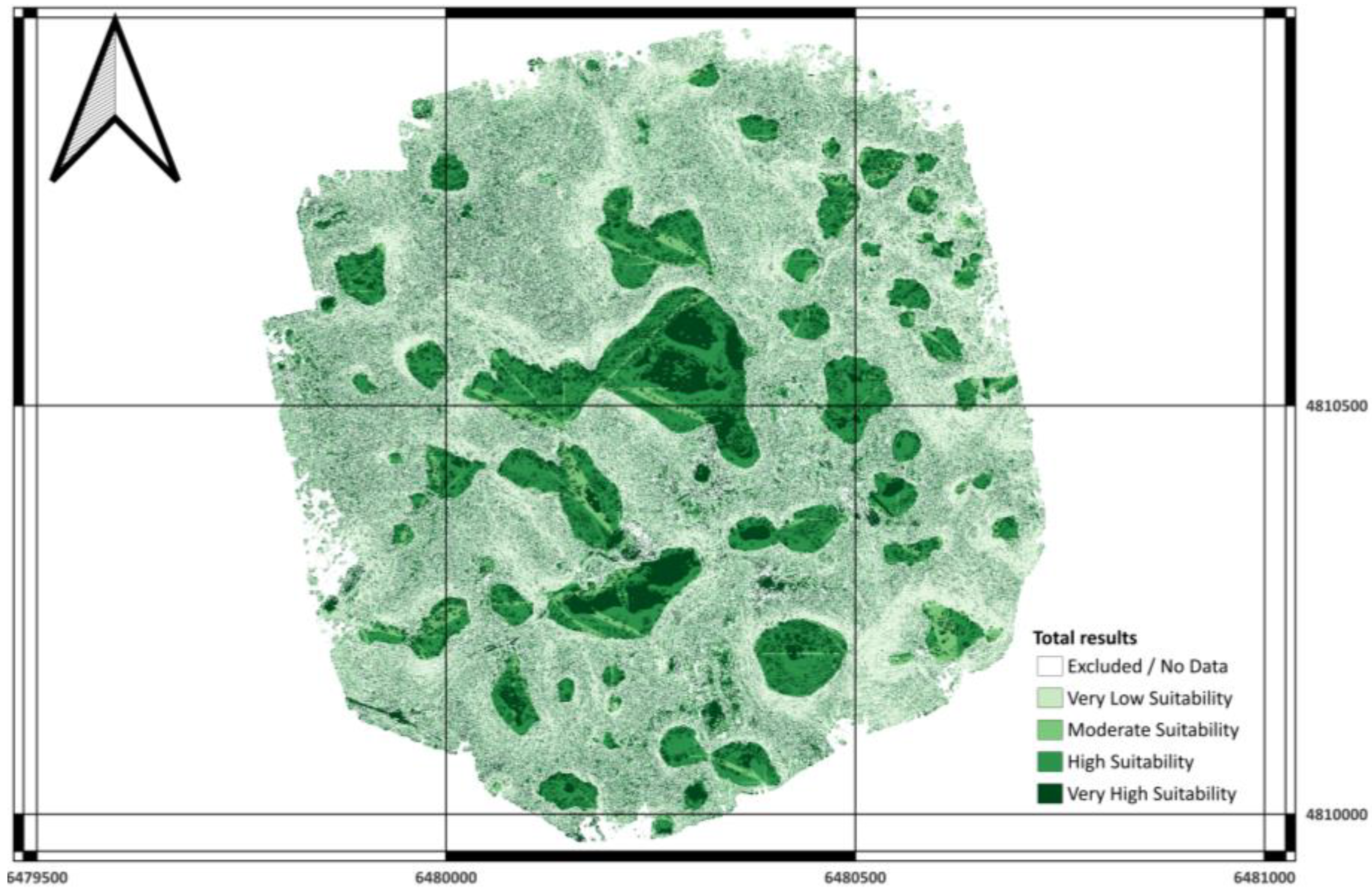
Spatial inspection of the final suitability raster revealed a coherent and geomorphologically plausible pattern (Figure 5).
  • Class 4 (very high suitability) zones are predominantly located on gently inclined karst plateaus and slightly elevated terraces characterized by slopes ≤ 15°, high solar insolation (PISR ≥ 1200 Wh/m2), and high sky openness (SVF ≥ 0.9). These conditions provide optimal microclimatic comfort and minimal earthwork for potential low-density residential development.
  • Class 3 (high suitability) areas extend along transitional slopes and gently rolling terrain; although slightly more inclined, they remain structurally stable and well-drained.
  • Classes 1–2 (low–moderate suitability) are associated with shaded northern slopes, localized depressions, and concave landforms with higher TWI values, reflecting temporary moisture retention and reduced solar exposure.
  • Class 0 (excluded) coincides with deep dolines, steep escarpments, and hydrologically active channels identified through the LiDAR DTM.
This map illustrates the ability of LiDAR-derived morphometric factors to capture nuanced micro- relief patterns of drainage, radiation patterns, and construction feasibility. The produced map illustrates the objectivity of the space-imaged terrain. The suitability factor verification revealed the dominance of slope and solar radiation factors, PISR among the output factors of final suitability map generation, contributing nearly 47% to the total weight. This represents conformity among the majority of the previous studies emphasizing the dominance of slope factors, as described earlier in the context of ARS studies [32], among other studies. The remaining lower-weighted factors, TRI, LS, SVF, and TPI, complemented each other. Examples include the ability to represent the convex ridges and the concave valleys from the planar ground, as described in the previous section, through the map layer TPI. SVF complemented the distinction among the remaining factors related to the microwave cold (versus warm) locations. Including the factor TWI (its weighing factor of 0.1579) allowed the penalized factor to realistically render the unfavorably humidified water-locus found in the realistic indices illustrated in Everest et al. [25] studies. Arraying weights following the principles described in general ARS principles in this context is illustrated in the studies from the other authors, and reinforced by the authors of reference [29] studies.
The achieved pattern of suitability determinations matches the results obtained in similar studies involving LiDAR-based MCDA systems [23,35]. In both studies, slope and roughness were identified as the most important factors influencing the results of suitability, while solar radiation and wetness factors were recognized as the sources of secondary detail. Nonetheless, the above-mentioned studies differ from the present work in the fact that the former used a binary reclassification method before the weighing procedure. Moreover, the 0.5 m resolution LiDAR DTM utilized has a greater precision than the publicly available DEMs at 1–5 m resolution. This proves the value of the integration of the UAV-LiDAR system in the planning of regional spatial development in the form of digital twin systems that necessitate continuous updating of the processed information. The results demonstrate that high-resolution morphometric analysis can significantly improve decision-making in spatial planning. In Goranci, approximately one-third of the landscape exhibits terrain conditions favorable for development, while over half remains unsuitable due to geological and hydrological constraints. Such quantification directly supports evidence-based spatial planning, allowing planners to delineate development zones that minimize environmental degradation and infrastructure costs. The approach also provides a methodological foundation for regional digital twin models, where the LiDAR-derived surface, combined with real-time ecological and socioeconomic data, can simulate land-use scenarios and inform resilience-oriented planning strategies.
Although the above-presented methodology has shown the potential of the fusion of UAV LiDAR data and the GIS-based multi-criteria decision analysis for the terrain suitability analysis, several limitations should be considered:
  • Data coverage and computational constraints
The spatial resolution achieved in the UAV LiDAR scan was very high (<0.1 m). However, the area covered remained confined to the Goranci pilot region. This was attributed to the UAV’s functioning limitations: battery life capacity, flight height above the terrain, visibility requirements, and airspace regulations. Based on the currently limited computational capacity, the spatial resolution of 0.1 m had to be resampled at 0.5 m resolution. Thus, the applicability of the model to other regional locations could remain limited until the availability of more extensive coverage of the LiDAR dataset. Moreover, the differences in the point density of the strip patterns can sometimes create discrepancies between the interpolations of the DTM. In future studies, for example, by combining results from UAV-based LiDAR analysis in small regions (close to Goranci, for instance) with those from airborne or even national LiDAR mapping, more efficient methods of data analysis (tiling, for instance, using cloud computing) can be employed to carry out multi-scaling analysis of suitabilities.
  • Subjectivity in weight assessment
The weighting structure chosen based on the AHP reasoning pattern uses more empirical and subjective reasoning than calibration. Even when the results were found to remain stable through the tests of the sensitivity analysis, the objective nature of the weights chosen still represents a risk of bias. Future studies should develop ways to test more objective weights based on the data or random forest feature importance. While the value for the consistency ratio is acceptable, as well as the sensitivity tests, in further research, regression analysis, such as Random Forest Feature Importance, entropy-weight methods, for example, may also be explored to eliminate subjectivity to a large extent in determining weights.
  • Static representation of dynamic environments
The LiDAR data are a snapshot of the landscape at a given stage of seasonality and atmosphere. The reflectivity of the landscape and the status of the vegetation can affect the definition of the points as well as the creation of the derived rasters (TWI, SVF, PISR). The current model is based upon static LiDAR data and terrain indices, and does not account for time-related variations including vegetation, soil moisture, and climate conditions as a function of seasonality. Closing this gap, future studies should incorporate time-series data (e.g., satellite soil moisture, climate data) to create updateable suitability classes, which in turn would be an input into dynamic digital twin systems for scenario analysis.
  • Absence of Socio-Economic and Infrastructure factors
The current analysis focuses exclusively on morphometric and environmental parameters, omitting socio-economic, infrastructural, and legal constraints (e.g., land ownership, zoning, accessibility, proximity to services). While this topography-centric approach is appropriate for early-stage planning, it does not encompass the full spectrum of multi-dimensional sustainability criteria required in final spatial planning decisions.
Thresholds used for binary reclassification (e.g., slope ≤ 15°, TWI ≤ 4) were determined empirically based on the literature and terrain inspections. However, these values may not universally represent suitability boundaries in other geomorphological or climatic contexts. A fuzzy-logic or continuous-suitability approach could better capture uncertainty near classification thresholds and reduce abrupt transitions between classes. Although LiDAR and GNSS provided high geometric accuracy, the suitability outputs were not directly validated against actual land use, soil stability, or hydrological observations. While this analysis is focused on biophysical suitability, in future work, it is recommended to extend the MCDA framework to incorporate influences from the socio-economic, infrastructural, legal, and cultural domains, such as ownership, zoning regulations, accessibility by roads, and proximity to facilities, in an effort to transition from biophysical to comprehensive suitability analyses. Despite these limitations, the proposed LiDAR–GIS–MCDA framework demonstrates high reproducibility, flexibility, and scalability for terrain-based planning. Addressing the noted constraints—through expanded LiDAR coverage, data-driven weighting, and integration of socio-economic and environmental layers—will further enhance the robustness and transferability of this methodology across other karst and mountainous regions.

5. Conclusions

This paper shows that UAV-delivered LiDAR data fused into GIS-based multi-criteria decision analysis can be successfully applied for high-resolution suitability mapping of terrain for sustainable settlement zones development in karst areas. Based on a test area in Goranci, a set of seven morphometric properties, including slope, terrain ruggedness index (TRI), topographic wetness index (TWI), LS-factor, potential incoming solar radiation (PISR), sky view factor (SVF), and topographic position index (TPI) was extracted from a 0.1 m resolution LiDAR DTM resampled to 0.5 m. All of them have been normalized, reclassified, and aggregated by weighted linear combination (WLC) to obtain a composite suitability indicator for housing development. Analysis of resulting suitability mapping showed that some 30% of the area (classes 3–4) was highly or very highly suited for housing development due to gentle slopes, high solar insolation, low roughness of the terrain’s landward face, and good drainage conditions and that some 14% was rated as of lower suitability while more than half of the entire area was environmentally restricted or excluded (sinkholes, escarpments, or lands outside of UAV coverage). This can be taken to indicate that morphometric properties and solar radiation have the most significant influence on the settlement suitability of complex karst terrain. The application of SAGA GIS and QGIS enables transparent, reproducible parameterization and weighting using user-defined suitability criteria that can be adjusted at every decision-making step. Also, the integration of LiDAR/GNSS/GIS technology on a joint MCDA platform can serve as a good foundation for future applications of digital twins for spatial planning, where one can update the actual terrain to make necessary decisions with no restrictions on space–time dependence. Further improvements can be achieved by increasing LiDAR mapping of terrain, adding socio-economic and infrastructural indicators to suitability mapping with machine learning weighting of criteria to get rid of subjective assessments that can increase the strength of the procedure’s independence.
A visual analysis of the suitability map of Goranci versus the location of current residential buildings reveals that only a few of them are in highly suitable regions. This is to be expected, as Goranci is known to be sparsely populated, featuring isolated dwellings as distinct from compact residential zones. Moreover, although only few of the current residential buildings in Goranci align themselves in regions characterized by suitable morphometry, like flat regions, gentle slopes, and an easily accessible plateau topography, this does also suggest that even in Goranci, residents, perhaps unconsciously, opted for regions of more stable and accessible topography, but by no means was this the case in every instance, as other areas, for example, regions characterized by terrain depressions, steeper slopes, but also perhaps by other criteria like heritage plots, availability, as well as perhaps family property, also played a contributing role. From an applied perspective, suitability layers designed in this work could benefit local and regional planners in assessing regions offering more favorable conditions for low-density development by providing relatively safe and sustainable zones for this purpose. These suitability layers could also be used as a tool for making informed decisions regarding potential locations for buildings, infrastructure development, as well as areas to be explored in the field for further data acquisition, by examining potential locations using a set of criteria established in this work, which could then be amended to accommodate different karst conditions in other regions, taking into account differences in threshold values for variables such as gradient and wetness index.
This study clearly shows that precision-level spatial intelligence can be obtained using UAV LiDAR sensors in combination with open-source geospatial analysis applications at a fraction of the cost of current commercial solutions.
In a general sense, this study can be viewed as contributing to evidence-based spatial planning and sustainable rural development through a quantitative method for identifying micro-location points for housing development, infrastructure projects, and renewable energy installations. This study not only increases the understanding of geomorphometric factors of human settlement patterns for karst topography but also sets the basis for future digital twin applications.

Author Contributions

Conceptualization, N.K. and D.Š.; methodology, N.K.; software, N.K.; validation, B.Đ., D.Š., and V.C.; formal analysis, D.Š.; investigation, N.K.; resources, N.K.; data curation, N.K. and D.Š.; writing—original draft preparation, N.K. and D.Š.; writing—review and editing, B.Đ. and V.C.; visualization, N.K.; supervision, V.C.; project administration, N.K.; funding acquisition, N.K. All authors have read and agreed to the published version of the manuscript.

Funding

This research was funded by University North, under project Comparing LiDAR data with publicly available datasets, UNIN-TEH-25-1-13.

Institutional Review Board Statement

Not applicable.

Informed Consent Statement

Not applicable.

Data Availability Statement

Data will be made available upon a reasonable request to authors.

Acknowledgments

The authors would like to express their sincere gratitude to the University North, Department of Geodesy and Geomatics (Croatia), for providing institutional and technical support during UAV data collection and LiDAR processing.

Conflicts of Interest

The authors declare no conflicts of interest.

Appendix A

Table A1. Pairwise comparison matrix and derived weights of criteria used in the AHP.
CriteriaSlopePISRTWITRILSSVFTPIWeight
Slope1.001.251.672.502.502.505.000.263
PISR0.801.001.332.002.002.004.000.211
TWI0.600.751.001.501.501.503.000.158
TRI0.400.500.671.001.001.002.000.105
LS0.400.500.671.001.001.002.000.105
SVF0.400.500.671.001.001.002.000.105
TPI0.200.250.330.500.500.501.000.053
Figure A1. (a) Slope. (b) Aspect.
Sustainability 17 10508 g0a1
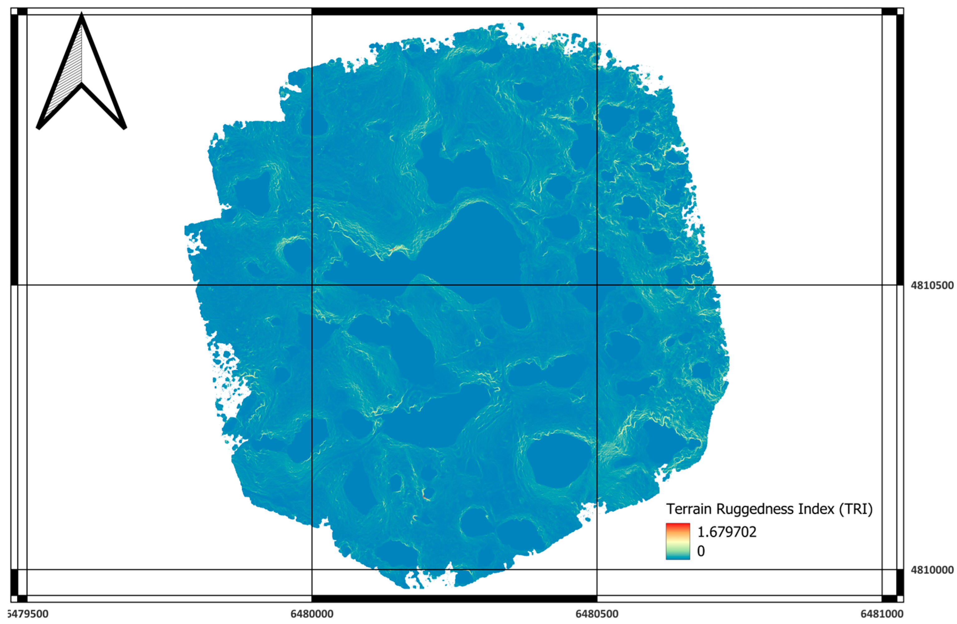
Figure A2. Terrain ruggedness index.
Sustainability 17 10508 g0a2
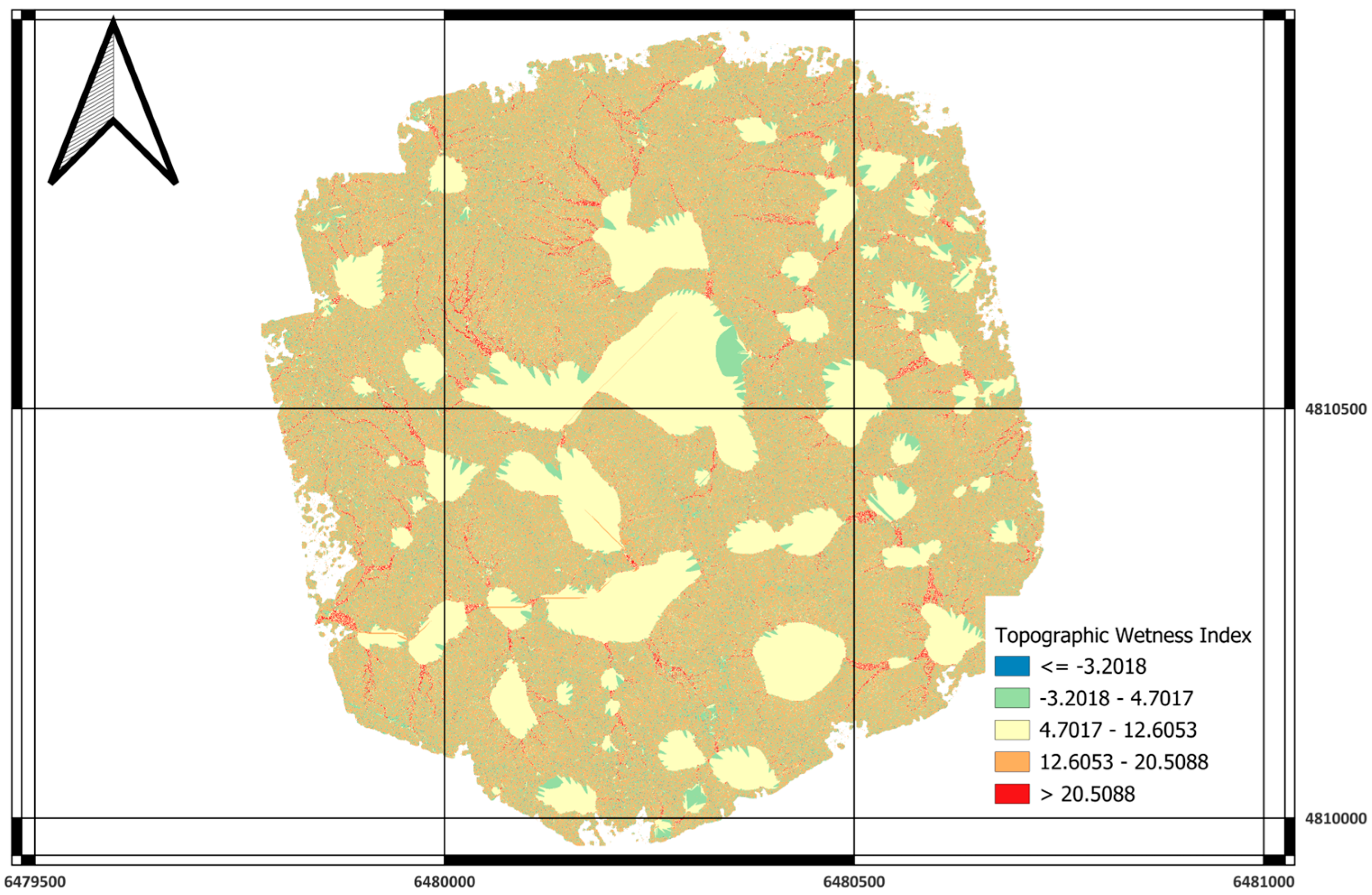
Figure A3. Topographic wetness index.
Sustainability 17 10508 g0a3
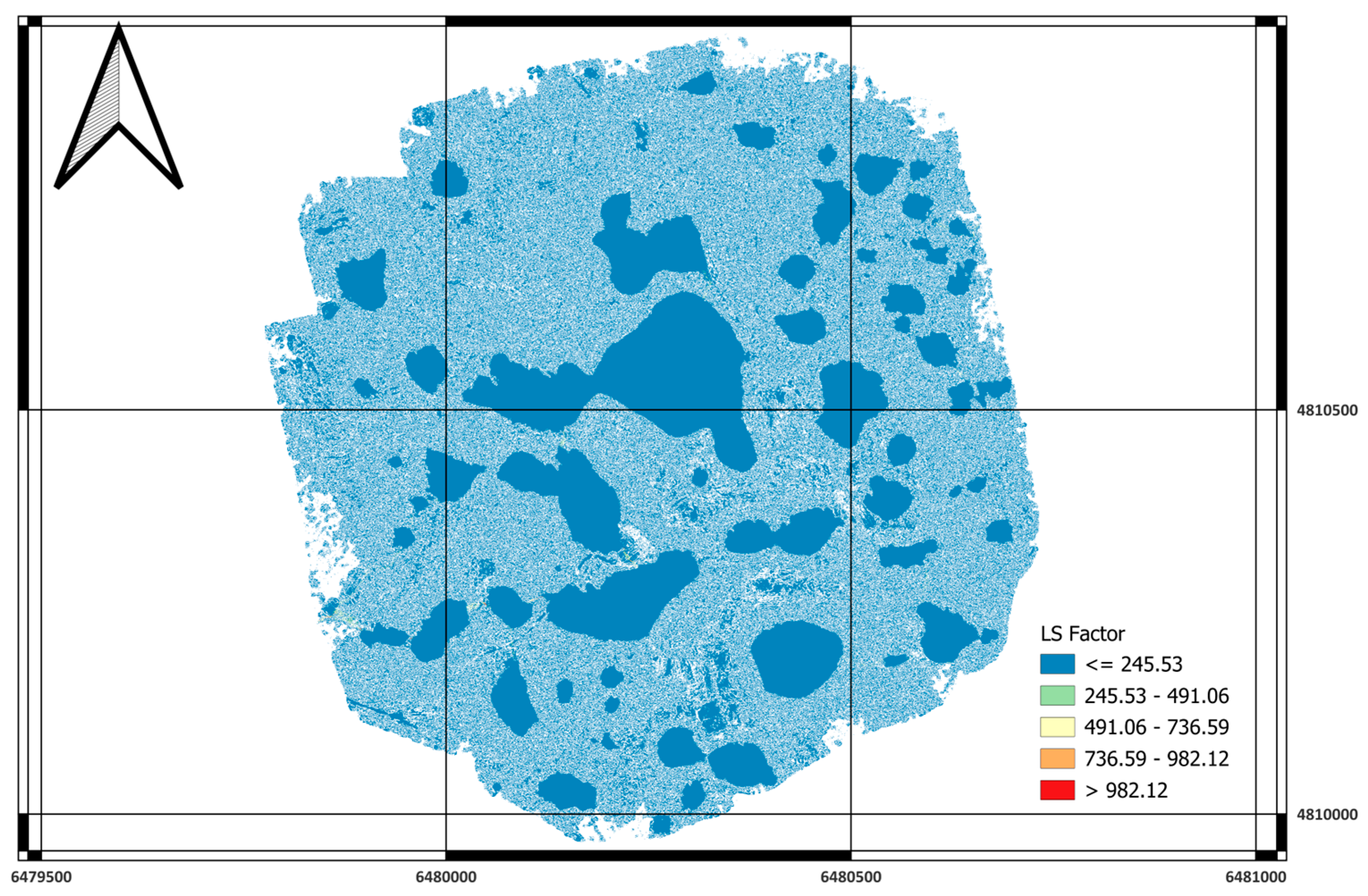
Figure A4. LS factor.
Sustainability 17 10508 g0a4
Figure A5. Topographic Position index.
Sustainability 17 10508 g0a5
Figure A6. Sky View factor.
Sustainability 17 10508 g0a6
Figure A7. Potential for incoming solar radiation.
Sustainability 17 10508 g0a7

References

  1. Telbisz, T. Lidar-Based Morphometry of Conical Hills in Temperate Karst Areas in Slovenia. Remote Sens. 2021, 13, 2668. [Google Scholar] [CrossRef]
  2. Kim, J.; Hong, I. Evaluation of the Usability of UAV LiDAR for Analysis of Karst (Doline) Terrain Morphology. Sensors 2024, 24, 7062. [Google Scholar] [CrossRef]
  3. Telbisz, T.; Mari, L.; Székely, B. LiDAR-Based Morphometry of Dolines in Aggtelek Karst (Hungary) and Slovak Karst (Slovakia). Remote Sens. 2024, 16, 737. [Google Scholar] [CrossRef]
  4. Ko, S.-J.; Hong, S.; Kwak, T.-Y. Development of a UAV LiDAR-Based Framework for Consolidation Settlement Monitoring Through Spatial Analysis. J. Mar. Sci. Eng. 2025, 13, 1106. [Google Scholar] [CrossRef]
  5. Wei, G.; He, B.J.; Sun, P.; Liu, Y.; Li, R.; Ouyang, X.; Luo, K.; Li, S. Evolutionary Trends of Urban Expansion and Its Sustainable Development: Evidence from 80 Representative Cities in the Belt and Road Initiative Region. Cities 2023, 138, 104353. [Google Scholar] [CrossRef]
  6. Arabameri, A.; Rezaie, F.; Pal, S.C.; Cerda, A.; Saha, A.; Chakrabortty, R.; Lee, S. Modelling of Piping Collapses and Gully Headcut Landforms: Evaluating Topographic Variables from Different Types of DEM. Geosci. Front. 2021, 12, 101230. [Google Scholar] [CrossRef]
  7. Arabameri, A.; Pradhan, B.; Rezaei, K.; Yamani, M.; Pourghasemi, H.R.; Lombardo, L. Spatial Modelling of Gully Erosion Using Evidential Belief Function, Logistic Regression, and a New Ensemble of Evidential Belief Function–Logistic Regression Algorithm. Land. Degrad. Dev. 2018, 29, 4035–4049. [Google Scholar] [CrossRef]
  8. Chang, K.T.; Merghadi, A.; Yunus, A.P.; Pham, B.T.; Dou, J. Evaluating Scale Effects of Topographic Variables in Landslide Susceptibility Models Using GIS-Based Machine Learning Techniques. Sci. Rep. 2019, 9, 12296. [Google Scholar] [CrossRef]
  9. Chakrabortty, R.; Pal, S.C.; Chowdhuri, I.; Malik, S.; Das, B. Assessing the Importance of Static and Dynamic Causative Factors on Erosion Potentiality Using SWAT, EBF with Uncertainty and Plausibility, Logistic Regression and Novel Ensemble Model in a Sub-Tropical Environment. J. Indian Soc. Remote Sens. 2020, 48, 765–789. [Google Scholar] [CrossRef]
  10. Abdelkarim, A.; Al-Alola, S.S.; Alogayell, H.M.; Mohamed, S.A.; Alkadi, I.I.; Ismail, I.Y. Integration of GIS-Based Multicriteria Decision Analysis and Analytic Hierarchy Process to Assess Flood Hazard on the Al-Shamal Train Pathway in Al-Qurayyat Region, Kingdom of Saudi Arabia. Water 2020, 12, 1702. [Google Scholar] [CrossRef]
  11. Maxwell, A.E.; Shobe, C.M. Land-Surface Parameters for Spatial Predictive Mapping and Modeling. Earth Sci. Rev. 2022, 226, 103944. [Google Scholar] [CrossRef]
  12. Malczewski, J. GIS-based Multicriteria Decision Analysis: A Survey of the Literature. Int. J. Geogr. Inf. Sci. 2006, 20, 703–726. [Google Scholar] [CrossRef]
  13. Romano, G.; Dal Sasso, P.; Trisorio Liuzzi, G.; Gentile, F. Multi-Criteria Decision Analysis for Land Suitability Mapping in a Rural Area of Southern Italy. Land. Use Policy 2015, 48, 131–143. [Google Scholar] [CrossRef]
  14. Yalew, S.G.; van Griensven, A.; van der Zaag, P. AgriSuit: A Web-Based GIS-MCDA Framework for Agricultural Land Suitability Assessment. Comput. Electron. Agric. 2016, 128, 1–8. [Google Scholar] [CrossRef]
  15. Bonacci, O.; Željković, I.; Galić, A. Karst Rivers’ Particularity: An Example from Dinaric Karst (Croatia/Bosnia and Herzegovina). Environ. Earth Sci. 2013, 70, 963–974. [Google Scholar] [CrossRef]
  16. Bonacci, O. Karst Hydrogeology/Hydrology of Dinaric Chain and Isles. Environ. Earth Sci. 2015, 74, 37–55. [Google Scholar] [CrossRef]
  17. Kim, J.; Hong, I. Analysis of Doline Microtopography in Karst Mountainous Terrain Using UAV LiDAR: A Case Study of ‘Gulneomjae’ in Mungyeong City, South Korea. Sensors 2025, 25, 4350. [Google Scholar] [CrossRef]
  18. Čikić, S.; Čičić, S.; Avdagić, I.; Čičić, E. Geological Map of Bosnia and Herzegovina 1:300000. Available online: https://fzzg.gov.ba/file/gk300000-opt21/256 (accessed on 22 November 2024).
  19. Kobal, M.; Bertoncelj, I.; Pirotti, F.; Dakskobler, I.; Kutnar, L. Using Lidar Data to Analyse Sinkhole Characteristics Relevant for Understory Vegetation under Forest Cover—Case Study of a High Karst Area in the Dinaric Mountains. PLoS ONE 2015, 10, e0122070. [Google Scholar] [CrossRef]
  20. Federal Hydrometeorological Institute of Bosnia and Herzegovina. Climatological Analysis for the Year 2023; Federal Hydrometeorological Institute of Bosnia and Herzegovina: Sarajevo, Bosnia and Herzegovina, 2024. [Google Scholar]
  21. Dirksen, M.; Ronda, R.J.; Theeuwes, N.E.; Pagani, G.A. Sky View Factor Calculations and Its Application in Urban Heat Island Studies. Urban. Clim. 2019, 30, 100498. [Google Scholar] [CrossRef]
  22. Hodul, M.; Knudby, A.; Ho, H.C. Estimation of Continuous Urban Sky View Factor from Landsat Data Using Shadow Detection. Remote Sens. 2016, 8, 568. [Google Scholar] [CrossRef]
  23. Okoli, J.; Nahazanan, H.; Nahas, F.; Kalantar, B.; Shafri, H.Z.M.; Khuzaimah, Z. High-Resolution Lidar-Derived DEM for Landslide Susceptibility Assessment Using AHP and Fuzzy Logic in Serdang, Malaysia. Geosciences 2023, 13, 34. [Google Scholar] [CrossRef]
  24. Mahalingam, R.; Olsen, M.J.; O’Banion, M.S. Evaluation of Landslide Susceptibility Mapping Techniques Using Lidar-Derived Conditioning Factors (Oregon Case Study). Geomat. Nat. Hazards Risk 2016, 7, 1884–1907. [Google Scholar] [CrossRef]
  25. Everest, T.; Sungur, A.; Özcan, H. Determination of Agricultural Land Suitability with a Multiple-Criteria Decision-Making Method in Northwestern Turkey. Int. J. Environ. Sci. Technol. 2021, 18, 1073–1088. [Google Scholar] [CrossRef]
  26. Rahmati, O.; Pourghasemi, H.R.; Melesse, A.M. Application of GIS-Based Data Driven Random Forest and Maximum Entropy Models for Groundwater Potential Mapping: A Case Study at Mehran Region, Iran. Catena 2016, 137, 360–372. [Google Scholar] [CrossRef]
  27. Bathrellos, G.D.; Skilodimou, H.D.; Chousianitis, K.; Youssef, A.M.; Pradhan, B. Suitability Estimation for Urban Development Using Multi-Hazard Assessment Map. Sci. Total Environ. 2017, 575, 119–134. [Google Scholar] [CrossRef] [PubMed]
  28. Mosadeghi, R.; Warnken, J.; Tomlinson, R.; Mirfenderesk, H. Comparison of Fuzzy-AHP and AHP in a Spatial Multi-Criteria Decision Making Model for Urban Land-Use Planning. Comput. Environ. Urban. Syst. 2015, 49, 54–65. [Google Scholar] [CrossRef]
  29. Chen, Y.; Yu, J.; Khan, S. Spatial Sensitivity Analysis of Multi-Criteria Weights in GIS-Based Land Suitability Evaluation. Environ. Model. Softw. 2010, 25, 1582–1591. [Google Scholar] [CrossRef]
  30. Meng, F.; Liang, X.; Xiao, C.; Wang, G. Geothermal Resource Potential Assessment Utilizing GIS—Based Multi Criteria Decision Analysis Method. Geothermics 2021, 89, 101969. [Google Scholar] [CrossRef]
  31. Veronesi, F.; Schito, J.; Grassi, S.; Raubal, M. Automatic Selection of Weights for GIS-Based Multicriteria Decision Analysis: Site Selection of Transmission Towers as a Case Study. Appl. Geogr. 2017, 83, 78–85. [Google Scholar] [CrossRef]
  32. Morales, F.; de Vries, W.T. Establishment of Land Use Suitability Mapping Criteria Using Analytic Hierarchy Process (AHP) with Practitioners and Beneficiaries. Land 2021, 10, 235. [Google Scholar] [CrossRef]
  33. AbdelRahman, M.A.E.; Yossif, T.M.H.; Metwaly, M.M. Enhancing Land Suitability Assessment through Integration of AHP and GIS-Based for Efficient Agricultural Planning in Arid Regions. Sci. Rep. 2025, 15, 31370. [Google Scholar] [CrossRef] [PubMed]
  34. Saaty, T.L. Decision Making with the Analytic Hierarchy Process. Int. J. Serv. Sci. 2008, 1, 83. [Google Scholar] [CrossRef]
  35. Mugiyo, H.; Chimonyo, V.G.P.; Sibanda, M.; Kunz, R.; Masemola, C.R.; Modi, A.T.; Mabhaudhi, T. Evaluation of Land Suitability Methods with Reference to Neglected and Underutilised Crop Species: A Scoping Review. Land 2021, 10, 125. [Google Scholar] [CrossRef] [PubMed]
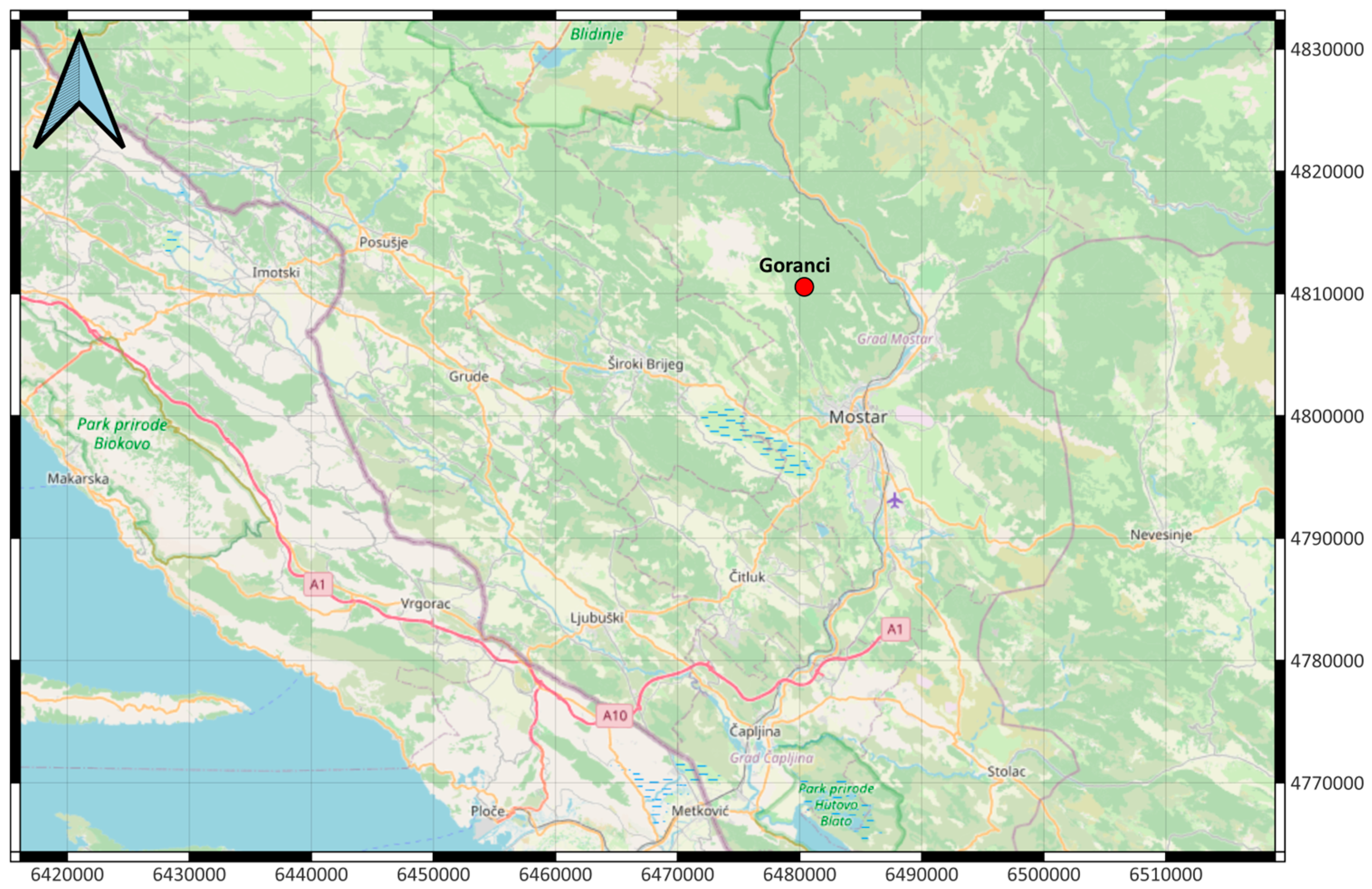
Figure 1. Study area location.
Sustainability 17 10508 g001
Figure 2. Local scale study area location.
Sustainability 17 10508 g002
Figure 3. Geological map of Bosnia and Herzegovina [18].
Sustainability 17 10508 g003
Figure 4. DJI Matrice 350 RTK (left) and Emlid Reach RS2 (right).
Sustainability 17 10508 g004
Figure 5. Total results.
Sustainability 17 10508 g005
Table 1. Parameters and descriptions.
ParameterDescriptionSAGA ModuleRelevanceCross Reference
Slope (°)Angle of inclination derived from DTMSlope, Aspect CurvatureIndicates construction feasibility and stabilityFigure A1a,b
TRI (Terrain Ruggedness Index)Mean elevation difference between a cell and its neighborsTerrain Ruggedness IndexMeasures surface roughness; smoother terrain = higher suitabilityFigure A2
TWI (Topographic Wetness Index)ln (Ac/tan β), where Ac is the upslope contributing areaTopographic Wetness IndexIdentifies potential moisture accumulation; drier = betterFigure A3
LS FactorSlope length–steepness factor from RUSLELS-FactorIndicates erosion susceptibility; lower = betterFigure A4
TPI (Topographic Position Index)Relative elevation compared to the surrounding terrainTopographic Position IndexDistinguishes ridges, valleys, and mid-slopesFigure A5
SVF (Sky View Factor)Portion of the visible sky hemisphereSky View FactorRelates to openness, cold-air drainage, and microclimateFigure A6
PISR (Potential Incoming Solar Radiation)Annual insolation energy (Wh/m2)Potential Incoming Solar RadiationRepresents solar exposure; higher = better for living conditionsFigure A7
Table 2. Thresholds examples.
ParameterOptimal ConditionNon-OptimalSuitability Logic
Slope (°)≤15°>15°More suitable is flatter terrain [23]
TRI≤0.30>0.30Low surface roughness favored [24]
TWI≤4.0>4.0Well-drained areas preferred [24]
LS Factor≤5>5Low erosion risk suitable [24,25]
TPI −2 ≤ TPI ≤ 2outside rangePlanar mid-slope surfaces optimal [25]
SVF ≥0.9<0.9Open-sky terrain more comfortable [21]
PISR≥1200<1200High solar exposure beneficial
Table 3. Weighted linear combination.
ParameterWeight
Slope (°)0.2632
TRI0.1053
TWI0.1579
LS Factor0.1053
TPI 0.0526
SVF 0.1053
PISR0.2105
Table 4. Distribution of suitability classes.
ClassDescriptionPixel CountArea (m2)Area (ha)Share (%)
0Excluded/No Data2,086,620521,65552.1753.26
1Very Low Suitability236,39159,0985.916.04
2Moderate Suitability319,24379,8117.988.15
3High Suitability588,674147,16914.7215.03
4Very High Suitability589,248147,31214.7315.04
Total979,04597.9100
Disclaimer/Publisher’s Note: The statements, opinions and data contained in all publications are solely those of the individual author(s) and contributor(s) and not of MDPI and/or the editor(s). MDPI and/or the editor(s) disclaim responsibility for any injury to people or property resulting from any ideas, methods, instructions or products referred to in the content.