1. Introduction
Forest fires represent one of the most severe natural threats to global forest ecosystems, characterized by their sudden onset, rapid spread, and considerable difficulty in containment. They cause not only immediate ecological and economic damage but also long-term impacts on forest regeneration, biodiversity, and landscape sustainability. Furthermore, large-scale fires release substantial amounts of carbon dioxide, exacerbating global climate change [
1]. Effective forest fire management is therefore critical, relying on timely and accurate spatial and environmental data to support prevention, monitoring, and suppression efforts [
2].
Early forest fire danger rating systems, such as the U.S. National Fire Danger Rating System (NFDRS) [
3] and the Canadian Forest Fire Danger Rating System (CFFDRS) [
4], established foundational frameworks for assessing fire risks based on meteorological conditions, fuel properties, and topographic factors. However, these systems were largely dependent on point-based physical models and exhibited limited integration with spatial analysis tools such as Geographic Information Systems (GIS), which restricted their operational utility and interpretability across complex landscapes [
5].
The integration of GIS and Remote Sensing (RS) technologies has markedly advanced the development of Forest Fire Decision Support Systems (FFDSS). These systems enhance capabilities in fire monitoring, risk zoning, and resource allocation optimization [
6,
7,
8,
9]. In parallel, 3D visualization and fire spread simulation techniques have been increasingly adopted to improve the prediction accuracy of fire behavior [
10,
11,
12,
13,
14]. Despite these advancements, many systems remain constrained by client/server (C/S) architectures, which hinder real-time cross-departmental collaboration and accessibility for non-expert users [
15,
16].
Recent progress in Web-GIS has opened new pathways for real-time data sharing, multi-platform interoperability, and public participation in environmental monitoring. Platforms such as AEGIS [
17] and Virtual Fire [
18] demonstrate the potential of web-based systems to integrate multi-source data—including satellite imagery, weather forecasts, and real-time sensor inputs—for comprehensive wildfire management. Moreover, deep learning approaches are increasingly being applied to reduce fire detection latency and improve accuracy, utilizing high-temporal-resolution satellite data [
9] or surveillance video streams [
19]. The convergence of artificial intelligence (AI) and geospatial technologies offers promising avenues for dynamic fire modeling and enhanced situational awareness [
19,
20].
Nevertheless, few existing systems fully leverage real-time 3D visualization within a browser-based environment without requiring specialized software or plugins. There remains a significant research gap in systems that integrate video surveillance, AI-based fire detection, and interactive 3D geospatial analysis specifically for forest fire prevention—particularly in topographically complex and high-risk regions such as dry-hot valleys [
21,
22].
In response to these challenges, this study designs and implements a novel Web-GIS-based 3D decision support system for forest fire prevention, with a case study focusing on Yanyuan County, Sichuan Province, China. The system incorporates multi-source geospatial data, real-time video monitoring with deep learning-based flame and smoke detection, and cross-platform compatibility via the Cesium WebGL engine [
23]. By uniting these capabilities within an intuitive, browser-accessible interface, our system aims to significantly enhance situational awareness, improve operational response efficiency, and contribute to sustainable forest management practices.
Therefore, the primary purpose of this study is to design, implement, and evaluate such a novel Web-GIS-based decision support system that effectively addresses the limitations of current approaches. The key innovations of this work are threefold:
It presents the first integration of a real-time video surveillance system (powered by a YOLO11 deep learning model) with a 3D Web-GIS platform (built upon Cesium) for forest fire management, enabling immediate visual verification of fires within their precise geospatial context.
It develops a lightweight, browser-based architecture that eliminates the dependency on proprietary software or plugins, facilitating cross-platform accessibility and real-time multi-department collaboration—a significant improvement over traditional C/S architectures or 2D Web-GIS systems.
It provides quantitative validation of the system’s effectiveness through a real-world case study in Yanyuan County, demonstrating a substantial (37%) reduction in emergency response time compared to conventional methods.
2. Materials and Methods
2.1. Overview of Research Area
Yanyuan County, part of the Liangshan Yi Autonomous Prefecture in Sichuan Province, China, is situated on the southeastern edge of the Qinghai–Tibet Plateau, along the west bank of the lower Yalong River. Its geographical coordinates extend from 100°42′ E to 102°04′ E longitude and from 27°06′ N to 28°17′ N latitude (
Figure 1). The county is characterized by a distinct four-season climate, with an annual frost-free period of 201 days. It experiences minor annual but significant daily temperature variations, with an average yearly temperature of 12.1 °C, peaking at 30.7 °C and dropping to a minimum of −11.3 °C. Winters and springs are typically dry, while summers and autumns see concentrated rainfall, averaging 855.2 mm annually. The region faces simultaneous hot and rainy seasons with extended sunshine durations. The annual evaporation rate, three to six times that of precipitation, highlights notable discrepancies between water availability and thermal conditions [
24]. The vegetation in the study area is highly flammable, primarily due to the dominance of
Pinus yunnanensis, which covers over 40% of the forest and produces litter that is both highly combustible and slow to decompose [
25].
These geographic and climatic factors substantially elevate forest fire risks in Yanyuan County, where fires, when they occur, cause severe damage and hazards. As a result, the county faces considerable challenges in forest fire prevention and management.
2.2. Design of System Architecture
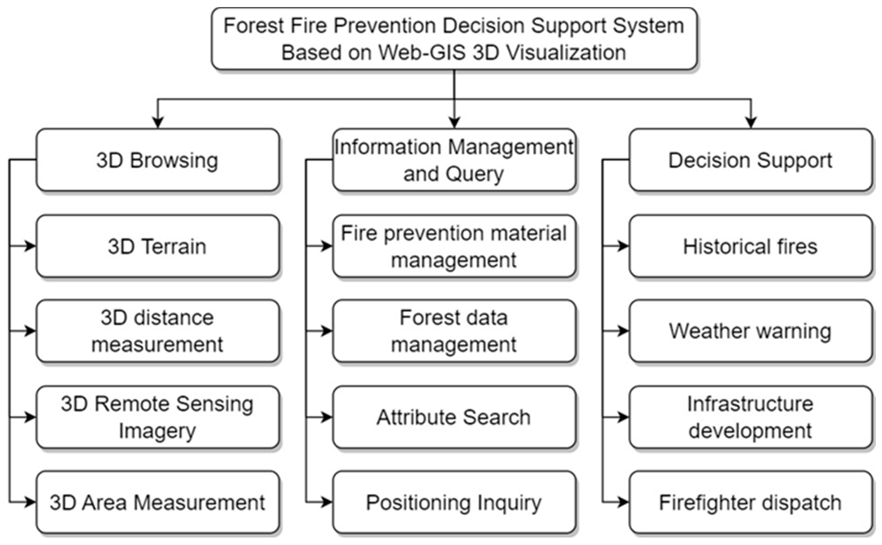
The system is designed to enable relevant departments and users to monitor and respond to forest fires effectively, aiming to mitigate the impact on humans and the environment (
Figure 2). Its key functionalities include the following:
Three-Dimensional Visualization: This feature transforms digital elevation data into vivid 3D visual representations, allowing commanders to gain a comprehensive and precise understanding of forest terrain, topographical variations, and vegetation density. Enhanced measurement capabilities for distance and area aid in accurately assessing potential fire spread directions and extents, facilitating the development of efficient and precise firefighting strategies.
Customizable Integration of Multi-Source Data: The system allows for the superimposition of various layers, including transportation networks, land usage, and forest types, supporting layer-specific computations and analyses. Integration with raster imagery layers enables access to real-time or recent remote sensing images of the work area, including multispectral and infrared imagery. This feature aids users in identifying land types and comprehending the actual topography of the area through the synergy of RS imagery and 3D terrain.
Comprehensive Database and Management Tools: The system includes robust database and management tools for efficient handling and querying of fire prevention resources. It encompasses detailed information about entities and individuals engaged in forest management, emergency response, and volunteer fire prevention activities, including contact details and responsibilities. Additionally, it catalogs resources for forest fire prevention, such as personnel, fire engines, firefighting equipment, aircraft, and helicopters.
2.3. Preparation of Data
In accordance with the identified requirements, the system necessitates the following data categories:
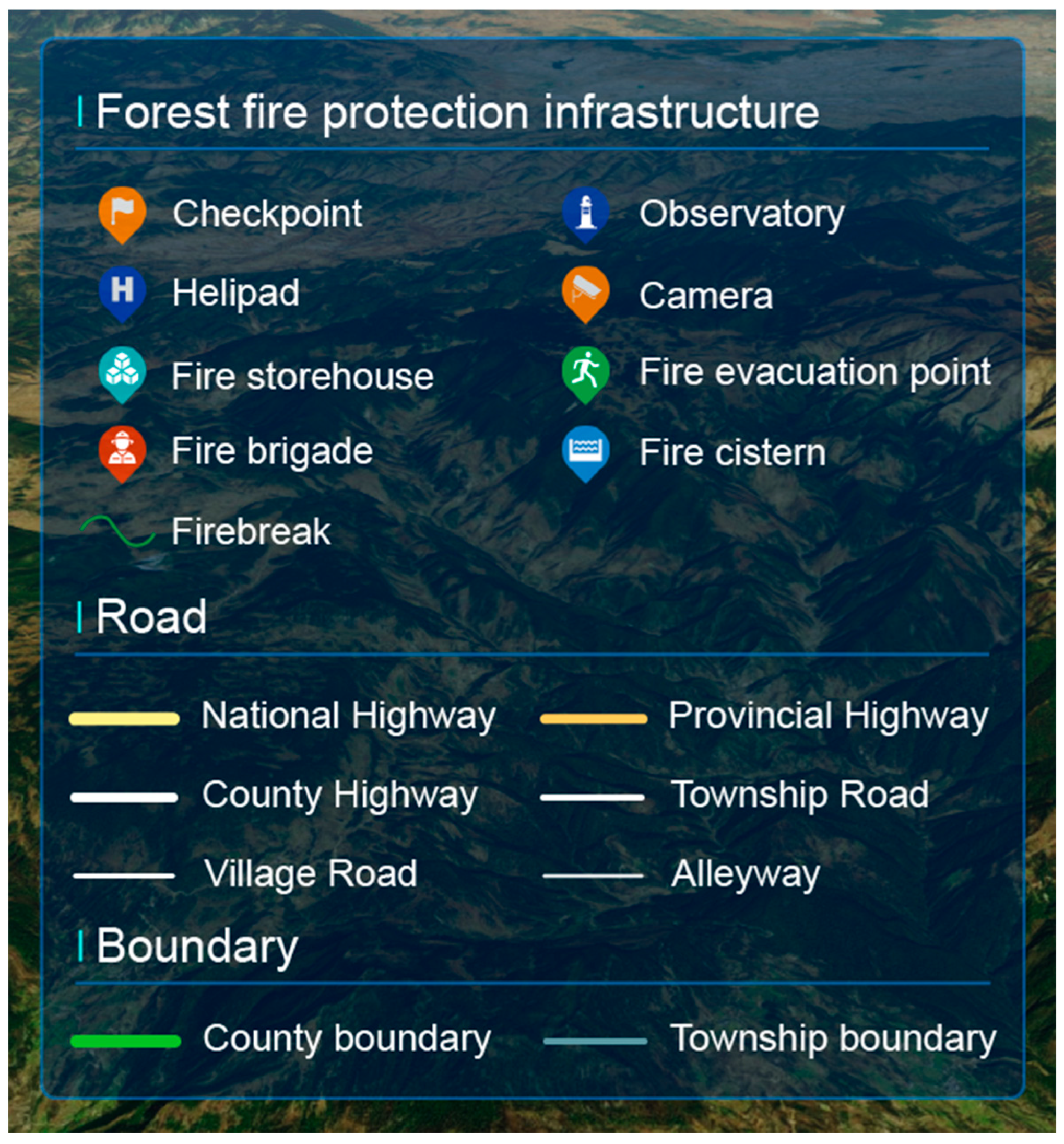
The vector data employed in this research encompass basic geographic data, forest resource data, and specialized data for forest fire prevention. The basic geographic data include elements such as administrative boundaries, roads, rivers, and settlements. Forest resource data comprise field survey information like species of trees, age of trees, and characteristics of forest stands. The thematic data for forest fire prevention detail locations of fire prevention and suppression facilities within the study area, including checkpoints, fire evacuation point, fire storehouse, fire cistern, and camera surveillance systems (
Table 1).
- 2.
Raster Data
For 3D terrain, the system utilizes 3D Tiles format derived from 12.5 m resolution Digital Elevation Model (DEM) data, collected by Japan’s ALOS satellite. Regarding RS imagery, it includes both online and offline modalities. The online imagery comprises Tianditu online map with a 2 m resolution, while the offline imagery incorporates Sentinel-2 data with a 15 m resolution (
Table 2).
2.4. System Development and Technical Implementation
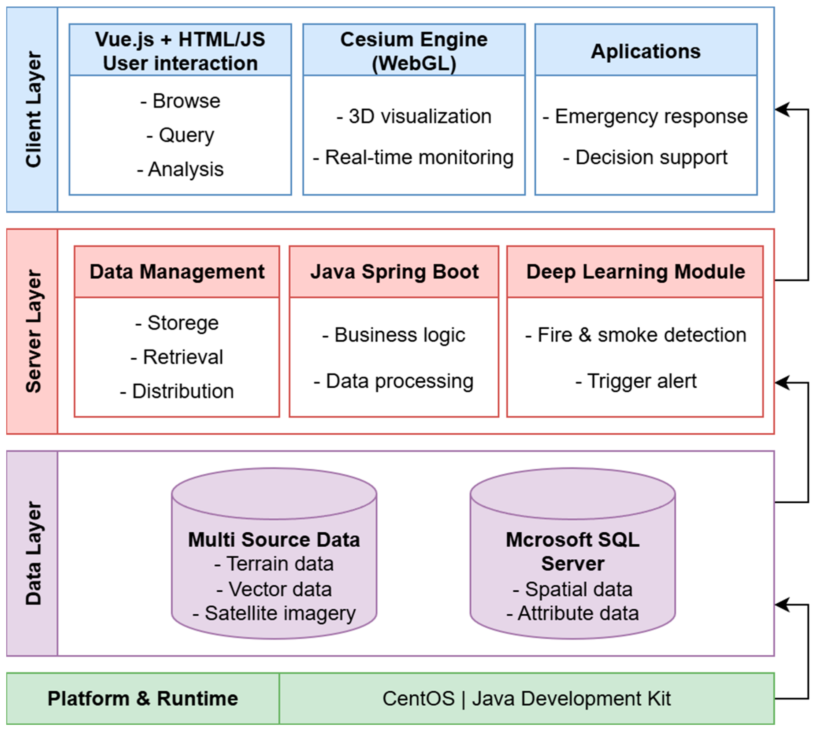
The development of the Web-GIS-based 3D visualization platform employed a structured technical approach to overcome the limitations of traditional GIS in forest fire management. The entire system was built on the CentOS operating system using the Java Development Kit (JDK).
The process began with the efficient transformation and integration of multi-source data (including satellite imagery, terrain data, and meteorological information) into 3D data formats, tackling the challenges of managing large-scale scenarios and extensive datasets. All spatial and attribute data were stored and managed within a Microsoft SQL Server database.
Subsequently, a streamlined 3D Web-GIS platform was developed leveraging a modern technology stack. The back-end was constructed using the Java Spring Boot framework to create a set of RESTful microservices, which handle business logic, data processing, and API provisioning. The front-end was developed with the Vue.js framework, integrating the Cesium engine (based on WebGL and JavaScript) for hardware-accelerated 3D globe rendering, and using HTML and JavaScript for UI construction. This implementation resulted in a system characterized by its cross-platform compatibility and high efficiency, eliminating the need for supplementary software or plugins.
A critical component of the system’s real-time monitoring capability is a deep learning-based image recognition module. A YOLO11 model was trained to automatically detect fire and smoke signatures within video streams from surveillance cameras [
26]. This model was integrated into the back-end microservices architecture, enabling automated alert triggering upon visual confirmation of potential fire incidents. To balance detection speed with accuracy, the model was fine-tuned from the YOLO11 Medium (YOLO11m) pre-trained model. Training was conducted using the FASDD_CV dataset, a large-scale, publicly available benchmark for flame and smoke detection [
27]. Its heterogeneous image characteristics and varying resolutions support robust real-world model development.
The system’s architecture is categorized into three primary layers as per the layered design principle: the Data layer, Service layer, and User layer. The data layer forms the base, tasked with storing critical data such as 3D terrain, raster images, and spatial vectors, organized within the file system to serve as a data source for the Web server. It also enables data updates, deletions, and other management functions. The service layer, functioning as the system’s nucleus, manages and processes spatial information, encompassing tasks like data storage, organization, distribution, retrieval, and processing, thereby ensuring efficient and reliable data handling. At the apex is the user layer, primarily comprising browser applications, offering an intuitive and visual interaction environment. Users engage with the system through this layer, executing various functions including query, analysis, monitoring, and emergency response. This layer’s design focuses on user-friendliness and accessibility, facilitating efficient use by individuals of varying technical expertise. Collectively, this layered architecture not only streamlines data management and processing but also boosts the system’s adaptability and scalability, equipping it to meet the dynamic demands of forest fire prevention management (
Figure 3).
The completed platform facilitates real-time data processing and integration, enabling immediate access to and analysis of up-to-date forest fire data. Furthermore, an intuitive user interface was designed to streamline data querying and visualization analysis, making the system accessible and manageable for non-specialist users. Finally, the system was optimized for efficient functioning across various mobile devices.
3. Results
3.1. Integrated System Functionality
This section summarizes the core functionalities of the proposed Web-GIS system, including 3D visualization, information query, integration of multi-source data, proximity search, and 3D measurement capabilities. Together, these modules highlight the system’s practical utility for supporting forest fire prevention.
3.1.1. Three-Dimensional Terrain Simulation
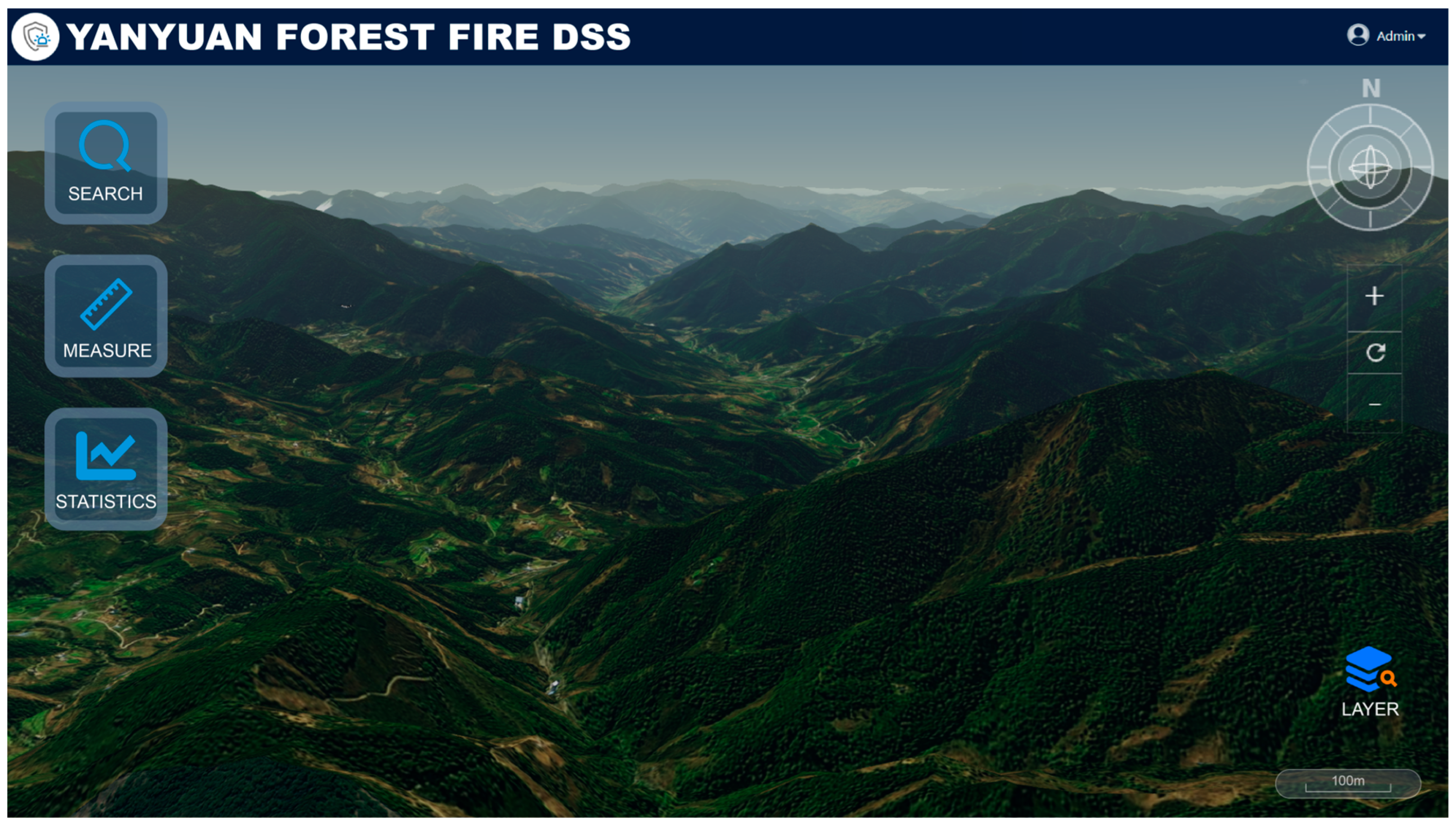
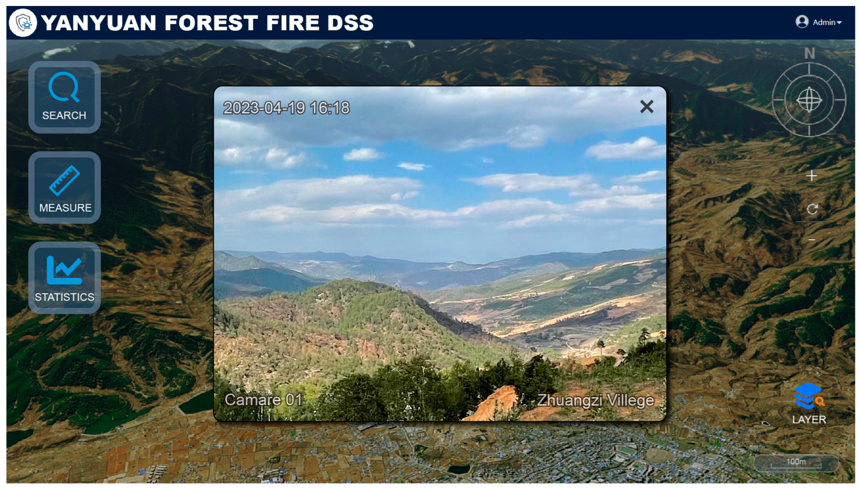
The system utilizes the Cesium engine, creating an effective data visualization platform that capitalizes on WebGL hardware acceleration. This setup enables dynamic rendering of 3D Earth models, excels at the efficient portrayal of multi-source data and facilitating 3D visualization of dynamic time-series data. Furthermore, the platform skillfully simulates dynamic geographical elements, such as sunlight, atmospheric conditions, clouds, fog, and various terrain features. It should be emphasized that the system was originally developed for Chinese users, with its default interface in Chinese. For demonstration purposes in this paper, an English version of the interface has been prepared (
Figure 4).
The system’s functionality can be expanded via third-party plugins, allowing it to support a range of 3D data types. These include terrain, imagery, point cloud/oblique imagery, 2D vector surface data, and Building Information Modeling (BIM) data. It is adept at reorganizing and redefining each data format, converting them into the 3DTiles format, thereby enhancing its data processing versatility and ease of use. These integrated features create a solid technical foundation for managing and displaying complex 3D geographic environments. This capability is invaluable for precise and comprehensive forest fire monitoring and analysis, offering significant support in forest fire management efforts.
3.1.2. Information Query Function
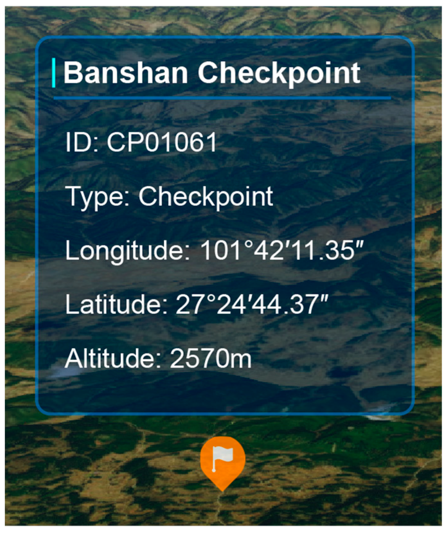
The Information Query module serves as a crucial feature of this system, providing various querying methods for users to access and display key information. Users can utilize this module to determine the names and geographical coordinates of any target on the map. By clicking on these points of interest on the map, an interactive pop-up window is activated, revealing detailed information about the location. This includes specifics such as material inventory, fire prevention teams, and additional fire prevention and suppression resources. Moreover, it provides relevant geographical information, including forest resources, types of combustibles, roads, water sources, elevation, and topographical features (
Figure 5).
The system enhances user experience and query efficiency by offering three spatial positioning methods:
- 1.
Coordinate Positioning: This feature allows users to input specific coordinates, either in latitude and longitude or in Cartesian plane format. Upon entering these coordinates, the system automatically adjusts the current view to center on the specified location.
- 2.
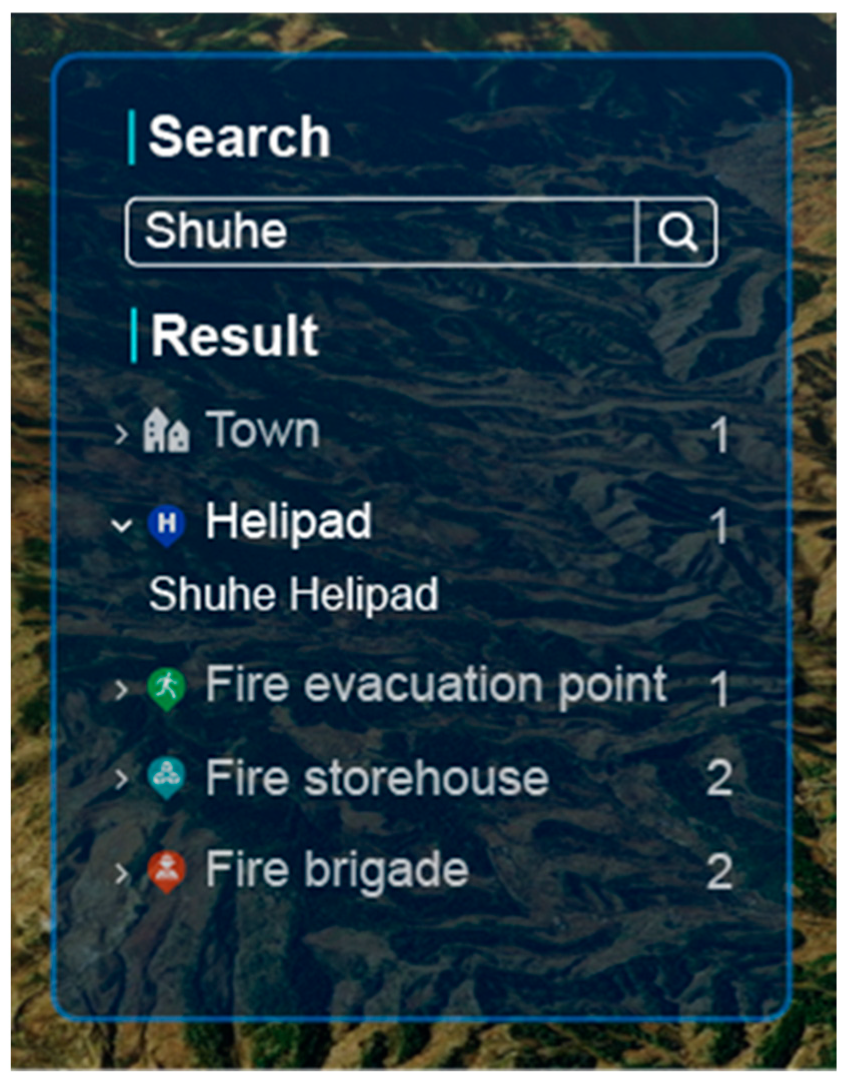
Place Name Search: Users can search for a location by entering its name. The system then performs a thorough search within its place name database, displaying a list of all relevant matches. From this list, users can select any place name for quick and accurate map positioning (
Figure 6).
- 3.
Organizational Tree-Based Positioning: Additionally, the system provides a feature for positioning any entity within Yanyuan County through an organizational tree menu. Users can navigate through this tree structure to select a specific entity for map positioning.
These query and positioning tools collectively enhance the efficiency of information retrieval. They are crucial in facilitating swift emergency response and supporting informed decision-making in critical situations.
3.1.3. Integration of Multi-Source Data
The system is adept at integrating information from diverse sensors and data sources, effectively enhancing its sensitivity, precision, reliability, and response speed. This capability not only aids in the system’s continuous upgrading and scaling but also strengthens its adaptability and dependability. It accommodates various data formats, encompassing widely used specifications like Web Map Service (WMS), Web Map Tile Service (WMTS), Tile Map Service (TMS), and standard vector or raster formats, ensuring comprehensive data compatibility (
Figure 7).
3.1.4. Proximity Search Function
In the context of forest fire emergencies, the proximity search function is a key feature for rapidly accessing essential information. This function enables users to swiftly locate and acquire contact details of the nearest fire stations, fire monitoring towers, and other crucial facilities, thereby aiding in immediate response (
Figure 8).
This feature leverages GPS integration or user-input location data. It compares the user’s current location with the facility data stored in the database, automatically organizing and presenting facilities based on their proximity to the user. This automated procedure significantly reduces the time required to collate information, enhancing the efficiency of emergency response.
Moreover, the proximity search function offers real-time support to firefighting and rescue teams on-site. It provides vital information, such as the locations of the closest water sources and shelters. This is instrumental in formulating more effective strategies and allocating resources efficiently during pivotal fire-fighting and rescue missions.
3.1.5. Three-Dimensional Measurement Capability
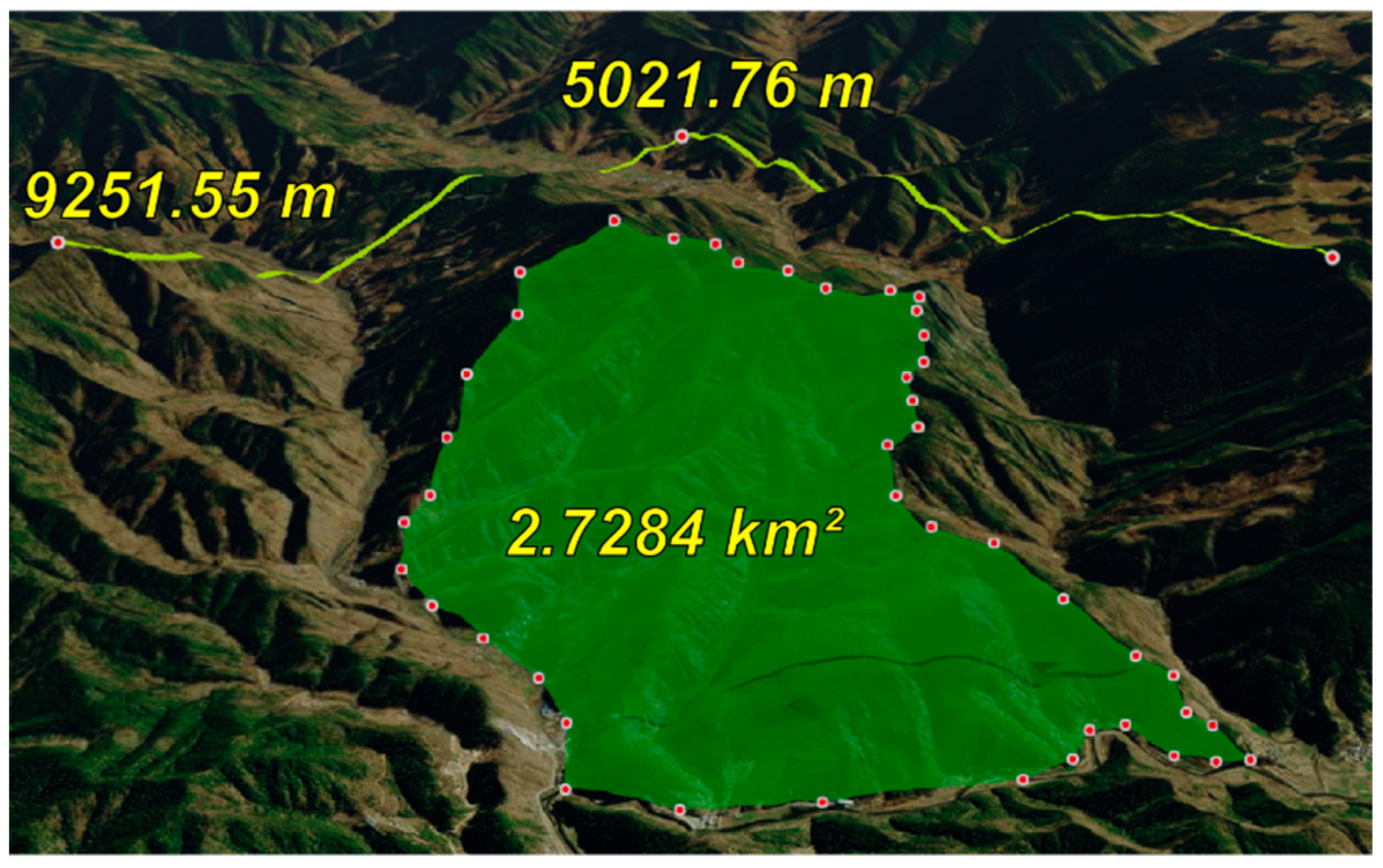
A distinctive feature of this system is its incorporation of a three-dimensional terrain model. This feature provides a level of detail surpassing that of traditional flat GIS, enabling a more accurate representation of complex terrains, such as forested and mountainous regions. Conventional 2D GIS measurements often encounter challenges with obstructions and perspective distortions, which can lead to inaccuracies. In contrast, 3D spatial measurements effectively overcome these limitations. The measurement tools in this system closely follow the contours of the terrain, circumventing visual obstacles to provide precise and reliable measurements (
Figure 9).
Furthermore, the 3D measurement capability enhances spatial awareness and offers crucial dimensional data, such as elevation and slope angles. These details are vital for understanding and assessing forest fire risks. For instance, in fire spread prediction and firefighting strategy formulation, the comprehensive terrain data provided by 3D measurements furnish decision-makers with a more profound insight into potential fire spread trajectories and velocities. This depth of information is instrumental in making informed decisions during critical fire management situations.
3.1.6. Remote Monitoring
The system utilizes streaming protocols to integrate remote video surveillance, enabling real-time monitoring of forest fires (
Figure 10). To automatically analyze these video streams, a dedicated deep learning model was developed and deployed for real-time detection of flame and smoke signatures. This model is built on the YOLO11 object detection architecture, chosen for its optimal trade-off between inference speed and detection accuracy [
26].
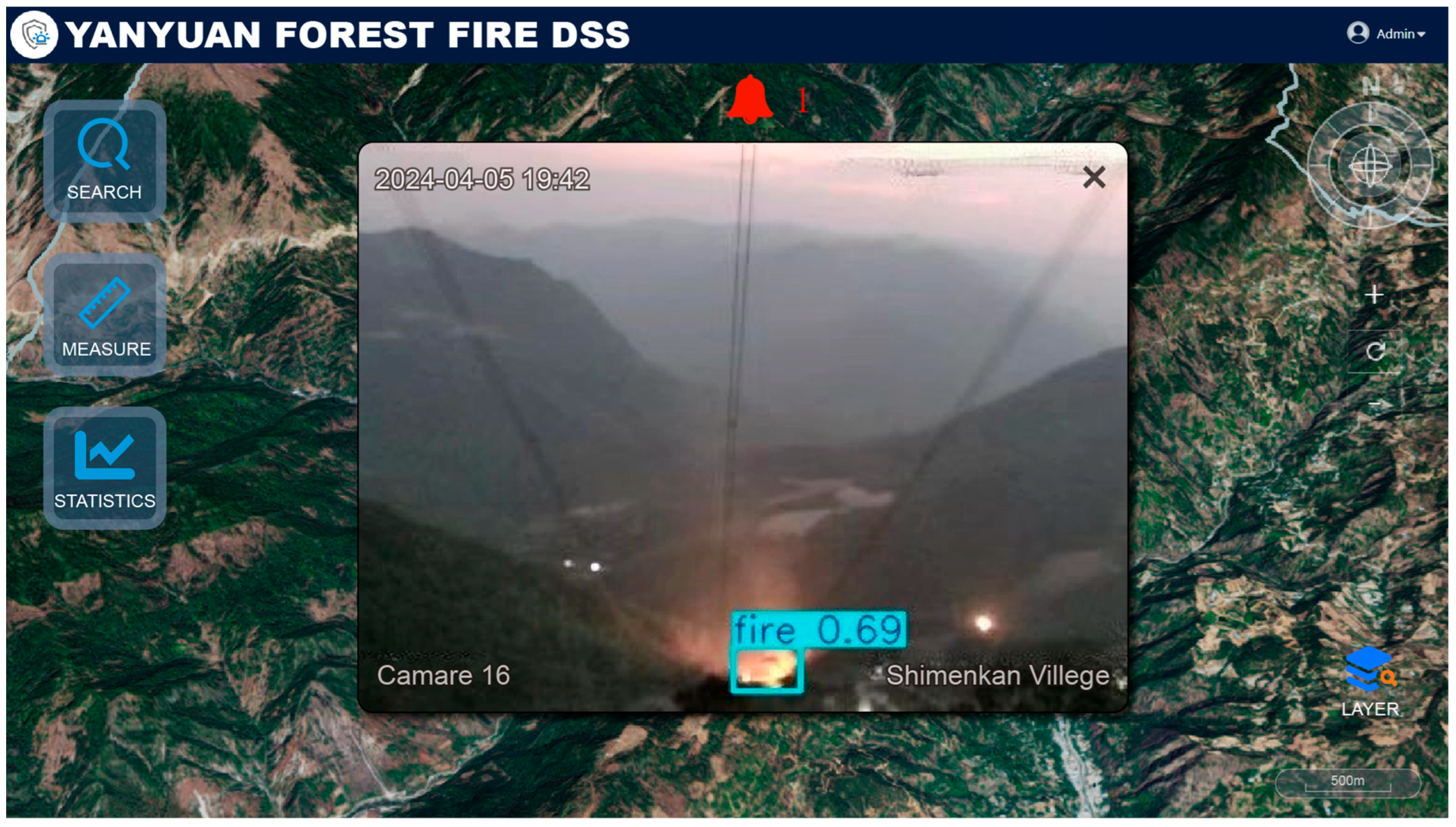
On the reserved test set, which included complex scenarios reflecting the terrain and vegetation of Yanyuan County, the model achieved an precision of 82.4% and a recall of 73.7%, indicating strong reliability for early fire warning. The model was deployed on a central server equipped with an NVIDIA RTX 4070 Ti SUPER GPU, where it processed video streams at an average rate of 25 FPS per stream, effectively supporting real-time analysis across multiple video feeds. This server-side deployment strategy facilitates system maintenance while ensuring stable and reliable performance (
Figure 11).
Once a potential fire is detected at a confidence threshold greater than 0.25, the system outputs the corresponding camera ID and marks its location on the Web-GIS 3D map with an alert icon, prompting staff to conduct further assessment and verification. Experimental results demonstrate that the system’s single-frame response time for video streams remains below 50 ms (
Figure 12).
3.2. Cross-Platform Compatibility
This system is designed with a strong focus on cross-platform compatibility, ensuring its effective functionality across diverse operating systems and devices. Utilizing a cross-platform framework, it facilitates smooth operation across various browsers, independent of specific hardware or operating systems. This approach not only simplifies system access and usability but also significantly increases its adaptability in different settings. Furthermore, the system is optimized for mobile access, including smartphones and tablets, empowering users with real-time system interaction in field settings, which notably enhances field operational efficiency. Overall, the cross-platform capabilities of the system offer substantial convenience, assuring consistent performance and reliability whether used on desktop computers in offices or on mobile devices in remote locations, thereby meeting the multifaceted requirements of forest fire prevention management across various contexts (
Figure 13).
3.3. Response Efficiency Comparison
To evaluate the operational response efficiency of the proposed Web-GIS-based three-dimensional visualization decision support system, a simulated forest fire emergency drill was conducted in Yanyuan County, Liangshan Prefecture, Sichuan Province. This exercise focused on comparing the performance of the proposed system with that of the traditional forest fire monitoring platform previously employed by the Forestry Department of Yanyuan County, with particular attention to response time and ease of operation.
The legacy monitoring platform used in Yanyuan County was built on two-dimensional maps, supported by manual data compilation and inter-agency communication. While it provided basic functionalities such as fire point logging and early warnings, it lacked system interoperability and offered limited spatial representation, constraining its ability to support real-time 3D situational awareness and unified emergency command. In contrast, the Web-GIS system developed in this study integrates diverse spatial data—including three-dimensional terrain, real-time video feeds, road networks, and infrastructure—and is built on a browser/server (B/S) architecture. It requires no client-side installation and supports seamless access across multiple platforms and devices.
Using the duration from alarm receipt to the generation of a response plan as the principal performance metric, the results (
Table 3) indicate that the average response time using the legacy platform was 19 min, whereas the proposed system reduced this to 12 min, yielding a 37% improvement in response efficiency. Furthermore, all five forestry personnel participating in the evaluation reported that the system’s intuitive 3D visualization and real-time situational awareness under complex terrain conditions significantly enhanced their decision-making capability. The system also facilitated smoother inter-agency coordination, substantially mitigating delays caused by communication inefficiencies.
4. Discussion
The development of forest fire decision support systems has traditionally relied on conventional C/S or 2D B/S architectures, which often lack spatial depth, real-time integration, and broad accessibility [
15,
16,
20]. This study presents a novel Web-GIS 3D visualization system that integrates multi-source geospatial data, real-time video monitoring, and deep learning–based fire detection within a browser-based, cross-platform framework. The system marks a departure from traditional approaches and introduces several conceptual, technical, and practical advancements.
4.1. System Performance and Practical Validation
Beyond technical implementation, the system’s effectiveness was evaluated through operational deployment. A simulated emergency drill in Yanyuan County showed a 37% reduction in average response time compared to the legacy 2D GIS platform previously used by local authorities (
Table 3). This significant improvement can be attributed to several key features: the intuitive 3D visualization of terrain and resources, which accelerates spatial comprehension; the integration of real-time video feeds for immediate situational awareness; and the automated alerts triggered by the YOLO11 detection model. Qualitative feedback from users highlighted enhanced ease of use and improved interoperability across different agencies. These results demonstrate the system’s success in addressing critical shortcomings of traditional systems, such as manual data integration and fragmented workflows, translating technical innovation into tangible operational gains.
4.2. Comparative Analysis and Novelty Within the Field
This system introduces several advancements that distinguish it from prior approaches. Unlike earlier systems such as the NFDRS and CFFDRS, which rely mainly on point-based physical models with limited spatial context, our platform embeds decision-support within an interactive 3D environment. This enables a more intuitive understanding of terrain-driven fire behavior, vegetation density, and resource distribution.
Technical Implementation: Built on a modern, reproducible stack (Java Spring Boot, Vue.js, Cesium, SQL Server), the system employs a B/S architecture that eliminates client-side installations and ensures cross-platform accessibility. The use of 3DTiles enables efficient terrain and imagery streaming, balancing performance with bandwidth constraints.
Functional Integration: The system moves beyond prior 2D Web-GIS applications or offline 3D models by enabling real-time interaction. Its most significant methodological innovation is the integration of live video streams with a trained YOLO11 model, effectively bridging computer vision with spatial decision support in an operational setting. Compared to desktop-based or plugin-dependent systems, this integrated, browser-based approach lowers deployment costs and increases accessibility, making it suitable for broad adoption, including in resource-limited contexts.
4.3. Limitations and Future Work
Despite its strengths, the system’s performance faces two primary limitations: hardware dependency and network connectivity. The client-side 3D visualization imposes significant graphical processing demands, which may lead to suboptimal performance on older hardware. More critically, core functionality depends on stable network connectivity—a persistent challenge in remote areas. While practical solutions were implemented (e.g., wireless bridges for data acquisition; a PWA design for limited client-side offline functionality), full real-time features remain network-dependent, requiring a minimum sustained uplink bandwidth of 2–4 Mbps per video stream.
To address these issues, future work will focus on two tracks: (1) expanding PWA capabilities to develop a robust offline mode for operations in network-blind spots, and (2) integrating advanced fire spread simulations and climate adaptation models to strengthen predictive analytics and long-term forest resilience planning.
4.4. Broader Implications for Sustainable Forest Management
The implications of this system extend beyond immediate operational improvements. Ecologically, it supports forest resilience by enabling faster, more targeted fire responses, thereby reducing biomass loss and carbon emissions. Socially, its intuitive design lowers technical barriers, fostering inclusive participation in fire management and enhancing community resilience. Economically, the potential reduction in emergency response costs and fire-related damages contributes to the long-term economic sustainability of forest resources. Collectively, these benefits align with and advance the broader objectives of sustainable forest management and climate adaptation strategies.
5. Conclusions
Big data and lightweight Web-GIS technologies are unlocking the transformative potential for advancing forest fire prevention and sustainable forest management. This study designed and implemented a decision support system that leverages these technologies by integrating multi-source data—including 3D terrain models, real-time video streams, and deep learning-based automated detection—into a unified, cross-platform Web-GIS environment. The case study in Yanyuan County demonstrated that this 3D visualization-based approach significantly enhances situational awareness and operational coordination, leading to a 37% improvement in emergency response speed and providing a more intuitive tool for field personnel.
In conclusion, this research validates the efficacy of integrating real-time monitoring, AI analytics, and 3D Web-GIS visualization to create a more responsive and intelligent framework for forest fire management. The system presents a practical solution for high-risk regions and contributes a replicable model for modernizing ecological governance.
Looking ahead, future efforts will build upon this foundation to improve the precision of detection modeling, incorporate climate projections for long-term resilience planning, and strengthen fire spread simulation capabilities. These directions will further support the development of comprehensive, data-informed strategies tailored to the challenges of a changing climate.

