Article

Spatial and Temporal Distribution Characteristics and Influencing Factors of Red Industrial Heritage in Hebei, China

by
Xi Cao
and
Xin Liu
*
School of Architecture and Art Design, Hebei University of Technology, Tianjin 300132, China
*
Author to whom correspondence should be addressed.
Sustainability 2025, 17(16), 7532; https://doi.org/10.3390/su17167532
Submission received: 8 July 2025 / Revised: 14 August 2025 / Accepted: 17 August 2025 / Published: 20 August 2025
(This article belongs to the Special Issue Cultural Heritage Conservation and Sustainable Development)

Abstract

Red industrial heritage is a crucial component of global socialist industrial civilization, embodying both industrial memory and revolutionary spirit. However, its preservation faces significant challenges, including insufficient policy attention, homogenized revitalization models, and a lack of systematic research. This study uses Hebei Province, a key region where modern industry and revolutionary history intersect, as a case study. By employing Geographic Information System (GIS) spatial analysis and historical geography, the research explores the spatiotemporal patterns and underlying factors that influence the distribution of red industrial heritage. The findings reveal: (1) the spatial distribution is irregular, exhibiting concentration, with high density in the central and southern parts of Hebei, while the northern and eastern areas are more dispersed; (2) The spatiotemporal evolution aligns with significant historical events; (3) The distribution pattern is shaped by multiple factors, with the dynamics of modern Chinese warfare and historical policies serving as the primary driving forces, interacting with natural geographical factors. This study enhances our comprehension of the significance of red industrial heritage and, based on its spatiotemporal variations, proposes a tiered, sustainable preservation strategy. It provides valuable insights into the preservation of socialist industrial heritage both in China and globally.

1. Introduction

Industrial heritage serves as both a material and immaterial witness to the global industrialization process [1]. As a key vehicle for the inheritance of industrial civilization, its preservation has shifted from preserving individual buildings to exploring multiple values [2,3,4,5]. The Nizhny Tagil Charter, adopted by the International Committee for the Conservation of the Industrial Heritage (TICCIH) in 2003, proposed evaluation criteria based on historical, technological, social, architectural, and scientific values [6]. While providing theoretical support for revitalizing Western industrial heritage, such as Germany’s Ruhr region and Britain’s Ironbridge Gorge, it has exhibited certain limitations in explaining the political correlation characteristics within the industrialization process of socialist states [7]. As a late-industrialized nation [8], China’s unique revolutionary and developmental history has given rise to a distinct category of heritage, namely red industrial heritage. Red industrial heritage is a modern industrial heritage system that was formed under the leadership of the Communist Party of China during the country’s modernization process. It also constitutes a significant component of the industrial heritage of the global socialist movement [9,10]. Compared to general industrial heritage, red industrial heritage not only records innovations in industrial technology but also carries the revolutionary spirit and the memory of social transformation during specific historical periods, thereby enriching the connotations of international industrial civilization. Its core characteristics can be described across the following four dimensions:
  • Historical Dimension: The history spans from the founding of the Communist Party of China in 1921 to the early industrialization period of the People’s Republic of China.
  • Material Dimension: This includes physical remains such as factories, mines, and production equipment, as well as non-material elements like related technical archives.
  • Connotative Dimension: It witnesses major turning points or significant events in the Party’s history, playing a key role in the Party’s leadership in the country’s modernization.
  • Value Dimension: It holds historical value of the Party, along with multiple other value dimensions, including architectural aesthetic value, locational value, historical value, regional cultural value, and value in the history of technology.
Therefore, the preservation of red industrial heritage not only sustains the industrial memory of socialist nations but also injects new momentum into the sustainable development of global industrial heritage through expanded value dimensions, shared technical experiences, and innovative models.
In recent years, China has actively explored the preservation of red industrial heritage. Multiple agencies, including the National Cultural Heritage Administration and the Ministry of Industry and Information Technology, have collaborated on nationwide surveys and identification. The third batch of the China Industrial Heritage Protection List, published in September 2023, focused on “Red Industrial Heritage” within China’s modernization journey, listing 100 significant sites and further clarifying conservation priorities [11]. In June 2024, the event “Marks of the Republic—The Light of Industry Illuminates China” was held with the goal of further exploring the significance of industrial heritage [12]. Simultaneously, Chinese scholars have conducted extensive research on different facets of red industrial heritage. Their studies cover areas such as strategies for updating red industrial heritage [13], spatial optimization [14], adaptive reuse [15], the implementation of its educational role [16,17], and assessments of its current condition [18]. These studies have explored heritage characteristics, architectural conservation, spiritual inheritance, value assessment, and tourism development, providing valuable insights for the sustainable development of red industrial heritage.
The preservation of red industrial heritage currently faces numerous challenges. In practice, existing policies and regulations do not establish specific protection standards for red industrial heritage. Local governments often apply general industrial heritage or cultural relics regulations [19], neglecting the unique “red gene” of these sites. During the process of adaptive reuse, governments and investors tend to focus on economic value, overlooking the transmission of revolutionary spirit. As a result, many significant sites, such as the Lanzhou Petroleum Machinery Factory and the Tianjin Alkali Plant [20,21], have been demolished due to urban planning requirements. Preserved projects are often transformed into “cultural and creative industrial parks” or “industrial-style commercial complexes,” with some directly emulating the operational model of Beijing’s 798 Art District. These transformations overemphasize “industrial aesthetics” while downplaying the red heritage, leading to insufficient exploration of the red theme and homogenized revitalization models. From an academic perspective, there has been limited exploration into the political attributes of industrial heritage in socialist states [22]. European scholars have only occasionally addressed the ideological expressions of Cold War-era industrial heritage [23,24,25]. Domestic research often simplifies red industrial heritage as an appendage to revolutionary sites or ordinary industrial heritage, severing the connection between its technological contributions and political attributes. Studies on revitalization primarily focus on case analyses of individual heritage sites, lacking systematic research on the spatiotemporal distribution patterns and underlying drivers at the regional level.
Hebei Province is situated in the northern region of the North China Plain, with the Bohai Sea to the east, the Taihang Mountains to the west, and the Yanshan Mountains to the north, encircling Beijing and Tianjin. This region exemplifies the convergence of modern industrial development with China’s revolutionary history (Figure 1). As a vital industrial support zone during the War of Resistance Against Japanese Aggression, the Liberation War, and a core area for industrialization in the early People’s Republic of China, it possesses particularly rich red industrial heritage resources. It densely hosts wartime factories from the Jin-Cha-Ji Border Region during the War of Resistance Against Japanese Aggression, industrial bases from the Liberation War period, Soviet-aided “156 Projects” from the First Five-Year Plan, and industrial projects from the Third Front Construction. Notable examples include the Jingxing Coal Mine Red Heritage Cluster, the Huhushui Hydropower Station (the PLA’s first hydroelectric power station), and the North China Pharmaceutical Factory, which ended China’s reliance on imported penicillin, and are distinguished by their combination of revolutionary significance and industrial breakthroughs. Currently, Hebei Province is conducting surveys and preservation efforts for industrial heritage and revolutionary relics. However, comprehensive studies on the evolutionary mechanisms of red industrial heritage are still lacking. This work utilizes Hebei as a case study, employing multi-source data analysis and model construction to investigate the spatiotemporal distribution characteristics of red industrial heritage and its influencing elements. The goal is to offer robust support for a thorough understanding of the historical significance of red industrial heritage and to develop scientifically informed preservation strategies. Additionally, it calls for greater global recognition of the unique value of red industrial heritage, paving the way for future development in related conservation efforts.
This study focuses on the red industrial heritage of Hebei Province and addresses the following questions: (1) spatial distribution patterns and their directional characteristics; (2) how the spatiotemporal evolution trajectories and how they respond to significant historical events; (3) the influence of the interplay between natural and human factors on the distribution of heritage sites. To answer these questions, the study employs spatial analysis using Geographic Information Systems (GIS) and historical geography methods, constructing a “Pattern–Process–Mechanism” research framework. The innovations of this study are highlighted in three key areas:
  • Systematically analyzing the spatial regulatory role of policy orientation on Red Industrial Heritage distribution by combining qualitative and quantitative research;
  • Revealing the dynamic coupling mechanism between heritage distribution and industrialization processes through the spatial reconstruction of multi-source historical geographical data (topography, transportation, policy texts);
  • Proposing tiered conservation strategies based on spatiotemporal differentiation patterns, promoting a shift from “passive rescue” to “proactive planning” in heritage preservation, and fostering its sustainable development.
This paper is structured as follows: Section 1 provides an overview of the research background, current problems, study area overview, research methodologies, and innovations. Section 2 section details data sources, database construction, and GIS analysis techniques. Section 3 presents the findings on spatial distribution, spatiotemporal evolution, and driving factors, both from a typological and holistic perspective. In Section 4, these findings are interpreted, and recommendations for preservation and utilization are offered, along with a discussion of the study’s limitations. Finally, Section 5 summarizes the results and proposes directions for future research.

2. Research Methods

2.1. Data Collection

This study focuses on 80 red industrial heritage sites in Hebei Province. The data sources include the National Industrial Heritage List (batches 1–6) published by the Ministry of Industry and Information Technology of the People’s Republic of China; the China Industrial Heritage Protection List (batches 1–3) jointly released by the China Urban Planning Society and the National Academy of Innovation Strategy; the Hebei Provincial Industrial Heritage List (batches 1–2) published by the Industry and Information Technology Department of Hebei Province; industrial building sites from the provincial, municipal, and county-level cultural heritage protection units announced by the People’s Government of Hebei Province; the National Key Cultural Relics Protection Units List (batches 1–8) published by the State Council of the People’s Republic of China; industrial buildings in historic buildings listed by the Hebei Provincial Department of Housing and Urban–Rural Development and the Ministry of Culture and Tourism; industrial sites from the Hebei Province Unmovable Revolutionary Cultural Relics List (batches 1–2) published by the Hebei Cultural Relics Bureau; as well as literature and field survey data collected by the author. Based on the meaning and core characteristics of red industrial heritage, 80 heritage sites were identified. Beyond attribute information, such as name, construction time, and function, precise coordinates of the sites were extracted using the Baidu Maps API. All information was categorized in Excel 2016, and a point dataset was established in ArcGIS 10.8 to produce the spatial distribution map of red industrial heritage in Hebei Province.

2.2. Research Design

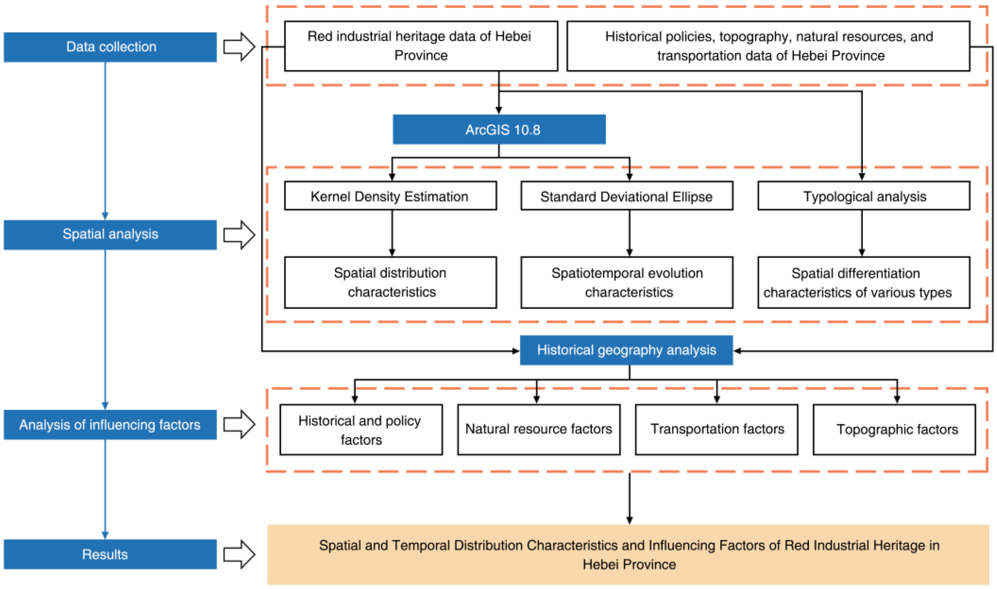
This research aims to examine the distribution patterns of red industrial heritage in Hebei Province and the underlying factors influencing their development. Firstly, we gathered attribute data and geographic coordinates for the 80 red industrial heritage sites in Hebei Province and imported them into the ArcGIS 10.8 platform. These data were integrated with fundamental geographic information, including the administrative boundaries of Hebei Province, elevation data, the railway network (mainlines from 1980), and the distribution of mineral resources, resulting in a multi-source database. Secondly, based on relevant historical and literature research [26,27], the red industrial heritage sites in Hebei were classified and divided into historical phases. Utilizing GIS spatial statistical analysis methods [28,29,30], such as spatial autocorrelation analysis, kernel density estimation, standard deviational ellipse and mean center, the study investigated the overall distribution characteristics of heritage sites, the variations in distribution across different historical periods, and the trends in the movement of distribution centers. Finally, the study systematically analyzed how historical policies, natural resources, transportation, and topographic factors in Hebei Province have influenced the distribution of red industrial heritage. The research framework is presented in Figure 2.

2.2.1. Kernel Density Estimation

Kernel density estimation is used to calculate the spatial distribution characteristics of heritage sites across the entire area [31,32]. A higher kernel density value indicates a greater concentration. It is obtained by means of Equation (1).
f x = 1 n h i = 1 n k x x i h
In the formula, f x represents the kernel density estimate at heritage site x ; n is the total number of heritage sites; h is the bandwidth; and x x i is the distance between the estimation point x and the heritage site x i .

2.2.2. Spatial Autocorrelation Analysis

Spatial autocorrelation analysis is a statistical method used to measure the degree of similarity in attributes of observations at adjacent or nearby locations in geographic space, aimed at identifying patterns of spatial clustering, dispersion, or randomness [33]. In this study, we applied the Global Moran’s I and Anselin Local Moran’s I methods in ArcGIS to analyze the spatial autocorrelation of red industrial heritage sites in Hebei Province.
(1) Global Moran’s I: This is an indicator used to measure global spatial autocorrelation in spatial data [34]. It assesses whether the data exhibit a spatial clustering pattern by calculating the weighted similarity between all spatial units. It is obtained by means of Equation (2).
I = n i = 1 n j = 1 n ω i j x i x ¯ x j x ¯ i = 1 n j = 1 n ω i j i = 1 n x i x ¯ 2
In the formula, I represents the Global Moran’s I value, indicating the global spatial autocorrelation. The value of I ranges from −1 to 1, where I > 0 indicates positive spatial correlation, meaning a clustered distribution; I < 0 indicates negative spatial correlation, meaning a dispersed distribution; and I = 0 indicates no spatial autocorrelation, meaning a random distribution. Significance is determined through a randomization test, with z > 2.58 and p < 0.01 indicating a highly significant result (i.e., the spatial distribution is non-random).
(2) Anselin Local Moran’s I: This method is used to analyze local spatial autocorrelation for each spatial unit [35]. Examining the spatial clustering patterns of red industrial heritage sites in different regions helps to identify local “hotspot” or “coldspot” areas. It is obtained by means of Equation (3).
I i = x i x ¯ S 2 j = 1 n ω i j x j x ¯
In the formula, I i represents the local Moran’s I for the i -th spatial unit, which is classified into four types: high-high clusters (hotspots), high-low outliers, low-high outliers, and low-low clusters (coldspots).

2.2.3. Mean Centre and Standard Deviational Ellipse

The standard deviational ellipse is a spatial statistical method used to characterize the central tendency, dispersion, and directionality of point data [36]. It is defined by basic parameters, including the orientation, major and minor axes, and mean center. This method is employed to examine the spatial clustering patterns of heritage sites and their changes over time [37,38]. The minor axis represents the degree of clustering of heritage sites, while the major axis shows the dominant direction of their spatial distribution. Firstly, the arithmetic mean center is calculated to determine the ellipse’s center, and changes in its position over different historical periods can be analyzed to study the spatiotemporal evolution of heritage sites. It is obtained by means of Equations (4) and (5).
S D E x = i = 1 n x i X ¯ 2 n
S D E y = i = 1 n y i Y ¯ 2 n
In the formula, x i and y i represent the spatial coordinates of each heritage site, while X and Y are the arithmetic mean center, and S D E x and S D E y are the calculated coordinates of the ellipse’s center. The direction of the ellipse is then determined, with the x-axis as the reference, where north is at 0° and rotation is clockwise. It is obtained by means of Equations (6)–(9).
tan θ = A + B C
A = i = 1 n x i ~ 2 i = 1 n y i ~ 2
B = i = 1 n x i ~ 2 i = 1 n y i ~ 2 2 + 4 i = 1 n x i ~ y i ~ 2
C = 2 i = 1 n x i ~ y i ~
where x i ~ and y i ~ are the differences between the mean center and the x and y coordinates, respectively. Finally, the lengths of the x and y axes are determined. It is obtained by means of Equations (10) and (11).
σ x = 2 i = 1 n x i ~ cos θ y i ~ sin θ 2 n
σ y = 2 i = 1 n x i ~ sin θ + y i ~ cos θ 2 n

3. Results

3.1. Spatiotemporal Distribution Characteristics

3.1.1. Historical Phases

The formation and evolution of red industrial heritage in Hebei Province are intricately linked to the advancement of modern industry and revolutionary history. This study categorizes the evolution of Hebei’s red industrial heritage into five stages, based on significant historical events that triggered social change [39,40] (Table 1):
Stage 1 (1861–1911): From the emergence of the Westernization Movement to the overthrow of the imperial system during the Xinhai Revolution. Throughout this era, the Westernization Movement led to the establishment of modern military and civilian industries in Zhili (now Hebei and adjacent regions), including the Kaiping Mining Bureau (established in 1878) and the Shanhaiguan Bridge Factory (established in 1894). These laid the foundation for modern industry in Hebei and nurtured the early working class [41,42].
Stage 2 (1912–1936): From the establishment of the Republic of China until the full-scale outbreak of the War of Resistance Against Japanese Aggression. National industries began to develop along railway lines, with the rise of national capital enterprises such as Daxing Spinning Factory and Nanshan Electric Power Plant. However, the industrial production faced difficulties due to the ongoing warlord conflicts and Japanese invasions.
Stage 3 (1937–1945): From the outbreak of the full-scale War of Resistance Against Japanese Aggression to victory. Hebei, as a core area for resistance warfare in enemy-occupied areas in North China, saw the establishment of military factories, clothing factories, and other wartime industries in the Jin-Ji-Lu-Yu and Jin-Cha-Ji border regions, which produced supplies to support the front lines. Red industrial heritage emerged from the fires of war, forming a unique system.
Stage 4 (1946–1949): From the Liberation War to the establishment of the People’s Republic of China. Liberated areas took over and transformed industrial facilities left by the Japanese puppet regime, such as the Jingxing Coal Mine (liberated in 1947) and the Huhushui Hydropower Station. The “protection of industry and commerce” policy was implemented, allowing enterprises like Daxing Spinning Factory to quickly resume operations and restore industry through “production for front-line support,” thereby providing material supplies for the warfront.
Stage 5 (1950–1978): From the establishment of the People’s Republic of China to the early phase of the reform and opening-up period. This phase saw the establishment of the industrial layout of the new China, driven by the First Five-Year Plan and the Third Front Construction. Soviet-aided projects, such as the Shijiazhuang Thermal Power Plant, the North China Pharmaceutical Factory, and the Third Front military–industrial clusters in the Taihang Mountains, were established, integrating red industrial heritage into the national industrialization strategy and forming an industrial pattern characterized by both a planned economy and wartime preparedness.

3.1.2. Spatial Distribution Characteristics

(1)
Overall Spatial Distribution Characteristics
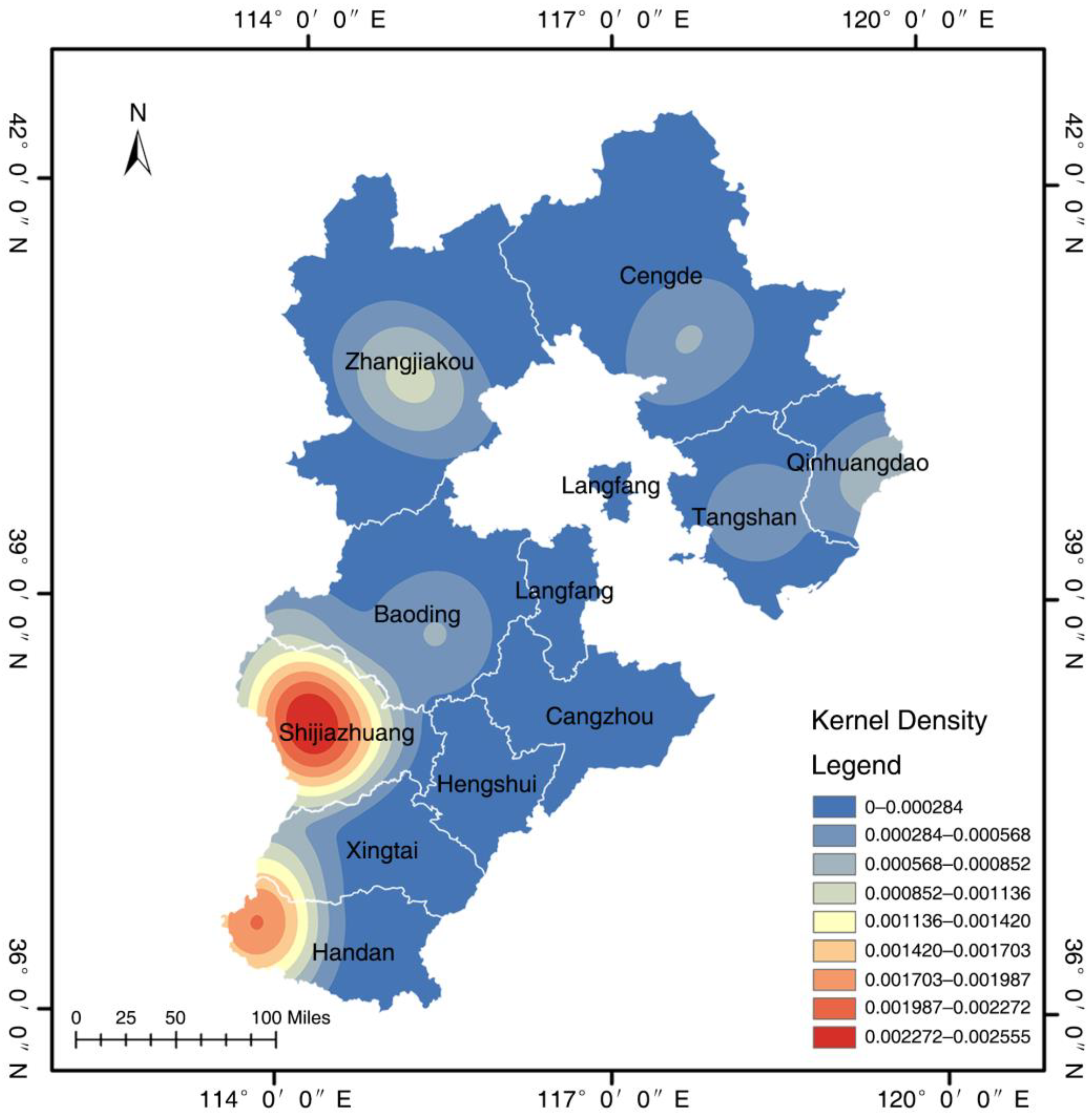
Kernel density analysis in ArcGIS was applied to create a map showing the spatial distribution of red industrial heritage in Hebei Province (Figure 3). The findings reveal significant variations in density. The majority of heritage sites are located in the central and southern regions of Hebei, with two core areas forming around Handan and Shijiazhuang. These areas exhibit high density and a degree of spatial continuity. In contrast, the northern and eastern regions have fewer heritage sites, with a dispersed pattern and local clustering. Statistically, 55 red industrial heritage sites are located in central and southern Hebei, accounting for 68.75% of the total. Among these, the central Hebei region is the most densely distributed, with 33 sites, representing 41.25% of the total. The remaining 25 sites (31.25%) are distributed across other regions.
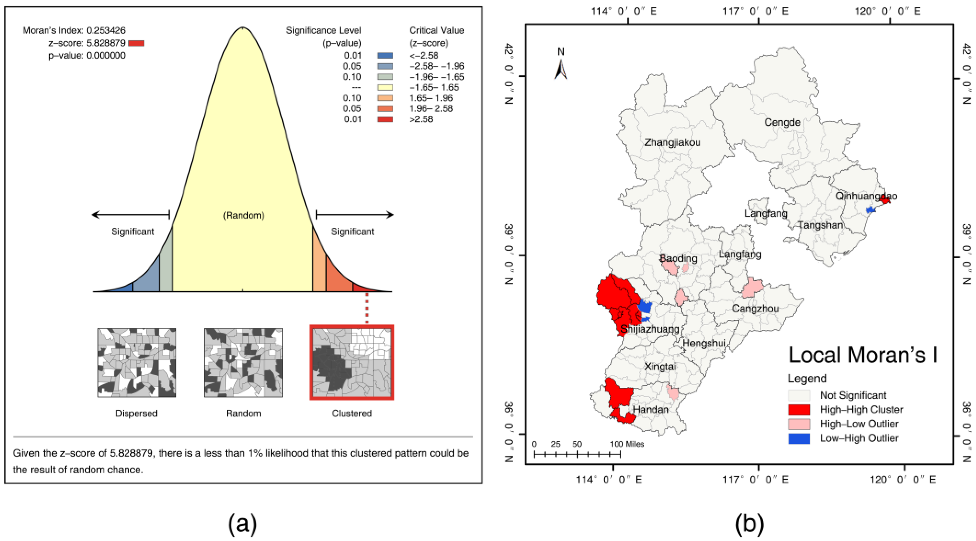
Subsequently, we performed a spatial autocorrelation analysis of the red industrial heritage distribution in Hebei Province using Global Moran’s I and Anselin Local Moran’s I in ArcGIS. Figure 4a presents the results of the Global Moran’s I calculation. Moran’s I value of 0.253426 suggests a significant deviation from random distribution, indicating a distinct clustering pattern of heritage sites. The z-score of 5.828879 suggests that the observed spatial autocorrelation significantly exceeds the standard error range of random distribution, further supporting the clustering of heritage sites. The p-value, well below 0.05, confirms the high significance of the spatial autocorrelation, almost ruling out the possibility of a completely random distribution. Therefore, it can be confirmed that the spatial distribution of red industrial heritage in Hebei Province exhibits a significant clustering pattern.
Figure 4b presents the LISA cluster map, which shows three types of local spatial clustering: high–high clusters in the western and eastern coastal areas, scattered high–low outliers in the central and southern parts, and low–high outliers primarily in the central and western regions. This clustering phenomenon is closely related to the influence of historical events and policies, especially during the formation of red industrial heritage, where multiple factors such as politics, economics, war, and geographical conditions contributed to the high concentration of these heritage sites in specific regions.
(2)
Spatial Distribution Characteristics in Different Periods
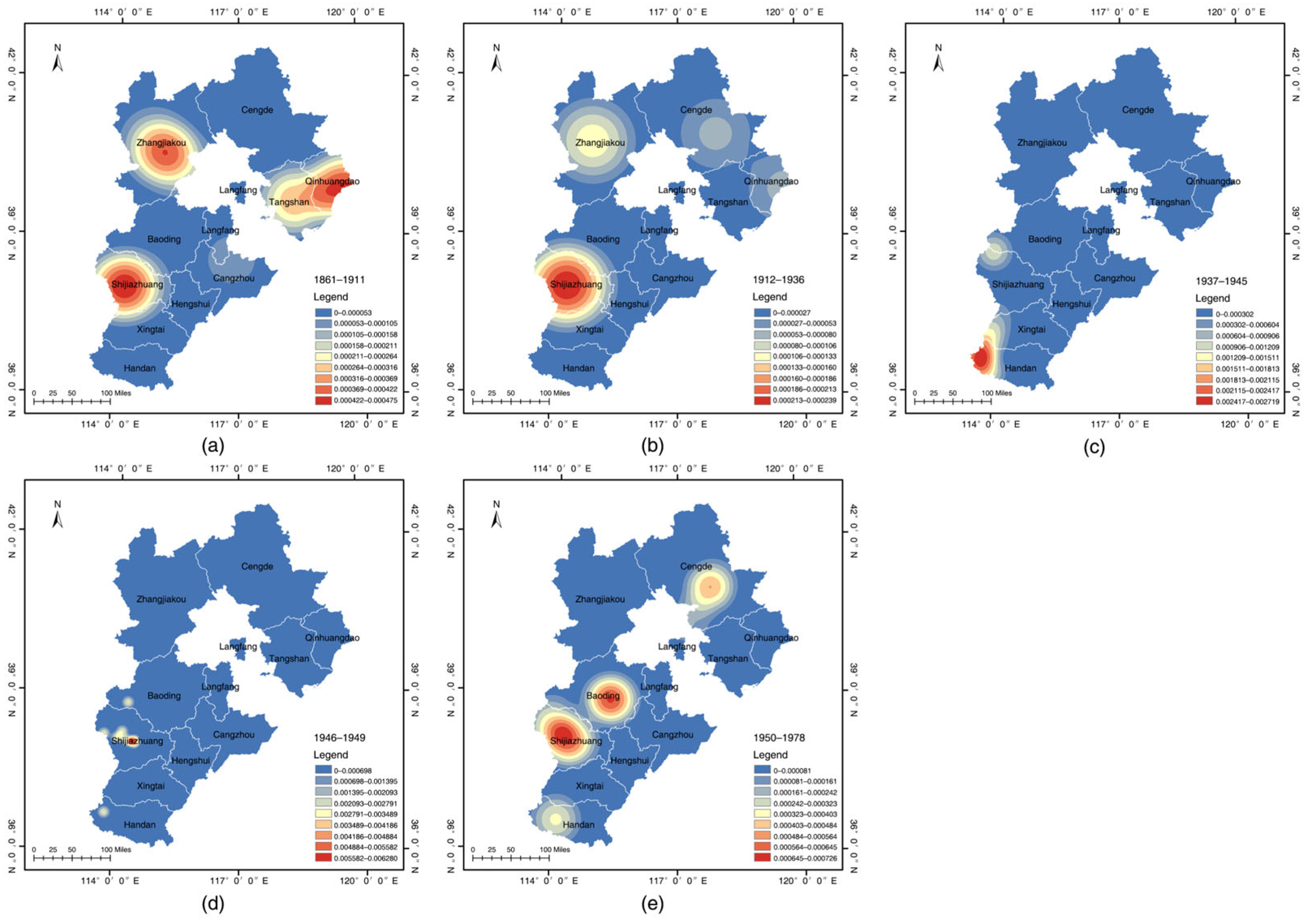
Figure 5a–e illustrate the spatial distribution of red industrial heritage in Hebei Province during various historical periods, effectively depicting the development process of this heritage in the province. Between 1861 and 1911, 22 new red industrial heritage sites were constructed in Hebei Province (Figure 5a). Among them, four were located in Tangshan, five in Qinhuangdao, six in Zhangjiakou, six in Shijiazhuang, and one in Cangzhou. Driven by the Westernization Movement, the establishment of new industrial enterprises and the fuel supply needs of military industries such as the Beiyang Navy and Tianjin Arsenal led to an unprecedented demand for coal. This period marked the creation of the first modern industrial heritage in Hebei, principally concentrated on coal mining. These factories not only introduced Western technology and equipment but also nurtured the initial industrial worker groups in Hebei, laying the groundwork for the emergence of red industrial heritage. To transport the coal, new ports, like West Port of Qinhuangdao, and railways, including the Tangxu Railway, Zhengtai Railway, and Jing-Zhang Railway, were constructed, leading to the formation of industrial heritage clusters along these railway lines. The spatial layout profoundly reflects the strategic orientation of the Westernization Movement, which aimed to “promote industry through mining, facilitate trade through railways, and develop mining through ports.”
Between 1912 and 1936, eight new red industrial heritage sites were established in Hebei Province (Figure 5b). Among these, four were located in Shijiazhuang, two in Zhangjiakou, one in Qinhuangdao, and one in Chengde. During this period, political upheavals and warlord conflicts had a certain impact on industrial development. At the same time, with the founding of the Republic of China, national capital began to rise, and Shijiazhuang, as an essential cotton-producing region in North China, accelerated the concentration of the textile industry. In response to the brutal exploitation of workers by colonial capital and infringements on national sovereignty, the working class gradually awakened. Under the leadership of the Communist Party, strikes were organized, trade unions were established, and the nationwide labor movement was continuously mobilized in resistance [43]. In 1935, China regained control of the Zhengtai Railway, marking a significant victory in China’s modern anti-colonial struggle. Industrial heritage sites evolved from mere places of production into strategic points for the workers’ movement.
Between 1937 and 1945, 26 new red industrial heritage sites were established in Hebei Province (Figure 5c). Among these, 15 were located in Handan, 4 in Xingtai, 3 in Shijiazhuang, 2 in Baoding, 1 in Chengde, and 1 in Zhangjiakou. As the War of Resistance Against Japanese Aggression intensified, the 115th and 129th Divisions in the Jin-Ji-Lu-Yu and Jin-Cha-Ji border areas established wartime industrial systems along the eastern foothills of the Taihang Mountains, forming the “Handan-Xingtai” Red Military–Industrial Belt. Due to the strict control of urban industrial facilities in both the Kuomintang-ruled and Japanese-occupied areas, villages became the only viable production bases behind enemy lines. These red factories, due to the need for secrecy, mobility, and mass support, were often hidden in villages, with most of the main buildings being requisitioned from private homes and temples rather than newly constructed. Local villagers actively assisted in the production and transportation of military products, and this collaboration between the military and civilians not only ensured the production of weapons but also reflected the Communist Party and the army’s wartime strategy. Red factories, such as the Huatuo Village munitions factory, continued to operate with the support of local villagers until the War of Resistance Against Japanese Aggression ended, becoming a microcosm of the resistance efforts behind enemy lines. Among the 26 sites, 92% are located in village areas along the Taihang Mountain range, at altitudes ranging from 280 to 1200 m. This dispersed distribution pattern reflects the guerrilla strategy of the Eighth Route Army and forms a rare wartime industrial geographical system in the world.
Between 1946 and 1949, eight new red industrial heritage sites were established in Hebei Province (Figure 5d). Among them, six were located in Shijiazhuang, one in Baoding, and one in Handan. The spatial distribution of red industrial heritage during the Liberation War exhibits a pattern of multiple points clustered around the revolutionary core area of Xibaipo, often situated in hidden mountainous regions. The Taihang Mountains, continuing from the core area of the War of Resistance Against Japanese Aggression, leveraged their hidden terrain and mass support to form a “command-production” system centered around Xibaipo. This area was home to military–industrial facilities, including munitions factories, printing factories, and radio stations.
Between 1950 and 1978, 16 new red industrial heritage sites were established in Hebei Province (Figure 5e). Among these, six were located in Shijiazhuang, four in Baoding, four in Chengde, and two in Handan. The First Five-Year Plan and the Third Front Construction primarily influenced the distribution of red industrial heritage during this period. Soviet-aided industrial projects during the First Five-Year Plan were mainly located in Shijiazhuang, Baoding, and Chengde, with these inland cities becoming key areas for industrial construction. As the provincial capital, Shijiazhuang concentrated multiple key projects, while Baoding and Handan, relying on their existing industrial foundation, became essential nodes. Chengde, due to its rich iron ore resources, was selected as a steel production base. During this period, red industrial heritage shifted from being distributed along mountain ranges with a focus on concealment during the war to a more centralized, urban-centered distribution, effectively utilizing existing transportation and infrastructure. The Third Front Construction was a pivotal period in the vigorous development and expansion of Hebei’s defense and technological industries. During this time, the new industrial layout in Hebei adhered to the principles of “proximity to mountains, decentralization, and concealment” [44], with major facilities situated in the deep mountain areas of the Yanshan and Taihang mountain ranges. This distribution maximized the use of natural mountain barriers, ensuring the survival capacity of wartime industrial systems.

3.1.3. Evolution of Centers and Spatial Shifts of Red Industrial Gravity

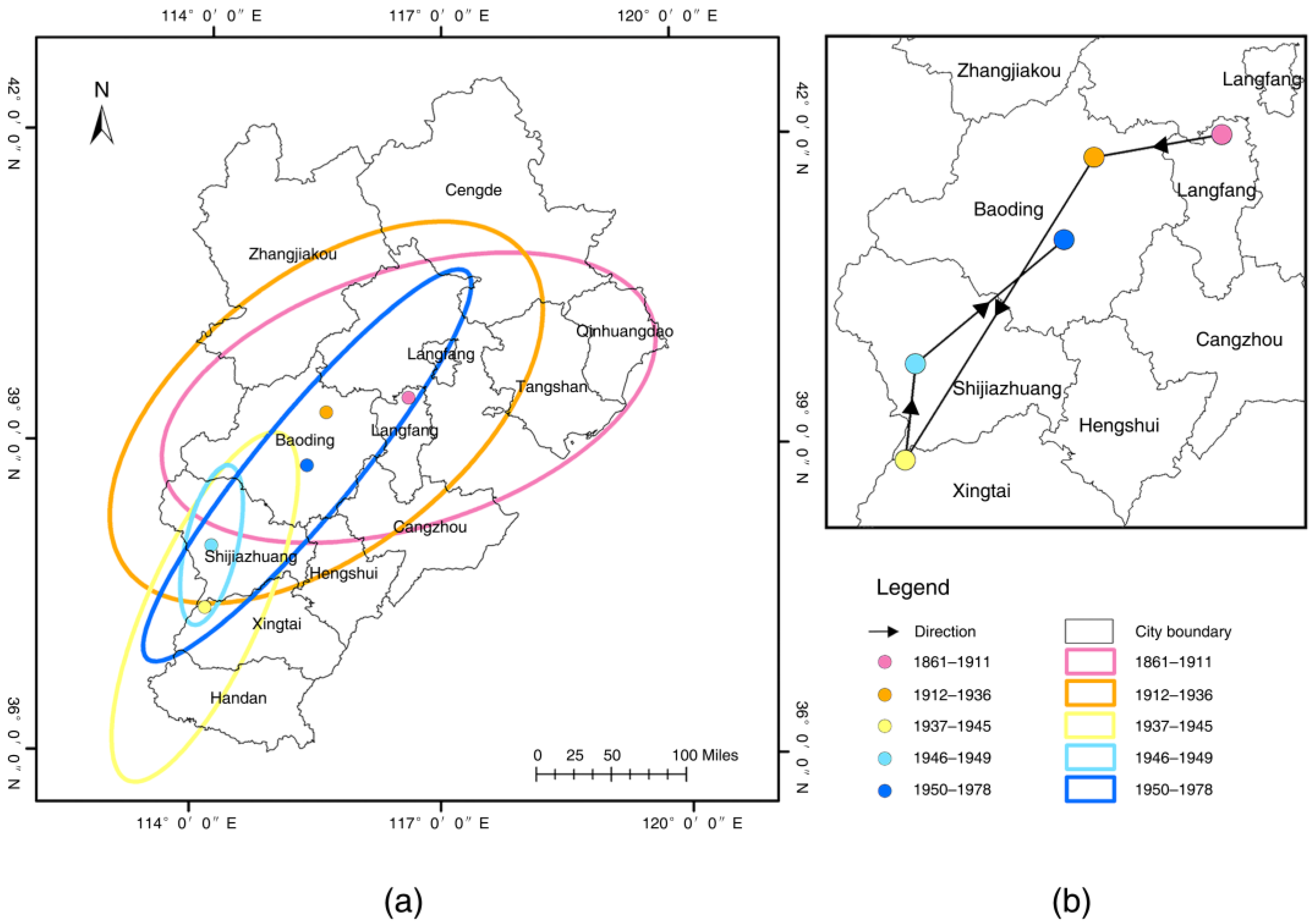
The spatial evolution characteristics of red industrial heritage in Hebei Province can be quantitatively analyzed by computing the standard deviational ellipse and mean center for each stage (Figure 6). A comparison of standard deviational ellipses across five periods reveals that the ellipses for 1861–1911 and 1912–1936 exhibit relatively larger areas and lower oblateness (Figure 6a), indicating that the distribution of red industrial heritage was more dispersed with weak directional characteristics. In contrast, during 1937–1945, 1945–1949, and 1949–1978, the ellipses were smaller with higher oblateness, indicating a more concentrated distribution with stronger directional characteristics. Figure 6b shows the locations and migration trends of the mean centers for the five periods. It can be observed that between 1861 and 1945, the mean center moved gradually from the central area of Langfang, near Beijing and Tianjin, to the southwestern part of the Taihang Mountains. Between 1945 and 1949, the mean center shifted slightly north, and by 1949–1978, it had moved out of the Taihang Mountains and into the central part of Baoding.
The movement of the mean center is closely related to the historical context of each period. Between 1861 and 1911, industrial sites established during the Westernization Movement were mainly located along railway lines and near ports, with the Tangshan–Qinhuangdao coastal industrial belt having the highest concentration of heritage sites. These sites formed a triangular distribution in the northern, eastern, and southern parts of Hebei Province, with the mean center located in the central area of Langfang. From 1912 to 1936, with the completion of the Pinghan and Zhengtai railways, Shijiazhuang became a significant transportation hub and a key area for labor movements, boasting the most significant number of heritage sites. The mean center shifted slightly to the west. Most wartime industries during the War of Resistance Against Japanese Aggression (1937–1945) were concentrated along the eastern foothills of the Taihang Mountains, primarily in Shexian County, Handan. The mean center underwent its first significant shift, moving from the geographic center of Hebei Province to the southwestern border. In the period of the Liberation War (1946–1949), the industrial system remained in a wartime state [45], with most heritage sites still concentrated in the Taihang Mountains. The mean center shifted slightly north. Between 1950 and 1978, covering both the First Five-Year Plan and the Third Front Construction, two periods with significantly different strategic objectives, the latitude of heritage site distribution spanned the most extensive range, with the strongest directional characteristics. The mean center shifted from the southwestern mountainous region to the central plain, marking the second significant movement.

3.2. Typological Spatial Distribution Characteristics

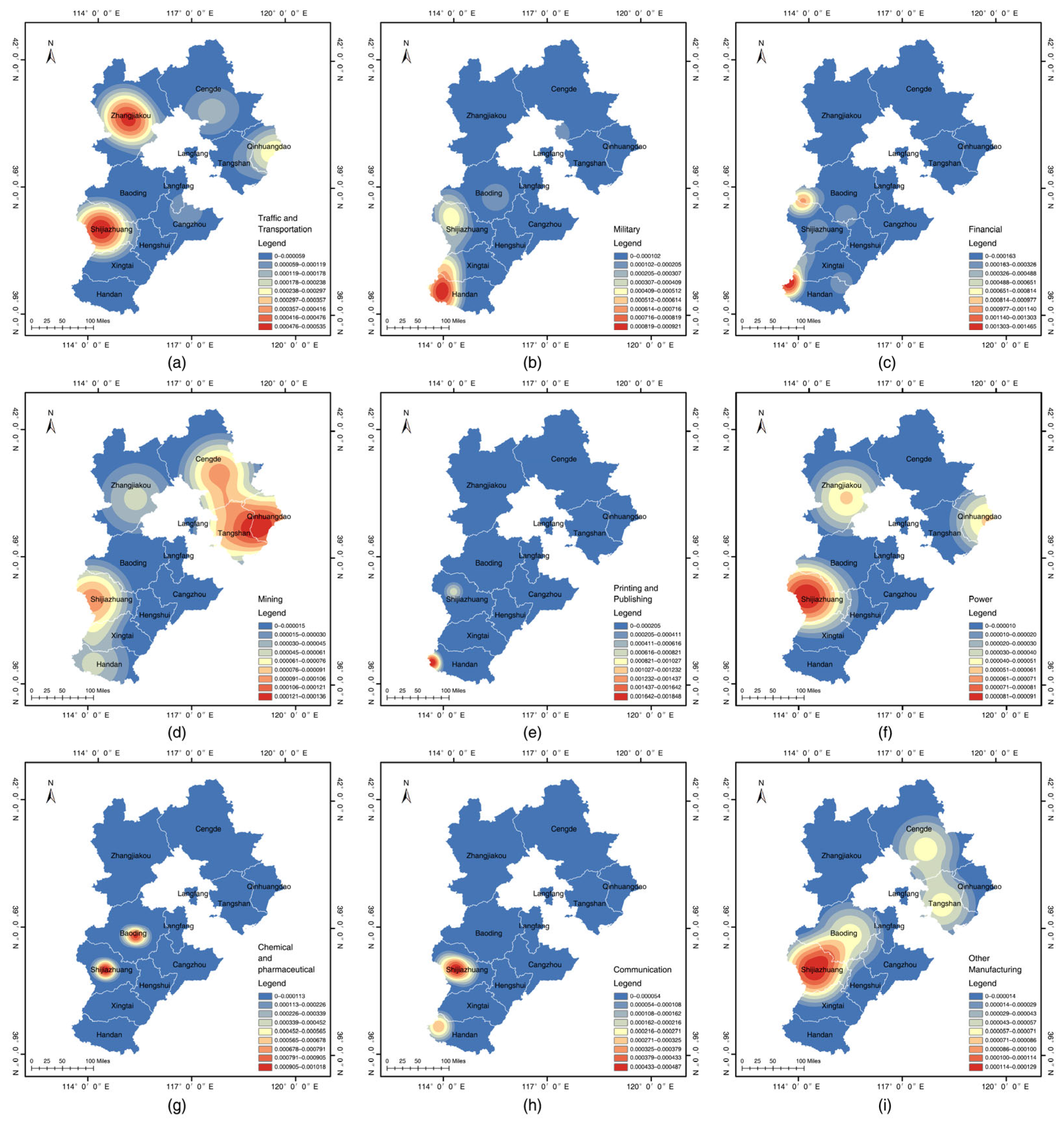
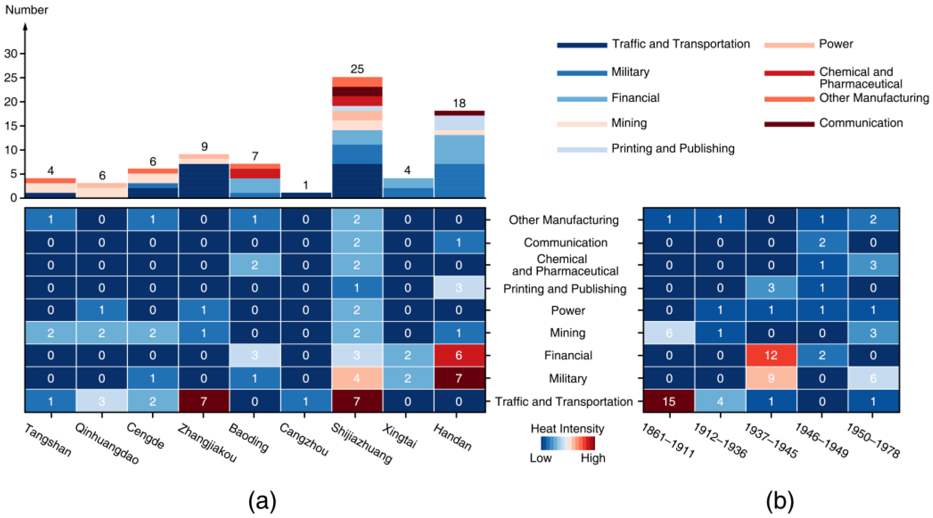
Based on the initial standards published in 1984, “National Economic Industry Classification and Codes” (GB 4754-84) [46], the current standard “National Economic Industry Classification” (GB/T 4754-2017) [47], and existing literature [48,49], we classify the red industrial heritage of Hebei Province into nine types. By combining the kernel density analysis of each type of red industrial heritage in Hebei (Figure 7), the location-type distribution table (Figure 8a), and the period-type distribution table (Figure 8b), it is evident that:
  • Traffic and transportation heritage accounts for 26.25%, primarily concentrated in Zhangjiakou and Shijiazhuang (Figure 7a). During the period from 1861 to 1911, this type of heritage saw the most new additions, corresponding to the construction of essential transportation lines, such as the Tangxu Railway, Zhengtai Railway, Pinghan Railway, and Jingzhang Railway. These railways promoted the development of railway hub cities, such as Shijiazhuang.
  • Military industrial heritage accounts for 18.75%, and is concentrated in the revolutionary base areas in the interior of the Taihang Mountains (Figure 7b). This type of heritage saw the highest number of additions during the War of Resistance Against Japanese Aggression, the First Five-Year Plan, and the Third Front Construction, providing crucial rear-area support for victory.
  • Financial heritage accounts for 17.5%, with a distribution pattern similar to that of military industrial heritage (Figure 7c), and saw the most additions during the War of Resistance Against Japanese Aggression. During the war, banks were established in the Jin-Ji-Lu-Yu and Jin-Cha-Ji border areas, and counterfeit currency was eliminated while border currency was issued [50]. This helped break the economic blockade imposed by the enemy and established an independent financial system, providing strong support for the survival and development of the war in the areas behind the enemy lines [51].
  • Mining heritage accounts for 12.5%, primarily located in areas rich in mineral resources, such as Chengde, Tangshan, Shijiazhuang, and Handan (Figure 7d). This type of heritage saw significant additions during the periods of 1861–1911 and 1950–1978.
  • Printing and publishing heritage accounts for 5%, with its scope of activities (such as printing currency) closely related to financial heritage. The appearance period and distribution range of this type of heritage are also similar to those of financial heritage (Figure 7e), and both were key measures of the Communist Party’s political, economic, and cultural struggle in the base areas behind the enemy lines.
  • Power industry’s heritage accounts for 5% and is distributed in industrial cities such as Shijiazhuang, Qinhuangdao, and Zhangjiakou (Figure 7f). It played a foundational role for other industries and saw additions during all four periods from 1912 to 1978.
  • Chemical and pharmaceutical heritage accounts for 5%, with distribution primarily in Shijiazhuang and Baoding (Figure 7g). The majority of new additions occurred during the First Five-Year Plan, which promoted the growth of China’s light industry and contributed to improvements in people’s livelihoods.
  • Communication heritage accounts for 3.75%, with distribution in Shijiazhuang and Handan (Figure 7h). The number of additions was concentrated during the Liberation War, where the red radio waves supported the three major campaigns of the war.
  • Heritage from other manufacturing industries, such as textiles, food, metallurgy, papermaking, and building materials, is relatively small in number but is distributed across several periods (Figure 7i), contributing to the diverse industrial heritage system of the red industry in Hebei Province.

3.3. Influencing Factors Analysis

The distribution of red industrial heritage is shaped by multiple factors. This study, based on existing theoretical frameworks in political geography, industrial location theory, and military geography, comprehensively considers both natural and human factors. It selects historical policy, natural resources, transportation, and topography as the main analytical dimensions, aiming to explore the multiple mechanisms influencing the spatial distribution of red industrial heritage in Hebei Province. Below is a detailed explanation of the theoretical sources for each indicator:
The theory of state policy and spatial configuration in political geography emphasizes that government policy direction and strategic layout significantly impact the industrialization process (and its heritage distribution) [52,53]. As a special form of industrial heritage that carries the memory of social changes in a particular historical period, the formation and development of red industrial heritage are influenced by historical and policy factors. Since these factors are difficult to quantify, this study employs qualitative analysis to explore their role in the formation of red industrial heritage.
According to industrial location theory [54], industrial activities tend to concentrate in areas with abundant resources and convenient transportation. Good transportation infrastructure and easily accessible raw materials reduce transportation costs, facilitate the movement of goods, and promote industrial clustering and development. Hebei Province is rich in coal, iron, petroleum, and other natural resources, which not only provided a solid material foundation for industrial construction but also became a focal point of competition between opposing forces during wartime. At the same time, resource development during the war laid the foundation for Hebei’s industrial growth.
Topographic factors have historically influenced the layout of red industrial heritage in Hebei, especially during wartime. Military geography theory asserts that the importance of topography in warfare cannot be ignored [55]. Areas with complex terrain, such as mountains and hills, were often selected for the construction of military–industrial facilities due to their natural defensive advantages. Therefore, topography is a crucial factor in understanding the spatial distribution patterns of red industrial heritage in Hebei Province.

3.3.1. Historical and Policy Factors

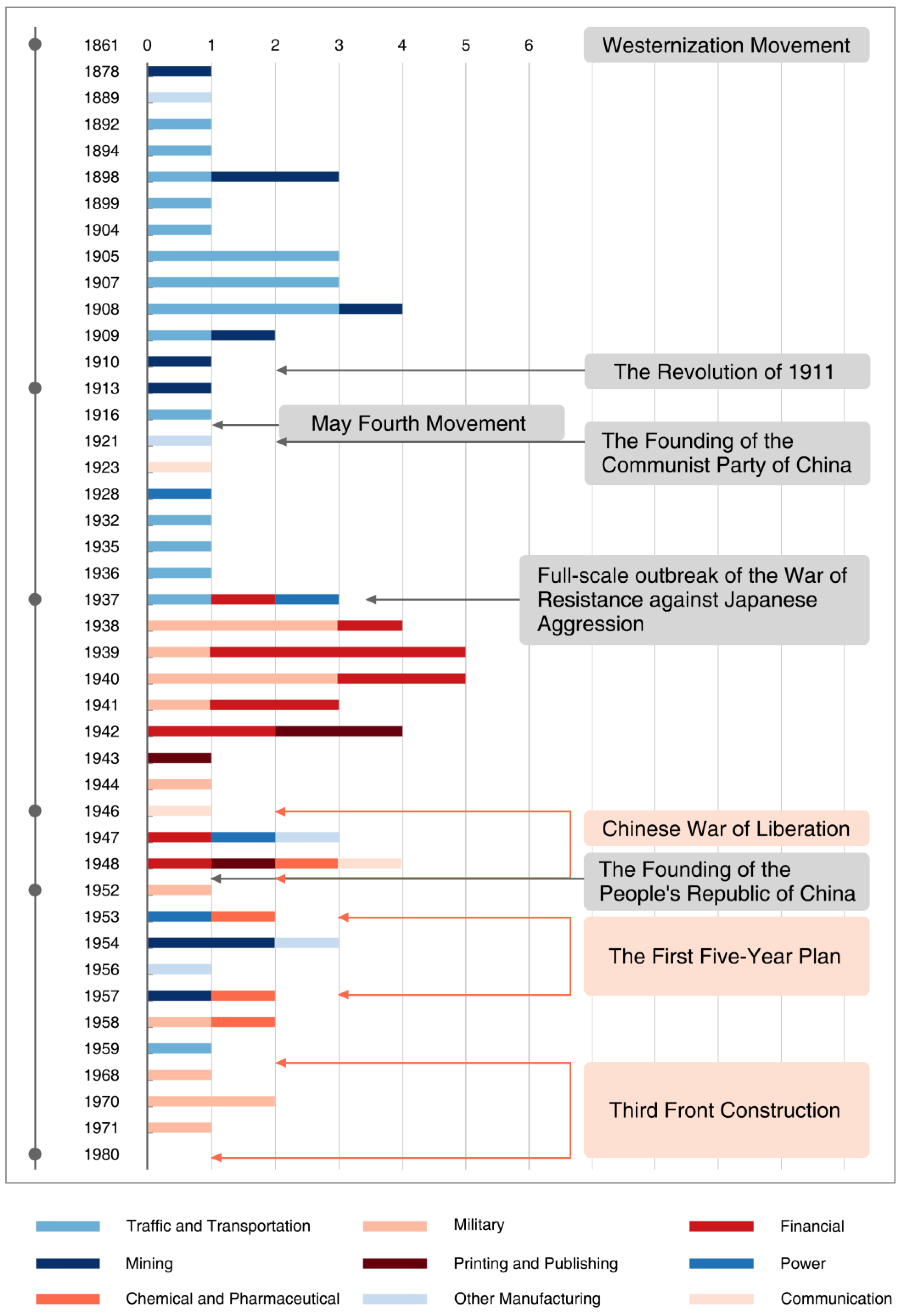
The formation and development of red industrial heritage in Hebei Province have been strongly shaped by historical and policy factors [56,57]. Figure 9 shows the establishment of different types of red industries in Hebei from 1861 to 1978. The changes in the number of each type of red industry reflect the development status of red industries in Hebei during different historical periods, as well as the relative significance of each type of industry. The vertical axis of the graph represents the years, with key historical events and periods marked, while the horizontal axis represents the number of newly established factories each year. The graph uses different colors to represent distinct types of red industries.
In 1861, the Westernization Movement began [58], aiming to address the fuel shortages in military industries and resist the importation of foreign coal. Tang Tingshu, appointed by Li Hongzhang, the Governor of Zhili, initiated the establishment of the large-scale modern coal mining enterprise, the Kaiping Mining Bureau. At the same time, the Tangxu Railway was constructed to transport coal, and China’s first steam locomotive was produced, inadvertently accelerating China’s modern transportation revolution. The completion of the Tangxu Railway also fueled the rapid development of the Kaiping coal mine, transforming a small village into the birthplace of modern industry in northern China. This development significantly contributed to the prosperity of Tangshan, a central industrial hub in northern China, and had a direct impact on the industrial landscape of modern China.
The Pinghan Railway was completed in 1906, the ZhengTai Railway in 1907, and the Jingzhang Railway in 1909, which accelerated the concentration of industries along their routes. Shijiazhuang became the junction of the Pinghan and ZhengTai Railways, and soon thereafter, transportation, services, and industrial enterprises rapidly developed, driving Shijiazhuang’s transformation from a rural area to an industrial city.
The Xinhai Revolution of 1911 overthrew the Qing Dynasty, marking the rise of national capitalism. The May Fourth Movement of 1919 promoted the integration of Marxism–Leninism with the Chinese workers’ movement, creating the conditions for the establishment of the Communist Party of China in 1921 and subsequent workers’ strikes. From 1921 to 1938, under the leadership of the Communist Party of China, workers from Kailuan Mining and the railway sector frequently engaged in labor movements, making factories and railways the focal points of these efforts. In 1922, the first CPC organization in Zhangjiakou was established along the Jingzhang Railway. The same year, it led railway workers in a successful struggle against imperialist powers and the Beiyang warlord government’s attempt to sell off railway rights. After the full outbreak of the War of Resistance against Japanese aggression in 1937, the 115th and 129th Divisions of the Eighth Route Army implemented the “village armaments factory” policy in the base areas behind the enemy lines, combining it with guerrilla tactics. In the heart of the Taihang Mountains, they established a wartime industrial system centered on the repair and production of light weapons, which was decentralized, concealed, and easily transferable. From 1946 to 1949, during the Liberation War, the Communist Party adopted the “protect industry and commerce” policy to stabilize the economy of the newly liberated areas, gain the support of the national bourgeoisie, and provide material foundations for the prolonged war. The liberated areas took over the mining areas and factories left behind by the Japanese and the puppet regime, renovated the equipment, built new pharmaceutical factories, and converted civilian factories into military production facilities, gradually restoring industrial output to support the frontlines.
After the founding of the People’s Republic of China in 1949, the “First Five-Year Plan” (1953) marked the beginning of systematic industrial reconstruction in Hebei. During the First Five-Year Plan, of the 156 key projects, heavy industries such as military, metallurgy, and energy were prioritized in Hebei, while civilian industries, including papermaking and pharmaceuticals, were also developed in parallel, forming an industrial cluster centered around Shijiazhuang. The distribution of these projects took into account national defense security, regional balanced development, and resource distribution, with a focus on areas with a strong foundation for development, such as Baoding and Shijiazhuang, which laid a solid foundation for Hebei’s industrial base and national defense capabilities. In 1960, as Sino–Soviet relations deteriorated and international tensions escalated, China initiated the “Third Front Construction” in 1964 to counter potential war threats and ensure national economic security [59]. Hebei Province conducted large-scale military industrial relocation activities, moving military industrial bases from surrounding coastal cities to inland mountainous areas [60]. Following the Third Front enterprise site selection principle of “proximity to mountains, decentralization, and concealment” [61], Hebei saw the development of “small Third Front” projects in Baoding, Xingtai, and Handan in the Yanshan and Taihang mountain ranges, while Zhangjiakou and Chengde served as strategic rear bases for Beijing and Tianjin. This formed a comprehensive military-industrial system spanning five sectors—ordnance, aviation, electronics, shipbuilding, and nuclear industries—integrating strategic rear areas from the Taihang Mountains in the south to the Yan Mountains in the north.

3.3.2. Natural Resource Factors

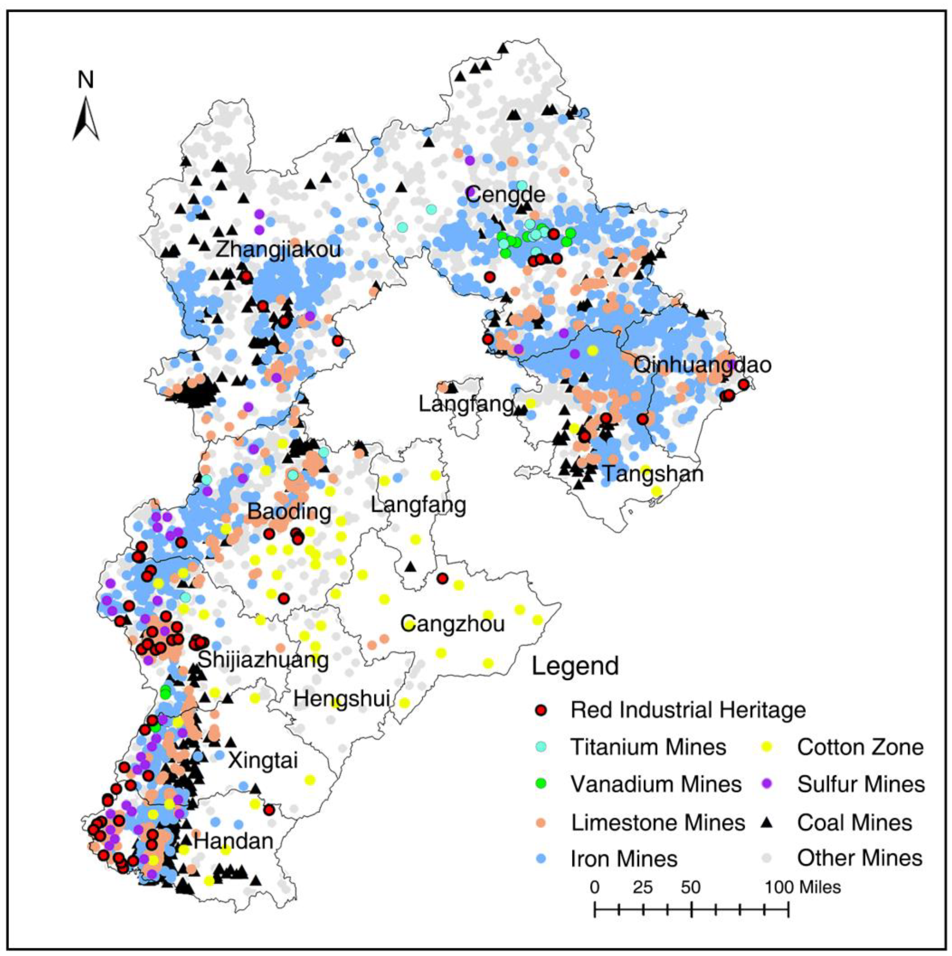
The distribution and development of red industrial heritage in Hebei Province is influenced by the region’s natural resources. Figure 10 shows the geographic distribution of major mineral resources in Hebei Province. Hebei has a complex geological structure with favorable mineralization conditions, making it rich in mineral resources [62]. Key resources include energy minerals such as coal, oil, and natural gas; metallic minerals like iron ore, titanium ore, and vanadium ore; and non-metallic minerals, including limestone, clay, and bauxite. These resources have provided raw materials and energy for local metal smelting, military industries, and chemical industries.
Hebei Province is rich in coal reserves, ranking 12th in China, with the primary deposits located in Tangshan, Handan, Xingtai, Zhangjiakou, and other areas. The abundant coal resources directly promoted the development of coal mining, processing, and transportation industries in these regions, while also driving the growth of the local steel smelting and cement industries as an energy source. The province’s iron ore is mainly distributed in the northern Yanshan Mountains and the western Taihang Mountains [63]. The overall structure of the steel industry is closely aligned with the geographical distribution of iron ore resources. In particular, the Chengde area is rich in vanadium-titanium magnetite [64], accounting for 40% of the country’s proven reserves, which provided the resource base for the establishment of metallurgical industries, such as the Rehe Iron Mine during the First Five-Year Plan. Additionally, Hebei Province’s favorable climate and abundant sunlight make it a key area for cotton production in North China. The main cotton-growing regions are concentrated in the central and southern Hebei Plain, with Shijiazhuang, Xingtai, Handan, and Baoding as the core areas. This region has a long history of cotton cultivation and processing, providing strong support for the relocation of numerous military uniform factories during the War of Resistance Against Japanese Aggression. The Taihang Mountains in the central and southern parts of Hebei are rich in coal, iron, and sulfur resources, providing unique natural conditions for the development of military industries in the Jin-Ji-Lu-Yu border area during the War of Resistance Against Japanese Aggression.
In summary, Hebei’s abundant natural resources, particularly coal, iron ore, and high-quality cotton, provided a solid material foundation for the formation and development of red industrial heritage. These resources not only stimulated the rise of local industries but also contributed significantly to the nation’s industrial development and revolutionary cause, profoundly influencing the distribution and evolution of red industrial heritage.

3.3.3. Transportation Factors

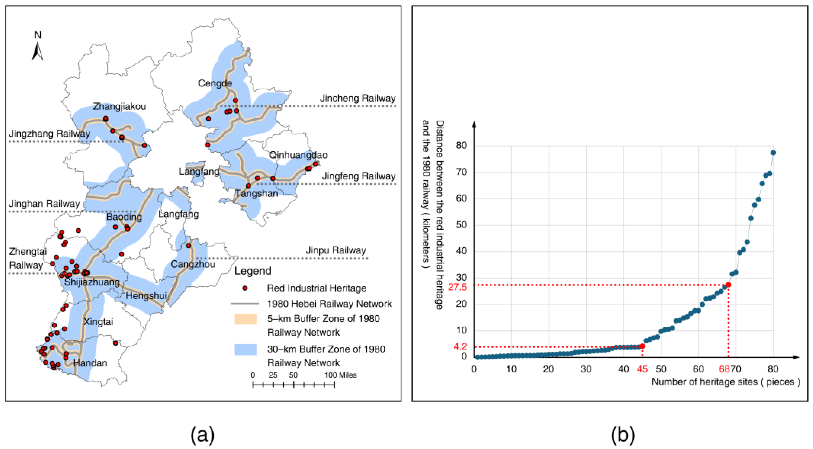
The transportation factors are closely related to the distribution and development of red industrial heritage in Hebei Province. The railway network, akin to the industrial lifeblood, runs through the heritage sites and accelerated the transformation of Hebei’s modern industry from non-existence to establishment, profoundly influencing the course of revolutionary wars in North China. Using the Near analysis, the vertical distances from heritage sites to the 1980 railway network were statistically analyzed and processed in Excel, resulting in a scatter plot with a trendline showing the relationship between the heritage sites and the railway distance (Figure 11b). It can be observed that the slope of the curve changes significantly at 4.2 km and 27.5 km. Within 4.2 km, the curve is relatively flat, containing 56.25% of the heritage sites, while beyond 27.5 km, the curve becomes steeper, containing 15% of the heritage sites. The calculated average distance between the heritage sites and the railway is 13.6 km. Among the 80 red industrial heritage sites, 45 sites (56.25%) are densely distributed within 15 km of the railway, while only 12 (15%) are located more than 30 km away (Figure 11a). This distribution density demonstrates a positive correlation between railway transportation and the layout of red industrial heritage.
Numerous labor movements and major battles in Hebei’s red history have centered around the railways [65]. In 1922, the Jingfeng Railway workers’ strike and the 1931 Zhengtai and Pinghan Railway workers’ strike, both led by the Chinese Communist Party, secured fundamental labor rights for industrial workers. During the War of Resistance Against Japanese Aggression, in 1940, the Hundred Regiments Offensive saw the Eighth Route Army attack and destroy key railway lines, including the Zhengtai, Pinghan, and Jinpu railways, cutting off the core supply line for Japanese forces in North China. During the Liberation War in 1947, the core battles of the Zhengtai Campaign were fought along the Zhengtai Railway, liberating seven cities, including Jingxing, Zhengding, and Yangquan, which laid the foundation for the eventual liberation of Shijiazhuang six months later. Following the establishment of the People’s Republic of China in 1949, the transportation networks damaged by the war were rapidly restored across Hebei, ensuring the flow of industrial construction materials and products, which vigorously promoted industrial recovery and economic revival.

3.3.4. Topographic Factors

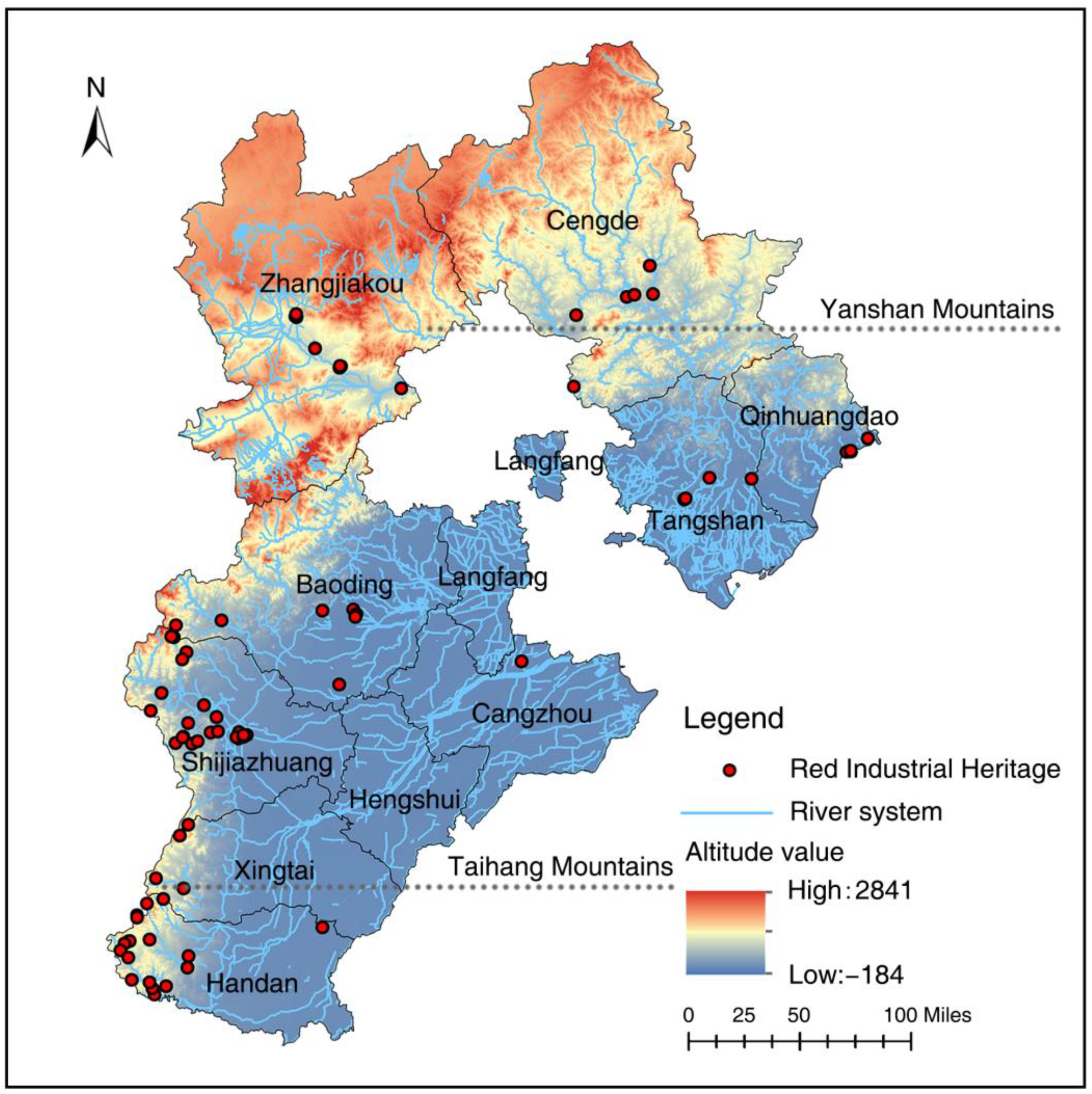
Topographical conditions also play a crucial role in shaping the distribution and development of red industrial heritage in Hebei Province. Hebei has a complex and diverse terrain, being the only province in China that features plateaus, mountains, plains, hills, basins, lakes, and coastlines. The province has a high northwest and a low southeast, with three main topographic units from northwest to southeast: the Bashang Plateau, the Yanshan-Taihang Mountain region, and the Hebei Plain. The altitude descends concentrically in a stepwise pattern (Figure 12). This notable variation in topography significantly influences the placement and arrangement of industrial heritage, especially during wartime.
The rugged terrain of the Taihang and Yanshan mountain ranges provided natural barriers for the concealment and security of red industrial heritage. During the War of Resistance Against Japanese Aggression, the mountainous regions with strong concealment became ideal locations for military industrial facilities. Many of the Eighth Route Army’s weapon factories were situated in remote mountain villages, where the complex terrain and the cover provided by residents effectively shielded them from enemy reconnaissance and attacks, ensuring a stable supply of weapons and ammunition. This had significant military and strategic value. During the Third Front Construction, the topographical advantages of the mountains were once again fully utilized. In response to the complex international situation and strategic defense needs, crucial national defense industrial projects were located in the concealed areas of the Taihang and Yanshan mountain ranges, forming a “relying on mountains, decentralizing, and concealing” pattern of national defense industrial layout.

4. Discussion

This section interprets the GIS analysis results, integrates them with historical background and policy context, and compares them with existing industrial heritage research. Based on the spatial distribution and influencing factors of red industrial heritage in Hebei Province, this study proposes a gradient-based protection strategy aligned with sustainable development goals and discusses research boundaries and future directions.

4.1. Spatiotemporal Distribution Patterns

Kernel density analysis shows a significant concentration of red industrial heritage in the central and southern parts of Hebei, with a distinct linear aggregation along the eastern foothills of the Taihang Mountains, where military–industrial heritage sites are most prevalent. Spatial autocorrelation analysis quantitatively confirms the clustering pattern of heritage sites. These areas were critical during the War of Resistance Against Japanese Aggression as base areas behind the enemy lines and strategic regions during the Third Front Construction, with their geographical seclusion and strategic importance making them ideal for military–industrial site placement. After the end of the Cold War, international tensions eased, and the urgency of wartime strategies diminished, leading to the relocation of many factories to urban areas due to high transportation costs in the remote mountainous regions, leaving behind a significant amount of red industrial heritage.
Standard deviational ellipse and mean center analysis indicate that during the late Qing Dynasty, industrial activities were concentrated along the Bohai coastline and railway lines. During the War of Resistance Against Japanese Aggression, industrial activities shifted to the Taihang Mountains for strategic reasons, and after 1949, the industrial center returned to urban areas. This temporal migration pattern, distinct from ordinary industrial heritage, reflects the role of circumstances and policies in influencing the formation and relocation of red industrial heritage.

4.2. Driving Mechanisms

Studies on industrial heritage globally and domestically show that industrial heritage tends to be concentrated in towns with well-developed infrastructure and high levels of social development [1,30,66], typically driven by economic transformation and technological progress. However, these studies primarily emphasize economic factors and technological contributions, whereas the red industrial heritage in Hebei highlights the influence of historical events and policy interventions.
The empirical results of this study show that the spatial distribution of red industrial heritage in Hebei is shaped by historical policies, natural resources, transportation, and topographic conditions. GIS analysis indicates that from the Westernization Movement to the Third Front Construction, the spatial distribution of red industrial heritage has evolved in response to changes in political and military demands, emphasizing the key role of historical policy in shaping the pattern of industrial heritage. This aligns with Brenner’s theory of state spatial restructuring, which highlights the government’s dominant role in coordinating industrial geography.
Natural resources and transportation conditions are crucial factors in the spatial distribution of industrial heritage in Hebei. The abundant mineral resources in Tangshan, Handan, and other regions laid a solid foundation for heavy industry development, while the well-developed transportation network, particularly the railway system, further facilitated industrial clustering. This supports the description in industrial location theory that industries tend to locate near raw material sources and transportation hubs. Topographic factors also influenced industrial site selection, but unlike the flatland concentration typical of regular industrial heritage, red industrial heritage focused more on the strategic defense function of terrain, leading to clustering in higher-altitude areas. The Taihang and Yanshan mountains provided natural defensive advantages during wartime, which aligns with military geography theory emphasizing the defensive value of terrain. Thus, the mechanisms governing the spatial distribution of red industrial heritage encompass not only universal industrial location principles—such as proximity to raw materials and access to well-developed transport infrastructure—but also distinctive military geographical imperatives prioritizing terrain defensibility over concentration on plains.

4.3. Protection and Revitalization Strategies

Current protection practices often simplify red industrial heritage as a mere appendage to revolutionary relics, neglecting the inherent value of its “red” and “industrial” elements. This study, through spatiotemporal analysis, demonstrates that the “red gene” is not merely an external label but the fundamental force shaping the spatial form and functional core of the heritage. Protection practices must go beyond traditional commercial transformation models and explore revitalization paths based on the authenticity of heritage and the transmission of the era’s spirit [67,68,69].
Red industrial heritage involves industrial construction during special historical periods such as the War of Resistance Against Japanese Aggression, Liberation War, and the Third Front Construction, with a large portion located in remote, mountainous areas far from urban centers. These areas have weaker tourist appeal and face difficulties in linking with surrounding scenic spots, complicating heritage protection and utilization. Furthermore, some heritage sites are scattered throughout villages. Initially serving as civilian residences or temples, they provided crucial support for revolutionary activities during wartime, becoming physical manifestations of the revolutionary spirit and collective will. After the war, they reverted to their original residential functions. Revitalizing these sites without impacting the local population’s daily life and the ecological environment is an urgent issue to address. Additionally, many red industrial heritage sites were built during wartime, using local folk craftsmanship and materials, which makes them structurally more fragile compared to ordinary industrial heritage sites with large, sturdy buildings. Timely identification and protection of these sites can effectively prevent further deterioration, thus enabling rescue preservation.
This study advocates for differentiated revitalization and protection strategies: For the village clusters, a minimal intervention approach combined with digital restoration should be used to create ecological museums, integrating local oral histories and displays of military–industrial techniques, while preserving the authenticity of the “civil–military symbiosis.” For urban clusters, the transformation mechanism of industrial heritage in coexistence with cities should be explored through the connection of public spaces, the cross-border fusion of scenes, and innovative financial models [70,71,72], to stimulate urban vitality and preserve collective memory [73]. For cross-regional heritage such as the “Handan–Xingtai Red Military Industrial Belt,” corridor-level protection plans should be established [74], linking heritage sites along corridors to prevent the fragmented utilization of core heritage [75].

4.4. Research Boundaries and Future Directions

This study integrates GIS spatial analysis with historical geography methods, combining spatial quantitative statistics with historical qualitative interpretations, enhancing the explanatory depth of GIS-based heritage research. The “pattern–process–mechanism” analytical framework constructed in this study is not only applicable to other revolutionary base areas in China but can also be extended to industrial heritage research in other socialist countries such as Vietnam and North Korea, supporting the development of a global “Socialist Industrial Heritage Geography.”
At the same time, this study has certain limitations: First, the analysis is primarily based on regional data sets, making it difficult to fully reflect the overall pattern of red industrial heritage across China or globally. Second, the analysis of driving mechanisms focuses on macro factors, with limited exploration of the agency of micro-level actors such as workers and technical experts. Future research will combine oral history and corporate archives to deepen the study and further refine the multidimensional analysis framework of driving mechanisms, providing theoretical support for developing relevant protection strategies. Moreover, by comparing the spatial distribution of industrial heritage across different provinces or countries with similar socialist historical backgrounds, the research scope can be expanded to gain a more comprehensive understanding of the global significance of this type of heritage and explore the impact of local differences on its revitalization paths.

5. Conclusions

This study focuses on 80 red industrial heritage sites in Hebei Province, utilizing a combination of Geographic Information System (GIS) spatial analysis and historical geography methods to systematically analyze their spatiotemporal distribution characteristics, evolutionary patterns, and driving mechanisms. The following conclusions were drawn in response to the core research questions:
Firstly, the red industrial heritage in Hebei Province exhibits a distinct regional concentration and uneven distribution. It is primarily concentrated in the central and southern parts of Hebei, forming a high-density zone centered around Handan and Shijiazhuang. At the same time, the northern and eastern regions are more dispersed. In terms of type, transportation, military industry, and finance are the dominant categories, with their distribution highly coupled with the railway network, mineral resources, and revolutionary bases. Over time, the distribution centers of the heritage sites shifted from the late Qing period’s coastal and railway lines to the strategic western region in the Taihang Mountain area during the War of Resistance against Japanese Aggression, and eventually returned to the plain cities after the founding of the People’s Republic of China. This migration path responds to significant historical events: the Westernization Movement fostered basic industries along railways and mineral distribution, the War of Resistance Against Japanese Aggression pushed red industry “up the mountains and into villages” towards concealed production, while the First Five-Year Plan and the Third Front Construction reshaped the industrial geography centered around cities, balancing military preparedness needs.
Secondly, the formation of the spatiotemporal pattern of heritage sites is shaped by multiple factors. Among these, historical policies play a dominant role, as key historical events directly impact the spatial distribution of heritage. Natural resources form the essential basis, with coal, iron ore, and cotton-producing regions laying the groundwork for the distribution of mining, metallurgy, and textile industries. The transportation network serves as the spatial framework—railways, such as the Pinghan and Zhengtai, not only drove the rise of transportation hubs like Shijiazhuang but also became central battlefields for labor movements and military campaigns. Geographical conditions played a key role during wartime: the complex terrain of the Taihang and Yanshan mountains provided natural barriers for armaments factories during the War of Resistance Against Japanese Aggression and Third Front enterprises, and the “relying on the mountains, dispersed, and concealed” distribution model became an adaptive choice to mitigate war risks.
Finally, this study deepens the understanding of the value dimensions and practical pathways for red industrial heritage. On a theoretical level, the Hebei case demonstrates that the essence of red industrial heritage lies in the organic integration of “revolutionary spirit transmission” and “industrial technology.” Its spatial layout served revolutionary mobilization, while technological breakthroughs highlighted the achievements of socialist industrialization. The fusion of “red” and “industrial” characteristics broadens the value dimensions in the international industrial heritage evaluation system and establishes a value recognition framework that includes the four dimensions of “history, technology, society, and politics.” On a practical level, in response to issues such as policy gaps, excessive commercialization, and the loss of authenticity in current preservation efforts, the study proposes a classification-based revitalization strategy. Only by updating value recognition, overcoming limitations in preservation systems, and innovating revitalization models can red industrial heritage break free from the constraints of specimen-based protection, truly becoming a sustainable vehicle for transmitting socialist industrial civilization and enhancing cultural identity, while offering a “Chinese solution” to global industrial heritage preservation that integrates political narrative and technological innovation.

Author Contributions

Conceptualization, X.C. and X.L.; Methodology, X.C.; Software, X.C.; Validation, X.C. and X.L.; Formal analysis, X.C.; Investigation, X.C.; Resources, X.C. and X.L.; Data curation, X.C.; Writing—original draft preparation, X.C.; Writing—review and editing, X.L.; Visualization, X.C.; Supervision, X.L. All authors have read and agreed to the published version of the manuscript.

Funding

This research was funded by Hebei Provincial Social Science Foundation Project: “Research on the Synergistic Effects and Models of Industrial Heritage and the Development of Old Industrial Cities under the Context of Urban Renewal”, grant number HB23YS004.

Institutional Review Board Statement

Not applicable.

Informed Consent Statement

Not applicable.

Data Availability Statement

The datasets used and analyzed during the current study are available from the corresponding author upon reasonable request.

Conflicts of Interest

The authors declare no conflicts of interest.

Abbreviations

The following abbreviations are used in this manuscript:
GISGeographic Information System
TICCIHThe International Committee for the Conservation of the Industrial Heritage
APIApplication Programming Interface
PLAPeople’s Liberation Army of China
CPCCommunist Party of China

References

  1. Yan, M.; Li, Q.; Zhang, J. Rethinking Industrial Heritage Tourism Resources in the EU: A spatial perspective. Land 2023, 12, 1510. [Google Scholar] [CrossRef]
  2. Avrami, E.; Macdonald, S.; Mason, R.; Myers, D. Values in Heritage Management: Emerging Approaches and Research Directions; The Getty Conservation Institute: Los Angeles, CA, USA, 2019. [Google Scholar]
  3. Labadi, S.; Logan, W. Approaches to urban heritage, development and sustainability. In Urban Heritage, Development and Sustainability; Routledge: Oxfordshire, UK, 2015; pp. 1–20. [Google Scholar]
  4. Xie, P.F. Industrial Heritage Tourism; Channel View Publications: North York, ON, Canada, 2015; Volume 43. [Google Scholar]
  5. Cheng, S.M.; Bowring, J. Rust, Dust, Smoke and Smell: Memoryscapes for Industrial Heritage. Herit. Soc. 2024, 17, 413–438. [Google Scholar] [CrossRef]
  6. The International Committee for the Conservation of the Industrial Heritage (TICCIH). The Nizhny Tagil Charter For The Industrial Heritage. 2003. Available online: https://ticcih.org/about/charter/ (accessed on 15 March 2025).
  7. Lu, N.; Min, L.; Wang, R. Reproducing the discourse on industrial heritage in China: Reflections on the evolution of values, policies and practices. Int. J. Herit. Stud. 2020, 26, 498–518. [Google Scholar] [CrossRef]
  8. Qian, Z. Heritage conservation as a territorialised urban strategy: Conservative reuse of socialist industrial heritage in China. Int. J. Herit. Stud. 2023, 29, 63–80. [Google Scholar] [CrossRef]
  9. Han, H. Outline of the Red Industrial Heritage: Based on the Perspective of the Communist Party of China Leading the National Modernization. Urban Dev. Stud. 2021, 28, 62–68. [Google Scholar]
  10. Ciprian, C.C. Communist heritage tourism and red tourism: Concepts, development and problems. Cinq Cont. 2011, 1, 29–39. [Google Scholar]
  11. Urban Planning Society of China. The Third Batch of China’s Industrial Heritage Protection List Released. Available online: https://www.planning.org.cn/news/view?id=14513 (accessed on 16 April 2025).
  12. Ministry of Industry and Information Technology of the People’s Republic of China. Notice of the Ministry of Industry and Information Technology of the State Administration of Cultural Heritage on the Announcement of the List of Typical Cases of Protecting and Utilizing Witnesses of the “Seal of the Republic” and Industrial Heritage. Available online: https://www.miit.gov.cn/jgsj/zfs/gzdt/art/2024/art_170582e464234feb96b9b83aff76c05e.html (accessed on 15 March 2025).
  13. Zhong, M. Research on Industrial Heritage Renewal Strategy Based on “Place Event” Theory—Taking Anyuan Coal Mine as an Example. Master’s Thesis, Jiangxi Normal University, Nanchang, China, 2021. [Google Scholar]
  14. Zhao, Y. Research on Spatial Optimization of Red Industrial Heritage Based on Spatial Syntax—Taking Daqing Hongqi Village Gandalei Building Complex as an Example. Master’s Thesis, University of South China, Hengyang, China, 2023. [Google Scholar]
  15. Zhong, Z. Research on Ecological Protection and Reuse of Industrial Heritage in the Central Soviet Area of Southern Jiangxi. Master’s Thesis, Jiangxi University of Science and Technology, Ganzhou, China, 2021. [Google Scholar]
  16. Li, Z. Research on the Effective Realization of the Ideological and Political Education Function of Red Industrial Heritage. Master’s Thesis, Guilin University of Electronic Technology, Guilin, China, 2024. [Google Scholar]
  17. Han, H. On the Mechanism and Path of the Red Industrial Heritage in the Role of the Dissemination of the Spiritual Genealogy of Chinese Communists. J. Cent. China Norm. Univ. (Humanit. Soc. Sci.) 2022, 61, 71–78. [Google Scholar] [CrossRef]
  18. Liu, J.; Duan, Y.; Wang, Y. Investigation and Characteristic Analysis of the Status Quo of Red Industrial Heritage in Jiangxi. Urban Archit. 2021, 18, 80–83+100. [Google Scholar] [CrossRef]
  19. Ma, X.; Zhang, Y.; Li, Y.; Li, Y.; Lin, F. Spatial–temporal distribution and evolution of the socialist built heritage in China, 1949–1978. Herit. Sci. 2023, 11, 214. [Google Scholar] [CrossRef]
  20. Wang, N. Research on the Evolution and Planning Response of “156 Projects” in Emerging Industrial Cities in Northwest China—Taking Lanzhou and Xi’an as Examples. Master’s Thesis, Lanzhou Jiaotong University, Lanzhou, China, 2022. [Google Scholar]
  21. Yan, M. The Research of Industrial Heritage Cluster in Tianjin as the Center of the Zhili Province. PhD. Thesis, Tianjin University, Tianjin, China, 2015. [Google Scholar]
  22. Bekus, N.; Cowcher, K. Socialism, Heritage and Internationalism after 1945. The Second World and Beyond. Int. J. Herit. Stud. 2020, 26, 1123–1131. [Google Scholar] [CrossRef]
  23. Kochetkova, E.; Petrova, A. Abandoned, but not forgotten heritage: Former industrial enterprises in cultural and urban Russian landscapes. Herit. Soc. 2022, 15, 277–298. [Google Scholar] [CrossRef]
  24. Petrović, T. Heritage of liminality: Remnants of the military in the Istrian city of Pula in the aftermath of Yugoslav socialism. In Colloquia Humanistica; Instytut Slawistyki Polskiej Akademii Nauk: Warsaw, Poland, 2021; pp. 1–21. [Google Scholar] [CrossRef]
  25. Venovcevs, A. Living with socialism: Toward an archaeology of a post-soviet industrial town. Extr. Ind. Soc. 2021, 8, 100835. [Google Scholar] [CrossRef]
  26. Wang, Y. The Industrial Heritage Survey and Value Evaluation of Hebei Province. Master’s Thesis, Hebei University of Engineering, Handan, China, 2018. [Google Scholar]
  27. Jiang, T. Modern Chinese History, 1st ed.; Tianjin People’s Publishing House: Tianjin, China, 2016. [Google Scholar]
  28. Liu, B.; Wu, C.; Xu, W.; Shen, Y.; Tang, F. Emerging trends in GIS application on cultural heritage conservation: A review. Herit. Sci. 2024, 12, 139. [Google Scholar] [CrossRef]
  29. Wang, H.; Chen, X.; Ge, J.; Yan, Z.; He, X.; Song, Y.; Zhou, Q. Research on the spatiotemporal distribution and cultural tourism strategy of modern educational architectural heritage in Nanjing. Sustainability 2023, 15, 14392. [Google Scholar] [CrossRef]
  30. Fan, X.; Sun, L. Geographic distribution characteristics and influencing factors for industrial heritage sites in Italy based on GIS. Sustainability 2024, 16, 2085. [Google Scholar] [CrossRef]
  31. Li, X. Determination of the temporal-spatial distribution patterns of ancient heritage sites in China and their influencing factors via GIS. Herit. Sci. 2024, 12, 143. [Google Scholar] [CrossRef]
  32. Yang, D.; Liu, X. A Framework for Mapping Urban Spatial Evolution: Quantitative Insights from Historical GIS and Space Syntax in Xi’an. Sustainability 2025, 17, 3113. [Google Scholar] [CrossRef]
  33. Liu, S.; Liu, Y.; Zhang, R.; Cao, Y.; Li, M.; Zikirya, B.; Zhou, C. Heterogeneity of Spatial Distribution and Factors Influencing Unattended Locker Points in Guangzhou, China: The Case of Hive Box. ISPRS Int. J. Geo-Inf. 2021, 10, 409. [Google Scholar] [CrossRef]
  34. Liu, W.; Xue, Y.; Shang, C. Spatial distribution analysis and driving factors of traditional villages in Henan province: A comprehensive approach via geospatial techniques and statistical models. Herit. Sci. 2023, 11, 185. [Google Scholar] [CrossRef]
  35. Anselin, L. Local indicators of spatial association—LISA. Geogr. Anal. 1995, 27, 93–115. [Google Scholar] [CrossRef]
  36. Zhang, J.; Zhuo, L.; Sun, H.; Wang, Y.; Wei, H.; Xu, S.; Aoki, N. Construction of the Chinese Route of Industrial Heritage Based on Spatial and Temporal Distribution Analysis. Buildings 2024, 14, 1065. [Google Scholar] [CrossRef]
  37. Chen, M.; Wang, J.; Sun, J.; Ye, F.; Zhang, H. Spatio-temporal distribution characteristics of intangible cultural heritage and tourism response in the Beijing-Hangzhou Grand Canal Basin in China. Sustainability 2023, 15, 10348. [Google Scholar] [CrossRef]
  38. Liu, Y.; Luo, T. Exploring the Temporal, Spatial and Characteristic Trends and Key Influencing Factors of Tianjin’s Industrial Heritage. Sustainability 2024, 16, 9267. [Google Scholar] [CrossRef]
  39. Zhu, C. The History of Modern Chinese Industry; Chongqing Publishing House: Chongqing, China, 1989. (In Chinese) [Google Scholar]
  40. Tan, K. History of Chinese Revolutionary Base Areas; Fujian People’s Publishing House: Fuzhou, China, 2007. (In Chinese) [Google Scholar]
  41. Wang, J. China’s Early Modern Industrial History Data; Science Press: Beijing, China, 1957. (In Chinese) [Google Scholar]
  42. Liu, S. On the Military-Industrial Development in Late Qing China. Mil. Hist. Res. 1991, 1, 96–111. (In Chinese) [Google Scholar]
  43. Editorial Committee of the Workers’ Movement History in ‘Sanjin’ Revolutionary Base Areas. A History of the Labor Movement in the Jin-Cha-Ji Revolutionary Base Area; China Workers’ Publishing House: Beijing, China, 1992. (In Chinese) [Google Scholar]
  44. Yin, Q. Between the mountains, the city, and the world: The microhistory of a ‘Small Third Front’ Chinese arsenal during Revolution and reform. Labor Hist. 2024, 65, 457–475. [Google Scholar] [CrossRef]
  45. Xu, Y.; Zhuang, Z. Research on China’s regional layout of manufacturing factories in the 1930s: A joint discussion on the spatial and scale quality improvement process of industrialization in a late-developing country. J. Mod. Chin. Hist. 2023, 17, 226–243. [Google Scholar] [CrossRef]
  46. GB 4754–84; National Economic Industry Classification and Codes. National Bureau of Statistics, Original National Bureau of Standards, Original State Planning Commission, Ministry of Finance of the People’s Republic of China: Beijing, China, 1984.
  47. GB/T 4754–2017; National Economic Industry Classification. Original Administration of Quality Supervision, Inspection and Quarantine, National Standardization Administration: Beijing, China, 2017.
  48. Liu, F. Study on classification system of modern industrial heritages in China. Urban Dev. Stud. 2015, 22, 64–71. [Google Scholar]
  49. Meng, F.; Xiao, X. Spatiotemporal Distribution and Adaptive Reuse Results Assessment of Beijing Industrial Heritage Based on the Sustainable Renewal Perspective. Land 2025, 14, 384. [Google Scholar] [CrossRef]
  50. Party History Research Office of Hebei Provincial Committee of the Communist Party of China; Party History Research Office of Handan Municipal Committee of the Communist Party of China. Historical Materials Compilation and Research on Economic Development of the Eighth Route Army 129th Division and the Jin-Ji-Lu-Yu Revolutionary Base Area; Hebei People’s Publishing House: Shijiazhuang, China, 2019. (In Chinese) [Google Scholar]
  51. Tang, X.; Li, C. The Currency Struggle in the Jin-Cha-Ji Border Region. Hebei Financ. 2022, 30, 44–48. [Google Scholar] [CrossRef]
  52. Brenner, N. State territorial restructuring and the production of spatial scale: Urban and regional planning in the Federal Republic of Germany, 1960–1990. Political Geogr. 1997, 16, 273–306. [Google Scholar] [CrossRef]
  53. Gao, Y.; Tan, G.; Zhu, J.; Chen, Z. Spatial distribution and determinants of Third Front built heritage: Insights from West Hubei Province, China. NPJ Herit. Sci. 2025, 13, 304. [Google Scholar] [CrossRef]
  54. Weber, A. Theory of the Location of Industries; University of Chicago Press: Chicago, IL, USA, 1929. [Google Scholar]
  55. Galgano, F.; Palka, E.J. Modern Military Geography; Routledge: New York, NY, USA, 2012. [Google Scholar]
  56. Handan Local Chronicles Compilation Committee. Gazetteer of Handan City; CPC History Publishing House: Beijing, China, 2018. (In Chinese) [Google Scholar]
  57. Xiao, F.; Han, S.; Committee, H.P.L.C.C. Hebei Provincial Gazetteer: Military Affairs; Military Science Publishing House: Beijing, China, 2000. (In Chinese) [Google Scholar]
  58. Xia, D. History of the Westernization Movement; East China Normal University Press: Shanghai, China, 1992. (In Chinese) [Google Scholar]
  59. Liao, H.; Li, X. Status and Trends of Research on China’s Third Front Construction in English Language and Brief Comparison With Chinese Counterpart. SAGE Open 2023, 13, 21582440231157614. [Google Scholar] [CrossRef]
  60. Lüthi, L. The Vietnam War and China’s third-line defense planning before the Cultural Revolution, 1964–1966. J. Cold War Stud. 2008, 10, 26–51. [Google Scholar] [CrossRef]
  61. Youwei, X. Exploring New Frontiers in Contemporary Chinese History Studies: A Case Study of Third Front Construction. Soc. Sci. China 2020, 41, 164–182. [Google Scholar] [CrossRef]
  62. Hebei Provincial Local Chronicles Compilation Committee. Hebei Provincial Gazetteer: Geology and Mineral Resources; Hebei People’s Publishing House: Shijiazhuang, China, 1991; Volume 7. (In Chinese) [Google Scholar]
  63. Wang, Y.; Wang, X.; Zhang, W.; Man, W.; Liu, M.; Jiao, L. Spatiotemporal evolution of landscape ecological risk and its driving factors of the Beijing–Tianjin–Hebei major mineral belt, 1985–2022. Sci. Rep. 2025, 15, 2425. [Google Scholar] [CrossRef]
  64. Yu, C.; Li, H.; Jia, X.; Li, Q. Improving resource utilization efficiency in China’s mineral resource-based cities: A case study of Chengde, Hebei province. Resour. Conserv. Recycl. 2015, 94, 1–10. [Google Scholar] [CrossRef]
  65. Li, D. Railway development and military conflicts in prewar China. Eurasian Geogr. Econ. 2013, 54, 500–516. [Google Scholar] [CrossRef]
  66. Zhang, J.; Cenci, J.; Becue, V.; Koutra, S. Analysis of spatial structure and influencing factors of the distribution of national industrial heritage sites in China based on mathematical calculations. Environ. Sci. Pollut. Res. 2022, 29, 27124–27139. [Google Scholar] [CrossRef] [PubMed]
  67. Wei, C.; Zhang, T. Authenticity and Quality of Industrial Heritage as the Drivers of Tourists’ Loyalty and Environmentally Responsible Behavior. Sustainability 2023, 15, 8791. [Google Scholar] [CrossRef]
  68. Xie, P.F.; Younghee, L.M.; Wong, J.W.C. Assessing community attitudes toward industrial heritage tourism development. J. Tour. Cult. Chang. 2020, 18, 237–251. [Google Scholar] [CrossRef]
  69. Eklund, E.; Antoinette, H.; Reeves, K. Industrial Heritage Agents, Actors and Outcomes: Regional Case Studies from Broken Hill and the Latrobe Valley. J. Aust. Stud. 2021, 45, 524–542. [Google Scholar] [CrossRef]
  70. Guo, P.; Li, Q.; Guo, H.; Li, H. Quantifying the core driving force for the sustainable redevelopment of industrial heritage: Implications for urban renewal. Environ. Sci. Pollut. Res. 2021, 28, 48097–48111. [Google Scholar] [CrossRef] [PubMed]
  71. Zhang, J.; Xu, S.; Aoki, N. Contradictions of indigenous cognition and heritage evaluation under political transformations in a working-class community in Tianjin, China. Cities 2023, 132, 104031. [Google Scholar] [CrossRef]
  72. Han, S.H.; Zhang, H. Can the Renewal of Industrial Heritage Contribute to the Regeneration of China’s Economically Declining Cities?—The Case of the Changying Film Studio in Changchun. Hist. Environ. Policy Pract. 2025, 16, 220–246. [Google Scholar] [CrossRef]
  73. Tao, H.; Wen, Y.; Liu, M.; Wu, Y. Industrial Heritage Protection from the Perspective of Spatial Narrative. Land 2025, 14, 1105. [Google Scholar] [CrossRef]
  74. Zube, E.H. Greenways and the US national park system. Landsc. Urban Plan. 1995, 33, 17–25. [Google Scholar] [CrossRef]
  75. Yao, L.; Gao, C.; Zhuang, Y.; Yang, H.; Wang, X. Exploring the Spatiotemporal Dynamics and Simulating Heritage Corridors for Sustainable Development of Industrial Heritage in Foshan City, China. Sustainability 2024, 16, 5605. [Google Scholar] [CrossRef]
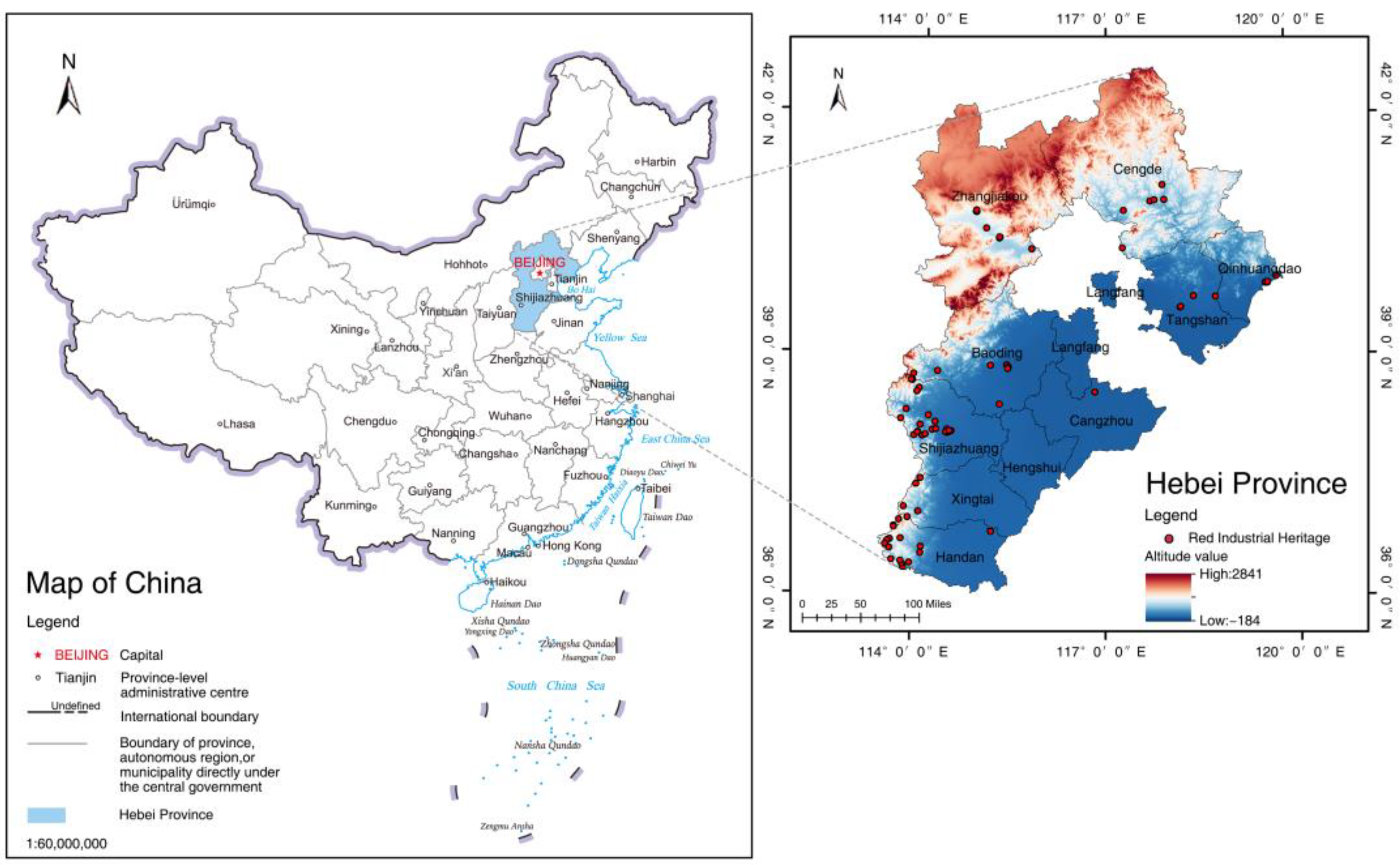
Figure 1. Location map of Hebei Province. Source: Authors’ elaboration. (Base map created from the 1:6,000,000 scale China map with approval number GS (2019) 1651 from the National Standard Map Service Platform; the base map has not been modified).
Sustainability 17 07532 g001
Figure 2. Research framework diagram. Source: Authors’ elaboration.
Sustainability 17 07532 g002
Figure 3. Kernel density distribution of red industrial heritage in Hebei Province. Source: Authors’ elaboration.
Sustainability 17 07532 g003
Figure 4. Spatial autocorrelation analysis of red industrial heritage in Hebei Province. (a) Spatial autocorrelation report. (b) Local spatial autocorrelation (LISA) agglomeration diagram. Source: Authors’ elaboration.
Sustainability 17 07532 g004
Figure 5. (ae) Kernel density distributions during different historical periods. Source: Authors’ elaboration.
Sustainability 17 07532 g005
Figure 6. (a) Standard deviational ellipses for five periods. (b) Mean centers. Source: Authors’ elaboration.
Sustainability 17 07532 g006
Figure 7. Kernel density distribution of different categories of red industrial heritage in Hebei Province. (a) Traffic and transportation. (b) Military. (c) Financial. (d) Mining. (e) Printing and publishing. (f) Power. (g) Chemical and pharmaceutical. (h) Communication. (i) Other manufacturing. Source: Authors’ elaboration.
Sustainability 17 07532 g007
Figure 8. (a) Location-type distribution of red industrial heritage in Hebei Province. (b) Period-type distribution of red industrial heritage in Hebei Province. Source: Authors’ elaboration.
Sustainability 17 07532 g008
Figure 9. The relationship between the development of red industrial heritage and historical events in Hebei Province. Source: Authors’ elaboration.
Sustainability 17 07532 g009
Figure 10. Distribution of natural resources in Hebei Province. Source: Authors’ elaboration.
Sustainability 17 07532 g010
Figure 11. (a) The relationship between heritage sites and the railway positions in 1980. (b) The straight-line distance between heritage sites and the railway. Source: Authors’ elaboration.
Sustainability 17 07532 g011
Figure 12. Topographic map of Hebei Province. Source: Authors’ elaboration.
Sustainability 17 07532 g012
Table 1. The development history of red industrial heritage in Hebei Province.
Historical Stages of the Red Industry in Hebei ProvinceTime PeriodNew AdditionsKey Events
Modern industrial germination period1861–1911221861: Westernization Movement
1900: Eight-Nation Alliance Invasion
1907: Completion of Zhengding–Taiyuan Railway
National industrial turmoil period1912–193681912: Founding of the Republic of China
1921: Founding of the Communist Party of China
1931: September 18th Incident
Wartime industrial forging period1937–1945261937: Full-scale outbreak of the War of Resistance Against Japanese Aggression
1940: Hundred Regiments Campaign
Liberation industrial recovery period1946–194981946: War of Liberation
1949: Founding of the People’s Republic of China
Industrialization foundation and transition period1950–1978161953: First Five-Year Plan
1964: Third Front Construction
Disclaimer/Publisher’s Note: The statements, opinions and data contained in all publications are solely those of the individual author(s) and contributor(s) and not of MDPI and/or the editor(s). MDPI and/or the editor(s) disclaim responsibility for any injury to people or property resulting from any ideas, methods, instructions or products referred to in the content.