1. Introduction
Recent trends in tourism reveal a growing demand for emotionally engaging and experiential holidays centered on connecting with nature, landscapes, and local communities. Increasingly, tourists seek deeper travel experiences, aiming to gain a richer appreciation for destinations and their natural beauty and high-quality landscapes, as well as local identity and culture [
1].
This emerging category of tourism, often referred to as slow tourism, represents a form of sustainable travel characterized by its low carbon footprint and emphasis on taking the time to explore local culture, history, and natural landscapes [
2,
3].
Several studies emphasize the mode of transport, suggesting that slow tourism should be defined by the use of transportation alternatives to cars or planes, such as buses, trains, cycling, or walking [
4]. Slow tourism emphasizes sustainable tourism practices and a slower pace of travel. It encourages mindful exploration of destinations in a responsible way. Thus, slow travel seeks to enhance tourists’ enjoyment of experiences [
5,
6], offering a leisurely travel experience, considered a fundamental aspect of tourism, while simultaneously achieving a substantial reduction in emissions and establishing a viable alternative to conventional “mass tourism” [
5,
6,
7].
Embracing slowness in travel enables a more profound engagement with destinations [
8], fostering a genuine immersion in the landscape as an act of respect for both the environment and the time dedicated to the journey [
9]. Indeed, slow travelers are encouraged to spend more time in cultural, local heritage, and nature experiences, preferably by travelling on foot or bicycle. Ciascai et al. [
10] argue that this sustainable way of travelling offers a deeper experience for the tourist while minimizing environmental impact.
According to Stofflen [
11], cycling and walking have become, in the last decades, a significant tourism phenomenon across Europe. Ancient routes have been rediscovered and promoted as walking trails, offering tourism experiences focused on appreciating and preserving the landscape and culture, and fostering a connection with the local identity of places through direct engagement with the sites [
12,
13].
Cycle routes, with a more recent history of popularity, spanning the last 40 years, have been developed across different distances and spatial scales. In Europe, a number of routes have been implemented, primarily in rural and in well-preserved landscapes, to create an extra regional network to enhance cycling tourism at the European scale [
11], combining rural tourism with the slow philosophy of travel for a non-invasive and sustainable use of space [
14].
As a result, today this kind of tourism offers several opportunities in terms of routes and destinations that are off the main mass tourism routes. Well developed in many European countries, cycling, as a form of slow tourism, prioritizes some key elements: well-preserved environmental and landscape features, alongside rich cultural and social dimensions [
1].
Several studies highlight the potential of cycling routes to fuel the growth of cycling tourism and its subsequent impact on local areas. This impact is primarily seen in the emergence and expansion of cycling-oriented economies along the routes, closely linked to local businesses and, crucially, to the environmental and landscape characteristics of the destinations [
15,
16].
Among local features, landscape is a primary driver for travel, particularly for cyclists, as traversing the territory at a slower pace enhances understanding and appreciation of its environmental and cultural nuances. This deliberate movement through the landscape enhances the sensory experience of the sites and the overall enjoyment of the journey [
17].
Cyclists naturally interact with their surroundings on a physical level. The bicycle, by demanding a heightened spatial awareness and a more conscious management of travel time, plays a vital role in fostering a deeper understanding of places and the human–space relationship for both residents and travelers [
18]. Cycling tourism has obtained its popularity across the world for its benefits to physical/mental health, social connections, and entertainment [
19]. In addition to recreation and health [
20,
21], cycling has other aspects that are much less studied in theory, which represent the main motives of most countries to contribute to cycling development. These are ecological and economic aspects of development [
22].
The EU’s Green Infrastructure Strategy (2019) [
23] underscores the need to strengthen the interconnectedness of natural capital across Europe. Consequently, the quality of green infrastructure (GI), recognized for its provision of ecosystem services (ESs) and its well-integrated and spatially connected nature, significantly impacts environmental conservation and improvement [
24]. Furthermore, the development of pedestrian and cycle path projects, which form a network promoting slow mobility [
25], contributes to the creation of GI, acknowledged as a catalyst for territorial regeneration [
14]. Integrating GI and slow tourism objectives into strategic and spatial planning processes is therefore a crucial priority.
These considerations highlight that the primary motivations for slow tourism, particularly cycling tourism, lie in offering tourists immersive, enjoyable, and secure experiences of the natural environment, landscapes, culture, and local character. From the perspective of ecosystem services, recreation and tourism can be seen as ways in which cultural ecosystem services offer advantages to people through activities and experiences. Specifically, ecotourism is founded on activities and experiences that inherently involve recognizing how nature contributes to human well-being and a commitment to avoid damaging nature through recreational and tourist pursuits [
26]. Furthermore, new cycling paths could innovatively function as green social streets, comprehensively integrating aspects of slow mobility, green infrastructure, and urban forestation within urban and landscape regeneration and redevelopment initiatives [
27].
Consequently, the planning and implementation of cycling routes should adopt integrated spatial and landscape planning approaches aimed at establishing suitable conditions for the routes and the development of related tourism activities. From this perspective, it is crucial to recognize that cycleways and paths are more than just non-motorized transport infrastructure. By creating new connections, accessibility, and territorial hierarchies, as well as enabling new forms of slow tourism, they become integral to land use and are intrinsically linked to environmental and landscape concerns. Therefore, it is essential to envision focused, integrated planning processes that center on shared visions for the future, working in conjunction with regional and landscape planning. These processes should be based on measures aimed at preserving and enhancing cultural, environmental, and landscape heritage, as well as local identity, and adding new value to the areas they traverse.
In the context of the upcoming Magna Grecia cycling route—the southernmost section of the EuroVelo (EV), a trans-European cycling network—this contribution highlights the need to define new development policies that effectively integrate sustainable slow tourism with the protection and enhancement of environmental and landscape values along the coastal areas the route crosses. As the route traverses three southern Italian regions, it is crucial to envision focused, integrated planning processes grounded in shared long-term visions and coordinated with regional and landscape planning. These processes should prioritize measures that preserve and enhance cultural, environmental, and landscape heritage, reinforce local identity, and add new value to the territories involved.
The case study presented here examines a section of the Ionian coastline in Sicily, notable for its significant natural and landscape features that are closely integrated with a densely built environment. In this particular area, these environmental and landscape assets are severely jeopardized by scattered, unauthorized low-density constructions, derelict sites, and other unsuitable developments along the coast. By analyzing the case study, this contribution aims to present a spatially based methodology for assessing the quality and attractiveness of the route according to the European Certification Standards (ECS). The approach combines analysis of environmental and landscape plans with land-use/land-cover data interpretation. Land-use categories were classified by their suitability for cycling, using updated Corine Land Cover data and high-resolution imagery. Landscape value was assessed using regional landscape plans. This integrated method allowed for spatial identification of critical segments and supported planning strategies to improve the cycling experience.
The approach presented involves reconsidering the environmental and local landscape heritage as a potential catalyst for new forms of sustainable development. From this viewpoint, the cycling route becomes a central component in initiating regeneration processes. These processes are then sustained by new beneficial connections between land use and sustainable tourism practices, which are founded on the enhancement and networking of local areas and resources. The paper is organized as follows:
Section 1 introduces the Magna Grecia cycling route as the chosen case study;
Section 2 proposes a method for assessing the route’s attractiveness;
Section 3 and
Section 4 present and discuss the results of applying this method, considering the current literature on urban regeneration, landscape restoration, and sustainability issues.
The Magna Grecia Cycle Route: EuroVelo in the Mediterranean Region
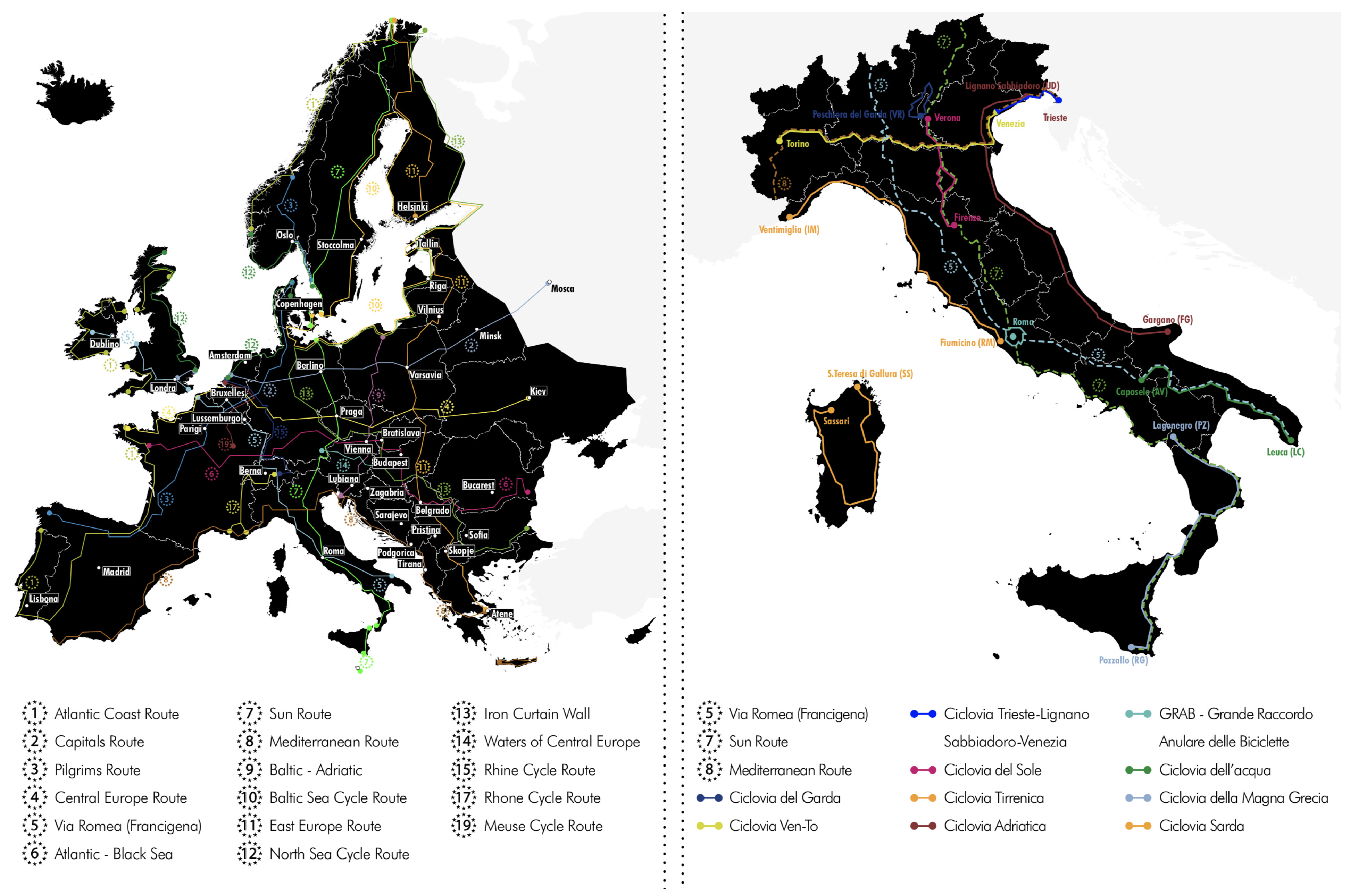
This study focuses on the Magna Grecia cycling route, the southernmost segment of EuroVelo Route No. 7—The Sun Route—which stretches from the North Cape to Malta, connecting a rich network of archaeological Greek sites in southern Italy (
Figure 1).
It forms part of the broader EuroVelo network, a trans-European system of 19 long-distance cycling routes spanning over 70,000 km and linking the entire continent [
28] (
Figure 2).
Developed on behalf of the European Community by the European Cyclists’ Federation (ECF), the network crosses 42 countries, promoting European trans-border cycling infrastructure and supporting soft mobility and sustainable tourism [
29].
More than 70% of the network is located on public roads and only 14% consists of separated bicycle paths or lanes. The network includes existing and planned national and regional cycle routes. Several countries have formally integrated the EV network into their official transport strategies, committing significant financial resources to enhancing cycling infrastructure and providing coordination with their transport development agency, relevant NGO’s and local governments. This level of integration underscores the strategic importance placed on cycling within the European borders. The EV network is envisioned as a ‘backbone’ that connects national and local cycling networks, ensuring a seamless and continuous cycling experience across European landscapes [
30].
The aim of this ambitious project is the achievement of very high quality and safe cycling routes in all European countries, enlarging and completing the existing network, harmonizing standards, and minimizing interaction with motor vehicles. The network is designed with the aim of spreading across Europe a winning sustainable mobility model, and promoting cycling tourism as a practice that can contribute to enhancing health and well-being, but also provide environmental benefit and facilitate contact with nature, landscape and local community [
31].
This initiative aligns with the growing global interest in sustainable tourism and active travel, where the act of cycling transforms the journey into an integral part of the exploration, fostering a deeper connection with the environment and local heritage. The development of such a route caters to a segment of travelers seeking immersive and environmentally conscious experiences, moving beyond conventional mass tourism models [
32]. The aim of the EV network is to encourage large numbers of European citizens to shift to healthy and sustainable travel for daily trips and as cycling tourism. The latter is the challenge of the EV project, according to a successful model that has been proved to increase tourist flows, have economic benefits [
33], and revitalize and preserve the environment and landscape of the involved regions.
EuroVelo programs are implemented in Italy by the Touristic Cycling Routes National System (SNCT), a strategic project designed and supported by the National Ministry of Infrastructure and Transport. The SNCT was planned, according to a National Act approved in 2018, with the aim of setting a national cycling route network, promoting use of bicycles as a non-motorized mean of transport, and providing the basic infrastructure for cycling tourism.
In the framework of this act, the Magna Grecia cycling route was designated as the southernmost section of the Sun Route, which begins in Lagonegro (Potenza) and ends in Pozzallo (Sicily). It is conceived as a journey through the heartland of ancient Greek colonization in Southern Italy, connecting a string of significant archeological sites and valuable landscapes across Basilicata, Calabria, and Sicily.
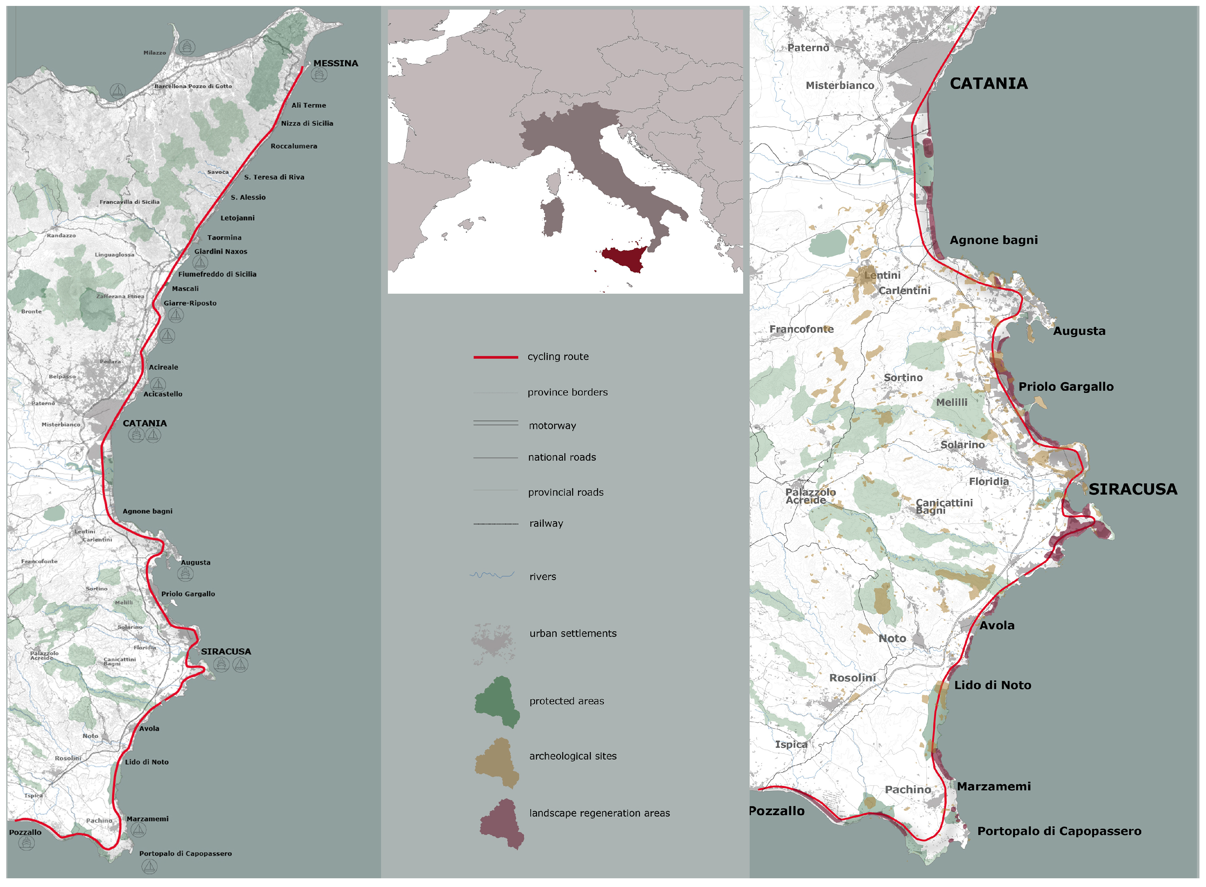
While the complete route spans three regions, the research has specifically focused on the 266 km Sicilian segment, which begins in Messina and culminates in Pozzallo, marking the southernmost point of mainland Italy.
The first design document highlights the planning criteria for the Sicilian portion of the route. The document proposes a path that runs along the Ionian coastline through four provinces (Messina, Catania, Syracuse, and Ragusa) and connecting three metropolitan cities, including Messina and Catania, as well as 32 medium and small cities, thereby offering a blend of urban exploration and immersion in smaller, less-known landscapes and local communities.
The planned cycle route will run through an area characterized by relevant morphological and environmental sites as well as areas with significant landscapes values that are intertwined with a high-density built environment. However, those values are heavily threatened by irregular low-density settlements, decayed areas, infrastructures, mainly roads and railroads, a massive petrochemical district—one of the main coastal industrial sites in Europe—and other settlements scattered across the entire coastal area.
Despite the many critical issues, the Ionian coast still maintains a valuable structure, characterized by environmental, landscape, and cultural values, that forms its prevailing character.
In detail, the area is characterized by the presence of a number of historical cities, UNESCO sites, valuable archaeological settlements, and a number of protected environmental sites, such as costal and marine environment, river mouths, wetlands, geomorphological emergencies, and many other environmental sites that are rarely concentrated in a such a short stretch of coastline [
17] (
Figure 3).
This surprising palimpsest of cultural heritage and environmental sites, rich in landscape values, will be connected by the cycling infrastructure in a continuous path, accessible, potentially integrated with other valuable sites in inland areas, and capable of activating regeneration processes, new land use, and new values related to sustainable slow tourism activities [
34].
On the other hand, the Ionian coastline is also characterized by a number of urbanized areas spread along the coast, especially close to the main cities of Messina, Catania, and Syracuse. The result is a large conurbation that embraces, almost continuously, the entire eastern coastline of the island.
Messina and Catania, the two metropolitan cities, and Syracuse form an almost continuous coastal conurbation in which are concentrated about two million inhabitants, compared to five million in the whole of Sicily [
35]. Encouraged by the spread of private cars and low real estate prices, this low-density urbanization has both generated serious congestion and exploitation that have badly affected the fragile coastal landscape [
36].
The planned cycling route must therefore take in account the relationship with the built-up areas along the coastline, as well as its morphological, environmental, and landscape features. Thus, it will be necessary to take into account all the elements that characterize the coastal environment, such as forms of urbanization and related land uses, landscape values, and environmental sites in order to identify the most suitable paths, capable of reconnecting interrupted environmental and landscape plots and generating new places and new opportunities for a slow sustainable tourism based on enhancement and conservation of the coastal environmental, landscape, and cultural resources and local identities.
In such a complex land-use scenario, characterized by environmental and landscape values mixed with damaged landscape and environmental degradation, the planned Magna Grecia cycling route will shortly be built according to European planning strategies and design models developed and shaped for northern Europe, whose spatial contexts are characterized by different land-use regulations models, and landscape and environmental protection policies.
On the contrary, in the discussed case study, the planned cycling route will be realized in an unprepared area which shows clear gaps concerning regional planning as well as weak landscape and environmental protection policies [
17].
Moreover, the dramatic anthropic pressure on the coastal zones, which is threatening their fragile environment and landscape, and awareness of the need to adopt sustainable measures to reduce the negative impact of natural phenomena, necessitate research into proper measures and a specific integrated approach, taking into account diversity and specific needs related to the physical and social economic characters of the interested areas.
This is in order to avoid the new cycling route becoming just another unfeasible and poorly integrated element in a congested, unsettled, and damaged coastal landscape.
2. Materials and Methods
To evaluate the quality level of the cycling route and how appealing the travel experience would be, this research employed a combination of qualitative methods, including examining environmental and landscape plans’ contents, with the concurrent observation of the scenery while cycling, and analyzing data on land use and land cover.
In the European context, the standards used to check the quality of EuroVelo routes are outlined in the European Certification Standards (ECS) evaluation manual [
37]. The route’s attractiveness is regarded as one of the most significant quality criteria established by the ECS, and it is directly related to the presence of certain conditions:
Essential conditions—such as the existence of at least one noteworthy cultural or natural site on a daily segment of the route. This condition can also be fulfilled by considering the proximity to a highly attractive landscape.
Important conditions—pertaining to the route’s exposure to environmental pollutants, such as dust, noise, or odor (no more than 25% of a daily portion).
Additional conditions—related the aim of minimizing monotonous stretches on the route, ensuring that no more than half of any given day’s section involves such surroundings. Additionally, the route must prioritize user safety by avoiding social safety challenges and other hazards.
According to the ECS, the attractiveness of the route depends on the surrounding landscape; it can be defined as follows:
Monotonous/unattractive if it is made up of endless suburbs, shopping centers, plants, and warehouses;
Attractive if it is characterized by forests, meadows, fields with some particular features such as hills or trees, tree-lined roads;
Highly attractive, if it offers features such as sea views, panoramic vistas, cliffs, canyons, natural landscapes, and historical cities.
Other certification criteria, more related to physical aspects of the route components, such as the continuity or signing, are also important to define the quality of the route and provide comparisons among cycle route networks. However, for the purpose of this study, which is focused on the relation between the route and the spatial landscape dimension, the attractiveness criterion is considered the most important proxy of the route’s quality level, directly influencing the overall cycling experience.
This study applies a method to assess the quality level of the Magna Grecia cycle route based on attractiveness quality criteria resulting from the spatial combination of land-use/land-cover categories with landscape, environmental, and cultural values, all analyzed in the proximity of the path.
Thus, an overlay analysis between the landscape plans’ provisions and the land-use/land-cover categorization is carried out in a GIS environment (QGIS Desktop 3.44.0) and serves to define the attractiveness of the path. Employing a primary focus on the attractiveness evaluation criterion is paramount to cultivating a positive and engaging cycling experience along touristic routes. This necessitates the strategic design of routes that facilitate seamless interconnection between aesthetically pleasing landscapes, significant cultural landmarks, and notable natural sites, while concurrently ensuring secure and free transit.
Therefore, the proposed methodology proves to be valuable in discerning deficiencies in the attractiveness of cycling routes and in exploring design-oriented solutions to address crucial issues that could detrimentally influence the overall quality of the cycling experience. Indeed, the resulting spatial analyses allow for mapping the spatial distribution of criticalities along the cycling path; and providing data to inform planning strategies for prioritized intervention areas, to enhance the overall attractiveness of the route.
2.1. Land-Use Analysis
The analysis of land use was carried out based on the update of the Regional Land Use Map according to Corine Land Cover, scale 1:10,000, which was defined according to the criteria of the Corine Land Cover (Manual of the European Community), and released by the Regional Government in 2008. Photo interpretation of available high-resolution regional orthophotos (4-band digital orthophotos (RGBI) with a ground resolution of 0.25 m, taken over the entire territory of the region, including islands with a cartographic cut at a scale of 1:10,000, ATA flight 2012–2013) and the most recent Google Maps images was performed to check and update the land-use classification.
Five main land-use categories were identified in the case study area. Subsequently, each category underwent an evaluation to determine its degree of compatibility with the establishment of a cycle route, classified as “suitable”, “partially suitable”, or “unsuitable” (
Table 1).
Categories 2 through 5 are representative of rural and natural environments. Consequently, these can be uniformly classified as totally suitable land-use categories, owing to their characteristic landscape attributes.
Conversely, the “artificial surface” category encompasses prevalent land uses associated with the built environment. This category should be generally considered “partially suitable”; however, the compatibility of specific sites within this category necessitates a more granular classification into subcategories (1.1, 1.2, 1.3, 1.4, 1.5), as elaborated in
Table 2.
The subcategories of artificial surfaces pertaining to industrial and commercial sites (1.2), and mines, dumps, and other construction sites (1.3), were classified as unsuitable. Conversely, artificial vegetated areas (1.4) and archaeological areas (1.5), by virtue of their undeveloped nature, were deemed suitable.
The urban fabric category (1.1) exhibits a higher degree of complexity, leading to its classification as partially suitable. Indeed, the diverse potential uses within the urban fabric necessitate further specification. As detailed in
Table 3, continuous urban environments, green areas, and sports facilities, along with discontinuous rural settlements and road and rail networks, were considered suitable. In contrast, other subcategories, primarily associated with infrastructure, were classified as unsuitable. Similarly, the discontinuous urban fabric, predominantly characterized by low-density residential settlements, was deemed unsuitable.
2.2. Landscape Evaluation
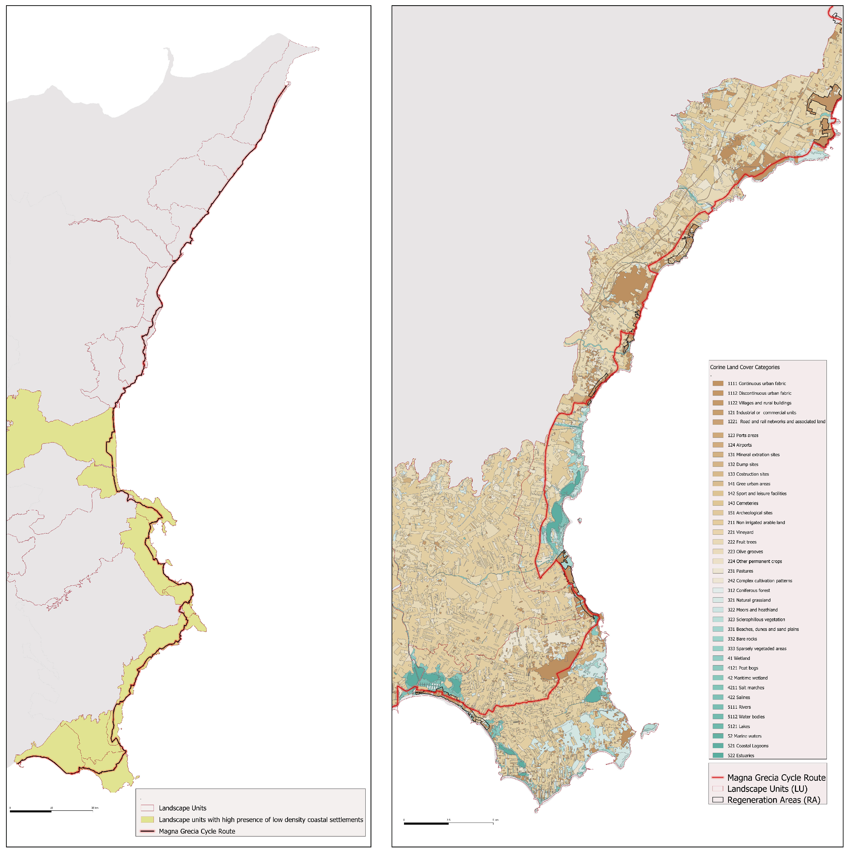
This study integrates suitability attributes derived from land-use analysis with comprehensive landscape data provided by the regional government of Sicily, along with specific directives from provincial landscape plans. The analysis focuses on the entirety of the cycling route. The landscape plans categorize local landscapes into units based on their predominant characteristics. To safeguard and enhance landscape values, these plans define four distinct protection levels. These levels are determined by existing landscape values, the presence of protected natural areas, and other sites subject to landscape protection regulations. For instance, the highest protection level (Level 3) applies to areas of exceptional landscape value and strictly prohibits any land transformation. Conversely, for degraded landscapes, characterized by a complete absence or scarcity of landscape values, the plans outline a regeneration strategy. This strategy involves implementing detailed landscape plans within designated regeneration areas. Notably, several of these areas are situated along the coast, specifically in the most dilapidated coastal settlements.
3. Results
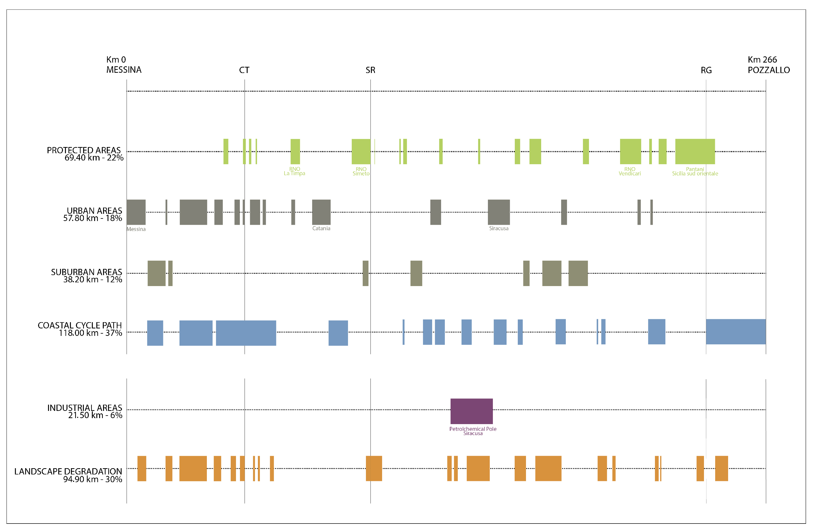
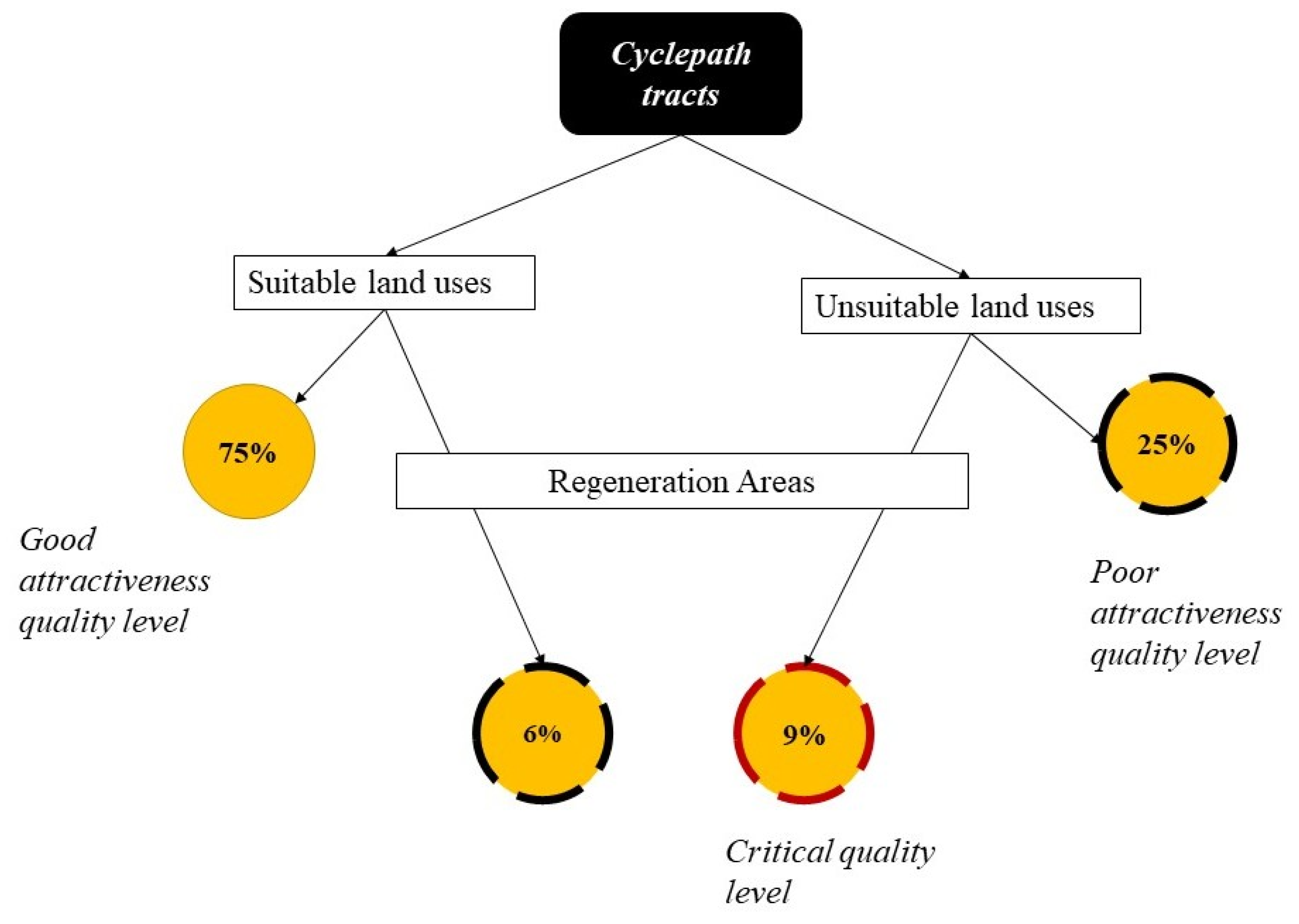
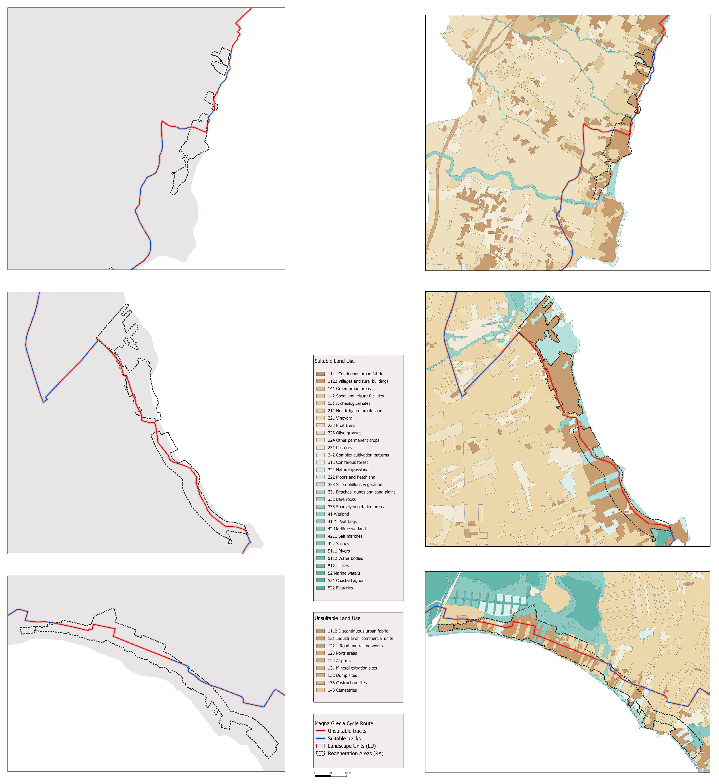
Regarding the land-use suitability issue, our analysis revealed that out of the cycling route’s 266 km length, 199 km (75%) is situated on suitable land, while 67 km (25%) traverses discontinuous urban fabrics and industrial and commercial units, which are classified as unsuitable land uses. The latter comprises 61 distinct sections, varying in length from 101 m to 4.2 km, mostly located in the Syracuse area. There, significant portions of the cycling route pass through poor-quality areas, such as low-density settlements scattered along the coast, a major petrochemical hub, and numerous minor commercial and artisanal settlements primarily spread on the periphery of major cities.
Regarding the landscape evaluation, our analysis showed the cycling route crossing 19 distinct landscape units (LUns) that span the entire coastline from Messina to Pozzallo. Each unit possesses unique landscape value and disvalue. According to data provided by the available landscape plans, low-density coastal urbanization, intensified by tourism exploitation, triggers the risk of further degradation for at least 10 out of 19 landscape units, with potential serious impairment of coastal landscape values.
Figure 4 shows the landscape units and land uses crossed by the cycle route, with reference to the entire stretch of Sicilian coastline concerned and the portion south of the urban center of Syracuse, where the presence of areas of lower attractiveness is more frequent.
The combination of both spatial analyses highlighted a two-tiered level of unsuitability in 23 segments of the route, totaling over 37 km. In fact, these portions are planned within discontinuous residential areas or industrial land uses and, at the same time, fall within the boundaries of designated landscape regeneration areas. Here, municipalities can implement detailed regeneration plans. Namely, the route crosses 22 regeneration areas (RAs) over a total of 47 identified within the 19 local LUns.
Fifteen percent of the cycling route (38.93 km) falls within regeneration areas for dilapidated landscape restoration according to the indications of the landscape plans.
Twenty-five percent of the cycling route (67 km) is found to fall within areas with land uses unsuitable for the passage of a soft mobility infrastructure due to their lack of attractiveness.
Nine percent of the cycling route (24.12 km) crosses unsuitable land uses and landscape regeneration areas at the same time.
While areas with suitable land uses outside the boundary of RAs do not present criticalities for attractiveness of the route, areas with unsuitable land uses or areas with suitable land uses but crossing RAs represent weak points of the route in terms of quality.
If the tracks of the route cross unsuitable land uses included in RAs, then they represent the weakest links in terms of attractiveness, potentially being a severe detriment to the overall cycling experience, and should be considered for priority of planning and design actions for landscape enhancement and attractiveness, as discussed further in the following (
Figure 6).
4. Discussion
The segments on the coastline, while part of the cycling route to be implemented, often lack attractiveness due to current land uses and/or dilapidated landscapes. As in the premises, these conditions could result in diminishing the overall slow tourism experience and must be addressed according to different levels of priority to enhance the route’s appeal.
In these contexts, though they are not inherently predisposed to slow tourism due to their morphological, anthropogenic, and socio-spatial characteristics, the development of design strategies and tools that actively promote “slowness” as a foundational model, both at regional and landscape planning levels, could become a crucial strategy, since integrating slow tourism and cycling tourism as environmentally conscious modes of exploration fosters deep connections with nature and local communities [
38]. Within this vision, the cycling route transcends its function as mere infrastructure; it becomes a pivotal element of a revitalized landscape. Namely, the core idea of the research lies in interpreting the cycle path as a planning and design tool for landscape restoration. In other words, the action of sewing ecological and cultural connectivity by the spatial development of the cycle path and targeting the multifunctionality of ecosystems through slow tourism is consistent both with EU guidelines and with the local context of the Magna Grecia route, characterized by a polycentric landscape. In the proposed methodology, we combine the investigation on land uses and landscape features with the potential planning and design role of a slow tourism mobility action.
Limits of this approach might be found in the use of land-use/land-cover maps as the only supporting study to evaluate the level of attractiveness along the route based on landscape plans’ categorizations. A number of other indicators and or spatial analyses could have been used to qualitatively or quantitatively assess the quality level all around the cycle path. However, since the most immediate and evident outcome of planning instruments is the modification of land uses, it was considered that the first factor to be investigated and on which to base planning strategies was precisely the current structure of land uses in the areas affected by the passage of the Magna Grecia route. Moreover, limitations or biases in attractiveness evaluation based on land-use classifications and qualitative judgments on landscape values do not solve the case of landscape aesthetics and similar issues, which are the most commonly investigated but least formalized issues in the scope of the ecosystem services concept [
39].
To introduce new functions and land-use categories that will resonate beyond spatial dimensions, influencing the cultural, economic, and social fabric of the traversed regions, spatial planning tools at various scales—from land use to landscape and mobility—is paramount. They are also the framework for formulating appropriate policies and relating mechanisms for landscape regeneration, ultimately enhancing the significance of the cycling route and cycling tourism as a whole [
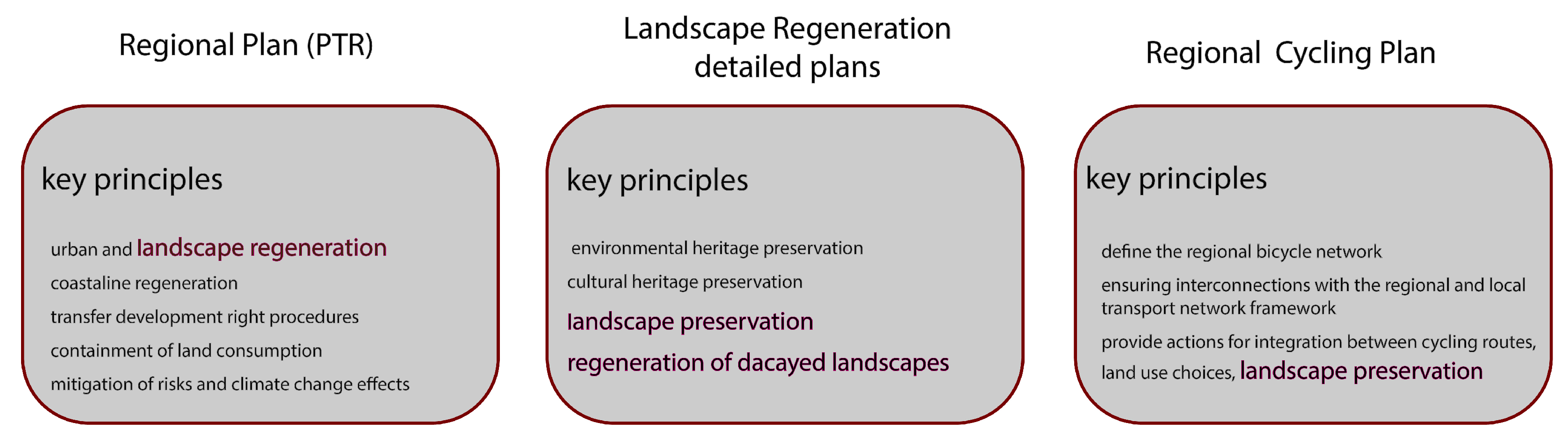
40]. A review of the key principles under the implemented or under-development plans could help in understanding how to unlock their full potential in order to conveniently define a proper approach to land-use and landscape regeneration for the blighted and dilapidated areas (
Figure 7).
To create the right conditions for redefining the coastal environments with the introduction of new forms of slow tourism, planning ideas, according to different scales, should be defined by focusing on an ecological transition process based on the reduction of anthropic pressure, and thus congestion, along the coastline, the restoration of environmental and landscape values, and the mitigation of risks.
At the regional scale, the Spatial Regional Plan (PTR) establishes the vision for the regional development aimed at preserving and enhancing Sicily’s natural, cultural, and environmental heritage [
41]. The basic principles are closely aligned with existing landscape protection plans and reflect their core values.
More specifically, through its strategic focus on accessibility, landscape and environmental protection, and urban settlements, the PTR plays a crucial role in safeguarding and promoting the region’s landscapes. Its structure is built around specific challenges, each rooted in well-researched macro-themes that form a solid knowledge base for planning scenarios.
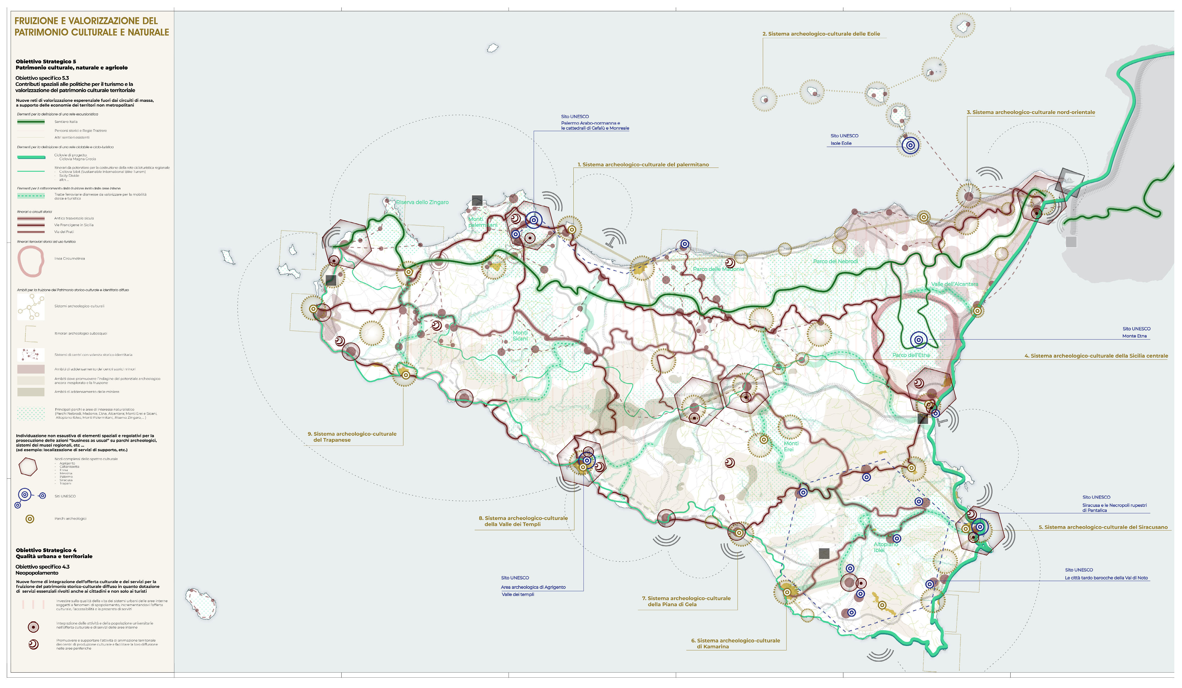
Among these challenges, one key focus area is the promotion of non-motorized mobility as a tool to foster sustainable tourism, particularly in inland areas of Sicily. The plan envisions a network of cycling and walking routes that connect the island’s natural, cultural, and landscape assets (
Figure 8).
This initiative encourages slow, meaningful travel that supports both environmental conservation and the revitalization of rural areas.
Notably, the PTR’s vision goes beyond simply creating a network of non-motorized routes. It also seeks to preserve cultural heritage, stimulate slow tourism, support local entrepreneurship, and restore threatened landscapes, while simultaneously improving access to cultural landmarks and experiences. By integrating accessibility with the appreciation of both urban and natural environments, the PTR enhances Sicily’s appeal for tourists and residents alike.
A keystone of this strategy is the development of experiential slow tourism networks to boost local economies in non-metropolitan areas. This includes the creation of hiking and cycling trails, and improved access to inland areas through non-motorized transport modes. The plan emphasizes the integration and promotion of Sicily’s rich cultural, historical, and natural heritage by connecting key archaeological sites, historic towns, and protected landscapes into a unified network.
Within this framework, the Magna Grecia cycle route will serve as a backbone of the regional mobility strategy, helping to establish a strong island-wide network for slow and sustainable tourism.
According to these principles, the PTR also outlines strategies for coastal recovery, aiming to balance spatial dynamics between coastal and inland areas [
34]. A major focus is put on enhancing accessibility and mitigating the negative effects of mass tourism, particularly coastal congestion. Additional strategies address environmental and landscape concerns, ensuring strong protection measures for the ecological, cultural, and scenic values of Sicily’s coastline. In this context, non-motorized mobility is identified as a key driver in the recovery and restoration of coastal landscapes.
Starting from the provision of existing landscape plans, the PTR identifies further areas in need of detailed regeneration and provides guidelines for strategic planning and design tools. It also includes regulatory measures for land use next to the cycle routes, aiming to reduce conflicts and increase the attractiveness and functionality of the routes.
As such, the PTR is the most appropriate instrument to address current challenges related to land use along several sections of the cycling route. By positioning the route as a unifying element in shaping a coherent vision for the Ionian coastal landscape, the PTR can trigger a real process of regional and landscape regeneration, driven by the principles of slow mobility.
The Landscape Regeneration Areas
Concerning the less attractive parts of the route in landscape regeneration areas, with the presence of dilapidated landscape or a lack of landscape value, the implementation of detailed landscape plans can represent a successful way to rethink landscape features thanks to the implementation of the new cycling route.
Such plans, on the base of existing values, can serve as catalysts for spatial and environmental regeneration, aligning with regional and landscape planning directives and emphasizing the management of cultural and environmental heritage in coastal regions.
According to this vision, these detailed plans should articulate strategies and tools aimed at rehabilitating decayed landscapes, redefining urban design, and revising land-use categories. The objective is to enhance the role of the cycling route as a strategic tool for promoting sustainable tourism and green development along the coastline.
The detailed landscape regeneration plans will include specific tools and rules oriented to activate economies to support the plans’ implementation. For instance, the planning tools should include ecological land compensation, the transfer of development rights and development credits, development incentives to promote nature-based solutions, green infrastructure, and landscape refurbishments. All strategies and tools must be supported by participatory processes aimed at sharing planning visions and establishing cooperation and partnership between public and private actors.
In addition, the reassessing of coastal land use, and in particular coastal urbanization should take into account the complex phenomenon of illegal settlements and, in particular, their social, economic, and administrative effects [
42].
Thus, the plans should also provide an incentive for demolition of illegal buildings built in high-risk areas, also providing specific planning tools for their replacement.
Moreover, planning efforts have also to consider the economic value of seaside tourism, which is the most prominent sector in Sicily and could, alongside the development of the new cycling path, serve as a backbone for emerging development policies aimed at promoting slow tourism along the coast. In this context, long-distance routes—continuous and exclusively designated for bicycles and pedestrians—constitute a fundamental prerequisite for the advancement of cycle tourism. One of the key drivers behind the success of such tourist cycle paths is the quality of the infrastructure, which enables cyclists to travel in safety and with confidence [
43].
Accordingly, urban, regional, and landscape plans should incorporate regulations guided by a market-oriented approach, offering incentives for tourism-related interventions in exchange for contributions to the redesign of urbanized areas. These efforts should emphasize both the enhancement of landscape values and the appeal of the cycling infrastructure.
The implementation of the new cycling path represents a crucial opportunity to develop integrated design strategies and tools that consider the relationship between land-use planning, cycling infrastructure appeal, and broader landscape enhancement. These strategies should aim not only to strengthen seaside tourism, but also to foster new forms of slow tourism connected to environmental, landscape, and cultural assets.
The success of the coastal regeneration process will largely depend on the establishment of targeted planning tools designed to create incentive-based compensatory mechanisms. These mechanisms are essential for generating the additional economic value required to implement the plan. Such mechanisms may involve the transfer of undeveloped land to facilitate the creation of new public spaces that enhance accessibility and public use of the coastline. Furthermore, they can enable the development of services and infrastructure—such as accommodation, public facilities, and retail spaces—aligned with the promotion of slow tourism.
To support this, it will be crucial to integrate planning tools aimed at mitigating landscape impacts. These may include greening initiatives, ranging from simple green buffers in urban areas to wooded corridors, and other forms of nature-based solutions and green infrastructure. The plan should also identify new development zones to accommodate cycle tourism-related activities.
The regeneration of coastal settlements must foster spaces of coexistence that balance the needs of local residents with the demands of slow tourism. Coastal areas, enriched by their landscape and environmental assets, must be made accessible and equipped with essential services to attract and retain cycling tourists.
The proposed interventions will take into consideration existing local economies, particularly those tied to the seasonal rental market. These can be effectively leveraged through targeted improvements in both the built environment and the ecological and landscape dimensions. Such an approach may significantly increase the feasibility of transformative initiatives aimed at enhancing urban and environmental resilience in these areas.
Ultimately, the core challenge lies in developing effective design and planning tools that support a genuine ecological transition—integrating landscape and environmental protection with risk mitigation and adaptation policies, while simultaneously promoting slow tourism practices. This emerging condition represents a unique opportunity to catalyze meaningful improvements in coastal settlements and steer their transformation toward resilience. The cycleway and associated cycle tourism infrastructure can serve as anchors for this transition, converting current vulnerabilities into resilient and sustainable futures.
5. Conclusions
The present study established a conceptual framework of analysis to evaluate the attractiveness of touristic cycle routes, considering environmental, landscape, and land-use issues.
In detail, by comparing land use and landscape features, the research presents a method to assess value and disvalue on the base of “attractiveness” as defined within European Certification Standard for EuroVelo cycling routes.
This approach is considered fundamental in areas that are potentially jeopardized by the duality of environmental, ecological, and natural cultural values in alternation with disvalue or threats such as dilapidated landscapes, congestion, unfitted land uses, and economics models.
Under these conditions, the implementation of a touristic cycling route might pose risks related to its attractiveness, compromising the success of the route and the slow tourism approach as a whole.
In response, the study identifies the planning conditions necessary to mitigate such risks, emphasizing coordination across regional and landscape planning and policy tools. The analysis is presented with regard to a case study that is undoubtedly unique in Europe for landscape and environmental features alternating with critical issues.
The results clarify the importance of multiscale planning tools in reinforcing the relationship between land use, landscape, and cycleway and in supporting landscape recovery processes.
This research also outlines a landscape design approach oriented to create synergies between cycling routes, slowness, and new forms of landscape preservation.
Therefore, the main goal is related to the introduction of widespread design strategies, tools, and actions in regional and landscape plans and projects, aimed at promoting slowness as a model, even in contexts that are not always suited to slowness due to morphological, anthropic, and socio-spatial characteristics.
As a consequence, the cycling route becomes a fundamental part of the landscape and should be considered as a component of regeneration projects able to introduce new functions and new forms of land use that have impacts not only on the spatial dimension but also on the cultural, economic, and social dimensions of the crossed areas.
According to this approach, the cycling route becomes a key element of a project oriented to preserve natural and cultural heritage and restore the coastal landscape.
Thus, it will be necessary to overcome the car-centric vision in favor of new cycling routes taking a leading role, able to impose non-negotiable hierarchies and uses both at the urban and regional scales [
44].
Consequently, the upcoming implementation of the route cannot remain a simple infrastructure project, as currently planned and funded by the national government. Instead, it must be integrated into a broader regional and landscape regeneration strategy that supports slowness and sustainable coastal slow tourism.
The proposed planning and design approach could be a big opportunity for slowness in Sicily, whose coastal areas could become a laboratory of landscape and environmental design related to cycling routes and cycling tourism themes.
Based on the findings of this study, there are several improvements that should be made both in cycleway planning and in landscape and land-use planning. Efforts should be put into defining specific planning and design tools oriented to maximizing cyclists’ recreational benefits during the travel experience [
45].
In detail, some recommendations for planners and policymakers could be as follows:
- -
Embed cycling infrastructure in broader regional and landscape strategies to ensure coherence with ecological and cultural context;
- -
Develop and implement specific land-use and design tools that prioritize cycling experience and recreational quality;
- -
Recognize cycling routes as a strategic tool for landscape regeneration, aligning them with long-term goals of slowness and sustainable tourism.
This methodology could represent a useful opportunity to set up a landscape design approach characterized by strong ecological and environmental inputs, oriented to enhance the coastal environmental values.
It presents a valuable opportunity to reactivate landscape aligned with planning goals and support the protection of the cultural and environmental heritage of the coastal areas. In this vision, the cycle route acts as a connective element that can reimagine the Ionian coastal landscape through the integrated and sustainable lens of slow tourism.
This research highlights that the careful and reasoned design of tourist cycling routes involves several spatial and social factors. It requires spatial policies that encourage the concentration of spatial opportunities along the route, as well as strong planning efforts to create priority for cyclists and to provide a safe, comfortable, and attractive travel experience [
46].


