Article

The Playground for Radical Concepts: Learning from the Tussengebied

Department of Architecture, University of Florence, 50100 Florence, Italy
Sustainability 2023, 15(8), 6958; https://doi.org/10.3390/su15086958
Submission received: 7 March 2023 / Revised: 4 April 2023 / Accepted: 10 April 2023 / Published: 20 April 2023
(This article belongs to the Section Sustainable Urban and Rural Development)

Abstract

:
The rise in the issue of the metropolitan dimension in the last decades has sparked new needs to conceptualize vast urbanized territories and develop a structured reflection on the various forms of urban–rural relationships. Urban planning in general and metropolitan planning in particular have shown difficulties in properly conceiving and interpreting these needs, which have often led urban discourse toward the use of spatial concepts. The aim of this article is thus to explore the use of spatial concepts as design instruments in the definition of urban–rural relationships in metropolitan areas. Starting from the case study of the Tussengebied (literally area-in-between) in The Netherlands and its reinterpretation developed by three eminent urbanists, the article intends to investigate, through the application of a methodology based on learning-from-expert-knowledge, how spatial concepts can support urban planning governing the urban–rural relationship by proposing a precise form of territory as well as presupposing the rules, modes of operation, and instruments of transformation.

1. Introduction: The Use of Spatial Concepts in the Metropolitan Planning

Urban–rural interface is one of the most debated planning topics of the 19th century. Metropolitan planning at the European level was conceived in the first half of the 20th century, aiming to manage the development of a compact city following a process of urbanization associated with the demographic increase caused by immigration processes. The growing concern about the urban–rural interface driven by the rapid and seemingly random development of cities [1] and the problems of urban fragmentation and urban fringes [2] led toward the end of the millennium to a search for strategic tools and perspectives for fringe territories, which was also due to the raising awareness toward the issue of sustainable development. Metropolitan realities, in particular (e.g., Refs. [3,4,5]) were seen as an entity superior to individual urban centers and therefore better able to govern the coordination and design of the interface between urban and rural. Metropolitan planning thus became a useful tool to coordinate vast territories through strategic plans, as often referred to in various European reforms [6,7]. These reforms marked a turning point in the conception, role, and instruments of metropolitan cities seen as an engine for the country’s institutional and economic renewal; examples include the SRU in France or 56/2014 in Italy [6]. From the late 2000s, metropolitan planning shifted its attention from the spaces of post-metropolitan territories [8] to the so-called 21st-century city [9], in which the classical conception of the city is lost, and where the urban–rural contraposition vanishes in favor of a variegated and multi-scalar conception [10,11].
In this evolving context, urban planning in general and metropolitan planning in particular have shown difficulties in properly conceiving and interpreting the renewed notion of the urban and rural relationship [2,12]. On one hand, several international institutions have attempted to classify the current urban setting on measurable criteria through an almost deterministic approach. One illustration is the development of specific studies by the European Union and the OECD to identify and categorize the urban configurations of European metropolitan and regional systems with a focus on functioning urban regions known as metropolitan (metro) regions [13]. The report “The State of EU Cities” [14] proposes a hybrid definition that takes into account both the administrative and demographic dimensions by dividing metropolitan regions—proposed as urban areas with more than 250,000 inhabitants or NUTS3—into three typologies: capital city regions, second-tier metro regions, and smaller metro regions, depending on whether or not they include the capital city or other globally renowned cities. On the other hand, in several urban studies [2,15,16,17], metropolitan areas have started to be considered not as a collection of enlarged cities and villages, but as a new form of city. These alternative interpretations do not follow quantitative analyses based on the demographic dimension or administrative configuration; they are based instead on the explorative and mediatory capacity of the design approach [18]. The development of this different point of view is grounded in the ability of the design to prospect, read, and examine in context, gather knowledge as well as connect and organize the plan and process [19] and is often based on the use of spatial concepts that can be intended as linguistic devices—metaphors or oxymorons—meant to propose a specific interpretation of phenomena and issues that otherwise would be hardly explicable [18,20] such as urban dispersion and the fragmentation of the urban–rural interface. Among these, rurbanization, diffuse city [21], city of cities [22], horizontal metropolis [23], fractal city, metropolitan archipelago [24], and Zwischenstadt [2] are just a few examples.
The literature offers a vast body of theories related to the role, performance and evolution of the use of spatial concepts in urban planning [20,25,26]. Spatial concepts are considered a key ally in the construction of decision-making [26,27,28,29], structuring discourses [30], and in coagulating the interest and sponsors around them [31]. Spatial concepts serve to enable one policy over another, in addition to explaining some contemporary facts and portraying socio-cultural processes [32,33], orienting planning choices, and communicating them more effectively [34,35]. Thus, the role of spatial concepts has emerged fully in the definition of complex and elusive entities such as urban–rural relationships in metropolitan territories [36].
The aim of this article was thus to explore the use of spatial concepts as design instruments in the definition of urban–rural relationships in metropolitan areas. Based on a learning-from-experts-knowledge methodology, in the article, three spatial concepts, developed by three prominent urbanists for the same area of the Tussengebied in The Netherlands, were compared. This area, from the 80s onward, became for many authors a playground in which to express radical visions and urban concepts, fundamentally questioning the prevailing interpretations of the urban form coined in a dichotomy of “red” and “green”, or “built” and “open” intrinsically related to the Randstad metaphor [37]. In the conclusions, the notions learned will be extracted and possible paths for further study will be highlighted.

2. Theoretical Framework and Methods

This study focused on learning-through-comparison in spatial planning to explore the use of spatial concepts as design instruments in the definition of urban–rural relationships. Learning-through-comparison is a class of methods in theory building that is meant to create a dialogue with the established literature without identifying with a single existing theory [38].
Within learning-through-comparison, four modes of learning for governance and planning systems are distinguished: learning from the past; learning from other places (comparative learning); learning from experts and expert knowledge; learning through dialectic engagement (discussion) [38,39,40].
This study focused on the learning-from-experts method that became widely used in the second half of the 20th century following the work of Kendall [41], and is today considered to be one of the most appropriate for collecting, analyzing, and evaluating information [42,43], especially when dealing with planning.
It is often suggested that a defining feature of planning is its operative nature, which requires connecting knowledge to action [44]. In this sense, planning is conceptualized as a practice of knowing [44,45], and the planner as a reflexive practitioner [46]. This conception requires shifting the focus from knowledge as something that planners have to knowledge as something that planners do.
To reach this knowledge, learning-from-experts seems to be a valuable methodology as it can spark understanding, bring change, and induce learning [40,47] not only in the content of what is offered, but also in the manner in which it is offered [39]. Central to this method is the role of experts—consultants, academics, and highly recognized practitioners—that act as mediators or connectors [48] between knowledge and action [44]. Experts are meant to articulate, explicitly or implicitly, knowledge and action as recursively interlinked [49].
To analyze planning as a practice of knowing and to deepen the use of the learning-from-expert method, this study used the four survey categories indicated by Davoudi [44] to understand the complex interrelationship between knowledge and action: knowing what (cognitive/theoretical knowledge), knowing how (skills/technical knowledge), knowing to what end (moral choices), and doing (action/practice).
The article compares the work of three prominent urbanists, as summarized in Table 1, that proposed three different spatial concepts to interpret and design the same area of the Tussengebied in The Netherlands. Their work was analyzed through the study of documents and publications cited in the article and through three interviews conducted by the author (the three interviews were conducted by the author on the following dates: 21 June 2011, Willem Jan Neutelings; 13 July 2015, Floris Alkemade; 16 June 2015, Frits Palmboom. The full version of the interviews can be found in [50]).
To explore the capacity of their work to clarify the urban–rural interrelation, this study used the categories presented by Davoudi [44], adapting them as follows: “knowing what” was conceived in this study to explore how different urbanists interpreted the definition of the boundary between urban and rural and establish the relationship between these two categories; “knowing how” examined what tools urbanists used to establish, interpret, and design this relationship; “knowing what end” investigated the design purposes for which a spatial concept and a specific strategy were chosen; “doing” explored the operational results of the three different projects, clarifying what physical repercussions they could have on the territory.

3. Results: Learning from the Tussengebied

3.1. The Dutch Planning Context

To understand the territorial condition of the Tussengebied, it is crucial to relate it to the official Dutch urbanization policies, especially concerning what these policies foresaw for the urban–rural relationships. Notwithstanding changes over the years, Dutch planning has always attempted to find an equilibrium between two extremes: urban concentration on one hand, and drastic de-concentration on the other, between the concept of a centralized megalopolis and sprawl. In the Second National Spatial Planning Report of 1966 [51], through the use of diagrammatic schemes (Figure 1), three possible urbanization patterns were presented. The first two, like dystopias, clarified the fears above-mentioned: extreme urban concentration and urban dispersal. In between lies the most famous planning concept developed in The Netherlands: the “concentrated de-concentration” oxymoron. This concept became the leitmotif to promote the creation of green, mid-sized living environments: housing in moderately dense neighborhoods, new towns, and villages that are characteristic of large parts of The Netherlands [52], ultimately, a segmented urban territory [53].
Since the Third Memorandum on Spatial Planning in the 1970s [51], the national planning policies have been based upon the concept of the city region. The structure and perimeter of the urban areas have been determined by public transport travel time that, for cities such as The Hague and Rotterdam, could not exceed 45 min from the center. As speedier public transportation will inevitably result in larger metropolitan zones and consequently broader spaces to situate new residential and industrial sites, norms have been stricter over time. As a result, significant planning efforts (national funds and regulatory force) have been made to maintain the compactness and manageability of metropolitan regions by proposing so-called buffer zones, which define clear borders between built-up areas and the countryside. Therefore, the doctrine underlying the Dutch policy at this governmental level is based on the objective to separate “red” functions from “green” functions. This doctrine was again underlined in the 1988 Fourth Report on Spatial Planning [54].

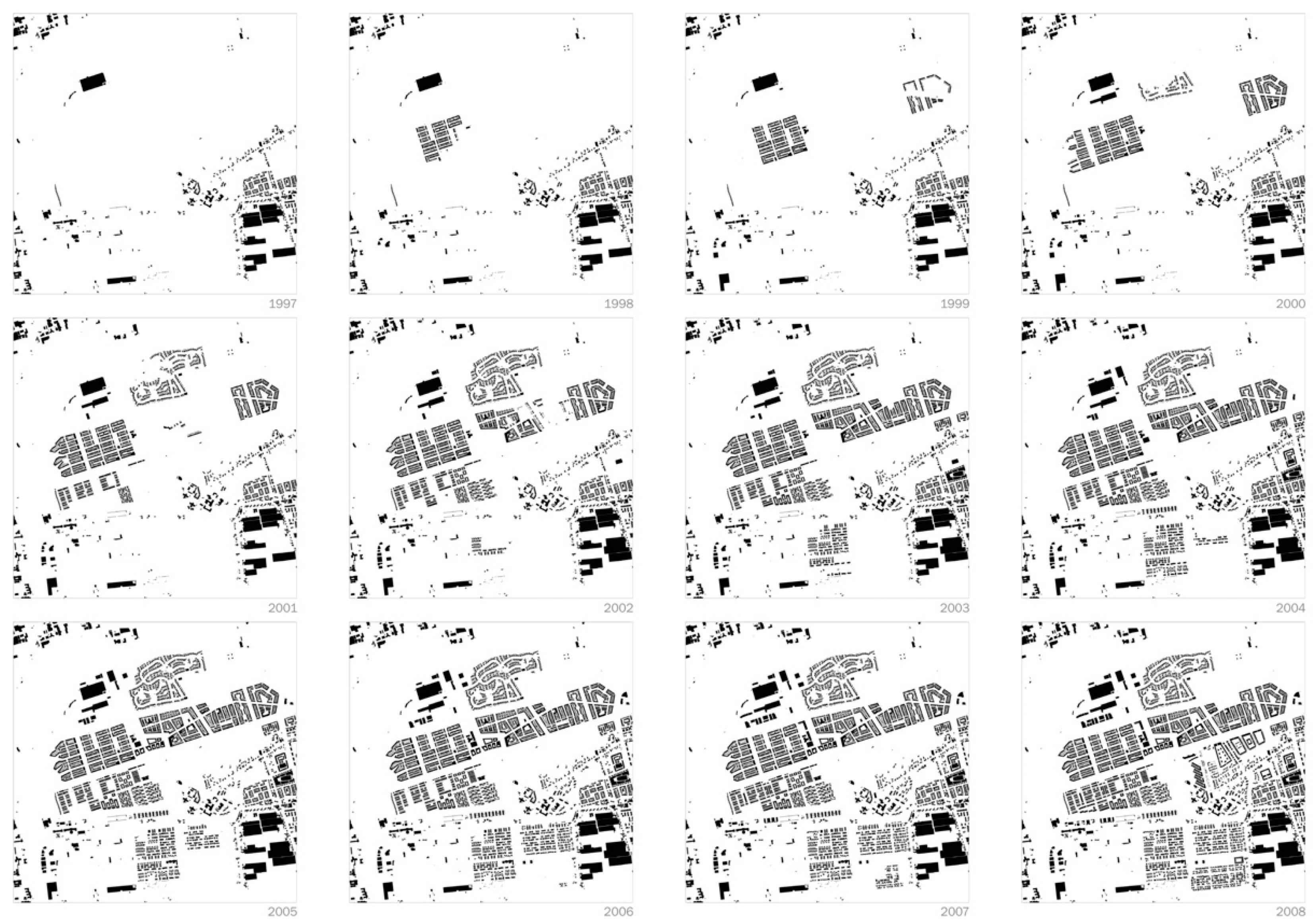
3.2. The Tussengebied as a Playground for Radical Concepts

The Tussengebied (area-in-between) in between Rotterdam, The Hague, and the new town of Zoetemeer expresses like nowhere else in The Netherlands, where the results of this segmented urbanization, in which the explosive post-war growth of urban and suburban areas, have led to a singular blurring of the distinction between the city and the countryside [12]: a peculiar territorial configuration where the urban borders are fading away, as expressed in Figure 2.
Starting from the eighties, the Tussengebied became the playground for many authors to express their radical visions and urban concepts fundamentally questioning the prevailing interpretations of the urban form coined in a dichotomy of “red” and “green” or “built” and “open” intrinsically related with the Randstad metaphor [55,56]. A series of initiatives began to explore the potential of design at a regional scale, embracing international discussions and spatial concepts. Organizations such as “Architecture in Rotterdam” (AIR), the “Eo Wijers Foundation”, or the ensemble of academics and professionals behind the “The Netherlands Now As Design” project (NNAO) aimed at visualizing ideas and framing problems [57] by defining appropriate fields of action [58] and novel approaches for planning policy [59].
Within this context, three authors interpreted the peculiar decentralized configuration of the Tussengebied, proposing different spatial concepts all highlighting a “new” metropolis in the size of an entire region and in the form of a field, but each with different specificities: Willem Jan Neutelings with the “patchwork metropolis” (1989), Frits Palmboom with the “urbanized landscape” (1987), and OMA—Floris Alkemade with the “field metropolis” (Deltametropool project, 2002) [60] (Figure 3).

3.3. Patchwork Metropolis

In 1989, the young “Enlightened prince of suburbia”—as Neutelings was called by the jury of the Maaskant Prize he won in 1991—was commissioned by the Department of Housing Development of the Municipality of The Hague to study and design the area of the Zuidrand (Southern Edge) between The Hague and Delft. Due to an agreement between the national and local governments, this area was selected for large-scale urbanization. The new urban district became nationally known as Ypenburg, named after a former regional airport located in the area [64].
Departing from this quintessential peripheral zone, Neutelings widened his focus, describing the area between The Hague and Rotterdam through the concept of the Patchwork Metropolis meant to highlight the conceptual simplification behind the common understanding of the urban condition: “the absurd notion of a romantic polarity between a paradisiacal Arcadia and a megalomaniac metropolis, a red stain sprawling in an endless expanse of green. […] has long been inadequate for interpreting the reality of the situation” [61]. The sketch that supported the work, a portion of which is included in Figure 3a, reconsidered the same area by means of a more critical reinterpretation. The territory is presented as a composition of patches, each one with a specific functional program and physical structure. In this system, not only is the “periphery”—the area usually labelled as such—a composition of patches, but the inner cities as well as the agricultural area are also an assembly of patches ranging from rural to industrial greenhouse complexes. The map presents a drastic novel interpretation of this part of the Dutch Randstad, in which the “juxtaposition of shifting fragments seems to define the structure’s single element of consistency” [65].
The patchwork metropolis was one of the first concepts to grasp the complex condition of the Dutch territory and to try to dismantle the prevailing doctrine based on the distinction between urban and rural. “If you look closer to the city, like a biologist, you would see that inside this red spot there are many green areas and inside the green a lot of red spots” [61]. The work by Neutelings challenges the traditional interpretations of the urban form by considering the territory, characterized by the presence of functions, activities and flows that, albeit with different intensity and different meanings, did not exclude any area from the metropolitan dynamics.

3.4. Urbanized Landscape

Unlike Neutelings’ imaginative and sketchy approach, Palmboom’s research on the “urbanized landscape” [62,66] tried to unravel the concealed logic of the territory between Rotterdam and The Hague with the aid of meticulous cartographic analysis. Starting from the history of the landscape and the way the territory has been modified through peat excavation, the creation of lakes and their reclamation, Palmboom was able to show the entire territory as constructed on the same common ground, also recognizing the past polder layout in the urban area.
In particular, the research on the Rotterdam urbanized landscape [66] shows that the spatial configuration of the landscape and the functional structure of the cities are usually consistent, leading to the superposition of new neighborhoods over the original spatial structure of the landscape. In his view, the urbanized landscape is then formed in a complex interplay between man and nature, where the development of cities is achieved through the articulation of the ground, which offers buildings a setting.
Palmboom’s analysis dissected the territory, separating it into three different layers. The first is the dynamic of the delta, expressed in the meandering course of rivers and harbors. The second includes the system of land division and the network of streets, and the third consists of infrastructural works: the ‘traffic machine’ that divides the city into islands and enclaves. All of these patterns overlap, producing continually alternating relationships without an unequivocal hierarchy. The city no longer assumes the form of a homogeneous architectonic entity, but that of a heterogeneous urbanized landscape [66].
The three-layer approach became one of the leading design methodologies of Frits Palmboom and Jaap van den Bout’s office, named Palmbout. The development plan for the Prinsenland (1987) and the Ypenburg Masterplan (1993) in the Zuidrand area are the first outcome of this approach.

3.5. Field Metropolis

The recognition of the fragmentary condition of the Randstad was the starting point for the development of the last spatial concept, the field metropolis. The lack of a center or “hollow core”—in contrast to familiar metropolitan regions such as London, Paris, and New York—represent for OMA the very Randstad identity worth stimulating. “Whilst the north is continuing to develop from the core city Amsterdam, as a classical concentric metropolis, the south occupies a far less coherent urban area. However, the south offers much potential. The question is how urban architectural intervention and administrative alteration in the economically stumbling South Wing (the South Wing is a Dutch province that includes Rotterdam and The Hague as its main urban centers) can produce a metropolis that will act as a single unit” [63].
By laying a rectilinear grid over the area in between The Hague and Rotterdam and designating it as a “city”, the OMA’s team created a logic for further development that is able to incorporate into a new ‘field, grid or pixel city’ not only the main cities of The Hague and Rotterdam, but also the minor villages, the parks, and the agricultural polder.
The field metropolis—visualized by OMA through a large backlit model composed of squared colored blocks—illustrates the potentiality of this enlarged territory to work exactly as a metropolis and to be designed as such: “The South Wing has plenty of opportunities for expansion; with the enormous port, the government center, Rotterdam airport, research and knowledge centers of world renown such as TNO, the University of Technology in Delft, and the Erasmus Medical Center. The area has a great deal to offer its residents. The number of theaters, museums and dance clubs is comparable to the Amsterdam region. The open spaces can still be developed into attractive natural areas. Based on targeted investment in, for example, the infrastructure, the South Wing could operate more effectively as a unit” [63].
Compared with the previously analyzed concepts, the grid represents for OMA what the soil formation was for Palmboom: a vast sea onto which all the different entities that populated this portion of territory are collected and identified. However, similarly to the patchwork proposal, at the basis of the field metropolis lies a fascination for the metropolitan congestion expressed by this area and for an uncoordinated juxtaposition able to reveal unusual connections.

4. Discussion: Toward a Novel View of the Tussengebied

The three spatial concepts, and consequently the three projects, showed common features in the conceptualization and design of the Tussengebied area, but also some specific characters from which to draw a general lesson for sustainable development and, in particular, for the definition of the urban–rural relationship.
To explore the capacity of the three works to clarify the urban–rural interrelation, this study used the categories presented by Davoudi: “knowing what”; “knowing how”; “knowing what end”; “doing”.

4.1. Knowing What

This category explores how the different projects interpret the definition of the boundary and establish the relationship between the urban and rural categories.
The three works presented the territory between The Hague and Rotterdam as a single “metropolis”, a shifting and unstable urbanized landscape in which traditional urban and peripheral qualities blend in an unusual manner. They shared a “shifted” interpretation of what has been lying hidden in the layout of the territory for a long time. Unlike the main Dutch planning policies, based on concepts such as city region (Third Memorandum on Spatial Planning, published in four parts from 1973 to 1983/1985), buffer zone, and compact city (Fourth Report on Spatial Planning, published in 1988), the three authors proposed a horizontal understanding of the area between Rotterdam and The Hague, highlighting some dynamics that were not recognizable by looking at the territory from the city point of view.
Despite these elements of continuity, the three spatial concepts highlight three different ways of understanding this margin area, proposing differentiated modes of establishing the boundary between urban and rural areas and therefore facing the topic of the sustainable development of the area.
Neutelings’ scheme interprets not only the urbanized territory but also agricultural and ecological areas as a system of patches with clear morphological values. Therefore, the articulation of the urban–rural relationship takes place along the boundaries of the patches and between the patches, and that portion of the agricultural open territory is characterized by segments that describe its territorial structure (Figure 4a (1–3)). The boundaries between what is urban and what is not are thus clearly demarcated by the pen strokes of the diagram that in a synthetic and interpretive form describe the urban morphology of the territory.
Although Palmboom’s drawing shows the entire territory of the Tussengebied area as built on the same common ground, recognizing the past arrangement of the polders even in the urban area (Figure 4b (2)), the use of colors intends to circumscribe what for him incontrovertibly represents the urban areas including historical strands and urban sprawl (Figure 4b (1,3)). Compared to the reductionist logic of Neutelings’ work, here, the description of the urban landscape, rendered in the drawing, is more in-depth and able to clarify in greater detail the typological characteristics of urban areas and the spatial qualities of open territories.
In contrast, the urban–rural distinction in the OMA scheme appears more succinct. Within the backlit matrix that entirely covers the territory sprawl (Figure 4c (1)), a few urban figures have emerged in which morphological characters are recognizable (Figure 4c (3)). In this case, the scheme does not consider the urban filaments that connect the historic centers of this portion of The Netherlands, nor the small towns and urban sprawl. Everything is here reduced within the geometric matrix that describes the open territory through a mosaic composed of different colors and textures, capable of expressing the functions and consistency of the various tesserae, but not the spatial qualities of the territory.

4.2. Knowing How

This category examines what tools urbanists use to establish, interpret, and design the relationship between urban and rural. The comparative analysis of the three diagrams summarizing the work shows how the three authors conceived the morphological configuration of the built-up area, the open areas (natural and agricultural), and the infrastructural elements of mobility differently.
The Neutelings’ diagram is characterized by a reduction in the elements to those strictly related to the scale of the patches excluding the component of mobility and connections (Figure 4a (4)). The patches were articulated according to their morphology and differentiated by a characteristic pattern. They include the urban environments differentiated according to their different periods of construction and morphological configuration (historical centers, historical filaments, functionalist neighborhoods built in the first half of the 20th century, and cauliflower quarters built between the 1960s and 1980s; Figure 4a (3)). Patches also include some productive and agricultural areas (greenhouses, service, and commercial areas) as well as some specific parks and ecological areas (Figure 4a (2)).
Palmboom’s analysis dissects the territory, separating it into three different layers. The first represents the dynamic of the delta, expressed in the meandering course of rivers and harbors. The second includes the system of land division and the network of streets, and the third consists of infrastructural works: the ‘traffic machine’ that divides the city into islands and enclaves. All of these patterns overlap, producing continually alternating relationships without an unequivocal hierarchy (Figure 4b (1–4)).
The field metropolis is visualized by OMA through a large backlit model composed of squared colored blocks that summarize the underlying continuous structure of the territory. This matrix contains within it specific urban (historic city centers), environmental (rivers and canals and major parks), and infrastructural (railway and motorway lines and airports) figures. In this diagram, empty space is absent, and everything is summarized through a system of seamlessly juxtaposed volumes (Figure 4c (1)).

4.3. Knowing What End

This category investigates the design purposes for which a spatial concept and a specific strategy are chosen.
The three works share the same critique of the canonical understanding of the urban–rural relationship. After many decades of decentralization policies [52] aiming at building a polycentric region, the urban centers are touching each other, producing a strange configuration in which it is impossible to distinguish what is red from what is green, corrupting the happy figure of coordinated cities immersed in an Arcadian landscape. Instead of trying to fight against Randstad’s lack of coherence, the three urbanists accept edits actual condition. This shared attitude paved the way for novel prospective projects far more in tune with socio-spatial trends.
The three approaches presented in this essay depict three ways to raise this critique:
Neutelings began the text by stating “the absurd notion of a romantic polarity between a paradisiacal Arcadia and a megalomaniac metropolis, a red stain sprawling in an endless expanse of green. […] has long been inadequate for interpreting the reality of the situation” [61], underlying that the juxtaposition of shifting fragments seems to define the structure’s single element of consistency [64]. The metropolitan congestion of fragments is what Neutelings describes in a twenty-minute drive through the Randstad in which the traveler is taken through “sculptural oil refineries, colorful bulb-fields, intimate garden cities, medieval rings of canals, eight-lane motorways, hypermarkets, functional high-rise estates, lakes for recreation, old Dutch windmills, university campuses, tourist beaches, protected dune landscapes, glass roofs of greenhouses, reflecting business parks, motel for furniture mega-stores, rubbish tips and golf courts, airfields, market, squares and mosques” [61].
Palmboom shows in his drawings that the spatial configuration of the landscape and the functional structure of the cities are usually consistent, leading to the superposition of new neighborhoods over the original spatial structure of the landscape. This revelation was a real breakthrough because it was able to counterbalance the myth of Rotterdam as a pristine showcase of modernism, revealing the pre-existence of the Dutch polder layout in the neighborhood’s pattern.
The recognition of the fragmentary condition of the Randstad was also the starting point for the development of the field metropolis concept. The lack of a center or ‘hollow core’—in contrast to familiar metropolitan regions such as London, Paris and New York—represents for OMA the very Randstad identity worth stimulating. “Whilst the north is continuing to develop from the core city Amsterdam, as a classical concentric metropolis, the south occupies a far less coherent urban area. However, the south offers much potential. The question is how urban architectural intervention and administrative alteration in the economically stumbling South Wing (the South Wing is the Dutch province that includes Rotterdam and The Hague as its main urban centers) can produce a metropolis that will act as a single unit” [63].
Although there exists more than a decade between the first two projects and the third, a decade that was fundamental in urban planning for raising awareness toward the issue of sustainable development, this distance is not perceivable in the definition of the projects and their design goals. Instead, a greater continuity of intent exists between the Oma and Neutelings projects than in the approach deployed in Palmboom’s work. If in fact Neutelings and Oma developed a careful morpho-typological reading aiming toward economic valorization of the territory, Palmboom focused on the definition of its deep structure to assess the ecological-landscape compatibility of its transformation.

4.4. Doing

This category explores the operational results of the three different projects, clarifying how spatial concepts can help to manage the urban–rural relationship and what physical repercussions they could have on the territory.
The concept of the patchwork metropolis is also the leading principle of the Neutelings’ design proposal for Zuidrand. The mode of management of the urban–rural relationship implied in the patchwork’s logic involves the transformation, the fragmentation of existing patches, or the addition of new patches to the system. Through the compilation of a catalogue of new patches, Neutelings clarified the scale and the conditions of the future development of the area: new commercial boulevards displaced along a motorway, socio-bungalows with a wide range of accessories, a linear park crowned by duplexes and roof garden dwellings, a square for events arranged below a motorway spaghetti node, dwellings for retirees positioned close to a golf course; these all represent the vocabulary of new patches that are carefully inserted in the existing patchwork according to the parameters of proximity and accessibility.
Unlike the Neutelings project, which resulted in the design of brand-new patches, the Palmbout plan for Ypenburg deals with the design of public open space and the major networks, leaving the task of filling in the landscape to the unpredictable joint effort of government and commercial interests. This sophisticated device—based on the careful analysis of the transformation process of the landscape—allowed Palmbout to propose a design solution in the form of a land preparation process, producing a robust spatial structure that asserts its authority apart from programmatic uncertainties, remaining meaningful over the long-term [67]. The urban–rural relationship in this way becomes less peremptory by providing numerous nuances of light urbanization considered as compatible with an open land context, anticipating the research of other Dutch landscape architects and urbanists such as the work by Dirk Sijmon in the casco-concept [68] or the work of Adriaan Geuze for the Alexanderpolder [69].
The most significant design proposal offered by OMA is, instead, the conversion of the A13 motorway into a central urban boulevard that, acting like the Champs-Elysses of Paris or the Avenida Diagonal of Barcelona, would create enormous opportunity for future development, fixing the coherence of the field metropolis as a whole. A ride through a motorway is also the same as what Neutelings called revealing the internal functional logic of this territory. There is not a metropolis without a metropolitan experience and by driving on the highway, it is possible to find a “City à la carte”, which for both Neutelings and the OMA team is much more exciting than people have ever thought [60,64]. The new infrastructural system proposed by OMA opens new possibilities for linear urbanization linking the major centers of the South Wing province, which, by exploiting the new potential accessibility, can take place through a reversal of the colored mosaic tiles.

4.5. Ypenburg District

The area of the Tussengebied became one of the contexts for a new urban district developed according to the 1991 Spatial Planning Report, the Fourth Report Extra [52,53]. The essence of this report was the planning of new urban districts, named Vinex, planned close to the main dense centers—in fact at their edge—usually located in brownfield sites within the city perimeters. This policy was meant to strengthen the position and the economy of the main cities and was developed in the form of new districts spatially isolated but well-connected to the highway network. The Vinex policy produced more than 800.000 new dwellings over a decade, tremendously strengthening the fragmented structure of the Randstad.
Sited where Ypenburg airfield used to be, south of The Hague at the core of Tuissengebied, this Vinex district lies wedged between motorways and railway tracks. Ypenburg’s masterplan (1994) defines an expansion area for approximately 11,000 residential units (Figure 5) on two levels: the first concerns the design of the infrastructure network and public spaces, which was taken care of by Palmboom and van den Bout; the second concerns the design of the residential and commercial areas [70].
The masterplan condenses most of the insights developed in the three analyzed projects and seeks to assimilate the landscape characteristics on site, following the Palmboom approach in the urbanized landscape research. Thus, for example, the former runway is now a broad central boulevard. Five ‘fields’—Singels, Boswijk, Venen, Waterwijk, and De Bras—cluster around the district’s center. Each field, like the Neutelings patches, has its own ambience: Waterwijk features projects by Claus & Kaan, Bosch Haslett, and MVRDV. In one sub-area of Singels, West 8 has supervised an ‘organized chaos’ of dwelling types.
Located along the A13, the new district reinforces the central role of the motorway as the backbone of this area, although it does not contemplate its transformation into a boulevard, as envisaged in the OMA proposal.

5. Conclusions

Through the analysis of the case study of the Tussengebiet in The Netherlands and its reinterpretation developed by three eminent urbanists, the article investigated how spatial concepts can govern the urban–rural relationship by proposing a precise form of territory that presupposes the rules, modes of operation, and instruments of transformation.
Through the application of a methodology based on learning-from-expert-knowledge, the article analyzed three spatial concepts developed in the work of Willem Jan Neutelings (patchwork metropolis, 1989), Frits Palmboom (urbanized landscape, 1990), and the Office for Metropolitan Architecture (field metropolis, 2002).
To explore the capacity of their work to clarify the urban–rural interrelation, this study used the categories presented by Davoudi [44], and adapted them as follows: “knowing what” explores how different urbanists interpret the definition of the boundary between urban and rural and establish the relationship between these two categories; “knowing how” examines what tools urbanists use to establish, interpret, and design this relationship; “knowing what end” investigates the design purposes for which a spatial concept and a specific strategy are chosen; “doing” explores the operational results of the three different projects, clarifying what physical repercussions they could have on the territory.
The three works showed several elements of continuity such as the same critique to the canonical understanding of the urban–rural relationship connected with a similar conceptualization of the territory between The Hague and Rotterdam as a single “metropolis”, an urbanized landscape in which traditional urban and peripheral qualities blend together in an unusual manner. The three spatial concepts instead proposed differentiated modes of operation that led the urbanists to three different projects with different physical repercussions on the territory. In this sense, the use of spatial concepts in these projects serves to clarify both the cognitive and interpretative tools (“knowing how”) deployed by the various urbanists, but the detailed operational choices even more so (what Davoudi called “doing” [44]).
The masterplan for the area of Ypenburg, designed by Palmboom and van den Bout at the core of Tuissengebied, condenses most of the insights developed in the three analyzed projects: it seeks to assimilate the landscape characteristics on site as in the Palmboom urbanized landscape research, develop several differentiated urban districts, each with its own ambience, like in the Neutelings patchwork metropolis, and reinforce the central role of the A13 motorway as in the OMA field metropolis.
According to Secchi [71], the literature on contemporary cities is immense, but perhaps the technically relevant descriptions are not as numerous as commonly believed. The contemporary city seems, in fact, to offer fierce resistance to its description, and even more to these projects. For these reasons, the use of spatial concepts such as the patchwork and field metropolis or the urbanized landscape is noteworthy, for their ability to foster a debate on the contemporary city and the ways of designing its boundaries, a debate that is able to articulate in design terms the conceptual schemes between urban and rural areas advanced from the Second National Policy Document (1966).

Funding

This research was funded by European Union and Sardinian Region grant [Master and Back P.O.R. FSE 2007-2013-IV Axis-Human Capital-Activity i.3.1].

Institutional Review Board Statement

Not applicable.

Informed Consent Statement

Not applicable.

Data Availability Statement

Not applicable.

Conflicts of Interest

The author declares no conflict of interest.

References

  1. Breheny, M.J. The Renaissance of Strategic Planning? Environ. Plan. B Plan. Des. 1991, 18, 233–249. [Google Scholar] [CrossRef]
  2. Sieverts, T. Cities without Cities: An Interpretation of the Zwischenstadt, 1st ed.; Routledge: London, UK, 2003; ISBN 978-0-415-27260-5. [Google Scholar]
  3. Albrechts, L. Planners as Catalysts and Initiators of Change. The New Structure Plan for Flanders. Eur. Plan. Stud. 1999, 7, 587–603. [Google Scholar] [CrossRef]
  4. Albrechts, L.; Healey, P.; Kunzmann, K.R. Strategic Spatial Planning and Regional Governance in Europe. J. Am. Plan. Assoc. 2003, 69, 113–129. [Google Scholar] [CrossRef]
  5. Healey, P. Collaborative Planning: Shaping Places in Fragmented Societies; Macmillan: London, UK, 1997; ISBN 978-0-333-49574-2. [Google Scholar]
  6. Gaeta, L.; Janin Rivolin, U.; Mazza, L. Governo del Territorio e Pianificazione Spaziale; CittàStudi: Turin, Italy, 2013; ISBN 978-88-2517-382-6. [Google Scholar]
  7. Zimmermann, K.; Galland, D.; Harrison, J. (Eds.) Metropolitan Regions, Planning and Governance; Springer International Publishing: Cham, Switzerland, 2020; ISBN 978-3-030-25631-9. [Google Scholar]
  8. Balducci, A.; Curci, F.; Fedeli, V. Una galleria di ritratti dell’Italia post-metropolitana. Territorio 2016, 20–22. [Google Scholar] [CrossRef]
  9. Barile, A.; Raffini, L.; Alteri, L. Il Tramonto Della Città. La Metropoli Globale tra Nuovi Modelli Produttivi e Crisi Della Cittadinanza; DeriveApprodi: Roma, Italy, 2019; ISBN 978-88-6548-296-4. [Google Scholar]
  10. Corsi, S.; Sali, G.; Monaco, F.; Mazzocchi, C. The Cores of Metropolitan Areas: Evidence from Five European Contexts. TERRITORIO 2015, 182–188. [Google Scholar] [CrossRef]
  11. Brenner, N.; Pullano, T. Stato, Spazio, Urbanizzazione; Guerini Scientifica: Milan, Italy, 2016; ISBN 978-88-8107-404-4. [Google Scholar]
  12. Pisano, C. The Patchwork Metropolis: Between Patches, Fragments and Situations. In The Horizontal Metropolis Between Urbanism and Urbanization; Viganò, P., Cavalieri, C., Barcelloni Corte, M., Eds.; Springer International Publishing: Cham, Switzerland, 2018; pp. 93–100. ISBN 978-3-319-75975-3. [Google Scholar]
  13. Dijkstra, L.; Poelman, H. Regional Typologies: A Compilation; European Union Regional Policy; European Union: Milan, Italy, 2011. [Google Scholar]
  14. The State of European Cities Report—European Environment Agency. Available online: https://www.eea.europa.eu/themes/sustainability-transitions/urban-environment/links/data-and-information/the-state-of-european-cities-report (accessed on 15 February 2023).
  15. Soja, E.W. Postmodern Geographies: The Reassertion of Space in Critical Social Theory; Verso Books: London, UK, 2010; p. 228. ISBN 978-1-84467-669-9. [Google Scholar]
  16. Secchi, B.; Viganò, P. La ville Poreuse. Un Projet Pour le Grand Paris et la Métropole de L’après-Kyoto, 1st ed.; METISPRESSES: Geneva, Switzerland, 2011; ISBN 978-2-940406-56-2. [Google Scholar]
  17. Allen, S. Points and Lines: Diagrams and Projects for the City; Princeton Architectural Press: New York, NY, USA, 1999; ISBN 978-1-56898-155-0. [Google Scholar]
  18. Pisano, C.; Saddi, V. Open and Closed Figures in Dutch Spatial Planning. In Shaping Regional Futures: Designing and Visioning in Governance Rescaling; Lingua, V., Balz, V., Eds.; Springer International Publishing: Cham, Switzerland, 2020; pp. 173–181. ISBN 978-3-030-23573-4. [Google Scholar]
  19. Meijsmans, N.; de Zwart, B. Towards a Culture of Regional Design. OASE-Territ 2009, 80, 108–125. [Google Scholar]
  20. Healey, P. The Treatment of Space and Place in the New Strategic Spatial Planning in Europe. Int. J. Urban Reg. Res. 2004, 28, 45–67. [Google Scholar] [CrossRef]
  21. Vettoretto, L.; Indovina, F. La Città Diffusa; DAEST—IUAV: Venice, Italy, 1990. [Google Scholar]
  22. Hertweck, F.; Marot, S. The City in the City. Berlin: A Green Archipelago; Lars Mueller Publishers: Zurich, Switzerland, 2013; ISBN 978-3-03778-326-9. [Google Scholar]
  23. Viganò, P.; Cavalieri, C.; Barcelloni Corte, M. (Eds.) The Horizontal Metropolis Between Urbanism and Urbanization; Springer International Publishing: Cham, Switzerland, 2018; ISBN 978-3-319-75974-6. [Google Scholar]
  24. Indovina, F. Dalla Città Diffusa All’arcipelago Metropolitano; Franco Angeli: Milan, Italy, 2009; ISBN 978-88-568-1170-4. [Google Scholar]
  25. Baumgartner, F.R.; Jones, B.D. Agendas and Instability in American Politics, 2nd ed.; Chicago Studies in American Politics; University of Chicago Press: Chicago, IL, USA, 2009; ISBN 978-0-226-03949-7. [Google Scholar]
  26. van Duinen, L. New Spatial Concepts Between Innovation and Lock-in: The Case of the Dutch Deltametropolis. Plan. Pract. Res. 2015, 30, 548–569. [Google Scholar] [CrossRef]
  27. Stone, D. Policy Paradox: The Art of Political Decision Making; Revised ed.; W. W. Norton & Company: New York, NY, USA, 2001; ISBN 978-0-393-97625-0. [Google Scholar]
  28. Campbell, J.L. Institutional Analysis and the Role of Ideas in Political Economy. Theory Soc. 1998, 27, 377–409. [Google Scholar] [CrossRef]
  29. Campbell, J.L. Ideas, Politics, and Public Policy. Annu. Rev. Sociol. 2002, 28, 21–38. [Google Scholar] [CrossRef]
  30. Hajer, M.A. Setting the Stage: A Dramaturgy of Policy Deliberation. Adm. Soc. 2005, 36, 624–647. [Google Scholar] [CrossRef]
  31. Rein, M.; Laws, D. Controversy, Reframing and Reflection. In The Revival of Strategic Spatial Planning; Salet, W.G.M., Faludi, A., Eds.; KNAW: Amsterdam, The Netherlands, 2000. [Google Scholar]
  32. Dematteis, G. Progetto Implicito. Il Contributo Della Geografia Umana Alle Scienze del Territorio, 2nd ed.; Franco Angeli: Milano, Italy, 2002; ISBN 978-88-204-9830-6. [Google Scholar]
  33. Pisano, C. L’uso di Spatial Concept nel progetto d’area vasta. Tre genealogie a confronto. CRIOS 2019, 18, 21–36. [Google Scholar] [CrossRef]
  34. Secchi, B. Isotropy vs Hierarchy. In Landscape of Urbanism; Ferrario, V., Sampieri, A., Viganò, P., Eds.; Officina Edizioni: Venezia, Italy, 2011. [Google Scholar]
  35. Viganò, P.; Secchi, B.; Fabian, L. Water and Asphalt: The Project of Isotropy/Editors: Paola Viganò, Bernardo Secchi, Lorenzo Fabian; UFO (Amsterdam, Netherlands); Park Books: Zürich, Switzerland, 2016; ISBN 978-3-906027-71-5. [Google Scholar]
  36. Guida, G. Immaginare Città. Metafore e Immagini per la Dispersione Insediativa, 1st ed.; Franco Angeli: Milano, Italy, 2011; ISBN 978-88-568-3536-6. [Google Scholar]
  37. Hall, P. The World Cities; McGraw-Hill: New York, NY, USA, 1971; ISBN 978-0-07-025600-2. [Google Scholar]
  38. van Assche, K.; Beunen, R.; Verweij, S. Comparative Planning Research, Learning, and Governance: The Benefits and Limitations of Learning Policy by Comparison. Urban Plan. 2020, 5, 11–21. [Google Scholar] [CrossRef]
  39. Dunlop, C.A.; Radaelli, C.M. Systematising Policy Learning: From Monolith to Dimensions. Polit. Stud. 2013, 61, 599–619. [Google Scholar] [CrossRef]
  40. Spicer, A.; Alvesson, M.; Kärreman, D. Critical Performativity: The Unfinished Business of Critical Management Studies. Hum. Relat. 2009, 62, 537–560. [Google Scholar] [CrossRef]
  41. Kendall, M.; Gibbons, J.D. Rank Correlation Methods, 5th ed.; Oxford Univ Pr: London, UK; New York, NY, USA, 1990; ISBN 978-0-19-520837-5. [Google Scholar]
  42. Bogner, A.; Littig, B.; Menz, W. (Eds.) Interviewing Experts, 2009th ed.; Palgrave Macmillan: Basingstoke, UK; New York, NY, USA, 2009; ISBN 978-0-230-22019-5. [Google Scholar]
  43. Iriste, S.; Katane, I. Expertise as a Research Method in Education. Rural Environ. Educ. Personal. 2018, 11, 74–80. [Google Scholar]
  44. Davoudi, S. Planning as Practice of Knowing. Plan. Theory 2015, 14, 316–331. [Google Scholar] [CrossRef]
  45. Freeman, R. Epistemological Bricolage: How Practitioners Make Sense of Learning. Adm. Soc. 2007, 39, 476–496. [Google Scholar] [CrossRef]
  46. Schon, D. The Reflective Practitioner: How Professionals Think in Action; Basic Books: New York, NY, USA, 1984; ISBN 978-0-465-06878-4. [Google Scholar]
  47. Alvesson, M.; Lee Ashcraft, K.; Thomas, R. Identity Matters: Reflections on the Construction of Identity Scholarship in Organization Studies. Organization 2008, 15, 5–28. [Google Scholar] [CrossRef]
  48. Hering, J.G. Do We Need “More Research” or Better Implementation through Knowledge Brokering? Sustain. Sci. 2016, 11, 363–369. [Google Scholar] [CrossRef]
  49. Blackler, F. Knowledge, Knowledge Work and Organizations: An Overview and Interpretation. Organ. Stud. 1995, 16, 1021–1046. [Google Scholar] [CrossRef]
  50. Pisano, C. Patchwork Metropolis. Un Modello Teorico per Il Progetto Dei Territori Contemporanei. Ph.D. Thesis, Università degli Studi di Cagliari, Cagliari, Italy, 2014. [Google Scholar]
  51. Pellenbart, P.H.; Van Steen, P.J.M. Making Space, Sharing Space: The New Memorandum on Spatial Planning in the Netherlands. Tijdschr. Voor Econ. En Soc. Geogr. 2001, 92, 503–512. [Google Scholar] [CrossRef]
  52. Alexander Wandl, D.I.; Nadin, V.; Zonneveld, W.; Rooij, R. Beyond Urban–Rural Classifications: Characterising and Mapping Territories-in-between across Europe. Landsc. Urban Plan. 2014, 130, 50–63. [Google Scholar] [CrossRef]
  53. van der Cammen, H.; de Klerk, L.A.; Dekker, G.; Witsen, P.P. The Selfmade Land: Culture and Evolution of Urban and Regional Planning in the Netherlands; Unieboek|Het Spectrum: Amsterdam, The Netherlands, 2012; ISBN 978-90-491-0701-7. [Google Scholar]
  54. Needham, B.; Dekker, A. The Fourth Report on Physical Planning in the Netherlands. Neth. J. Hous. Environ. Res. 1988, 3, 335–344. [Google Scholar] [CrossRef]
  55. Burke, G.L. Greenheart Metropolis: Planning the Western Netherlands; Palgrave: Macmillan/London, UK, 1966; ISBN 978-1-349-81773-3. [Google Scholar]
  56. Lambregts, B.; Zonneveld, W. From Randstad to Deltametropolis: Changing Attitudes towards the Scattered Metropolis. Eur. Plan. Stud. 2004, 12, 299–321. [Google Scholar] [CrossRef]
  57. Sutton, S.E.; Kemp, S.P. Integrating Social Science and Design Inquiry through Interdisciplinary Design Charrettes: An Approach to Participatory Community Problem Solving. Am. J. Community Psychol. 2006, 38, 125–139. [Google Scholar] [CrossRef]
  58. Balz, V.; Zonneveld, W. Regional Design in the Context of Fragmented Territorial Governance: South Wing Studio. Eur. Plan. Stud. 2014, 23, 1–21. [Google Scholar] [CrossRef]
  59. van Dijk, T. Imagining Future Places: How Designs Co-Constitute What Is, and Thus Influence What Will Be. Plan. Theory 2011, 10, 124–143. [Google Scholar] [CrossRef]
  60. Pisano, C. The Segmented Metropolis. The Tussengebied According to Neutelings, Palmboom and Alkemade. MONU 2017, 26, 52–57. [Google Scholar]
  61. Neutelings, W.J. Willem Jan Neutelings, Architect; Uitgeverij 010: Rotterdam, The Netherlands, 1991; ISBN 978-90-6450-120-3. [Google Scholar]
  62. Palmboom, F. Landschap en Verstedelijking Tussen Den Haag en Rotterdam; Stadsontwikkeling Gemeente: Rotterdam, The Netherlands, 1990; ISBN 978-90-72979-02-5. [Google Scholar]
  63. Delta Metropool. Available online: https://www.oma.com/projects/delta-metropool (accessed on 21 February 2023).
  64. Pisano, C. Patchwork Metropolis. Progetto di Città Contemporanea; Lettera Ventidue edizioni: Siracusa, Italy, 2018. [Google Scholar]
  65. Beelen, K. Imag(En)Ing the Real. The ‘Region’ as a Project of Cartographic Re-Configuration. In Designing for a Region; Uitgeverij SUN: Amsterdam, The Netherlands, 2010. [Google Scholar]
  66. Palmboom, F. Rotterdam, Verstedelijkt Landschap. OASE 1987, 17, 60–64. [Google Scholar]
  67. Palmboom, F. Drawing the Ground Landscape Urbanism Today; Birkhuser Architecture: Basel, Switzerland, 2010. [Google Scholar]
  68. Dirk, S. Het Casco-Concept: Een Benaderingswijze Voor Landschapsplanning; NBLF: Utrecht, The Netherlands, 1991. [Google Scholar]
  69. Devolder, A.-M. Alexanderpolder: New Urban Frontiers; Laterza: Thoth, Egypt, 1993; ISBN 978-90-6868-074-4. [Google Scholar]
  70. Betsky, A. The New Land: The work of palmbout urban landscapes. In The New Land: The Work of Palmbout Urban Landscapes; Birkhäuser: Basel, Switzerland, 2012; pp. 29–32. ISBN 978-3-0346-1207-4. [Google Scholar]
  71. Secchi, B. Prima Lezione di Urbanistica, 15th ed.; Laterza Editore: Bari, Italy, 2000; ISBN 978-88-420-6060-4. [Google Scholar]
Figure 1. Conceptual sketches of the evolution of Dutch territory according to the Second National Policy Document (1966), the three national urbanization patterns. Black lines represent roads; dashed lines represent railways; pink backgrounds represent urbanised areas. From left: urban concentration (a), radical de-concentration (b), and the preferred solution: the concentrated de-concentration (c) [53].
Sustainability 15 06958 g001
Figure 2. Built-up plan of the area between Rotterdam and The Hague. In red buildings after 1991; the square indicates the core area where the dissolution between urban and rural is more evident [50] (author’s own, 2014).
Sustainability 15 06958 g002
Figure 3. Diagrams of the three works: (a) patchwork metropolis [61]; (b) urbanized landscape [62]; (c) field metropolis [63] (author’s own, 2017).
Sustainability 15 06958 g003
Figure 4. Analytical deconstruction of the three works: (a) patchwork metropolis; (b) urbanized landscape; (c) field metropolis. (1) Original picture; (2) unbuilt (natural and agricultural land); (3) urban; (4) infrastructures (author’s own, 2017).
Sustainability 15 06958 g004
Figure 5. Evolution of the building fabric in the Ypenbug area [50] (author’s own, 2014).
Sustainability 15 06958 g005
Table 1. The three works under study.
ExpertYearSpatial ConceptCommission
Willem Jan Neutelings1989Patchwork
Metropolis
Commissioned by the Department of Housing Development of the Municipality of The Hague to study and design the area of the Zuidrand (Southern Edge) between The Hague and Delft
Palmbout—Frits
Pamboom
1990Urbanized
Landscape
Developed as a theoretical study and then applied in the development plan for the Prinsenland (1987), a Rotterdam expansion area, and the Ypenburg masterplan (1993) in the Zuidrand (Southern Edge) between The Hague and Delft
Office for Metropolitan Architecture—Floris Alkemade2002Field
Metropolis
A competition launched by the Dutch Rijksbouwmeester that followed the research of the Deltametropool Foundation, coordinated by Dirk Frieling, launched to study Randstad as a unique Metropolitan Region of 2800 km2 and almost 7 million inhabitants
Disclaimer/Publisher’s Note: The statements, opinions and data contained in all publications are solely those of the individual author(s) and contributor(s) and not of MDPI and/or the editor(s). MDPI and/or the editor(s) disclaim responsibility for any injury to people or property resulting from any ideas, methods, instructions or products referred to in the content.

