Abstract
The South Slope District of the Mahu Depression in the Junggar Basin, a major favorable zone for middle and superficial oil–gas exploration, has experienced industrial gas flow. However, research on the sedimentary microfacies characteristics of Segment 2 of the Sangonghe Formation, the main oil-bearing formation, remains lacking. In this study, the rock type, sedimentary tectonics, and sedimentary microfacies of Segment 2 of the Jurassic Sangonghe Formation in the South Slope District of the Mahu Depression were thoroughly investigated through 3D seismic, rock core, and logging data. Moreover, the sedimentary modes and distribution characteristics of the sand bodies in the study area were further analyzed. Results showed that subfacies at the front edge of the braided river delta are developed at Segment 2 of the Sangonghe Formation, which can be further divided into four microfacies types, namely, underwater distributary channel, sheet sand, estuary dam, and interdistributary bay. The estuary dam is only developed at local positions in the work area. The vertical evolutionary laws from Segment 2 of the Sangonghe Formation to Segment 3 of the Sangonghe Formation are explicit and manifest as retrogradation from the subfacies at the front edge of the braided river delta to the prodelta. The sand bodies formed by frequent swings of the underwater distributary channels are the main reservoir bodies, and the lithology is mainly fine-grained feldspar lithic sandstone, and sedimentary tectonics have diverse forms. On the basis of deposition microphase analysis, the sand bodies’ planar distribution characteristics under phase-controlled conditions were analyzed using a seismic model inversion technology to provide theoretical guidance for oilfield expansion, exploration, and exploitation.
1. Introduction
The term braided river delta was first proposed by MCPherson [1], which is a sand- and gravel-rich deltaic deposit formed by the braided river system pre-deposited into stagnant water bodies, and its depositional conditions and sedimentary characteristics are between those of coarse clastic fan deltas and fine-grained curvilinear river deltas, with better reservoir performance and hydrocarbon-bearing properties than fan deltas. Scholars at home and abroad have gradually formed a mature theoretical system through years of research. The braided river delta is a coarse-grained delta rich in sand and gravel formed by a single bottom-loaded river feeding into a stable water body. On the plain, the braided river delta is mainly composed of two sedimentary subphases, braided plain and braided delta front, and can be subdivided into several microphases. Compared with the braided river delta, it is characterized by higher topographic elevation and coarser deposition of clastic material, which is usually higher than the normal coarse clastic fraction of the braided river delta. Compared to fan deltas, which have relatively small topographic elevation differences and relatively finer clastic material, braided river deltas have more pronounced divergent channelization at their leading edges [2,3]. In addition, two types of sedimentation patterns are proposed, namely, the dendritic to finger-like evolution of the receding delta and the contiguous distribution of sand bodies in the advancing delta [4,5,6]. At present, there are abundant research results on Jurassic sedimentary features in Junggar Basin. Yubo Qiu, Wang Hui, and Zhengke Qiu, among others, believe that the sedimentary phase type of the Sangonghe Formation is the braided river delta phase, in which the plains and foreland subphase sands are the main reservoirs of hydrocarbons [7,8], and oil-bearing sands are found in the Permian and Triassic strata in Junggar Basin with considerable distribution scale; however, most of them are fan deltas and braided river delta plains. However, most of them are coarse-grained sand and conglomerate reservoirs deposited in the fan delta and braided river delta plains, while the Jurassic Sangonghe Formation Section II oil formation is a sandstone reservoir developed in the northwest margin of the Junggar Basin and distributed in the middle and shallow layers. The study of sedimentary micro-phase and sand body spreading in the study area aims to analyze the spatial spreading pattern of oil-bearing clearly.
Junggar Basin is a typical superimposed petroliferous basin in Western China. The Mahu Depression is an important depression rich in hydrocarbons in the center of the Junggar Basin. With the continuous advancement of oil–gas exploration in the northwest edge of the Junggar Basin toward the depression center in recent years, a billion tons of large-scale glutenite oil and gas reservoirs have been found in the Permian and Triassic strata [9,10,11,12]. Moreover, industrial oil and gas flows were discovered in superficial Jurassic and Cretaceous sandstones and conglomerates in the slope district of the Mahu Depression. This phenomenon is attributed to the sedimentation of three sets of significantly thick hydrocarbon source rocks in the Mahu Depression: Lower Permian Jiamuhe Formation, Fengcheng Formation, and Middle Permian Lower Urho Formation. The hydrocarbon rocks are mostly developed in the Fengcheng Formation [13,14], followed by the vertical oil–gas migration channel formed by faults at different levels and good positions with lateral shielding in the northwest edge of the basin [15,16]. The Permian and Triassic strata were previously extensively discussed. In previous studies, research areas were concentrated in the Kebai–Wuxia fault zone. At present, only a few studies have been conducted on the superficial strata in the Mahu Depression [17]. In 2016, an industrial oil flow was discovered in the middle and superficial glutenites during old well re-examination. Exploration and exploitation of superficial oil and gas in the Mahu Depression have been a research hotspot since then [18]. The middle and superficial oil and gas reservoirs also replaced a hundred miles of oil zone on the northwest edge. A large-scale distribution of sand bodies in underwater distributary channels was found at the front edges of the braided river delta of the Lower Jurassic Sangonghe Formation in the South Slope District of the Mahu Depression. Moreover, the burial depth is low, and the reservoir strata have good properties. This field is important for lithology, oil, and gas reservoir exploration [19,20]. Sand Group 4 at Segment 2 of the Sangonghe Formation is a main oil-producing segment in the study area where the sand body is 5–20 m thick. The evident characteristics are thin layers and high yields.
However, as the reservoir has not been in development for long, few studies have been conducted on sedimentary microfacies types and distribution characteristics of sand bodies in the middle and superficial strata in the study area. Given that sand bodies of underwater distributary channels quickly change along the horizontal direction, the spatial distribution of sedimentary facies and single sand bodies must be carefully depicted. In this study, Sand Group 4 at Segment 2 of the Sangonghe Formation in Well Zone A on the South Slope of the Mahu Depression in the Junggar Basin was chosen as the research object. The target strata’s well-logging facies were analyzed by combining rock core, logging, and seismic data. Moreover, the sedimentary microfacies of the target strata and the contact relations and characteristics among sand bodies were discussed by combining seismic model inversion technology. The advantageous zones of the sedimentary microfacies were analyzed. This study is expected to provide theoretical references for oil and gas exploration in the study area.
2. Geological Conditions of the Study Area
The northwest edge of the Junggar Basin has experienced several tectonic movements since the Neoproterozoic era, including the Hercynian, Indosinian, Yanshan, and Himalayan movements. The Mahu Depression is the secondary negative tectonic unit of the central depression at the northwest edge of the Junggar Basin [21,22] and also an important hydrocarbon-rich depression in the Junggar Basin. This unit is next to the Kebai Fault Zone in the northwest. The present tectonics are manifested as a gentle monoclinic slope toward the southwest [23,24]. The study area is located in the South Slope District of the Mahu Depression, which is developed with strike-slip faults of the Great Jurassic Gully in the controlled fault (Figure 1). This fault controls the oil and gas transmission of the oil-bearing target layer.
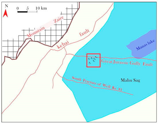
Figure 1.
Study area geographical location.
Influenced by the Kebai overthrust fault zone with syngenetic fracture properties, the buried depth of the Permian–Jurassic reservoir strata significantly differs between the upper and the lower sides of the fault zone. The upper side of the fault zone lacks a Permian system, accompanied by a local lack of Triassic and Jurassic systems. On the lower side of the fault zone, there is integral strata development, and the burial depth increases along the slope zone, accompanied by the thickening of sedimentation. The South Slope District of the Mahu Depression is a large-sized monoclinal structure with a dip angle of 3°–5°. The strata incline toward the southeast. A low-amplitude convex nose is developed in the local areas. The two major fracture groups are as follows: the first is the approximately east-to-west fracture, and the other is the north-to-east fracture.
Relatively complete strata development has occurred in the South Slope District of the Mahu Depression, including the Permian (P), Triassic (T), Jurassic (J), and Cretaceous (K) strata since the Carboniferous–Permian era. Jurassic strata include the Badaowan Formation (J1b), Sangonghe Formation (J1s), Xishanyao Formation (J2x), and Toutunhe Formation (J2t). Specifically, regional unconformable contacts exist between P and T, between T and J, and between J and K (Figure 2). The Sangonghe Formation is divided into three layers (J1s1, J1s2, and J1s3) from the bottom to the top. J1s2 is approximately 110 m thick and is divided into four sand groups: J1s21, J1s22, J1s23, and J1s24. The target stratum J1s24 is mainly composed of fine gray sandstone at the bottom position and dark gray silty mudstone at the upper position, accompanied by local development of mudstone interlayers.
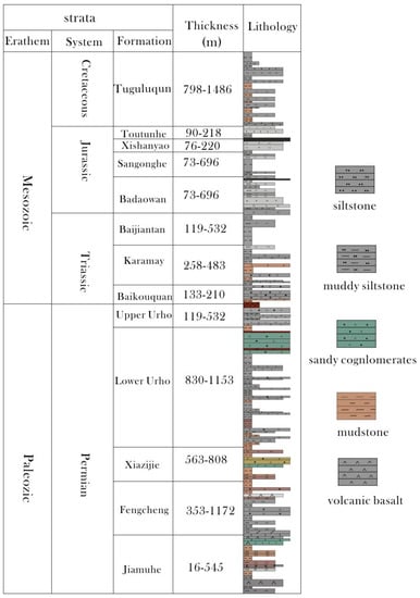
Figure 2.
Comprehensive histogram of strata in the southern slope of Mahu sag.
3. Sedimentary Facies Symbols
3.1. Lithologic Indicator
According to the rock core observations and sheet data, Segment 2 of the Sangonghe Formation in the South Slope District of the Mahu Depression is formed by fine sandstone and siltite, accompanied by a few glutenites. The thin section of the cast shows that the pore type is still dominated by primary intergranular pores, accounting for approximately 80%. Based on core measurement data, the reservoir lithology mainly comprises lithic sandstone with a mean porosity of 20.1% and a mean permeability of 24.43 mD. This lithology belongs to the stratum with middle pores and low permeability. The sandstone structural maturity of the target sandstone is moderate, and the roundness is subangular (Figure 3a). According to the statistical analysis results of the rock sheet samples, the clastic particles include quartz (21.4%) and feldspar (17.8%). Tuff (50%) is the main lithic fragment, and kaolinite is the major type of cement (Figure 3b), followed by the illite/smectite mixed formation. Fine sandstone is mainly distributed in the lower parts of the target stratum, while siltstone and some mudstone dominate the upper portion. This result reveals that the four sand groups at Segments 3 and 2 have relatively strong hydrodynamic conditions in the lower part but relatively weak hydrodynamic conditions in the upper portion. In the sedimentary stage of Segment 3 of the Sangonghe Formation, a large segment of thick dark mudstone developed in the study area. This phenomenon reflects that the gradual deepening of water bodies provides a suitable covering condition for the formation of lithologic oil and gas reservoirs in the target stratum J1s24.
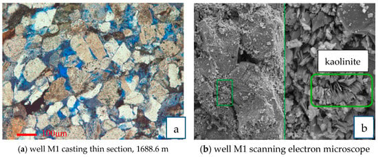
Figure 3.
Slice and scanning electron microscope analysis of cast in wells M1.
3.2. Sedimentary Structure Marks
During the process of sediment transport and deposition, the structures formed during the passage of water inside and on the surface of the sediment are called sedimentary structures, and they are a direct reflection of the hydrodynamic conditions during sediment deposition. According to the coring data analysis of four sand groups at Segment 2 of the Sangonghe Formation in the South Slope District of the Mahu Depression, the scouring surface tectonics were highly developed in the study area, and few mud pebbles can be found at the bottom. Cross-bedding was developed in sandstone, some carbon coheres were scattered around, and several biological disturbance tectonics were developed (Figure 4). These sedimentary tectonics were mainly developed below the target stratum. This finding indicates that the four sand groups in the study area experienced relatively strong hydrodynamic conditions in the sedimentary stage. Sedimentary tectonic structures, such as horizontal bedding, are mainly developed in the upper positions, indicating that the hydrodynamic conditions are weakened, and the watercourse size is narrowed. According to the rock core observations, J1s24 sediments evolved from coarse glutenites to fine mudstones from the bottom to the top, showing positive rhythm characteristics. Scouring surface tectonics can be observed at the bottom of a single-phase cycle. Gray fine sandstones are mainly developed upward. Tabular or wedge-shaped cross-beddings are frequently developed. Gray silty mudstone and some dark gray mudstone developed at the top. Horizontal bedding and some colorful lamina could be observed.
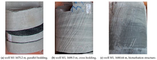
Figure 4.
Sedimentary structure diagram of the second section of the Sangonghe Formation in the study area.
3.3. Logging Phase Marks
Sedimentary sequences were recognized by coring data, and horizons were marked by using the logging curve [8,25]. The lower curve of target stratum J1s24 has obvious response characteristics. The GR and SP curves showed good correspondence, which mainly present bell shapes, box logging curve, and local funnel shapes, and finger shapes. The logging curves at the upper portion of J1s24 are mainly flat, low horizontal, and finger shapes and sometimes dentation shapes (Figure 5).
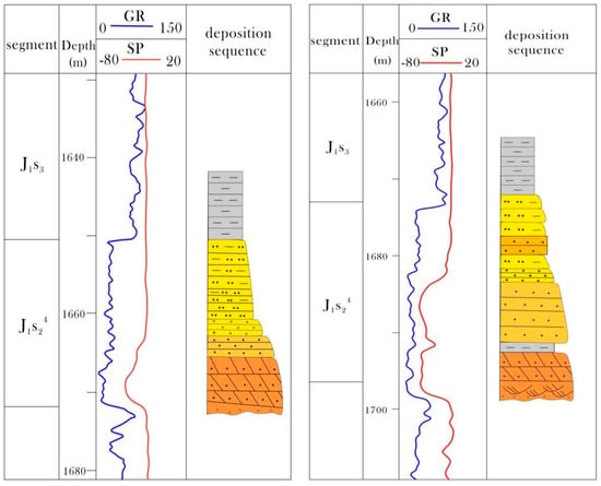
Figure 5.
Logging curve characteristics of target layer.
Fine gray sandstone is developed in the upper portion of the study area with the local development of argillaceous siltstones. The lower part is mainly developed with dark gray siltstone and sandy mudstone with the local development of mudstone interlayers. According to the circulation characteristics of the strata, two middle-term and six short-term rotations were recognized at Segment 2 of the Sangonghe Formation. Four sand groups at Segments 2 and 3 were a sedimentary sequence with gradual lake transgression. Such a segment is formed by the superposition of multiple short-term positive rotations. The grain size is large in the lower part and small in the upper portion. The single sand body has an uneven thickness, ranging between 2 m and 5 m.
4. Types and Characteristics of Sedimentary Microfacies
4.1. Subfacies of the Braided River Delta Front
According to core analysis combined with logging interpretation, logging data analysis, and regional geological background survey [26,27], four sand groups at Segment 2 of the Sangonghe Formation in the South Slope District of the Mahu Depression are formed in the superficial underwater sedimentary environment, and subfacies are sedimented at the front edge of the braided river delta, which is the focus of this study phase band. Four sedimentary microfacies can be further recognized, including the front underwater distributary channel, sheet sand, interdistributary bay, and estuary dam (Figure 6). The underwater distributary channel is the dominant microfacies. Segment 2 of the Sangonghe Formation presents retrogradation sedimentation with lake transgression. The logging curve of underwater distributary channel sediments is bell-shaped, reflecting the positive rhythm characteristics of thinning upward. A certain distance exists from the South Slope District of the Mahu Depression to the provenance, and rivers join with the lake when it enters the study area. This site is the front sedimentation zone of the superficial braided river delta. The front edge of the braided river delta is the major subfacies at Segment 2 of the Sangonghe Formation. In the late stage, prodelta plays the dominant role, mainly deposited with grey oil-bearing fine sandstone, which is the main oil-bearing lithology in the study area. Hence, an effective overlying stratum of lithologic oil–gas reservoirs was formed at Segment 2 of the Sangonghe Formation in the South Slope District of the Mahu Depression.
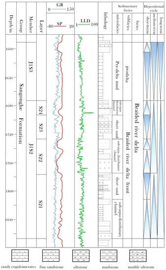
Figure 6.
Comprehensive histogram of the second section of the Sangonghe Formation in the Mahu Sag.
Underwater distributary channels: underwater distributary channels are the underwater extension parts of watercourses in the braided river delta plain [28,29], which is the main reservoir sand body, widely distributed in the work area, with relatively single lithology; GR curves are mostly box, bell, or toothed box shapes. A strong river effect can be observed in the braided river delta. Accordingly, the underwater distributary channel is the major sand body at the front edge of the braided river delta. Underwater distributary channels extensively developed in the study area, and their frequent migrations formed successive sand bodies, which are good oil–gas reservoir bodies. This region is primarily composed of gray lithic sandstone. Sedimentary tectonics have diverse forms: including tabular cross-bedding, scouring surface tectonics, and parallel bedding, and the underwater distributary channel extends from the NE direction to the SW direction with obvious mainstreams.
Estuary dam: This dam is mainly distributed at the far end of the underwater distributary channel. The logging curve of the estuary dam is funnel-shaped and has local development. It is mainly sedimented at the far end of the underwater distributary channel. Gray fine sandstones are the major lithology, and some pebbly sandstones can be seen at the bottom. The core observation is that the fine sandstone development position is accompanied by the development of sedimentary tectonics, such as tabular cross-bedding, scouring surface tectonics, parallel bedding, and biological disturbance tectonics, with occasional carbon dust. Several positive rotation structures that are thick at the bottom and fine at the upper position can be vertically recognized.
Sheet sand: sheet sand is developed on two sides of the watercourse, a thin sand body with sheet-like and narrow strip-like spreading. Relatively fine substances are sedimented, and gray–dark gray siltstones, silty mudstone, and some mudstone are the major lithologies. Corrugated and horizontal beddings are developed, with insignificant rhythms. The logging curves are mainly finger-shaped or low-flat finger-shaped.
Interdistributary Bay: This Bay is mainly distributed among underwater distributary channels and contains fine sediments in environments with relatively hydrodynamic conditions with no obvious rhythm in the vertical direction. Dark and silty mudstones are major lithologies. Horizontal bedding is developed, and the logging curve is relatively straight.
4.2. Prodelta
The upper portion of the oil reservoir is developed with regional overlying strata, which are prodelta sediments, for the four sand groups at Segment 2 of the Sangonghe Formation, with a thickness of approximately 50–90 m. The prodelta subenvironment is located in front of the leading edge of the delta, and most of its sediments are formed below the wave base level, and the water body in the sedimentary environment has weak energy. This condition is manifested as a mudstone sedimentary feature of mega-thick lacustrine facies, and the logging curves are straight.
5. Planar Distribution Laws of Sedimentary Microfacies and Sand Body Characteristics
The steepness of the paleotopographic slope determines the strength of hydrodynamics during deposition: the greater the slope, the stronger the hydrodynamics, the smaller the area of delta it controls; conversely, the smaller the slope, the weaker the hydrodynamics, the larger the area of delta it controls. The slope of the study area is relatively small during the sedimentation stage, and it is the sedimentation background of a gentle slope [30]. A comparative analysis of strata was carried out on more than 80 wells in the study area by combining logging data and seismic model inversion. The framework of four sand groups was established at Segment 2 of the Sangonghe Formation. The sedimentary evolution concerning multiple connecting well profiles was analyzed based on single-well sedimentary phase analysis. The analysis results were combined with the inversion results of the seismic model (Figure 7) to determine the planar distribution characteristics of the sedimentary microfacies in the study area (Figure 8).
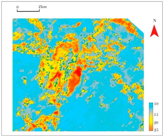
Figure 7.
Inversion results of the second section seismic model of the Sangonghe Formation in the Mahu Sag.
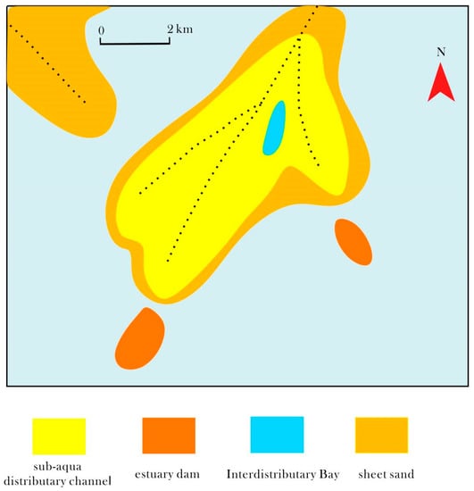
Figure 8.
Sedimentary microfacies plan of the second section of the Sangonghe Formation in the Mahu sag.
Due to the river energy, topographic slope, wave action, and other reasons, different subphase sand distribution shows different characteristics. During the sedimentation stage, the study area was in a superficial lacustrine depositional environment [31]. Subfacies at the front edge of the braided river delta were recognized from four sand groups in the study area, which could be further divided into four sedimentary microfacies, including underwater distributary channel, estuary dam, sheet sand, and interdistributary bay. The underwater distributary channel has extensive development in the working area, and successive sand bodies are formed due to the frequent migration of watercourses. The main watercourse extends from the northeast to the southwest direction in the working area, thus, carrying sediments to two sides of the watercourse. Interdistributary bay deposits are distributed among channels. Estuary dams are mainly developed at the far end of the channel. Sheet sand has extensive development, but it is relatively thin. In the early sedimentation stage of Segments 2 the Sangonghe Formation in the South Slope District of the Mahu Depression, underwater distributary channels are the major deposit types in the study area. Successive sand bodies are developed. Moreover, an estuary dam is developed at the front end of the underwater distributary channel, and sheet sand is hardly developed. At this moment, the lake level is the lowest, and the material source is sufficient. Gray fine sands are the major deposits, and the sand content is 70–80%. In the late stage, the coastline migrated to the provenance with increasing lake levels. During this stage, underwater distributary channels gradually retrograded, accompanied by gradual development of interdistributary bays and sheet sand, with deposits of gray argillaceous siltstones and interbay muds.
Using a combination of literature research, core observations, and log phase analysis, given the phase-controlled conditions, the typical single-well sedimentary sequence levels in the study area and the superposition relations of sand bodies were investigated using core observation and logging data combined with seismic model reversion technology. On this basis, the inter-well sand body contact laws could be concluded. The results showed the following:
- (1)
- The slope of the study area is small, and multiple faults can be found along the provenance direction, forming multilevel slope gradients. The sand bodies gradually thicken from northeast to southwest. As the water continues to advance toward the center of the depression, the sand body gradually thins out again. Hence, the delta scale is relatively small, and sand bodies are wedged along the provenance direction but show lenticular morphologies with uneven thickness perpendicular to the provenance direction.
- (2)
- The interwoven submerged divergent channel sand bodies are formed by the continuous bifurcation and merging of the main submerged divergent channels and during the continuous migration of the channels, separation, replacement, lateral superposition, and vertical superposition modes, contact relationships are formed between single sand bodies in multistage channels. In regions with the development of underwater distributary channels, sand bodies are mainly lateral and vertical superposition modes, which can form composite sand bodies. This region often has high oil and gas yields and good development benefits. According to the inversion results of the seismic model, sand body developments at the northern region of the fault in the large Jurassic Valley are put into production.
6. Conclusions
Single sand bodies are carefully divided by depicting sedimentary microfacies at Segment 2 of the Sangonghe Formation in the South Slope District of the Mahu Depression in combination with the seismic inversion results. Some conclusions can be drawn:
- (1)
- Four sand groups in the study area are front-edge sediments in the braided river delta under the gentle slope background. Furthermore, four sedimentary microfacies can be recognized. Few developments of estuary dams are mainly at the far end of underwater distributary channels. Sand bodies in the underwater distributary channels are major reservoir bodies. Fine lithic sandstone is the main lithology, and the sedimentary tectonics have diverse forms.
- (2)
- Based on the knowledge of the sedimentary phase at the well site, combined with the seismic model inversion results, it is concluded that: diversion and bifurcation of the underwater distributary channel are regularly modified and created under phase control conditions. In the middle of the work area, a continuous oil-bearing sand body is formed by accumulation, which is the dominant phase zone; the sand bodies mainly form vertical and lateral superpositions to form composite sand bodies. Composite sand bodies mainly have general connections.
- (3)
- The fine sandstone reservoir in the study area and the thick dark mudstone overlying strata of Segment 3 of the Sangonghe Formation form the reservoir-overlying combination, which is extensively developed in the study area. Lithologic oil–gas reservoirs can be easily formed and are considered to be promising exploration areas.
Author Contributions
Conceptualization; investigation; writing—original draft; data curation, L.L.; methodology, software, validation, F.G.; funding acquisition, Y.Q.; formal analysis, J.M. All authors have read and agreed to the published version of the manuscript.
Funding
This research received no external funding.
Institutional Review Board Statement
Not applicable.
Informed Consent Statement
Not applicable.
Data Availability Statement
No research data.
Conflicts of Interest
The authors declare no conflict of interest.
References
- McPherson, J.G.; Shanmugam, G.; Moiola, R.J. Fan-deltas and braid deltas: Varieties of coarse-grained deltas. GSA Bull. 1987, 99, 331–340. [Google Scholar] [CrossRef]
- Yu, X.H.; Wang, D.F.; Sun, Z.H. Lithofacies Types, Vertical Profile Features and Geological Models of Braided Deltaic Sandbodies in Fauled Lake Basin—The Observation on Deposition of Modern Deltas in Daihai Lake, Inner Mongolia. Acta Sedimentol. Sin. 1995, 1, 48–58. [Google Scholar]
- Zhou, H.R.; Wang, X.L.; Liu, Z.R. Braided river delta sediments of the Huangshanjie Formation of Upper Triassic in southern Junggar Basin. J. Palaeogeogr. 2006, 8, 187–198. [Google Scholar]
- Li, S.M.; Song, X.M.; Liu, Y.Q.; Wang, Y.Q.; Li, Y.; Tang, H.J. Depositional models of regressive and progressive shoal braided deltas in Wenmi Oilfield. J. Jilin Univ. Earth Sci. Ed. 2011, 41, 665–672. [Google Scholar]
- Xu, M.; Wang, J.; Xu, D.H. The sandbody evolution of shallow-water braided river deltas in the Eighth Member of Shihezi Formation in Block Su120, Sulige Gas Field. Acta Pet. Sin. 2013, 99, 331–340. [Google Scholar]
- Feng, C.J.; Bao, Z.D.; Shan, Q.T. Single sand body identification in compound distributary channel of delta plain: A case study from the fourth member of Quantou Formation in the southern part of central Fuyu oilfield. Oil Gas Geol. 2012, 33, 77–83. [Google Scholar]
- Jin, Z.K.; Li, Y.; Gao, B.S.; Song, B.Q.; He, Y.H.; Shi, L.; Li, G.Z. Depositional model of modern gentle-slope delta: A case study from Ganjiang Delta in Poyang Lake. Acta Pet. Sin. 2014, 32, 710–720. [Google Scholar]
- Wang, H.; Wu, X.; Li, T. Sedimentary Characteristics of Sangonghe Formation of Jurassic in Northwest Margin of Junggar Basin. XinJiang Geol. 2020, 38, 66–70. [Google Scholar]
- Tang, Y.; Guo, W.J.; Wang, X.T. A new breakthrough in exploration of large conglomerate oil province in Mahu Sag and its implications. Xinjiang Pet. Geol. 2018, 40, 127–137. [Google Scholar]
- Zhi, D.M.; Tang, Y.; Zheng, M.L.; Guo, W. Discovery, distribution and exploration practice of large oil provinces of above source conglomerate in Mahu Sag. Xinjiang Pet. Geol. 2018, 39, 1–8. [Google Scholar]
- Chen, L.; Ding, J.; Pan, W.Q.; Chen, T.; Jiang, J. Characteristics and Controlling Factors of High-quality Dolomite Reservoir in Permian Fengcheng Formation in West Slope of Mahu Sag, Junggar Basin. China Pet. Explor. 2012, 17, 8–11+7. [Google Scholar]
- Hu, X.; Qu, Y.Q.; Hu, S.Y.; Pan, J.; Yin, L.; Xu, D.; Teng, T.Y.; Wang, B. Geological conditions and exploration potential of shallow oil and gas in slope area of Mahu Sag, Junggar Basin. Lithol. Res. 2020, 32, 67–77. [Google Scholar]
- Zhi, D.; Liu, M.; Chen, X.; Said, N.; Tang, W.; Hu, C.; Qin, Z.; Zou, H.; Gong, D. Stratigraphic Characteristics and Sediment-Filling Process of the Early Permian Fengcheng Formation in the Northwestern Margin of the Junggar Basin, Northwest China. Front. Earth Sci. 2022, 10. [Google Scholar] [CrossRef]
- Wu, Y.; Liu, C.; Jiang, F.; Hu, T.; Lv, J.; Zhang, C.; Guo, X.; Huang, L.; Hu, M.; Huang, R.; et al. Geological characteristics and shale oil potential of alkaline lacustrine source rock in Fengcheng Formation of the Mahu Sag, Junggar Basin, Western China. J. Pet. Sci. Eng. 2022, 216. [Google Scholar] [CrossRef]
- Chen, Y.B.; Pan, J.G.; Zhang, H. Characteristics of Fault Evolution in Mahu Slope Area of Jungger Basin and Its Implications to the Reservoir in the Lower Triassic Baikouquan Formation. Nat. Gas Geosci. 2015, 26, 11–24. [Google Scholar]
- Liang, Y.; Zhang, Y.; Chen, S.; Guo, Z.; Tang, W. Controls of a strike-slip fault system on the tectonic inversion of the Mahu depression at the northwestern margin of the Junggar Basin, NW China. J. Asian Earth Sci. 2020, 198, 104229. [Google Scholar] [CrossRef]
- Zhang, C.M.; Yin, T.J.; Tang, Y. Advances in sedimentological reservoir research in Mahu sag and northwest margin of Junggar Basin. J. Palaeogeogr. 2020, 22, 129–146. [Google Scholar]
- Hou, G.F.; Xu, Y.; Sun, J. Sedimentary model from delta front to deep water area and its significance:a case study of the first sand group of Member 2 of Sangonghe Formation in the Well Pen-1 West Sag, Junggar Basin. Acta Sin. 2019, 40, 1223–1232. [Google Scholar]
- Zhang, Y.Q.; Zhang, N.F.; Yao, X.Y. Review and Prospect for Petroleum Exploration in Hinterland of Junggar Basin. Xinjiang Pet. Geol. 2000, 21, 105–109+169. [Google Scholar]
- Qiu, Z.K.; Wu, R.B.; Li, W. Reservoir Characteristics of Jurassic Sangonghe Formation in Northwest Margin of Mahu Depression. Xinjiang Geol. 2020, 38, 378–382. [Google Scholar]
- Zhao, W.Z.; He, D.F.; Song, Y. Fundamental Characteristics of Petroleum Geology of Major Onland Petroleum-bearing Basin in China. Geol. Rev. 1999, 45, 232–240. [Google Scholar]
- Hou, G.F.; Wu, A.C.; Zhou, Z.W. Depositional Characteristics and Models of Braided River Delta in Badaowan Formation of Mahu Sag, Junggar Basin. Xinjiang Pet. Geol. 2017, 38, 678–685. [Google Scholar]
- Wang, H.; Hou, W.F.; Li, T. Control of slope break on sedimentary facies in foreland basin: A case study of Sangonghe Formation in northwestern margin of Junggar Basin. J. Cent. South Univ Sci. Technol. 2022, 53, 1136–1145. [Google Scholar]
- Yang, F.; Cao, Z.L.; Wei, Y.Z. Sedimentary characteristics of shallow-water braided delta of Karamay Formation in Mahu area. Lithol. Res. 2019, 31, 30–39. [Google Scholar]
- Lei, B.J.; Li, Y.G.; Li, F.P. Sedimentary microfacies and sandbody distribution of the Member 8 of Xiashihezi Formation in horizontal well zone, central Sulige area, Ordos Basin. J. Palaeogeogr. 2015, 17, 91–105. [Google Scholar]
- Li, Y.; Fan, A.; Yang, R.; Sun, Y.; Lenhardt, N. Braided deltas and diagenetic control on tight sandstone reservoirs: A case study on the Permian Lower Shihezi Formation in the southern Ordos Basin (central China). Sediment. Geol. 2022, 435, 106156. [Google Scholar] [CrossRef]
- Zhu, X.M.; Zhang, Y.N.; Yang, J.S. Sedimentary characteristics of the shallow Jurassic braided river delta, the Junggar Basin. Oil Gas Geol. 2008, 29, 244–251. [Google Scholar]
- Xia, S.Q.; Liu, Z.; Luo, D.H. Sequence architecture and depositional evolution in Lufeng Depression, Pearl River Mouth Basin, South China Sea Part A:The braided delta deposits of Cenozoic Enping Formation. Geol. J. 2018, 53, 2779–2794. [Google Scholar] [CrossRef]
- Liu, X.L. Sedimentary microfacies of the first member of Badaowan Formation in Mahu Sag, Junggar Basin: Taking well TX1 as an example. Sediment. Geol. Tethyan Geol. 2021, 41, 100–105. [Google Scholar]
- Qiu, Z.K.; He, N.X.; Wang, H.; Li, X.; Li, T.; Zhou, Q.; Wu, X.; Shi, L. The sedimentological reservoir characteristics of the Jurassic Sangonghe Formation, Southern Mahu Slope, Junggar Basin, Northwestern China. Geol. J. 2020, 56, 1478–1495. [Google Scholar] [CrossRef]
- Liu, W.F.; Zhang, X.S.; Liu, J.M. Sedimentary Characteristics of the Triassic Baijiantan Formation in the Western Slope Area of the Mahu Depression. Acta Sedimentol. Sin. 2022, 40, 192–202. [Google Scholar]
Disclaimer/Publisher’s Note: The statements, opinions and data contained in all publications are solely those of the individual author(s) and contributor(s) and not of MDPI and/or the editor(s). MDPI and/or the editor(s) disclaim responsibility for any injury to people or property resulting from any ideas, methods, instructions or products referred to in the content. |
© 2023 by the authors. Licensee MDPI, Basel, Switzerland. This article is an open access article distributed under the terms and conditions of the Creative Commons Attribution (CC BY) license (https://creativecommons.org/licenses/by/4.0/).