Article

A Transect Method for Promoting Landscape Conservation in the Climate Change Context: A Case-Study in Greece

by
Vassiliki Vlami
1,
Ioannis P. Kokkoris
2,*,
Ioannis Charalampopoulos
3,
Thomas Doxiadis
4,
Christos Giannakopoulos
5 and
Miltiades Lazoglou
1
1
ELLINIKI ETAIRIA Society for the Environment and Cultural Heritage, 10558 Athens, Greece
2
Laboratory of Botany, Department of Biology, University of Patras, 26504 Patras, Greece
3
Laboratory of General and Agricultural Meteorology, Department of Crop Science, Agricultural University of Athens, 11855 Athens, Greece
4
Doxiadis+ Architects Landscape Architects, 10557 Athens, Greece
5
Institute for Environmental Research and Sustainable Development, National Observatory of Athens, 15236 Athens, Greece
*
Author to whom correspondence should be addressed.
Sustainability 2023, 15(17), 13266; https://doi.org/10.3390/su151713266
Submission received: 26 July 2023 / Revised: 28 August 2023 / Accepted: 29 August 2023 / Published: 4 September 2023

Abstract

:
Within an EU Life project aiming to boost climate change adaptation in Greece, this study develops a transect method for rapid landscape-scale assessment. The procedure applies a holistic assessment of terrestrial landscapes at three spatial scales: a broad cross-section transect zone through the Peloponnese peninsula (240 km long, 1.416.6 km2) and successively the delineation of 35 selected landscape areas and the associated landscape views. Climate change scenarios and relevant indices were incorporated to screen for climate and anthropogenic impacts, including phytoclimatic, erosion and wildfire analyses. The climatic and bioclimatic conditions were examined in three time periods (reference period: 1970–2000 and in the future periods 2031–2060 and 2071–2100). Based on the above framework, the climate change adaptation planning process is reviewed including the Regional Adaptation Action Plan (RAAP) of the Peloponnese Region. The results of this method application effectively assess both the “territorial” and “perceptual” aspects of the selected landscapes; mapping the potential threats, interpreting problems, identifying knowledge gaps and prioritizing vulnerable areas. Analyses show that combined land-use pressures and climatic shifts will cause landscape change, particularly evident in an increase of wildfires, in the near future. Currently, poor conservation measures do not adequately protect landscapes in most areas of the study from expanding anthropogenic pressures (urban sprawl, wetland draining, etc.); these conditions may further aggravate environmental safety concerns during future climate change conditions. The review also documents poor attention to landscape conservation within the current RAAP report. The proposed transect method may assist in promoting landscape appreciation by setting an “enabling framework” for landscape-scale conservation planning during the climate change adaptation process.

1. Introduction

Landscape assessment presents a diversity of approaches and inherent complexity. The concept of landscape assessment includes the “whole” mosaic of land, documenting biodiversity, human land uses, cultural manifestations and subjective human perceptions [1]. The landscape has traditionally been reduced and analyzed into separate parts, for example, ecosystem types, vegetation formations, land cover and land-use types that make up landscape mosaics [2]. As a result, landscape-based research and conservation efforts have encountered problems with standardization and implementation [3,4]. In recent years, more holistic and interdisciplinary initiatives for landscape-scale assessments have been gaining interest [5,6,7]. Landscape science and practical land management continuously evolve, as do ways of incorporating them into conservation and planning [8,9].
The landscape perspective is critically important in land-use planning, heritage and nature conservation, including recent reference to climate change [10,11,12,13,14]. Differing perspectives from different disciplines have produced various methods of landscape study and attempts towards an integration of methods, including the use of ecosystem services [4,15,16]. Reference to landscape has recently been firmly established in environmental assessment [17], and landscape ecology has influenced many aspects of applied land management [18]. In recent years, there has been an increased effort to track landscape changes in time and space within the realm of conservation and sustainable planning [19,20]. It has become common knowledge that landscape areas should be defined in terms of spatial and temporal scales [21]. At narrow spatial scales, human and natural disturbances control patterns, while at broader scales (and longer time intervals), climate and topography are the driving forces [22]. In biodiversity conservation planning, even the specific interests of endangered species often depend ultimately on the wider landscape conditions. Freshwater-related biodiversity strongly depends on the surrounding landscape structure and land uses besides locally protected habitats [23]. Since anthropogenic degradation is all-pervasive over most of the Earth’s surface, appreciating a multitude of interconnections at the wider “wholescape” scale [24] is critically important for effective conservation and restoration planning. Techniques and practical know-how, often based on landscape ecology, are building many new approaches for managing the wider landscape, with stronger policy-relevant foundations [25,26]. However, is landscape conservation adequately appreciated in climate change adaptation planning?
Climatic variability and the effects of climate change may bring significant and uncertain changes in landscapes, and there have been climate adaptation studies in recent years that refer to the complexities of influencing future landscape change in a climate context (e.g., [27,28,29,30]). Efforts for conserving landscapes are particularly challenging [13,31]. It is never as simple as “what changes should be permitted or encouraged versus what landscape features should be conserved”. Fortunately, there has been a recent emergence of relevant policy-relevant initiatives [9,14,25]. In Europe, a new momentum for the role of landscape both in institutional policies and in the public interest arose from the enactment of the European Landscape Convention by the Council of Europe in the year 2000 [32]. Efforts towards climate adaptation must emphasize specific solutions that increase resilience in the face of climate change, but systematic advice at the local landscape scale is not yet widespread [25,33]. Practical progress in bringing landscape appreciation to the fore has been mixed; many commentators agree that further policy reforms will be required [14,31,34]. Even within some regions in Europe, there is a scarcity of initiatives that combine landscape conservation with climate change adaptation.
In Greece, for example, there has been increasing landscape research, especially after the ratification of the European Landscape Convention in 2010, but landscape conservation in practice has been difficult to develop and enforce [35,36]. Recent reviews show that there is a surprising lack of landscape appreciation in Greece (e.g., [37,38]), and examples of severe landscape-level degradation are widespread, even within protected areas [39,40,41]. Landscape issues have scarcely been considered in climate resilience proposals. A National Action Plan for adaptation to climate change has been developed in the form of 13 Regional Adaptation Action Plans (RAAPs). Greece’s RAAPs were recently finalized and will have a seven-year monitoring cycle. Each RAAP will include potential adaptation measures at the regional level, taking into account regional and local specificities and indicating specific actions per sector or sub-regional area wherever necessary [42]. Unfortunately, there is still very little specific account of landscape values and broader landscape conservation within the RAAPs in Greece. Most climate adaptation work focuses traditionally on sectoral analyses. This problem has also been seen in other Mediterranean countries where planning procedures also rarely refer to landscape issues in the climate change context [43].
One way to bring landscape issues within the climate change planning sphere, even in conditions of uncertainty, refers to the need for landscape inventory and assessment. Studying landscapes should promote their wider appreciation. In a rapid assessment approach, the “sampling” of landscapes may be accomplished using transects [44,45]. The concept of using transects to describe landscapes was brilliantly initiated by Alexander Von Humbolt in the early 19th Century [46], and it has seen varied uses through the years [47,48]. The landscape architects Duany and Talen (2002) [49] give a broad definition of a transect: “a geographical cross-section of a region used to reveal a sequence of environments”. Modern efforts to apply transect approaches at the broader scale of landscapes are few and poorly standardized [45,48], but they may have gained a wider interest recently [46,50,51].
The present research is a case study that develops and applies a procedure for the rapid assessment of landscape conditions along a geographical transect in Southern Greece. This landscape inventory work is imbued with climate data analyses. In this way, the potential climate change effects and changes are assessed at the local landscape-scale by examining climate models and scenarios and assessing specific landscape areas and landscape vistas. The main goal is to report on the initial development of a simple landscape transect method which would support landscape-scale assessments in the climate change adaptation context. This survey methodology may help scientists and conservation practitioners to become creatively engaged in landscape-scale conservation initiatives which may propose practical solutions of local and regional interest in climate change adaptation and mitigation planning.

Aims of the Study

This study attempts a holistic procedure within a rapid landscape assessment within a project reviewing the future impacts of climate change, including recommendations and initiatives concerning landscape conservation. The evaluation and development of the project is completed in a limited time period (approximately six months) in the context of a rapid overview in order to examine the impacts and draw up proposals related to climate change adaptation in a specific regional setting. For this reason, so-called landscape “sampling” techniques were used. The sampling technique rationale rests on the transect method, i.e., a linear sample study area, crossing many different landscapes and different climate zones through a region.
The aims of this paper focus on the development and case study results of a rapid method for reviewing and assessing both a wide variety of landscapes and the potential impact of climate change within the policy-relevant context of climate change adaptation and mitigation. The study focuses on the development of inventory and information gathering on landscapes both as physical spatial (territorial) and visual (perceptual-scenic) entities. Combining the landscape research with the climate data analyses and the assessment in the entire transect area, this research aims to contribute to many aspects of the knowledge and understanding of landscapes as well as specific steps related to the specialization of climate change adaptation issues. The survey should be able to provide a review of regional adaptation policies that have already been set through the Regional Adaptation Action Plans (RAAPs) of the administrative regional government of the Peloponnese Region. This kind of survey should provide a boost of support for the promotion of adaptation measures for landscapes. It should also identify gaps and priorities to ameliorate the regional action plan framework.

2. Material and Methods

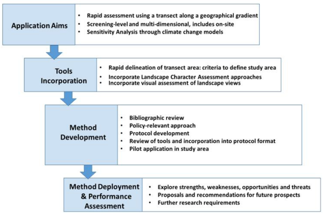
2.1. Methodological Background

In the present study, a landscape transect method is developed and used to promote an approach for landscape study and assessment by investigating linear “samples” of a region with different landscapes along a longitudinal sequence. The spatial study area and sampling method is to inventory landscape qualities and sensitivities along a gradient of change over a much larger area than a few specific landscapes; a regional area coverage. A wider zoned approach is important for this kind of work [47], since the landscape cannot be a point on a line.
Since there is practically no complete description of a “landscape transect method” in a climate change context, though there are some isolated and heterogeneous efforts, it is important to briefly review the literature on transect studies. In a general sense, the transect method has been widely used in a multitude of forms as a standard method in geography, ecology, agronomy, archeology and other sciences to systematically describe a “sampling” or a representative linear sample of space [48]. Despite its long history in urban planning projects there is little academic research and little published literature on the application of the transect method to a wider landscape or countryside [46]. Beyond the multidimensional space of the countryside landscape, the use of the transect has been more frequently applied in landscape architecture and mainly in urban spaces at narrow spatial scales [49]. In the longitudinal swathe of a transect study area, spatio-temporal changes and different scenarios are of interest, especially where there is considerable uncertainty. The transect concept may thus be useful to depict patterns over varied territory, promoting alternative situations, different scenarios and future projections [51]. These do include some recent resilience projects in order to prepare plans for future uncertainties that may arise from climate change [46,52,53].
The transect method in landscape research and architecture often centers on planning; it aims to help investigate the sequence of places and landscapes by “sampling” places and presenting alternative states of development. In 2002, Duany and Tallen refer to “transect planning” [49]. For them, the idea of a transect is fundamental to the investigation, understanding and deepening of the character of urban space. This methodology expands to include the wider landscape context. Technology also has played an important role in promoting such layered and multifaceted spatial analyses at broader spatial scales beyond the urban areas, including the spread of geographic information systems (GIS), especially after the early 1990s.

2.2. Developing the “Landscape Transect Method” for Climate Change Study

The transect method development procedure may be defined within steps, as in Figure 1. Initially, the development of the method within the present application reviews rapid landscape analysis procedures based on the aims of the project. Tools and protocols are structured and tested. Subsequently, the classification of landscapes (typology of landscapes) was examined, as was the analysis of climate change scenarios and specific indices. Further, there is reference to various approaches to vulnerability investigation and their evaluation and documentation in the climate change context. The concept of vulnerability of different types of landscapes, landscape formations, ecosystems and land uses may help to prioritize requirements and local needs for climate adaptation. Finally, a basic reference is also made to the adaptation policies that have already been set (e.g., the Regional Adaptation Action Plans (RAAPs) for the Peloponnese). The review assists with commentary and suggestions after the analysis of the local conditions in the context of the transect area. Finally, the method is assessed and any difficulties are presented.
The proposed transect should be chosen according to a set of criteria, as has been done in other geographical transect approaches (e.g., [46,54]). Following a review of the bibliography, we recommend certain aspects related to the transect form and orientation:
(1)
The transect zone is sufficiently broad that: (i) understanding gained from research on the transect can be applied beyond a narrow spatial sector, and (ii) it crosses a transition between systems dominated by different major ecosystems (e.g., forest/prairie, mountains/lowlands) and climate zones.
(2)
The transect is located in a region that is likely to be altered by forcing from components of global environmental change, where the alteration is itself likely to be significant at least at the regional level.
(3)
The transect represents a coherent set of sites that differ relatively straightforwardly and continuously in a major environmental factor that is predicted to change significantly (or has already changed) as a consequence of environmental change (anthropogenic or otherwise).
One of the novelties of the approach in this study is that the carefully delineated landscape areas are “samples” of landscapes within the transect zone. The selection and delineating of such landscape areas is a subjective process (based on expert judgement). Based on the bibliography and past experience, the following criteria are taken into account for landscape area identification and delineation:
-
Topography and landscape relief
-
Watershed boundaries
-
Dominant land use formations
-
Current vegetation patterns
-
Dominant ecosystems (e.g., natural patterns)
-
Perceptual characteristics (e.g., common character area).
Delineation and investigation (information gathering) include both in-house office and field study. These are summarized as follows:
(a)
Desk study:
  • Gathering information from the literature and web review and GIS databases as in other nationwide published analyses [16,39,55]. More specifically, information was collected for the landscape and land-use characteristics of the transect area:
-
Land cover and land uses (Corine CLC and Google Earth);
-
Natural drainage basin boundaries determined by watershed boundaries;
-
Protected or designated area boundaries;
-
People’s perceptions of the points of view within a landscape area (on-line georeferenced photos, Google Earth photos);
-
Other information gathering from discussions with experts and local citizens.
(b)
Field study:
-
Confirmation of the final borders of the selected landscape areas and the landscape points (analysis of drone video footage). The limits of each landscape area depend on the topography and the extent of homogeneous landscape formations in the area. A very important horizon “border” of the landscape is the watershed boundary; on hills and mountain ridges.
The aim of the landscape assessment protocol is to record the identification and evaluation in the field. The purpose of using a protocol is the systematic assessment of the landscape conditions with the purpose of the qualitative and quantitative recording (descriptive statistics). The main and central assessment of each area are the four main landscape values: ecological, economic, cultural and perceptual; as documented in the current life project studies [56].

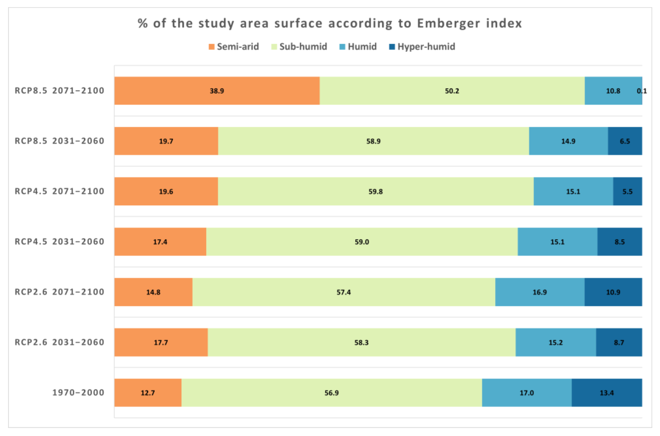
2.3. The Climate Change Assessment Methodology

The climatic and bioclimatic conditions have been examined in three time periods. In the transect zone area, bioclimatic data were projected for the reference period (1970–2000), plus the future periods of 2030–2061 and 2071–2100. For the post-report periods, three scenarios of greenhouse gas emissions (RCPs) were examined. More specifically, the first scenario, RCP2.6, assumes that the maximum of the global greenhouse gas emissions will occur in the decade of 2010–2020 and then a significant reduction will follow. According to the second climate change moderate scenario, RCP4.5, greenhouse gas emissions will increase until 2040 and then decline. Third, in the RCP8.5, the extreme high-emissions scenario, greenhouse gas emissions will continue to rise throughout the 21st century.
The climatic parameters analyzed for this study were the air temperature (mean, max, min), the precipitation, the yearly number of heavy rain (p ≥ 20 mm) and the dry days of the year (p < 1 mm) along with the consecutive dry days (dry spell). Moreover, for the scope of this study, we analyzed the sunshine duration (hr), the relative humidity (%), the wind speed (m/s), the evaporation (mm) and the days of fog and frost. The National Observatory of Athens (NOA) provided 500 m spatial resolution data for the three time periods under three climate scenarios to monitor the changes in the transect’s bioclimatic conditions.
Various indices were used to screen for vulnerability to climate change; the basic bioclimatic indices are the Emberger Bioclimatic Index and the de Martonne Index. Using the Canadian Fire Weather Index (FWI), we identified high fire risk conditions and we also applied the Environmentally Sensitive Areas desertification index (ESA). For economy of publishing space in this publication, we choose to present the results of the variation of the precipitation, the dry days and the dry spell days for all the time periods and for the RCP4.5 and RCP8.5 emissions scenarios. Moreover, we concentrate on results using the Emberger bioclimatic index, which categorizes the different bioclimate zones in the Mediterranean region using a system that ranges from “hyper arid” to “hyper humid”, based on two key climatic factors: temperature and precipitation (Table 1). Given that vegetation development is directly related to these thermal boundaries, the temperature is expressed annually by the average maximum temperatures of the warmest month (M) and the average minimum temperatures of the coldest month (m). The index uses temperature extremes in its calculation, which considers the temperature variability of the studied region. The temperature is calculated as the ratio (M + m)/2. The annual values of precipitation (P) represent the available water by rainfall [57,58].
For the assessment of the bioclimatic conditions of the cross-section area, the Emberger index (IEMB), commonly termed as the pluviothermic quotient (Q) (Table 1), was applied and computed on an annual basis, according to the following formula:
I E M B = Q = 1000 × P M + m 2 × ( M m ) Q = 2000 × P M 2 m 2
where:
-
P: represents the annual average precipitation (mm);
-
M: represents the average maximum monthly air temperature of the warmest month in absolute degrees (K);
-
m: represents the average minimum monthly air temperature of the coldest month in absolute degrees (K).
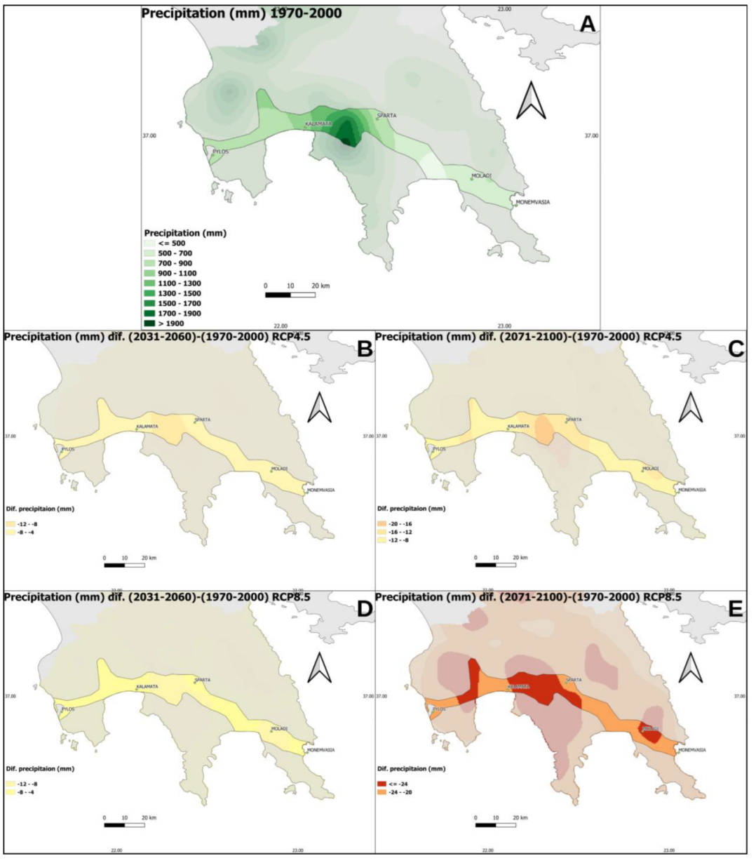
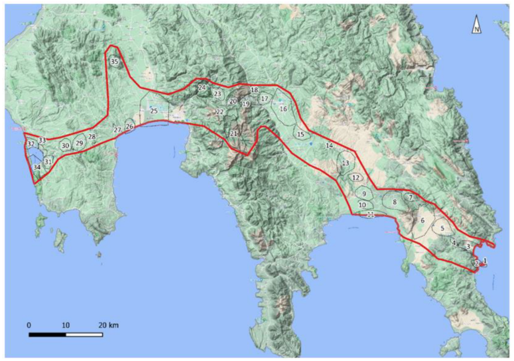
2.4. The Study Area

This is the first of the case studies of the LIFE IP C4D1 [60] organized by the one of Greece’s oldest environmental NGOs, the ELLINIKI ETAIRIA Society for the Environment and Cultural Heritage, within the EU project LIFE-IP AdaptInGR–Boosting the implementation of adaptation policy across Greece (see Acknowledgements). The study focuses on the Peloponnese peninsula, an area of recognized cultural and natural importance. The delineated transect area occupies 1.416, 7 km2 and runs through the southern Peloponnese on the east–west axis, starting from Monemvasia and ending up at Gialova Lagoon near Pylos (Figure 2). Administratively, it runs through the prefectures of Laconia and Messenia and their capitals, Sparta and Kalamata, respectively. Due to the time constraints of this pilot application, this research does not include coastline and marine areas but does include the islets of Monemvasia and Sfakteria at Pylos Bay.
The linear transect crossing itself is a rather arbitrary delineation because there is not just one way to travel from Monemvasia to Pylos. The old provincial road connecting Pylos–Kalamata–Sparta (via Taygetos) was chosen, and then the Evrotas Valley to the Evrotas Delta. Then, from the estuary of Evrotas, the old provincial road to Monemvasia was used. Finally, Ancient Messene was added, connected by the old country road between Kalamata and Pylos. The total cross-section route (including the bypasses near the road) is approximately 240 km long. The cross-sectional area runs through a wide variety of topography, elevations, vegetation units and land uses, so it also presents a wide variety of landscapes. The altitude ranges from zero meters above sea level and to approximately 2.030 m, on Mount Taygetos. The average elevation of the transect is 353 m and the average slope of the surfaces is 20%. It is noted that extensive plains prevail in places, but also steep, vertical rocks, mainly on the slopes of Mount Taygetos, in the small canyons and on the rocky outcrops of the relief of the entire area.
The collection of information was conducted in the study area of the transect, in order to monitor the changes in the area’s landscapes at an intermediate spatial scale (e.g., a relatively broad scale but which hierarchically includes other narrow scales of analysis such as landscape areas and viewing points). The transect offers the possibility of capturing and analyzing without losing the geographical and geomorphological continuity, both for the existing situation and the possible changes resulting from climate change. Finally landscape points were selected that offer access and views to each landscape area for evaluation. A total of 35 area points have been selected, one for each landscape area.

3. Results

3.1. Landscape in the RAAP

The main objective of RAAP of the Peloponnese [60] is to contribute to strengthening the region’s resilience against climate change’s effects through a series of measures and proposals. The present study’s review documents that reference to the wider landscape is minimal in the main report. The focus of this work strongly on sectoral aspects, integrative approaches concerning the landscape are not developed. A simple search of the word “Landscape” (τοπίο in Greek) in the 843 pages of the main report reveals only 17 instances of the use of the word; and, very few have any practical relevance to applied measures for conservation and management (Appendix A Table A1).

3.2. Applying the Descriptive and Landscape Assessment Protocols

Once viewpoints were selected the potential for getting a specific on-site data for each landscape area was achieved (Figure 3). From the 35 selected viewpoints the majority of the entire transect was visible (Figure 4). Two protocols were completed in the field from each viewing position: (a) application of the ELLET landscape protocol and (b) application of the Landscape Assessment Protocol (LAP). Both researchers participated in completing them in the field (i.e., they decided collectively on the assessments and scoring). Nearly all site were also photographed using a drone.
The ELLET landscape protocol follows the tradition of LCA field forms and is descriptive. Along the transect it is rather easy to interpret the relative degree of landscape quality as provided by the LAP index in the 35 selected viewpoints (Figure 5); although the number of samples required is not easily validated in such a survey. The LAP landscape assessment index offers a semi-quantitative assessment of the perceptual features of the selected landscapes, it is also important due to lack of any other on-site rapid assessment index.

3.3. Landscape Typology

Using the remote sensing resources and data from the field visit a simple typology was completed (Figure 6). Six landscape types are defined based on their climate relevant altitude, dominant vegetation, land cover and other attributes. The general typological units also reflect on climate change conditions as provided by the climate models (Figure 7, Figure 8, Figure 9 and Figure 10).

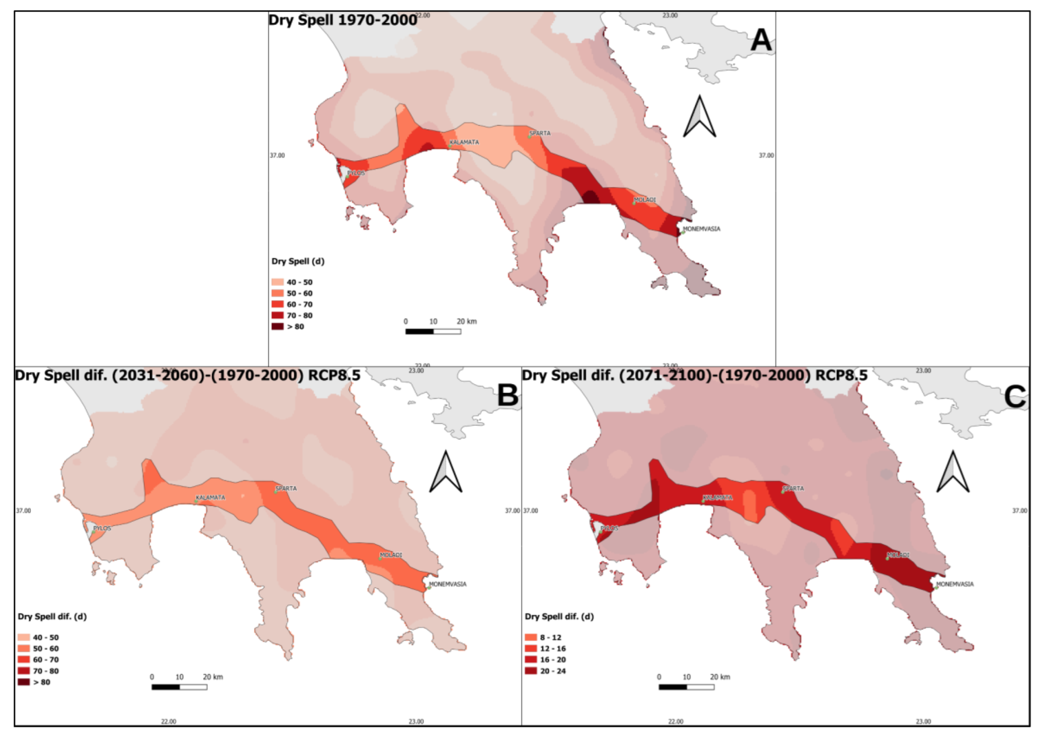
3.4. Climate Change Impacts

In the following Figure 10, the bioclimatic conditions are becoming increasingly dry and hot in the transect area, as shown by the Emberger index. More specifically, in the RCP8.5 scenario, representing the most increased GHG emissions during the period 2071–2100, the semi-arid category occupies almost three times the area compared to the reference period (1970–2000). For the same period and scenario, it is observed that the hyper-humid bioclimatic category almost disappeared (0.1%), while during the reference period, it reached 13.4%. It should be noted that this category was found in the mountainous area of Taygetos, where forest cover dominates much of the land area. For the same scenario in 2031–2060, there is again a significant increase in the semi-arid category. At the same time, a significant decrease in the hyper-humid category and a smaller decrease in the humid category is recorded compared to the reference period. In the RCP4.5 scenario, there is again a trend towards drier and warmer conditions. Concerning the RCP2.6 scenario, there do not appear to be significant differences.

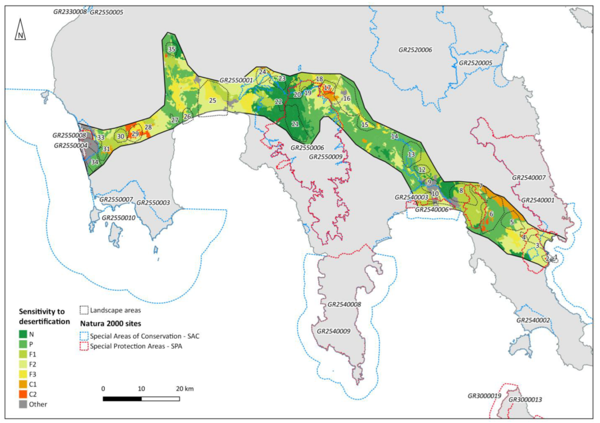
3.5. Sensitivity to Desertification

The results of the application of the ESA index conclude to the following:
(a)
The largest part of the transect area is assessed as in categories that are so-called “sensitive” to desertification; however this scale is a relative gradient scale from “not affected to “critical” levels. (Table 2).
(b)
Critical (level 2) areas are identified in the landscape areas 6, 17 and 29.
(c)
Critical (level 1) areas are identified in the landscape areas 4, 5, 6, 7, 28 and 36.
(d)
Areas not affected by desertification are identified in the landscape areas 20, 21, 22 and 23.
Table 2. Area (%) in a sensitive to desertification category of the ESA index, in the transect area.
ΝPF1F2F3C1C2Other
13%30%17%23%7%3%5%7%
N: not affected, P: potentially affected, F1: sensitive (level 1), F2: sensitive (level 2), F3: sensitive (level 3), C1: critical (level 1), C2: critical (level 2), Other: all other areas. Areas within categories N, P, F1, and F2 are relatively not highly susceptible to desertification changes.
Overall, the relative sensitivity to significant desertification change is minimal in the transect area. Even within the rain-shadow and seasonally semi-arid areas east of the Taygetos range (Evrotas Valley), there are only a few patches rendered in a critical condition (Figure 11); the ESA designates only 8% of the transect area within the critical categories.
A detailed thematic mapping of the ESA index results is presented in Figure 11.

3.6. Vegetation and Fire

The number of days with a high fire risk is an important parameter when considering the effects of climate change on landscapes. Based on different climate change scenarios, it is possible to explore the areas that are vulnerable along the length of the transect. According to the climate change scenarios, for the period 2031–2060 and for the favorable (RCP2.6), intermediate (RCP4.5) and unfavorable scenario (RCP8.5) greenhouse gas emissions (Figure 12a–c, respectively), it was found that following for the change in the number of days with a high fire risk (FWI > 30), compared to the reference period:
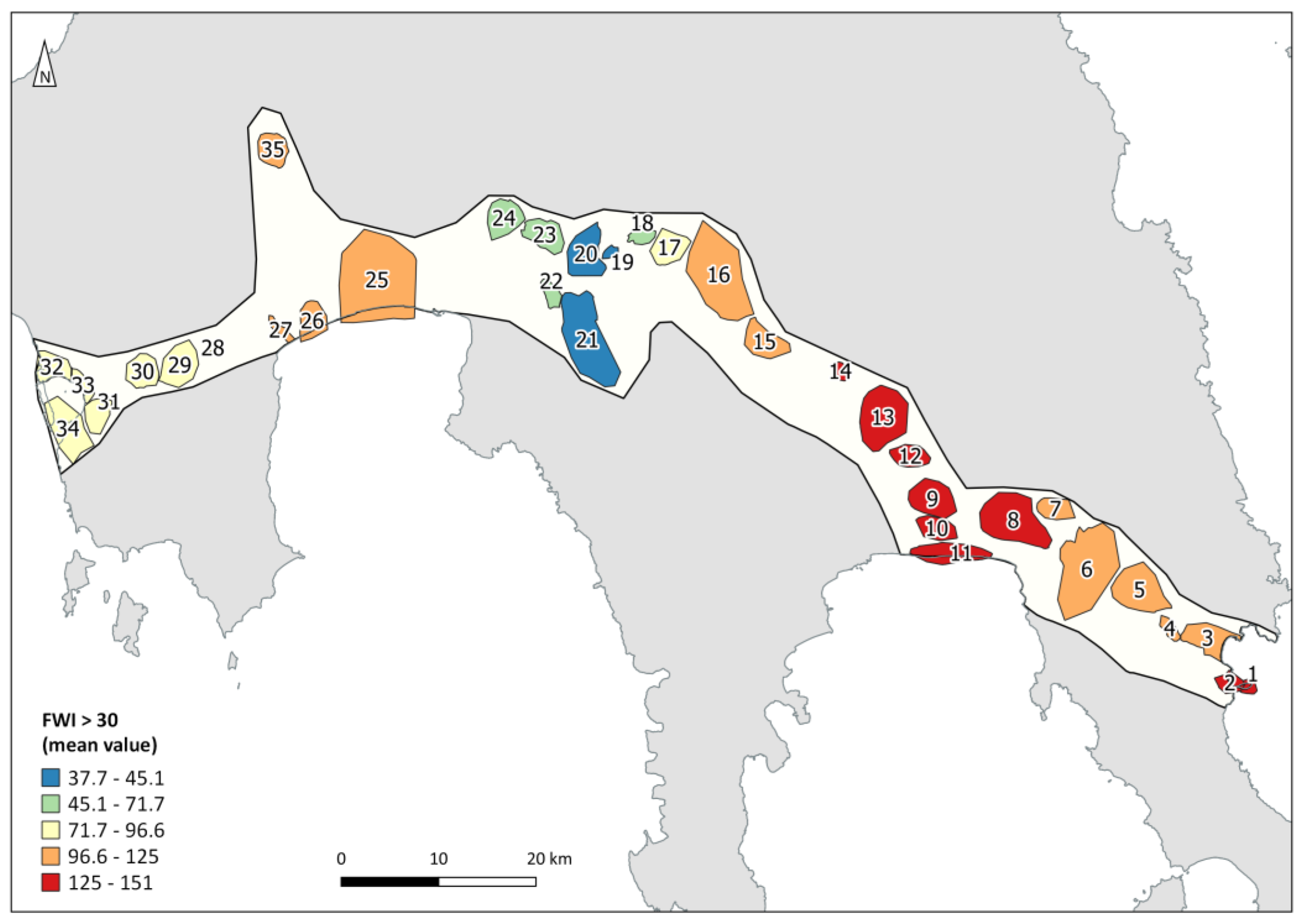
  • In the favorable scenario (RCP2.6), the change will range from 12.7 to 17.2 days. The smallest change (12.7–14 days) is found in the wider area of Pylos (landscape areas 31, 32, 33, 34) at the higher altitudes of Mount Taygetos (parts of landscape areas 18, 19, 20, 21), as well as in the area west of the Evrotas estuary (parts of landscape areas 9, 10, 11). The biggest changes (16–17.2 days) are found in the wider area of Monemvasia (landscape areas 1, 2, 3, 4 (southeast part), 5 (northern part), 6 (northern part) and 7 (most of the area). Intermediate values (14–16 days) prevail for the rest of the cross-sectional areas, as well as the selected landscape areas.
  • In the intermediate scenario (RCP4.5), the range of change in the cross-sectional area is from 11 to 19.4 days. However, the areas where the change is greater than 16 days, increase significantly and thus it is observed that the entire central part of the cross-section is included (landscape areas 15, 16, 17, 18, 19, 20, 21, 22), as well as the entire western section, from the area of Ancient Messene (landscape area 35) to the lake reservoir of Pylos (landscape area 31). The northern, central part is at the maximum of the change (18–19.4 days, landscape areas 24 and 23). The smallest change (11–12 days) is observed in the area of Evrotas and its estuaries (landscape areas 9, 10, 11). For the rest of the cross-sectional areas, as well as the selected landscape areas, intermediate values of changes prevail.
  • In the worst-case scenario (RCP8.5), the change increases significantly across the region and the range of change is from 16 to 23.1 days. The areas with the smallest but at the same time very significant changes are those in the area of the Pamissos River (landscape area 25), Evrota (landscape areas 9, 10, 11) and Pylos (landscape area 34).
Figure 12. Fire changes on the landscape of the future. Difference (average increase) in number of days with a high fire danger (FWI > 30), relative to the reference period (1971–2000), for the transect area, based on different climate change scenarios: (a) 2031–2060, RCP2.6, (b) 2031–2060, RCP4.5, (c) 2031–2060, RCP8.5, (a′) 2071–2100, RCP2.6, (b′) 2071–2100, RCP4.5, (c′) 2071–2100, RCP8.5.
Sustainability 15 13266 g012
According to the climate change scenarios, for the period 2071–2100 and for the favorable (RCP2.6), intermediate (RCP4.5) and unfavorable scenario (RCP8.5) greenhouse gas emissions (Figure 12a′–c′, respectively), the following was found for the change in the number of days with high fire risk (FWI > 30), in relation to the reference period:
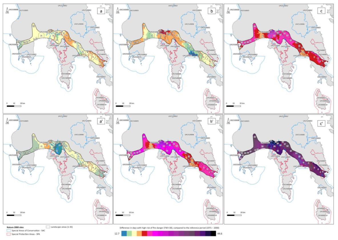
  • In the favorable scenario (RCP2.6), the change will range from 9.37 to 17.93 days. The smallest change (9.37–10 days) is found in the central and southern part of the Taygetos area (landscape area 21) and secondarily in its wider area with a change of 12–14 days (landscape areas 18, 19, 20), as well as in area of Pylos (landscape area 34). The largest changes (16–17.2 days) are found in the wider area of Monemvasia (landscape areas 1, 2, 3, 4 (southeastern part), 5 (northern part), 6 (northern section) and 7 (most of the area). Intermediate values (12–16 days) prevail for the rest of the cross-sectional areas, as well as the selected landscape areas.
  • In the intermediate scenario (RCP4.5), the range of change in cross-sectional area is from 16.43 to 26.75 days. That is, the most favorable conditions in this scenario are at the price of the most unfavorable conditions of the favorable scenario. If we consider the lowest observed range of 16.43–18 as a mere change, this is located in the areas of the two rivers, Pamissos and Evrotas (landscape areas 25 and 9, 10, 11, respectively). The maximum change values (24–26.75 days) are recorded in the central northern and southern parts of the transect and in landscape areas 20 (northern part), 21 (southern part), 23 and 24.
  • In the worst-case scenario (RCP8.5), the change increases significantly across the region and the range of change is from 29.8 to 44.63 days. For this scenario, there is no reason to separate the areas and the landscape areas, since unfavorable fire risk conditions are recorded for the entire section.
Out of the 35 selected landscape areas, eight are those that, according to the FWI index, appear to face the highest fire risk (sites: 1, 2, 8, 9, 10, 11, 12, 13). All these fire-prone areas are located in the xero-thermic rain-shadow east of the Taygetos range, mainly at lower altitudes. On the contrary, three regions are the ones with the lowest values of the index (sites: 19, 20, 21). All three of the above areas are located at high altitudes in the Taygetos mountain range. The remaining landscape areas are in the FWI range of intermediate values (Figure 13).
Summarizing and according to what was presented for the current fire risk conditions, the low lying areas of the Evrotas and Pamissos river valleys have the highest values of the FWI index. In the area of Evrotas, the southernmost part of the valley is covered by intensive crops, which are not considered to be able to fuel a large fire event (e.g., especially not within the water-bearing citrus plantations). In contrast, further north, seasonally semi-arid scrub vegetation prevails, where risk of conflagrations is enhanced and fire can spread relatively easily both in the canyons and ravines of the river and its tributaries as well as in the surrounding plains and hilly areas.

3.7. Delineating and Prioritizing Vulnerable Areas

Through both the bibliographic survey and onsite investigations, a map was created of the areas with an increased concentration of sensitive ecosystems and outstanding landscape values. Delineations were made based on the premises of naturalness, rare ecosystems, biodiversity distinctiveness, protected area values and exceptional cultural landscape elements and features. Eight large landscape conservation priority areal units were delineated within the transect zone; numbered from west to east (Figure 14). It should be made clear that areas that are smaller than the landscape unit (i.e., micro-ecosystems or smaller local biotopes) are not included in this integrated broad-scale prioritization screening. Most of the LAP assessment scores within these eight delineated areas are high (Figure 14), but some degraded landscape sites still host important biodiversity values (species assemblages, habitat areas) (sites 1, 3, 6 and 7 in Figure 14). Coastal wetlands have been particularly degraded in terms of the overall landscape condition, but the larger wetland areas highlighted here support regionally scarce and biodiversity-rich aquatic and riparian ecosystems; in some cases, with important potential for conservation and restoration initiatives both at the local ecosystem scale and the landscape scale. An environmentally degraded but outstanding wetland area is the Pamissos Delta (site 3 in Figure 14) which unfortunately has not been recognized as a Natura 2000 protected area despite holding important ecological values and being listed within the former EU Corine Biotopes project ([55] NTUA 2010). This kind of broad-scale analysis and mapping should be open to local discussion and the scrutiny of stakeholders and the local communities.

4. Discussion

4.1. Surveying with a Landscape Transect Method

To the best of our knowledge, the landscape transect method was piloted for the first time within a policy-relevant climate change adaptation in this study (see: [46]). Our bibliographic review of this topic shows that there are still substantial gaps in applying landscape assessment approaches within a climate change adaptation context. The landscape transect method we have developed uses a rapid assessment procedure based on the principles of bioassessment within a landscape ecology framework coupled by climate scenario and selected indicator analyses. By utilizing both the territorial (areal) and perceptual (scenic) aspects of the landscape, as promoted by Antrop and Eetvelde in 2019 [1], it attempts a holistic landscape-centered synthesis within a rapid screening study. A novelty and special initiative of our method is the three-pronged spatial scale of analysis involving: (a) a transect zone (regional scale), (b) a landscape area unit and (c) an on-site landscape view assessment. This promotes a multi-faceted analysis that attempts to be comprehensive and representative with concern for landscape conservation planning within a designated study area. This is proven by the fact that within the study transect, all six landscape types were sampled, and the 35 selected landscape areal units/viewpoints cover a high percentage of the transect zone. Our study provides evidence that this is possible at minimal cost, including a short-term field visit, a restricted data collection period and straightforward analyses with the support of a small number of experts.
The landscape transect approach applied here can collect, review and systematize a substantial amount of policy-relevant information. As in all rapid assessment applications, time and costs must be minimalized. In this application, the field research was limited to five days (with the participation of two experienced researchers), using simple and widespread recording technologies (cameras, binoculars, a drone).
The transect method development shows that this kind of landscape “sampling” could be a useful review process in climate adaptation procedures, such as the RAAPs, by setting knowledge baselines and promoting holistic integrative reviews. Although the transect application itself does not include public involvement processes, Greece’s draft RAAPs will be subject to public consultation and to an opinion-giving procedure by the existing Regional Consultation Committees, consisting of municipalities, regional representatives of the government authorities, regional stakeholders and citizens’ representatives. Draft RAAPs in Greece have shown an effort to focus on specific measures, and these should evolve to include wider changes and new challenges [42].
Our presentation of this pilot study and our critique of the methodology and experience of its application may provide useful insights, especially within regions or states where landscape conservation has been sorely neglected. In fact, the Region of the Peloponnese does not even have a basic inventory of landscape areas or landscape classification scheme; i.e., such as a landscape character area delineation and many of its protected areas are poorly researched for their landscape values [16,39]. Rapid assessment methods can be most useful in areas of such data scarcity and especially where there is no foundation to support landscape-scale sensitivity analyses [61,62]. Landscape issues have important gaps in conservation in Greece due particularly to historical, cultural and socio-economic reasons [38,63]. Several publications have documented that landscape-scale conservation is very poorly addressed in Greece (e.g., [64,65,66,67]). Our review of the RAAP for the Peloponnese confirms a distinct lack of reference to measurable conservation applications concerning landscape features and landscape conservation planning, in particular.
Below, we address specific aspects of the methodological application, we highlight the main environmental problems perceived through the study and provide some recommendations gained through this application.

4.2. The Transect Zone (Study Area)

The idea of applying a wider transect zone instead of a line or thin linear band has been applied here, as in other applications of regional-scale transect studies (e.g., [54]). Since we are considering landscape spatial units, it is a simple premise to keep the transect study area wide enough to include a variety of representative landscapes. We add that the width and orientation of the transect study area cannot be a totally straight linear feature, it should include deviations to include landscapes of outstanding heritage interest and other landscape areas representative of the region being studied. In our case, the western part of the transect bulges northwards to include Ancient Messene, an archeological area of outstanding significance where climate change projections have been recently investigated [68]. Focusing on the fact that a transect is a representative and selected “sampling” of landscapes, we consider it proper to include a variety of landscape types present in the wider region. In this sense, the transect area is not a randomly nor arbitrarily defined line, it is a selected limited-area zonal sample that includes a gradient of different landscape types slicing through the study region.
The extremely useful aspect of the broad zonal transect approach concerns the application of the scenario models and indicators for the overview of specific impacts at the local landscape level. Because the linear transect zone crosses several different climate zones, this exercise classifies and compares the conditions and possible effects of climate change in different bioclimatic zones and varied landscape conditions. As a result, maps are instructive and attractive because of the comparative dimension. The cartography is especially useful for analysis at the landscape scale (area units within the transect zone) and for interpreting spatial patterns related to climate or global change [46].

4.3. Landscape Areas (Areal Units)

The concept of “landscape area” does not have a specific standardized method for delineation; there are many different approaches and practical methods [2,6]. In our case, the approach may vaguely resemble the demarcation of landscape character areas which has a “hierarchical” delimitation process. In fact, the landscape character areas in their most local forms do delineate fairly narrow-scale landscape units in a similar fashion to the present transect study (see: [2]). However, our areal units are “samples” of landscape areas. Along the 240 km transect, it was estimated that roughly 35 representative “sample landscapes” would be adequate and practicable for on-site survey during a restricted time frame. The use of a drone as well as remote sensing from open archives (Google Earth, with 3D terrain visualizations) helped in the final delineations. Also, the landscape areas are very close to one another, arranged along a sequence in the transect (from east to west). The size of each landscape area necessarily differs greatly in relation to the relief and the features that define the spatial unity of each landscape unit.
The evaluation and description of the landscape areas employed a simple procedure documented within a draft field protocol. The “ELLET landscape protocol” (see: [59]) was created as a descriptive protocol providing checklists and categories for evaluation. It is a multi-sectoral protocol that helps evaluate the landscape area based on the on-site viewpoints and other research through assessing four dimensions of the landscape (ecological, economic, social/cultural and perceptual). The procedure attempts both quantitative and qualitative survey approaches as is often the case in landscape character assessment (LCA) [69]. The quantification of evaluations in the newly piloted protocol was especially difficult to standardize, and the approach was attempted with selected indicators and a simple point scoring scale (5 = excellent to 0 = degraded). The protocol concerns the assessment in the scope of the landscape area and is completed in the field with evidence-based corrections and reinforcement from the bibliography in a second analysis (after the field visit). While the protocol has borrowed elements from LCA (i.e., [62]), we reiterate this application is not an LCA process but a sampling using some LCA criteria among others.

4.4. Landscape Viewpoints (LAP Assessment)

Landscape visual evaluation provides an anthropocentric approach to landscape analysis and evaluation is concerned with how humans perceive and feel in a landscape area, specifically in the landscape’s view [17,70,71]. In this regard, specific viewpoints within the delineated landscape areas were identified which offer representative views of the landscape, and these views were assessed using a standard protocol. Evaluation utilized the landscape assessment protocol [17], which has been used under various assessment frameworks in recent years [72]. The visual assessment is a critical part of the field survey and the scoring of the fifteen metrics provided by LAP can be used independently (i.e., aesthetic attractiveness), in combinations or as a final index. It is obvious to the authors that this line of study will develop rapidly in the near future; many new techniques have recently been published [72,73,74].

4.5. Landscape Typology

In order to build an initial classification of landscapes, climate-relevant elevations and land-cover forms provided criteria for a landscape typology map. This was a difficult undertaking and should be performed with extreme care and review. Such a typological map is sensitive to the selected criteria and specific cut-offs (i.e., elevation thresholds). Although several land-cover and topographical combinations produced other classification configurations, the authors finally decided on a basic map of six landscape types. Criteria for including mapping categories were therefore expert based. For example, some handpicked landscape-relevant features on the map such as build-up areas and the coastal large-wetlands were included (Figure 6). Within such a small and heterogeneous area, there is no ideal classification of landscape types which would combine key parameters to create an objective typological map [75,76]. In any typology, there will be compromises that may bring up disagreements over boundary options [77]. Perhaps a simplified map, such as the one presented here, may assist communication and conservation priorities ([78]). However, the typology map is solely a draft preliminary exhibit. To quote Alfred Korzybski’s dictum: The “map is not the territory”; we should not confuse models of reality (maps) with the complexity of reality itself.

4.6. Projections Using Data and Models

The definition of the broad (wide zonal) transect area was helpful in researching projections of climate change scenarios and in the analysis of climatic effects on many bioclimatic conditions and land uses [79,80]. A broader transect area also spatially depicts impacts such as major firestorms, which often cover many tens of square kilometers in area. As confirmed by recent analyses, the results show that fire danger is expected to progressively increase in the future, especially in the high-end climate change scenario, with southern and eastern regions of Greece, such as the study area, being most at risk (Rovithakis et al. 2022 [81]). Also, this transect setup provides an opportunity to discuss the influence from climate change scenarios on specific areas, since they are not a constant in IPCC reports. It was obviously the right choice to provide a wide zone instead of the thin linear form in the context of the development of the application of the landscape transect method.

4.7. Challanges and Limitations

As in some other landscape transect approaches in recent years [82], the transect approach for landscape research is used as a screening-level method with inherent subjectivity. In some contexts, these may not be seen as shortcomings or weaknesses but as important general approaches initiating holistic research on landscapes [46]. However, in using a mixed-methods protocol for rapid assessment, efforts must be made to standardize and streamline the practice.
Some challenges and insights the authors identified in applying the landscape transect method in this case study include the following:
(a)
Transect selection techniques rely on the configuration and extent of the transect zone; they must be clearly defined and substantiated through the research rationale. In this current study, the transect location was initially described within a major EU-funded research project (LIFE-IP AdaptInGR) with specific policy-relevant aims.
(b)
Identifying landscape areal units within the transect and accompanying viewpoints is prone to subjectivity that cannot be easily surpassed.
(c)
The transect is a sampling method not a concrete systematic organization of landscape units. In this, it differs from other initiatives, such as landscape character assessment, as being an exploratory method instead of systematic delineation framework.
(d)
Each delineation (landscape area and/or viewpoint) depends on the viewpoint and access point of the landscape. For this reason, these landscape areas are sample areas of the landscapes of the wider transect and of course often intersected by a central access road. As such, it is not easy to have absolute representativeness, especially in topographically heterogeneous areas.
(e)
The number of delineated landscape areas and viewpoints may seem arbitrary. In terms of areas and viewpoints, the “more the better” is a useful rule of thumb.
(f)
Assessing vulnerability depends both on data and the experience of the expert assessors involved in the research and analysis. Initial landscape typologies and mapping areas of outstanding interest stand as preliminary screening-level applications that may require further future verification.
The transect must traverse a region, be it an ecoregional unit or administrative region, such as in our case. A variety of contrasting conditions and landscapes must be included in the “landscape samples” in order to define interpretable patterns. “Designing” at the landscape spatial scale requires local knowledge of landscape patterns and processes [83]. When time is limited or horizon screening is required, it may be proper to limit the areal coverage to a transect. Some of the interpretations may be difficult to make; for example, land abandonment may have both beneficial as well as negative effects on landscape stability and biodiversity conservation [84]. In this way, the transect study becomes an educational and heuristic research tool.
Finally, our work may be useful as a precursor for a wider application with stakeholder involvement in climate adaptation frameworks’ planning and implementation stages. Many methods have recently been developed to increase involvement and engage local populations in landscape literacy [85], including collaborative landscape approaches [86]. Public participation is crucial to the success of any landscape planning endeavor, especially where comprehensive conservation action plans must be planned and implemented. While it is important to review changes to land use/land cover in order to identify the underlying drivers and effectiveness of landscape management [87], the rapid screening of samples of the landscape also provides a simple holistic multi-level approach.

4.8. Insights and Recommendations

Our analysis provides evidence of serious future problems related to the conservation of landscapes throughout most of the study region. The problems are closely connected to local land-use change, various modern human pressures and the region’s climatic variability (i.e., propensity for extreme drought events) and the threats of future climate change [88,89]. The eastern Peloponnese, a rain shadow area, is projected to experience some of the strongest declines in precipitation in Greece. However, although this region may be seen as a climate change hotspot, it may have inherent resilience due to its naturally seasonally semi-arid climatic conditions. Contrary to what may be expected by many lay people this area is not immediately threatened by desertification or extreme soil erosion problems. This point has been expressed by earlier landscape researchers as well [90,91].
Major landscape-scale problems relate to poor land-use planning and conservation management and enforcement problems as seen in other areas in southern Greece. Interestingly, although our focus was not on urban areas, the problem of urban and peri-urban sprawl was evident in many lowland landscapes, especially near the coasts and around major towns. This is a priority challenge in the Mediterranean [92], and it may be said that the problem and threat to the landscape has developed to notorious proportions in Greece [64,67]. Limiting suburbanization and discontinuous urban sprawl are priority issues related to boosting the adaptive capacity of the wider cultural landscape [64,93].
Forest landscape patterns are changing. Upland agropastoral abandonment has brought wholesale land-use change, an issue widely observed in Greece and other northern Mediterranean countries in recent decades (e.g., [94]). Although the “greenery” has flourished in the form of thicket-like scrublands and woodland the threat of forest fires has also increased. Altered disturbance regimes by fire radically change the landscape structure [95,96]. Anthropogenically altered species compositions in current forests, coupled with fire suppression over the past 50 years, will lead to a massive increase in fire frequency [81]. This may lead to landscapes that are quite different from current ones, with natural older forests becoming very scarce.
Intensification of certain crops and water stress in the lowlands is a serious and complicated pressure, and this has also been analyzed specifically in other studies in our study area (e.g., [97,98]). The expansion and intensification of olive groves and olive oil production changes landscapes [99]. In our study area, these cash-crop plantations also produce seasonally toxic olive mill wastewater discharge in hundreds of streams and rivers [100]. The authors observed new mono-cultures of irrigated olive plantations in many areas. Both the homogenization of the landscape character and the decline of certain “special habitats” contribute to biodiversity impoverishment.
Biodiversity plays a crucial role in sustainable agriculture, socio-economic development, cultural ecosystem services and in overall ecological integrity [75,101]). The Mediterranean’s exceptional diversity of freshwater fauna faces a crisis in which climate change combined with the overexploitation of freshwater environments threatens biodiversity (e.g., [102]). Studies in our region point to such pressures and threats, especially through the widespread degradation of wetlands [103] and streams [88]. Mediterranean wildlife such as birds and reptiles have demonstrably been proven to decline through the sprawl of tourism-related buildings and roads [104]. These are indicators of the widespread negative effect of poorly enforced land management.
Problems with “changing landscapes” and “degraded landscapes” under climate change include the potential for future societal conflicts. Mitigating the risks of conflict among such important issues involving water management, building sprawl and nature conservation is critical in our study region. In this context, it is urgent and important to objectively define conservation priorities and strategize at the landscape scale (i.e., not just within designated protected areas). A regional framework for landscape planning is required, especially in attempts to prioritize conservation actions and rectify serious drivers of degradation, such as unchecked holiday home sprawl and poorly planned industrial developments, which even includes newly proposed dams and wind farms [40,64]. Also, within the planning framework, consideration must be given to support proposals for restoration at the landscape scale [33,105]. Restoration approaches, including the ecological restoration of stressed ecosystems, needs to be proactive instead of reactive [75]. Greece, along with some other Mediterranean countries, has minimal in-country experience in ecological restoration, even concerning such threatened ecosystems as its freshwater wetlands [106]. Many precious wetland areas are immediately threatened or very degraded in our study area; places such as the Pamissos and Evrotas river deltas need immediate attention and for restoration initiatives to be applied at the landscape scale.
In view of our investigation’s local insights, the priority steps that should be taken include the following:
(a)
Inventory and landscape mapping to integrate issues of landscape within climate change adaptation at the regional scale (i.e., within the entire region of the Peloponnese);
(b)
A focus on protecting landscape areas within the framework of formal protected areas that should include culturally important features of the landscape as well as the country’s protected-area system (i.e., both inside and outside the designated Natura 2000 sites);
(c)
Special efforts for forest and rangeland management to manage wildfire and affect the homogenizing effect of fire-prone scrubland spread due to mass agro-pastoral abandonment;
(d)
Special efforts for water and water-dependent biodiversity conservation, including restoration initiatives in rivers, particularly river deltas that include flood-prone zones;
(e)
Peri-urban and coastal sprawl problems and enforcement of all laws and protected area zoning;
(f)
Incorporating locally perceived landscape values and promoting landscape literacy in the local population.
The policy-relevance of our work should be obvious if one appreciates the European Landscape Convention and the general requirements for planning with landscape and climate change adaption in mind [107,108]. With the ratification of the convention, each European State commits itself to develop and implement specific initiatives that areaimed at policy implemented towards landscape conservation, management and planning. Planning at the landscape scale is a complex dynamic between different types of contextual and codified knowledge and institutional and public participants with political and socioeconomic consequences [34]. To quote Grove and Rackham [90], landscape conservation practice is where “…aesthetics, land economy and ecological well-being overlap”.
The ways humans relate to landscape systems will be influenced by the degree of appreciation for the qualities and conditions of local landscapes. Landscape assessments can be practiced at various levels of depth and the transect method is at least one method for promoting landscape literacy and societal involvement. Furthermore, these integrative research approaches are especially important in the more complex cultural landscapes where cultural heritage should be carefully inventoried and managed [31]. The vulnerabilities often point to novel priorities, such as fire history investigations [109] and fire-smart forest management initiatives that have been long neglected [110]. Finally, it should be said that in recent years there have been many innovative solutions towards promoting more sustainable agriculture practices, such as in olive cultivation [111] and adaptation that can be coupled with agrometeorological understanding [112]. The landscape transect method may act as a promotional tool. It may assist in public awareness and local engagement by setting an “enabling framework” for landscape-scale conservation promotion during the climate change adaptation process.

5. Conclusions

This study’s objectives include building and initiating a landscape transect method for rapidly assessing landscapes in three distinct spatial scales of analysis to investigate risks due to the projected effects of climate change within a region. Efforts were undertaken to create a practical and fast-paced mixed methods procedure; this type of work has rarely been published for application within a climate change adaptation context. This work may have educational and heuristic value and could be of interest for further development since it aims to help bridge the disconnect between the policy-relevant adaptation measures and the requirements to apply landscape conservation within the climate change context.

Author Contributions

Conceptualization, V.V., M.L. and T.D.; methodology, V.V., T.D. and M.L.; formal analysis, V.V., I.C. and I.P.K.; investigation V.V., I.C. and I.P.K.; data curation, I.C., C.G. and I.P.K. writing—original draft preparation, V.V., I.C. and I.P.K.; writing—review and editing, V.V., I.P.K., I.C., T.D. and M.L.; visualization, T.D., V.V., I.C. and I.P.K.; supervision, T.D. and M.L.; project administration, M.L.; funding acquisition, M.L. All authors have read and agreed to the published version of the manuscript.

Funding

This study was conducted by the ELLINIKI ETAIRIA Society for the Environment and Cultural Heritage under the project “LIFE-IP AdaptInGR–Boosting the implementation of adaptation policy across Greece LIFE17 IPC/GR/000006”, deliverable “Sub-Action C.4.D.1: Development of pilot assessments and adaptation guidelines for landscapes and land-uses. Case Study: Landscape and Land Uses, The Transect method from Pylos to Monemvasia with the contribution of the LIFE Programme of the European Union and of the Green Fund-Hellenic Ministry of Environment and Energy.

Institutional Review Board Statement

“Not applicable” for studies not involving humans or animals.

Informed Consent Statement

“Not applicable.” for studies not involving humans.

Data Availability Statement

Data is curated by ELLINIKI ETAIRIA-Society for the Environment and Cultural Heritage and the relevant report is available upon request.

Acknowledgments

This study was conducted by under the project “LIFE-IP AdaptInGR–Boosting the implementation of adaptation policy across Greece LIFE17 IPC/GR/000006”, deliverable “C4.1 Deliverable C4.D1 with the contribution of the LIFE Programme of the European Union and of the Green Fund. We thank OPEKEPE—the Greek Payment Authority of Common Agricultural Policy (C.A.P.)—for providing us data about agriculture and livestock grazing. We acknowledge the assistance of Giannis Lemesios (NOA) and Dyonisia Liveri (Doxiadis+) and all members of ELLINIKI ETAIRIA-Society for Environment and Cultural Heritage who also provided assistance during the study in 2021. We thank the four reviewers for constructive comments and S. Zogaris for English language editing.

Conflicts of Interest

The authors declare no conflict of interest.

Appendix A

Table A1. Outline of any mention of the word “landscape” within the Regional Adaptation Action Plan (RAAP) of the Peloponnese [60]. To the best of the author’s knowledge, the context of the reference to landscape is noted and a three-class scoring of the reference applicable landscape conservation measures promoted in the RAAP. Scoring with respect to applicability to landscape conservation, accounted as such: Low = minimal, simple wording or informal account of the word “landscape”; Moderate = general reference to landscape conservation applicability; High = practical reference, i.e., promoted and specific measures for conservation and/or restoration of landscape.
PageContextApplicable to Conservation
163Reference to landscapes of outstanding natural beauty.Low
263List of landscapes of outstanding natural beauty.Moderate
366List of protected traditional settlements.Moderate
467“Pollution” issues with a phrase referring to “wider landscape”, not specific to landscape itself.Low
567Lignite mining degrading landscape.Moderate
667Lignite mining degrading landscape. Moderate
7165General reference to protected areas.Low
8165General reference to wilderness landscape.Low
9165General reference to agricultural landscape.Low
10190General reference to farming of currant raisin landscape.Low
11191General reference transhumance livestock grazing and landscape.Low
12201Reference to the “General Land-Use Framework” law (ΦΕΚ 128/A/2008), which includes as one of its aims the protection of the landscape.Moderate
13202Policy-relevant landscape conservation, especially with respect for peri-urban sprawl.Moderate
14272General reference to landscape degradation caused by wildfires.Low
15455General reference to indirect effects of climate change on the “natural landscape” including coastal erosion and habitat degradation.Low
16506Reference to landscape rehabilitation of lignite mining.High
17565Specific reference to the degradation caused by disease to forests and vegetation including invasive species. Monitoring and surveillance promoted as solutions.High

References

  1. Antrop, M.; Van Eetvelde, V. Territory and/or Scenery: Concepts and Prospects of Western Landscape Research. In Current Trends in Landscape Research; Mueller, L., Eulenstein, F., Eds.; Springer: Müncheberg/Brandenburg, Germany, 2019; pp. 3–39. [Google Scholar]
  2. Warnock, S.; Griffiths, G. Landscape characterization: The living landscapes approach in the UK. Landsc. Res. 2015, 40, 261–278. [Google Scholar] [CrossRef]
  3. Zube, E.H. Themes in landscape assessment theory. Landsc. J. 1984, 3, 104–110. [Google Scholar] [CrossRef]
  4. Smardon, R. Ecosystem services for scenic quality landscape management: A review. Land 2021, 10, 1123. [Google Scholar] [CrossRef]
  5. Angelstam, P.; Munoz-Rojas, J.; Pinto-Correia, T. Landscape concepts and approaches foster learning about ecosystem services. Landsc. Ecol. 2019, 34, 1445–1460. [Google Scholar] [CrossRef]
  6. Opdam, P.; Wascher, D. Climate change meets habitat fragmentation: Linking landscape and biogeographical scale levels in research and conservation. Biol. Conserv. 2004, 117, 285–297. [Google Scholar] [CrossRef]
  7. Zhang, S. Knowledge Mapping Analysis of the Study of Ecosystem Services and Landscape Architecture. Ph.D. Dissertation, American Society of Civil Engineers, Reston, VA, USA, 2022. [Google Scholar]
  8. Sheppard, S.R. Making climate change visible: A critical role for landscape professionals. Landsc. Urban Plan. 2015, 142, 95–105. [Google Scholar] [CrossRef]
  9. Lin, Y.P.; Chen, C.J.; Lien, W.Y.; Chang, W.H.; Petway, J.R.; Chiang, L.C. Landscape conservation planning to sustain ecosystem services under climate change. Sustainability 2019, 11, 1393. [Google Scholar] [CrossRef]
  10. Land Use Consultants. An Assessment of the Impacts of Climate Change on Scottish Landscapes and Their Contribution to Quality of Life: Phase 1—Final Report; Scottish Natural Heritage Commissioned Report No. 488; Scottish Natural Heritage: Inverness, UK, 2011. [Google Scholar]
  11. Raymond, C.M.; Brown, G. Assessing spatial associations between perceptions of landscape value and climate change risk for use in climate change planning. Clim. Change 2011, 104, 653–678. [Google Scholar] [CrossRef]
  12. Bizikova, L.; Crawford, E.; Nijnik, M.; Swart, R. Climate change adaptation planning in agriculture: Processes, experiences and lessons learned from early adapters. Mitig. Adapt. Strat. Glob. Change 2014, 19, 411–430. [Google Scholar] [CrossRef]
  13. Köpsel, V.; Walsh, C.; Leyshon, C. Landscape narratives in practice: Implications for climate change adaptation. Geogr. J. 2017, 183, 175–186. [Google Scholar] [CrossRef]
  14. Froese, R.; Schilling, J. The Nexus of Climate Change, Land Use, and Conflicts. Curr. Clim. Change Rep. 2019, 5, 24–35. [Google Scholar] [CrossRef]
  15. Solecka, I. The use of landscape value assessment in spatial planning and sustainable land management—A review. Landsc. Res. 2019, 44, 966–981. [Google Scholar] [CrossRef]
  16. Kokkoris, I.P.; Mallinis, G.; Bekri, E.; Vlami, V.; Zogaris, S.; Chrysafis, I.; Mitsopoulos, I.; Dimopoulos, P. National Set of MAES Indicators in Greece: Ecosystem Services and Management Implications. Forests 2020, 11, 595. [Google Scholar] [CrossRef]
  17. Vlami, V.; Zogaris, S.; Djuma, H.; Kokkoris, I.P.; Kehayias, G.; Dimopoulos, P. A field method for landscape conservation surveying: The landscape assessment protocol (LAP). Sustainability 2019, 11, 2019. [Google Scholar] [CrossRef]
  18. Zhou, T.; Ren, W.; Peng, S.; Liang, L.L.; Ren, S.; Wu, J. A riverscape transect approach to studying and restoring river systems: A case study from southern China. Ecol. Eng. 2014, 65, 147–158. [Google Scholar] [CrossRef]
  19. Zhang, Z.; Tu, Y.J.; Li, X. Quantifying the spatiotemporal patterns of urbanization along urban-rural gradient with a roadscape transect approach: A case study in Shanghai, China. Sustainability 2016, 8, 862. [Google Scholar] [CrossRef]
  20. Kizos, T.; Verburg, P.; Bürgi, M.; Gounaridis, D.; Plieninger, T.; Bieling, C.; Balatsos, T. From concepts to practice: Combining different approaches to understand drivers of landscape change. Ecol. Soc. 2018, 23, 25. [Google Scholar] [CrossRef]
  21. Allen, T.F.H.; Hoekstra, T.W. Toward a Definition of Sustainability. In Sustainable Ecological Systems: Implementing an Ecological Approach to Land Management; Rocky Mountain Forest and Range Experiment Station: Fort Collins, CO, USA, 1994; pp. 98–107. [Google Scholar]
  22. Thompson, I.D.; Flannigan, M.D.; Wotton, B.M.; Suffling, R. The effects of climate change on landscape diversity: An example in Ontario forests. Environ. Monit. Assess. 1998, 49, 213–233. [Google Scholar] [CrossRef]
  23. Kail, J.; Januschke, K.; Hering, D. Freshwater-related species richness in Natura 2000 sites strongly depends on the surrounding land use besides local habitat conditions. J. Environ. Manag. 2023, 340, 118025. [Google Scholar] [CrossRef]
  24. Maltby, E. The Wetlands Paradigm Shift in Response to Changing Societal Priorities: A Reflective Review. Land 2022, 11, 1526. [Google Scholar] [CrossRef]
  25. Melnick, R.Z.; Kerr, N.P.; Malinay, V.; Burry-Trice, O. Climate Change and Cultural Landscapes: A Guide to Research, Planning, and Stewardship. Cultural Landscape Guidance Documents; Cultural Landscape Research Group, Department of Landscape Architecture, University of Oregon: Eugene, OR, USA, 2017; p. 59. [Google Scholar]
  26. Galan, J.; Galiana, F.; Kotze, D.J.; Lynch, K.; Torreggiani, D.; Pedroli, B. Landscape adaptation to climate change: Local networks, social learning and co-creation processes for adaptive planning. Glob. Environ. Change 2023, 78, 102627. [Google Scholar]
  27. Glick, P.; Stein, B.A.; Edelson, N.A. Scanning the Conservation Horizon: A Guide to Climate Change Vulnerability Assessment; National Wildlife Federation: Washington, DC, USA, 2011; p. 168. [Google Scholar]
  28. Yousefpour, R.; Jacobsen, J.B.; Thorsen, B.J.; Meilby, H.; Hanewinkel, M.; Oehler, K.A. Review of decision-making approaches to handle uncertainty and risk in adaptive forest management under climate change. Ann. For. Sci. 2011, 69, 1–15. [Google Scholar]
  29. Biesbroek, G.R.; Swart, R.J.; Carter, T.R.; Cowan, C.; Henrichs, T.; Mela, H.; Morecroft, M.D.; Rey, D. Europe adapts to climate change: Comparing national adaptation strategies. Glob. Environ. Change 2010, 20, 440–450. [Google Scholar]
  30. Bürgi, M.; Celio, E.; Diogo, V.; Hersperger, A.M.; Kizos, T.; Lieskovsky, J.; Pazur, R.; Plieninger, T.; Prishchepov, A.V.; Verburg, P.H. Advancing the study of driving forces of landscape change. J. Land Use Sci. 2022, 17, 540–555. [Google Scholar]
  31. Cook, I.; Johnston, R.; Selby, K. Climate change and cultural heritage: A landscape vulnerability framework. J. Isl. Coast. Archaeol. 2021, 16, 553–571. [Google Scholar]
  32. Council of Europe. Council of Europe Landscape Convention Website. 2000. Available online: https://www.coe.int/en/web/conventions/full-list?module=treaty-detail&treatynum=176 (accessed on 2 April 2023).
  33. Stanturf, J.A. Future landscapes: Opportunities and challenges. New For. 2015, 46, 615–644. [Google Scholar]
  34. Marson, A. Landscape in Spatial Planning: Some Evidence on Methodological Issues and Political Challenges. Land 2023, 12, 827. [Google Scholar]
  35. Tsilimigkas, G.; Kizos, T. Space, pressures and the management of the Greek landscape. Geogr. Ann. Ser. B Hum. Geogr. 2014, 96, 159–175. [Google Scholar]
  36. Kyvelou, S.S.; Gourgiotis, A. Landscape as connecting link of nature and culture: Spatial planning policy implications in Greece. Urban Sci. 2019, 3, 81. [Google Scholar]
  37. Pavlis, E.; Terkenli, T. Landscape values and the question of cultural sustainability: Exploring an uncomfortable relationship in the case of Greece. Nor. Geogr. Tidsskr. 2017, 71, 168–188. [Google Scholar]
  38. Terkenli, T.S. Landscape and justice: The case of Greeks, space and law. Landsc. Res. 2022, 47, 797–810. [Google Scholar]
  39. Vlami, V.; Kokkoris, I.P.; Zogaris, S.; Cartalis, C.; Kehayias, G.; Dimopoulos, P. Cultural landscapes and attributes of “culturalness” in protected areas: An exploratory assessment in Greece. Sci. Total Environ. 2017, 595, 229–243. [Google Scholar] [PubMed]
  40. Vlami, V.; Kokkoris, I.P.; Zogaris, S.; Kehayias, G.; Dimopoulos, P. Cultural ecosystem services in the Natura 2000 network: Introducing proxy indicators and conflict risk in Greece. Land 2020, 10, 4. [Google Scholar]
  41. Pediaditi, K.; Moquay, P. Landscape injustices in polarised communities: Unearthing perceptions at Sitia UNESCO Geopark, Greece. Landsc. Res. 2022, 47, 767–782. [Google Scholar]
  42. Lazoglou, M.; Serraos, K. Climate change adaptation through spatial planning: The case study of the region of Western Macedonia. In IOP Conference Series: Earth and Environmental Science; IOP Publishing: Bristol, UK, 2021; Volume 899, p. 012021. [Google Scholar]
  43. Trovato, M.G.; Ali, D. Planning tools for the protection of the natural and cultural heritage in the Eastern Mediterranean area. In Current Trends in Landscape Research; Mueller, L., Eulenstein, F., Eds.; Leibniz Centre for Agricultural Landscape Research (ZALF): Müncheberg/Brandenburg, Germany, 2019; pp. 467–486. [Google Scholar]
  44. Imeson, A.C.; Lavee, H. Soil erosion and climate change: The transect approach and the influence of scale. Geomorphology 1998, 23, 219–227. [Google Scholar]
  45. Braae, E.; Diedrich, L.; Lee, G. The travelling transect: Capturing island dynamics, relationships and atmospheres in the water landscapes of the Canaries. In Proceedings of the Nordic Design Research Conference, Malmö, Sweden, 9–12 June 2013; pp. 191–200. Available online: www.nordes.org (accessed on 13 January 2021).
  46. Han, S. The use of transects for resilient design: Core theories and contemporary projects. Landsc. Ecol. 2021, 36, 1567–1582. [Google Scholar]
  47. Medley, K.E.; McDonnell, M.J.; Pickett, S.T. Forest-landscape structure along an urban-to-rural gradient. Prof. Geogr. 1995, 47, 159–168. [Google Scholar]
  48. Diedrich, L.; Lee, G.; Braae, E. The Transect as a Method for Mapping and Narrating Water Landscapes: Humboldt’s Open Works and Transareal Travelling; NANO New American Notes Online: New York, NY, USA, 2014. [Google Scholar]
  49. Duany, A.; Talen, E. Transect Planning. J. Am. Plann. Assoc. 2002, 68, 245–266. [Google Scholar] [CrossRef]
  50. Francis, C.; Morse, S.; Breland, T.A.; Lieblein, G. Transect walks across farms and landscapes. NACTA J. 2012, 56, 92–94. [Google Scholar]
  51. Parker, C.; Owens, P.E. A line through a City: Using transects to uncover patterns, experiences and histories of everyday landscapes. In Routledge Handbook of Urban Landscape Research, 1st ed.; Routledge: Oxfordshire, UK, 2022; ISBN 9781003109563. [Google Scholar]
  52. Steiner, F.R.; Thompson, G.F.; Carbonell, A. Nature and Cities: The Ecological Imperative in Urban Design and Planning; Lincoln Institute of Land Policy: Cambridge, MA, USA, 2016. [Google Scholar]
  53. Guan, B.; Gao, J.; Chen, W.; Gong, X.; Ge, G. The Effects of Climate Change on Landscape Connectivity and Genetic Clusters in a Small Subtropical and Warm-Temperate Tree. Front. Plant Sci. 2021, 12, 671336. [Google Scholar]
  54. Koch, G.W.; Vitousek, P.M.; Steffen, W.L.; Walker, B.H. Terrestrial transects for global change research. Vegetatio 1995, 121, 53–65. [Google Scholar]
  55. NTUA (National Technical University of Athens). Filotis Database for Greek Nature. 2010. Available online: https://filotis.itia.ntua.gr/ (accessed on 8 October 2021).
  56. Gavriilidou, E.; Tzamou, C.; Pougakioti, V. Database Documenting M and E Methodologies and Indicators Pertinent to Adaptation Actions Covering All Vulnerable Sector: Landscape/Land-Uses; LIFE-IP AdaptInGR–Boosting the Implementation of Adaptation Policy Across Greece LIFE17 IPC/GR/000006” Deliverable “Sub-Action A2.D2; ELLET (Elliniki Etairia—Society for the Environment and Cultural Heritage): Athens, Greece, 2020; Technical Report; pp. 1–166. [Google Scholar]
  57. Caloiero, T.; Callegari, G.; Cantasano, N.; Coletta, V.; Pellicone, G.; Veltri, A. Bioclimatic analysis in a region of southern Italy (Calabria). Plant Biosyst. 2015, 150, 1282–1295. [Google Scholar]
  58. Vessella, F.; Schirone, B. Forest Conservation and Restoration Using the Emberger Index: Cork Oak as Study Case. Forests 2022, 13, 252. [Google Scholar]
  59. ELLET (Elliniki Etairia—Society for the Environment and Cultural Heritage). Development of Pilot Assessments and Adaptation Guidelines for Landscapes and Land-Uses. Case Study: Landscape and Land Uses, The Transect method from Pylos to Monemvasia; LIFE-IP AdaptInGR–Boosting the Implementation of Adaptation Policy Across Greece LIFE17 IPC/GR/000006” Deliverable “Sub-Action C4.D1: Draft Report; ELLET: Athens, Greece, 2021. [Google Scholar]
  60. Region of Peloponnese and Athens Academy. RAAP of the Peloponnese. Final Report; 2020; 843p. Available online: https://www.ppel.gov.gr/wp-content/uploads/2020/10/%CE%A0%CE%B5%CE%A3%CE%A0%CE%9A%CE%91-%CE%A0%CE%B5%CE%BB%CE%BF%CF%80%CE%BF%CE%BD%CE%BD%CE%B7%CC%81%CF%83%CE%BF%CF%85_v1.pdf (accessed on 19 April 2023).
  61. Derdous, O.; Tachi, S.E.; Bouguerra, H. Spatial distribution and evaluation of aridity indices in Northern Algeria. Arid. Land Res. Manag. 2021, 35, 1–14. [Google Scholar] [CrossRef]
  62. Bartlett, D.; Gomez-Martin, E.; Milliken, S.; Parmer, D. Introducing landscape character assessment and the ecosystem service approach to India: A case study. Landsc. Urban Plan. 2017, 167, 257–266. [Google Scholar]
  63. Stefani, E.; Tsilimigas, G. The landscape in spatial planning: Critical approach of the degraded Greek insular landscapes in regional spatial planning. Aechoros 2023, 36, 32–42, (In Greek with English Abstract). [Google Scholar]
  64. Tsilimigkas, G.; Gourgiotis, A.; Derdemezi, E.T. Spatial planning incompetence to discourage urban sprawl on Greek Islands. Evidence from Paros, Greece. J. Coast. Conserv. 2022, 26, 11. [Google Scholar]
  65. Beriatos, E. Greek landscape: Problems, policies, perspectives. In Reclaiming the Greek Landscape; Papayannis, T., Howard, P., Eds.; Med-INA: Athina, Greece, 2012; pp. 123–132. [Google Scholar]
  66. Vlantou, A. The Landscape as Environmental Good: Incompatibility between the Right to Protection and the Reality. Available online: http://www.nomosphysis.org.gr (accessed on 10 May 2023). (In Greek).
  67. Tsilimigkas, G.; Kizos, T.; Gourgiotis, A. Unregulated Urban Sprawl and Spatial Distribution of Fire Events: Evidence from Greece. Environ. Hazards 2018, 17, 436–455. [Google Scholar] [CrossRef]
  68. Mentzafou, A.; Dimitriou, E. Hydrological Modeling for Flood Adaptation under Climate Change: The Case of the Ancient Messene Archaeological Site in Greece. Hydrology 2022, 9, 19. [Google Scholar]
  69. Terkenli, T.S.; Gkoltsiou, A.; Kavroudakis, D. The Interplay of Objectivity and Subjectivity in Landscape Character Assessment: Qualitative and Quantitative Approaches and Challenges. Land 2021, 10, 53. [Google Scholar]
  70. Tveit, M.; Ode, A.; Fry, G. Key concepts in a framework for analyzing visual landscape character. Landsc. Res. 2006, 31, 229–255. [Google Scholar] [CrossRef]
  71. Gobster, P.H.; Ribe, R.G.; Palmer, J.F. Themes and trends in visual assessment research: Introduction to the Landscape and Urban Planning special collection on the visual assessment of landscapes. Landsc. Urban Plan. 2019, 191, 103635. [Google Scholar] [CrossRef]
  72. Wu, Z.; Wang, Y.; Gan, W.; Zou, Y.; Dong, W.; Zhou, S.; Wang, M.A. Survey of the Landscape Visibility Analysis Tools and Technical Improvements. Int. J. Environ. Res. Public Health 2023, 20, 1788. [Google Scholar] [CrossRef]
  73. Medeiros, A.; Fernandes, C.; Gonçalves, J.F.; Farinha-Marques, P. Research trends on integrative landscape assessment using indicators–A systematic review. Ecol. Indic. 2021, 129, 107815. [Google Scholar] [CrossRef]
  74. Manning, J.; Macleod, C.; Lucieer, V. Seascape Visual Characterization: Combining Viewing Geometry and Physical Features to Quantify the Perception of Seascape. Sustainability 2023, 15, 8009. [Google Scholar] [CrossRef]
  75. Groves, C. Drafting a Conservation Blueprint: A Practitioner’s Guide to Planning for Biodiversity; Island Press: Covelo, CA, USA, 2003. [Google Scholar]
  76. Carlier, J.; Moran, J. Landscape typology and ecological connectivity assessment to inform Greenway design. Sci. Total Environ. 2019, 651, 3241–3252. [Google Scholar] [CrossRef]
  77. Zogaris, S.; Economou, A.N.; Dimopoulos, P. Ecoregions in the southern Balkans: Should their boundaries be revised? Environ. Manag. 2009, 43, 682–697. [Google Scholar] [CrossRef]
  78. Vogiatzakis, I.N.; Griffiths, G.H.; Melis, M.T.; Marini, A.; Careddu, M.B. Landscape typology in the Mediterranean context: A tool for habitat restoration. J. Mediterr. Ecol. 2006, 7, 23. [Google Scholar]
  79. Charalampopoulos, I.; Droulia, F. Frost Conditions Due to Climate Change in South-Eastern Europe via a High-Spatiotemporal-Resolution Dataset. Atmosphere 2022, 13, 1407. [Google Scholar] [CrossRef]
  80. Charalampopoulos, I.; Droulia, F.; Tsiros, I.X. Projecting Bioclimatic Change over the South-Eastern European Agricultural and Natural Areas via Ultrahigh-Resolution Analysis of the de Martonne Index. Atmosphere 2023, 14, 858. [Google Scholar] [CrossRef]
  81. Rovithakis, A.; Grillakis, M.G.; Seiradakis, K.D.; Giannakopoulos, C.; Karali, A.; Field, R.; Lazaridis, M.; Voulgarakis, A. Future climate change impact on wildfire danger over the Mediterranean: The case of Greece. Environ. Res. Lett. 2022, 17, 045022. [Google Scholar] [CrossRef]
  82. Farsø, M.; Henriksson, A. Defined by deviations: The Traveling Transect as a bodily research approach to appropriate and disseminate places. Spool 2016, 3, 5–22. [Google Scholar]
  83. Prokopová, M.; Salvati, L.; Egidi, G.; Cudlín, O.; Včeláková, R.; Plch, R.; Cudlín, P. Envisioning present and future land-use change under varying ecological regimes and their influence on landscape stability. Sustainability 2019, 11, 4654. [Google Scholar] [CrossRef]
  84. Anandhi, A. CISTA-A: Conceptual model using indicators selected by systems thinking for adaptation strategies in a changing climate: Case study in agro-ecosystems. Ecol. Model. 2017, 345, 41–55. [Google Scholar] [CrossRef]
  85. Escobedo, F.J.; Bottin, M.; Clerici, N.; Camargo, S.G.; Feged-Rivadeneira, A. Evaluating the role of spatial landscape literacy in public participation processes and opinions on environmental issues and ecosystem services. Environ. Manag. 2022, 69, 244–257. [Google Scholar] [CrossRef] [PubMed]
  86. Opdam, P. Implementing human health as a landscape service in collaborative landscape approaches. Landsc. Urban Plan. 2020, 199, 103819. [Google Scholar] [CrossRef]
  87. Kefalas, G.; Kalogirou, S.; Poirazidis, K.; Lorilla, R.S. Landscape transition in Mediterranean islands: The case of Ionian islands, Greece 1985–2015. Landsc. Urban Plan. 2019, 191, 103641. [Google Scholar] [CrossRef]
  88. Skoulikidis, N.T.; Vardakas, L.; Karaouzas, I.; Economou, A.N.; Dimitriou, E.; Zogaris, S. Assessing water stress in Mediterranean lotic systems: Insights from an artificially intermittent river in Greece. Aquat. Sci. 2011, 73, 581–597. [Google Scholar] [CrossRef]
  89. Kokkoris, I.P.; Bekri, Ε.S.; Skuras, D.; Vlami, V.; Zogaris, S.; Maroulis, G.; Dimopoulos, D.; Dimopoulos, P. Integrating MAES implementation into protected area management under climate change: A fine-scale application in Greece. Sci. Total Environ. 2019, 695, 133530. [Google Scholar] [CrossRef]
  90. Grove, A.T.; Rackham, O. The Nature of Mediterranean Europe: An Ecological History; Yale University Press: London, UK, 2003; Volume 93, pp. 494–498. [Google Scholar]
  91. Rackham, O. Observations on the historical ecology of Laconia. In Continuity and Change in a Greek Rural Landscape “The Laconia Survey” Methodology and Interpretation; Cavanagh, W., Ed.; The Council, British School of Athens: Athens, Greece, 2002; Volume 1, pp. 73–119. [Google Scholar]
  92. Balzan, M.V.; Pinheiro, A.M.; Mascarenhas, A.; Morán-Ordóñez, A.; Ruiz-Frau, A.; Carvalho-Santos, C.; Vogiatzakis, I.; Arends, J.; Santana-Garcon, J.; Roces-Díaz, J.V.; et al. Improving ecosystem assessments in Mediterranean social-ecological systems: A DPSIR analysis. Ecosyst. People 2019, 15, 136–155. [Google Scholar] [CrossRef]
  93. Lazoglou, M. Strengthening the Resilience of Coastal Cities against Climate Change through Spatial Planning: Evidence from Greece. Curr. Urban Stud. 2022, 10, 639–654. [Google Scholar] [CrossRef]
  94. Tzanopoulos, J.; Kallimanis, A.S.; Bella, I.; Labrianidis, L.; Sgardelis, S.; Pantis, J.D. Agricultural decline and sustainable development on mountain areas in Greece: Sustainability assessment of future scenarios. Land Use Policy 2011, 28, 585–593. [Google Scholar] [CrossRef]
  95. Brotons, L.; Aquilué, N.; De Cáceres, M.; Fortin, M.J.; Fall, A. How fire history, fire suppression practices and climate change affect wildfire regimes in Mediterranean landscapes. PLoS ONE 2013, 8, e62392. [Google Scholar] [CrossRef]
  96. Fuldauer, L.; Thacker, S.; Haggis, R.; Nerini, F.F.; Nicholls, R.; Hall, J. Targeting adaptation to safeguard sustainable development against climate-change impacts. Nat. Commun. 2021, 13, 3579. [Google Scholar] [CrossRef]
  97. Rault, P.A.K.; Koundouri, P.; Akinsete, E.; Ludwig, R.; Huber-Garcia, V.; Tsani, S.; Acuna, V.; Kalogianni, E.; Luttik, J.; Kok, K.; et al. Down scaling of climate change scenarii to river basin level: A transdisciplinary methodology applied to Evrotas river basin, Greece. Sci. Total Environ. 2019, 660, 1623–1632. [Google Scholar] [CrossRef]
  98. Maneas, G.; Makopoulou, E.; Bousbouras, D.; Berg, H.; Manzoni, S. Anthropogenic changes in a Mediterranean Coastal Wetland during the last century-The case of Gialova Lagoon, Messinia, Greece. Water 2019, 11, 350. [Google Scholar] [CrossRef]
  99. Fraga, H.; Moriondo, M.; Leolini, L.; Santos, J.A. Mediterranean Olive Orchards under Climate Change: A Review of Future Impacts and Adaptation Strategies. Agronomy 2020, 11, 56. [Google Scholar] [CrossRef]
  100. Smeti, E.; Kalogianni, E.; Karaouzas, I.; Laschou, S.; Tornes, E.; De Castro-Catala, N.; Anastasopoulou, E.; Koutsodimou, M.; Andriopoulou, A.; Vardakas, L.; et al. Effects of olive mill wastewater discharge on benthic biota in Mediterranean streams. Environ. Pollut. 2019, 254, 113057. [Google Scholar] [CrossRef] [PubMed]
  101. Hermoso, V.; Morán-Ordóñez, A.; Brotons, L. The role of Natura 2000 at maintaining dynamic landscapes in Europe over the last two decades: Implications for conservation. In Current Trends in Landscape Research; Mueller, L., Eulenstein, F., Eds.; Lothar Mueller Guest Scientist Leibniz Centre for Agricultural Landscape Research (ZALF): Müncheberg/Brandenburg, Germany, 2019; pp. 665–680. [Google Scholar]
  102. Ayati, K.; Hupało, K.; Dhaouadi, S.; Rewicz, T.; Grabowski, M.; Piscart, C. Conservation of freshwater biodiversity in Tunisia in a climate change context: Combining amphipod distribution data and molecular analyses to improve priorities. Biodivers. Conserv. 2023, 32, 2539–2559. [Google Scholar] [CrossRef]
  103. Manzoni, S.; Maneas, G.; Scaini, A.; Psiloglou, B.E.; Destouni, G.; Lyon, S.W. Understanding coastal wetland conditions and futures by closing their hydrologic balance: The case of the Gialova lagoon, Greece. Hydrol. Earth Syst. Sci. 2020, 24, 3557–3571. [Google Scholar] [CrossRef]
  104. Krawczyk, E.; Hedman, H.; Pafilis, P.; Bergen, K.; Foufopoulos, J. Effects of touristic development on Mediterranean island wildlife. Landsc. Ecol. 2019, 34, 2719–2734. [Google Scholar] [CrossRef]
  105. Von Holle, B.; Yelenik, S.; Gornish, E.S. Restoration at the landscape scale as a means of mitigation and adaptation to climate change. Curr. Landsc. Ecol. Rep. 2020, 5, 85–97. [Google Scholar] [CrossRef]
  106. Zogaris, S.; Skoulikidis, N.; Dimitriou, E. River and wetland restoration in Greece: Lessons from biodiversity conservation initiatives. In The Rivers of Greece: Evolution, Current Status and Perspectives; Springer: Berlin/Heidelberg, Germany, 2018; pp. 403–431. [Google Scholar]
  107. Alizadeh, B.; Hitchmough, J. A review of urban landscape adaptation to the challenge of climate change. Int. J. Clim. Change Strat. Manag. 2019, 11, 178–194. [Google Scholar] [CrossRef]
  108. Albrich, K.; Rammer, W.; Seidl, R. Climate change causes critical transitions and irreversible alterations of mountain forests. Glob. Change Biol. 2020, 26, 4013–4027. [Google Scholar] [CrossRef] [PubMed]
  109. Puerta-Piñero, C.; Espelta, J.M.; Sánchez-Humanes, B.; Rodrigo, A.; Coll, L.; Brotons, L. History matters: Previous land use changes determine post-fire vegetation recovery in forested Mediterranean landscapes. For. Ecol. Manag. 2012, 279, 121–127. [Google Scholar] [CrossRef]
  110. Fernandes, P.M. Fire-smart management of forest landscapes in the Mediterranean basin under global change. Landsc. Urban Plan. 2013, 110, 175–1822. [Google Scholar] [CrossRef]
  111. Michalopoulos, G.; Kasapi, K.A.; Koubouris, G.; Psarras, G.; Arampatzis, G.; Hatzigiannakis, E.; Kavvadias, V.; Xiloyannis, C.; Montanaro, G.; Malliaraki, S.; et al. Adaptation of Mediterranean Olive Groves to Climate Change through Sustainable Cultivation Practices. Climate 2020, 8, 54. [Google Scholar] [CrossRef]
  112. Charalampopoulos, I. Agrometeorological Conditions and Agroclimatic Trends for the Maize and Wheat Crops in the Balkan Region. Atmosphere 2021, 12, 671. [Google Scholar] [CrossRef]
Figure 1. Flow chart depicting four major steps used in landscape transect method development in this study.
Sustainability 15 13266 g001
Figure 2. The study area—transect zone and orientation map.
Sustainability 15 13266 g002
Figure 3. Landscape transect study area (red outline). Numbers and a dotted black outline, the 35 selected landscape areas (and consistent landscape view assessment positions) are marked. Landscape view assessment positions are located exactly at the center of the numbered position and are numbered in an east–west sequence as they appear in Figure 5.
Sustainability 15 13266 g003
Figure 4. Map of the transect (red lines) and the 35 landscape viewpoints (red); numbered in Figure 3. The yellow shades highlight areas that are potentially visible from viewpoints with view shed applied (on QGIS platform). The view landscape has been limited to a radius of 15 km to provide a realistic image of the landscapes that one perceives from the points. The application proves that the width of the cross-sectional area is compatible with landscape analysis-evaluation and confirms that the 35 viewpoints cover a large percentage of transect zone area.
Sustainability 15 13266 g004
Figure 5. Histogram comparing the Landscape Assessment Protocol (LAP) attractiveness metric scores (aesthetic quality as assessed on-site) in blue bars to the overall LAP index in red line. The X-axis shows consecutive numbers of each assessed site (as in Figure 3) from East to West (i.e., 1 = Monemvasia, 35 = Ancient Messene). Interestingly, the scores are similar or even quite close for most landscape viewing positions. The most degraded areal subregion is the Evrotas Delta and slightly east of this area (sites 6 to 11).
Sustainability 15 13266 g005
Figure 6. Map of the applied typology of landscape within the transect. The variety of landscape forms was simplified to a total of six types based on climate-relevant elevation and dominant land cover with respect to landscape features.
Sustainability 15 13266 g006
Figure 7. Precipitation relative to the reference period (A) following the RCP4.5 (B,C) scenario and the scenario following RCP8.5 (D,E).
Sustainability 15 13266 g007
Figure 8. Dry-days conditions (reference A) and expected changes following Scenario RCP8.5 (B,C).
Sustainability 15 13266 g008
Figure 9. Dry-spell conditions show periods of prolonged drought (reference period A) and expected changes following Scenario RCP8.5 (B,C).
Sustainability 15 13266 g009
Figure 10. The percent area of the cross-sectional study area of the Emberger index categories during the period reference in periods 1 and 2 for the RCP 2.6, 4.5 and 8.5 emission scenarios. The reference conditions are the final bar.
Sustainability 15 13266 g010
Figure 11. Classification into categories of sensitivity to desertification (ESA index) of vegetation and land use units, in the cross-sectional and within the delineated landscape areas. N: not affected, P: potentially affected, F1: sensitive (level 1), F2: sensitive (level 2), F3: sensitive (level 3), C1: critical (level 1), C2: critical (level 2), Other: all other areas. The region’s protected areas (Natura 2000 network) are also shown on this map.
Sustainability 15 13266 g011
Figure 13. Fire risk, based on the average value of the FWI index for the 35 selected landscape areas, in the studied landscape transect zone.
Sustainability 15 13266 g013
Figure 14. Map showing the most vulnerable and sensitive areas with respect to environmental attributes, landscape heritage values and future climate change effects as delineated by the authors of this study. Eight broad-scale delineations are presented: 1. Pylos; 2. Ancient Messene 3; Pamissos Delta; 4. Taygetos Mountain; 5. Evrotas Valley near Sparta; 6. Evrotas Valley at Vrandamas; 7. Evrotas Delta; 8. Monemvasia area.
Sustainability 15 13266 g014
Table 1. Phytoclimatic classification of the Emberger’s pluviothermic quotient (Q) as in Derdous and colleagues 2020 [59].
Q ValuesTypes of Bioclimates/Phytoclimates
Q > 170Hyper-humid (or per-humid)
120 ≤ Q ≤ 170Humid
65 ≤ Q < 120Sub-humid
30 ≤ Q < 65Semi-arid
10 ≤ Q < 30Arid
Q < 10Hyper-arid (or per-arid)
Disclaimer/Publisher’s Note: The statements, opinions and data contained in all publications are solely those of the individual author(s) and contributor(s) and not of MDPI and/or the editor(s). MDPI and/or the editor(s) disclaim responsibility for any injury to people or property resulting from any ideas, methods, instructions or products referred to in the content.

