

An Operational Model to Downscale Regional Green Infrastructures in Supra-Local Plans: A Case Study in an Italian Alpine Sub-Region

 , ,
, ,  ,
,  , , and
Abstract
:
1. Introduction
2. Materials and Methods
2.1. Research Framework
2.1.1. The Italian Planning System and Lombardy Regional Framework
2.1.2. Case Study Area
2.2. Research Methodology
- (i)
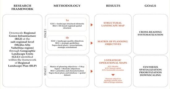
- Cross-reading and systematization of the extensive set of objectives, prescriptions and strategic guidelines provided by current planning tools (RLP, RTP, RTAP, PTCP) for the study area. Stage one moves from the spatial representation of the structural landscape elements identified by the GLU reports, integrated with the RGI spatial design components. As a result, a structural landscape map for the pilot area was outlined, combining GLU and RGI contents. Then, a cross-reading process of GLU landscape quality objectives, RGI guidelines and strategic orientations or prescriptions deriving from other supra-local planning tools were implemented to organise a Matrix of Planning Objectives. The aim of the matrix is to point out the correlations between each structural landscape element represented in the structural map and the several strategic objectives, guidelines or prescriptions directly affecting it, to allow for a synergic view of the different planning contents referred to spatialised elements.
- (ii)
- Downscaling the RGI spatial design components, from regional scale to GLU scale, as a result of a further cross-reading process applied to the Matrix of Planning Objectives contents. While in the first research stage, the cross-reading process was carried out to point out an exhaustive list of strategic contents selected from different planning tools, the aim of this further step is to provide a synthetic overview of the whole strategic contents listed in the matrix, identifying the main priorities of intervention for the study area, and spatializing them according to the RGI spatial design components. In stage two, cross-reading allows us to identify cross-cutting issues in order to combine the several “Planning Objectives” listed in the matrix into more synthetic “Thematic Objectives”. The so-called thematic objectives represent the strategic goals for the study area that can be applied to downscale the RGI, detailing both its spatial structure and the related guidelines, according to site-specific priorities and landscape features. Thematic objectives can be further ascribed to the following three key topics (KTs) identified as crucial issues for the entire Lombardy regional landscape: identity, natural capital, sustainable recreation. As a result of the RGI downscaling process, a pilot strategic operational map, articulated according to the three KTs, was created.
2.2.1. Assessment of Landscape Structure and Planning Objectives
2.2.2. Definition of Planning Strategies and Scaling GI: Data Sources and Spatialisation Process
- Protection and enhancement of the structural elements that provide a substantial contribution in defining the landscape identity of the study area, classified as “identity” (KT1);
- Protection and reinforcement of natural capital and biodiversity, classified as “natural capital” (KT2);
- Promotion of leisure and recreational landscape activities compatible with the preservation of local identity and environmental values, simplified as “sustainable recreation” (KT3).
- Representation of landscape elements in their spatial conformation: Natural, rural or anthropic landscape elements recognised as deserving specific strategies (e.g., glaciers, historical and cultural heritage, quarries, hydroelectric power plants, etc.) were represented, with geometric simplifications in some cases. They could be already included in the RGI spatial components, or they could interact with them. (Spatial data sources: regional and provincial geographic datasets, local socio-economic maps.)
- Representation of planned spatial strategies: Strategies set by supra-local plans (e.g., corridors or passages from regional ecological network, RGI buffer zones mitigating planned infrastructures, focus areas to implement landscape or environmental strategies, etc.), provided with inherent values and allocated to proper KTs, were represented without modifications. They could allow us to better detail the RGI spatial components or to integrate RGI design at local scale. (Spatial data sources: strategic datasets derived from planning tools in force, such as RLP; RTP; RTAP.)
- Elaborations by the authors combining RGI spatial components with datasets or elements involved in spatialised strategies: Starting from a group of territorial elements or spatial representations set by supra-local plans, the location of strategic areas descends from aggregation, filter and, in some cases, classification procedures (e.g., clip via RGI extent or risk areas, selection via contact with RGI, classification via landscape subtypes). They could allow us to better detail the RGI spatial components and the related strategic guidelines, or to integrate RGI design at local scale. (Spatial data sources: regional and provincial geographic datasets, national maps of hydrological instability areas, strategic datasets derived from the following plans: provincial forestry management plan; RGI; regional wildfire prevention plan; provincial quarries management plan.)
- Elaboration by authors combining several datasets to spatialise and prioritise strategic actions facing ongoing territorial phenomena: With various degrees of complexity, strategic areas are identified by authors’ elaborations consisting of, e.g., spatial analysis based on transformations in land use/land cover; selection of high visibility areas derived from GIS-based analysis; classification and interpretation of local socio-economic data. (Spatial data sources: regional and provincial geographic datasets, socio-economic data from the national institute for statistics, strategic datasets derived from RGI.)
- -
- Priority areas to tackle structural modifications and prevent risks on the hydrographic network (KT1a): The regional land use/land cover (LULC) of Lombardy was resized on high hydrological instability areas provided at a national scale by ISPRA (Italian Institute for Environmental Protection and Research acting under the vigilance and policy guidance of the Italian Ministry for the environment and energy security), locating areas next to rivers and streams that are at risk of flooding. Then, the selection was classified by predominant LULC types to diversify strategic actions. Selected areas that were primarily permeable (rural or natural LULC) were classified as “areas of safeguard of the river morphology and increase of the naturalistic values”, linking actions of increasing vegetation cover, supervised flooding or restoration of the natural river course. When waterways penetrated urban areas, priority areas were classified as “areas of hydrological risk prevention and increase of naturalistic values in urbanised context”, with actions of desealing or creation of retention basins. Priority areas along minor hydrographic networks were classified regardless of LULC type; for those areas, strategic actions include maintaining riparian vegetation and increasing morphological diversity of riverbeds.
- -
- High mountain landscapes visibility to be preserved (KT1a): With the aim of considering the perceptual characters of landscapes for preservation and enhancement purposes, a procedure to select high visibility reliefs in the pilot area was implemented, starting from a GIS-based visibility analysis. Using a digital terrain model (DTM) with a spatial resolution of 5 m, viewsheds from the main panoramic viewpoints, paths and routes were separately calculated. The procedure was integrated by calculating viewsheds from a selection of the most photographed points in the pilot area based on the visitation, recreation and tourism model of the free open-source suite of software models InVEST (Integrated Valuation of Ecosystem Services and Tradeoffs) [73], developed through a collaboration between different universities and international research and conservation centres for ES mapping and assessment. In particular, the visitation, recreation and tourism model aims to display the rate of visitation across landscapes using geotagged photos posted on the website Flickr as a proxy for the presence of visitors [74]. Raster viewsheds calculated from each layer of observation points were clipped to exclude valley floors and focus on mountains and slopes and then classified by visibility values adopting the natural breaks (Jenks) classification method to provide a consistent classification among the different viewsheds [75]. Finally, cells belonging to higher visibility classes were selected and aggregated, thus generating an overall map of high visibility areas in mountain landscapes, subject to specific preservation and enhancement actions.
- -
- Peri-urban rural areas to be preserved (KT2b): Chosen with the aim of detecting rural areas along urban fringes, which can be considered at risk of being enclosed by anthropic elements. A GIS-based selection by share of contact was performed. Rural plots from the regional LULC map were selected as priority areas if more than 50% of their perimeter was in contact with urban fabric or infrastructures. Then, to diversify strategic actions, RGI values were used as a filter to classify rural plots. Most of the selected areas, in fact, were included in the rural component of RGI and provided significant environmental and/or historical and cultural values. This led to a three-sided classification where RGI values’ co-presences are considered as vocations to guide strategic actions. In areas with high environmental values, local actions included the creation of allotments to be managed according to agroecology principles and increasing vegetation equipment for ecological restoration; in areas with high historical and cultural values, actions may also involve their reuse as public gardens or the refurbishment of abandoned rural buildings to support recreational uses. Areas with high values for both environmental and historical and cultural components are suitable to host actions related to both vocations.
- -
- Priority areas to tackle linear conurbation trends (KT2b): Firstly, LULC transitions from rural or natural land uses to urbanised areas that occurred in the past two decades were detected by clipping urbanised areas from current regional LULC maps on areas that were rural or natural in 1999, according to a former regional LULC map; then, a visual analysis was performed to identify conurbation trends, considering the spatial distribution of new urbanised areas, their linear aggregation along mobility infrastructures and the presence of neighbouring urban settlements subject to conjoining trends at the expense of rural or natural open spaces. Linear conurbation trends were represented as two collinear lines with converging arrows, indicating the direction of urban expansion. Strategic actions to tackle such trends include green buffer zones, hedgerows or tree rows along peri-urban rural areas and incentives to reuse abandoned buildings or complexes to avoid land take.
- -
- Attention and mitigation areas linked to possible functionality loss of low altitude ski resorts (KT3d): Present and future impacts of decreasing snowfalls on mountain activities are a risk factor for ski resorts, with increasing use of artificial snowmaking [76,77]. Ski resorts that can be more affected by the snowfall reduction were identified, suggesting alternative recreation strategies. Because climate in mountain areas may substantially vary depending on local factors, a recognised and potentially replicable criterion was chosen, known as the line of snow reliability (LSR), defined as the altitude that allows for a snow cover that is sufficient for at least 100 skiing days per season in a ski resort. OECD [78] estimates an LSR rise of 150 m per 1 °C of warming, starting from an LSR of 1500 m in alpine areas. Based on a supposed future scenario where LSR is set at 1650 m, percentages of each ski resort in the pilot area located below this altitude were calculated. Looking at the results, resorts whose future functionality may be considered at risk were selected by adopting a threshold corresponding to 40% or more of ski resort area below 1650 m. Priority areas descending from this procedure include a ski resort next to the town of Aprica (GLU 2.1) and some cross-country tracks generally located at lower altitudes than alpine skiing tracks.
- -
- Attention and mitigation areas linked to over-tourism impacts (KT3d): Since Media and Alta Valtellina territory relies considerably on tourism, issues related to tourist flows in fragile mountain contexts were highlighted, suggesting possible tackling strategies. In this case, tourism intensity—defined as the ratio of total overnight stays to total resident population [79]—was mapped at a municipality scale using data from Istat (the Italian National Institute of Statistics). The towns of Bormio and Livigno (GLU 2.1) show values remarkably higher than the other municipalities in the pilot area. They are, therefore, identified as attention and mitigation areas, where planning decisions that are able to combine the positive economic effects of tourism with environmental and landscape preservation must be adopted.
- -
- Areas substantially depending on winter tourism (KT3d): These priority areas represent municipalities where the local economy is tied to winter tourism activities—a condition that, combined with vulnerability to decreasing snowfalls, shall be considered a risk factor for the economy. To select such areas, municipal Istat data were analysed, including variance between tourist flows in the high season (winter and summer) and in the low season; the variance between winter and summer tourist flows; share of tourist facilities on overall local businesses. As a result of this combination of factors, Aprica municipality stands out as the most dependent on winter tourism and may take future advantage of diversifying recreation strategies.
3. Results
3.1. Strategic Operational Maps for the Pilot Area
3.1.1. KT1: Identity
- KT1a. To preserve unity and perceptions of hydrogeomorphological elements;
- KT1b. To preserve landscape values of natural elements;
- KT1c. To preserve constitutive features of the rural landscape;
- KT1d. To preserve the features representing the identity of the anthropic landscape.
3.1.2. KT2: Natural Capital
- KT2a. Promoting maintenance, reinforcement or reinstatement of ecological connectivity and high habitat quality;
- KT2b. Promoting reorganisation and defragmentation of peri-urban landscapes tackling loss of biodiversity;
- KT2c. Limiting, containing and mitigating impacts of anthropic activities.
3.1.3. KT3: Sustainable Recreation
- KT3a. Promoting sustainable recreation in natural heritage through soft mobility networks and landscape connections;
- KT3b. Supporting traditional and quality supply chains in farming, forestry and dairy products as multi-functional activities;
- KT3c. Promoting and enhancing recreation in historical and cultural heritage;
- KT3d. Exploring and promoting alternative tourism and recreation.
3.2. From GI to NBS: A Set of Actions for Local Implementation
4. Discussion
4.1. Main Findings of the RGI Downscaling Process
4.2. Replicability and Further Implementation
4.3. Methodological Limitations
4.4. Future Development and Perspectives
5. Conclusions
Supplementary Materials
Author Contributions
Funding
Institutional Review Board Statement
Informed Consent Statement
Data Availability Statement
Acknowledgments
Conflicts of Interest
References
- Dorst, H.; van der Jagt, S.; Raven, R.; Runhaar, H. Urban Greening through Nature-Based Solutions—Key Characteristics of an Emerging Concept. Sustain. Cities Soc. 2019, 49, 101620. [Google Scholar] [CrossRef]
- Albert, C.; Schröter, B.; Haase, D.; Brillinger, M.; Henze, J.; Herrmann, S.; Gottwald, S.; Guerrero, P.; Nicolas, C.; Matzdorf, B. Addressing Societal Challenges through Nature-Based Solutions: How Can Landscape Planning and Governance Research Contribute? Landsc. Urban Plan. 2019, 182, 12–21. [Google Scholar] [CrossRef]
- Meerow, S.; Newell, J.P. Spatial Planning for Multifunctional Green Infrastructure: Growing Resilience in Detroit. Landsc. Urban Plan. 2017, 159, 62–75. [Google Scholar] [CrossRef]
- Costanza, R.; D’Arge, R.; de Groot, R.; Farber, S.; Grasso, M.; Hannon, B.; Limburg, K.; Naeem, S.; O’Neill, R.V.; Paruelo, J.; et al. The Value of the World’s Ecosystem Services and Natural Capital. Nature 1997, 387, 253–260. [Google Scholar]
- Millennium Ecosystem Assessment. Ecosystems and Human Well-Being: A Framework for Assessment; Island Press: Washington, DC, USA, 2003; ISBN 9780128096659. [Google Scholar]
- European Commission. Building a Green Infrastructure for Europe; Publications Office of the European Union: Luxembourg, 2013; ISBN 9789279334283.
- Benedict, M.A.; McMahon, E.T. Green Infrastructure: Smart Conservation for the 21st Century. Renew. Resour. J. 2001, 20, 12–17. [Google Scholar]
- Hansen, R.; Pauleit, S. From Multifunctionality to Multiple Ecosystem Services? A Conceptual Framework for Multifunctionality in Green Infrastructure Planning for Urban Areas. Ambio 2014, 43, 516–529. [Google Scholar] [CrossRef] [Green Version]
- Kambites, C.; Owen, S. Renewed Prospects for Green Infrastructure Planning in the UK. Plan. Pract. Res. 2006, 21, 483–496. [Google Scholar] [CrossRef]
- Benedict, M.E.; Mcmahon, E.T. Green Infrastructure. Linking Landscapes and Communities; Island Press: Washington, DC, USA, 2006; ISBN 9781597267649. [Google Scholar]
- Pauleit, S.; Liu, L.; Ahern, J.; Kazmierczak, A. Multifunctional Green Infrastructure Planning to Promote Ecological Services in the City. In Urban Ecology: Patterns, Processes, and Applications; Niemelä, J., Breuste, J.H., Elmqvist, T., Guntenspergen, G., James, P., McIntyre, N.E., Eds.; Oxford Scholarship Online: Oxford, UK, 2011; pp. 272–285. [Google Scholar]
- Fisher, B.; Turner, R.K.; Morling, P. Defining and Classifying Ecosystem Services for Decision Making. Ecol. Econ. 2009, 68, 643–653. [Google Scholar] [CrossRef] [Green Version]
- Langemeyer, J.; Gómez-Baggethun, E.; Haase, D.; Scheuer, S.; Elmqvist, T. Bridging the Gap between Ecosystem Service Assessments and Land-Use Planning through Multi-Criteria Decision Analysis (MCDA). Environ. Sci. Policy 2016, 62, 45–56. [Google Scholar] [CrossRef]
- Ersoy Mirici, M. The Ecosystem Services and Green Infrastructure: A Systematic Review and the Gap of Economic Valuation. Sustainability 2022, 14, 517. [Google Scholar] [CrossRef]
- European Commission. Mapping and Assessment of Ecosystems and Their Services. Urban Ecosystems 4th Report; Office for Official Publications of the European Communities: Luxembourg, 2016; ISBN 9789279361616. [Google Scholar]
- Arcidiacono, A.; Ronchi, S.; Salata, S. Managing Multiple Ecosystem Services for Landscape Conservation: A Green Infrastructure in Lombardy Region. Procedia Eng. 2016, 161, 2297–2303. [Google Scholar]
- Cortinovis, C.; Geneletti, D. Mapping and Assessing Ecosystem Services to Support Urban Planning: A Case Study on Brownfield Regeneration in Trento, Italy. One Ecosyst. 2018, 3, e25477. [Google Scholar] [CrossRef]
- Maes, J.; Zulian, G.; Günther, S.; Thijssen, M.; Reynal, J. Enhancing Resilience of Urban Ecosystems through Green Infrastructure (EnRoute) Final Report; Publications Office of the European Union: Luxembourg, 2019; ISBN 978-92-79-98984-1.
- Van Oijstaeijen, W.; Van Passel, S.; Cools, J. Urban Green Infrastructure: A Review on Valuation Toolkits from an Urban Planning Perspective. J. Environ. Manag. 2020, 267, 110603. [Google Scholar] [CrossRef]
- Gómez-Baggethun, E.; Barton, D.N. Classifying and Valuing Ecosystem Services for Urban Planning. Ecol. Econ. 2013, 86, 235–245. [Google Scholar] [CrossRef]
- Ronchi, S.; Arcidiacono, A.; Pogliani, L. Integrating Green Infrastructure into Spatial Planning Regulations to Improve the Performance of Urban Ecosystems. Insights from an Italian Case Study. Sustain. Cities Soc. 2020, 53, 101907. [Google Scholar] [CrossRef]
- European Commission. EU Biodiversity Strategy for 2030: Bringing Nature Back into Our Lives. COM(2020) 380 Final; European Commission: Brussels, Belgium, 2020. [Google Scholar]
- Zulian, G.; Ronchi, S.; La Notte, A.; Vallecillo, S.; Maes, J. Adopting a Cross-Scale Approach for the Deployment of a Green Infrastructure. One Ecosyst. 2021, 6, 1–29. [Google Scholar]
- Hermoso, V.; Carvalho, S.B.; Giakoumi, S.; Goldsborough, D.; Katsanevakis, S.; Leontiou, S.; Markantonatou, V.; Rumes, B.; Vogiatzakis, I.N.; Yates, K.L. The EU Biodiversity Strategy for 2030: Opportunities and Challenges on the Path towards Biodiversity Recovery. Environ. Sci. Policy 2022, 127, 263–271. [Google Scholar] [CrossRef]
- Cortinovis, C.; Geneletti, D. Ecosystem Services in Urban Plans: What Is There, and What Is Still Needed for Better Decisions. Land Use Policy 2018, 70, 298–312. [Google Scholar] [CrossRef]
- Cortinovis, C.; Geneletti, D. A Framework to Explore the Effects of Urban Planning Decisions on Regulating Ecosystem Services in Cities. Ecosyst. Serv. 2019, 38, 100946. [Google Scholar] [CrossRef]
- Di Marino, M.; Tiitu, M.; Lapintie, K.; Viinikka, A.; Kopperoinen, L. Integrating Green Infrastructure and Ecosystem Services in Land Use Planning. Results from Two Finnish Case Studies. Land Use Policy 2019, 82, 643–656. [Google Scholar] [CrossRef]
- de Groot, R.; Alkemade, R.; Braat, L.; Hein, L.; Willemen, L. Challenges in Integrating the Concept of Ecosystem Services and Values in Landscape Planning, Management and Decision Making. Ecol. Complex. 2010, 7, 260–272. [Google Scholar] [CrossRef]
- Mascarenhas, A.; Ramos, T.B.; Haase, D.; Santos, R. Ecosystem Services in Spatial Planning and Strategic Environmental Assessment-A European and Portuguese Profile. Land Use Policy 2015, 48, 158–169. [Google Scholar] [CrossRef]
- Baró, F.; Palomo, I.; Zulian, G.; Vizcaino, P.; Haase, D.; Gómez-Baggethun, E. Mapping Ecosystem Service Capacity, Flow and Demand for Landscape and Urban Planning: A Case Study in the Barcelona Metropolitan Region. Land Use Policy 2016, 57, 405–417. [Google Scholar] [CrossRef] [Green Version]
- Grêt-Regamey, A.; Altwegg, J.; Sirén, E.A.; van Strien, M.J.; Weibel, B. Integrating Ecosystem Services into Spatial Planning—A Spatial Decision Support Tool. Landsc. Urban Plan. 2017, 165, 206–219. [Google Scholar] [CrossRef] [Green Version]
- Seiwert, A.; Rößler, S. Understanding the Term Green Infrastructure: Origins, Rationales, Semantic Content and Purposes as Well as Its Relevance for Application in Spatial Planning. Land Use Policy 2020, 97, 104785. [Google Scholar] [CrossRef]
- Grădinaru, S.R.; Hersperger, A.M. Green Infrastructure in Strategic Spatial Plans: Evidence from European Urban Regions. Urban For. Urban Green. 2019, 40, 17–28. [Google Scholar] [CrossRef]
- Lafortezza, R.; Davies, C.; Sanesi, G.; Konijnendijk, C.C.C. Green Infrastructure as a Tool to Support Spatial Planning in European Urban Regions. iForest-Biogeosci. For. 2013, 6, 102–108. [Google Scholar] [CrossRef] [Green Version]
- Scholes, R.; Reyers, B.; Biggs, R.; Spierenburg, M.; Duriappah, A. Multi-Scale and Cross-Scale Assessments of Social–Ecological Systems and Their Ecosystem Services. Curr. Opin. Environ. Sustain. 2013, 5, 16–25. [Google Scholar] [CrossRef]
- European Commission. Communication from the Commission to the European Parliament, the Council, the European Economic and Social Committee and the Committee of the Regions. Green Infrastructure (GI)—Enhancing Europe’s Natural Capital {SWD(2013) 155 Final}; European Commission: Bruxelles, Belgium, 2013; Volume 51. [Google Scholar]
- European Commission. Review of Progress on Implementation of the EU Green Infrastructure Strategy. COM(2019) 236 Final; European Commission: Brussels, Belgium, 2019. [Google Scholar]
- European Commission. The European Green Deal. COM(2019) 640 Final; European Commission: Bruxelles, Belgium, 2019. [Google Scholar]
- Ronchi, S. Ecosystem Services for Spatial Planning. Innovative Approaches and Challenges for Practical Applications; Green Ener; Springer: Cham, Switzerland, 2018; ISBN 9783319901848. [Google Scholar]
- Kopperoinen, L.; Itkonen, P.; Niemelä, J. Using Expert Knowledge in Combining Green Infrastructure and Ecosystem Services in Land Use Planning: An Insight into a New Place-Based Methodology. Landsc. Ecol. 2014, 29, 1361–1375. [Google Scholar] [CrossRef]
- Staccione, A.; Candiago, S.; Mysiak, J. Mapping a Green Infrastructure Network: A Framework for Spatial Connectivity Applied in Northern Italy. Environ. Sci. Policy 2022, 131, 57–67. [Google Scholar] [CrossRef]
- Slätmo, E.; Nilsson, K.; Turunen, E. Implementing Green Infrastructure in Spatial Planning in Europe. Land 2019, 8, 62. [Google Scholar] [CrossRef] [Green Version]
- Donati, G.F.A.; Bolliger, J.; Psomas, A.; Maurer, M.; Bach, P.M. Reconciling Cities with Nature: Identifying Local Blue-Green Infrastructure Interventions for Regional Biodiversity Enhancement. J. Environ. Manag. 2022, 316, 115254. [Google Scholar] [CrossRef]
- Isola, F.; Lai, S.; Leone, F.; Zoppi, C. Strengthening a Regional Green Infrastructure through Improved Multifunctionality and Connectedness: Policy Suggestions from Sardinia, Italy. Sustainability 2022, 14, 9788. [Google Scholar] [CrossRef]
- Herreros-Cantis, P.; McPhearson, T. Mapping Supply of and Demand for Ecosystem Services to Assess Environmental Justice in New York City. Ecol. Appl. 2021, 31, e02390. [Google Scholar] [CrossRef]
- Kremer, P.; Hamstead, Z.A.; McPhearson, T. The Value of Urban Ecosystem Services in New York City: A Spatially Explicit Multicriteria Analysis of Landscape Scale Valuation Scenarios. Environ. Sci. Policy 2015, 62, 57–68. [Google Scholar] [CrossRef]
- Salata, S.; Özkavaf-Şenalp, S.; Velibeyoğlu, K. Integrating Ecosystem Vulnerability in the Environmental Regulation Plan of Izmir (Turkey)—What Are the Limits and Potentialities? Urban Sci. 2022, 6, 19. [Google Scholar] [CrossRef]
- Pauleit, S.; Ambrose-Oji, B.; Andersson, E.; Anton, B.; Buijs, A.; Haase, D.; Elands, B.; Hansen, R.; Kowarik, I.; Kronenberg, J.; et al. Advancing Urban Green Infrastructure in Europe: Outcomes and Reflections from the GREEN SURGE Project. Urban For. Urban Green. 2019, 40, 4–16. [Google Scholar] [CrossRef]
- Minoia, P.; Zanetto, G. An Assessment of the Principle of Subsidiarity in Urban Planning to Face Climate Change The Case of Martellago, Venice Province. Int. J. Clim. Chang. Strateg. Manag. 2009, 1, 63–74. [Google Scholar] [CrossRef] [Green Version]
- Cattivelli, V. Land Use Policy Planning Peri-Urban Areas at Regional Level: The Experience of Lombardy. Land Use Policy 2021, 103, 105282. [Google Scholar] [CrossRef]
- Lennon, M.; Scott, M. Delivering Ecosystems Services via Spatial Planning: Reviewing the Possibilities and Implications of a Green Infrastructure Approach. Town Plan. Rev. 2014, 85, 563–587. [Google Scholar] [CrossRef] [Green Version]
- Demuzere, M.; Orru, K.; Heidrich, O.; Olazabal, E.; Geneletti, D.; Orru, H.; Bhave, A.G.; Mittal, N.; Feliu, E.; Faehnle, M. Mitigating and Adapting to Climate Change: Multi-Functional and Multi-Scale Assessment of Green Urban Infrastructure. J. Environ. Manag. 2014, 146, 107–115. [Google Scholar] [CrossRef]
- Arthur, N.; Hack, J. A Multiple Scale, Function, and Type Approach to Determine and Improve Green Infrastructure of Urban Watersheds. Urban For. Urban Green. 2022, 68, 127459. [Google Scholar] [CrossRef]
- Zardo, L.; Geneletti, D.; Pérez-Soba, M.; Van Eupen, M. Estimating the Cooling Capacity of Green Infrastructures to Support Urban Planning. Ecosyst. Serv. 2017, 26, 225–235. [Google Scholar] [CrossRef]
- Council of Europe. European Landscape Convention; Council of Europe Publishing Division: Strasbourg, France, 2000; Available online: https://rm.coe.int/16807b6bc7 (accessed on 13 July 2023).
- Arcidiacono, A.; Ronchi, S. Ecosystem Services and Green Infrastructure. Perspectives from Spatial Planning in Italy; Springer International Publishing: Berlin/Heidelberg, Germany, 2020; ISBN 9783030543440. [Google Scholar]
- Agnoletti, M.; Santoro, A. The Lombard Forest Landscape. A Historical Summary. In Land Cover Changes in Lombardy over the Last 50 Years; ERSAF Regione Lombardia: Milan, Italy, 2012; pp. 131–156. [Google Scholar]
- Oppio, A.; Corsi, S.; Mattia, S.; Tosini, A. Exploring the Relationship among Local Conflicts and Territorial Vulnerability: The Case Study of Lombardy Region. Land Use Policy 2015, 43, 239–247. [Google Scholar] [CrossRef] [Green Version]
- Schirpke, U.; Leitinger, G.; Tasser, E.; Schermer, M.; Steinbacher, M.; Tappeiner, U. Multiple Ecosystem Services of a Changing Alpine Landscape: Past, Present and Future. Int. J. Biodivers. Sci. Ecosyst. Serv. Manag. 2013, 9, 123–135. [Google Scholar] [CrossRef]
- Campagnaro, T.; Frate, L.; Carranza, M.L.; Sitzia, T. Multi-Scale Analysis of Alpine Landscapes with Different Intensities of Abandonment Reveals Similar Spatial Pattern Changes: Implications for Habitat Conservation. Ecol. Indic. 2017, 74, 147–159. [Google Scholar] [CrossRef]
- Jiménez-Olivencia, Y.; Ibáñez-Jiménez, Á.; Porcel-Rodríguez, L.; Zimmerer, K. Land Use Change Dynamics in Euro-Mediterranean Mountain Regions: Driving Forces and Consequences for the Landscape. Land Use Policy 2021, 109, 105721. [Google Scholar] [CrossRef]
- Bazzanella, F.; Bichler, B.F.; Schnitzer, M. Collaboration and Meta-Organisation in Event Tourism—Effects of the Olympic Agenda 2020 on Planning the 2026 Winter Olympics. Tour. Manag. Perspect. 2022, 41, 100939. [Google Scholar] [CrossRef]
- Chappelet, J.-L. Olympic Environmental Concerns as a Legacy of the Winter Games. Int. J. Hist. Sport 2008, 25, 1884–1902. [Google Scholar] [CrossRef]
- Song, S.; Zhang, S.; Wang, T.; Meng, J.; Zhou, Y.; Zhang, H. Balancing Conservation and Development in Winter Olympic Construction: Evidence from a Multi-Scale Ecological Suitability Assessment. Sci. Rep. 2018, 8, 14083. [Google Scholar] [CrossRef] [Green Version]
- Zhang, H.; Yu, Y.; Zha, T.; Rodrigo-Comino, J. Assessing Previous Land-Vegetation Productivity Relationships on Mountainous Areas Hosting Coming Winter Olympics Games in 2022. Sci. Total Environ. 2021, 788, 147870. [Google Scholar] [CrossRef] [PubMed]
- Stobbelaar, D.J.; Pedroli, B. Perspectives on Landscape Identity: A Conceptual Challenge Perspectives on Landscape Identity: A Conceptual Challenge. Landsc. Res. 2011, 36, 321–339. [Google Scholar] [CrossRef]
- Kaligarič, M.; Ivajnšič, D. Vanishing Landscape of the “Classic” Karst: Changed Landscape Identity and Projections for the Future. Landsc. Urban Plan. 2014, 132, 148–158. [Google Scholar] [CrossRef]
- Costanza, R.; Daly, H.E. Natural Capital and Sustainable Development. Conserv. Biol. 1992, 6, 37–46. [Google Scholar]
- Vardon, M.; Bass, S. (Eds.) Natural Capital Accounting for Better Policy Decisions: Measuring and Valuing Natural Capital to Improve Landscape Management and Governance. In Proceedings of the 4th Forum on Natural Capital Accounting for Better Policy Decisions, Kampala, Uganda, 18–19 November 2019. [Google Scholar]
- Blaschke, T. The Role of the Spatial Dimension within the Framework of Sustainable Landscapes and Natural Capital. Landsc. Urban Plan. 2006, 75, 198–226. [Google Scholar] [CrossRef]
- Kulczyk, S.; Woźniak, E.; Derek, M. Landscape, Facilities and Visitors: An Integrated Model of Recreational Ecosystem Services. Ecosyst. Serv. 2018, 31, 491–501. [Google Scholar] [CrossRef]
- De Valck, J.; Landuyt, D.; Broekx, S.; Liekens, I.; De Nocker, L.; Vranken, L. Outdoor Recreation in Various Landscapes: Which Site Characteristics Really Matter? Land Use Policy 2017, 65, 186–197. [Google Scholar] [CrossRef]
- Nelson, E.; Ennaanay, D.; Wolny, S.; Olwero, N.; Pennington, D.; Mendoza, G.; Aukema, J.; Foster, J.; Forrest, J.; Cameron, D.; et al. InVEST 2.0 Beta User’s Guide: Integrated Valuation of Ecosystem Services and Tradeoffs; Woods Institute for the Environment, Stanford University: California, CA, USA, 2011; Available online: http://data.naturalcapitalproject.org/nightly-build/invest-users-guide/html/ (accessed on 13 July 2023).
- Keeler, B.L.; Wood, S.A.; Polasky, S.; Kling, C.; Filstrup, C.T.; Downing, J.A. Recreational Demand for Clean Water: Evidence from Geotagged Photographs by Visitors to Lakes. Front. Ecol. Environ. 2015, 13, 76–81. [Google Scholar] [CrossRef] [Green Version]
- North, M.A.; College, J. A Method for Implementing a Statistically Significant Number of Data Classes in the Jenks Algorithm. In Proceedings of the 2009 Sixth International Conference on Fuzzy Systems and Knowledge Discovery, Tianjin, China, 14–16 August 2009; Volume 1, pp. 35–38. [Google Scholar] [CrossRef]
- Steiger, R.; Scott, D.; Abegg, B.; Pons, M.; Aall, C. A Critical Review of Climate Change Risk for Ski Tourism. Curr. Issues Tour. 2019, 22, 1343–1379. [Google Scholar] [CrossRef] [Green Version]
- Vorkauf, M.; Steiger, R.; Abegg, B.; Hiltbrunner, E. Snowmaking in a Warmer Climate: An in-Depth Analysis of Future Water Demands for the Ski Resort Andermatt-Sedrun-Disentis (Switzerland) in the Twenty-First Century. Int. J. Biometeorol. 2022. [Google Scholar] [CrossRef] [PubMed]
- Abegg, B.; Agrawala, C.; Crick, F.; de Montfalcon, A. Climate Change in the European Alps; Agrawala, S., Ed.; OECD: Paris, France, 2006; ISBN 9264031685. [Google Scholar]
- Batista e Silva, F.; Marín Herrera, M.A.; Rosina, K.; Ribeiro Barranco, R.; Freire, S.; Schiavina, M. Analysing Spatiotemporal Patterns of Tourism in Europe at High-Resolution with Conventional and Big Data Sources. Tour. Manag. 2018, 68, 101–115. [Google Scholar] [CrossRef]
- European Commission. Communication from the Commission to the European Parliament, the Council, the European Economic and Social Committee, the Committee of the Regions and the European Investment Bank "A Framework Strategy for a Resilient Energy Union with a Forward-Looking; European Commission: Bruxelles, Belgium, 2015. [Google Scholar]
- Maes, J.; Jacobs, S. Nature-Based Solutions for Europe’s Sustainable Development. Conserv. Lett. 2017, 10, 121–124. [Google Scholar] [CrossRef] [Green Version]
- Colavitti, A.M.; Serra, S. Regional Landscape Planning and Local Planning. Insights from the Italian Context. J. Settl. Spat. Plan. 2021, 2021, 81–91. [Google Scholar] [CrossRef]
- Argenziano, M.; Deffacis, J.; Gamalero, B.; Paludi, G. La Struttura. Atti Rass. Tec. Soc. Ing. Archit. Torino 2018, 3, 27–33. [Google Scholar]
- Nadin, V.; Fernández, M.; Maldonado, A.; Zonneveld, W.; Stead, D.; Dąbrowski, M.; Piskorek, K.; Sarkar, A.; Schmitt, P.; Smas, L.; et al. COMPASS Final Report; ESPON & TU Delft: Luxembourg, 2018; ISBN 978-99959-55-55-7. [Google Scholar]
- Galler, C.; Albert, C.; von Haaren, C. From Regional Environmental Planning to Implementation: Paths and Challenges of Integrating Ecosystem Services. Ecosyst. Serv. 2016, 18, 118–129. [Google Scholar] [CrossRef]
- Hersperger, A.M.; Bürgi, M.; Wende, W.; Bacău, S.; Grădinaru, S.R. Does Landscape Play a Role in Strategic Spatial Planning of European Urban Regions? Landsc. Urban Plan. 2020, 194, 103702. [Google Scholar] [CrossRef]
- Perrin, M.; Bertrand, N.; Vanpeene, S. Ecological Connectivity in Spatial Planning: From the EU Framework to Its Territorial Implementation in the French Context. Environ. Sci. Policy 2022, 129, 118–125. [Google Scholar] [CrossRef]


Disclaimer/Publisher’s Note: The statements, opinions and data contained in all publications are solely those of the individual author(s) and contributor(s) and not of MDPI and/or the editor(s). MDPI and/or the editor(s) disclaim responsibility for any injury to people or property resulting from any ideas, methods, instructions or products referred to in the content. |
© 2023 by the authors. Licensee MDPI, Basel, Switzerland. This article is an open access article distributed under the terms and conditions of the Creative Commons Attribution (CC BY) license (https://creativecommons.org/licenses/by/4.0/).
Share and Cite
Pristeri, G.; di Martino, V.; Ronchi, S.; Salata, S.; Mazza, F.; Benedini, A.; Arcidiacono, A. An Operational Model to Downscale Regional Green Infrastructures in Supra-Local Plans: A Case Study in an Italian Alpine Sub-Region. Sustainability 2023, 15, 11542. https://doi.org/10.3390/su151511542
Pristeri G, di Martino V, Ronchi S, Salata S, Mazza F, Benedini A, Arcidiacono A. An Operational Model to Downscale Regional Green Infrastructures in Supra-Local Plans: A Case Study in an Italian Alpine Sub-Region. Sustainability. 2023; 15(15):11542. https://doi.org/10.3390/su151511542
Chicago/Turabian StylePristeri, Guglielmo, Viviana di Martino, Silvia Ronchi, Stefano Salata, Francesca Mazza, Andrea Benedini, and Andrea Arcidiacono. 2023. "An Operational Model to Downscale Regional Green Infrastructures in Supra-Local Plans: A Case Study in an Italian Alpine Sub-Region" Sustainability 15, no. 15: 11542. https://doi.org/10.3390/su151511542
APA StylePristeri, G., di Martino, V., Ronchi, S., Salata, S., Mazza, F., Benedini, A., & Arcidiacono, A. (2023). An Operational Model to Downscale Regional Green Infrastructures in Supra-Local Plans: A Case Study in an Italian Alpine Sub-Region. Sustainability, 15(15), 11542. https://doi.org/10.3390/su151511542