Article

Safety Risk Assessment of Low-Volume Road Segments on the Tibetan Plateau Using UAV LiDAR Data

1
Key Laboratory of Environmental Change and Natural Disasters, Ministry of Education, Beijing Normal University, Beijing 100875, China
2
State Key Laboratory of Earth Surface Processes and Resource Ecology (ESPRE), Beijing Normal University, Beijing 100875, China
3
Academy of Disaster Reduction and Emergency Management, Ministry of Emergency Management and Ministry of Education, Beijing 100875, China
4
Faculty of Geographical Science, Beijing Normal University, Beijing 100875, China
*
Author to whom correspondence should be addressed.
Sustainability 2023, 15(14), 11443; https://doi.org/10.3390/su151411443
Submission received: 5 June 2023 / Revised: 14 July 2023 / Accepted: 18 July 2023 / Published: 24 July 2023

Abstract

:
The intricate topography and numerous hazards of highland roads contribute to a significantly higher incidence of traffic accidents on these roads compared to those on the plains. Although precise road data can enhance the safety evaluation and management of these road segments, the cost of data acquisition in highland areas is prohibitively high. To tackle this issue, our paper proposes a system of assessment indices and extraction methods specifically designed for plateau regions, supplementing existing road safety audit techniques. We are pioneers in integrating a high-precision 3D point cloud model into the safety risk assessment of low-traffic plateau roads, utilizing unmanned aerial vehicle (UAV) LiDAR technology. This innovative approach enhances both the efficiency and accuracy of road mapping. Building on this, we amalgamated three categories of indices—road 3D alignment, geographical environment, and natural disasters—to formulate a comprehensive safety risk assessment model. Applying this model to seventeen representative road segments on the Tibetan Plateau, we found that road alignment significantly influences road safety risk. The segments with the highest risk ratings are predominantly those located in the southwestern part of the Tibetan region, such as Zanda and Gar. Road safety management should prioritize road alignment, particularly the role of the curve radius, without overlooking the impact of environmental factors and natural disasters.

1. Introduction

An efficient and robust road system is the cornerstone of a nation’s sustainable economic and social development. The number of traffic accidents has generally increased in China. Over the past ten years, the average number of car accidents per year has been about 146,113, accounting for 67.77% of the total traffic accidents, with 44,257 deaths and direct economic losses of about CNY 1021.86 million per year. Therefore, road safety risk assessment is essential to reduce casualties and property damage. We are able to identify potential dangers that may lead to accidents, determine the factors affecting traffic safety and objectively describe their effectiveness [1]. Such information helps to prevent and reduce traffic accidents, improving road safety and reducing the cost of road operation and management [2].
The Tibetan Plateau is a significant ecological security barrier for China and even Asia [3]. The area has low road capacity and traffic volumes [4]. Compared to other cities in China, Tibet ranked the lowest in average daily traffic volume in 2020, accounting for only 4.2% of the city with the highest value (Shanghai). According to the results compiled from the National Highway Traffic Status Report, the traffic volume on the five national highways in and out of Tibet is low. The Qinghai–Tibet Highway, which has the highest traffic volume, has an annual average daily traffic volume of around 2500 vehicles per day. The second is the Chengzhang Highway (G318), with an annual average daily traffic volume of about 455 vehicles per day, and the other three national highways have a traffic volume of less than 400 vehicles per day [5]. Only the Qinghai–Tibet Highway is open to traffic all year round. Natural disasters such as snow and ice in winter and mudslides in summer cause the remaining national highways to be open to traffic intermittently. Since the opening of the Qinghai–Tibet Railway, the Qinghai–Tibet highway has seen a sharp decline in its daily traffic volume [6]. Even though the roads are already low-volume, the region experiences higher average rates of single-vehicle accidents and higher average accident fatality rates than other Chinese regions [7]. In China, traffic accidents on low-volume roads, especially in remote highland mountainous areas, have reached a critical level [6].
At present, many scholars are studying traffic accidents and their causes on the highway and urban roads, for which safety assessment technology is more advanced [8]. Compared with urban roads, research on highland road safety has received limited attention. The Tibetan Plateau, one of the world’s most unique geographical regions, faces threats to its transport infrastructure due to its extreme climate, rugged topography, and frequent hazards [9]. Given the wide variation among road sections, it is crucial to select specific road segments for safety risk assessment in order to prevent traffic accidents and minimize casualties. Traditional road safety assessments, which rely on field measurements being taken by surveyors, are challenging and costly in remote highland areas due to the complex topography and environment. Therefore, we attempted to use unmanned aerial vehicle (UAV) LiDAR scanning technology to improve the accuracy and efficiency of data collection, providing practical technical support for road safety risk assessment.
The contributions of this work are presented as follows: we establish a road safety assessment framework applicable to the Tibetan Plateau by combining the hazard and environmental characteristics of high-altitude areas. Meanwhile, we use the data acquired by UAV LiDAR as the input, improving the accuracy of the data and the convenience of road safety audits.
The rest of this paper is organized as follows: Section 2 provides a review of road safety assessment and measurement methods. Section 3 mainly introduces the study area’s situation. Section 4 designs the road safety risk indices and constructs a road safety risk assessment model. Then, Section 5 applies the assessment model to road segments and analyzes their risk characteristics. Finally, Section 6 concludes and discusses the paper.

2. Literature Review

2.1. Road Safety Risk Assessment

The road segment safety risk assessment methods can be divided into those based on accident data and those based on road performance indices. The former methods use the history of past accidents as input data. The latter methods rely on the inspection of indices to detect safety deficiencies.
Evaluating road safety based on historical data can identify true accident black spots [10,11], but it highly depends on the accuracy and availability of accident data. Insufficient accident data can lead to the failure to identify potential hazards for areas or road sections with sparse traffic volumes. Moreover, Tibet has a small resident population, and some areas are tourist hotspots. The overall traffic flow in this region is small but unevenly distributed, so the accident sample is insufficient to reflect road safety conditions [6]. Consequently, road safety analysis for Tibet is more applicable and feasible when a comprehensive assessment of road safety factors is conducted.
In studies of index-based road safety assessment, the main factors can be divided into three general categories: the first is road design and road alignments, such as geometric consistency indices, surface conditions [8], lane width, and intersection density [12]; the second is the road surroundings, such as the distribution of settlements around the road segment [13], road structures [14] and the environment [15]; and the third is the vehicle driving status, such as vehicle driving and traffic flow [16]. The above studies mainly focus on general road traffic systems, but such areas as the Tibetan Plateau must be fully considered for their unique characteristics. Complex and varied road alignments, such as steep slopes and sharp curves, are formed by complex topography [17]. The harsh driving environment, such as low pressures and a lack of oxygen, affects driver judgment and vehicle dynamics [18]. Different hazards, such as earthquakes, hydrological and meteorological natural disasters, can affect regional safety [9].
Despite its many noteworthy unique characteristics, research on remote highland road safety is limited. Most studies have been conducted on road alignment and the traffic environment [19]. For example, Zhong (2014) [20] constructed an assessment index system containing the traffic environment, traffic flow condition, and road design data of a road section through design information and expert interviews. Hu (2020) [21] proposed the suggested values of key alignment indicators by simulating the impact of plateau road alignment on driver physiology and psychology. There is a lack of research to consider the risk of natural disasters. This is because disasters are sudden and often easy to overlook in field measurements, but they can significantly impact travel safety [22]. In addition, the road data for the above studies are mainly derived from simulation modeling or design schemes. However, this information lacks field validation, and it is challenging to conduct road safety assessments without management information. Therefore, there is no well-developed framework for research on road safety risk assessment in the plateau, and data acquisition is a major bottleneck to the problem. Highland conditions increase the risk and cost of obtaining accurate data for road segments.

2.2. LiDAR Measurement Technology

Currently, remote sensing has been incorporated into road surveys. For instance, road surveyors manually digitize lanes from aerial images and interpolate 3D models with sparse ground GNSS (Global Navigation Satellite System) measurements, which mitigates the disadvantages of field surveys. However, the accuracy of GNSS limits the accuracy of 3D models [23]. LiDAR provides the technology required to acquire high-precision models, reducing data collection and the processing time. It has been determined that the correctness and completeness of measurements are significantly improved by LiDAR. Therefore, we use the data acquired by LiDAR as an input source for the road safety risk assessment. LiDAR has been used in many areas of pavement recognition [24], road width [25], road geometric consistency [26], line-of-sight analysis [27], lane identification [28], and pavement crack and distress detection [29,30], providing more possibilities for comprehensive road safety assessment. For example, Antonio (2018) [26] assessed road safety by extracting road horizontal alignments from a mobile LiDAR system in order to obtain geometric consistency indices. Ravi (2020) [28] proposed a method used to estimate lane widths using LiDAR-based mobile mapping systems to collect detailed information about the road surface. However, most of the literature considers only separate road feature indices. In real-life scenarios, drivers may be distracted by road conditions, environmental, vehicular, or other factors. Therefore, the refined road data should be integrated with environmental and other indices in the assessment process so to be more informative.
The scanning range of mobile LiDAR is limited and does not provide sufficient information about the road environment. In recent years, UAV laser scanning (ULS) has been utilized extensively as a promising technology. The UAV LiDAR also acquires point cloud data, but has the following advantages [31]. First, ULS provides a sufficient coverage area for road safety assessment. Second, ULS can give a complete sample of the road boundaries and markings unaffected by obstacle occlusion. Third, collecting data via ULS is cheap and ensures the safety of drivers and surveyors. Researchers have already developed processing methods and analysis frameworks for the UAV-based point cloud. For example, Mohan (2021) [32] has developed a fully automated highway inspection framework based on a convolutional neural network using a novel low-power drone. Biçici (2021) [33] has proposed a method for road classification and extraction from a UAV point cloud based on random forest and further combines it with the Voronoi diagram to improve the quality of road centerline extraction [34]. These techniques make ULS data ideal for road safety assessment.
As a result, we designed the assessment framework presented in this paper using UAV LiDAR data, thus providing an efficient and high-precision measurement method for road safety inspection.

3. Study Area and Data Sources

3.1. Study Area

The study area includes Rikaze (Namling, Yadong, Kamba, Dinggye, Nyalam, Gyirong, and Zhongba); Ngari Prefecture (Purang, Zanda, Gar, Rutog, and Ge’gyai); and Nagqu (Nyima, Shenza, and Baingoin). As shown in Figure 1, data collection and analysis included seventeen specific road segments: national, provincial, county, and village roads.
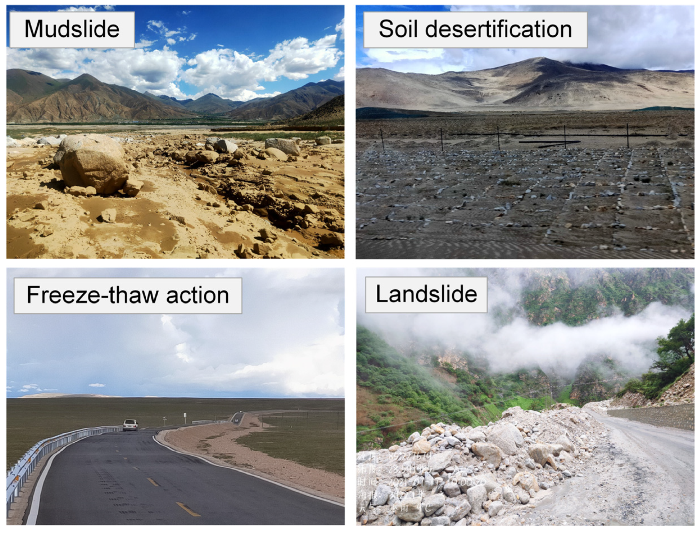
Affected by climate, topography, and geology, natural disasters such as soil desertification, freeze–thaw action, mudslides, and landslides are frequent, dangerous, and widely distributed, posing a significant threat to the safety of road construction projects. Figure 2 depicts the hazard zones close to the road.
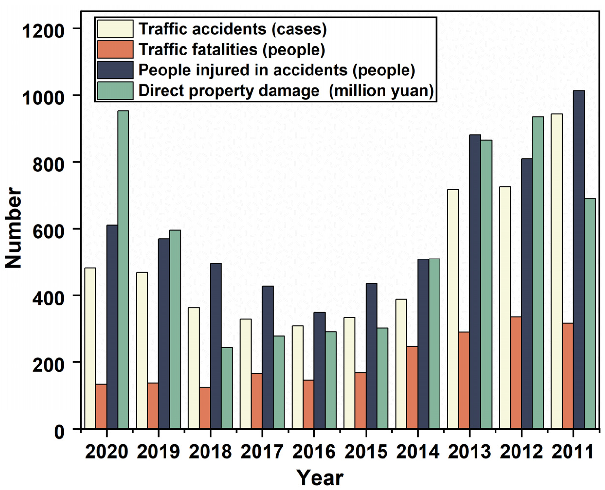
According to statistics, the single-vehicle accident rate in Tibet is 1.58% higher than the regional average, and the average accident fatality rate per period is 2.19 times higher [35]. Figure 3 shows that the road traffic safety situation continues to be dismal. Analyzing road safety in order to reduce traffic accidents and enhance driving safety is essential.

3.2. Data Sources

We used data from field measurements and open-source databases. The road 3D data acquisition equipment utilized the DJI Matrice 300 RTK UAV, outfitted with Zenmuse L1 LiDAR (elevation accuracy: 5 cm; plane accuracy: 10 cm), an inertial guidance system, an auxiliary positioning camera, and a mapping camera. It can simultaneously collect LiDAR point clouds and RGB images. The environmental data were mainly obtained from the Tibetan Plateau scientific research database and published studies, as shown in Table 1.

4. Road Safety Risk Assessment Method

4.1. Assessment Index Selection

The Tibetan region has a complex topography and is susceptible to natural disasters. Therefore, the road alignment index, environmental index, and natural disasters must be considered.
(1)
Road alignment index
The road alignment design follows the elevation change, and the alignment changes abruptly, which is a significant factor affecting road safety risk. The road’s three-dimensional alignment is horizontal, vertical, and cross-sectional.
Horizontal alignment: In China, as many as 36% of traffic accidents occur on curved roads [40]. When the radius of a curve is small, the turn’s centrifugal force is high, making it easy for a vehicle to lose its balance. Therefore, the curve radius ( X 1 ) is chosen as an index. Additionally, if too many curves are on a segment, the driver will be forced to take in information increasingly faster and drive with difficulty [41]. We thus defined the number of curves per unit length as the curve density ( X 2 ) and used it as an assessment index. In particular, the accident rate is often higher for consecutive sharp turns than for single sharp turns. This is because the alignment of the segments with consecutive sharp turns is more complex, and often the limit design criteria are used, meaning that the sighting distance must be greater than or equal to the safe traveling sighting distance [42]. Consequently, we chose the number of consecutive sharp turns ( X 3 ).
Vertical alignment: The primary parameters of a vertical curve are its slope, slope length, and grade change point curvature. The slope has the most direct effect on safety, so we used the maximum longitudinal slope ( X 4 ).
Cross-sectional alignment: The road width ( X 5 ) is one of the road cross-sectional elements influencing traffic safety. Kronprasert (2021) [43] concluded that the lane width significantly affects the frequency of traffic accidents. Wu (2019) [44] found that a standard-sized lane always has the lowest crash frequency, while undersized and oversized lanes increase the crash frequency. This is because a road that is too wide can prevent drivers from maintaining their attention, and a road that is too narrow cannot meet the demand for lane width when different types of vehicles are mixed, and can also make drivers nervous and hinder passing. Consequently, the road width must comply with the Highway Route Design Specification.
(2)
Environmental index
Regarding accident statistics, some environmental factors are implicated in driver errors [45]. Several factors, including vegetation cover and elevation, have been the focus of recent research. It was discovered that the number of drivers making complex reaction and disposition judgment errors on oasis roads is significantly lower than on desert roads [46]. The heart rate of drivers in highland areas increases with altitude [18], making them susceptible to fatigue and unsafe driving. High and low temperatures also diminish drivers’ physical abilities and driving skills [12]. In contrast, rainy weather can reduce accidents due to decreased traffic flow [47] and drivers’ more cautious driving behavior [48]. As a result, the normalized difference vegetation index (NDVI) ( X 6 ), elevation ( X 7 ), average annual temperature ( X 8 ), and average annual precipitation ( X 9 ) were chosen as indices of the environment.
(3)
Natural disaster index
Natural disasters in Tibet are widespread and frequent, so they cannot be disregarded as a significant impact factor. The primary disaster types include seismic hazards, geological hazards (landslides, collapses, mudslides), and meteorological hazards (snowstorms, sand storms, floods, and freeze–thaw cycles) [49].
As shown in Table 2, a three-dimensional highland road safety risk assessment index system is constructed via road alignment, environment, and natural disasters.

4.2. Assessment Index Extraction Method

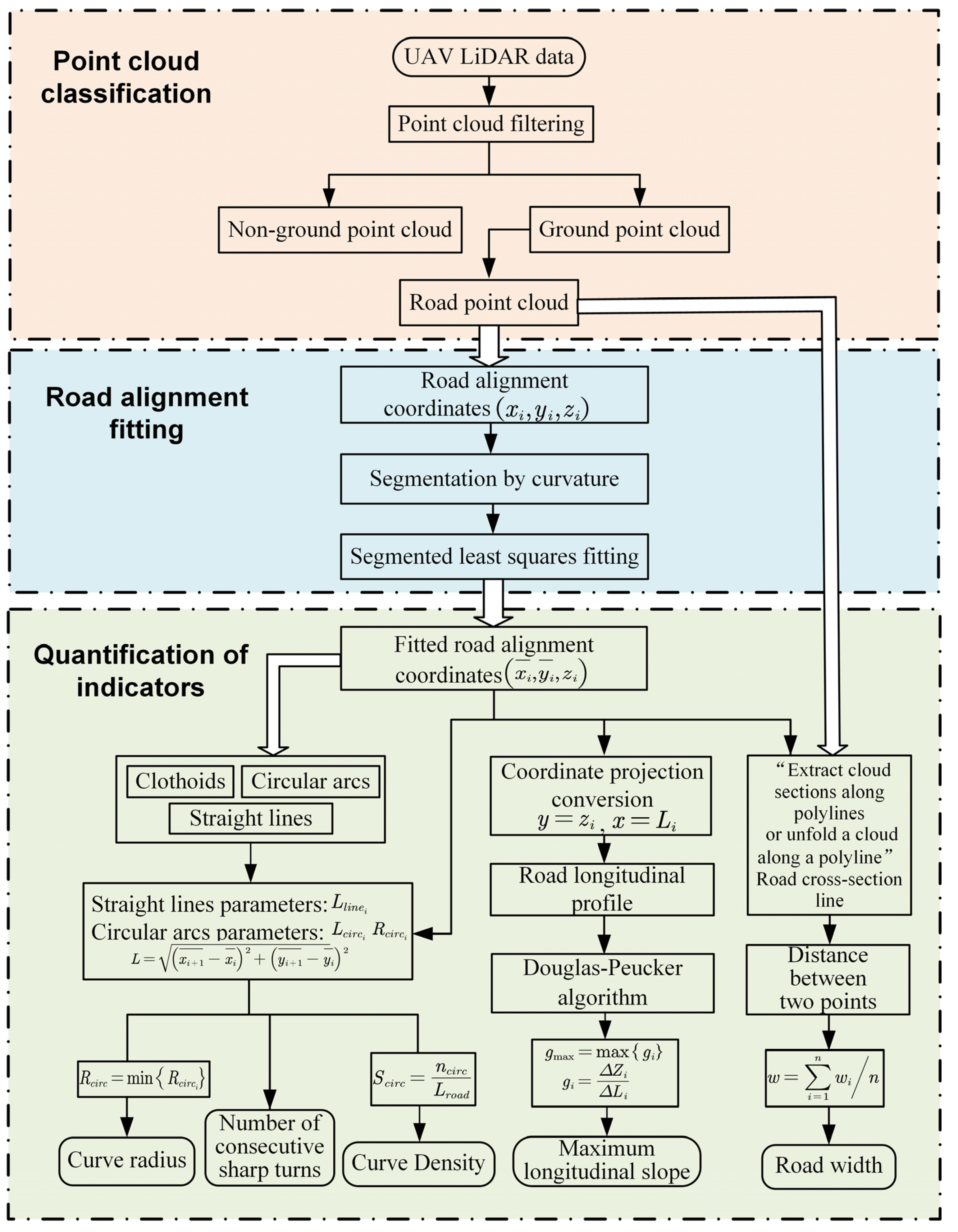
The road 3D alignment index was extracted from the aerial point cloud model (Figure 4). The road point clouds were extracted by filtering and classifying the photographed area’s point clouds. The model included both grounded and non-grounded points. The ground point clouds were filtered using the cloth simulation filter (CSF) algorithm [59]. Then, we combined the reflection intensity with the elevation information of the LiDAR to extract the road point cloud.
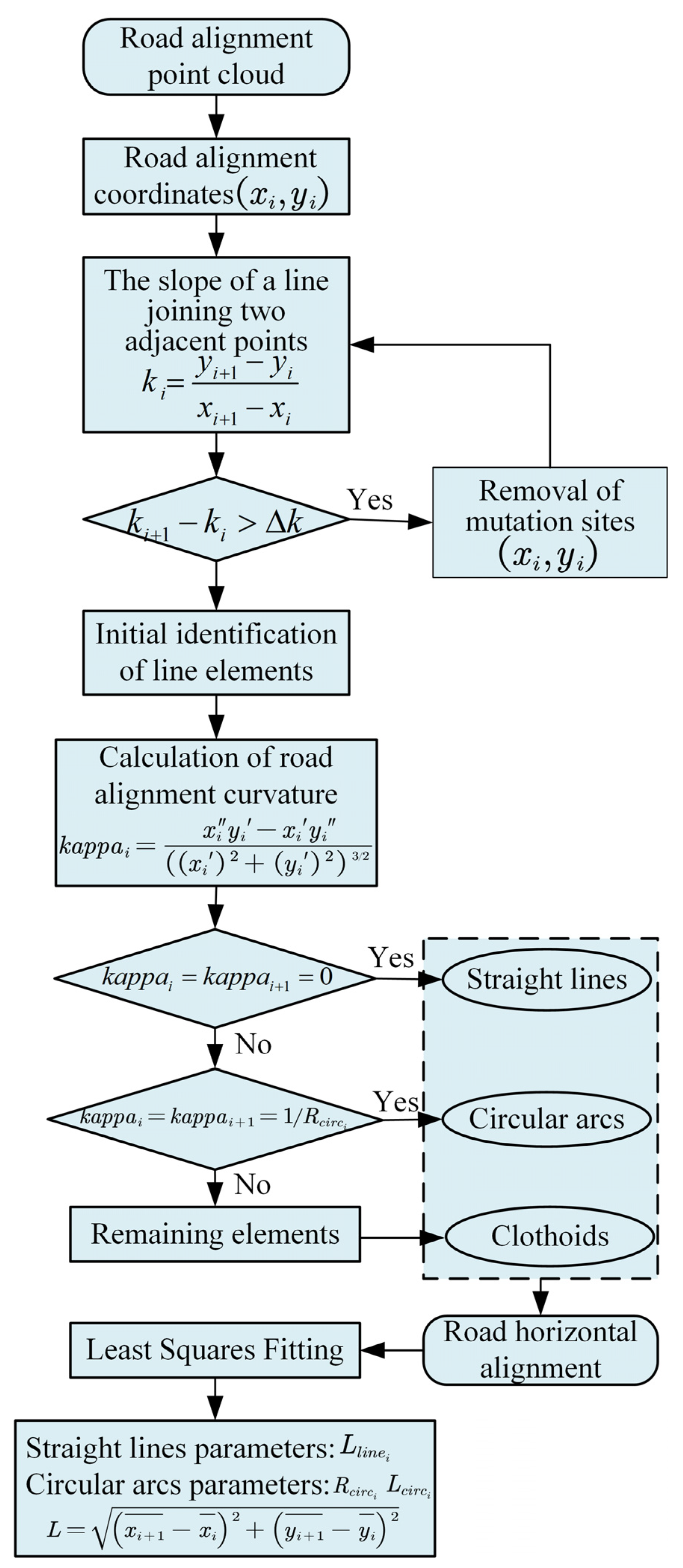
Roads are generally symmetrical to the centerline, which is the basis for road alignment. The density analysis tool in ArcGIS was used to extract the road contour, and the polygon-to-centerline function was used to extract the centerline. The road plane alignment was quickly determined. The road plane alignment comprises circular arcs, straight lines, and clothoids. Likewise, we had to classify the extracted road centerline into various line elements based on its curvature. We applied the least-squares method to eliminate the impact of measurement errors. The algorithm steps are depicted in Figure 5. The alignment point cloud  ( x i , y i ) y = f ( x ) . The line element fits the sample points as  ( X i , Y i ) , the fitted curve is noted as  Y = F X , and the fitted alignment point cloud coordinates  x ¯ i , y ¯ i y ¯ = f ( x ¯ ) .
Based on the fitting results, the minimum value of the curve radius within the segment was selected as the measurement result (Equation (1)).
R c i r c = min R c i r c i
The curve density is the ratio of the number of circular curves  n c i r c  to the alignment total length, which is the number of curves per unit length (Equations (2)–(4)).
S = n c i r c L r o a d
L = i = 1 i D k k = 1,2 , 3
D k = x i + 1 ¯ x i ¯ 2 + y i + 1 ¯ y i ¯ 2 i = 1,2 , 3
Consecutive sharp turns generally refer to a segment with three or more consecutive flat curves that are smaller than a specified radius, and the distance  L  between each curve is shorter than a specified distance. According to the Guideline for Implementation of the Highway Safety Enhancement Project, we rated the index as a grade II highway and counted the number of consecutive sharp turns.
The longitudinal slope reflects the longitudinal topographic relief. It refers to the longitudinal segment of the same slope between the two points of the height difference ( Δ Z i ) and its horizontal distance ( Δ L i ) ratio (Equations (5) and (6)).
g i = Δ Z i Δ L i × 100 %
g m a x = m a x g i
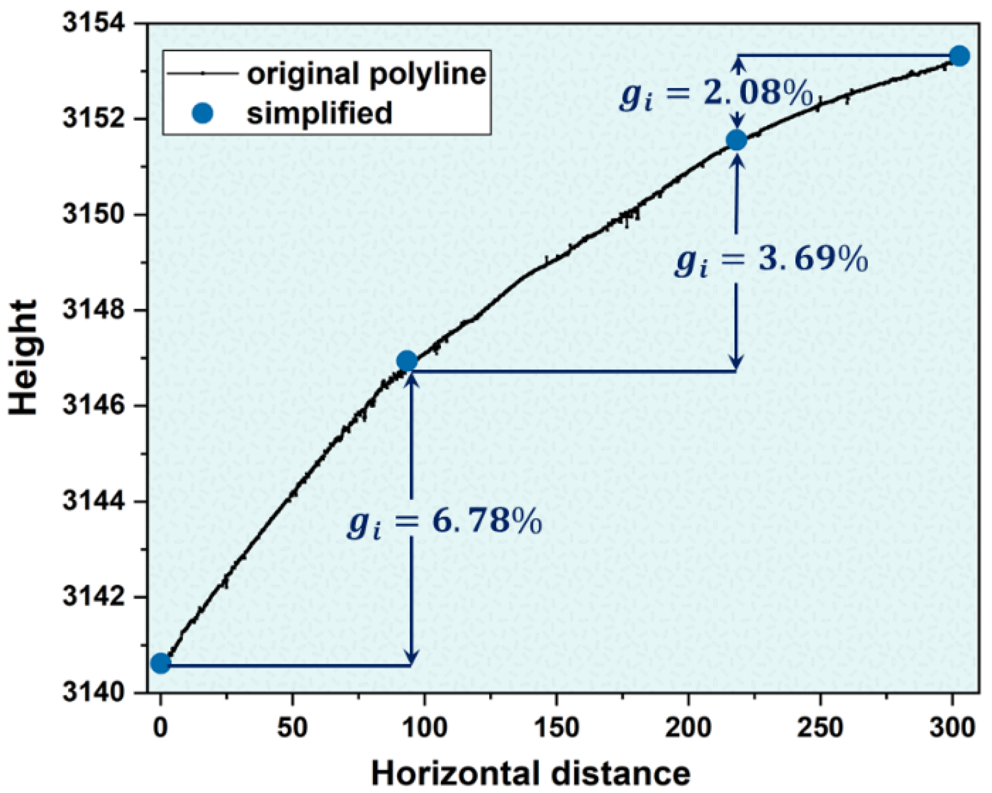
where  Z  and  L  represent the height difference and distance between the two endpoints of the same segment. The longitudinal slope requires segmenting the longitudinal section point cloud and dividing it into distinct slope sections. The Douglas–Peucker algorithm was used to segment the midline longitudinal section point cloud. It is a line simplification algorithm that can approximate the curve as a series of folded lines. It uses a small number of points to represent the general shape of the curve.
For the road width index, we used CloudCompare 2.12.4 software to measure the widths and took the average.
Environmental and disaster indices are easier to extract from the overall road safety risk assessment process. UAV collected the elevation, while the NDVI was derived from orthophoto maps using image analysis tools in ArcGIS. We obtained the average annual temperature and precipitation using the raster calculator tool. The natural disaster index was transformed from the open-source databases shown in Table 2.

4.3. Road Safety Risk Assessment Model

The scoring criteria were established based on the above model. The value of each index was assigned on a Likert scale ranging from 1 to 5; the greater the risk value, the lower the index’s safety level. Table 3 displays the index’s assessment criteria.
Each of the sixteen indices presented in Table 3 contributes differently to the level of road safety, so we needed to assign a weight to each index. Weights measure each index’s size and relative significance in the assessment process. Weighting methods such as principal component analysis (PCA) [64], expert opinions such as the analytic hierarchy process (AHP) [65], and the entropy method can be used to calculate index weights [66]. However, each method has its benefits and drawbacks, and no weighting method is foolproof.
The entropy method can assign weights based on the entropy provided by the index values and is widely utilized in various scientific disciplines [67]. We used the entropy method to determine the index weights in order to reduce the subjectivity of weight determination and simplify the safety assessment process. Then, we used the linear weighted sum method to obtain the road safety risk values.
The road safety risk value ( R m = 1 , 5 ) was divided into four categories by the “Transportation Safety Production Risk Source Classification Regulations”: Lower Risk/I, General Risk/II, Greater Risk/III, and Material Risk/IV.

5. Safety Risk Assessment Results and Analyses

5.1. Road Index Extraction Result

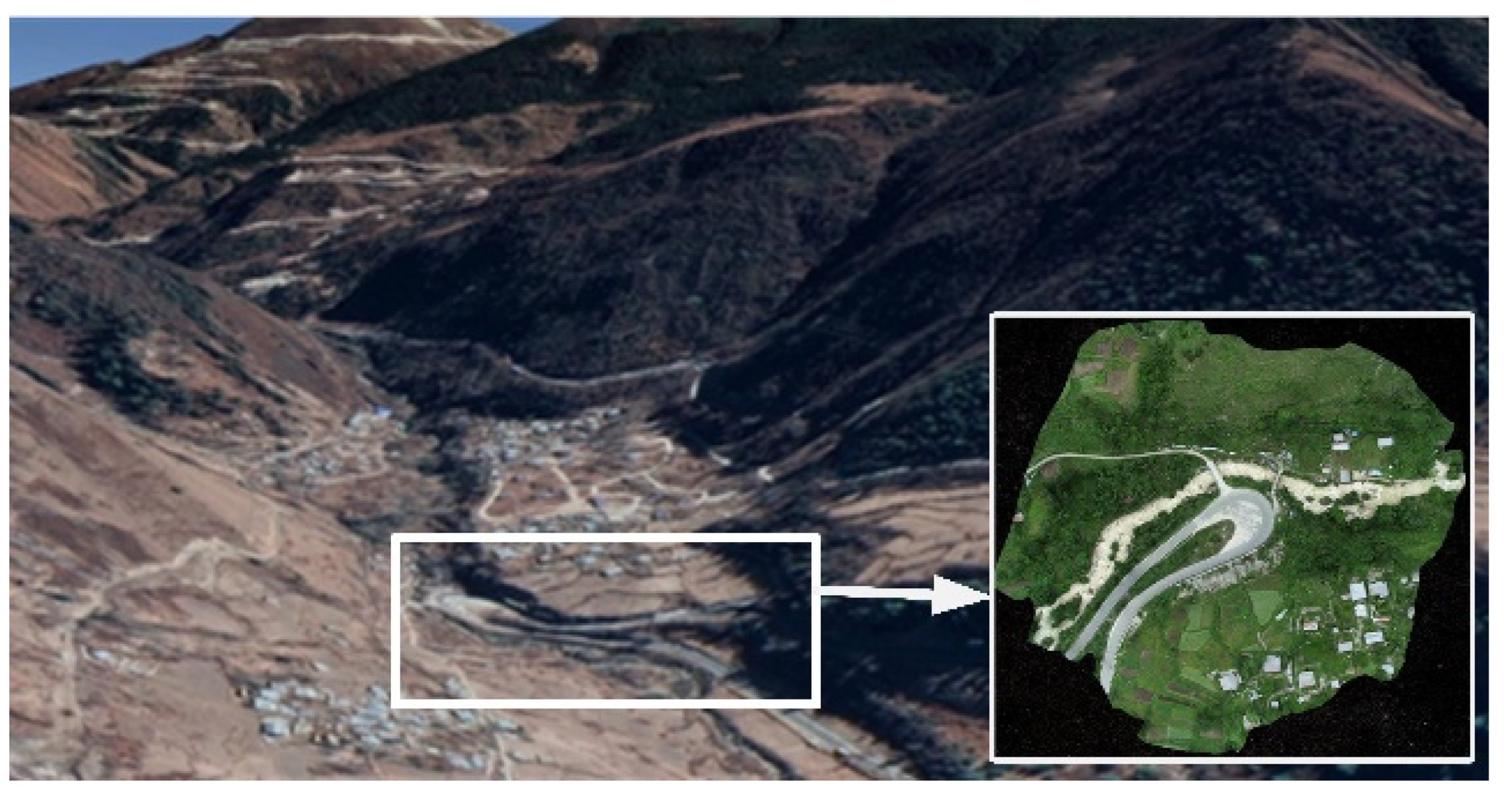
Consider Segment 2 (Figure 6) as an illustration of the above road safety risk index technical extraction procedure. Segment 2 (27.51229° N, 88.95426437° E) is between two valleys and is part of the 204 provincial highway in Yadong County, near the Chinese border. It is vulnerable to earthquakes, floods, mudslides, landslides, snowstorms, and other natural disasters.
After filtering, objects irrelevant to road safety, such as tall vegetation, high-voltage lines, and houses, were effectively removed. Following filtration, the road alignment was extracted. Verification was performed using the buffer accuracy assessment method [68] to quantify the accuracy of the extracted road median axis. The accuracy of midline extraction was as high as 88% (Table 4).
The curvature distribution and fitting results of each curve segment are shown in Figure 7.
The fitted straight-line length  L l i n e , circular arc length  L c i r c , and circular arc radius  R c i r c  are displayed in Table 5. The minimum radius of the curve is 18 m, and the road’s total length is 303.357 m. The case of the curve density is equal to 9.89 pcs/km. The distance between each circular arc exceeds the requirement of 50 m, so Segment 2 does not contain a consecutive sharp turn.
The accumulated distance and elevation create the longitudinal section of the road. The segmentation control parameter  d t h = 0.3 m , and the results are depicted in Figure 8. Segment 2 is a continuous uphill segment with an average longitudinal slope of 4.178%. The longitudinal section line is divided into three segments, with the steepest segment having a longitudinal slope of 6.779% and the slowest having a longitudinal slope of 2.084%. There is one segment with a gradient greater than 6%. Within this segment, drivers should drive cautiously and pay close attention to driving safety. The average width of the road was resolved to 7.39 m.
For the environment, the vegetation around road segment 2 is lush and covers a large area, with an NDVI value of 0.758. The average elevation of this road segment is 3148.69 m. According to the database, the area has an average annual temperature of 6.18 °C and an average annual precipitation of 438.33 mm.
For natural disasters, although the road segment is in an area with a low risk of flood, snow, and freeze–thaw disasters, it has seismic risk and a high risk of landslide mudslide. Managers should add protective nets to the road section to prevent falling rocks caused by earthquakes or landslides from impeding traffic passage or injuring vehicles and people.

5.2. Risk Assessment Results of the Study Area

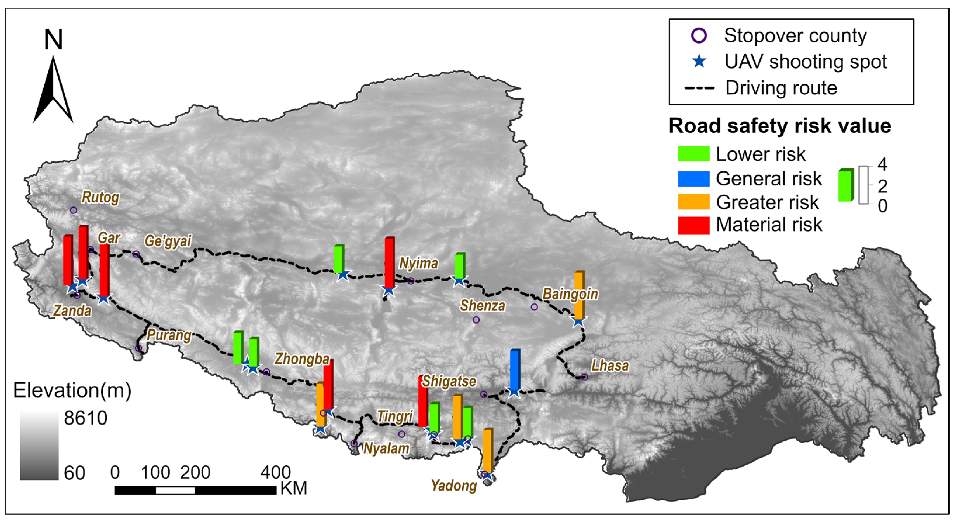
The designed multi-index extraction framework was applied to 17 road segments in Tibet. Table 6 illustrates the ranking of segments for the study area. Their road safety risk value distribution is depicted in Figure 9. Road safety auditors should determine the priority road risk sections and management measures according to the ranking order and assessment level.
The risks posed by Segments 11, 13, 6, 15, 7, and 12 were evaluated as material (Figure 10). They are all mountainous roads with generally small curves. There is a significant difference in elevation between the segments, and some of them have sparse vegetation. They are located where snow, flooding, freeze–thaw cycles, and sandstorms are likely to cause road damage.
Segments 9, 3, 5, 10, 14, and 16 were rated as less risky (Figure 11). These segments have a large radius of curvature and a slight longitudinal slope, but some are susceptible to landslides, mudslides, and freeze–thaw cycles.
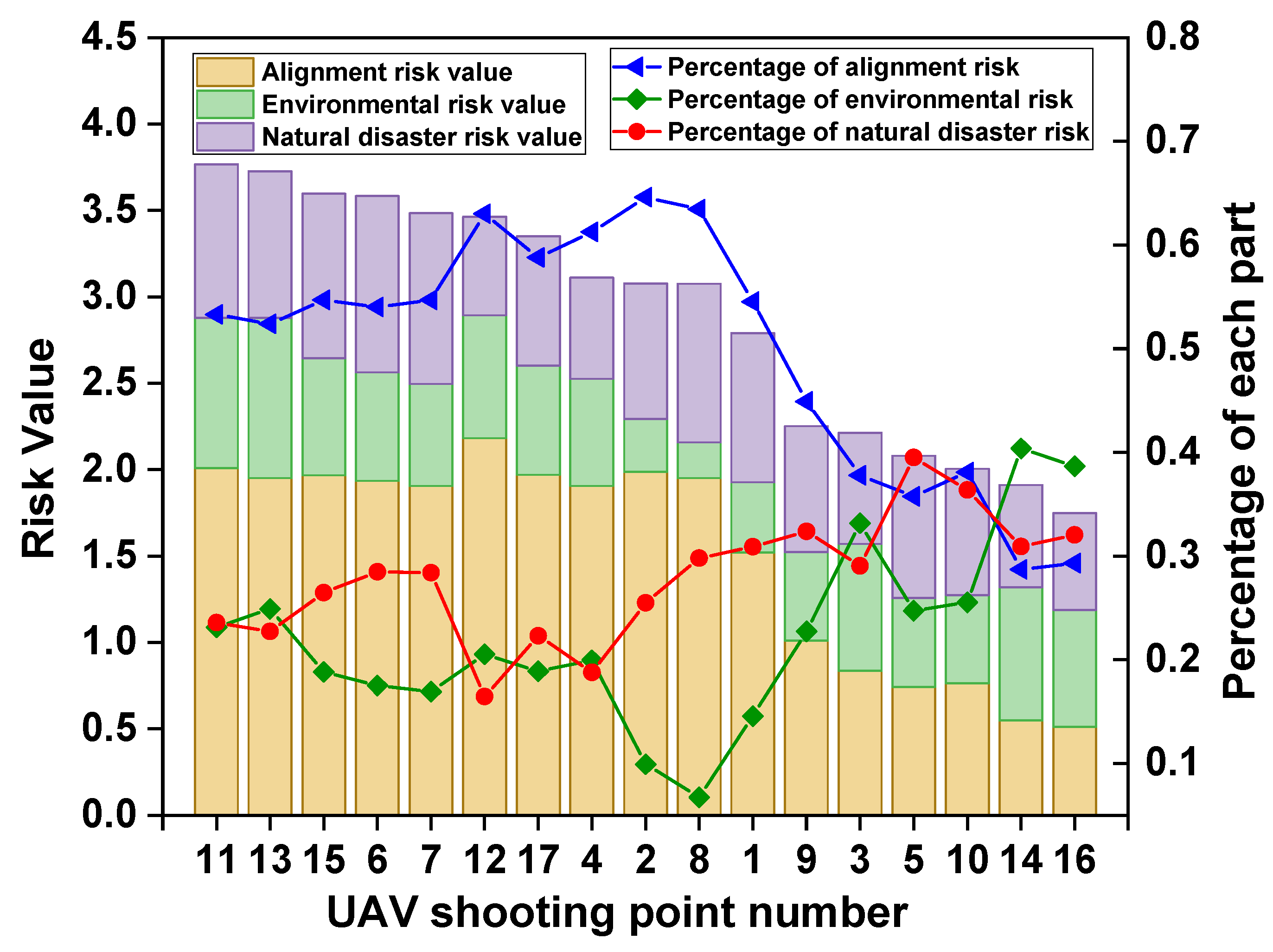
We then calculated each road segment’s index of road alignment, environment, and natural disasters as a proportion of the risk value (Figure 12).
The results indicated that alignment risk accounts for a more significant proportion of greater and material risk roads. It is distinct from environmental and disaster risks. For roads in Tibet, ensuring safe alignment is the primary objective. However, there are portions of the segments in which environmental and natural disaster risks are the primary causes. For instance, the leading cause of Segment 16’s risk is its environment (Figure 13). A steep topographic slope and the potential for falling rocks surround the road. Natural disasters in Segment 5 (Figure 13) are the primary reason for road risk. It is subject to soil sanding, and the moving dunes can bury the road.

6. Conclusions and Discussion

Highland roads, unlike urban roads, are low-volume traffic roads. Influenced by geographical factors, they often have problems such as an unreasonable road alignment design, unsafe road environments, and a lack of management data. Therefore, it is necessary to study a suitable assessment method for plateau road traffic safety. However, obtaining road safety measurements on the Tibetan Plateau is dangerous. To address these challenges, we first introduced LiDAR into road safety risk assessment and proposed a set of assessment index systems and extraction methods applicable to the plateau. The above are essential contributions to our study.
Based on the point cloud data from UAV LiDAR and open-source data, we selected seventeen road segments on the Tibetan plateau for road safety risk assessment. We analyzed different factors affecting road safety by combining special topography conditions and harsh environmental features. Finally, we integrated 3D road alignments, the environment, and natural disaster components into the method in order to build a risk assessment framework applicable to the plateau. The entropy and linear weighted sum methods were introduced in order to calculate the risk value. This value indicates the risk level and ranking order of the road segments. The framework enables the safety levels of different risky road segments to be assessed and ultimately identifies the safety of specific locations. In addition, the framework can be used to identify dangerous road segments and the main factors limiting the road system’s safety. This study helps highland road managers to manage and maintain the road infrastructure in the absence of human management resources and historical data on road traffic safety accidents. This study provides an excellent opportunity to answer key research questions: What factors influence road safety risk in the highlands? How can the safety and efficiency of road safety audits be improved in the highlands?
The specific results of the case studies are as follows: the road sections with high-risk rankings are all located in the southwestern part of the Tibet region. The high-risk road segments are mountainous roads with a small curve radius and are in areas prone to natural disasters. Low-risk road segments generally have better road alignment, but their environmental and disaster risks cannot be ignored, as they can cause accidents [22]. Observing the proportion of the three risk elements separately, we found that road alignment is more significant for the higher-risk road segments, consistent with Antonio et al.’s study [26]. For roads in Tibet, ensuring safe alignment is the primary goal. Although it is difficult to change the alignment due to the topographic constraints, we can still take measures to mitigate the risks. Road managers can establish a traffic management system on sharply curved, longitudinal slope sections, install warning/slow-down signs and vibrating belts, and regularly maintain road traffic signs and markings. Traffic safety investments should be prioritized for road sections with a small curve radius.
Although we study the Tibetan Plateau as an example, our proposed framework can be extended to other hazard-prone areas and high-altitude regions. Several extensions are anticipated in our future work. The application of UAV LiDAR to analyze road 3D data is still in its preliminary exploration stage. We can continue to expand and propose more diverse and efficient road index extraction algorithms. In addition, the construction and maintenance of transportation infrastructure in highland areas are complex and costly, so road infrastructure can also be included in the assessment system in the future.

Author Contributions

Conceptualization, Y.Z. and H.Z.; Methodology, Y.Z. and H.Z.; Software, Y.Z.; Validation, X.D., Y.X. and J.L.; Formal Analysis, Y.Z.; Investigation, Y.Z. and H.Z.; Resources, H.Z.; Data Curation, X.D. and Y.Z.; Writing—Original Draft Preparation, Y.Z., X.D. and H.Z.; Writing—Review and Editing, Y.Z., X.D., Y.X., J.L. and H.Z.; Visualization, Y.Z.; Supervision, Y.Z. and H.Z.; Project Administration, H.Z.; Funding Acquisition, Y.Z. and H.Z. All authors have read and agreed to the published version of the manuscript.

Funding

This research was supported by The Second Tibetan Plateau Scientific Expedition and Research Project (12806-212000007) and Project Supported by State Key Laboratory of Earth Surface Processes and Resource Ecology.

Data Availability Statement

Not applicable.

Conflicts of Interest

The authors declare no conflict of interest.

References

  1. Laurinavičius, A.; Grigonis, V.; Ušpalytė-Vitkūnienė, R.; Ratkevičiūtė, K.; Čygaitė, L.; Skrodenis, E.; Antov, D.; Smirnovs, J.; Bobrovaitė-Jurkonė, B. Policy Instruments for Managing EU Road Safety Targets: Road Safety Impact Assessment. Balt. J. Road Bridge Eng. 2012, 7, 60–67. [Google Scholar] [CrossRef]
  2. Grande, Z.; Castillo, E.; Mora, E.; Lo, H.K. Highway and Road Probabilistic Safety Assessment Based on Bayesian Network Models. Comput. Aided Civ. Inf. 2017, 32, 379–396. [Google Scholar] [CrossRef]
  3. Fu, B.J.; Ouyang, Z.Y.; Shi, P.; Fan, J.; Wang, X.D.; Zheng, H.; Zhao, W.W.; Wu, F. Current Condition and Protection Strategies of Qinghai-Tibet Plateau Ecological Security Barrier. Bull. Chin. Acad. Sci. 2021, 36, 1298–1306. (In Chinese) [Google Scholar]
  4. Chen, K.M.; Wang, Y.P.; Wang, H. Characteristics of main artery traffic volume. J. Chang’an Univ. (Nat. Sci. Ed.) 2003, 23, 74–78. (In Chinese) [Google Scholar]
  5. Jibin, P. Research on Highway Planning in Tibet. Master’s Thesis, Southwest Jiaotong University, Chengdu, China, 2007. (In Chinese). [Google Scholar]
  6. Hu, J.; Yang, Y. Safety of Driving Behavior on Low-Volume Roads in China. Transp. Res. Rec. J. Transp. Res. Board 2011, 2203, 100–105. [Google Scholar] [CrossRef]
  7. Yuan, Z.; Huang, D.; Tong, W.; Liu, Z. Characteristic Analysis and Prediction of Traffic Accidents in the Multiethnic Plateau Mountain Area. J. Transp. Eng. Part A Syst. 2020, 146, 04020068. [Google Scholar] [CrossRef]
  8. Shi, L.; Huseynova, N.; Yang, B.; Li, C.; Gao, L. A Cask Evaluation Model to Assess Safety in Chinese Rural Roads. Sustainability 2018, 10, 3864. [Google Scholar] [CrossRef] [Green Version]
  9. Peng, C.; FengHuan, S.U.; Qiang, Z.; NingSheng, C.; YiLi, Z. Risk assessment and disaster reduction strategies for mountainous and meteorological hazards in Tibetan Plateau. Chin. Sci. Bull. 2015, 60, 3067–3077. (In Chinese) [Google Scholar]
  10. Elyasi, M.R.; Saffarzade, M.; Boroujerdian, A.M. A novel dynamic segmentation model for identification and prioritization of black spots based on the pattern of potential for safety improvement. Transp. Res. Part A Policy Pract. 2016, 91, 346–357. [Google Scholar] [CrossRef]
  11. Coll, B.; Moutari, S.; Marshall, A.H. Hotspots identification and ranking for road safety improvement: An alternative approach. Accid. Anal. Prev. 2013, 59, 604–617. [Google Scholar] [CrossRef]
  12. Akin, D.; Sisiopiku, V.P.; Skabardonis, A. Impacts of Weather on Traffic Flow Characteristics of Urban Freeways in Istanbul. Procedia—Soc. Behav. Sci. 2011, 16, 89–99. [Google Scholar] [CrossRef] [Green Version]
  13. Ackaah, W.; Salifu, M. Crash prediction model for two-lane rural highways in the Ashanti region of Ghana. IATSS Res. 2011, 35, 34–40. [Google Scholar] [CrossRef] [Green Version]
  14. Ma, Z.; Shao, C.; Ma, S.; Ye, Z. Constructing road safety performance indicators using Fuzzy Delphi Method and Grey Delphi Method. Expert. Syst. Appl. 2011, 38, 1509–1514. [Google Scholar] [CrossRef]
  15. Chen, F.; Wang, J.; Deng, Y. Road safety risk evaluation by means of improved entropy TOPSIS–RSR. Saf. Sci. 2015, 79, 39–54. [Google Scholar] [CrossRef]
  16. Shah, S.; Brijs, T.; Ahmad, N.; Pirdavani, A.; Shen, Y.; Basheer, M. Road Safety Risk Evaluation Using GIS-Based Data Envelopment Analysis—Artificial Neural Networks Approach. Appl. Sci. 2017, 7, 886. [Google Scholar] [CrossRef] [Green Version]
  17. Wei, Z. Research on Road Safety Evaluation Based on BP Artificial Neural Network. Master’s Thesis, Chang’an University, Xi’an, China, 2006. (In Chinese). [Google Scholar]
  18. Duan, Z.; Xu, J.; Ru, H.; Li, M. Classification of Driving Fatigue in High-Altitude Areas. Sustainability 2019, 11, 817. [Google Scholar] [CrossRef] [Green Version]
  19. Wang, C.; Quddus, M.A.; Ison, S.G. The effect of traffic and road characteristics on road safety: A review and future research direction. Saf. Sci. 2013, 57, 264–275. [Google Scholar] [CrossRef]
  20. Zhong, R. Study on Risk Assessment Methods of Freeway. Master’s Thesis, Chang’an University, Xi’an, China, 2014. (In Chinese). [Google Scholar]
  21. Hu, F. Research on Key Alignment Indicators of Two-Lane Highway in Plateau Based on Drivers’ Physiological Characteristics. Master’s Thesis, Southeast University, Nanjing, China, 2020. (In Chinese). [Google Scholar]
  22. Lu, H.; Chen, M.; Kuang, W. The impacts of abnormal weather and natural disasters on transport and strategies for enhancing ability for disaster prevention and mitigation. Transp. Policy 2020, 98, 2–9. [Google Scholar] [CrossRef]
  23. Zhou, Y.; Huang, R.; Jiang, T.; Dong, Z.; Yang, B. Highway alignments extraction and 3D modeling from airborne laser scanning point clouds. Int. J. Appl. Earth Obs. 2021, 102, 102429. [Google Scholar] [CrossRef]
  24. Hu, X.; Li, Y.; Shan, J.; Zhang, J.; Zhang, Y. Road Centerline Extraction in Complex Urban Scenes From LiDAR Data Based on Multiple Features. IEEE Trans. Geosci. Remote Sens. 2014, 52, 7448–7456. [Google Scholar]
  25. Zhu, L.; Lehtomäki, M.; Hyyppä, J.; Puttonen, E.; Krooks, A.; Hyyppä, H. Automated 3D Scene Reconstruction from Open Geospatial Data Sources: Airborne Laser Scanning and a 2D Topographic Database. Remote Sens. 2015, 7, 6710–6740. [Google Scholar] [CrossRef] [Green Version]
  26. Antonio Martín-Jiménez, J.; Zazo, S.; Arranz Justel, J.J.; Rodríguez-Gonzálvez, P.; González-Aguilera, D. Road safety evaluation through automatic extraction of road horizontal alignments from Mobile LiDAR System and inductive reasoning based on a decision tree. ISPRS J. Photogramm. 2018, 146, 334–346. [Google Scholar] [CrossRef] [Green Version]
  27. Jung, J.; Olsen, M.J.; Hurwitz, D.S.; Kashani, A.G.; Buker, K. 3D virtual intersection sight distance analysis using lidar data. Transp. Res. Part C Emerg. Technol. 2018, 86, 563–579. [Google Scholar] [CrossRef]
  28. Ravi, R.; Cheng, Y.; Lin, Y.; Lin, Y.; Hasheminasab, S.M.; Zhou, T.; Flatt, J.E.; Habib, A. Lane Width Estimation in Work Zones Using LiDAR-Based Mobile Mapping Systems. IEEE Trans. Intell. Transp. Syst. 2020, 21, 5189–5212. [Google Scholar] [CrossRef]
  29. Sourav, M.A.A.; Mahedi, M.; Ceylan, H.; Kim, S.; Brooks, C.; Peshkin, D.; Dobson, R.; Brynick, M. Evaluation of Small Uncrewed Aircraft Systems Data in Airfield Pavement Crack Detection and Rating. Transp. Res. Rec. J. Transp. Res. Board 2023, 2677, 653–668. [Google Scholar] [CrossRef]
  30. Truong, L.N.H.; Mora, O.E.; Cheng, W.; Tang, H.; Singh, M. Deep Learning to Detect Road Distress from Unmanned Aerial System Imagery. Transp. Res. Rec. J. Transp. Res. Board 2021, 2675, 776–788. [Google Scholar] [CrossRef]
  31. Yilmaz, V. Automated ground filtering of LiDAR and UAS point clouds with metaheuristics. Opt. Laser Technol. 2021, 138, 106890. [Google Scholar] [CrossRef]
  32. Mohan, S.; Shoghli, O.; Burde, A.; Tabkhi, H. Low-Power Drone-Mountable Real-Time Artificial Intelligence Framework for Road Asset Classification. Transp. Res. Rec. J. Transp. Res. Board 2021, 2675, 39–48. [Google Scholar] [CrossRef]
  33. Biçici, S.; Zeybek, M. Effectiveness of Training Sample and Features for Random Forest on Road Extraction from Unmanned Aerial Vehicle-Based Point Cloud. Transp. Res. Rec. J. Transp. Res. Board 2021, 2675, 401–418. [Google Scholar] [CrossRef]
  34. Biçici, S.; Zeybek, M. Improvements on Road Centerline Extraction by Combining Voronoi Diagram and IntensityFeature from 3D UAV-based Point Cloud. In Proceedings of the International Conference on Smart City Applications: 2021, Safranbolu, Turkey, 27–29 November 2021; pp. 935–944. [Google Scholar]
  35. Hao, W. Analysis and Preventive Measures of Highway Traffic Accidents at High Altitude and High Altitude—A Case Study of Qinghai-Tibet Highway. Master’s Thesis, Chang’an University, Xi’an, China, 2017. (In Chinese). [Google Scholar]
  36. GB 18306—2015; Seismic Ground Motion Parameterszonation Map of China. National Standardization Administration of China: Beijing, China, 2015.
  37. Liu, F.; Mao, X.; Zhang, Y.; Chen, Q.; Liu, P.; Zhao, Z. Risk analysis of snow disaster in the pastoral areas of the Qinghai-Tibet Plateau. J. Geogr. Sci. 2014, 24, 411–426. [Google Scholar] [CrossRef]
  38. Luo, J.N.; Zheng, X.J.; Zhu, F.K.; Xian, D.; Yang, W.X.; Tu, Z.F.; Li, M.X. Meteorologically Dangerous Level of Dust Storm Occurrence in China. J. Desert Res. 2011, 31, 185–190. (In Chinese) [Google Scholar]
  39. Dong, W. Risk Analysis and Zoning of Highway Flood Disasters. Master’s Thesis, Chang’an University, Xi’an, China, 2013. (In Chinese). [Google Scholar]
  40. Luo, H.S.; Xu, L.J.; Du, Z.G.; Wang, Z.J. Research on influence of multi-frequency visual reference system on speed perception on ice and snow curve. China Saf. Sci. J. 2019, 29, 100–105. (In Chinese) [Google Scholar]
  41. Bu, P.; Yong, D. Shallow to discuss road line shape design the impact on traffic safety. Tibet Sci. Technol. 2008, 57–59, 73. (In Chinese) [Google Scholar]
  42. Wei, Y.Q. Affect against Traffic Safety by Road Conditions. Master’s Thesis, Beijing University of Technology, Beijing, China, 2004. (In Chinese). [Google Scholar]
  43. Kronprasert, N.; Boontan, K.; Kanha, P. Crash Prediction Models for Horizontal Curve Segments on Two-Lane Rural Roads in Thailand. Sustainbility 2021, 13, 9011. [Google Scholar] [CrossRef]
  44. Wu, L.; Sun, J.; Li, T. Relationship between Lane Width and Safety along Urban Expressways in Shanghai. J. Transp. Eng. Part A Syst. 2019, 145, 5018004. [Google Scholar] [CrossRef]
  45. Aimin, S. Research on the Freeway Traffic Accidents and Countermeasures. Master’s Thesis, Southeast University, Nanjing, China, 2006. (In Chinese). [Google Scholar]
  46. Li, C.; Ding, L.; Fang, Q.; Chen, K.; Castro-Lacouture, D. Risk-informed knowledge-based design for road infrastructure in an extreme environment. Knowl. Syst. 2021, 216, 106741. [Google Scholar] [CrossRef]
  47. Keay, K.; Simmonds, I. The association of rainfall and other weather variables with road traffic volume in Melbourne, Australia. Accid. Anal. Prev. 2005, 37, 109–124. [Google Scholar] [CrossRef]
  48. Dell Acqua, G.; De Luca, M.; Mauro, R.; Russo, F. Freeway Crashes in Wet Weather: The Comparative Influence of Porous and Conventional Asphalt Surfacing. Procedia—Soc. Behav. Sci. 2012, 54, 618–627. [Google Scholar] [CrossRef] [Green Version]
  49. Lansheng, Z.; Peijun, S.; Jingai, W.; Li, Z. Regionalization of natural disasters in China. J. Beijing Norm. Univ. Nat. Sci. 1995, 31, 415–421. Available online: https://kns.cnki.net/kcms2/article/abstract?v=3uoqIhG8C44YLTlOAiTRKjkpgKvIT9NkGsvn6cq9Bo0A1Fqk5ji9ArT60TC_cFTxbQHC-MZG4C9nOpujg81TIBOVTA-UpIrt&uniplatform=NZKPT (accessed on 4 June 2023). (In Chinese).
  50. Cioca, L.; Ivascu, L. Risk Indicators and Road Accident Analysis for the Period 2012–2016. Sustainbility 2017, 9, 1530. [Google Scholar] [CrossRef] [Green Version]
  51. Zhao, G.H. Reasearch on Guideline for Implementation of Rural Roads Safety Enhancement Project in Mountain Area. Master’s Thesis, Chongqing Jiaotong University, Chongqing, China, 2012. (In Chinese). [Google Scholar]
  52. Zhang, H.; Zhang, M.; Zhang, C.; Hou, L. Formulating a GIS-based geometric design quality assessment model for Mountain highways. Accid. Anal. Prev. 2021, 157, 106172. [Google Scholar] [CrossRef] [PubMed]
  53. Bono, F.; Gutiérrez, E. A network-based analysis of the impact of structural damage on urban accessibility following a disaster: The case of the seismically damaged Port Au Prince and Carrefour urban road networks. J. Transp. Geogr. 2011, 19, 1443–1455. [Google Scholar] [CrossRef]
  54. Wei, R.; Zeng, Q.; Davies, T.; Yuan, G.; Wang, K.; Xue, X.; Yin, Q. Geohazard cascade and mechanism of large debris flows in Tianmo gully, SE Tibetan Plateau and implications to hazard monitoring. Eng. Geol. 2018, 233, 172–182. [Google Scholar] [CrossRef]
  55. Mosavi, A.; Shirzadi, A.; Choubin, B.; Taromideh, F.; Hosseini, F.S.; Borji, M.; Shahabi, H.; Salvati, A.; Dineva, A.A. Towards an Ensemble Machine Learning Model of Random Subspace Based Functional Tree Classifier for Snow Avalanche Susceptibility Mapping. IEEE Access 2020, 8, 145968–145983. [Google Scholar] [CrossRef]
  56. Reinolsmann, N.; Alhajyaseen, W.; Brijs, T.; Pirdavani, A.; Hussain, Q.; Brijs, K. Sandstorm animations on rural expressways: The impact of variable message sign strategies on driver behavior in low visibility conditions. Transp. Res. Part F Traffic Psychol. Behav. 2021, 78, 308–325. [Google Scholar] [CrossRef]
  57. Singh, P.; Sinha, V.S.P.; Vijhani, A.; Pahuja, N. Vulnerability assessment of urban road network from urban flood. Int. J. Disaster Risk Reduct. 2018, 28, 237–250. [Google Scholar] [CrossRef]
  58. Gordon, C.; Ping, H. Linearity Engineering in Permafrost Areas. J. Glaciol. Geocryol. 2001, 23, 213–217. (In Chinese) [Google Scholar]
  59. Zhang, W.; Qi, J.; Wan, P.; Wang, H.; Xie, D.; Wang, X.; Yan, G. An Easy-to-Use Airborne LiDAR Data Filtering Method Based on Cloth Simulation. Remote Sens. 2016, 8, 501. [Google Scholar] [CrossRef]
  60. JTG D20-2017; Design Specification for Highway Alignment. Ministry of Transportation of the People’s Republic of China: Beijing, China, 2017.
  61. Tao, G. Rural Highway Typical Simulation Evaluation of Road Traffic Safety and Security Countermeasure Research. Master’s Thesis, Chang’an University, Xi’an, China, 2015. (In Chinese). [Google Scholar]
  62. JTG B01 2003; Technical Standard of Highway Engineering. Ministry of Transportation of the People’s Republic of China: Beijing, China, 2003.
  63. Xu, C.; Xu, X.W.; Yu, G.H.; Wu, X.Y. Susceptibility Analysis of Impact Factors of Landslides Triggered by Yushu Earthquake. Sci. Technol. Rev. 2012, 30, 18–24. (In Chinese) [Google Scholar]
  64. Wegman, F.; Oppe, S. Benchmarking road safety performances of countries. Saf. Sci. 2010, 48, 1203–1211. [Google Scholar] [CrossRef]
  65. Saaty, R.W. The analytic hierarchy process—What it is and how it is used. Math. Model. 1987, 9, 161–176. [Google Scholar] [CrossRef] [Green Version]
  66. Shannon, C.E. The mathematical theory of communication. Bell Syst. Tech. J. 1948, 27, 379–423+623–656. [Google Scholar] [CrossRef] [Green Version]
  67. Ngoduy, D.; Maher, M.J. Calibration of second order traffic models using continuous cross entropy method. Transp. Res. Part C Emerg. Technol. 2012, 24, 102–121. [Google Scholar] [CrossRef]
  68. TVEITE, H. An accuracy assessment method for geographical line data sets based on buffering. Int. J. Geogr. Inf. Sci. IJGIS 1999, 13, 27–47. [Google Scholar] [CrossRef]
Figure 1. Tibetan road network and sample point.
Sustainability 15 11443 g001
Figure 2. Examples of hazards around roads.
Sustainability 15 11443 g002
Figure 3. Traffic accidents in Tibet (2011~2020).
Sustainability 15 11443 g003
Figure 4. Road alignment index extraction process.
Sustainability 15 11443 g004
Figure 5. Road alignment fitting process.
Sustainability 15 11443 g005
Figure 6. Location and scanning model of road Segment 2.
Sustainability 15 11443 g006
Figure 7. Curvature distribution of road alignment and its fitting results.
Sustainability 15 11443 g007
Figure 8. Road longitudinal slope of Segment 2.
Sustainability 15 11443 g008
Figure 9. Road safety risk value distribution.
Sustainability 15 11443 g009
Figure 10. Point cloud reconstruction models of material risk segments and their actual surroundings.
Sustainability 15 11443 g010
Figure 11. Point cloud reconstruction models of lower risk segments and their actual surroundings.
Sustainability 15 11443 g011
Figure 12. Ranking of road safety risk values and calculation of the percentage of each part according to risk category.
Sustainability 15 11443 g012
Figure 13. Point cloud reconstruction models of Segment 16 and Segment 5 and their actual surroundings.
Sustainability 15 11443 g013
Table 1. Environmental data source.
Data TypeData Source
Average annual temperature
Average annual precipitation
DING mingjun. Grid data of annual temperature and annual precipitation on the Tibetan Plateau and its surrounding areas during 1998–2017. National Tibetan Plateau Data Center.
Seismic riskGB18306—2015 Seismic ground motion parameters zonation map of China [36]
Landslide collapse, mudslide riskTibetan Plateau Scientific Research Database
Snowstorm risk[37]
Sandstorm risk[38]
Flood risk[39]
Freeze–thaw riskTibetan Plateau Scientific Research Database
Table 2. Road safety assessment indices.
Road Safety Risk IndexLiterature BasisData Source
Road 3D alignmentCurve radius  R c i r c  (m)[16,50]LiDAR road point cloud
Curve density  S c i r c  (pcs/km)[41]
Number of consecutive sharp turns  n s t    (pcs)[51]
Maximum longitudinal slope  g m a x  (%)[52]
Road width  w  (m)[44]
EnvironmentNormalized Difference Vegetation Index  N D V I  [46]UAV orthophoto
Elevation  H  (m)[18]road point cloud
Average annual temperature  T e m  (°C)[12]National Tibetan Plateau Data Center
Average annual precipitation  P r e  (mm)[47,48]
Natural DisastersEarthquake[53][36]
Landslide collapse, mudslide[54]Research Database
Snowstorm[55][37]
Sandstorm[56][38]
flood[57][39]
Freeze–thaw[58]Research Database
Table 3. Quantification of indices.
Risk Value12345Basis
Curve radius  R c i r c  (m)   R c 200   100 R c < 200   65 R c < 100   30 R c < 65   R c < 30 [60]
Curve density  S c i r c  (pcs/km)   S < 3   3 S < 5   5 S < 10   10 S < 20   S 20 [41]
Number of consecutive sharp turns  n s t  (pcs)   n = 0   1 n < 2   2 n < 3   3 n < 4   n 4 [61]
Maximum longitudinal slope  g m a x  (%)   i < 3   3 i < 4   4 i < 5   5 i < 6   i 6 [62]
Road width  w  (m)   7.5 b < 15   7 b < 7.5   6.5 b < 7   6 b < 6.5   b < 6   o r   b 15 [60]
Normalized difference vegetation index  N D V I     N D V I 0.5   0.4 N D V I < 0.5   0.35 N D V I < 0.4   0.3 N D V I < 0.35   0.2 N D V I < 0.3 [63]
Elevation  H  (m)   3000 H < 4000   4000 H < 4500   4500 H < 5000   5000 H < 5500   H 5500 [18]
Average annual temperature  T e m  (°C)   7 A n n < 35   4 A n n < 7   2 A n n < 4   0 A n n < 2   A n n < 0   o r   A n n 35 [12]
Average annual precipitation  P r e  (mm)   P r e 500   400 P r e < 500   300 P r e < 400   200 P r e < 300   P r e < 200 [48]
Earthquake acceleration  a m a x  (g)   a m a x = 0.05   a m a x = 0.1   o r   a m a x = 0.15   a m a x = 0.2   o r   a m a x = 0.3   a m a x = 0.4   a m a x > 0.4 [36]
Landslide collapse, mudslide riskLevel 0Level 1Level 2Level 3Level 4Research Database
Snowstorm riskLowestLowMediumMid-highHighest[37]
Sandstorm riskNoneLevel 0Level 1Level 2Level 3[38]
Flood riskLevel 1Level 2Level 3Level 4 [39]
Freeze–thaw riskNon-erosionSlightMildModerateStrongResearch Database
Table 4. Quantitative evaluation of the extracted alignments.
  W b  (cm) Correctness %Completeness %
2574.96773.842
3078.91377.761
3588.09486.876
Table 5. The parameters of Segment 2.
CategoryPile NumberParameters
Straight lineBP:K0 + 000~ZY:K0 + 018.797   L l i n e = 18.7971
Circular arcZY:K0 + 018.797~ YH:K0 + 040.439   L c i r c = 21.6419  
R c i r c = 250
ClothoidYH:K0 + 040.439~HZ:K0 + 065.005
Straight lineHZ:K0 + 065.005~ZH:K0 + 108.069   L l i n e = 43.0642
ClothoidZH:K0 + 108.069~HY:K0 + 141.927
Circular arcHY:K0 + 141.927~YH:K0 + 168.981   L c i r c = 27.0536  
R c i r c = 18
ClothoidYH:K0 + 168.981~HZ:K0 + 204.870
Straight lineHZ:K0 + 204.870~ZH:K0 + 231.055   L l i n e = 26.1859
ClothoidZH:K0 + 231.055~HY:K0 + 270.544
Circular arcHY:K0 + 270.544~YZ:K0 + 300.528   L c i r c = 29.9841  
R c i r c = 85
Straight lineYZ:K0 + 300.528~EP:K0 + 303.357   L l i n e = 2.8289
Table 6. Ranking of segments based on assessment results.
County NameSegment NumberRRankAssessment Result
Namling12.79 7General Risk/II
Yadong23.07 9Greater Risk/III
Kamba32.21 5Lower Risk/I
43.11 10Greater Risk/III
Dinggye52.08 4Lower Risk/I
63.58 14Material Risk/IV
Gyirong73.48 13Material Risk/IV
83.07 8Greater Risk/III
Zhongba92.25 6Lower Risk/I
102.00 3Lower Risk/I
Gar113.77 17Material Risk/IV
Zanda123.46 12Material Risk/IV
133.73 16Material Risk/IV
Nyima141.91 2Lower Risk/I
153.60 15Material Risk/IV
Shenza161.75 1Lower Risk/I
Baingoin173.35 11Greater Risk/III
Note: Classification by natural breakpoint method (Lower Risk/I:  1 R m 2.26 ; General Risk/II:  2.26 < R m 2.79 ; Greater Risk/III:  2.79 < R m 3.35 ; Material Risk/IV:  3.35 < R m 5 ).
Disclaimer/Publisher’s Note: The statements, opinions and data contained in all publications are solely those of the individual author(s) and contributor(s) and not of MDPI and/or the editor(s). MDPI and/or the editor(s) disclaim responsibility for any injury to people or property resulting from any ideas, methods, instructions or products referred to in the content.