Article

An Integrated Approach to Sub-Surface Water Pathways for the Sustainable Development of the Architectural Landscape of Agro-Urban Areas

by
Alessandra Como
,
Albina Cuomo
and
Luisa Smeragliuolo Perrotta
*
Department of Civil Engineering, University of Salerno, 84084 Fisciano, Italy
*
Author to whom correspondence should be addressed.
Sustainability 2023, 15(12), 9208; https://doi.org/10.3390/su15129208
Submission received: 15 April 2023 / Revised: 1 June 2023 / Accepted: 5 June 2023 / Published: 7 June 2023

Abstract

:
This paper presents the results of multidisciplinary research which addresses the issue of sustainability within the design of urban agricultural landscapes through the joint solution of architecture and hydro-geomorphology for the management, accessibility and use of urban agricultural landscapes. If the traditional separation between urban and productive land has now been overcome by the inclusion of agricultural areas within the cities, what is still under discussion is how to make its planning sustainable, especially in densely urbanized contexts. This research was developed with a methodology able to combine different types of data in order to satisfy needs relating to the availability of water for land supply and to make this landscape—both rural and urban—accessible to the city. Historical traces, interpretative insights, and hydro-geomorphological reading models of the territory were analysed. Their interweaving has made it possible to develop a prototype of a water and landscape infrastructure that combines a system for subsurface water, cycle–pedestrian paths and small-scale architecture features around the water tanks. The research has been tested in the city of Pozzuoli (NA) in Southern Italy, within the Monteruscello neighbourhood. The result led to a design solution of an integrated system which contributes to implementing the green transition within cities.

1. Introduction

The research work forms part of the debate on the planning of agricultural productive spaces within the city [1,2]. If a traditional city is composed of an urban space as opposed to the countryside, which is a productive space, this model is challenged today by the diffuse city and the phenomenon of urban sprawl. Campaigns have promoted healthy eating globally and the use of products of known provenance, grown within a certain radius and harvested and brought to the consumer within a specified time. This has increased the need for cities to equip themselves with green and productive spaces, and as a consequence, urban agriculture has disrupted the urban agendas of major cities [3]. Several theoretical works such as those by Pierre Donadieu or those within the Landscape Urbanism movement, as well as certain landscape projects by architects such as Desvigne and Dalnoky, are particularly significant for the subject, which has now become central in the contemporary debate on the landscape and the city [4,5,6].
What remains an open issue today is how to make the increase in green spaces in urban areas truly sustainable, especially in heavily urbanized settings. The design of these landscapes combines sustainable and urban issues, examining how they can bring quality to public space and to the city in general [7,8]. Common to many cities is the presence of voids and fragmented areas within dense urban fabrics which could potentially be transformed into urban agriculture and, at the same time, used for urban purposes in order to be reconnected to the city [9,10].
Therefore, there is a need to no longer read the topic from a monodisciplinary point of view but rather to rediscover it in the complexity of contemporary needs, through shared ways which integrate urban and landscape issues; in other words, there is a need to view the territory as a resource and to interpret its potentials starting from its natural components.
In this context, the use of big data and technologies in relation to urban analysis and planning is becoming an essential tool for prefiguring sustainability scenarios [11,12]. At the same time, there is a need to manage the complexity of data and integrate it into the more traditional techniques of urban planning, connecting it to architectural and landscape design.
This paper addresses the issue of constructing a methodology for the integration of traditional tools to analyse the city using big data and a multidisciplinary approach in order to identify sustainable solutions for the integration of an agricultural landscape within the city [13,14].
The study found a specific field of application in the territory of Monteruscello, a satellite district in the municipality of Pozzuoli in Southern Italy built in the 1980s. Here, in spite of intense building activity, there are fragmented empty areas which have escaped urbanization and have been the subject of a design experiment through the European Urban Innovative Action programme. The project aimed at transforming these into an intensive agricultural landscape as an action against urban poverty in the neighbourhood [15,16,17,18]. The project provided an opportunity to test an integrated vision through which, according to the project goals, agriculture and its related water supply must be integrated into the urban environment; therefore, landscape re-construction will be both agricultural and urban.

2. Materials and Methods
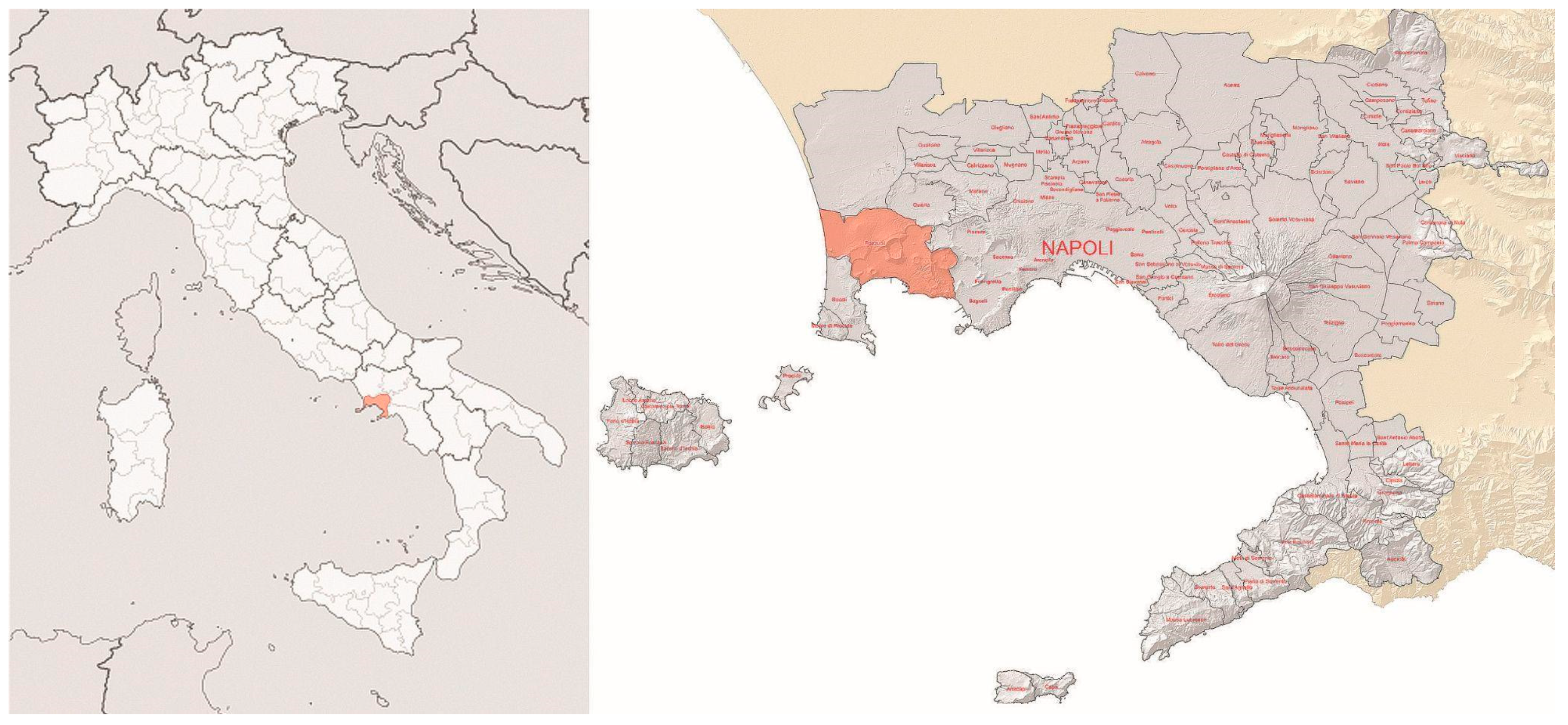
2.1. Study Area

The experimentation was conducted in Pozzuoli (NA) in Southern Italy, within the Monteruscello district characterized by 50 ha of empty areas dislocated in a fragmented manner between residential buildings. Due to the bradyseism events of 1983, around 20,000 inhabitants from the high-risk historic city of Pozzuoli were relocated to the new district of Monteruscello. This action represented the most significant urban expansion for the municipality, realizing a contemporary ‘new town’, 5 km to the north of the city centre [19].

2.1.1. Geological and Hydrogeological Setting

The selected site for the Monteruscello district was an area of agricultural land with some rural constructions, located in Southern Italy on the periphery of the city of Pozzuoli (Naples) [15].
The area encompassed a sloping terrain along the north-western volcanic site of the Phlegraean Fields, historically characterized by cultivations, the so-called ancient “Campania Felix” landscape.
From a geological and geomorphological point of view, the study area is located along the north-western side of the Phlegraean Fields, where Quaternary undifferentiated colluvial pyroclastic deposits create downslope thickening covering the pre-caldera Monteruscello volcanic products, the post-caldera yellow tufa of the Gauro crater and the Fondo Riccio spatter cone [20,21]. Besides the north-verging groundwater circulation in the deep, multi-layered volcanic aquifers [22] shallow and seasonal aquifers are located in the air fall and colluvial pyroclastic deposits in buried hollows and channels. Following the “Soil Map” of Naples Province [23], Vitric Andosols and Molli-Vitric Andosols are present as topsoils and subsoils, respectively (Figure 1).

2.1.2. Urban and Architectural Setting

Monteruscello was designed by a team of architects and professors of the University of Naples “Federico II”, with architect Agostino Renna being responsible for the design project [19,20,21,22,23,24] (Figure 2). Renna defined the layout of the district using «a simple and regular geometry, in which the repetition of an urban module leads to a logical order that controls the numerous parts and the elements» [19]. The design is based on the morphological study of an urban development with public and residential buildings, as well as pedestrian paths, streets and larger roads that connect it with the other boroughs within the city of Pozzuoli.
The neighbourhood, detached and some distance from the old town, had difficulty in creating its own identity, and its inhabitants never recognized themselves in the new city [26].
Monteruscello is now a large public housing district characterized by large and unused voids. These are the areas left unfinished from the urban design of the 1980s. Some of them have never been transformed, as the design project by Renna has never been completed for economic reasons; this is the case as regards the large archaeological park and other green and enclosed area with which the city does not come into contact.
The project is based on a transformation process that involves the abandoned green areas; they posed a difficulty for the municipality management due to their considerable size and were no longer accessible to the citizens due to overgrown vegetation. The project transforms the abandoned areas into agricultural land and gives the inhabitants the opportunity to experience the spaces through pedestrian and bike paths which traverse the new agro-urban landscape (Figure 3).

2.2. Multilayers Approach

The contemporary city forces us to deal with urban situations of great complexity [27,28]. The difficulty of working in the city today is even more evident in the suburbs and in suburban areas where the relationships that characterize the more consolidated urban fabrics are lacking [29]. In these conditions, the work of the project, rather than directly bringing order, must start from an understanding of reality. The coexistence of multiple scales, the overlapping of infrastructure networks and the neglected condition of buildings are just some of the aspects that congest the contemporary city [30]. Knowing how to sort out the criticalities of the urban fabric into distinguishable themes and analysing them independently allows one to enter into the complexity of reality in order to find a way of understanding it and guiding transformation processes capable of intersecting the information and finding an answer within the project [31,32,33].
The research developed the methodology of a multi-layered approach in which the complexity of the existing condition is disaggregated into themes, offering a range of information of different characters. The methodology viewed the city while overlapping multilayers, each of which addressed a specific theme. Like copy paper, on which a word is written and remains on the next blank page, each layer provides a trace of reference to guide the design choices.
Architectural design based on the intersection of traces has been widespread since the design experiments of overlapping historical-identity signs in Peter Eisenman’s project relating to a plaza in Cannaregio in Venice in 1978 [34] and in the intersection of the layers/grids of paths, green spaces and uses in the Cinegram Folie, which constituted Bernard Tschumi’s design for the Parc De La Villette in Paris [35] in 1988. In Chora Work [36], the text alongside the project for the gardens of the Parc De La Villette, which was realized in a dialogue with the French philosopher Jacques Derrida in 1988, Peter Eisenman describes the use of traces as a tool which challenges the traditional centrality of the form–ground pair relationship by allowing it to fluctuate between different places, times and scales [36].
Starting from these experiences of traces and their instrumental use in architectural and urban design, a reflection was constructed in which traces could be significant for the Monteruscello project and for its transformation of the abandoned green spaces.
The research started from an understanding of the neighbourhood transformation project that was carried out in the 1980s. This project, defined for years as one of the last opportunities for New Towns in Europe, was a remarkable field of experimentation, a great example of collective planning entrusted to a public research body [19,37,38,39].
Today, the traces of these places, as they were before the great urbanization, resurface within the complexities of the contemporary city, underlining the rural nature of the places and the agrarian landscape that characterized them [40,41].
The study was based on the analysis of various traces:
-
Perceptual, such as the study of visual relationships;
-
Interpretative, such as connections, existing infrastructure systems and uses of space;
-
Geomorphological, relating to the shape of the territory and its hydro-geomorphological structure;
-
Historical, the subject of new interpretations and critical redesigns based on existing analyses and on the inspections carried out. Part of the analysis was also determined through the collection of data from online resources.
The multilayer approach made it possible to identify different themes that characterize the territory. The final design will combine all the layers through a selective and critical study.

2.3. Data Collection

The organization of layers is based on different topics. Each topic is associated with a group of data, sketched in diagrammatic drawings, mainly plans. The diagrammatic design highlights certain issues in a synthetic way [42]. The collection of information creates a common database.
The data come from a variety of sources. Part of the data research was carried out at the Civil Protection Archive in Rome, where the original documents of the design project and the surveys of the urban condition before urbanization were found.
Traces of ancient settlements in the area were found through document consultation at the offices of the Superintendence of Archaeology, Fine Arts and Landscape for the Metropolitan Area of Naples in Pozzuoli.
Bibliographic research was carried out. Through this, it was possible to trace the summary reports published by Federico II University. These notebooks not only describe the design project but also collect the analyses and depict the places before construction [19,25,26,43,44,45,46].
Information and data related to urban policies and urban regeneration initiatives were collected at the Urban Authority’s planning office [47,48]. Through the Municipality, it was then possible to have a dialogue with stakeholders—mainly local associations—interested in the area developments. Part of the data was also collected through surveys, when the territory was traversed and analysed through photographs, redrawings, sketches and measuring instruments (Figure 4 and Figure 5).
This informative material was then integrated with big data from different sources. Some of these have involved, for example, the fields of geology and geomorphology, with first reliefs on topographic maps, verified later in a GIS environment. The information takes into account shapes, lithologies and hydrographic layouts still found in the urbanized environment of Monteruscello.
Briefly, the materials organized through the data collection can be catalogued in four macro-categories: urban policies, stakeholder feedback, surveys and historical maps.
The urban policies category includes:
-
The Urban Development (PRG) plan, in other words, the land planning approved by the Municipality in 2002;
-
The urban regeneration of the neighbourhood strategies by the Urban Authority’s office divided into the initiatives already completed, in progress and just planned and recorded within Urban Authority’s internal reports;
-
The landscape map of the “Phlegraean Fields”, dated 1999, the preliminary plan to the Regional Landscape Plan (PPR), dated 2019, and the plan for the protection of the “Natura 2000 areas”, preliminary to the territorial structural plan of the Phlegraean Fields regional park.
The stakeholder feedback category includes:
-
The proposal for a cycle path by the local association “Percorsi Cumani”.
-
The surveys category includes:
-
A hydraulic survey with in situ measurements of natural paths in order to understand the nature of the waters [49];
-
A geomorphological survey concerning the mapping of natural and artificial elements currently present in the areas, including the mapping of the hydrographic network and layout;
-
An urban and architectural survey that studied the areas and connections with the neighbourhood within the existing urban system.
-
The historical maps category includes:
-
The hypothesis of Roman routes that traversed the territory, postulated in 1985 [19,20,21,22,23,24,25,26,27,28,29,30,31,32,33,34,35,36,37,38,39,40,41,42,43,44,45];
-
The drawings of the neighbourhood project realized by the architect and professor Agostino Renna, responsible for the layout in 1985 [19,24,37,38,39];
-
Land use maps with descriptions of existing cultivation. In particular, two versions were found, one within the undated project documentation and another relating to the municipal PRG Plan of 1982 (Civil Protection Archive);
-
An archaeological map indicating traces found during excavations and surveys of the archaeological artefacts (Superintendence of Archaeology, Fine Arts and Landscape for the Metropolitan Area of Naples Archive);
-
The map showing the presence of cisterns and wells, found within the neighbourhood construction documentation (Civil Protection Archive);
-
Topographic maps contextualizing the district within the surveys carried out in the past. In particular, the reference cartographies were of the survey campaign carried out by the Province of Naples topographic aero-photogrammetric survey in 1965 (scale 1:10,000) and the 1968 survey on a close scale where the district was later built;
-
Geologic, geomorphologic and hydrogeologic maps from historic studies [43];
-
A Laser Imaging Detection and Ranging (LIDAR)-based map made available by the National Cartographic Portal with 1m cell resolution;
-
A geological, geomorphological and hydrogeological map derived from studies by the Southern Apennine District and the Geological Map of the Naples Metropolitan Area.
According to multilayer analysis (see Section 2.2), the collected data were then used to analyse the architectural–urban aspects and the hydro-geomorphological setting of the district.

2.4. Urban and Architectural Layers

Some data which are part of the collection have converged within the architectural–urban analysis.
The analysis produced several thematic layers. Of these, some are based on a reading and interpretation of the collected data; other layers are of a perceptive nature, linked to the experience of knowledge gained through the surveys. Layers are like new site plan drawings. They concern the following four macro themes: urban direction; neighbourhood design; ancient traces and perception (Figure 6).
The urban direction layer collects data on urban policies and intersects these with the indications provided by the stakeholders’ association and with the main urban guidelines defined by the district foundation project. In particular, the public transport networks on road and rail, connecting the district to the city centre and the main municipalities in the area, were analysed. In addition, the existing and planned cycle network and the main pedestrian connections within the neighbourhood were also studied [50]. This theme also dealt with urban regeneration in the neighbourhood. Specifically, public spaces entrusted to local associations were analysed, as well as public initiatives for the redevelopment of existing buildings. The district, mostly composed of social housing, is now at the centre of pilot programmes to make its buildings energy efficient and autonomous, such as energy upgrading with the inclusion of solar and photovoltaic panels [47].
The layer of neighbourhood design analyses the neighbourhood design masterplan, first on a territorial scale, and then on an urban and closer urban scale. The study of the layout was performed considering: the geometry of the composition by analysing directions, axes and measures; the three different morphological units of which the neighbourhood is composed by analysing their forms, organization and uses; the design of the urban and rural grid of the neighbourhood; and the connection systems and the project’s network of roads. Since Renna’s project was not fully realized, the studies were then oriented towards a comparison with the existing condition, highlighting which parts were completed and which were never completed.
The layer on ancient traces, on the other hand, studies both the archaeological findings with the traces of ancient routes and the presence of old farms and architectural features in the area, which testify to the rural nature of the places. In particular, the layer on ancient traces studies the reconstruction hypotheses of the ancient routes, which traversed the territory in ancient times. The study reworked the data found in the documentation and developed in the neighbourhood masterplan [19] for the realization of the district by developing these on a territorial scale.
The layer of archaeology was based on the indications of the archaeological map found within: the Superintendence of Archaeology, Fine Arts and Landscape for the Metropolitan Area of Naples Archive; the constraints of the archaeological heritage within the city’s Regulatory Plan; and the surveys and traces of ancient Roman structures found during site inspections. The archaeological map was redrawn in order to understand which parts are still evident in the district today and which parts have been covered by the urbanization process. The reading of the Regulatory Plan constraints map allowed us to understand how the indications of the archaeological map are today taken into account by the urban policies on neighbourhood scale. The traces of archaeological evidence seen during site inspections were used to read the orientations and directions of the territory in Roman times.
A further layer concerned the traces of the agricultural culture of the area. The layer visualized the presence of farms in the area, by interpolating data partly taken from historical cartographies and partly using agricultural land use data and surveys carried out during the construction of the district [19]. Some of the work was based on identifying and mapping the different crops and the territorial subdivision of properties.
The fourth layer analysed was about travel and perception. This approach to the study was based on the construction of land knowledge data through direct experience. Walking through the areas while traversing them allowed us to come into contact with a different type of knowledge of the places [51,52]. In particular, while crossing the agricultural areas, information was gathered regarding existing paths, the presence of archaeological traces, and the presence of rural artefacts.
During the inspections, information was subsequently gathered on the orientation of the places, the visual paths and the main views characterizing the district’s now-abandoned green spaces. The three systems of views on which the analyses were mainly focused are as follows: the first followed the main directions, based upon the urban layout of the district is realized; the second concerned the views from the agricultural areas towards the territory; the third study focused on the visibility of Santa Chiara Tower from various areas within the region and which is one of the few vertical elements that distinguishes the district’s horizontal landscape [53].

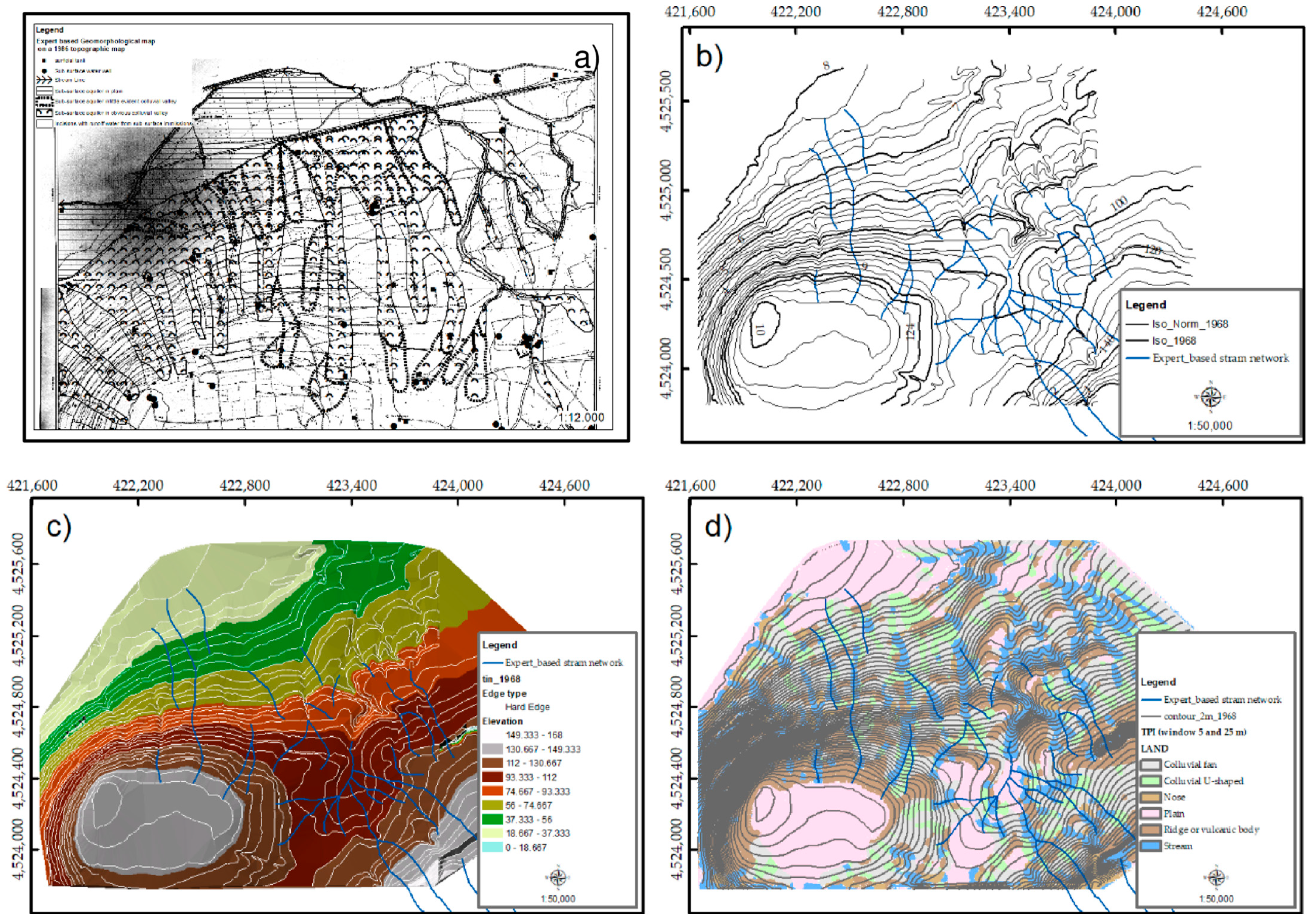
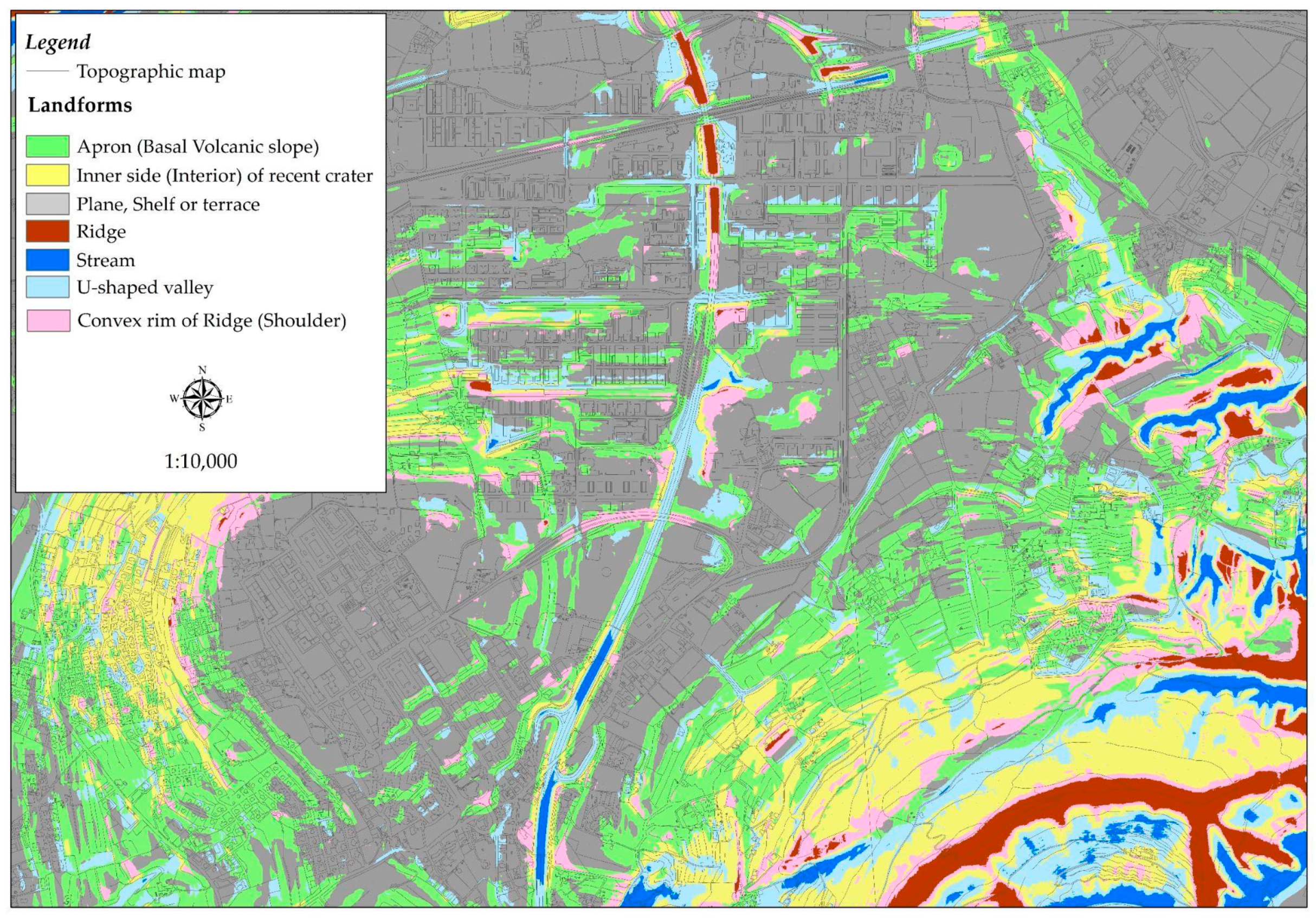
2.5. Hydro-Geomorphological Layer

The hydro-geomorphological study concerns the reconstruction in conceptual and cartographic terms of the geomorphology, hydrogeology and hydrology of the sites. This layer was necessary to reproduce a subsurface water availability map, with a view to establishing the sustainable use of the water resource, avoiding the use of water from deep aquifers. Considering that the Monteruscello area is completely urbanized, the reconstruction of a hydro-geomorphological model was possible from official historical studies [25]. The hydro-geomorphologic map (H-G map) procedure is described in [54], which maps the runoff mechanisms from the morphologic conformation and geologic setting of the sites, influencing the behaviour of the soils in terms of geotechnical and hydraulic characteristics and consequently, the hydrologic and hydrogeologic response of the area. The procedure, developed in a GIS environment, combines the geological map, reinterpreted in terms of permeability, with the geomorphological map. The resulting map, reinterpreted according to [54] in terms of runoff mechanisms from the combination of geomorphological elements and lithotypes, provides the H-G map.
In order to draw the geomorphological map, historical cartographies, both geomorphologic and topographic, were used; this is due to the fact that the natural morphology, which was the existing condition prior to the construction of the infrastructure, was completely buried, as the area, being an urbanized environment, had undergone changes over the years due to intense human activities.
Fundamental to the aforementioned analyses was, among others, the 1968 topographic map depicting the centre of Monteruscello in pre-urbanization conditions. Starting from this cartography, which was first geo-referenced according to the UTM-WGS84 33N reference system and then transformed into vector files with the ARCSCAN tool of ARCGIS 9.2, the morphology of the sites before the building transformation was reproduced. From this geo-referenced cartographic base, the geomorphological map was drawn on an expert basis, which was subsequently used for a visual validation of the geomorphological mapping derived from LIDAR and provided by the Ministry of the Environment and Agriculture. The automatic geomorphological map was produced by adopting the Topographic Position Index (TPI) procedure proposed by [55] with small and large circular cells of 5 and 25 m, respectively. The choice of cell size is derived from a visual comparison between the expert-based and the TPI-derived map, as this procedure is based on a moving window analysis that must be calibrated from time to time. The objective geomorphological map, once optimized, was reclassified in terms of the water storage capacity generated on the slope, according to the procedure of [56].
In addition, the permeability of the lithotypes present in the study area was defined from historical data and from both cartographic and sector-specific projects concerning the geological and hydrogeological characteristics of the area. In particular, the studies drawn up by Lirer and Pescatore [25], who drafted the geological report supporting the Monteruscello project, constituted the main reference. This document is one of the official pre-urbanization, geological historical documents (consisting of a 1:4000 scale geological map, a 1:4000 scale slope map, a 1:4000 scale soil depth map, geological and stratigraphic sections, and stratigraphies of 23 continuous core drilling borings (involving the Monteruscello area, being number 7), which also testifies to the more superficial geological nature of the territory.
The hydro-geomorphological reconstruction of the area was subsequently tested by means of field surveys aimed at verifying the presence of hydraulic structures in the area built during the urban planning period for the regimentation of surface water. The resulting map system has been used as a guide for the design in order to define the location, depth and type of the deep wells, sub-superficial drains and tanks, as well as the irrigation system.

3. Results

Through data collection, it was possible to address the issues present on the territory by dividing them into layers (Figure 7). Some have been addressed within the architectural urban analysis, while others have been addressed within the hydro-geomorphological analysis. The results of the analysis by layers produced two types of contributions and reflections from the two areas, which were subsequently merged together in the design solution of the new agro-urban landscape, thereby representing a shared result.

3.1. Architectural and Urban Analysis Results by Layers

The architectural–urban analysis by layers was conducted by addressing the urban directions, the design of the neighbourhood, the ancient traces and the perceptions of the landscape.

3.1.1. Urban Directions

The urban direction layers produced new interpretative drawings of the territory which have highlighted that:
  • The neighbourhood is potentially a large public park and centre for sporting activities. Today, its public park is a strip of greenery; urban policies strengthen the presence of sports facilities that can make the neighbourhood a great attraction, for sports and leisure use.
  • Within the Phlegraean Fields Park, the district has a strategic position. Although not directly affected by the zoning of the park, it is the first location one encounters in a southerly direction, towards the sea and the gulf, making it appear as an urban gateway to the city and to the entire territory.
  • The infrastructure networks that affect the district vary in size and purpose. The most important road for local mobility is an elevated highway that divides the neighbourhood into two halves. Neighbourhood roads, on the other hand, can be divided into two categories: the first includes large roads that connect the neighbourhood to neighbouring territories; the second category includes smaller roads that serve as connections within the neighbourhood. The neighbourhood is also characterized by pedestrian routes that cross it in a north–south direction and connect areas at different altitudes. The study of the routes and infrastructural connections has shown that, despite the construction since the district’s foundation of a widespread system of pedestrian routes and the presence in the area of the Circumflegrea network stop, the road network has always been more heavily used than other systems of travel.
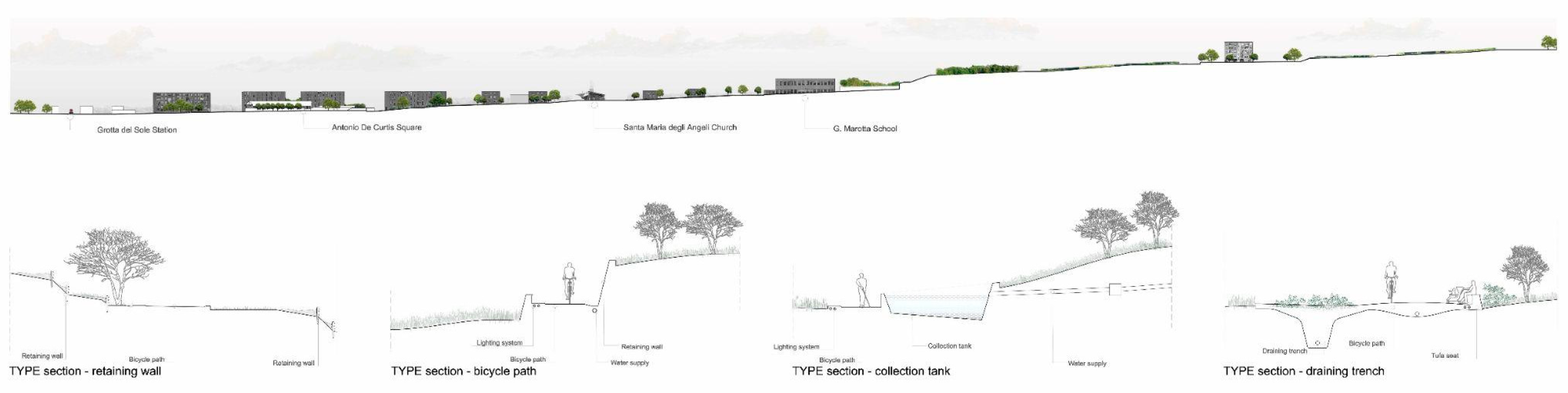
  • The neighbourhood does not currently have an alternative crossing system to the car, and the existing walking paths are not widely used. Their large size and green spaces underlie their potential for use through a soft mobility system. Today, the cycle path is only present within the neighbourhood public park. Both the local association and the administration intend to invest in a cycle and pedestrian system, which could be of great interest to the neighbourhood and for its use in terms of the landscape. This could project the area into a broader dimension, also considering that the Municipality of Pozzuoli is traversed by the Ciclovia del Sole, the national cycle path that absorbs the European route, Eurovelo 7, which crosses Central Europe from north to south [57,58].

3.1.2. The District Foundation Plan

The study of the original design was conducted through various topics such as the geometry of the neighbourhood’s design, the urban and rural plot, the design of the urban crossing systems, and morphological parts. A comparison with the current condition was then conducted to understand which parts have been realised and which have not. From the analyses it is evident that:
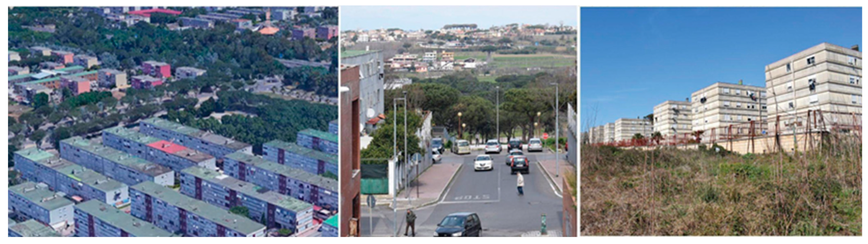
  • The neighbourhood design is based on the construction of terraces that follow the altimetry of the site. The new geography, characterized by earthworks with the filling in of new parts, has showcased the district as a succession of concrete planes on which public buildings and residential complexes are laid out.
  • The urban layout is based on the definition of three different morphological units: the centre, the commercial area and the university area. These three units correspond to the three different zones; they have the same north–south layout and present a simple, geometric urban grid, similar to that of a chessboard, which is square in some parts and rectangular in others. The urban grid is wider at the borders with the agricultural areas and the countryside, and it becomes denser as one approaches the urbanized part, towards the centre. The centre and the commercial area, although following the same north–south directions, have different measurements on the urban grid. The centre, simulating the oldest part of the district, has a denser urban grid with an almost square grid, while the commercial area is characterized by larger urban blocks closer to a rectangular shape. The differences in urban plots, as well as in the sizes of streets and urban spaces, define hierarchies. These differences are more evident in the streets, which are small and narrow for pedestrians, while vehicular streets are a larger size according to the importance of the connection. Smaller streets serve the neighbourhood on a scale closer to a human scale, while larger streets consisting of tree-lined boulevards, connect the neighbourhood to other parts of the city.
  • From a compositional point of view, the geometry of the neighbourhood is organized through vertical and horizontal axes. The horizontal axes are the three large tree-lined streets that cross the urban fabric in an east–west direction and connect the neighbourhood to other parts of the city. The vertical axes, on the other hand, are streets on a neighbourhood scale. The most important is the central and symmetrical axis with respect to the entire neighbourhood around which the station square is organized.
  • In reality, not all the project is completed, and not everything that is finished follows the design by Agostino Renna of 1983. Through a comparison of the project drawings with the reality of the built environment, one can see that many parts of the neighbourhood remain only on paper, with the built parts having been severed from the important elements. Among these, the central pedestrian axis with the station square and the archaeological park and the university citadel are unrealized parts. In the same way as some road axes have also not been completed, these totally upset the balance of the layout.
  • From an urban point of view, there is a clear gap between the humble size of the building blocks characterized by a height of around 10 m compared to the large size of the driveways. Signs of mobility represent clear marks on the urban fabric that have a great impact on urban quality. The elevated main road that traverses it vertically across its entire dimension is a great urban caesura, as is Via Nicolardi with the large driveway in its centre, which represents a separation between the southern and northern parts of the district. The pedestrian streets, which are the elements closest to the scale of the neighbourhood, are not used much, probably because they have never been completed. Some of these routes have also been interrupted or have been incorporated into the residential complexes at their side.

3.1.3. Historical Traces

Studies have been undertaken which refer to the presence of historical traces in the area. These have led to diagrammatic re-drawings showing the following themes:
  • From the study of the ancient routes and ancient representations of the Phlegraean Fields, the particular position that the area assumed in Roman times was highlighted. Although not directly affected by the presence of extra-urban routes, the area was probably characterized by agricultural land with small rural settlements.
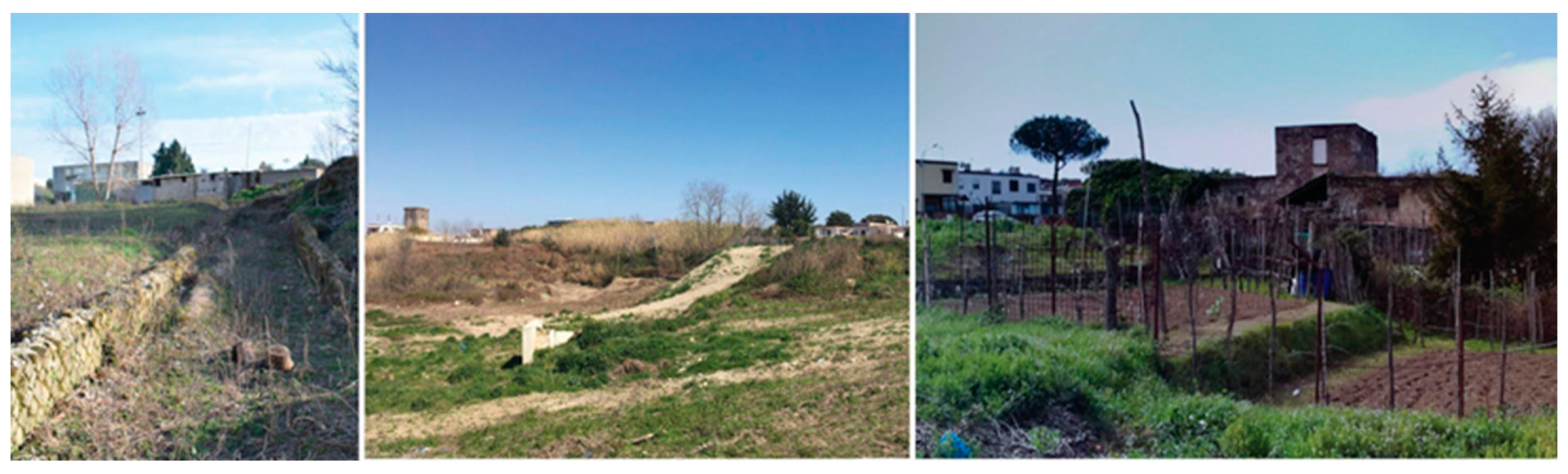
  • Most of the areas involved in the transformation are subject to archaeological restrictions which take into account the remains and the archaeological traces before the urbanization of the area. There were significant traces of the anthropization of the area even in Roman times, for example, the Villa of Hannibal, an archaeological site with the remains of a Roman residence, the ownership of which has been traced back to the Carthaginian leader. In one of the district areas are the remains of an opus reticulatum wall, a cistern and a well. These traces, in fact, indicate land use and represent tangible signs of the ancient agrarian landscape. Among these, a number of ancient farms reveal that the entire territory was characterized by large cultivated expanses dotted with the widespread presence of farms for rural use.
  • From the comparison with the territorial maps prior to the urbanization of the district in the 1980s, it was understood that although the area was already anthropized, and some of its reliefs had already been terraced, the construction of the new district in 1983 significantly altered the landscape.
  • Land use maps (PRG Plan of 1982) recording the agricultural landscape before urbanization show the presence of arable fields, vineyards, orchards, olive groves and vegetable cultivations without specifying the species. The areas are now abandoned or uncultivated; some of them present spontaneous tree and herbaceous essences.

3.1.4. Walking and Perception

Through the perception layer, the pedestrian and visual paths traversing the area were analysed. A territory was discovered, made of heterogeneous areas, some characterized by the significant presence of fill land, others with woods of trees and bushes, and others already cultivated, albeit illegally through field surveys. Within the neighbourhood, long paths, characterized by stairs and flat sections, flank the built-up area and are like visual paths connecting separate parts of the territory. There are interesting visual points towards the sea and the Licola coastline, such as the vertical wall of a former tuff quarry in the Torre San Severino area in Giugliano (NA) extending southwards towards Cuma.
The Santa Chiara tower is part of the system of visual and defensive towers that characterize the coast and some of the inland areas. It is therefore a visual point that refers to a system on a territorial scale. At the same time, it is an important element within the district as it is visible from several sides and allows orientation within the urban grid.

3.2. Hydro-Geomorphological Results

By studying historical data based on previous geological and geomorphological studies and site-specific historical maps, it was possible to reconstruct the geology, now buried, of the centre of Monteruscello. More specifically, historical investigations carried out during the construction phase of the Monteruscello settlement, conducted by Prof. Lirer and Prof. Pescatore [25], reveal the presence of ‘clean white pumices’ with high transmissivity and a homogeneous distribution throughout the area. This is evidence of draining the horizons of subsurface aquifers in palaeochannels filled with colluvial deposits, supported by ochre-brown paleosoilsand consisting of argillified ash with lower permeability. Given these characteristics, the thickness can vary between 2 and 5 m.
Traces and evidence consistent with the results derived from historical geologic analyses are obtained from field-surveys and from the analysis of historical topographic maps realised in 1965 and 1968, in which old farms with annexed wells and superficial tanks are shown, highlighting the historical hydro-geomorphological characteristics of the area. In fact, deep wells testify the presence of deep aquifers, while on the other hand, superficial wells and tanks testify the presence of suspended aquifers within the layers of clean pumice, used even in the past eras to irrigate cultivated fields.
As far as direct surface runoff is concerned, this was channelled into a system of drainage networks which have now undergone a hydro-geomorphological disconnection. In fact, the district, which is traversed by the state road, has undergone a clear hydro-geomorphological disconnection highlighted by the presence of the remnants of incised channels that are now truncated. In the past, these channels, which are evidence of the generation of surface runoff and solid transport phenomena, created an hydrogeologic risk for the inhabitants downstream of them.
At present, these valleys constitute truncated streams the original paths of which have been reconstructed through expert-based geomorphological analysis of the 1968 topographic map. In addition, the results of the maps derived from the historical topographic map using both the expert-based method and the automatic TPI procedure, indicate where the now-buried morphological concavities and essential geomorphic features have been delimited (Figure 8).
Specifically, the geomorphological map drawn up by an expert geomorphologist highlights the presence of buried channels formed by highly transmissive pumices in which subsurface aquifers are generated. The map, on the other hand, obtained using an automated procedure shows the presence of the volcanic building and the colluvial fan, in addition to highlighting the buried stream valleys and colluvial U-shaped form. The waters, flowing in a north-westerly direction, reach the main channel and are directed towards Licola. From the inspections carried out, the presence of part of these valleys has been verified due to the existence of reed beds, which, in turn, attest to the existence of sub-surface outflows. The passage of the valleys below the State Road 7 quarter has been found, as in the adjacent pedestrian area, there is a metal grille from which the presence of water can be seen. The geomorphological map was subsequently drawn up from LIDAR using the TPI and validated by visual comparison with the expert-based map. Similarly to the on-site surveys, it fails to highlight the presence of erosion furrows as it refers to the post-urbanization period (Figure 9).
Therefore, in order to take into account the gullies not highlighted by LIDAR, two geomorphological maps, i.e., a historical map and the map from LIDAR, were used to obtain the H-G map. Each landform, thus delimited, was associated with a runoff mechanism, according to Cuomo’s (2012) procedure, i.e., concave landforms, with the capacity to store considerable subsurface runoff, which are associated with highly permeable pumice lithologies, as well as subsurface runoff. Ridge forms or convex edges when associated with lithologies with high permeability support the generation of deep discharge, but when associated with lithologies with low permeability, they facilitate the generation of surface runoff (Figure 10).
The hydrogeomorphic map was used to design the water collection system for agricultural use (Figure 11). The project starts from the principle of preserving deep resources by using surface and sub-surface water. For this reason, our planning strategy employs small overland tanks in which, according to ancient agricultural practice, rainfall water is collected to be reused in agriculture. In addition, sub-surface drains, reaching a depth of 3 m from ground level, have been connected to these tanks to retrieve the sub-surface water. The other fundamental aspect connected to the recovery and storage of sub-surface water is the protection of the territory against hydrogeological risk. Indeed, scientific studies highlight the fundamental role of sub-surface runoff in triggering landslide phenomena.
In order to collect this water and convey it to the points of agricultural use, the following have been provided:
-
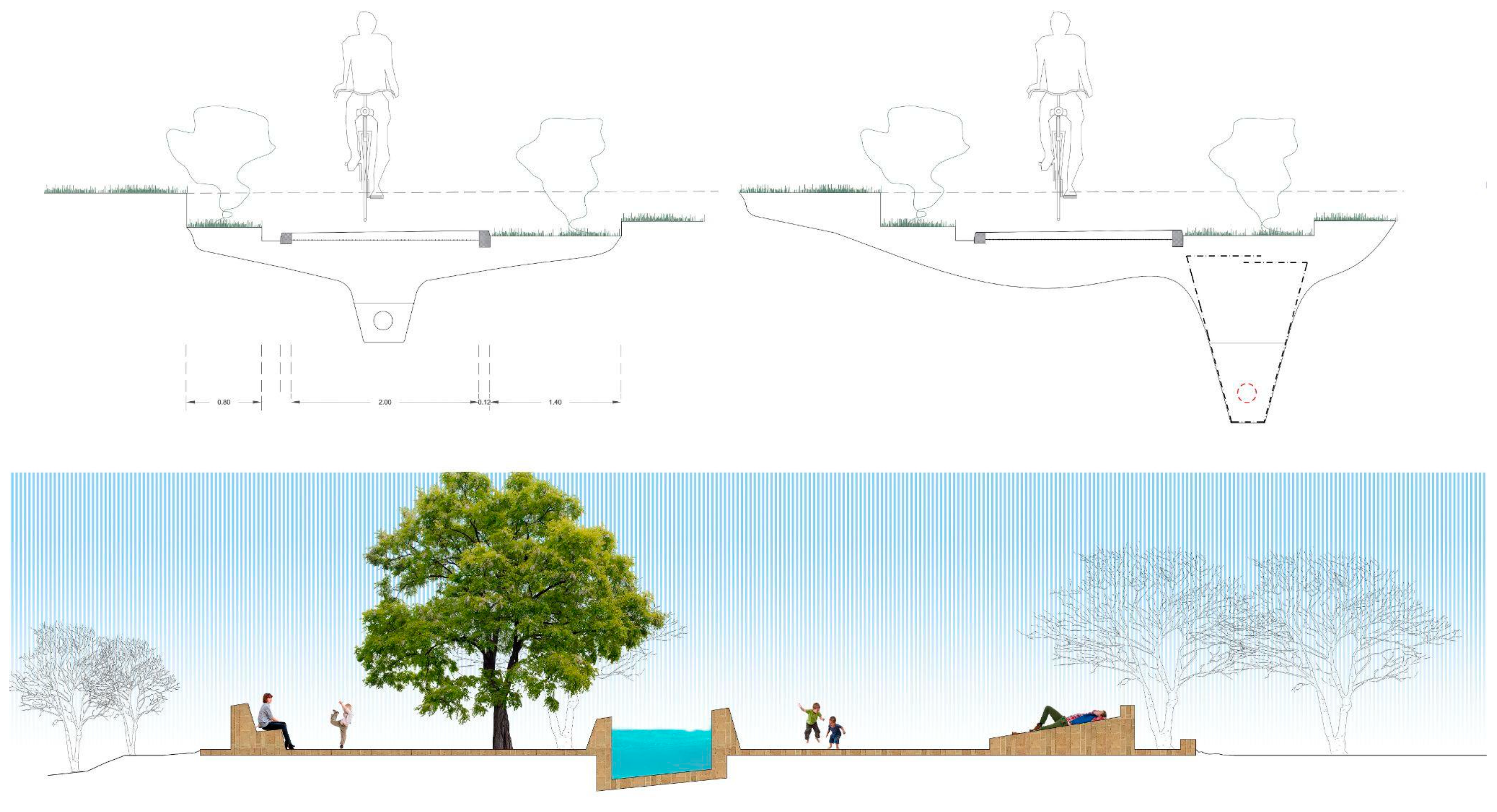
Drainage herringbone trenches to be placed within the sub-surface basins;
-
Small tanks typical of rural landscapes, to store the water collected through trenches. These tanks will be within the areas to be used for farming and placed in such a way as to enhance the distribution of water by gravity;
-
PVC pipelines to connect the aforementioned surface tank systems.
The following figure shows the water scheme deduced downstream from the hydro-geomorphological analyses conducted.

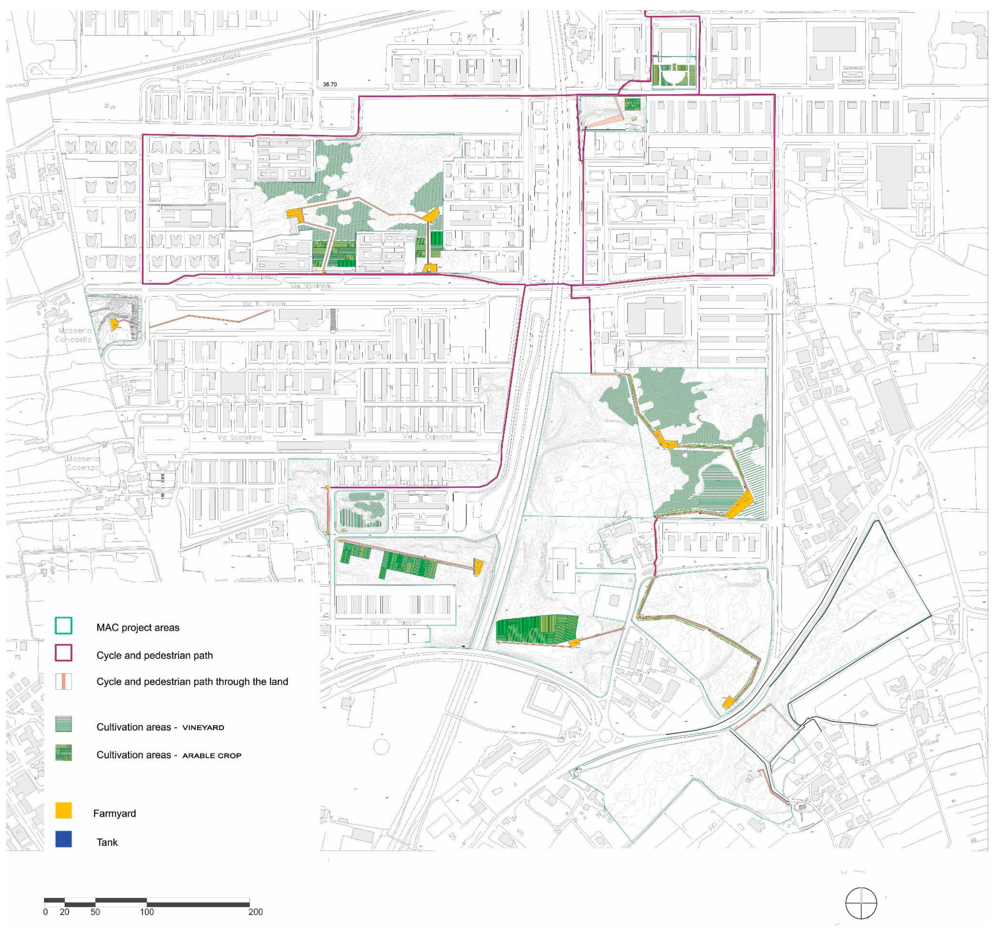
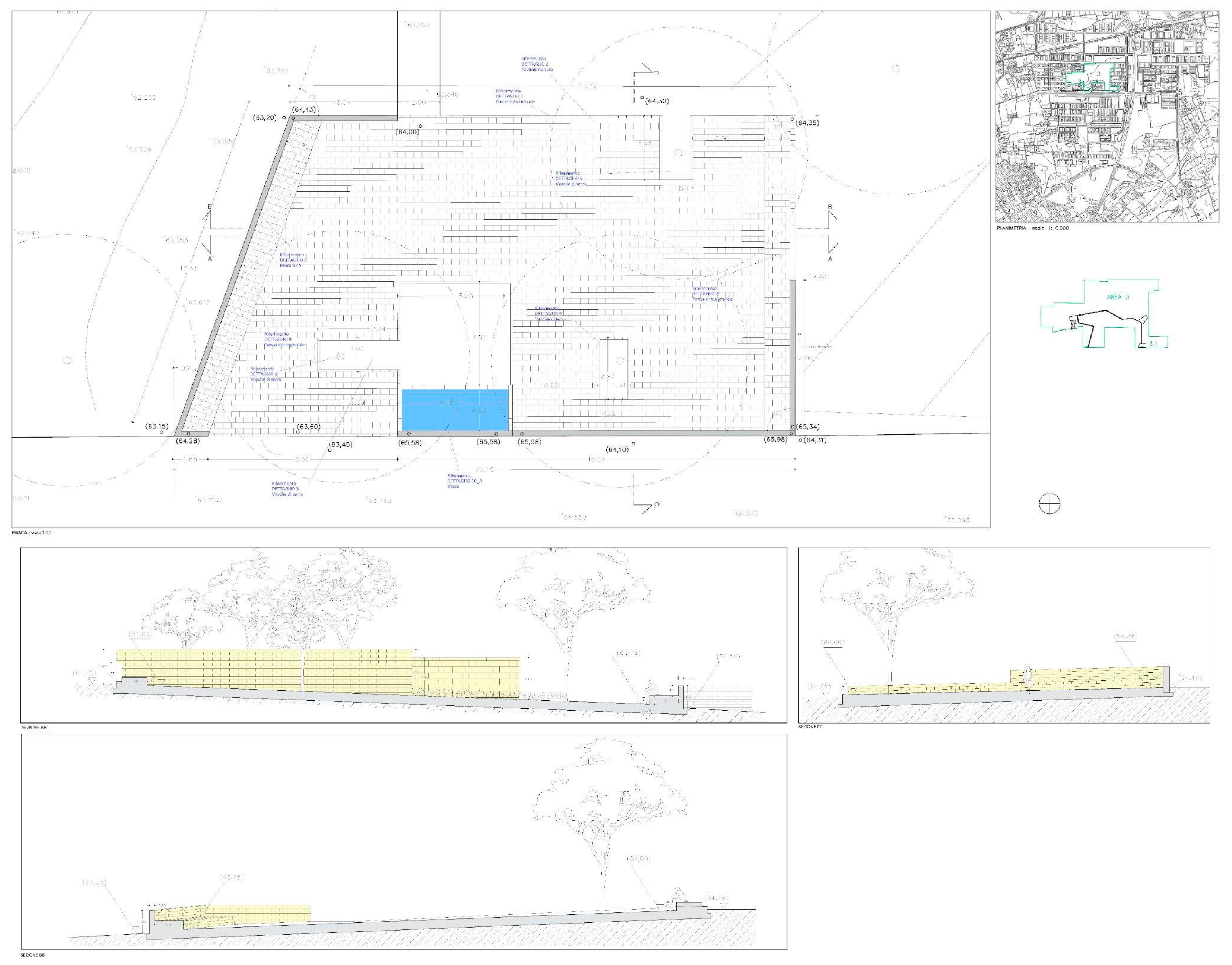
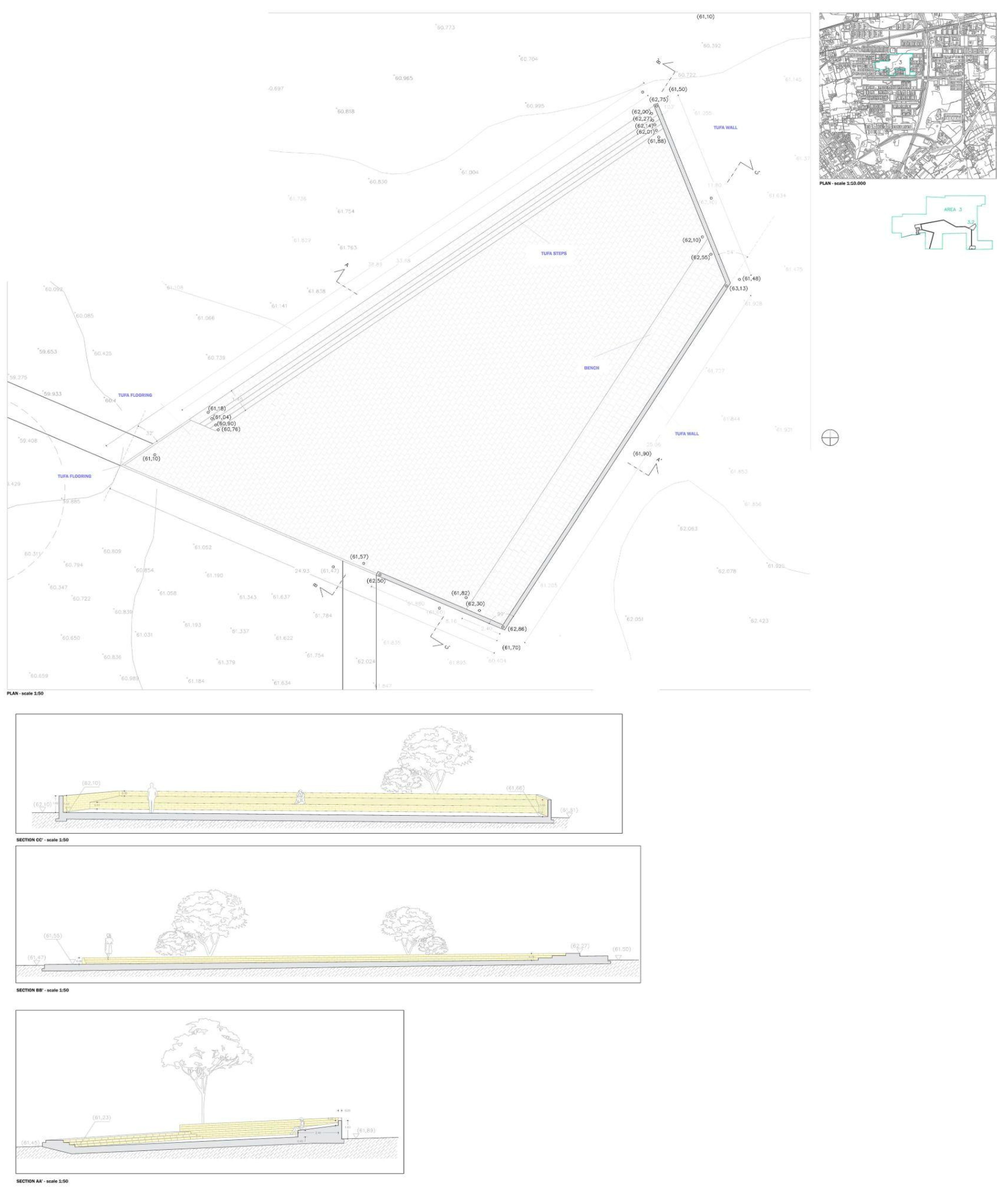
3.3. The New Agro-Urban Landscape

The layers of the two types of analysis are then intersected to define the design of the abandoned green areas in the neighbourhood. The project has chosen to transform these areas into urban farming crossed by paths and public spaces. The design of the paths and the position of the meeting areas come from experimental and geometric work with which the traces from the different layers are combined, making choices and sometimes withdrawals. As an example an ancient Roman road became a cycle path in one of the areas, while the old farm present within one of the central areas was used as a focal point for a gathering space overlooking the cultivation. The selective and interpretative work, carried out using a multi-layer approach, is aimed at integrating the various components (urban, agricultural and hydro-geomorphological) in order to reconnect the areas and the neighbourhood signs.
The work did not concern a simple intersection of the layers results, but these were evaluated with a selective criterion with the aim of coordinating the technical needs of water supply, urban and landscape needs, as well as agricultural needs.
The new cycle and pedestrian paths are anchored to the water basins, the position of which is the result of the hydrogeological layer. Furthermore, the direction of the paths is aligned with the direction of the water lines, where possible. As a project choice, the water system, involving the extraction, distribution and irrigation of water, becomes a network on which to anchor the public spaces and the paths traversing the cultivated areas. This choice derives from cultural reflections on the character of the site, strongly connected to its agricultural past, and to the intention of connecting agriculture to the urban spaces within the new interpretation of the territory. In addition, the coincidence of the footpaths being created next to the water lines reduces the construction work: both infrastructures are obtained with the same excavation. Therefore, the water system, which could be seen as a network of veins and arteries, becomes a functional backbone on which the pedestrian and cycle paths are also interconnected (Figure 11 and Figure 12).
The design of the water line, which is a necessary technical line for the collection and distribution system for agricultural purposes, is compared to the directions and layouts of the archaeological elements of the ancient landscape. The project also involves the ancient farms and the existing rural architecture within the route as elements of the public space, organizing and gathering spaces around them. Through a geometric work of axes and directions, creating connections and linking remarkable points, the project designs paths, resting spaces and belvederes that resemble public areas located within the landscape. Some of these elements, which follow the different layouts linked to existing traces, are located at particular points of the territory from which views of the landscape open up; the views allow an understanding of the geographical condition. The rest areas are designed with benches and plazas and can be used variously throughout the year and at different times of the day. A lighting system ensures use even in the evening hours for cultural events or agriculture dissemination activities. The separation of the paths and the agricultural areas, realized in various ways along the route by means of vegetation, parapets and kerbs, will also foster respect for the agricultural activities (Figure 13 and Figure 14).
In terms of cultivation, the design project included suggestions provided by partners involved in agricultural issues (the association Coldiretti). A cultivation plan was formulated based on permaculture principles, with the inclusion of traditional crops. The included crops cover the following productive categories: viticulture encompassing Falanghina and Piedirosso wine production and cultivation of the local species of fruit and vegetables such as mandarin, chickling vetch, cannellini tomatoes, peas, fava beans, broccoli, artichoke, long eggplant, potatoes, bell peppers and long squash.
In conclusion, the water system, together with the paths and areas for resting and observing the landscape, become a single element that crosses the cultivated areas, like a network, creating a new urban system that combines productive and public spaces. The possibility of overwriting new systems of circulation on the territory, defining at the same time the agricultural plan for the green areas, offers the possibility of reconnecting, through small interventions, the urban parts of the district which are today disconnected. Moreover, building new systems of relationships, namely, travel and visual relationships, is an opportunity for the neighbourhood to relocate itself within the city and the territorial complexity.

4. Discussion

The project is first and foremost a proposal to bring agricultural spaces into the city. What does it mean to bring agriculture into the city? The proposal entails the integration of urban and agricultural components. Rather than recreating a historical landscape as described in the seminal text by Emilio Sereni [59], which would be anachronistic here and above all impossible to recover, due to the invasive urban transformation, it was decided to work along the lines of contemporary studies and experimentations, such as those by Pierre Donadieu in France [2], in which new relationships between agricultural spaces, cities and territories are realized, producing new urban landscape forms [60,61,62].
The study of the intersections between the two agricultural and urban souls was the great challenge for the construction of the new landscape and also added value to the reconquest of a productive and urban space within the neighbourhood. Bringing the countryside into the urban fabric means creating dialogue between these spaces and the neighbourhood. It is necessary to ensure not only that today’s abandoned green areas are transformed by giving them a productive function, but also that this function includes and builds a dialogue with the community. Consequently, the decision was made to create cycle and pedestrian crossing paths and rest areas for various activities (Figure 15 and Figure 16).
It is clear, however, that the presence of public crossings reduces the possibilities of agriculture in these areas, as the land becomes parcelled out, making it less easy to cultivate and therefore decreasing productivity. The crossing of these areas by pedestrians is, however, necessary for urban reasons, enabling the crossing of the neighbourhood on a human scale, often denied by wide vehicular roads, and allowing the community to use the spaces by creating green spaces. Furthermore, productive agriculture in areas of the city without urban relationships would produce private and enclosed areas, which while aesthetically attractive from the top of the buildings, would not be entirely different from industrial areas or specialized production areas and would constitute barriers and places of interruption and disconnection within the urban fabric. The presence of the crossings is, therefore, essential to achieve the true integration of agriculture and the city (Figure 17 and Figure 18).

5. Conclusions

The solution studied with the creation of crossing paths could also find application in other contexts, provided that the size of the intervention allows it. In the case of the Monteruscello district, it was in fact the large extension of the areas that facilitated the partial reduction in agricultural productivity in favour of a great urban advantage: the obtaining of public green areas, new pedestrian connections and public spaces.
The work applied the methodology of layers, which allowed a reasoned integration of the different components. Unlike other works within the discipline of architecture that had used architectural layers in the process, such as those of Peter Eisenman [36], here, the layers also involved other disciplines, technical issues and data. In fact, the work was developed by recovering traditional agricultural uses and respecting ancient routes while applying information and data. In particular, the study of subsurface water was possible through the careful interpolation of data. It was therefore an approach that used contemporary methods and tools and at the same time recovered traditions and historical traces, with an interpolation that offered new possibilities and the implementation of innovative methodologies. Moreover, the layer methodology, when compared to other works such as those related to multi-criteria analysis [63], was based on a work of selection and interpretation that led to choices and hierarchies among the layers. The layer methodology could be applied systematically in different situations and places, but the solutions would depend on the specificities of the area; data analysis, choice of layers, priorities and selection criteria will vary on a case-by-case basis.
If the integration of agricultural and urban components in a multidisciplinary study represented the project approach, and the use of layers with interpolation between data and traditional issues represented the methodology used, experimentation on the concrete case subsequently found sustainable solutions in relation to various aspects.
From an environmental point of view, the method proposed here aims to reduce the uncontrolled use of water from deep wells. In specific research regarding agricultural methods, it is widely shared that the concept of water-efficient irrigation is one of the essential options that can reduce global water scarcity [64,65]. Along these lines, subsurface water components, which originate from the rainy input of infiltration process into the soil, are used as irrigation water in spite of the presence of deep water. Indeed, we have applied the hydro-geomorphological approach, allowing the objective delimitation of the source areas, where each runoff component is generated.
Therefore, for the supply of water necessary for agriculture, works were avoided that would have irreversibly impacted the land, such as deep wells that would, moreover, produce continuous operating expenses. The proposed alternative of canals and tanks with subsurface water facilitates the continuous use of waters that would be lost. The project solution is therefore sustainable as it reduced construction work, did not impact the land, reduced excavation, eliminated management costs and, above all, used existing and recovered water resources.
Furthermore, and perhaps most important of all, water control has been achieved in the area, reducing the risks of future floods and inundation. This is an added value that did not represent one of the initial project objectives, is proof of the correctness of the process used and indicates the sustainable effects of the project. In the specific case of the study area, since it is located at the foot of the Monte Sant’Angelo Hill, the slopes of which are characterized by hydrogeological constraint, due to the presence of canals that channel water towards the Monteruscello settlement, the need to regulate this water in order to prevent possible erosion is evident. This problem is primarily linked to subsurface waters which are present in the area due to its geological and hydrogeological nature and tends to flow down the slopes where its piezometric surface meets the ground level, causing erosion furrows. Therefore, the project intends, in addition to using water in a sustainable manner, to act as a strategic intervention for the defence of the territory from hydrogeological risk. Indeed, scientific studies highlight the fundamental role of sub-surface runoff in triggering landslide phenomena [66,67,68].
Further research should start from this conclusion in order to analyse more deeply the traces of the agricultural past in the current land and determine how these can form the basis of a stronger relationship between landscape design, agricultural issues and the water system.

Author Contributions

Conceptualization, A.C. (Alessandra Como), A.C. (Albina Cuomo) and L.S.P.; Methodology, A.C. (Alessandra Como), A.C. (Albina Cuomo) and L.S.P.; Writing—original draft, A.C. (Alessandra Como), A.C. (Albina Cuomo) and L.S.P.; Writing—review & editing, A.C. (Alessandra Como), A.C. (Albina Cuomo) and L.S.P.; Visualization, A.C. (Albina Cuomo) and L.S.P.; Supervision, A.C. (Alessandra Como). All authors have read and agreed to the published version of the manuscript.

Funding

This research was founded by the MAC project, an Urban Innovative Action Iniziative. Research group within the University of Salerno: Paolo Alfano, Alessandra Como, Albina Cuomo, Domenico Guida, Luisa Smeragliuolo Perrotta, Lucia Terralavoro, Carlo Vece.

Institutional Review Board Statement

Not applicable.

Informed Consent Statement

Not applicable.

Data Availability Statement

Data sharing is not applicable to this article.

Conflicts of Interest

The authors declare no conflict of interest.

References

  1. Desvigne, M. Paesaggi di Prefigurazione; Lotus Booklet: Milan, Italy, 2022. [Google Scholar]
  2. Donadieu, P. Campagne Urbane; Donzelli Editore: Roma, Italy, 2006. [Google Scholar]
  3. Agnoletto, M.; Guerzoni, M. La Campagna Necessaria. Un’Agenda d’Intervento Dopo l’Esplosione Urbana; Quodlibet: Macerata, Italy, 2012. [Google Scholar]
  4. Fleury, A.; Donadieu, P. De l’agriculture périurbaine à l’agriculture urbaine. Courr. L’environnement L’inra 1997, 31, 45–61. [Google Scholar]
  5. Nougarèdes, B. Quelles solutions spatiales pour intégrer l’agriculture dans la ville durable? Le cas des «hameaux agricoles» dans l’Hérault. Norois 2011, 221, 53–66. [Google Scholar] [CrossRef] [Green Version]
  6. Thareau, B. L’agriculture dans une dynamique urbaine: Négociations autour d’usages du territoire. Géogr. Écon. Soc. 2006, 8, 351–368. [Google Scholar] [CrossRef]
  7. Van Veenhuizen, R. Cities Farming for the Future; RUAF Foundation, IIRR, ETC Urban Agriculture: Silang, Philippines, 2006. [Google Scholar]
  8. Mayté, B.; Elodie, V. L’éco-urbanisme face aux espaces non bâtis: L’enjeu de la mixité. Urbia Les Cah. Du Dév. Urbain Durable 2007, 4, 167–192. [Google Scholar]
  9. Downey, D.J.; Smith, D.A. Metropolitan Reconfiguration and Contemporary Zones of Transition: Conceptualizing Border Communities in Postsuburban California. J. Urban Aff. 2011, 33, 21–44. [Google Scholar] [CrossRef]
  10. Cognetti, F.; Gambino, D.; Faccini, J.L. Periferie del Cambiamento. Traiettorie di Rigenerazione tra Marginalità e Innovazione a Milano; Quodlibet: Macerata, Italy, 2020. [Google Scholar]
  11. Forgaci, C. Smart and resilient cities: How can big data inform spatial design and planning for urban resilience? In Contesti. Città, Territori, Progetti; Firenze University Press: Firenze, Italy, 2020; pp. 62–71. [Google Scholar]
  12. Mayer-Schönberger, V.; Cukier, K. Big Data: A Revolution That Will Transform How We Live, Work and Think; John Murray: London, UK, 2013. [Google Scholar]
  13. Zasada, I. Multifunctional peri-urban agriculture-A review of societal demands and the provision of goods and services by farming. Land Use Policy 2011, 28, 639–648. [Google Scholar] [CrossRef]
  14. Mougeot, L.J.A. Growing Better Cities: Urban Agriculture for Sustainable Development; IDRC (International Development Research Centre): Ottawa, ON, Canada, 2006. [Google Scholar]
  15. Como, A.; Smeragliuolo Perrotta, L.; Vece, C. Agro-Urban Landscape: The case study of Monteruscello-Naples. In 24th ISUF International Conference-Valencia 2017: “City and territory in the Globalization Age”; Editorial Universitat Politècnica de València: València, Spain, 2018; pp. 1701–1709. [Google Scholar]
  16. Alfano, P.; Como, A.; Cuomo, A.; Guida, D.; Smeragliuolo Perrotta, L.; Terralavoro, L.; Vece, C. Monterusciello Agro-City Landscape project: Strategies for a new relationship between the built and the environment. In Small Towns … from Problem to Resource. Sustainable Strategies for the Valorization of Building, Landscape and Cultural Heritage in Inland Areas; Fiore, P., D’Andria, E., Eds.; Franco Angeli: Milan, Italy, 2019; pp. 535–545. [Google Scholar]
  17. Alfano, P.; Como, A.; Cuomo, A.; Guida, D.; Smeragliuolo Perrotta, L.; Terralavoro, L.; Vece, C. Multiscale, Objective Hydro-geomorphological Mapping and Modelling Application: The Case Study of Monteruscello Agro City Project (MAC). Urban. Inf. 2018, 278, 317–321. [Google Scholar]
  18. Alfano, P.; Como, A.; Cuomo, A.; Guida, D.; Smeragliuolo Perrotta, L.; Terralavoro, L.; Vece, C. Il progetto del paesaggio Agro-Urbano come interpretazione delle tracce storico identitarie del territorio: Il caso studio di Monteruscello. In La città Globale. La Condizione Urbana Come Fenomeno Pervasivo; Pretelli, M., Tamburini, R., Tolic, I., Eds.; AISU International: Torino, Italy, 2020; pp. 560–570. [Google Scholar]
  19. Siola, U. Progetto Pozzuoli: Rapporto di Sintesi sul Lavoro Svolto al 30 Giugno 1985. Quaderni di Documentazione Progetto Pozzuoli; La Buona Stampa: Ercolano, Italy, 1985. [Google Scholar]
  20. Barberi, F.; Luongo, G. Monografie Finali—Phlegrean Fields, Carta Geologica e Gravimetrica dei Campi Flegrei; Centro Nazionale delle Ricerche (CNR), Progetto Finalizzato Geodinamica, Sottoprogetto 3: Sorveglianza dei Vulcani Attivi e Rischio Vulcanico Scala 1:15,000; Salomone: Rome, Italy, 1986. [Google Scholar]
  21. Ciarcia, S.; Vitale, S. Carta Geologica Della Campania: Nota Illustrativa; Consiglio Nazionale dei Geologi, AGICOM: Rome, Italy, 2018. [Google Scholar]
  22. Allocca, V.; Celico, F.; Celico, P.; De Vita, P.; Fabbrocino, S.; Mattia, C.; Monacelli, G.; Musilli, I.; Piscopo, V.; Scalise, A.R.; et al. Note Illustrative Della Carta Idrogeologica dell’Italia Meridionale -Explanatory Notes of the Hydrogeological Map of Southern Italy; Istituto Poligrafico e Zecca dello Stato: Roma, Italy, 2007. [Google Scholar]
  23. Di Gennaro, A.; Terribile, F. I Suoli Della Provincia di Napoli-Carta 1:75000 e Legenda; Camera di Commercio Industria Artigianato e Agricoltura GE.PRO.TER: Napoli, Italy, 1999. [Google Scholar]
  24. Romano, M. Agostino Renna. Monteruscello (Pozzuoli). Domus 1986, 674, 25–33. [Google Scholar]
  25. Lirer, L.; Pescatore, T.S. La geologia Della Aree di Monteruscello e del Centro Storico di Pozzuoli. Quaderni di Documentazione Progetto Pozzuoli; Fratelli Giannini: Napoli, Italy, 1987. [Google Scholar]
  26. Colpo, M.; D’Agostino, G.; Previtali, G.; Signorelli, A. La Valorizzazione Della Memoria Collettiva nei Campi Flegrei. Quaderni di Documentazione Progetto Pozzuoli; La Buona Stampa: Ercolano, Italy, 1989. [Google Scholar]
  27. Augé, M. Nonluoghi. Introduzione a un’antropologia Della Surmodernità; Elèuthera: Milan, Italy, 2009. [Google Scholar]
  28. Koolhaas, R. Junkspace. Per un Ripensamento Radicale Dello Spazio Urbano; Quodlibet: Macerata, Italy, 2006. [Google Scholar]
  29. Chaslin, F. Architettura Della Tabula Rasa. Due Conversazioni con Rem Koolhaas; Electa: Milan, Italy, 2003. [Google Scholar]
  30. Koolhaas, R.; Man, B. S, M, L, XL [Small, Medium, Large and Extra Large]; Taschen: Colon, Germany, 1998. [Google Scholar]
  31. Antonini, E.; Gaspari, J.; Boulanger, S.O.M. Multi-layered urban strategies to foster the smart cities development. In The Sustainable City X; Brebbia, C.A., Florez-Escobar, W.F., Eds.; WIT Press: Southampton, UK, 2015; Volume 194, pp. 23–34. [Google Scholar]
  32. Ponte, V. The Multilevel City. In The City as a System; Proceedings, Boston Architectural Center Workshop Series on Environmental Design for Decision-Makers in Government; Boston Architectural Center: Boston, MA, USA, 1968; pp. 19–65. [Google Scholar]
  33. Yoos, J.; James, V. The Multilevel Metropolis. Places J. 2016. Available online: https://placesjournal.org/article/multilevel-metropolis-urban-skyways/?cn-reloaded=1 (accessed on 14 April 2023). [CrossRef] [PubMed]
  34. Giusta, F.C. Peter Eisenman. Alchimie Figurative; Aión: Firenze, Italy, 2014. [Google Scholar]
  35. Tschumi, B. Architettura e Disgiunzione; Pendragon: Bologna, Italy, 2005. [Google Scholar]
  36. Derrida, J. ; Eisenman. P. Chōra L Works; Kipnis, J., Leeser, T., Eds.; Monacelli Press: New York, NY, USA, 1997. [Google Scholar]
  37. Capozzi, R. Agostino Renna: La Forma Della Città; Clean Edizioni: Napoli, Italy, 2016. [Google Scholar]
  38. Escalona, F.; Francese, D. Monteruscello: L’impianto Urbano e gli Edifici Pubblici; Fratelli Giannini: Napoli, Italy, 1987. [Google Scholar]
  39. Pagano, L. Agostino Renna: Rimontaggio di un Pensiero Sulla Conoscenza Dell’architettura: Antologia di Scritti e Progetti 1964–1988; Clean Edizioni: Napoli, Italy, 2012. [Google Scholar]
  40. Capuano, A. Paesaggi di Rovine. Paesaggi Rovinati; Quodlibet: Macerata, Italy, 2014. [Google Scholar]
  41. Miano, P.; Izzo, F.; Pagano, L. I Campi Flegrei. L’architettura per i Paesaggi Archeologici; Quodlibet: Macerata, Italy, 2017. [Google Scholar]
  42. Como, A.; Smeragliuolo Perrotta, L. Il diagramma: Il disegno del pensiero. In Proceedings V Congreso Internacional de Expresión Gráfica en Ingeniería, Arquitectura y Carreras Afines y XI Congreso Nacional de Profesores de Expresión Gráfica en Ingeniería, Arquitectura y Carreras Afines; EGraFIA: Rosario, Argentina, 2014; pp. 388–394. [Google Scholar]
  43. Cerami, G. La riqualificazione Ambientale dei Campi Flegrei: Gli Elementi Strutturali per un Piano Paesistico. Quaderni di Documentazione Progetto Pozzuoli; Fratelli Giannini: Napoli, Italy, 1988. [Google Scholar]
  44. D’Antonio, M.; Giannola, A.; Sicca, L. Elementi per la Definizione di un Piano di Sviluppo Socio-Economico di Pozzuoli e Dell’area Flegrea. Quaderni di Documentazione Progetto Pozzuoli; La Buona Stampa: Ercolano, Italy, 1989. [Google Scholar]
  45. Pisciotti, L.; Miano, P. I Campi Flegrei: Luoghi, Formazione e Trasformazione Della Città. Quaderni di Documentazione Progetto Pozzuoli; Fratelli Giannini: Napoli, Italy, 1988. [Google Scholar]
  46. Vitale, A. Il Controllo Ambientale nei Campi Flegrei. Quaderni di Documentazione Progetto Pozzuoli; La Buona Stampa: Ercolano, Italy, 1989. [Google Scholar]
  47. Gerundo, R. Pozzuoli, notes about recent urban history and development prospects. In The case of Phlegraean Fields Coastal Area on the Mediterranean Sea; Acierno, A., Camilletti, P., Eds.; Editura Universitară Ion Mincu: Bucarest, Romania, 2020; pp. 20–23. [Google Scholar]
  48. Gerundo, R.; Di Maggio, F. Monteruscello: Periferia di Stato? Planum J. 2007. Available online: www.planum.net%2Fdownload%2Fdi-maggio_gerundo-pdf&usg=AOvVaw1dOaU61UXnDkCOW6HdD9K- (accessed on 14 April 2023).
  49. Cuomo, A.; Guida, D. Hydro-Geomorphologic-Based Water Budget at Event Time-Scale in A Mediterranean Headwater Catchment (Southern Italy). Hydrology 2021, 8, 20. [Google Scholar] [CrossRef]
  50. Gerundo, R.; Gerundo, C. Re-shaping a post-seismic re-construction district through cycling infrastructures. The case of Monterusciello. In Town and Infrastructure Planning for Safety and Urban Quality; Pezzagno, M., Tira, M., Eds.; CRC Press: Boca Raton, FL, USA, 2018; pp. 177–182. [Google Scholar]
  51. Careri, F. Walkscapes. Camminare Come Pratica Estetica; Einaudi: Torino, Italy, 2002. [Google Scholar]
  52. Tan, Z.; Xue, C.Q.L. Walking as a Planned Activity: Elevated Pedestrian Network and Urban Design Regulation in Hong Kong. In Journal of Urban Design; Routledge: London, UK, 2014; pp. 723–727. [Google Scholar]
  53. Maiuri, A. I Campi Flegrei; Istituto Poligrafico dello Stato: Roma, Italy, 1981. [Google Scholar]
  54. Cuomo, A. The Contribute of the HydroGeomorphology in the Evaluation of the Flood Discharge in the Campania Region. Ph.D. Thesis, University of Salerno, Fisciano, Italy, 2012. [Google Scholar]
  55. Weiss, A.D. Topographic position and landforms analysis. In Proceedings of the Poster presented at the Esri User Conference, San Diego, CA, USA, 2001; Available online: http://www.jennessent.com/downloads/tpi-postertnc_18x22.pdf (accessed on 30 March 2023).
  56. Troch, P.A.; Paniconi, C.; Emiel van Loon, E. Hillslope-storage Boussinesq model for subsurface flow and variable source areas along complex hillslopes: 1. Formulation and characteristic response. Water Resour. Res. 2003, 39, 1316. [Google Scholar] [CrossRef]
  57. Pedroni, C. Ciclopista del Sole. Dal Brennero al Lago di Garda e Verona; Ediciclo: Portogruaro, Italy, 2006; Volume 1. [Google Scholar]
  58. Pedroni, C. Ciclopista del Sole-Tratto 2. Dal Lago di Garda a Firenze in Bicicletta; Ediciclo: Portogruaro, Italy, 2009. [Google Scholar]
  59. Sereni, E. Storia del Paesaggio Agrario Italiano; Laterza: Bari, Italy, 1961. [Google Scholar]
  60. Cucchi, M.; Gambino, D.; Longo, A. La Città Degli Orti. Coltivare e Costruire Socialità nei Piccoli Spazi Verdi Della Grande Milano; Quodlibet: Macerata, Italy, 2020. [Google Scholar]
  61. Caramaschi, S. Beyond Landscape (and) Urbanism. Una riflessione sull’atteggiamento paesaggistico nella trasformazione della città contemporanea. In Atti della XXI Conferenza Nazionale SIU. Confini, Movimenti, Luoghi. Politiche e Progetti per Città e Territori in Transizione; Planum Publisher: Rome, Italy, 2019. [Google Scholar]
  62. Ideas for Regeneration; Lotus International 174; Editoriale Lotus: Milan, Italy, 2022.
  63. Fattinnanzi, E.; Mondini, G. L’analisi Multicriteri Tra Valutazione e Decisione; DEI: Rome, Italy, 2015. [Google Scholar]
  64. Levidow, L.; Zaccaria, D.; Maia, R.; Vivas, E.; Todorovic, M.; Scardigno, A. Improving water-efficient irrigation: Prospects and difficulties of innovative practices. Agric. Water Manag. 2014, 146, 84–94. [Google Scholar] [CrossRef] [Green Version]
  65. Grimaldi, M.; Sebillo, M.; Vitiello, G.; Pellecchia, V. Planning and Managing the Integrated Water System: A Spatial Decision Support System to Analyze the Infrastructure Performances. Sustainability 2020, 12, 6432. [Google Scholar] [CrossRef]
  66. Li, W.C.; Dai, F.C.; Wei, Y.Q.; Wang, M.L.; Min, H.; Lee, L.M. Implication of subsurface flow on rainfall-induced landslide: A case study. Landslides 2016, 13, 1109–1123. [Google Scholar] [CrossRef]
  67. Leroueil, S. Natural slopes and cuts: Movement and failure mechanisms. Geotechnique 2001, 51, 197–243. [Google Scholar] [CrossRef]
  68. Li, W.C.; Lee, L.M.; Cai, H.; Li, H.J.; Dai, F.C.; Wang, M.L. Combined roles of saturated permeability and rainfall characteristics on surficial failure of homogeneous soil slope. Eng. Geol. 2013, 153, 105–113. [Google Scholar] [CrossRef]
Figure 1. Map of Italy with the province of Naples (left); map of the province of Naples with the municipality of Pozzuoli (right). Authors’ elaboration.
Sustainability 15 09208 g001
Figure 2. Geologic map (1:25,000) (from [25]) Legend: AV: pyroclastic deposits made up of a basal sequence of layers containing angular pumice fragments with rare lava lithic and yellow tuff clast, with interbedded ash layers; CC (Holocene pyroclastic deposits series): succession of pyroclastic deposits interbedded into paleosoils. The pyroclastic layers are mainly made up of angular pumice and scoria fragment horizons with interbedded sand to ash layers thinly bedded waved; MRU (Monteruscello yellow tufa formation): a slightly welded to unwelded waved sequence of thin ash beds, passing to a yellow welded deposit made up of fine ash matrix engulfing pumice fragments; GA (Gauro yellow tufa formation): welded yellow pyroclastic deposit, made up of pale grey altered pumice fragments and rare obsidian clasts embedded in a sand-ashy matrix.
Sustainability 15 09208 g002
Figure 3. On the left: Monteruscello district location within the Phlegraean Fields based on the Campania Region Technical Map (2004–2005); on the right: the green areas in the neighbourhood included in the transformation project based on the map of the Pozzuoli Urban Authority. Authors’ elaboration.
Sustainability 15 09208 g003
Figure 4. Neighbourhood photographs (retrieved in 2018 from Google maps website and by the authors from field surveys—2019).
Sustainability 15 09208 g004
Figure 5. Archaeological traces in the area of a Roman road (by the authors from field surveys—2019).
Sustainability 15 09208 g005
Figure 6. Methodological chart. Authors’ elaboration.
Sustainability 15 09208 g006
Figure 7. Urban and architectural layers chart. Authors’ elaboration.
Sustainability 15 09208 g007
Figure 8. Preliminary, expert-based geomorphologic map from the 1968 topographic map (a); contour lines map and drainage line derived from the 1968 topographic map (b); triangular irregular network of Monteruscello in 1968 (GIS-based reconstruction) (c); automatic morphologic map using TPI procedure (d). Authors’ elaboration.
Sustainability 15 09208 g008
Figure 9. Geomorphologic map based on LIDAR data and derived from a TPI procedure. Authors’ elaboration.
Sustainability 15 09208 g009
Figure 10. Hydro-geomorphological map of the Monteruscello district. Authors’ elaboration.
Sustainability 15 09208 g010
Figure 11. Hydraulic system for collecting and conveying subsurface water. Authors’ elaboration.
Sustainability 15 09208 g011
Figure 12. Agro-urban landscape design map. Authors’ elaboration.
Sustainability 15 09208 g012
Figure 13. Agro-urban landscape design section Farmyard Santa Chiara 15.4 and 15.3. Authors’ elaboration.
Sustainability 15 09208 g013
Figure 14. Agro-urban landscape design section Farmyard 3.3 (Edoardo Scarpetta road) and Farmyard Belvedere 8.1 (Umberto Saba road). Authors’ elaboration.
Sustainability 15 09208 g014
Figure 15. Agro-urban landscape design section. Authors’ elaboration.
Sustainability 15 09208 g015
Figure 16. Agro-urban landscape design section. Authors’ elaboration.
Sustainability 15 09208 g016
Figure 17. Farmyard n°3.1 (Edoardo Scarpetta road)—plan and sections. Authors’ elaboration.
Sustainability 15 09208 g017
Figure 18. Farmyard n°3.2 (Edoardo Scarpetta road)—plan and sections. Authors’ elaboration.
Sustainability 15 09208 g018
Disclaimer/Publisher’s Note: The statements, opinions and data contained in all publications are solely those of the individual author(s) and contributor(s) and not of MDPI and/or the editor(s). MDPI and/or the editor(s) disclaim responsibility for any injury to people or property resulting from any ideas, methods, instructions or products referred to in the content.

