
On the Use of Radar and Optical Satellite Imagery for the Monitoring of Flood Hazards on Heritage Sites in Southern Sinai, Egypt

 ,
,  and
and 
Abstract
1. Introduction
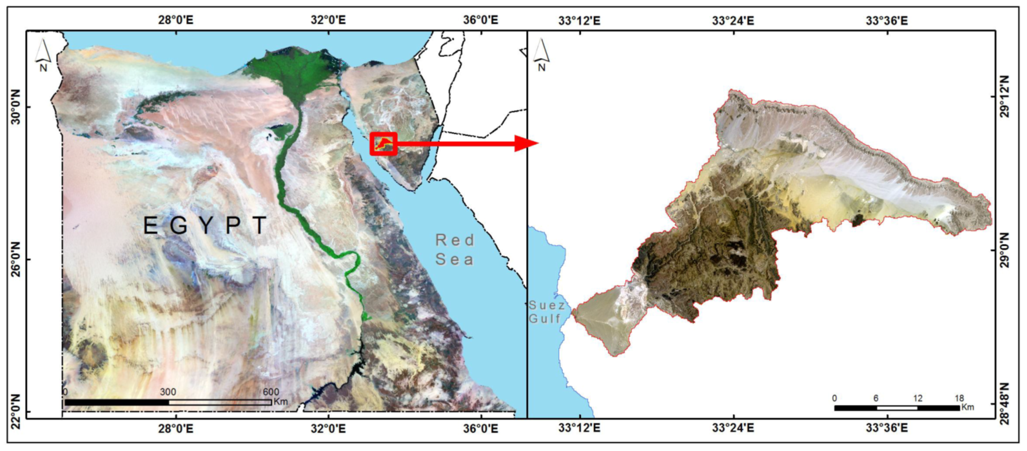
1.1. The Study Area
1.2. Problem Definition
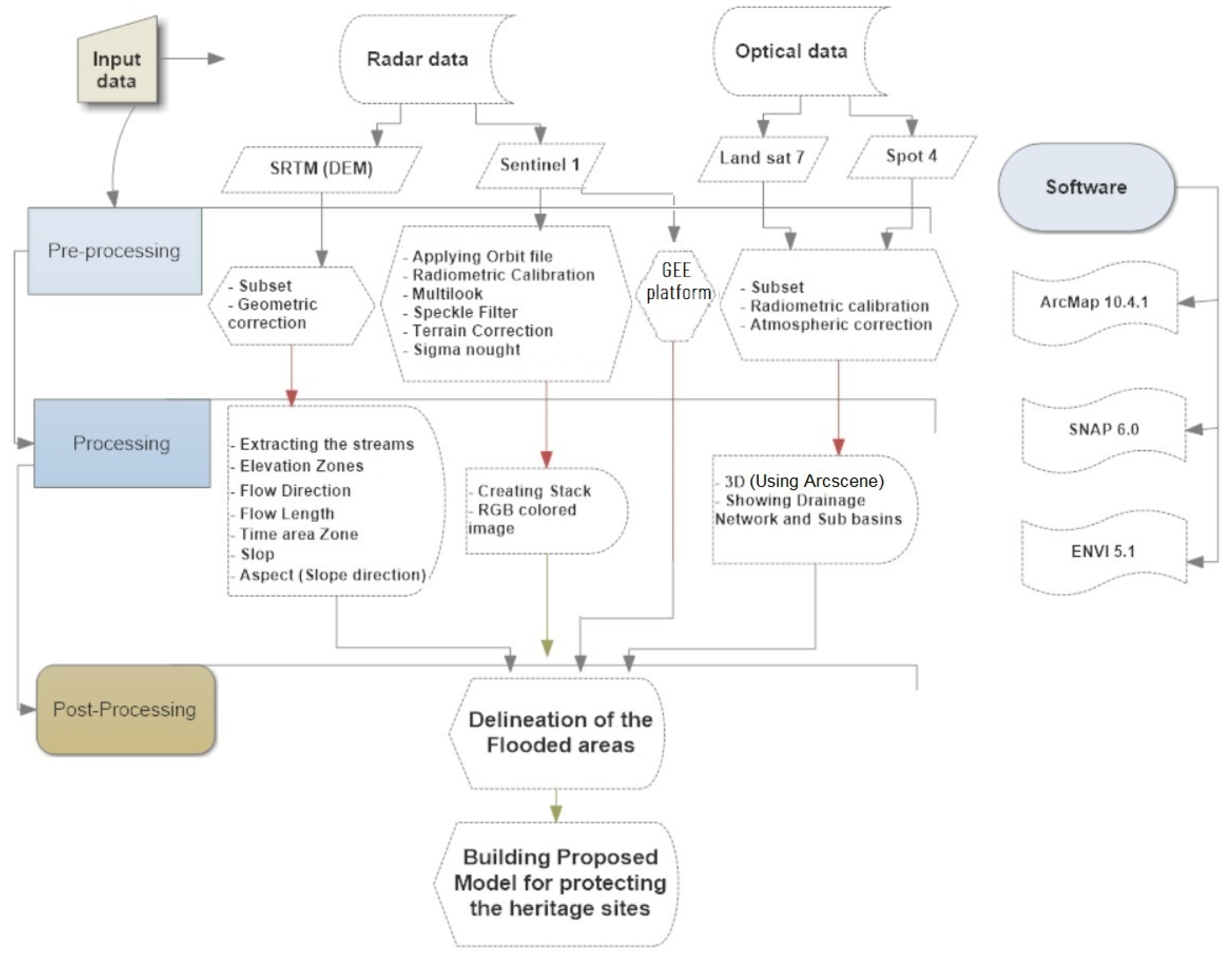
2. Materials and Methods
2.1. Data Collection
2.2. Methods
2.2.1. Optical Data Processing
2.2.2. Radar Data Analysed Using SNAP Software
G:〖20〗^* log10(|VHpost|)
B:〖20〗^* log10(0.5^* |VVpre|+|VHpre|)).
2.2.3. Radar Data Analysed Using the GEE Platform
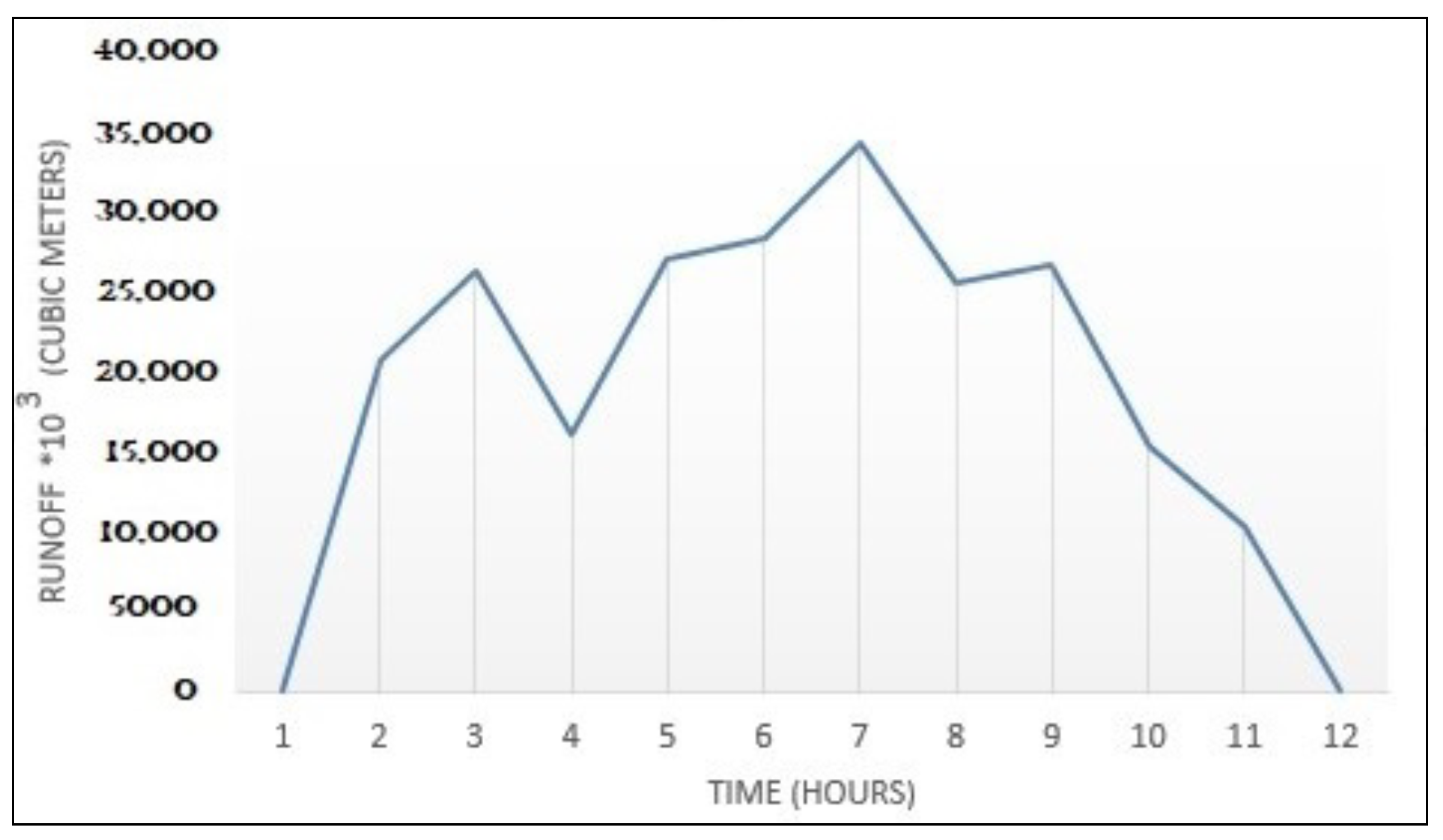
2.2.4. Estimating the Runoff Volume and Peak Flow Rate
R = 1.05 − 0.0053 A,
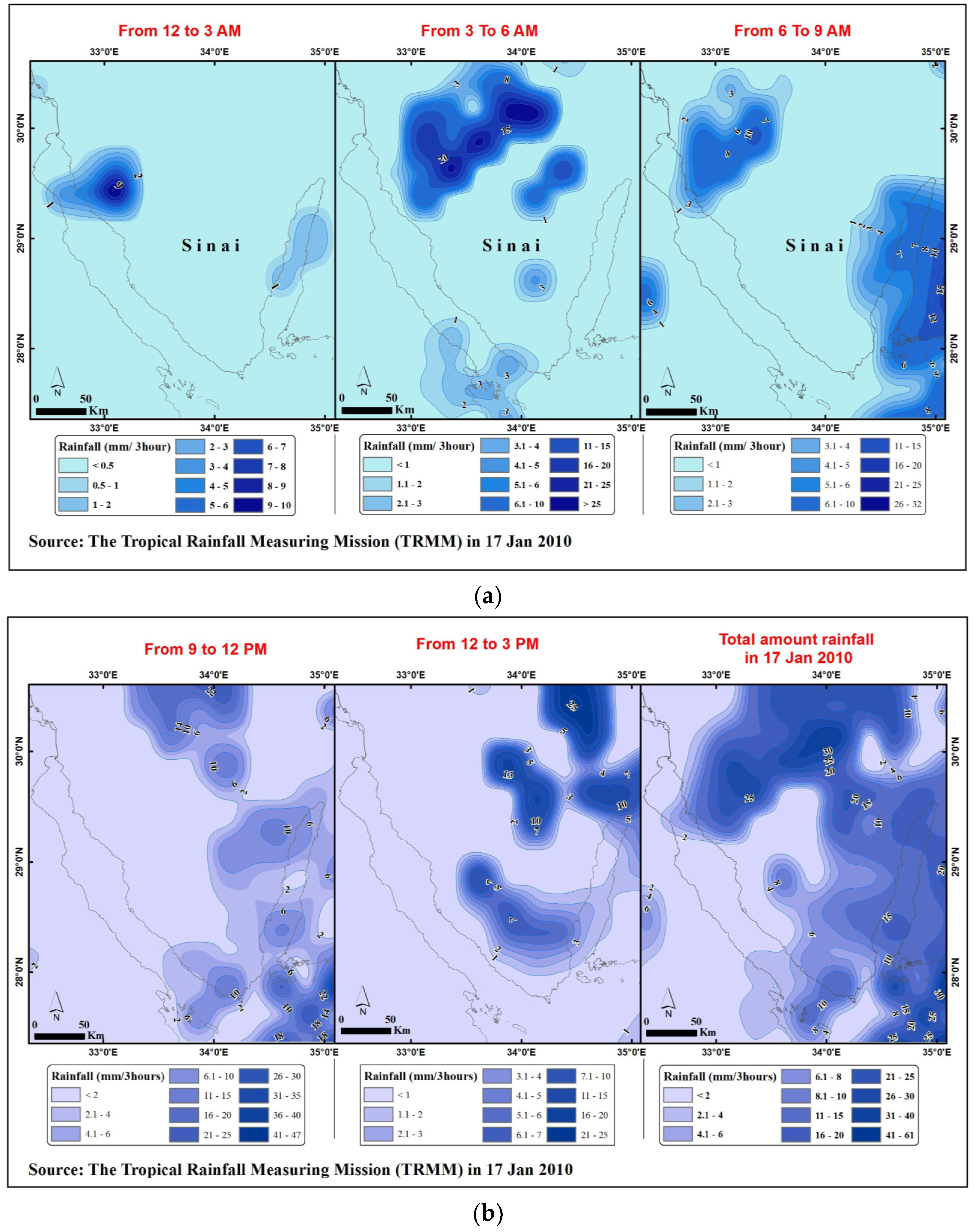
3. Results and Discussion
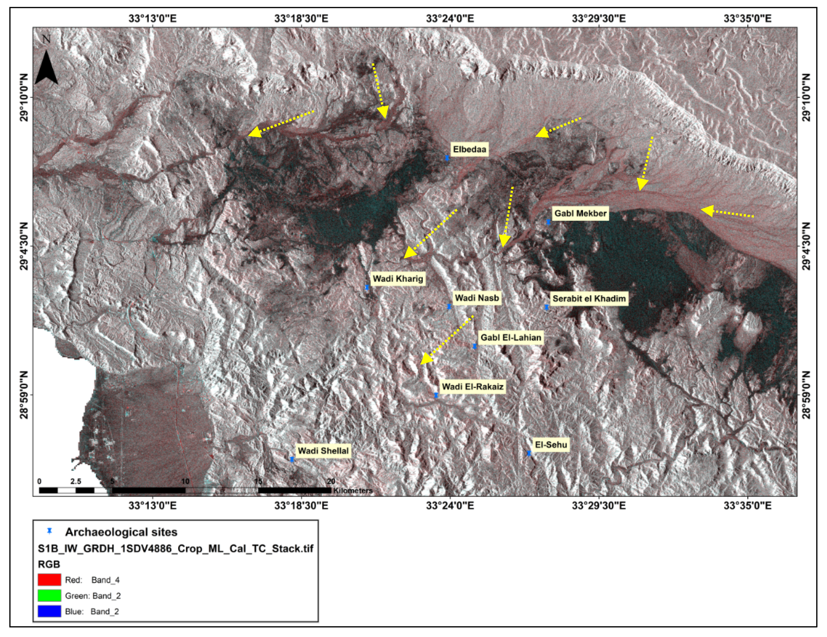
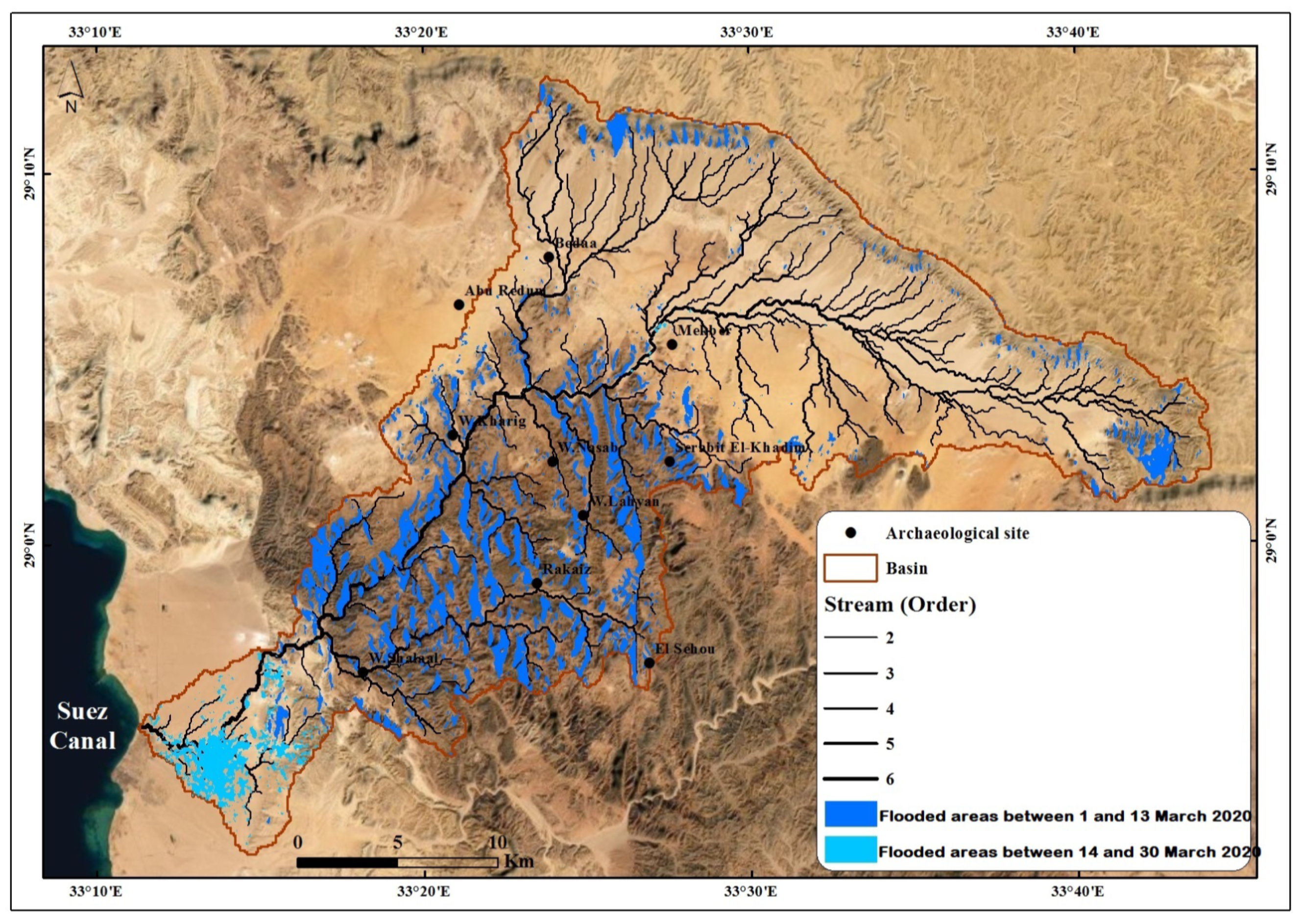
3.1. Satellite Image Results
3.2. Extracting Morphometric and Hydrologic Parameters
4. Recommendations
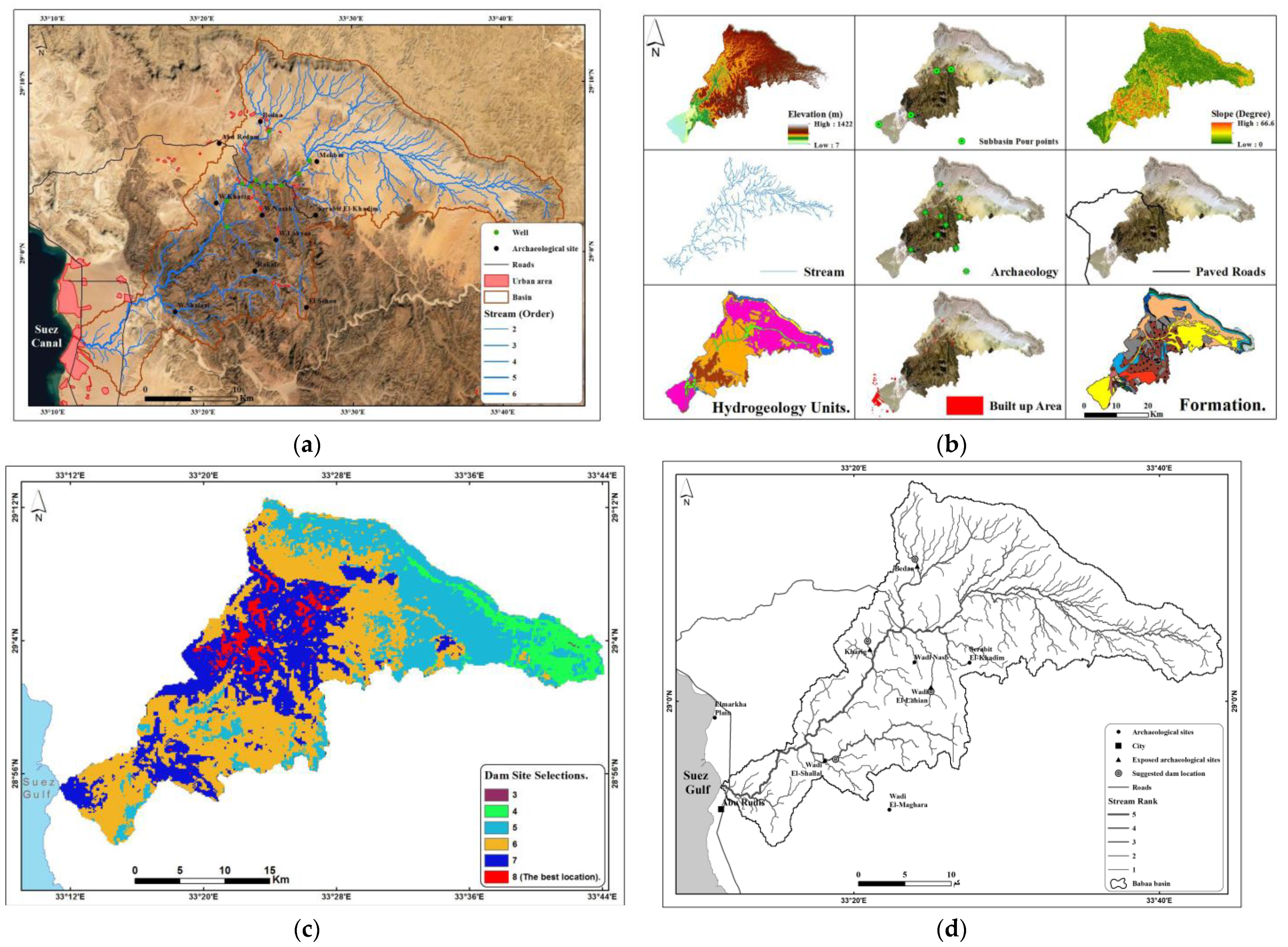
- The drainage network, elevation, slope, urban, archaeological sites, roads, sub-basin pour points, lithological units, and hydrogeological units were used as input.
- The lithological and hydrogeological units, having a field with numbers from one to nine equivalent to each unit, were converted to a raster image.
- The urban, archaeological sites, roads, sub-basin pour points, and stream layers were subjected to Euclidean distances for deriving the distance between the layer and surrounding grids.
- We prepared a suitability map by creating datasets that were reclassified into nine classes according to the dam construction’s suitability to be ready for being combined where higher values are more suitable.
- Weighting and combining datasets: the reclassified datasets are ready to be combined and weighted according to importance (distance to streams = 19%, slope = 14%, distance to roads = 13%, hydrogeological units = 13%, lithological units = 13%, dem = 7%, distance to archaeological sites = 7%, distance to built-up area = 7%, distance to sub-basin pour points: 7%), where a parameter with a higher percentage has more influence as an input in the suitability model (Figure 10b–d).
5. Conclusions
Author Contributions
Funding
Institutional Review Board Statement
Informed Consent Statement
Data Availability Statement
Acknowledgments
Conflicts of Interest
References
- Köhler, E.C.; Hart, E.; Klaunzer, M. Wadi el-Sheikh; A new archaeological investigation of ancient Egyptian chert mines. PLoS ONE 2017, 2, e0170840. [Google Scholar] [CrossRef]
- Al-Qudah, K.A. Floods as water resource and as a hazard in arid regions; a case study in Southern Jordan. Jordan J. Civ. Eng. 2011, 5, 148–161. [Google Scholar]
- Llasat, M.C.; Llasat-Botija, M.; Prat, M.A.; Porcu, F.; Price, C.; Mugnai, A.; Lagouvardos, K.; Kotroni, V.; Katsanos, D.; Michaelides, S.; et al. High-impact floods and flash floods in Mediterranean countries: The FLASH preliminary database. Adv. Geosci. 2010, 23, 47–55. [Google Scholar] [CrossRef]
- Moawad, M.B.; Abdel Aziz, A.O.; Mamtimin, B. Flash floods in the Sahara; a case study for the 28 January 2013 flood in Qena, Egypt. Geomat. Nat. Hazards Risk 2016, 7, 215–236. [Google Scholar] [CrossRef]
- Harding, J. Reducing the Flash Flood Hazard in the Sinai. Available online: http://resolver.tudelft.nl/uuid:cdc31bc2-39ac-4f95-b900-3a76a157718c (accessed on 25 December 2017).
- Baldi, M.; Amin, D.; Zayed, I.S.A.; Dalu, G.A. Extreme rainfall events in the Sinai Peninsula. In Proceedings of the EGU General Assembly Conference Abstracts, Vienna, Austria, 23–28 April 2017; Volume 19, p. 13971. [Google Scholar]
- Faisal, A.; Khan, H.A.H. Application Of Gis And Remote Sensing In Disaster Management; A Critical Review Of Flood Management. In Proceedings of the International Conference On Disaster Risk Mitigation, Dhaka, Bangladesh, 23–24 September 2018. [Google Scholar]
- Kundzewicz, Z.W. Non-structural flood protection and sustainability. Water Int. 2002, 27, 3–13. [Google Scholar] [CrossRef]
- Tapete, D. Remote sensing and geosciences for archaeology. Geosciences 2018, 8, 41. [Google Scholar] [CrossRef]
- Garcia, A.; Orengo, H.; Conesa, F.; Green, A.; Petrie, C. Remote sensing and historical morphodynamics of alluvial plains. The 1909 indus flood and the city of Dera Ghazi Khan (province of Punjab, Pakistan). Geosciences 2019, 9, 21. [Google Scholar] [CrossRef]
- Thompson, R.; Humphrey, J.; Harmer, R.; Ferris, R. Restoration of Native Woodland on Ancient Woodland Sites; Forestry Commission: Edinburgh, UK, 2003. [Google Scholar]
- Thakur, P.K.; Laha, C.; Aggarwal, S.P. River bank erosion hazard study of river Ganga, upstream of Farakka barrage using remote sensing and GIS. Nat. Hazards 2012, 61, 967–987. [Google Scholar] [CrossRef]
- Tzioutzios, C.; Kastridis, A. Multi-Criteria Evaluation (MCE) method for the management of woodland plantations in floodplain areas. ISPRS Int. J. Geo-Inf. 2020, 9, 725. [Google Scholar] [CrossRef]
- Elfadaly, A.; AR Abouarab, M.; M El Shabrawy, R.R.; Mostafa, W.; Wilson, P.; Morhange, C.; Silverstein, J.; Lasaponara, R. Discovering potential settlement areas around archaeological tells using the integration between historic topographic maps, optical, and radar data in the northern Nile Delta, Egypt. Remote Sens. 2019, 11, 3039. [Google Scholar] [CrossRef]
- Rättich, M.; Martinis, S.; Wieland, M. Automatic flood duration estimation based on multi-sensor satellite data. Remote Sens. 2020, 12, 643. [Google Scholar] [CrossRef]
- World Health Organization. Flooding. Managing Health Risks in the WHO European Region. Available online: https://www.euro.who.int/__data/assets/pdf_file/0003/341616/Flooding-v11_ENG-web.pdf (accessed on 15 January 2017).
- Elfadaly, A.; Attia, W.; Lasaponara, R. Monitoring the environmental risks around Medinet Habu and Ramesseum Temple at West Luxor, Egypt, using remote sensing and GIS techniques. J. Archaeol. Method Theory 2018, 25, 587–610. [Google Scholar] [CrossRef]
- Elfadaly, A.; Attia, W.; Qelichi, M.M.; Murgante, B.; Lasaponara, R. Management of cultural heritage sites using remote sensing indices and spatial analysis techniques. Surv. Geophys. 2018, 39, 1347–1377. [Google Scholar] [CrossRef]
- Elfadaly, A.; Wafa, O.; Abouarab, M.; Guida, A.; Spanu, P.; Lasaponara, R. Geo-environmental estimation of land use changes and its effects on Egyptian Temples at Luxor City. ISPRS Int. J. Geo-Inf. 2017, 6, 378. [Google Scholar] [CrossRef]
- Omar, A.E.; Arnous, M.O.; El-Ghawaby, M.A.; Alshami, A.S.; El Zalaky, M.A. Flash Flood Hazard Mapping of Wadi Baba Basin, Southwestern Sinai, Egypt. Sinai J. Appl. Sci. 2016, 5, 409–426. [Google Scholar] [CrossRef][Green Version]
- Elfadaly, A.; Abutaleb, K.; Naguib, D.M.; Lasaponara, R. Detecting the environmental risk on the archaeological sites using satellite imagery in Basilicata Region, Italy. Egypt. J. Remote Sens. Space Sci. 2022, 25, 181–193. [Google Scholar] [CrossRef]
- El Afandi, G.; Morsy, M.; El Hussieny, F. Heavy rainfall simulation over sinai peninsula using the weather research and forecasting model. Int. J. Atmos. Sci. 2013, 2013, 241050. [Google Scholar] [CrossRef]
- Omran, A.; Schroder, D.; El Rayes, A.; Geriesh, M. Flood hazard assessment in Wadi Dahab, Egypt based on basin morphometry using GIS techniques. GI_Forum Program Comm. 2011. [Google Scholar] [CrossRef]
- Elmoustafa, A.M.; Mohamed, M.M. Flash flood risk assessment using morphological parameters in Sinai Peninsula. Open J. Mod. Hydrol. 2013, 3, 8. [Google Scholar] [CrossRef]
- Elfadaly, A.; Abate, N.; Masini, N.; Lasaponara, R. SAR Sentinel 1 Imaging and Detection of Palaeo-Landscape Features in the Mediterranean Area. Remote Sens. 2020, 12, 2611. [Google Scholar] [CrossRef]
- Elfadaly, A.; Lasaponara, R. Cultural heritage management using remote sensing data and GIS techniques around the archaeological area of ancient Jeddah in Jeddah City, Saudi Arabia. Sustainability 2020, 12, 240. [Google Scholar] [CrossRef]
- Abate, N.; Elfadaly, A.; Masini, N.; Lasaponara, R. Multitemporal 2016–2018 Sentinel-2 Data Enhancement for Landscape Archaeology; The Case Study of the Foggia Province, Southern Italy. Remote Sens. 2020, 12, 1309. [Google Scholar] [CrossRef]
- Jo, M.J.; Osmanoglu, B.; Zhang, B.; Wdowinski, S. Flood extent mapping using dual-polarimetric Sentinel-1 synthetic aperture radar imagery. Int. Arch. Photogramm. Remote Sens. Spat. Inf. Sci. 2018, 42, 711–713. [Google Scholar]
- Westphal, J.A. Hydrology for drainage system design and analysis. Stormwater. Collect. Syst. Des. Handb. 2001. Available online: https://books.google.com.eg/books?id=Bki4_m-N_rAC (accessed on 15 November 2021).
- Boyd, M.J.; Bufill, M.C. Determining runoff routing model parameters without rainfall data. J. Hydrol. 1989, 108, 281–294. [Google Scholar] [CrossRef]
- EL-Rayes, A.E.; Geriesh, M.H.; Omran, A.F. Flood Control and Water Management in Arid Environment Case Study on Wadi Hagul, Gulf of Suez Region, Egypt. In Proceedings of the The International Conference of Water Conservation in Arid Regions. King AbdulAziz Univ., Jeddah, Saudi Arabia, 12–14 October 2009. [Google Scholar]
- Bell, F.C. Estimating Design Floods from Extreme Rainfall. PhD. Thesis, Colorado State University, Fort Collins, CO, USA, 1968; p. 29. [Google Scholar]
- Helwa, M.A.; Birch, B. The demography and housing conditions of Palestinian refugees in and around the camps in Amman, Jordan. J. Refug. Stud. 1995, 6, 403–413. [Google Scholar]
- Kim, N.W.; Shin, M.J.; Lee, J.E. Application of flood-intensity-duration curve, rainfall-intensity-duration curve and time of concentration to analyze the pattern of storms and their corresponding floods for the natural flood events. In Proceedings of the EGU General Assembly Conference Abstracts, Vienna Austria, 17–22 April 2016; p. EPSC2016-11118. [Google Scholar]
- Lugo, V.M.V. Hydraulic Design of An Overland Flow Distribution System Using Lateral Weirs. PhD. Thesis, University of Puerto Rico Mayaguez Campus, Mayagüez, Puerto Rico, 2014. [Google Scholar]
- Gilewski, P.; Nawalany, M. Inter-comparison of rain-gauge, radar, and satellite (IMERG GPM) precipitation estimates performance for rainfall-runoff modeling in a mountainous catchment in Poland. Water 2018, 10, 1665. [Google Scholar] [CrossRef]
- Sapountzis, M.; Kastridis, A.; Kazamias, A.P.; Karagiannidis, A.; Nikopoulos, P.; Lagouvardos, K. Utilization and uncertainties of satellite precipitation data in flash flood hydrological analysis in ungauged watersheds. Glob. Nest J. 2021, 23, 388–399. [Google Scholar]
- Marchi, L.; Borga, M.; Preciso, E.; Sangati, M.; Gaume, E.; Bain, V.; Delrieu, G.; Bonnifait, L.; Pogačnik, N. Comprehensive post-event survey of a flash flood in Western Slovenia: Observation strategy and lessons learned. Hydrol. Processes Int. J. 2009, 23, 3761–3770. [Google Scholar] [CrossRef]
- Strahler, A.N. Part II. Quantitative geomorphology of drainage basins and channel networks. In Handbook of Applied Hydrology; McGraw-Hill: New York, NY, USA, 1964; pp. 4–39. [Google Scholar]
- Singh, P.K.; Mishra, S.K.; Jain, M.K. A review of the synthetic unit hydrograph: From the empirical UH to advanced geomorphological methods. Hydrol. Sci. J. 2014, 59, 239–261. [Google Scholar] [CrossRef]
- Prama, M.; Omran, A.; Schröder, D.; Abouelmagd, A. Vulnerability assessment of flash floods in Wadi Dahab Basin, Egypt. Environ. Earth Sci. 2020, 79, 1–17. [Google Scholar] [CrossRef]
- Maidment, D.R. Geographic information systems and hydrologic modeling. Sci. Floodplain Manag. 21st Century 1994, 5, 33. [Google Scholar]
- El Bastawesy, M.; White, K.; Nasr, A. Integration of remote sensing and GIS for modelling flash floods in Wadi Hudain catchment, Egypt. Hydrol. Processes Int. J. 2009, 23, 1359–1368. [Google Scholar] [CrossRef]
- Attwa, M.; El Bastawesy, M.; Ragab, D.; Othman, A.; Assaggaf, H.M.; Abotalib, A.Z. Toward an integrated and sustainable water resources management in structurally-controlled watersheds in desert environments using geophysical and remote sensing methods. Sustainability 2021, 13, 4004. [Google Scholar] [CrossRef]
- Gabr, S.; El Bastawesy, M. Estimating the flash flood quantitative parameters affecting the oil-fields infrastructures in Ras Sudr, Sinai, Egypt, during the January 2010 event. Egypt. J. Remote Sens. Space Sci. 2015, 18, 137–149. [Google Scholar] [CrossRef]


| Serial Number | Morphometric Parameters | Methods | References | Serial Number | Value |
|---|---|---|---|---|---|
| Linear | Stream order (u) | Hierarchical order, DEM analyses by ArcGIS | Strahler (1964) | 1017 | |
| 1 | Sum of all stream numbers (SNu) | Counted from the analysis, (Nu is the number of order u) | |||
| 2 | Stream length (Lu) | DEM analyses by ArcGIS | Horton (1945) | 1389.480530 | km |
| Sum of all stream lengths (SLu) | DEM analyses by ArcGIS | km | |||
| 3 | Length of the main channel (Lm) | Measured through ArcGIS | - | 35.575907000 | km |
| 4 | Order of the main channel (K) | Identified from analysis | - | 6 | |
| 5 | Bifurcation ratio (Rb) | Rb = Nu/Nu + 1 | Horton (1945) | ||
| 6 | Weighted mean bifurcation ratio (WMRb) | WMRb = Sum {(Rb u/u + 1) 9 (Nu + Nu + 1)}/SumN | Strahler (1953) | 4.333136889 | |
| 7 | Sinuosity (Si) | Si = Lm/Lb | Gregory and Walling (1973) | 0.640557547 | |
| Relief | Relief (R) | Calculated from DEM analyses | 1398 | m | |
| 8 | |||||
| 9 | Relief ratio (Rr) | Rr = R/Lb (Schumm, 1956) | Schumm (1956) | 25.17151425 | |
| 10 | Ruggedness number (Rn) | Rn = D * R | Melton (1957) | 2691.251611 | |
| Areal | Area (A) | Measured through ArcGIS | 721.780815 | km2 | |
| 11 | |||||
| 12 | Perimeter (P) | Measured through ArcGIS | 248.330645 | km | |
| 13 | Basin length (Lb) | Measured through ArcGIS | 55.538971 | km | |
| 14 | Drainage density (D) | D = SLu/A (Horton, 1945) | Horton (1945) | 1.925072683 | km-1 |
| 15 | Stream frequency (F) | F = SNu/A (Horton, 1945) | Horton (1945) | 1.409015007 | km-2 |
| 16 | Circulatory ratio (Rc) | Rc = 4 ∏ A/P2 | Miller (1953) | 0.147005756 | |
| 17 | Elongation ratio (Re) | Re = 2 (A/∏)0.5/Lb (Schumm, 1956) | Schumm (1956) | 0.122106146 | |
| 18 | Length of overland flow (Lo) | Lo = 1/(2D) | Horton (1945) | 0.259730453 | km |
| 19 | Drainage texture (Rt) | Rt = SNu/P | Horton (1945) | 4.095346348 | |
| 20 | Texture ratio (T) | T = SN1/P, where SN1 is the total number of 1st-order streams | Horton (1945) | 2.851037575 | |
| 21 | Form factor (Rf) | Rf = A/Lb2 | Horton ((1932) | 0.23399667 | |
| 22 | Basin shape index (Ish) | Ish = 1.27A/Lb2 | Hagget (1956) | 0.29717577 |
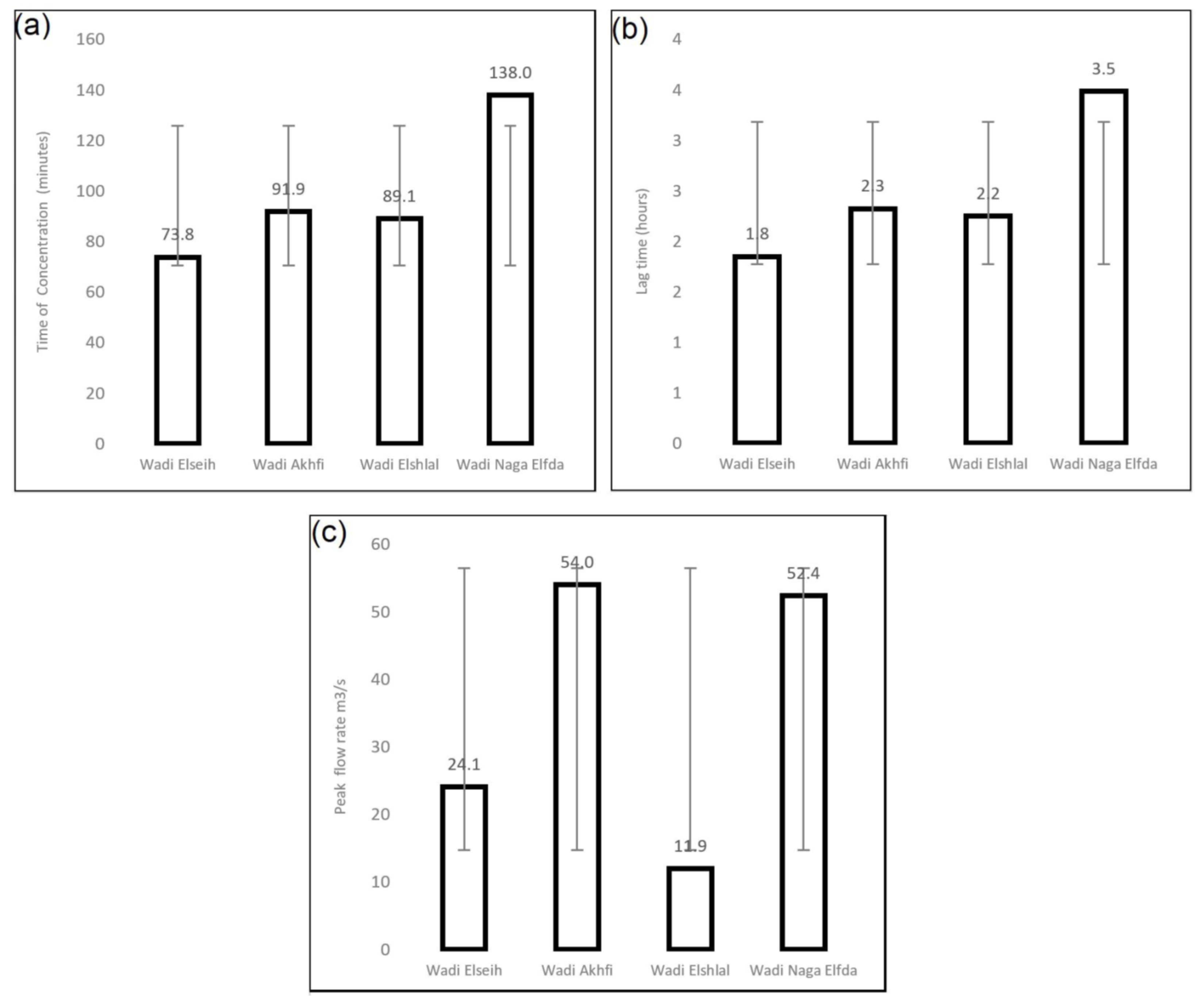
| Parameter/Sub-Basins | Wadi Elseih | Wadi Akhfi | Wadi Elshlal | Wadi Naga Elfda |
|---|---|---|---|---|
| Length of main channel (m) | 40,133.7 | 19,684.8 | 24,107.3 | 35,575.9 |
| Slope % | 0.82 | 0.11 | 0.18 | 0.13 |
| Time of Concentration | 73.8 | 91.9 | 89.1 | 138.0 |
| M (Constant) | 0.6 | 0.6 | 0.6 | 0.6 |
| L | 40.13370079 | 19.68475132 | 24.1072743 | 35.5759073 |
| Slope (Percent) | 81.80358131 | 11.15246043 | 18.12121966 | 12.67380984 |
| lag time | 1.8 | 2.3 | 2.2 | 3.5 |
| Area (A) km2 | 268.70 | 176.14 | 70.77 | 206.31 |
| Drainage Density (D) | 2.2 | 1.9 | 1.5 | 1.7 |
| Rain Depth (P) | 21.80 | 21.80 | 21.80 | 21.80 |
| Average of Slope (S) | 0.82 | 0.11 | 0.18 | 0.13 |
| Geology | 3.1 | 4.5 | 6.4 | 4.9 |
| R | 0.96 | 0.98 | 1.01 | 0.97 |
| Runoff Coefficient (C) | 1.54 | 5.06 | 2.78 | 4.19 |
| Runoff Volume (1000 m3/h) | 86.6 | 190.4 | 43.2 | 183.5 |
| Peak flow rate m3/s | 24.1 | 54.0 | 11.9 | 52.4 |
Publisher’s Note: MDPI stays neutral with regard to jurisdictional claims in published maps and institutional affiliations. |
© 2022 by the authors. Licensee MDPI, Basel, Switzerland. This article is an open access article distributed under the terms and conditions of the Creative Commons Attribution (CC BY) license (https://creativecommons.org/licenses/by/4.0/).
Share and Cite
Attia, W.; Ragab, D.; Abdel-Hamid, A.M.; Marghani, A.M.; Elfadaly, A.; Lasaponara, R. On the Use of Radar and Optical Satellite Imagery for the Monitoring of Flood Hazards on Heritage Sites in Southern Sinai, Egypt. Sustainability 2022, 14, 5500. https://doi.org/10.3390/su14095500
Attia W, Ragab D, Abdel-Hamid AM, Marghani AM, Elfadaly A, Lasaponara R. On the Use of Radar and Optical Satellite Imagery for the Monitoring of Flood Hazards on Heritage Sites in Southern Sinai, Egypt. Sustainability. 2022; 14(9):5500. https://doi.org/10.3390/su14095500
Chicago/Turabian StyleAttia, Wael, Dina Ragab, Atef M. Abdel-Hamid, Aly M. Marghani, Abdelaziz Elfadaly, and Rosa Lasaponara. 2022. "On the Use of Radar and Optical Satellite Imagery for the Monitoring of Flood Hazards on Heritage Sites in Southern Sinai, Egypt" Sustainability 14, no. 9: 5500. https://doi.org/10.3390/su14095500
APA StyleAttia, W., Ragab, D., Abdel-Hamid, A. M., Marghani, A. M., Elfadaly, A., & Lasaponara, R. (2022). On the Use of Radar and Optical Satellite Imagery for the Monitoring of Flood Hazards on Heritage Sites in Southern Sinai, Egypt. Sustainability, 14(9), 5500. https://doi.org/10.3390/su14095500