Abstract
The paper illustrates the enhancement of knowledge of architecture from 1945 onwards in Genoa by means of the publication on the Geoportal of the Municipality, which was developed with open-source systems, of a proper dataset and tools for digital storytelling for citizens. The implementation on the municipal Geoportal of a section called “Contemporary Architecture from 1945 onwards in Genoa” was made possible through collaboration between the University of Genoa Architecture and Design Department (DAD) and the Municipality of Genoa Office for Geographical Information Systems. The data related to the buildings in the Municipality of Genoa were extracted from a previous study about contemporary architecture in Liguria carried out by DAD. The case study introduced two tools for the promotion and enhancement of knowledge of such architecture, a map on which the buildings are located and associated with an information form and geostories with in-depth information on selected buildings, the latter of which can be sorted based on thematic itineraries or by author. The use of integrated services contributes to the competitiveness and sustainability of the city, raising citizens’ awareness of the value of the architecture of the second half of the 20th century and thus activating conservation processes as advocated in the Sustainable Development Goals of the United Nations General Assembly.
1. Introduction
According to Articles 1 and 6 of the Codice dei Beni Culturali e del Paesaggio (Cultural Heritage Code, Legislative Decree 42/2004) [1], knowing and understanding the values of cultural heritage constitute the first step for its conservation and valorisation.
This paper dealt with contemporary architecture built from 1945 onwards in Genoa, which represents a significant testimony of a complex historical period, a heritage that in Liguria includes well-known episodes alongside others almost unheard of.
The publication on the Geoportal of the Municipality of Genoa of a dataset on this architecture aimed to enhance this heritage. In particular, geostories were created as a tool to facilitate the understanding of information by, and increase the involvement of, citizens.
A collaboration between the University of Genoa Architecture and Design Department (DAD) and the Municipality of Genoa Directorate for Digitalisation Technologies and Smart City—Office for Geographical Information Systems aimed to disseminate and enhance the results of the study “Census and cataloguing of modern and contemporary architectural complexes in Liguria”. It was conceived, finalised, and implemented in the first phase by the General Directorate for Architecture and Contemporary Art [2] of the Ministry of Culture (MiC) and in a second phase by the Region of Liguria, the Regional Secretariat of the MiC for Liguria, and the then-Department of Architectural Sciences of the University of Genoa, today the Architecture and Design Department of the Polytechnic School of the University of Genoa, within the Framework Programme Agreement “Integrative Heritage and Cultural Activities III—intervention BF-10—Planning for the development of programmes of strategic value in the field of culture”.
The first result of the promotion and valorisation of the research among the scientific community and the citizenship was the publication of the volume “Architetture in Liguria dopo il 1945” [3]; the text, published in open access mode, can be downloaded from the website of Liguria Region [4] and from that of the Architecture and Design Department [5].
In June 2016, the prototype of smartphone application LigurArch900, developed in collaboration with the CNR Istituto di Linguistica Computazionale A. Zampolli (Pisa/Genova), was presented. The app was improved in the following year by the company Simarlab in cooperation with the Fondazione Ordine degli Architetti PPC di Genova (FOA.GE) and the Ordini degli Architetti di Genova, Imperia, La Spezia and Savona, which realised the application’s potential. The app, which can be downloaded freely for iOS and Android, allows users to create personalised itineraries of contemporary architecture in Liguria with different key queries (by name of the designer, type of use, urban location, and period of construction) and is periodically supplemented with new buildings on the basis of user suggestions assessed by a scientific committee made up of DAD teachers and representatives of FOA.GE.
The implementation of the Geoportal of the Municipality of Genoa, with a section called “Contemporary Architecture from 1945 onwards in Genoa”, through the publication of an Open Data dataset, was intended to enhance these architectural works in relation to other data already present in the portal for a more complete reading of the city. Moreover, the Geoportal offers, through geostories, in-depth information on selected buildings, which can be sorted based on thematic itineraries or by author.
The importance of publishing open data and digital storytelling to enhance the use, knowledge, and appreciation of cultural heritage at different levels has been highlighted by several studies [6,7,8,9]. Sharing and publishing cultural heritage information using integrated services developed through the collaboration between the ICT and heritage sectors contributes to the competitiveness and sustainability of cities [10,11].
2. Materials and Methods
2.1. Methodological Framework and Selection of Buildings
In the context of the broader research on contemporary architecture in Liguria from 1945 onwards, the first problem of a methodological nature that was tackled concerned the definition of criteria on the basis of which to identify and select works of significant historical–artistic interest (according to the definition in the Codice dei Beni Culturali e del Paesaggio, or Cultural Heritage Code, Legislative Decree 42/2004). These architectural works, which are worthy of attention, could in the future be the subject of possible protection or specific attention by urban planning instruments and building regulations to prevent future uncontrollable interventions from transforming them to the extent of making them ‘unrecognisable’ or even demolishing them, given the absence of any specific direct or indirect legislative protection.
In order to define the criteria for identifying the works, the working method developed by Service V of the former Ministry for Cultural Heritage and Activities (MiBAC), now MiC, which is available on the Ministry’s website, was used [12]. The criteria were partly quantitative (e.g., bibliographic recurrence) and partly critical (e.g., capacity for technological innovation, renewal of typological schemes, solution of technical or social problems).
The historical–critical value of a work was therefore defined, independently of its critical fortune, in other and more articulated criteria. The binomial “historical” and “artistic”, to which the Cultural Heritage Code refers, has been discussed by separating the two terms and specifying, for each of them, possible selection criteria, albeit with awareness of how difficult and even “contestable” this passage is, even for the already fundamental reflections of Alois Riegl in the early twentieth century [13].
As regards the assessment of the artistic value of an architecture, reference was made to a criterion of an essentially bibliographical nature, i.e., its documented and documentable critical fortune, which can be deduced from existing literature and publications, both specialist and generic and/or popular. In order to understand whether or not a building or an architectural and urban complex was of historical importance, even if recent or very recent, it was decided to place it in the relative context of direct, but more general, historical reference.
The urban, architectural, and building history of Liguria was divided into four periods:
- 1945–1959, the years of the reconstruction;
- 1960–1979, the years of the economic boom and great urban expansion;
- 1980–1989, the years of the implementation of major architectural urban and territorial projects;
- 1990–2015, the years of the requalification of the existing city and the contemporary world.
The heritage of the second half of the 20th century was also subdivided and classified within each historical phase into different functional typologies, in most of cases with still-current uses (thus making a distinction between original uses and the situation today):
- Museum buildings, public buildings;
- buildings for worship;
- school complexes of all grades;
- high-density residential settlements;
- private villas;
- tourist settlements;
- hospitals;
- buildings for the tertiary sector.
It was then considered necessary to specify the criteria for identifying the possible critical interest within each period according to different points of view and disciplinary, cultural, and technical perspectives, noting, for each work surveyed:
- The relevance of the designer also regardless of the critical acclaim of the single work;
- the building types and the ways in which buildings are used, also considering some particular innovations in the relationship between the creation of space and its perception;
- the relevance and significance of the work for the reference social community or in the Italian and international cultural debate;
- the relationship with the urban or landscape and environmental context;
- the evolution of construction logics and principles and the use of innovative materials for the period.
The next step was the identification of reasons for cultural “interest” in the architectural works, based on the criteria already described and on indices of “cultural significance/interest/representativeness” attributed to the works already identified. This was done to further select buildings and complexes to be analysed and described in deeper detail and to be included in the regional information system on cultural heritage. The works were “weighted” according to three levels of importance identified by the numbers 1, 2, and 3. The weight was attributed on the basis of the following reasons:
- Level 1: the author’s notoriety, critical acclaim, and relevance to the disciplinary and cultural debate, besides possible motivations of critical interest;
- Level 2: the presence of one or two of the criteria of historical–artistic interest together with one or more of the reasons of critical interest;
- Level 3: the presence of at least one of the reasons of critical or historical–artistic interest.
In addition, all the architectural works that were already listed were chosen for further study. The selection also considered a criterion of homogeneity and balance among the different historical reference periods, as well as geographical location.
2.2. Building Digital Archives
One of the results of the research was a census of about 500 buildings spread over the Ligurian territory, with personal and descriptive files articulated according to the catalographic criteria of the Istituto Centrale per il Catalogo e la Documentazione (ICCD, Central Institute for the Cataloguing and Documentation) of the Ministry of Culture, Records A.
Already in the early stages of the research, a relational database linked to a geographic information system (GIS) was set up to store information about the selected buildings. For each building, the following data were archived:
- Identification code;
- name of the work;
- location (province, municipality, town, address);
- current property;
- type (this field contained specifications on the uses and different typologies traditionally associated with the morphology of the building and its internal distribution);
- current use;
- name of the main designer;
- name of the related designers;
- start and completion dates of the project;
- start and completion dates of the building work;
- bibliographic references;
- consulted websites references;
- presence of protection restrictions or declarations of interest;
- reasons for the choice (coexistence of one or more criteria identified for a possible historical–critical interest of the work);
- value assignment (based on levels and criteria).
Several buildings were chosen for the printed publication [3], in which some of the data collected were enriched with maps produced in a GIS environment for the location of the buildings and with descriptive texts for the most significant ones.
Among the primary goals of the research were the dissemination and exploitation of the results. These were carried out through the creation of the LigurArch900 application, which allows the user to view the surveyed buildings on georeferenced maps, consult a selection of associated information, and create customised itineraries.
2.3. The Contemporary Architecture in Genoa from 1945 Onwards
A total of 210 buildings were registered in the Municipality of Genoa, distributed as follows, according to the four aforementioned historical periods:
- 1945–1959: 60 buildings;
- 1960–1979: 67 buildings;
- 1980–1989: 35 buildings;
- 1990–2015: 48 buildings.
Although in the selection of the buildings an attempt was made to keep a balanced distribution among the different periods, it is impossible to deny the great building impulse given by the postwar reconstruction and the economic boom of the 1960s. The former period focused mainly on residential buildings, both private and public, and on offices in order to meet a demand for housing for workers, and the latter focused mainly on the renovation of the historic city. In later periods, however, more space was reserved for urban interventions, the construction of services, and the rethinking of the post-industrial crisis city.
Interpreters of contemporary architecture in Genoa have been both local and external designers; in this regard, it should be remembered that the University of Genoa started the complete cycle of the Faculty of Architecture only in the early 1970s, and therefore, for the training of local architects, reference must be made mainly to the Milanese and Roman schools. The most prolific local architect is Luigi Carlo Daneri, who designed 21 of the selected buildings, followed by Piero Gambacciani (15), Aldo Luigi Rizzo (13), and Robaldo Morozzo della Rocca (10), all three Genoese by adoption, and Marco Dasso (5), Giuliano Forno (4), and Studio Mor e Sibilla (4). Ignazio Gardella, born in Milan to a family of engineers and architects of Genoese origin, kept his studio in the Lombard capital but was also active in Liguria, designing numerous projects in the Arenzano Pinewoods; eight of his works were selected in Genoa. The external designers included Franco Albini (6) and Luigi Caccia Dominioni (4), both from Milan, who also designed residential projects on the two Ligurian Rivieras.
In more recent times, the main figure in the architectural production in Genoa was undoubtably Renzo Piano, who designed 11 of the projects listed, mainly related to the redevelopment of the Porto Antico and the underground railway project.
As far as types of use are concerned, the most common type of architecture surveyed in Genoa was residential (about 34%), followed by offices, infrastructure, education, and churches or places of worship (more than 10), demonstrating the great importance of housing in the second half of the 20th century, even to the detriment of the city’s liveability (Figure 1).
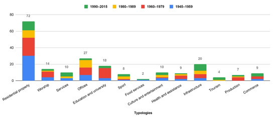
Figure 1.
The graph represents the distribution of the architectural works registered in the Municipality of Genoa according to the prevailing types of use; the four colours in each column identify works belonging to each of the four historical periods defined in Section 2.1.
2.4. Geoservices for the Citizen
The Geoportal of the Municipality of Genoa [14] is not only a tool to support administrative and political decisions but a service for citizens. Through the catalogue or prebuilt thematic maps, the geoportal offers the possibility of consulting more than 300 levels of territorial and environmental information of the authority. In addition, many datasets are published in open data formats.
This technologically complex tool, articulated on many application layers and on many development technologies in an open-source environment, is included in the Multiannual IT Plan and in the PON METRO Project—Digital Agenda of the Municipality of Genoa.
The Geoportal allows the user to navigate on maps and superimpose layers by linking spatial data from other catalogues as well as providing 2D and 3D visualisation services and data downloads in different formats. In each map, it is possible to insert any level of data contained in the catalogue of the Municipality of Genoa and made public, but also external services provided by other bodies (Liguria Region, Metropolitan City, and others). For each level, it is possible to consult the attribute table and carry out searches and filters on one or more fields. The Geoportal, through the activation of geoservices, allows the direct use and downloading of data related to the information layers of municipal cartography (Open GIS Consortium standard services WMS—Web Map Service and WFS—Web Feature Service) [15]. It also implements the National Directory of Spatial Data (RNDT), established by article 59 of the Digital Administration Code (Legislative Decree 82/2005 and subsequent amendments and additions), which is the national catalogue of all metadata concerning spatial data and related services available in the Public Administrations, and acts as a public register of such data, certifying their existence through the publication of metadata. As a result, it provides the national search service for the implementation of the INSPIRE directive, as regards spatial metadata, also through the RNDT.
The Geoportal of the Municipality of Genoa was developed in open-source logic and consists of various components including Mapstore, Geonetwork, and Geoserver.
Mapstore [16] allows queries to be made using the attribute filter, drawing an area on the map (filtering by area of interest) or filtering the data of the chosen layer with those of another on the map (filtering using a layer). Users can also create widgets (graphs, texts, tables, and counters) that serve to describe and display the data of a layer qualitatively and quantitatively and provide the user with the possibility of analysing the information more effectively.
Among the contents of the Geoportal of the Municipality of Genoa, geostories have also been implemented: they allow improving and integrating the use of one or more maps by combining texts, images, and videos. Geostories are an important tool for communicating map contents and have been used by several public administrations in Italy and abroad [16,17,18,19,20].
In the tool Story, it is possible to add sections within the Container area by choosing from the following types: Title, Banner, Paragrafh, Immersive, GeoCarousel, Media, and Webpage. In the governmental sphere, the Story tool is effective at highlighting, presenting, and communicating to citizens and possible stakeholders what has already been achieved or is to be achieved with new projects in the city. The geostory (or story map) is a data journalism and storytelling tool that combines data and maps. It is like an interactive and narrative article, telling with data in hand and integrated maps what actions have been taken and what the characteristic elements are in one’s own territory or city or in a specific area. A story told about all the work done is like a report of the actions undertaken, which, through descriptive logic in blog style, allows the user to be led through the different sections of the site. The following can be integrated into the site:
- Interactive maps, which, through keywords in the text written in the article, can locate the user at the key points on the map;
- data, which help build geostatistics;
- interactive graphs, which can be linked to the maps;
- films, as promotional spots;
- articles.
The Municipality of Genoa has designed several geostories, which will soon be published on the Geoportal.
A review of the websites of the Italian regional county seats showed that all of them were equipped with a geoportal for map consultation, while only two, apart from Genoa, had developed interactive multimedia contents through geostories. In particular, the cities of Milan and Cagliari developed Storymaps based on Esri’s proprietary technology, achieving the objective of making topics of architectural or touristic interest more accessible [21,22].
The Municipality of Genoa instead chose open-source tools with the undeniable advantage of making the source code available for acquisition and reuse by other organisations, both public and private, in line with the central government’s indications.
Any stakeholder can access and reuse the provided geospatial tools and their platforms without having to reinvest economic resources in the development of new ones.
The experimentation carried out in this research has enabled not only the creation of a tool aimed at communicating with various stakeholders but the development of a new model that can be scaled up and replicated in other regions and cities at both regional and national level.
The data related to the research on contemporary architecture built from 1945 onwards in Genoa are actually a public information heritage. Making these data available in an open format through standard and interoperable digital services can lead to a model of the city according to a data governance logic that allows decisionmakers to take data-driven actions according to the data-driven and data economy models outlined in the European Data Strategy and European Directive 2019/1024 [23].
2.5. Three-Dimensional Visualisation of the City of Genoa
During 2018, the Municipality of Genoa equipped itself with an accurate survey of the city that allowed an initial reconstruction in three-dimensional form through Lidar technology and the photogrammetric use of aerial images. In 2021, high-resolution oblique images of the built-up part of the city were acquired, enabling the creation of a 3D viewer that will be available within the Geoportal [24,25]. On the one hand, this technology makes it easier for nonexperts to understand the morphology of such a complex city; on the other, it allows knowledge and conservation technicians to carry out precise measurements, as well as providing the not inconsiderable possibility of superimposing additional geographical levels available from municipal, regional, and national geoservices. The reading of the territory therefore led to new tools for the interpretation of future and past phenomena. The future possibility of integrating part of the HBIM models into Genova 3D will allow new developments from the point of view of popular and informative communication.
The implementation and integration of the 3D survey and 3D visualisation/navigation services within the Geoportal will enable greater widespread knowledge in the field of architectural conservation. With this in mind, using the various tools in the viewer, it will be possible to interrogate each element (building materials, fixtures, etc.) of the model stored in a BIM system in relation to the context of the spatial databases in which it is located. This will allow a designer to better evaluate possible interferences with the built environment and to harmoniously integrate the project with the urban fabric.
Three-dimensional visualisation provides a new perspective through integrated navigation of various geographical databases made accessible in the geoportal catalogue.
Thus, users can generate mashups of digital twins by inserting virtual or planned elements and visualising them in the context of the real city in the Geoportal.
3. Results
3.1. Geoportal and Architectural Works of the Second Half of the 20th Century
Data relating to the buildings in the Municipality of Genoa were extracted from a database of the research on contemporary architecture in Liguria (Figure 2) and shared with the Territorial Information Systems Office of the Municipality, which produced a map published on the Geoportal. The data made available were:
- Identification code;
- name of the work;
- localisation (province, town, municipality, number, and address);
- current property;
- type of use;
- current use;
- main designer;
- other designers;
- design start date;
- completion of work date;
- geographical coordinates;
- period;
- description;
- bibliography;
- author of the pictures.
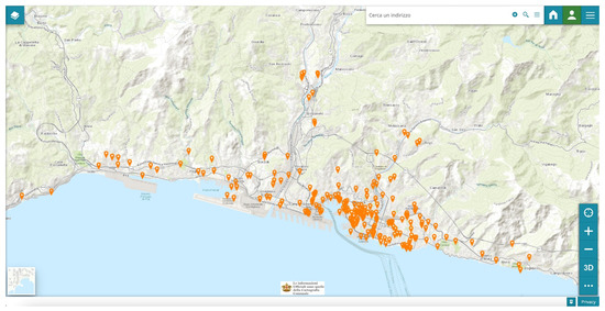
Figure 2.
Screenshot of the Geoportal of the City of Genoa showing the map of the “Contemporary Architecture from 1945 onwards in Genoa” and the location of the 210 surveyed and selected buildings in the City of Genoa.
The enquiry form (Figure 3), available in two languages (Italian and English), allows visualising, for the selected building, one or more photographs in carousel mode, in addition to the data listed above, and is a tool with great popular and tourist value. The Geoportal allows users to create graphs, tables, and counters to analyse the information more effectively through a spatial query (Figure 4).
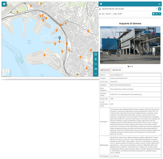
Figure 3.
Identification of a building on the map and consequent opening of the query form containing information in two languages.
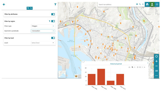
Figure 4.
The data in the attribute table can be filtered or represented graphically using widgets. The histogram shows the construction periods of a selection of buildings identified by a spatial query using the polygon tool (the polygon is visible on the map with a yellow border).
By combining these data with others already present in the Geoportal, it is possible to read exhaustive historical or tourist information and create itineraries according to the specific interests of the user.
The implementation and publication of these maps allowed the Genoese Administration to achieve one of its recent objectives: to broaden the city’s cultural and tourist offer in order to make people aware of Genoa’s whole cultural heritage beyond its main attractions.
Thanks to the interoperability of the service, users can share information by downloading data in vector format (shape, geojson, dxf) or by linking it to their own applications or portals according to the Open Geospatial Consortium (OGC) standards in WFS (Web Feature Service) or WMS (Web Map Service) format.
The provided layers constitute information flows in an interoperable system that guarantees correct interaction of information and data between the Public Administration actors and other users, such as the University of Genoa, by using international standards. Interoperability is indispensable to enable digital transformation. The information flows generated by the publication of these maps are a factor of economic growth for companies using the value-added databases. For example, in the case of maintenance, renovation, or reuse of these buildings, the data can be used as an information flow for a georeferenced BIM or HBIM project. The additional value obtained through the georeferencing of these projects will be also economic, with a return to the Public Administration through GIS–BIM data integration for the implementation of digital twins and their governance (Figure 5).
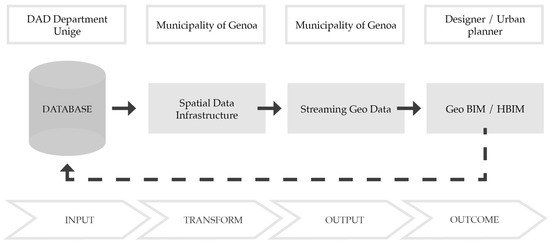
Figure 5.
Geo Data Flow.
The Municipality of Genoa has undertaken a program in which all urban planning interventions must be presented through the Geoportal in a 3D visualisation of the different work phases. Both the “as is” and the “to be” phases must be presented to the citizenry with renderings of the project integrated into the 3D city built with real, measurable, and georeferenced data.
This program was oriented to realise a digital twin as an urban planning tool that employs new international standard formats such as Citygml and Cityjson.
3.2. Geostory of Residential Architecture after 1945 in the Eastern Part of Genoa
The geostory “Residential architecture after 1945 in the eastern part of Genoa” was structured in sixteen sections and was dedicated to the narration of an itinerary composed of a selection of important residential buildings along the eastern coast of Genoa, from the mouth of the Bisagno stream to Albaro district. This geostory was an example used to illustrate the structure and potential of the tool. In order to enhance the city’s architectural heritage, it will be necessary to create other geostories following different thematic itineraries.
The geostory was developed using MapStore’s Story tool, which enables the creation of immersive stories combining maps with text, video, and images to implement the usability of the maps.
Narration through geostory enables the integration of a theme into a wider context. Using new, innovative technological tools available on tablet and mobile phone, it is possible to reach a wider audience by spreading knowledge.
The geostory “Residential architecture after 1945 in the eastern part of Genoa” was designed with three general sections with an introductory character and three other sections that were repeated for each building. The video is played automatically if one enables the Autoplay option and continues to repeat if one enables the Loop option (Figure 6).
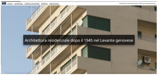
Figure 6.
View of the first section of the geostory with the title and the video showing images of the architectural works of the itinerary. At the moment, the geostory is available only in Italian.
The second, immersive section can be viewed by scrolling down or selecting it from the horizontal menu. The first map and a brief description of the itinerary are inserted. The map shows the tags of the chosen buildings and the route; if one clicks on a tag, a sheet with the building’s data opens (Figure 7).
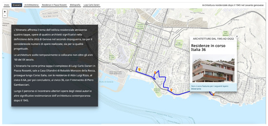
Figure 7.
View of the second section of the geostory with the map of the itinerary and its description. When one clicks on the tags on the map, the building sheets open.
The third section contains the 3D visualisation of the city of Genoa, within which it is possible to navigate and view the volume of the buildings (Figure 8).
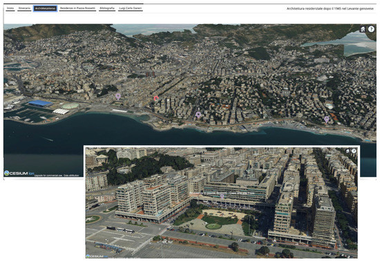
Figure 8.
View of the third section of the geostory with the navigable 3D visualisation of the city.
The next sections contain specific information about the buildings and their designers, organised in three consecutive sections, two of immersive type and one of paragraph type. The first contains the second map of the Geostory, zoomed in on the building, the outline of which is highlighted with a blue polygon, and an immersive content with the name of the building, the designer, the reference dates, a descriptive text, and a video with photographs of the exterior that is automatically played in a loop (Figure 9). The second section contains the bibliography of the building. The third section shows the third map of the Geostory in the background and an immersive content dedicated to the designer. This map shows all the buildings that the architect designed and realised in Genoa and that were included in the census, while the box above displays a text with a short biography of the author (Figure 10).
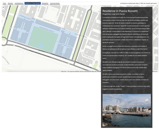
Figure 9.
View of the first section of the geostory regarding the first building. The map is zoomed on the Residences in Rossetti Square; a description and a photo are inserted in the text box.
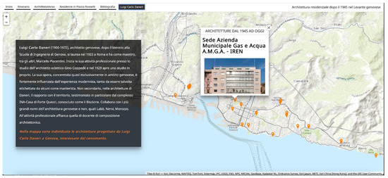
Figure 10.
View of the third section of the geostory regarding the first building: the map shows the buildings designed by Luigi Carlo Daneri, and a short biography of the architect is included in the box.
The itinerary deals with the theme of multifamily residential construction by private initiative through four stops corresponding to the works of four architects, Genoese by birth or adoption, who were significant in the definition of the city after the Second World War, both for the considerable number of works they built and for the quality of their designs. The buildings chosen date no later than the 1960s and reflect the research on the theme of housing in that historical period, both nationally and elsewhere.
The itinerary starts with Luigi Carlo Daneri’s complex in Piazza Rossetti (1934–1958), the first steps of which were taken in the 1930s in implementation of the master plan for the area at the mouth of the Bisagno stream. The project, of urbanistic importance, reflects the author’s strong modernist matrix [26,27].
The second stop is Robaldo Morozzo della Rocca’s Casa Ollandini (1956–1963), set in a panoramic position, the particular shape of which evokes the state of the preexisting neo-Gothic villa partially torn apart in one corner following the bombings. This reflects the client’s relationship and feelings towards it [28,29].
The itinerary continues along the seafront promenade of Corso Italia, where one first comes across the residences designed by Aldo Luigi Rizzo at numbers 6 and 6A. The promenade ends at number 36 with an intervention by Piero Gambacciani.
The first of these (1963) were built in a raised position and reflect Rizzo’s style of architecture, characterised by horizontal and vertical lines and the chromatic contrast between the materials. The latter of these, in this specific case, dialogues with the nearby Villa Chiossone, which is characterised by its extensive use of stone and brick materials [30]. Gambacciani’s project (1960), on the other hand, is dominated by horizontality, with two large glass overhangs and a wall separating it from the street cut by a continuous window; the skilful use of materials emphasises the interaction of volumes and surfaces.
Other works by the same authors and other significant examples of contemporary architecture that were catalogued as part of the research are to be found along the way.
Among the possible evolutions of this experimentation is the creation of links with digitised documentary and bibliographical contents, such as archives and magazines.
4. Discussion and Conclusions
The paper illustrates the first results of the collaboration between the University of Genoa Architecture and Design Department and the Municipality of Genoa Directorate for Digitalisation Technologies and Smart City—Territorial Information Systems Office. The results consist in the publication, on the municipal Geoportal, of a new informative layer dedicated to contemporary architecture, which can be consulted and downloaded, but with which it is also possible to interact through engaging tools such as geostories.
The goals of this collaboration were twofold: on the one hand, the dissemination and valorisation of the results of ten years of research on contemporary architecture in Liguria, and on the other hand, the expansion of the catalogue of services offered by the geoportal with information on cultural heritage.
The use of integrated services contributes to the competitiveness and sustainability of the city. Collaboration between the ICT and cultural heritage sectors is crucial for the innovation of services for citizens and professionals.
The adoption of open-source systems, such as MapStore, Geoserver, and Geonetwork, in the Public Administration responds to the indications of the Digital Administration Code and makes the same model sustainable, reusable, and replicable in other territorial entities (Municipalities, Metropolitan Cities...). These technological systems constitute the components of the territorial data infrastructures and make it possible to build and enrich the digital twin to plan and monitor changes in the cities.
In addition, the use of open-source systems allows for greater replicability of the workflow tested here and the adaptation of the tools to the needs of the users, making possible to obtain a product that adheres to their needs.
Digital storytelling tools and services provide the opportunity to redesign the sharing of digital heritage data in order to attract the public, discover a diverse digital offer, provide necessary elements for a future visit, and enable the use of architecture through an immersive and content-rich experience.
Digital storytelling enriches the physical space and the experience of its use by sharing data and information that change the perception of cultural heritage, thus promoting accessibility to new users. The recent pandemic has also given significant impetus to the development of e-tourism.
The experience presented in this paper aligns with the Sustainable Development Goals (SDGs) adopted by the General Assembly of the United Nations on 25 September 2015 [31]. Goal 11 aims to “make cities and human settlements inclusive, safe, resilient and sustainable” and, particularly at 11.4, to “strengthen efforts to protect and safeguard the world’s cultural and natural heritage”. Raising citizens’ awareness of the value of the architecture of the second half of the 20th century can activate conservation processes of this heritage.
The collaboration between the two institutions involved, thanks to the sharing of their respective knowledge and skills, enabled the application of the geostories tool to research on contemporary architectural heritage. The use of geostories broadens the range of tools available for the valorisation of cultural heritage. The results of the research on contemporary architecture in Genoa were disseminated in different ways: first, through the publication of an open access book; second, through the development of a mobile application; and third, through publication on the geoportal. Each of these tools has its own strengths and limits. In particular, the publication on the Geoportal allows reaching a wide and heterogeneous audience by addressing the citizenry, while the book has a mainly academic and specialist circulation, and the app was created and promoted for architects. The Geoportal allows the downloading of data and thus their immediate reuse by users. Although consulting the data on the Geoportal is relatively simple, it requires the user to have basic computer skills.
The experimentation referred to the research carried out on contemporary architecture, but the proposed methodology can also be applied to other themes, such as those related to the historical centre or rural heritage. The Municipality of Genoa has been at the forefront of the development of geoinformatic tools for several decades, and in particular, in recent years, of the publication of open-access data. This experience testifies to the Municipality of Genoa’s desire to bring together in a single repository the results of scientific research carried out by various bodies (universities, cultural institutes, etc.).
Geoportals were born and are used first and foremost as tools for consulting and distributing cartographic products and information on regulatory provisions and land planning and management, from a cultural as well as other points of view [32,33].
The experience illustrated in this paper fit into the current trend of using webGIS for the transmission of cultural content and scientific research results [34,35]. This tool, applicable to different levels and disciplinary fields, proved to be strategic for more complete and richer comprehension of the territory in which we live and which we have to manage thanks to the possibility of simultaneously overlapping and reading multidisciplinary information.
The Cultural Heritage Code, in article 1, paragraph 3, identifies municipalities as the bodies that must promote the public use and enhancement of cultural heritage. The project illustrated in this paper was intended to promote the knowledge of a diffuse heritage and was also aimed at its valorisation and conservation, as well as being the starting point for further collaboration between the bodies involved.
Author Contributions
Conceptualisation and methodology, M.C., S.A, S.F.M. and S.T.; software, S.T., F.R. and C.O.; investigation, M.C., S.A. and S.F.M.; writing—Section 1, Section 2.1, Section 2.2, M.C., S.A. and S.F.M.; writing—Section 2.3, S.A.; writing—Section 2.4, M.C., S.T., F.R. and C.O.; writing—Section 2.5, S.T., F.R. and C.O.; writing—Section 3.1, M.C.; writing—Section 3.2, M.C. and S.A.; writing—Section 4, M.C., S.A. and S.F.M. All authors have read and agreed to the published version of the manuscript.
Funding
The research “Census and cataloguing of modern and contemporary architectural complexes in Liguria”was originally funded by the Ministry of Culture (MiC) and in a second phase by the Region of Liguria.
Data Availability Statement
The data presented in this study are available upon request from the corresponding author.
Conflicts of Interest
The authors declare no conflict of interest.
References
- Cultural Heritage Code. Available online: https://www.beniculturali.it/mibac/multimedia/MiBAC/documents/1226395624032_Codice2004.pdf (accessed on 30 March 2022).
- Atlante Architettura Contemporanea. Available online: https://www.atlantearchitetture.beniculturali.it (accessed on 29 March 2022).
- Musso, S.F.; Franco, G. Architetture in Liguria Dopo Il 1945; De Ferrari: Genoa, Italy, 2016. [Google Scholar]
- Regione Liguria. Available online: https://www.regione.liguria.it/homepage/cultura1/progetti-pubblicazioni/progetti-conclusi/architettura-moderna-contemporanea.html (accessed on 22 March 2022).
- Architettura Unige. Available online: https://architettura.unige.it/node/1268 (accessed on 22 March 2022).
- Brouillard, J.; Loucopoulos, C.; Dierickx, B. Digital storytelling and cultural heritage: Stakes and opportunities. In Report of AthenaPlus WP5 “Creative Applications for the Reuse of Cultural Resources”; Officine Grafiche Tiburtine: Rome, Italy, 2015. [Google Scholar]
- Villa, D. (Ed.) Open Data for Cultural Heritage. Place Based Digital Humanities between Representation, Design and Innovation; Planum Publisher: Milan, Italy, 2015; pp. 15–20. [Google Scholar]
- Zakrajsek, F.J.; Vodeb, V. eCultureMap: How cultural institutions can benefit from geolocalised content. In Report of AthenaPlus WP6 “Pilots for Testing the Creative Use of Cultural Contents”; Officine Grafiche Tiburtine: Rome, Italy, 2015. [Google Scholar]
- Vedoà, M. The Narration of Cultural Landscape as a Mean for Reactivating Marginal Areas. In Connecting. Drawing for Weaving Relationships; Arena, A., Ed.; Franco Angeli: Milan, Italy, 2020; pp. 3827–3834. [Google Scholar]
- Paskaleva, K.A.; Azorin, J.A. Developing Integrated E-tourism Services for Cultural Heritage Destinations. Int. J. Serv. Technol. Manag. 2010, 13, 247–262. [Google Scholar] [CrossRef]
- Kalvet, T.; Olesk, M.; Tiits, M.; Raun, J. Innovative tools for tourism and cultural tourism impact assessment. Sustainability 2020, 12, 7470. [Google Scholar] [CrossRef]
- Architetture del Secondo Novecento. Available online: http://www.architetturecontemporanee.beniculturali.it/architetture/index_metodologia.php (accessed on 29 March 2022).
- Riegl, A. Der Moderne Denkmalkultus. Sein Wesen und Seine Entstehung; Verlage Von W. Braumüller: Leipzig, Austria, 1903. [Google Scholar]
- Geoportale del Comune di Genova. Available online: https://geoportale.comune.genova.it (accessed on 22 March 2022).
- Garassino, R.; Bertini, D.; D’Orazi, M. L’aspetto digital della Smart City: Il Geoportale del Comune di Genova. Impresa Progett. -Electron. J. Manag. 2014, 4, 1–11. [Google Scholar]
- Mapstore.readthedocs.io. Available online: https://mapstore.readthedocs.io/en/latest/user-guide/home-page/ (accessed on 22 March 2022).
- Babbini, L.; Cipolloni, C.; De Croso, S.; Munafò, M.; Pasquale, A.; Vaccaro, L. EcoAtl@nte-le Story Map per mettere i dati ambientali al servizio del Cittadino. In Proceedings of the Conferenza Esri Italia, Rome, Italy, 10–14 May 2021. [Google Scholar]
- Cipolloni, C.; Annis, A.; Babbini, L.; Rapaccini, M.; Spasiano, A.; Nardi, F.; Monacelli, G. Modelli innovativi di comunicazione basati su WebGIS per il coinvolgimento dei cittadini: Il caso di studio del progetto INFO/RAC dell’UNEP-MAP. In Proceedings of the XXIII Conferenza Nazionale ASITA, Trieste, Italy, 12–14 November 2019. [Google Scholar]
- Oubennaceur, K.; Chokmani, K.; El Alem, A.; Gauthier, Y. Flood Risk Communication Using ArcGIS StoryMaps. Hydrology 2021, 8, 152. [Google Scholar] [CrossRef]
- Lafrenz Samuels, K.; Platts, E.J. An Ecolabel for the World Heritage Brand? Developing a Climate Communication Recognition Scheme for Heritage Sites. Climate 2020, 8, 38. [Google Scholar] [CrossRef] [Green Version]
- Geoportale del Comune di Milano. Available online: https://geoportale.comune.milano.it/sit/storymaps/ (accessed on 30 March 2022).
- Geoportale del Comune di Cagliari. Available online: https://geoportale.comune.cagliari.it (accessed on 30 March 2022).
- Direttiva UE 2019/1024. Available online: https://eur-lex.europa.eu/legal-content/IT/TXT/PDF/?uri=CELEX:32019L1024&from=ES (accessed on 30 March 2022).
- D’Orazi, M.; Garnero, G.; Traverso, S.; Vertamy, E. La nuova base dati geografici del Comune di Genova: Aspetti innovativi e applicazioni. In Proceedings of the XXV Conferenza Nazionale ASITA, Genoa, Italy, 15–18 June 2021. [Google Scholar]
- D’Orazi, M.; Garnero, G.; Traverso, S.; Vertamy, E. The New Geodatabase of the Municipality of Genoa: Innovative Aspects and Applications. In Geomatics and Geospatial Technologies. ASITA 2021. Communications in Computer and Information Science; Borgogno-Mondino, E., Zamperlin, P., Eds.; Springer: Cham, Switzerland, 2022; Volume 1507. [Google Scholar] [CrossRef]
- Patrone, P.D. Daneri; Sagep: Genoa, Italy, 1982; pp. 14–16. [Google Scholar]
- Brandolisio, M.; Vido, M. Luigi Carlo Daneri. Edifici alla Foce Bisagno—Genova. Domus 1990, 718, 80–88. [Google Scholar]
- Fierro, C. Robaldo Morozzo Della Rocca Architetto. Frammenti D’archivio 02; De Ferrari: Genoa, Italy, 2013. [Google Scholar]
- Oddone, L. La Villa Ollandini a Genova. L’Architettura. Cronache E Stor. 1958, 37, 454–457. [Google Scholar]
- Bona, E.D.; De Momi, P. Aldo Luigi Rizzo, Percorsi di Architettura. 1957–1983. Progetti Dello Studio A. Pino e A.L. Rizzo; Costa & Nolan: Genoa, Italy, 1986; pp. 15–55. [Google Scholar]
- 70/1. Transforming Our World: The 2030 Agenda for Sustainable Development. Available online: http://www.un.org/ga/search/view_doc.asp?symbol=A/RES/70/1&Lang=E (accessed on 22 March 2022).
- Vincoli in Rete. Available online: http://vincoliinrete.beniculturali.it (accessed on 30 March 2022).
- Fiorani, D.; Cacace, C. La Carta del Rischio come strumento di gestione conservativa dei centri storici. ArcHistoR Un Paese Ci Vuole. Studi E Prospett. Per I Cent. Abbandonati E Via Di Spopolamento 2020, 7, 1543–1563. [Google Scholar] [CrossRef]
- Patrimonio Culturale Dell’Emilia-Romagna. Available online: https://www.patrimonioculturale-er.it/webgis/ (accessed on 30 March 2022).
- Magrini, S. WebGIS, Cultural Heritage, Preservation, Tourism and the Wiki World: A Case Study from Emilia Romagna (Italy); EUM: Genoa, Italy, 2018; Volume 9, pp. 159–166. [Google Scholar] [CrossRef]
Publisher’s Note: MDPI stays neutral with regard to jurisdictional claims in published maps and institutional affiliations. |
© 2022 by the authors. Licensee MDPI, Basel, Switzerland. This article is an open access article distributed under the terms and conditions of the Creative Commons Attribution (CC BY) license (https://creativecommons.org/licenses/by/4.0/).