
Towards Conserving Crop Wild Relatives along the Texas–Mexico Border: The Case of Manihot walkerae


 ,
, 

Abstract
:1. Introduction
2. Materials and Methods
2.1. Model of Potential Distribution
2.2. IUCN Assessment
2.3. Mexico’s National Risk Assessment Method (MER)
3. Results
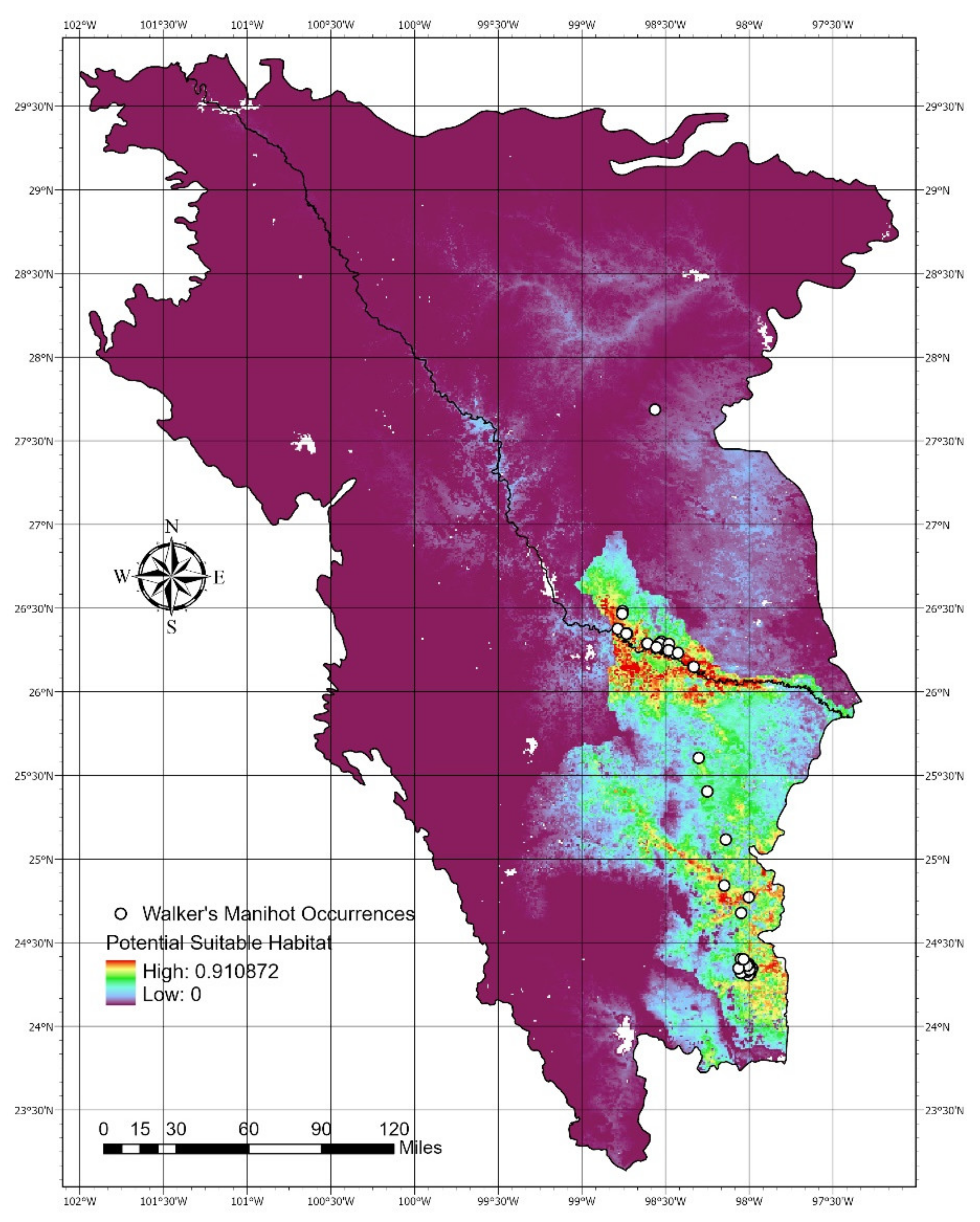
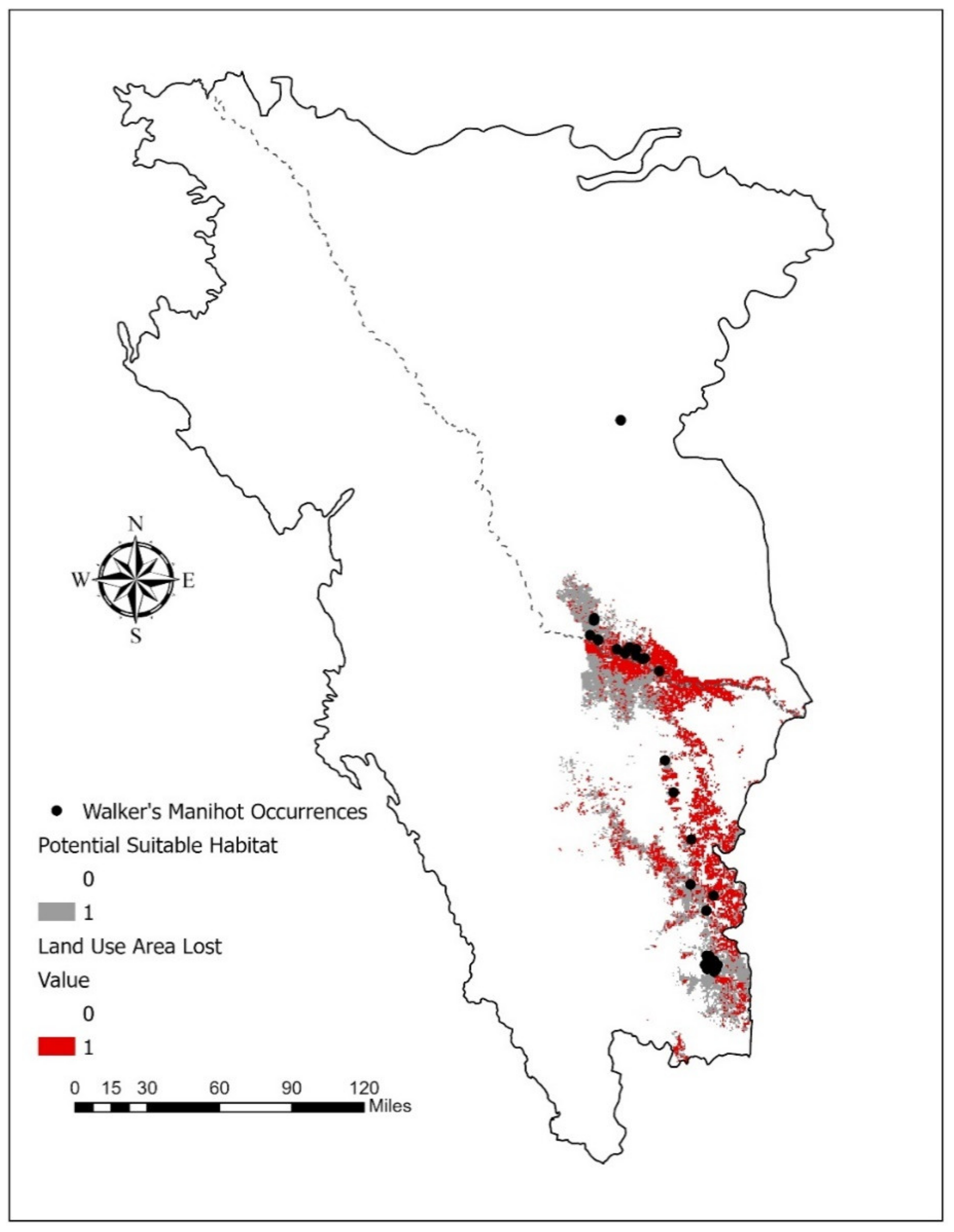
3.1. Result: Manihot Walkerae’s Potential Geographic Distribution Model
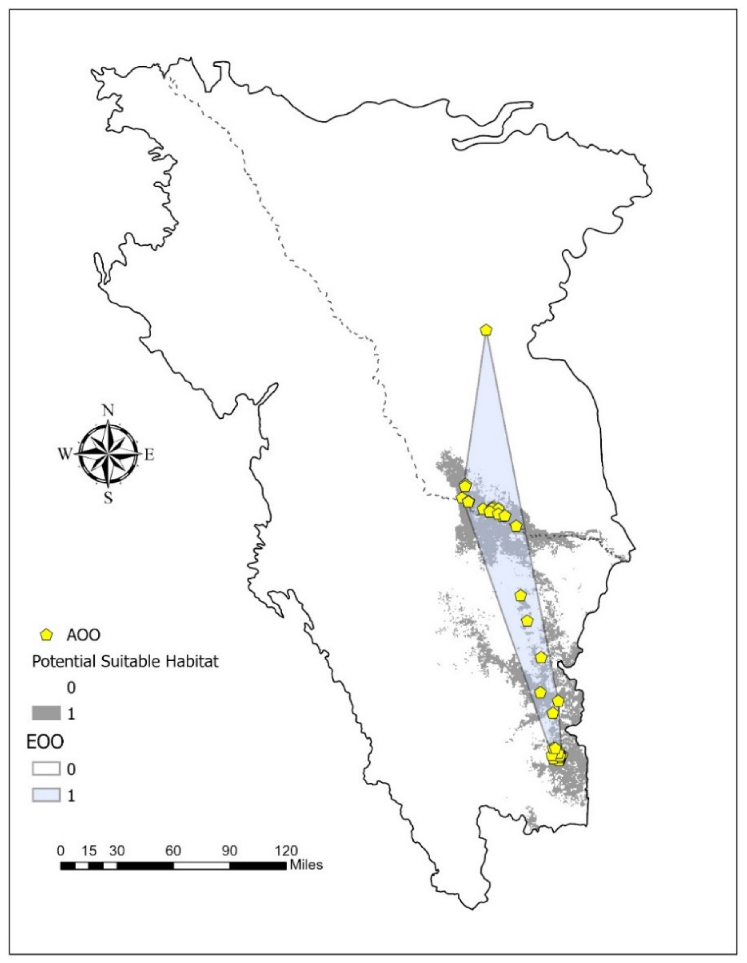
3.2. Result: IUCN Assessment Method
3.3. Result: Mexico’s Risk Assessment Method (MER)
4. Discussion
5. Conclusions
Author Contributions
Funding
Acknowledgments
Conflicts of Interest
References
- Maxted, N.; Kell, S.P. Establishment of a Global Network for the In-Situ Conservation of Crop Wild Relatives: Status and Needs; FAO Commission on Genetic Resources for Food and Agriculture: Rome, Italy, 2009; p. 266. [Google Scholar]
- Maxted, N.; Kell, S.; Ford-Lloyd, B.; Dulloo, E.; Toledo, Á. Toward the systematic conservation of global crop wild relative diversity. Crop Sci. 2012, 52, 774–785. [Google Scholar] [CrossRef]
- Heywood, V.; Casas, A.; Ford-Lloyd, B.; Kell, S.; Maxted, N. Conservation and sustainable use of crop wild relatives. Agric. Ecosyst. Environ. 2007, 121, 245–255. [Google Scholar] [CrossRef]
- Enquist, B.J.; Feng, X.; Boyle, B.; Maitner, B.; Newman, E.A.; Jørgensen, P.M.; Roehrdanz, P.R.; Thiers, B.M.; Burger, J.R.; Corlett, R.T.; et al. The commonness of rarity: Global and future distribution of rarity across land plants. Sci. Adv. 2019, 5, eaaz0414. [Google Scholar] [CrossRef] [PubMed] [Green Version]
- IUCN. IUCN Red List Categories and Criteria: Version 3.1, 2nd ed.; IUCN: Gland, Switzerland, 2012; pp. iv + 32. [Google Scholar]
- De Grammont, P.C.; Cuarón, A.D. An evaluation of threatened species categorization systems used on the American continent. Conserv. Biol. 2006, 20, 14–27. [Google Scholar] [CrossRef]
- Feria-Arroyo, T.P.; Olson, M.E.; Garcia-Mendoza, A.; Solano, E. A GIS-based comparison of the Mexican national and IUCN methods for determining extinction risk. Conserv. Biol. 2009, 23, 1156–1166. [Google Scholar] [CrossRef]
- Kaky, E.; Gilbert, F. Assessment of the extinction risks of medicinal plants in Egypt under climate change by integrating species distribution Agriculture models and IUCN Red List criteria. J. Arid Environ. 2019, 170, 103988. [Google Scholar] [CrossRef]
- Cassini, M.H. Ranking threats using species distribution models in the IUCN Red List assessment process. Biodivers. Conserv. 2011, 20, 3689–3692. [Google Scholar] [CrossRef]
- Syfert, M.M.; Joppa, L.; Smith, M.J.; Coomes, D.A.; Bachman, S.P.; Brummitt, N.A. Using species distribution models to inform IUCN Red List assessments. Biol. Conserv. 2014, 177, 174–184. [Google Scholar] [CrossRef]
- Keith, D.A.; Mahony, M.; Hines, H.; Elith, J.; Regan, T.J.; Baumgartner, J.B.; Hunter, D.; Heard, G.W.; Mitchell, N.J.; Parris, K.M.; et al. Detecting extinction risk from climate change by IUCN Red List criteria. Conserv. Biol. 2014, 28, 810–819. [Google Scholar] [CrossRef]
- Kusumoto, B.; Shiono, T.; Konoshima, M.; Yoshimoto, A.; Tanaka, T.; Kubota, Y. How well are biodiversity drivers reflected in protected areas? A representativeness assessment of the geohistorical gradients that shaped endemic flora in Japan. Ecol. Res. 2017, 32, 299–311. [Google Scholar] [CrossRef] [Green Version]
- Le Breton, T.D.; Zimmer, H.C.; Gallagher, R.V.; Cox, M.; Allen, S.; Auld, T.D. Using IUCN criteria to perform rapid assessments of at-risk taxa. Biodivers. Conserv. 2019, 28, 863–883. [Google Scholar] [CrossRef] [Green Version]
- Okigbo, B.N. Nutritional implications of projects giving high priority to the production of staples of low nutritive quality: The case for cassava (Manihot esculenta, Crantz) in the humid tropics of West Africa. Food Nutr. Bull. 1980, 2, 1–10. [Google Scholar] [CrossRef]
- Morante, N.; Sánchez, T.; Ceballos, H.; Calle, F.; Pérez, J.C.; Egesi, C.; Cuambe, C.E.; Escobar, A.F.; Ortiz, D.; Chávez, A.L.; et al. Tolerance to postharvest physiological deterioration in cassava roots. Crop Sci. 2010, 50, 1333–1338. [Google Scholar] [CrossRef]
- Simon, M.F.; Reis, T.S.; Arquelão, T.K.; Bringel, J.B.; Noronha, S.E.; Martins, M.L.; Ledo, C.A.; Silva, M.J.; Sampaio, A.B.; Matricardi, E.T.; et al. Conservation assessment of cassava wild relatives in central Brazil. Biodivers. Conserv. 2020, 29, 1589–1612. [Google Scholar] [CrossRef]
- Vera-Sánchez, K.S.; Nassar, N. Manihot Walkerae. The IUCN Red List of Threatened Species. 2019. Available online: https://www.iucnredlist.org/species/20755842/20756066 (accessed on 7 April 2020).
- SEMARNAT (Secretaría de Medio Ambiente y Recursos Naturales). Norma Oficial Mexicana NOM–059–ECOL–2001, Protección Ambiental—Especies Nativas de México de Flora y Fauna Silvestres—Categorías de Riesgo y Especificaciones Para su Inclusión, Exclusión o Cambio—Lista de Especies en Riesgo. Diario Oficial de la Federación (6 de Marzo de 2002), Primera Sección; Diario Oficial de la Federación: Mexico City, México, 2002.
- Garza, G.; Rivera, A.; Venegas Barrera, C.S.; Martinez-Ávalos, J.G.; Dale, J.; Feria Arroyo, T.P. Potential Effects of Climate Change on the Geographic Distribution of the Endangered Plant Species Manihot walkerae. Forests 2020, 11, 689. [Google Scholar] [CrossRef]
- Saravanan, R.A.; Ravi, V.; Stephen, R.; Thajudhin, S.H.; George, J. Post-harvest physiological deterioration of cassava (Manihot esculenta)—A review. Indian J. Agric. Sci. 2016, 86, 1383–1390. [Google Scholar]
- Zainuddin, I.M.; Fathoni, A.; Sudarmonowati, E.; Beeching, J.R.; Gruissem, W.; Vanderschuren, H. Cassava post-harvest physiological deterioration: From triggers to symptoms. Postharvest Biol. Technol. 2018, 142, 115–123. [Google Scholar] [CrossRef]
- Clayton, P.W. Walker’s Manioc Manihot Walkerae Recovery Plan; Region 2; U.S. Fish and Wildlife Service: Albuquerque, NM, USA, 1993.
- Best, C.; Miller, A.; Cobb, R. Walker’s Manioc (Manihot Walkerae) 5-Year Review: Summary and Evaluation; U.S. Fish and Wildlife Service: Albuquerque, NM, USA, 2009.
- Rodrigues, A.S.; Pilgrim, J.D.; Lamoreux, J.F.; Hoffmann, M.; Brooks, T.M. The value of the IUCN Red List for conservation. Trends Ecol. Evol. 2006, 21, 71–76. [Google Scholar] [CrossRef]
- Brown, J.L. SDM toolbox: A python-based GIS toolkit for landscape genetic, biogeographic and species distribution model analyses. Methods Ecol. Evol. 2014, 5, 694–700. [Google Scholar] [CrossRef]
- Phillips, S.J.; Anderson, R.P.; Dudík, M.; Schapire, R.E.; Blair, M.E. Opening the black box: An open-source release of Maxent. Ecography 2017, 40, 887–893. [Google Scholar] [CrossRef]
- Phillips, S.J.; Dudík, M.; Schapire, R.E. [Internet] Maxent Software for Modeling Species Niches and Distributions (Version 3.4.1). Available online: http://biodiversityinformatics.amnh.org/open_source/maxent/ (accessed on 16 September 2019).
- ESRI 2022. ArcGIS Pro 2.5.1; Environmental Systems Research Institute: Redlands, CA, USA, 2022. [Google Scholar]
- Fielding, A.H.; Bell, J.F. A review of methods for the assessment of prediction errors in conservation presence/absence models. Environ. Conserv. 1997, 24, 38–49. [Google Scholar] [CrossRef]
- Lobo, J.M.; Jiménez-Valverde, A.; Real, R. AUC: A misleading measure of the performance of predictive distribution models. Glob. Ecol. Biogeogr. 2008, 17, 145–151. [Google Scholar] [CrossRef]
- Walter, S.D. The partial area under the summary ROC curve. Stat. Med. 2005, 24, 2025–2040. [Google Scholar] [CrossRef]
- Peterson, A.T.; Papeş, M.; Soberón, J. Rethinking receiver operating characteristic analysis applications in ecological niche modeling. Ecol. Model. 2008, 213, 63–72. [Google Scholar] [CrossRef]
- Bachaman, S.; Moat, J.; Hill, A.W.; De La Torre, J.; Scott, B. Supporting red list threat assesments with GeoCAT: Geospatial conservation assesment tool. ZooKeys 2011, 150, 117–126. [Google Scholar] [CrossRef]
- Tambutti, M.; Aldama, A.; Sánchez, O.; Soberón, J. La determinación del riesgo de extinción de especies silvestres en México. Gac. Ecol. 2001, 61, 11–21. [Google Scholar]
- Sánchez, O. Método de Evaluación del Riesgo de Extinción de Las Especies Silvestres en México (MER); Instituto Nacional de Ecología: Mexico City, Mexico, 2007.
- Sanderson, E.W.; Jaiteh, M.; Levy, M.A.; Redford, K.H.; Wannebo, A.V.; Woolmer, G. The human footprint and the last of the wild: The human footprint is a global map of human influence on the land surface, which suggests that human beings are stewards of nature, whether we like it or not. BioScience 2002, 52, 891–904. [Google Scholar] [CrossRef]
- Li, Q.; Zhao, Y.; Xiang, X.; Chen, J.; Rong, J. Genetic Diversity of Crop Wild Relatives under Threat in Yangtze River Basin: Call for Enhanced In Situ Conservation and Utilization. Mol. Plant 2019, 12, 1535–1538. [Google Scholar] [CrossRef]
- Rito, K.F.; Tabarelli, M.; Leal, I.R. Euphorbiaceae responses to chronic anthropogenic disturbances in Caatinga vegetation: From species proliferation to biotic homogenization. Plant Ecol. 2017, 218, 749–759. [Google Scholar] [CrossRef]
- Essi, L.; Lima, M.D.F.R.C.; Leite, L.G.; Wolf, M.M. Threatened and understudied: The lack of genetic data of endangered Brazilian plant species. Cienc. Nat. 2020, 42, 28. [Google Scholar] [CrossRef]

| Environmental Variable Name | Type | % Contribution |
|---|---|---|
| Biomes | Categorical | 6.7 |
| Water basins | Categorical | 59.7 |
| Soil Type | Categorical | 9.4 |
| Percentage of water per km2 | Continuous | 0.1 |
| Canopy height | Continuous | 0 |
| Percentage of bushes per km2 | Continuous | 3.2 |
| Percentage of deciduous broadleaf trees per km2 | Continuous | 1.3 |
| Ecoregion | Continuous | 0.5 |
| Elevation | Continuous | 11 |
| Herbaceous percentage per km2 | Continuous | 0.2 |
| Humidity index | Continuous | 1.3 |
| Maximum temperature in the coldest four-month period (°C) | Continuous | 4.1 |
| Total annual precipitation | Continuous | 0.1 |
| Solar radiation for the month of June | Continuous | 0.3 |
| Critically Endangered | Endangered | Vulnerable | |
|---|---|---|---|
| Extent of Occurrence (EOO) | <100 km2 | <5000 km2 | <20,000 km2 |
| Area of Occupancy (AOO) | <10 km2 | <500 km2 | <2000 km2 |
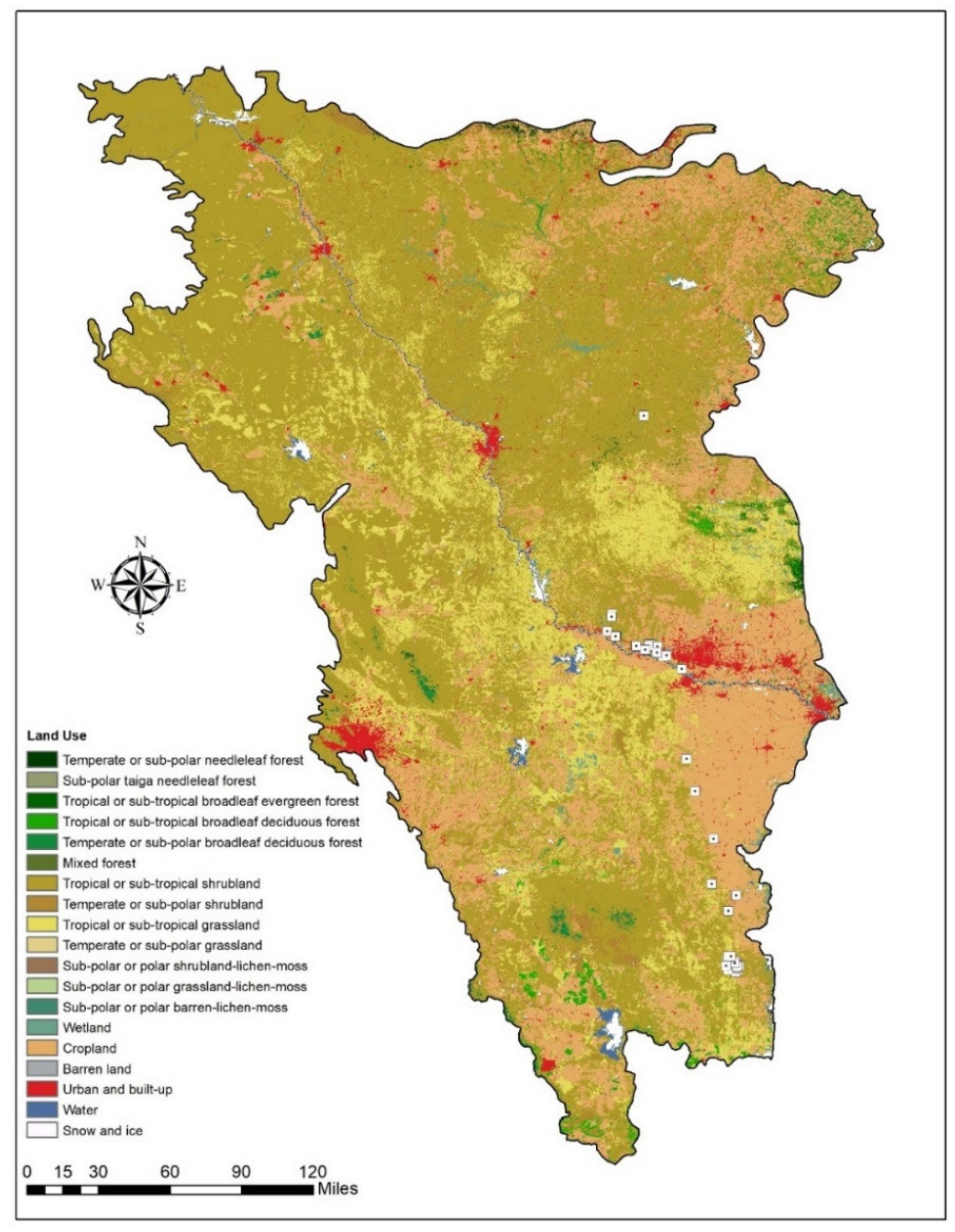
| Land Use Type | Area (ha) | % Area |
|---|---|---|
| Temperate or sub-polar needleleaf forest | 15,168 | 0.08 |
| Tropical or sub-tropical broadleaf evergreen forest | 39,389 | 0.21 |
| Tropical or sub-tropical broadleaf deciduous forest | 177,755 | 0.95 |
| Temperate or sub-polar broadleaf deciduous forest | 62,914 | 0.33 |
| Mixed forest | 57,111 | 0.30 |
| Tropical or sub-tropical shrubland | 10,400,941 | 55.31 |
| Temperate or sub-polar shrubland | 251,426 | 1.34 |
| Tropical or sub-tropical grassland | 2,824,264 | 15.02 |
| Temperate or sub-polar grassland | 107,256 | 0.57 |
| Wetland | 186,422 | 0.99 |
| Cropland | 3,906,422 | 20.77 |
| Barren land | 46,973 | 0.25 |
| Urban and built-up | 525,708 | 2.80 |
| Water | 203,952 | 1.08 |
| Criterion B | Values (km2) | Criterion B Category |
|---|---|---|
| EOO | 10,363 km2 | Vulnerable |
| AOO | 132.00 km2 | Endangered |
| Potential Geographic Distribution | 12,274 km2 | Vulnerable |
| Criterion A | Values (km2) | % of Mexico’s Area (1,964,375 km2) | Criterion A Category | Criterion A Value |
|---|---|---|---|---|
| EOO Mexico | 1223 km2 | 0.062% | Very restricted species | 4 |
| AOO Mexico | 76 km2 | 0.0038% | Very restricted species | 4 |
| Potential Geographic Distribution in Mexico | 9986 km2 | 0.51% | Very restricted species | 4 |
| Criterion | Human Footprint Value | Category Designation | Category Value |
|---|---|---|---|
| B | 24 | Slightly or not limiting | 1 |
| D | 24 | Low degree of human impact | 2 |
Publisher’s Note: MDPI stays neutral with regard to jurisdictional claims in published maps and institutional affiliations. |
© 2022 by the authors. Licensee MDPI, Basel, Switzerland. This article is an open access article distributed under the terms and conditions of the Creative Commons Attribution (CC BY) license (https://creativecommons.org/licenses/by/4.0/).
Share and Cite
Garza, G.; Venegas Barrera, C.S.; Dale, J.; Martínez-Ávalos, J.G.; Feria Arroyo, T.P. Towards Conserving Crop Wild Relatives along the Texas–Mexico Border: The Case of Manihot walkerae. Sustainability 2022, 14, 5392. https://doi.org/10.3390/su14095392
Garza G, Venegas Barrera CS, Dale J, Martínez-Ávalos JG, Feria Arroyo TP. Towards Conserving Crop Wild Relatives along the Texas–Mexico Border: The Case of Manihot walkerae. Sustainability. 2022; 14(9):5392. https://doi.org/10.3390/su14095392
Chicago/Turabian StyleGarza, Gisel, Crystian Sadiel Venegas Barrera, Jon Dale, José Guadalupe Martínez-Ávalos, and Teresa Patricia Feria Arroyo. 2022. "Towards Conserving Crop Wild Relatives along the Texas–Mexico Border: The Case of Manihot walkerae" Sustainability 14, no. 9: 5392. https://doi.org/10.3390/su14095392
APA StyleGarza, G., Venegas Barrera, C. S., Dale, J., Martínez-Ávalos, J. G., & Feria Arroyo, T. P. (2022). Towards Conserving Crop Wild Relatives along the Texas–Mexico Border: The Case of Manihot walkerae. Sustainability, 14(9), 5392. https://doi.org/10.3390/su14095392