Article

Land-Use Changes and Socioeconomic Conditions of Communities along the Carajás Railroad in Eastern Amazonia

by
Laís de Andrade Cristo
1,
Marco Aurélio Santos
2 and
Valente José Matlaba
3,*
1
Energy Planning Program, Federal University of Rio de Janeiro, Rio de Janeiro 21941-901, Brazil
2
Research Productivity Scholarship from CNPq—National Council of Science, and Energy Planning Program, Federal University of Rio de Janeiro, Rio de Janeiro 21941-901, Brazil
3
Instituto Tecnológico Vale, Belém 66055-090, Brazil
*
Author to whom correspondence should be addressed.
Sustainability 2022, 14(9), 5132; https://doi.org/10.3390/su14095132
Submission received: 24 March 2022 / Revised: 14 April 2022 / Accepted: 20 April 2022 / Published: 24 April 2022
(This article belongs to the Special Issue Sustainability in Mining)

Abstract

:
Studies on communities along railroads are relevant because of the impacts of operations on their socioeconomic and environmental conditions. The objective of this paper was to examine 32 communities affected by the Carajas railroad between 2010 and 2017. The socioeconomic and environmental dimensions involved an examination of 17 indicators and a qualitative analysis of Google Earth images, respectively. We applied appropriate statistical tests for data analysis. The results showed that urban communities have better socioeconomic conditions (higher incomes and less poverty) than rural ones; and that those in Maranhão are in a less sustainable situation (poor socioeconomic indicators and significant changes in land cover). The communities near the railroad showed higher variation in socio-environmental conditions. We conclude that socioeconomic and satellite images data analysis can help increase the resilience and sustainability of communities in risk situations. The latter include people with few financial resources, poor housing conditions, and living in areas with significant land cover changes because they provide fundamental data and information that can guide action through the formulation and execution of public policies or decision-making by other agents, such as private companies. Therefore, policymakers, managers, and other stakeholders should focus on community-scale deficiencies, especially in identified priority communities.

1. Introduction

The technical-scientific-informational environment—a term created by [1] and translated as the third and current phase of the Industrial Revolution—has increasingly altered the geographic space. This spatial change becomes even more evident when we focus on the Eastern Amazon region, where mining directly influences the demographic, economic, and environmental dynamics.
The mineral exploration in this region of the Brazilian Amazon by the Vale S.A involves a large mining and logistics complex, covering part of the Pará and Maranhão states. The mine-rail-port system, located between the mines of the Carajás site, including the S11D mine, in Canaã dos Carajás municipality, Pará, and the Ponta da Madeira Port, in São Luís, Maranhão, are interconnected by the approximately 1000 km of extension referring to the Carajás Railroad and its branch (named henceforward as EFC).
The territory of the EFC has been the scene of conflicts by resistance, for example, against the railroad expansion works, for better living conditions, more economic opportunities, and land regularization, which are issues that have been worsened due to the partial absence of active State power [2]. These impacts or negative externalities tend to shake the trust of local companies (in this case, the largest mining company) by the population concerning their actions and influence the social perception of their enterprises [3].
Despite the recent inductions of conflicts and resistance in the Amazon, it is fundamental to mention the importance of the economic development model implemented in the region, especially during its occupation process (the 1960s and 1970s). This development model, drawn and coordinated by the Federal Government, was characterized by the implementation of tax incentive policies, colonization projects, investments in economic activities, large projects, and infrastructure to integrate the region into the rest of the country, which decisively influenced the current configuration of the territory, which is still far from being sustainable [3,4,5,6,7].
Investigating the perception of nature’s contributions by rural communities, [3] pointed out that these communities, in general, are more affected by activities that generate environmental degradation, which demonstrates the need for study at the community level and, consequently, to overcome the lack of information and socioeconomic data at this scale.
At the same time, Santos et al. [8] stress the importance of analyzing changes in land use and land cover in the territory of the EFC, although they highlight that rail transport produces a lower impact on land use compared, for example, to pastures. In addition, the authors mention that the vast majority of studies on this topic focus on urban areas, drawing attention to the need and importance of thinking about land cover changes in the rural sphere, a gap that we seek to fill with our study.
Some studies seek to discuss urban dynamics through an analysis between land use and spatial correlation, such as [9,10]. Although focused on urban areas, we understand their results as relevant proposals to be adapted to regions like the EFC. Therefore, there is still a contribution to be made in the studies on this territory.
Despite the growing literature, there are still few studies involving the EFC territory. Previous studies have analyzed this territory as a whole, without focusing on communities, generally concerned with biological, physical, and environmental analyses [11,12,13,14]. In the socioeconomic scope, we can mention the works by [15] that present a proposal of sustainability indicators in mining. Measuring the Social License to Operate (LSO) of the mining industry in the municipality of Canaã dos Carajás, [6] found an average score of the LSO of 3.63 ± 0.87. The perception of resilience in Canaã dos Carajás was analyzed by [7], who concluded that it was reasonable, with an average score of 3.04 ± 0.22 (on a Likert scale with an Alpha of Cronbach 0.788).
Moreover, other studies worked on a community scale, focusing on the networks of institutions, and found a sparse network along with the EFC with few links and a low capacity for collective articulation [2]. The perception of nature’s contributions to people (NCP) in five rural communities in the Eastern Amazon has been analyzed [3]. The latter study concluded that, on a Likert scale, the interviewees ranked the NCP categories high (roughly 67%, 75%, and 80% of respondents for material, non-material, and regulating NCP, respectively).
The main objective of this study is to examine, in communities directly influenced by the EFC, the socio-economic and environmental conditions. Land use and the indicators changes in these dimensions on a 32-community sample for the 2010–2017 period are analyzed. This paper used social and economic indicators and qualitatively analyzed the satellite images. Since these communities are directly (or indirectly) influenced by this relevant logistical infrastructure, they are critical within the EFC and the Great Carajás Project. The research has done primary and secondary data quantitative analysis and highlighted the demographic dynamics of these communities.
New studies focusing on communities located alongside large railway structures (as is the EFC) are needed, showing the relevance of this work in the subject. The railroad influences the communities more than the municipalities themselves or their headquarters since it directly crosses many communities or is very close to them [2,3,8,16].

1.1. Motivation

This study fills a relevant gap in the EFC literature. Its novelty is focusing on the detailed scale of communities (rural and urban) and jointly analyzing the evolution of their socioeconomic status with satellite images to understand land use and occupation changes. Besides, the analysis covers almost a decade, ensuring an inter-census analysis since it also used fieldwork data that overcome the absence of data between decadal censuses. In the international literature, this study adds theoretical knowledge since it confirms the relationships between land-use changes and socioeconomic conditions for communities, as pointed out by some studies. Moreover, practical knowledge due to a unique dataset of communities directly affected by large-scale infrastructure in a context where the environmental issue is fundamental.
Despite the growing number of studies concerning the Amazon region, few focus on the EFC territory. For instance, a methodological proposal for geological-geotechnical risk analysis was presented by [11]. The archeology area in the region was studied by [12], who highlighted the museums’ importance for the findings in the archeological research carried out in the territory. The reuse of discarded wood waste for electricity generation was analyzed by [13], who concluded that this process is environmentally sustainable. The optimization of the operational cycle of railway transportation was studied by [14], who developed three projects capable of generating gains for the EFC’s wagon cycle operation. The contradictory relations between development projects and contemporary slave labor in the railroad territory were analyzed by [17], who focused their studies on the State of Maranhão and concluded that the railroad could be related to impoverishment and making the region’s labor precarious.
Our research differs from others since it analyzes communities that, in general, are not studied in a specific way, and it bases such a study on the analysis of satellite images of the EFC territory linked to the analysis of data at the scale of census tracts. Besides, it works with primary data from field research. This approach assesses the socio-environmental conditions of the EFC communities over a period of almost a decade, which makes up for the absence of data after the last 2010 census and complements other studies on the railroad [12,13,14], focused on larger scales.
The EFC infrastructure transports 120 million tons of cargo—in 2016, it reached 155 million [18]—and 350 thousand passengers per year [19]. EFC’s region of influence has 2.4 million inhabitants and was responsible for about $17 billion in GDP in 2016 [5]. Except for São Luís, Marabá, Parauapebas, and Canaã dos Carajás municipalities, which are home to large companies, the territory has precarious socioeconomic indicators and suffers high environmental pressures. For instance, in 2016, the average GDP per capita was $3152 compared to $8756 in Brazil, and the average deforestation rate was 67%, against 21%, 40%, and 15% of Pará and Maranhão states, and the Brazilian Legal Amazon, respectively [5,20,21].
Therefore, to understand the living conditions of the populations living throughout the EFC, this research seeks to answer the following questions:
  • Do these data reflect on the lives of the residents of the communities located in this territory?
  • What are the land use and occupation conditions and their evolution in these communities from 2010 to 2017?
  • Does this evolution reflect the social and economic indicators of the 2010 census and field research for the biennium 2016–2017?
  • Do urban communities have better conditions than rural ones?
The economic, social, and environmental importance of the Carajás Railroad and its branch, a corridor for the flow of mining production and circulation of people, justifies the need for research and studies on the dynamics of municipalities and communities of its territory.
This research tests the following hypotheses:
  • The location of communities along the railroad is associated with types of land use and occupation in the territory;
  • Such a location directly influences the living conditions of locals;
  • The living conditions of the communities are the effect of the historical formation process of the municipalities of the Amazon region.
This work allows the identification and understanding of why several communities have better conditions than others or whether the railroad influences them more. Consequently, it will help establish targets for receiving the region’s actions and public or private policies.

1.2. Theoretical Foundations

The geographic space where the EFC is located has been reconfigured over the years by mineral exploration. The economic activities developed in the most diverse regions, including the Amazon region, are engendered by social, economic, and environmental factors. Thus, it is fundamental to analyze the relationship between these factors since they directly influence the reconfiguration of spaces [3,5,6,8].
The space is also reconfigured by land use and occupation changes. Their joint study with the socio-economic and environmental indicators analysis in a complex region, characterized by, for example, high biodiversity and many social actors operating in a region like the Amazon become even more challenging when dealing with a scale as specific as that of communities [8,22,23]. The absence of data on areas in detail makes it even harder to develop studies at this level.
The extraction of mineral resources is associated with many challenges, especially when they involve the health and well-being of workers and residents of locations close to mining enterprises [11]. Understanding the land-use and land cover changes is fundamental to analyzing the influence of activities on nearby communities.
The range of studies on land use and occupation is rich and has diversified with geographical technologies development. The regional economic impact of deforestation control policies in the Legal Amazon was studied by [22], who analyzed land-use dynamics, and pointed out that the regions with the highest GDP growth would be those on the deforestation frontier. An interpretation methodology for a quantitative assessment of land use and land cover changes in the Itacaiúnas River basin, southeast Amazon, from 1984 to 2017, was presented by [24], who found that 47% of the forest was preserved, while almost 42% of the area was converted to pasture. More recently, a relevant study about the intensity of land use of mineral extraction in the Amazon region through economic and spatial data was conducted by [23]. They showed that mining activity occupied 1110 km² with 47% of this total—mainly artisanal gold extraction—within protected areas, while industrial iron mining had the lowest impacts and highest incomes (91.8 million dollars/km2).
In the international literature, several studies analyze socioeconomic data with land use. For instance, a European project to model inter-regional migration flows was examined by [25]; the latter was subsequently related to land cover and land use in Europe. An evaluation of land use and land cover changes over 12 years in a Canadian province was made by [26], relating social, economic, and demographic data with environmental data.
These studies show the importance of the relationship of land use and occupation analysis with socioeconomic, demographic, and environmental data on the Amazon region, more specifically the EFC territory, which historically presents precarious socioeconomic indicators—except in municipalities that concentrate mines and high infrastructure—together with various environmental pressures in the region [27]. In this paper, following the Ministry of Science and Technology, we classified land-use change as forest conversion in areas for other purposes such as pasture, agriculture, or other land-use forms [28].
Analysis of demographic data, population growth, and migratory flows can also be important allies in studies that examine land use and occupation. Data on migration and land use in Europe were reviewed by [29]. An evaluation of the effect of demographic, environmental, and socioeconomic variables on the land cover change between 2001 and 2010 for Mexican municipalities and biomes using secondary data was made by [30]. How transnational labor migration was affecting agricultural practices and land use in two-grain producing communities in Bolivia using mixed data was analyzed by [31].
There is a complicated connection (which analysis must be deepened by scholars) between migratory movements and land-use changes [29]. The latter responds to the pressures arising from migration that occurs in different ways and places. Some municipalities in the EFC’s influence area had already received intense migratory movements since its implementation [27], clarifying its importance since the beginning of this region’s occupation. These movements influence directly on land cover change in the railroad’s territory. When it is simultaneously observed that there is an evolution of socioeconomic data, for instance, from 1991 to 2000 [20], this becomes clearer.
The authors argue that researchers should define social sustainability in these communities by considering the often unique circumstances they have in common, such as the need to deal with the changes associated with dams and mining recessions [11]. Simultaneously, Cross et al. [32] argue that people in rural communities or small towns are more vulnerable than in large cities and urban areas due to the lack of preparation for risk situations. In this study, the changes occurred in mining activity and the railway structure (implementation and recent duplication) [33].
The 2002 International Mining, Minerals, and Sustainable Development (MMSD) report is a relevant reference for mining companies in their relationship with communities near mining enterprises, performing research and consultation, examines the relationships between the world’s mineral system and the sustainable development objectives. The project ended in mid-2002 and resulted in a Breaking New Ground report [34].
Two MMSD chapters deal specifically with the Control, Use, and Management of Lands and Local Communities and Mines, demonstrating the importance of assessing the influence of land use and land cover on the treatment of issues involving mining companies and communities, always seeking to make mineral production and exploration meet human needs in the most sustainable way possible.
The Amazon has historically been the target of actions aimed at its integration and pursuit of development, translated into the construction of large infrastructures and projects, which generally do not contemplate the social and environmental dimensions equivalent to the economic [35]. These authors emphasize that the land use and coverage distribution reflects the region’s policies that have historically been implemented.
Despite being an undeniable result of mining and other activities development, scholars have linked the changes in land use identified in the studied territory to the historical development and occupation of the Amazon region. Researchers should consider this background in socioeconomic indicators with demographic and environmental data analysis, seeking risk reduction and building resilience in these locations. Risk reduction and resilience building are clear effects of establishing social justice and maintaining ecological integrity, and the latter two concepts are directly related to sustainability [36]. Simultaneously, they are priority features among the Sustainable Development Goals (SDGs) established by the UN to achieve by 2030 [37].

2. Materials and Methods

2.1. Study Area

The EFC territory crosses 28 municipalities, 5 and 23 in Pará and Maranhão states, respectively, in addition to hundreds of rural and urban communities located along this route (Figure 1), with a total population of about 2.2 (or 15% of states’) in 2010 and 2.5 million (or 16% of states´) inhabitants in 2020. From 2010 to 2020, the population growth rate in the territory was about 1%, compared to 1.4%, 0.8%, and 1% for the reference regions of Pará, Maranhão, and Brazil, respectively [38]. The Carajás railroad, inaugurated in 1985 and, with its branch, is currently approximately 1000 km long, connecting the S11D mine in Canaã dos Carajás municipality, in Pará state, to the Ponta da Madeira port in São Luís city, Maranhão state [19].
Parauapebas, Marabá, Açailândia, and São Luís municipalities had the highest population density within this territory. In 2020, according to a population estimate by the Brazilian Institute of Geography and Statistics (named henceforward as IBGE), these municipalities concentrated on roughly 1.7 million inhabitants. Even though they are not among the most populous (38,103 inhabitants), Canaã dos Carajás stand out as home to the mining Project S11D, known as the world’s largest iron ore extraction Project (and in the company’s history). This Project is in block D of the geological body S11, in the Serra Sul subdivision of Serra dos Carajás, southeastern Pará [19].
Until the duplication occurred in 2017, the EFC transported 120 million tons of cargo and 350,000 passengers per year through 35 trainsets simultaneously, with 330 wagons and 3.3 km long. From the duplication of the 575 km of the EFC in Pará and Maranhão, the railroad’s transport capacity increased to 230 million tons of iron ore per year [33].
In December 2020, the company and the National Agency for Land Transportation (ANTT) [18] signed an Amendment to the EFC Concession Contract, extending it for another 30 years and anticipating investments that would only be done by 2027. Among the benefits of the new contract are the mandatory investments in safety and capacity increase. The concession contract ends in June 2027 [18].
Since it analyzes the socio-economic conditions related to land-use changes in the communities, the theoretical structure of this study was based on the several studies exposed here and mainly on the tripod of sustainability, which considers the social, economic, and environmental dimensions addressed. Together, these dimensions clarify the importance of understanding the context of these communities; that is, whether their location influences land-use changes and whether the latter is related to their social and economic conditions.

2.2. Data and Procedures

In this paper, we studied the living conditions of rural and urban communities of the EFC through an analysis of 17 social and economic indicators, totalizing 63 collected variables. The environmental dimension was considered by examining land use and occupation from the qualitative analysis of satellite images obtained from Google Earth for 2010 and 2017. The study confirmed whether the socioeconomic indicators (local living conditions) result from land use and occupation patterns.
The data available on the scale of census tracts and the field research in the 2016–2017 biennium conditioned the analysis. The census tract scale presents a limitation because the IBGE changes its geographical definition across censuses. Consequently, a comparison between tracts of different censuses is difficult. Therefore, we choose the 2010 census, the most current delimitation of these polygons that are fundamental for the community-level analysis.
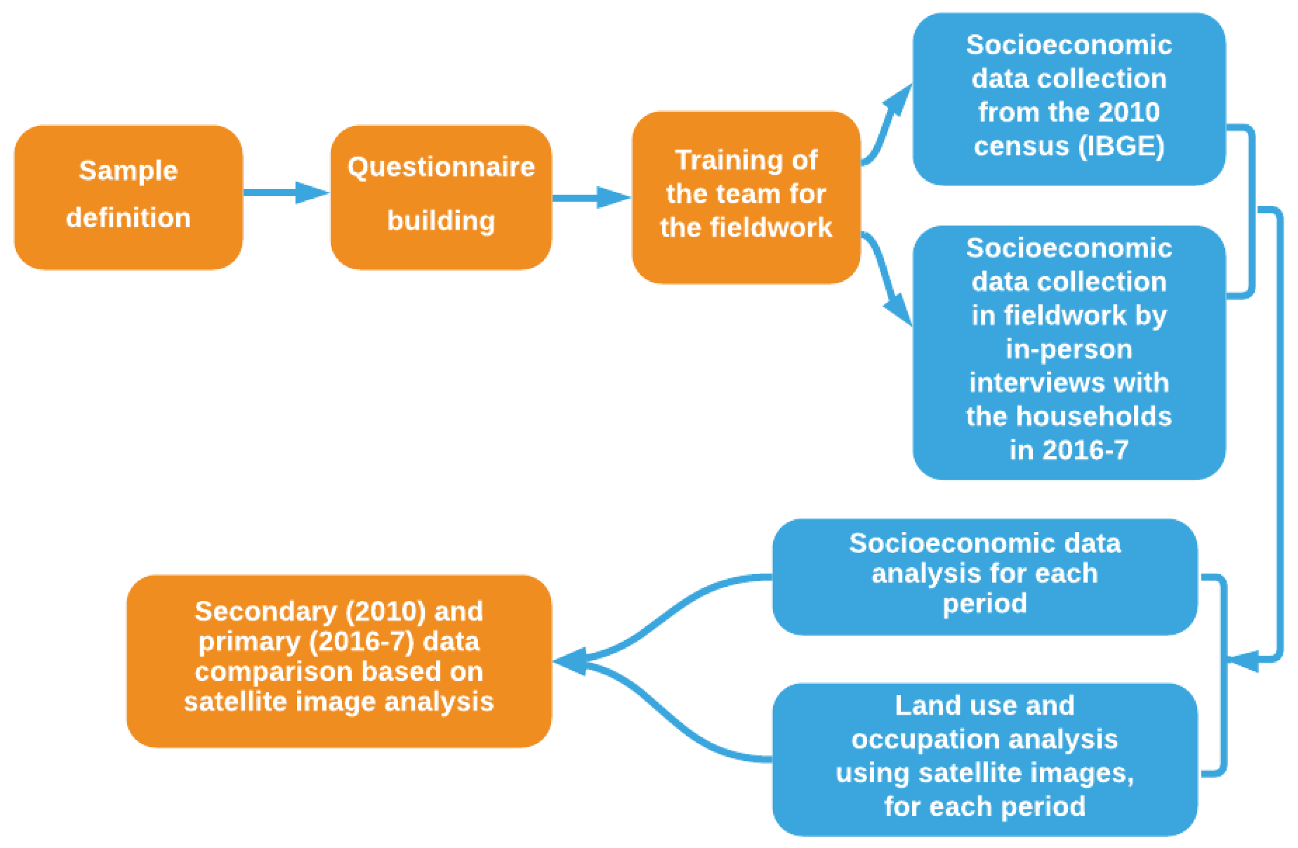
The approach involved social and economic data collection and statistical tests for their significance analysis using Stata 13.1 software. Subsequently, we have done the Google Earth satellite image visual analysis between the 2010–2011 and 2017 periods and a data evolution comparison based on image analysis. We analyzed images from 2011 when those from 2010 were not available or were not adequately visible. This study presents an experiment that compares secondary data from 32 communities from the 2010 census [20] and primary data collected using a questionnaire during field research in the EFC in the biennium 2016–2017. Socioeconomic indicators complement the analysis of land-use and land cover changes based on satellite images to verify the relationship between the data collected and the estimates based on the image analysis (Figure 2).
The fieldwork, done by 16 researchers from the Vale Institute of Technology, surveyed 1906 households (Table 1) in 2016 and 2017. This sample was selected using quotas, each referring to each researched community, based on population estimates (the overall households were about 37,682, with an average of 4 people per household). In each community, we defined the sample with a 95% confidence level and a 3.5% margin of error, with the latter being higher than 5% [39,40,41], often used in many surveys to ensure the high reliability of the research results.
Before the fieldwork, there was training for the research team to put all members on the same ground regarding the questionnaire and the interview’s approach. The households researched were randomly selected during the fieldwork; the research team was strategically and equally distributed in the communities to cover the entire area. The research team skipped the houses found empty and moved to the next ones. To do the interview, we approached, in their homes, adults aged 18 years or older and with enough knowledge to answer all the questions in the questionnaire, which concerned the socioeconomic issues of the household. To respect the ethical standards of research of the Vale Institute of Technology [42], the anonymity of interviewees was ensured. The interviews were conducted every day from 2–19 August 2016, 3–12 May 2017, and 18–30 May 2017 during working hours. The data were prepared in an Excel spreadsheet and were analyzed statistically in the Stata software [40].
We reduced the 49 communities to 32 due to discrepancies between the 2010 and 2016/2017 data. The reasons for the reduction in the communities were twofold: the limitations in the collection of censuses data (the variation of the polygons across censuses) so that we choose the most recent census (2010); secondly, the availability of census data, since the variables we collected in the fieldwork differed from those collected by the IBGE at the municipal level.
Several households or populations were smaller or much higher than those identified during the sample definition for the fieldwork. This problem occurred because of data limitation at the census tract level, where polygons previously defined frequently covered areas higher than the communities. These situations were confirmed from the image analysis and visual count of the number of homes in the communities’ images, identifying the inconsistency that justified their exclusion from this analysis.
The data amount differs between the 2010 census and the fieldwork. In the latter, we designed the applied questionnaire to analyze the communities living conditions concerning the EFC influence. Thus, the primary data are larger because they cover specific interests. Table S1 presents the variables collected, their definitions, treatment according to the 2010 census, and the questionnaire applied during the field research at the EFC.
In all variables, we performed the Kolmogorov–Smirnov normality test to identify whether the data followed a normal distribution. If positive, in the second step, we applied the parametric Student’s t-test to each variable; otherwise, we used the nonparametric Mann–Whitney and Kruskal–Wallis tests. This procedure is appropriate and recommended by the literature in data analysis [40,43,44,45,46]. We identified the variables that presented different averages between urban and rural communities each year, and we analyzed the difference in their variation between the years at the 5% significance level. The robustness of the results was checked by examining pairwise correlations among the variables in the study, from which we excluded one variable in each statistically significant Pearson correlation pair.
During the statistical tests, due to the lack of data for some communities, the number of observations varied: the water supply, sanitation, and electricity variables had 22, and all others had 30. Concerning the environmental dimension of this study, we prepared land-use and land cover maps of the EFC for 2010 and 2017 using the platform tools of the Annual Mapping of Land Cover and Land Use in Brazil (MapBiomas) project [47], and we have done visual analysis to compare the changes in land use and occupation.
Because the railroad scale does not allow for a more detailed analysis at the community level, we split the land cover maps for each of the states of Pará and Maranhão for 2010 and 2017. To analyze land cover changes in detail, we examined a temporal sequence of images in the 32 communities from their locations, considering the community’s surroundings, the number, and location of houses, the existence of vegetation, the infrastructure related to the railroad, the water bodies, and the roads.

3. Results

3.1. Demographic Analysis

Socioeconomic data of the 32 communities studied show they had different conditions. This situation can be justified by their location concerning the railroad and urban centers, resulting in greater socioeconomic and environmental pressures. Another justification is the communities’ status since we hypothesize that the urban is more developed and dynamic than the rural. This directly influences communities’ vulnerability and resilience, placing them in different socioeconomic statuses. Since the Agroplanalto Settlement and Tropical I, Tropical II, and Nova Ipiranga communities’ birth was after 2010, they were considered in the environmental dimension only.
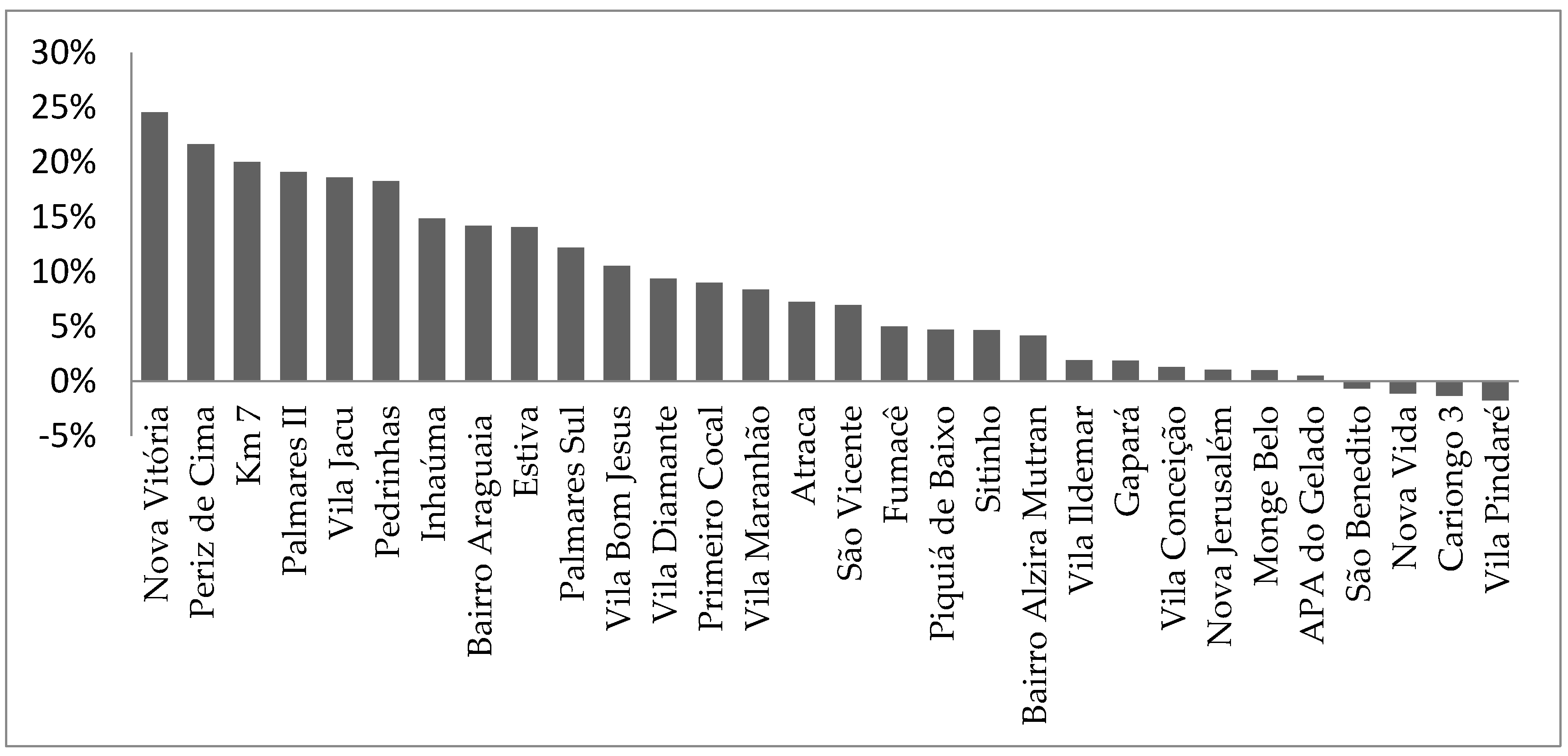
Overall, between 2010 and 2017, the population increased across communities. Nova Vitória, located in Parauapebas, Pará; Periz de Cima, in Bacabeira, Maranhão; and Km 7, in Marabá municipality, Pará, had the highest growth rates, 25%, 22%, and 20%, respectively. Vila Pindaré (−2%), Cariongo 3, Nova Vida, and São Benedito (each with a rate of −1%) were the only ones with a low reduction in population (Figure 3). These rates were inconsistent with the verified in the reference regions of Pará, Maranhão, and Brazil (approximately 1% each).
In 2010 and 2017, the communities with the largest population were urban, and all communities with falling population growth rates were rural. However, among the three most growing, only one was urban. In 2010, based on the Kolmogorov–Smirnov test, we identified that the 13 demographic and socioeconomic variables did not present a normal distribution (Table 2). Of these variables, seven were excluded from the analysis because they had a statistically significant correlation with at least one other on our findings. From the Mann–Whitney and Kruskal–Wallis nonparametric tests, we verified the differences in the means of these variables between urban and rural communities in 2010 (Table 2).
We confirmed statistically significant differences at a 5% level in the six variables in 2010 (Table 2). Concerning demographics, the number of households in urban communities was higher than in rural ones.

3.2. Socioeconomic Analysis

Regarding this dimension’s variables, total income in urban communities was higher than in rural ones, occurring the opposite of the poverty variable, as expected. Vila Ildemar ($2.5 million) in Açailândia municipality, Maranhão; Km 7 (approximately $1 million) in Marabá, Pará; and Pedrinhas (roughly $0.8 million) in São Luís, Maranhão, had the highest total household incomes and were the most populous communities. São Benedito, Atraca, and Nova Vida—all in Maranhão—had 32%, 30%, and 27% of their households in poverty, respectively. In contrast, the communities of Maranhão Atraca, in Tufilândia, Cariongo 3, in Miranda do Norte, and São Benedito, in Igarapé do Meio, presented the lowest total incomes, $13,297, $41,046, and $36,349, respectively, with the last two communities among the three lowest populations.
The percentages of literate people, economically active population occupied, and radios were higher in urban communities. Vila Conceição (25%), Km 7 (25%), and Fumacê (24%) presented the highest percentages of literate people responsible for the household, and Cariongo 3 (4%), APA do Gelado (12%), Nova Vitória (12%), and São Benedito (12%) were the worst communities in this variable.
In 2017, only two variables (out of five) that had statistically significant results followed a normal distribution, namely children and youth, and households with sewage; the Student’s t-test confirmed that the latter variable was higher in rural than in urban communities, and the opposite in the former. In the remaining three variables, we rejected the normality hypothesis. The Mann–Whitney and Kruskal–Wallis non-parametric tests showed that concerning durable goods, the number of cell phones in urban areas was higher than in rural communities, occurring the opposite for the motorcycles. Total income in urban was again higher than in rural communities (Table 3).
Vila Ildemar, Açailândia, in Maranhão, remained with the highest total income among the 32 communities ($233,673), followed by Palmares II ($80,347), in Parauapebas, and Km 7 ($70,674), in Marabá, both in Pará. The location of these communities is in economically relevant municipalities of the EFC. Açailândia municipality has the fourth-largest GDP in Maranhão state; Parauapebas and Marabá have the second and third largest GDP in Pará [38] and are relevant municipalities in the State’s Southeast region, where companies develop industrial mining.
Cariongo 3 ($1324) and São Benedito ($1391), again, had the lowest total incomes and were among the five communities with the lowest population in 2017. Bairro Araguaia ($171), in Marabá, and Vila Conceição ($157) and Gapará ($143), both in São Luís, had the highest per capita household incomes. Regarding the percentage variation between 2010 and 2017, eight of the variables studied had statistically significant results (Table 4); only the people born in the Federation Unit (FU) variable presented normal distribution with the Student’s t-test confirming the highest percentage variation in urban communities in the analyzed period.

3.3. Synthesis of the Analysis

During the 2010–2017 period, 15 communities reduced the number of household heads born in the Federation Unit where they are located. Nova Jerusalém and APA do Gelado, both in Pará, in Canaã dos Carajás and Parauapebas municipalities that concentrated the key mines of the territory presented the highest reduction in this variable, which indicates an increase in migration flows towards these locations.
The communities of Pará, especially Parauapebas, Canaã dos Carajás and Marabá, were the ones that had most residents from other states; these municipalities are a reference in the socioeconomic context of the EFC territory and the economic factors were fundamental for movements to these communities [5], of which only three of them were urban (out of nine located in these three municipalities).
For the other seven variables, we conducted non-parametric tests. As a consequence of the percentage variations in the data of these variables from 2010 to 2017, the variation in literacy and households with sewage was higher in rural than in urban communities, the opposite occurring for poverty. Concerning durable goods, the percentage variation in the refrigerators, cell phones, motorcycles, and television variables in rural communities was higher.
APA do Gelado, in Parauapebas, Pará, and Nova Vida, in Bom Jesus das Selvas, Maranhão, showed a 100% fall in households in poverty. Nova Vida stood out as one of the three communities with the highest poverty in 2010, despite showing a significant improvement in almost a decade. From the data analysis, it was also clear that there was an increase in literacy. Cariongo 3 community increased more than 15 times its literacy, followed by São Benedito and Nova Vitória, which increased this indicator by more than eight times.

3.4. Environmental Dimension

The land cover data in the EFC over the 2010–2017 period was as follows: in Pará State municipalities, about 53% and 45% (out of nearly 3 million hectares) of the area was forest and pasture, respectively. The other five land uses accounted for up to 2% in total; in Maranhão, roughly 54% and 42% (out of the area of about 3.5 million hectares) of the area were, contrary to Pará, pasture, and forest, respectively, with the other five land uses (two omitted here), together, responsible for approximately 5% [47].
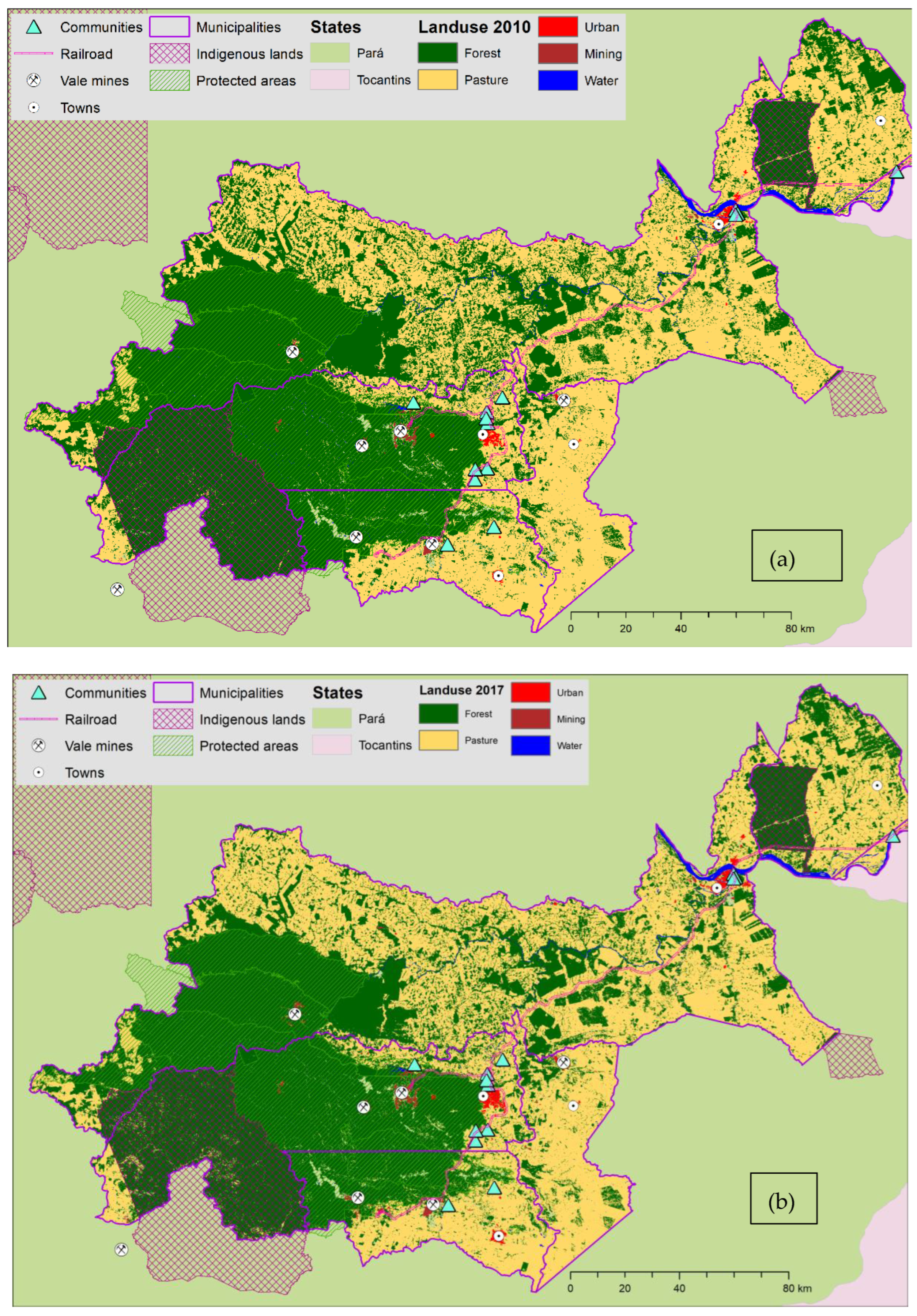
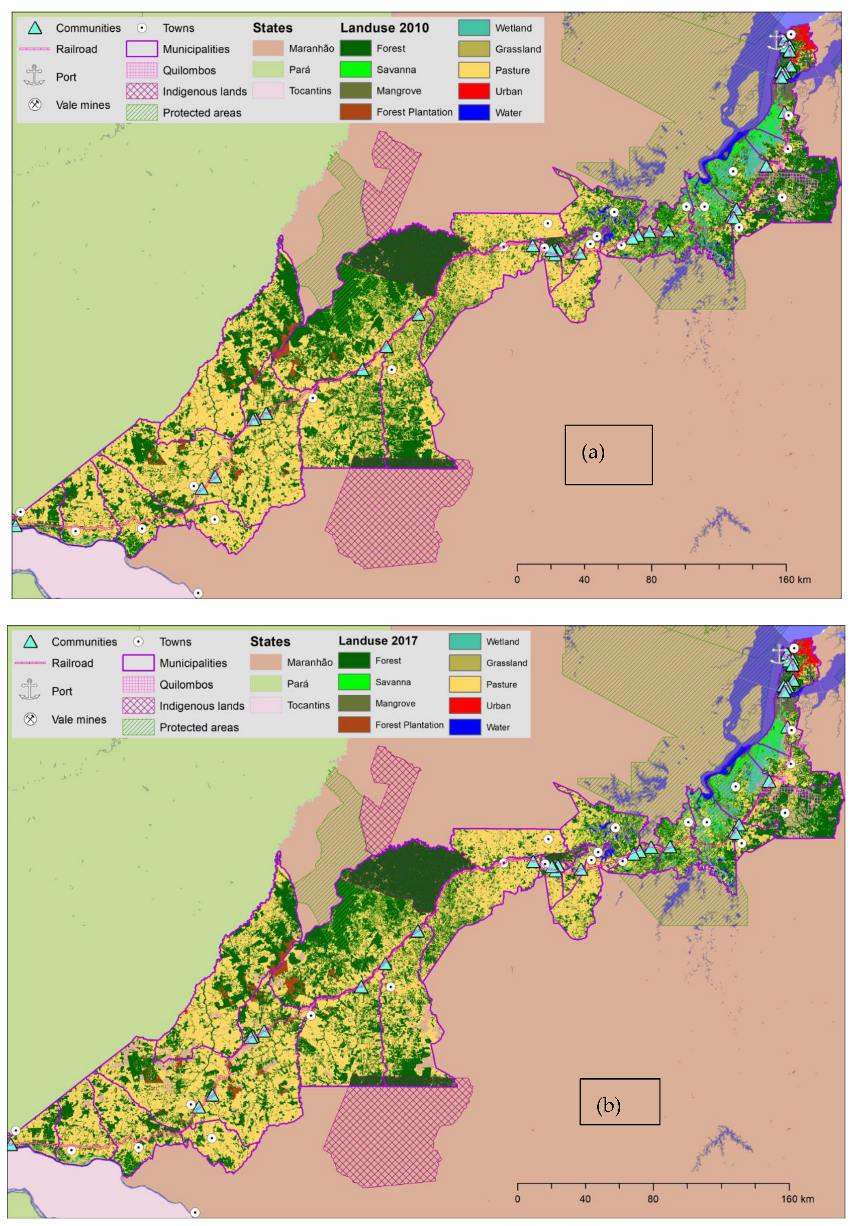
Consequently, the land cover maps on the railroad between 2010 and 2017 do not change significantly, considering that the municipalities of the Carajás railroad had large deforested areas already in 2010 (approximately 41,000 km²). As we can see in the maps, in both 2010 and 2017, most of the territory of the EFC was represented by pasture areas, except for indigenous lands, protected areas, and some remaining fragmented forests. The maps clarify the predominance of pasture in the territory, followed by forest areas, to the detriment of the other land cover classes presented (Figure 4a,b; Figure 5a,b). Due to a lack of information on land cover and land use at the community scale, we complemented the EFC maps with the satellite images at a detailed scale. These latter images enabled us the land cover changes visualization in all communities, as analyzed below.
This paper’s findings differ among the communities. The Agroplanalto Settlement, Tropical I, Tropical II and Nova Ipiranga, and Nova Vitória communities—the first in Açailândia, Maranhão, and the last two in Parauapebas, Pará—had the most relevant change in land use and coverage from 2010 to 2017. The birth of the first two communities was during this period, generating a significant alteration in these areas. The images of six (out of 32) communities analyzed below are illustrative examples due to the limited space, and the remaining ones are available upon request.
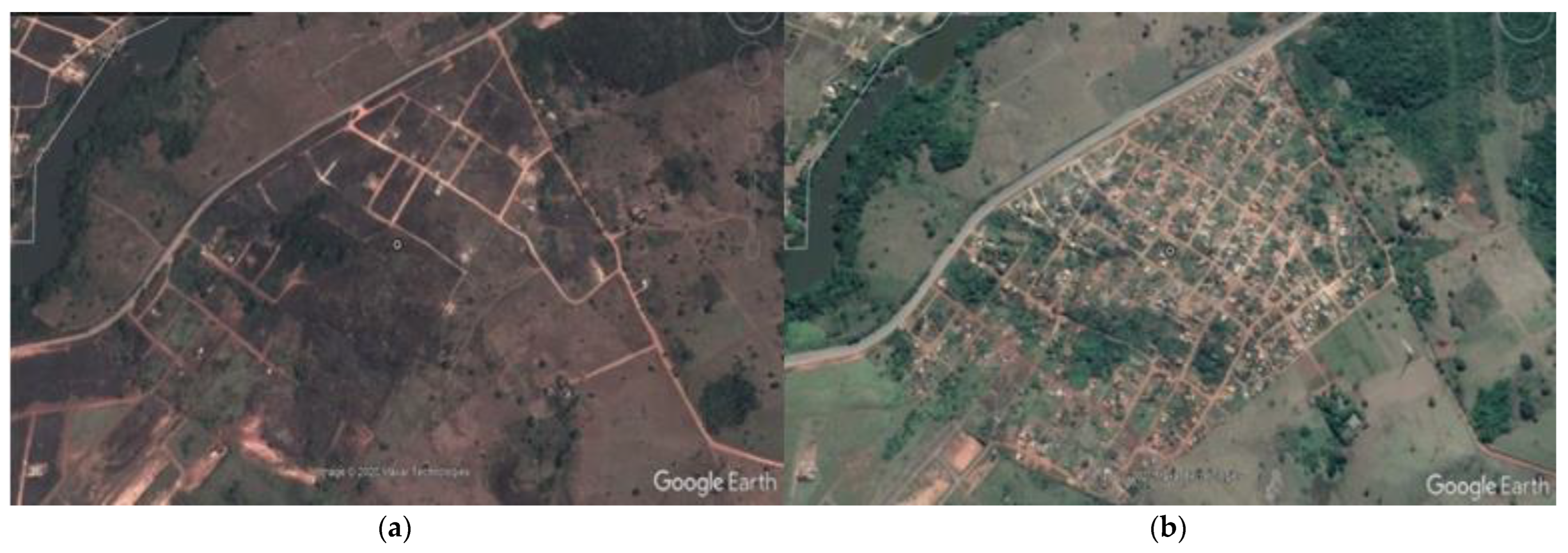
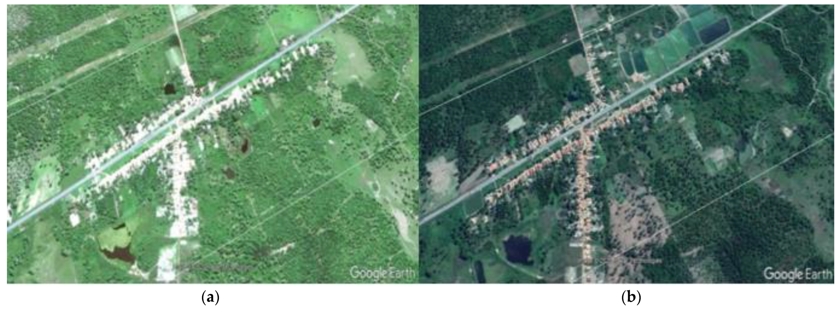
In the 2011 image of the Tropical I, II, and Nova Ipiranga communities (Figure 6a), we can only see a large area of pasture/vegetation with some points in the surrounding areas focused on industrial activities. In 2017, the households occupied all pasture areas (Figure 6b) and a community expansion of 100%, and we can identify the Southeast Pará railway branch on its east.
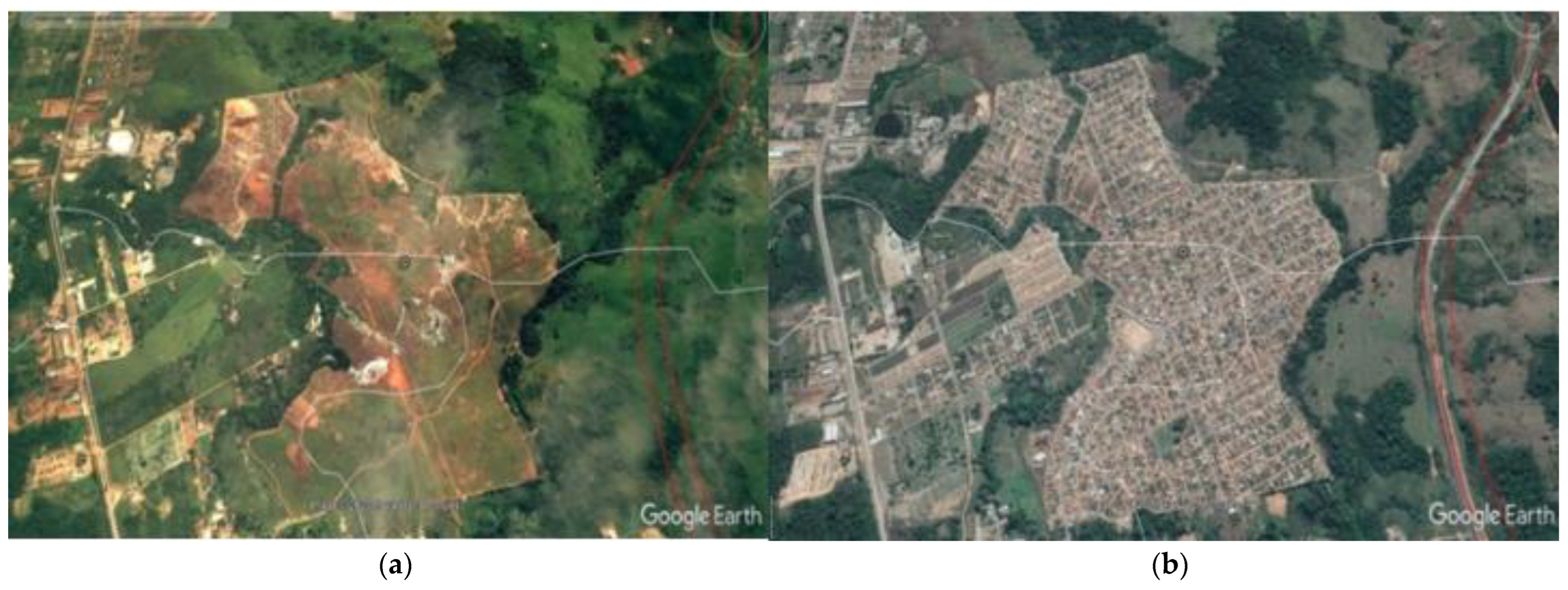
Nova Vitória, Tropical I, II, and Nova Ipiranga are located between the Southeast Pará railroad branch and the EFC. The expansion of the former and the creation of the latter are related to the railway extension, which occurred in parallel, connecting the mine in Canaã dos Carajás to the EFC, in Parauapebas. The expansion and significant change in land cover in the areas of these communities, including the suppression of vegetation and the increase in human occupation, are consistent with the changes in their socioeconomic and demographic data. Nova Vitória, for example, had the highest population growth rate in the studied period, proven by the 2010 and 2017 images (Figure 7a,b).
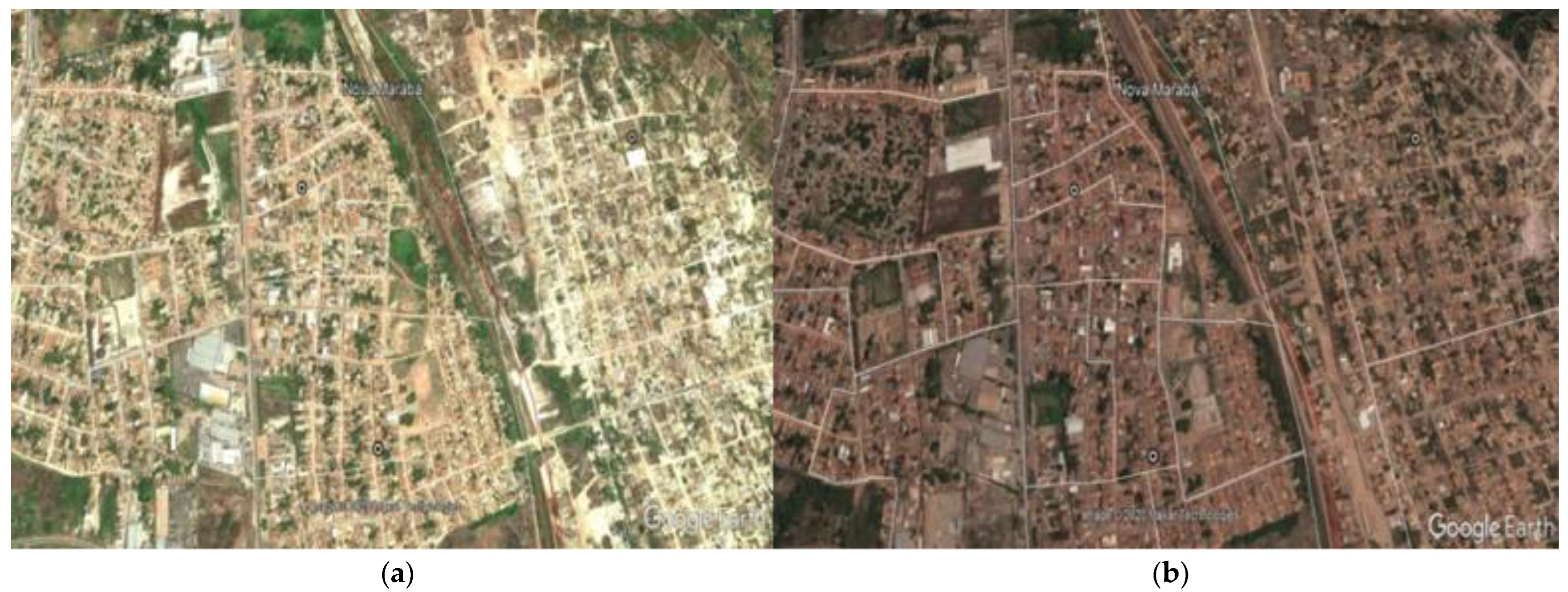
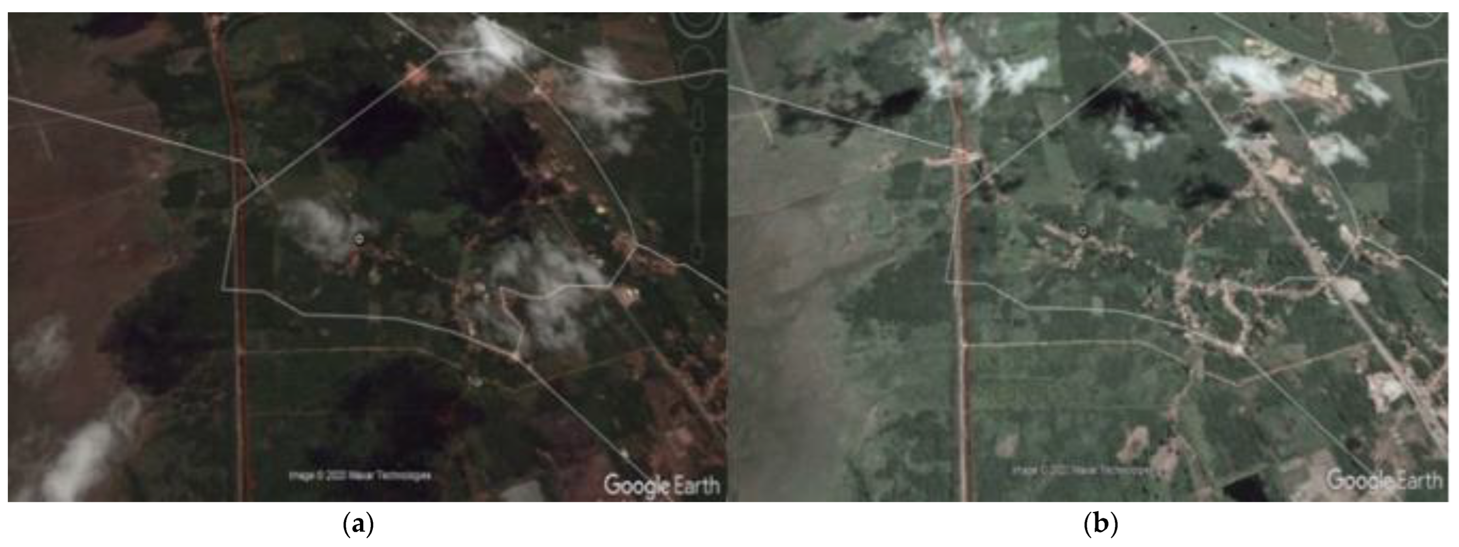
Besides Nova Vitória, Periz de Cima and Km 7 were presented with the highest growth rates. Although Nova Vitória and Km 7 (Figure 8a,b) had images consistent with such growth, Periz de Cima does not appear to have presented such significant change in the number of homes, despite having changes in the ground cover, for example, with the construction of a viaduct over the railroad in the northwest portion of the community’s location (Figure 9a,b). Km 7 is directly crossed by the railroad, although Periz de Cima is located very close to it.
Other communities, such as Nova Vida and São Benedito, had essentially no demographic change, which is also confirmed by the image. Even though São Benedito had some changes in the land cover (with a reduction of vegetation cover mainly in its northern and southern portions), changes in both communities’ households were not significant (Figure 10a,b). The socioeconomic data show a low reduction in the growth of these areas, and in Vila Pindaré and Cariongo 3, all of which were rural. Among these four communities, the railroad crosses all but São Benedito.
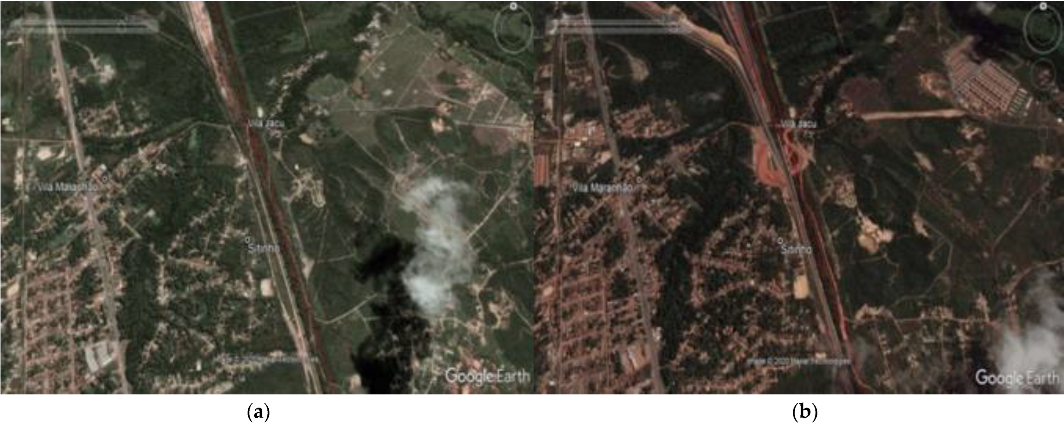
Vila Maranhão, Vila Jacu, and Sitinho are three communities very close to each other in São Luís, Maranhão. The location had a significant change in land cover between 2010 and 2017, especially the one closest to Vila Jacu, located next to the railroad, where viaducts were built over it by the railway concessionaire (Figure 11a,b). Except for Vila Jacu, a rural community, the others are urban ones crossed by the railroad or located next to it.
Urban communities have better socioeconomic conditions and are closer to the railroad than rural. Simultaneously, communities in Maranhão (which are in a less sustainable situation than those in Pará) are closer to the railroad than their counterparts in Pará. The community-railroad distance directly influences the socioeconomic conditions of the communities. This influence can be positive using the urban-rural cut-off; however, it can also be harmful if we consider the communities of Maranhão. This result indicates that such differences can also be related to other factors—such as history—confirming the third hypothesis of this research.
Four communities are far less than 5 km from urban centers (they are the closest to these centers). Among them, only one is in the state of Pará, whereas the others are distant from these centers (see Table S2). Six communities are located between 5 km and 10 km from urban centers, with an emphasis in Marabá, on the three communities; the latter are urban and within the municipality despite being 7 km away from the municipal headquarters. Meanwhile, the other 12 communities are more than 10 km away from urban centers.
Six (out of 10) communities in Pará are less than 10 km away from urban centers, whereas, on the Maranhão side of the railroad, only eight (out of 22) communities analyzed are within this proximity, illustrating the difficulty of access that they have, which may be directly related to our finding that the communities in Maranhão have worse socioeconomic conditions in comparison to those in Pará.
The results show that most communities had socioeconomic indicators consistent with satellite image changes. Overall, the communities on the Maranhão side of the railroad almost always appear among those with the worst socioeconomic indicators, e.g., the Cariongo 3, São Benedito, and Atraca located in Miranda do Norte, Igarapé do Meio, and Tufilândia municipalities, respectively, demonstrating the greater difficulties they face in achieving sustainability. These findings support the need for action to reduce risks, increase community resilience, and to always seek the achievement of more sustainable conditions [7,48,49].
Many studies on the Amazon call attention to its eastern portion, where there is a relationship between mining and the municipalities’ conditions and population [8,23,50]. This study confirms the importance of research involving municipalities and communities influenced by mining. It highlights the need for action to achieve more sustainable conditions since analyses have shown that a lack of sustainability still prevails in most of the communities studied.
In 2010, in five variables (out of six that showed statistically significant results, confirming differences between urban and rural communities), the urban communities had the highest averages, the opposite occurring in only one (households in poverty). In 2017, only five were significant, confirming the higher means in urban communities in three variables, the opposite occurring in only two (the percentage of children and youth and households with motorcycles). For changes between 2010 and 2017, only eight were statistically significant, and we confirmed higher percentage variations among rural communities in seven variables and the opposite in only one (people born in the Federation Unit).
The environmental communities’ conditions are directly related to their location concerning the railroad regardless of whether they were urban or rural. The maps of vegetation cover change in the territory of the EFC in 2010 and 2017 show, overall, a low change in land cover and a predominance in pasture areas. Except for protected areas, indigenous lands, and some fragmented remaining forests, the municipalities of the EFC already had large deforested areas in 2010. We corroborated these findings by the satellite images analysis at the community scale.

4. Discussion

The key findings showed that the urban communities have better socioeconomic conditions (e.g., higher incomes and low poverty) than the rural. Simultaneously, the communities on the Maranhão side of the EFC have worse socioeconomic conditions than those on the Pará’s [5]. The EFC Socioeconomics Atlas also showed that socioeconomic and environmental indicators are mostly worse in the municipalities of Maranhão; the exception is for those close to large urban centers: we found that communities located near large municipalities or those with mining activities typically have better socioeconomic conditions when compared to those more distant. In this line, [2], when analyzing the socioeconomic precariousness on the railroad, found that the municipalities of São Luís, Marabá, Parauapebas, and Canaã dos Carajás, which host large enterprises, present better indicators.
We understand these disparities when previous studies with historical approaches to the Amazon region are analyzed; for instance, [4] and [51] when analyzing the transformations and agents involved in the occupation dynamics of the Amazon region, highlight the complexity of the historical context that involves the significant socioeconomic and environmental changes in this geographic space. These findings demonstrate that the population’s living conditions are also derived from the historical formation of municipalities in the Amazon region.
Based on the socio-economic data and historical and satellite image analysis, we tested the three hypotheses of this research. Our first hypothesis states that the community’s location on the railroad is related to land use and occupation types in the region. The second hypothesis states that such a location directly influences the living conditions of the local population. We accepted these two hypotheses because the communities located very close to the railroad, or crossed by it, are generally those which had the most significant changes in land coverage and use and the highest variation in socio-economic indicators. The third hypothesis of the study affirms that the living conditions of the communities are the effect of the historical formation process of the municipalities of the Amazon region. We also corroborated this, since we found that the process has a pivotal role in the living conditions of locals.
The studies relating to land use with socioeconomic conditions changes in the EFC region do not exist; [8] is among the few studies with a similar approach that is focused on the region. However, rather than examining land-use changes with socioeconomic conditions, it addresses land-use changes resulting from the Carajás Mining Project; it identified that there was a considerable reduction in the area of vegetation covered in the region between 1984 and 2014 and expansion of the non-forest area, or pasture, confirming our results on the study area. Conversely, Desalegn et al. [52] analyzed land-use changes and socioeconomic conditions in a community in Wetabecha Minjaro, central highlands of Ethiopia, between 1975 and 2014. They found an increase in plantations and a considerable decrease in the pasture in the area, which was not linked to better local socioeconomic conditions, contrasting with our findings.
We verified limitations in the data collection of the census tracts: the variation of the polygons of these tracts across censuses, so we choose the most recent one (2010) to allow a fair comparison between censuses at the tracts level; the census tracts data availability since the variables in this scale differ from those at the municipal level by IBGE.

5. Conclusions

Overall, communities had socioeconomic changes and, to some extent, land-use changes, with those on the Maranhão railroad side in a less sustainable situation, especially the Atraca, Cariongo 3, and São Benedito, which had some of the worst performances in the analyzed indicators. The communities of Parauapebas, Marabá, Canaã dos Carajás, Açailândia, and São Luís are in a better condition.
The three hypotheses of this study were accepted. The data directly describe the community residents living conditions. In general, the urban communities presented better conditions. The railroad is directly related to land use and occupation; the latter two features are associated with communities’ location within the territory, influencing the local population’s living conditions.
The study findings can directly help in vulnerability reduction and sustainability improvement in the EFC territory if acknowledged by the policymakers and other stakeholders; identification of the existing socio-economic and environmental problems helps pave the way for their potential solutions. Neglecting such findings can potentially compromise the achievement of the SDGs in the region, especially ending poverty (goal 1), ensuring education (goal 4), reducing inequalities (goal 10), making places inclusive, safe, resilient, and sustainable (goal 11), and protecting, restoring, and promoting sustainable use of ecosystems and halting and reversing degradation (goal 15).
The satellite images and socioeconomic data analysis in defined periods can subsidize actions to reduce risk situations and increase resilience and sustainability through public policies or private initiatives; this is fundamental in rural communities, as they have the worst indicators. Future studies can consider the following features: a higher number of communities and indicators, covering a higher period, and comparing land cover and land use changes in this territory, ensuring constant actions according to the community conditions evolution.
The availability of data at the detailed scale of communities was an important caveat for this work. The mapbiomas platform—a nationwide tool used in our study—only has data for some scales and lacks community-scale information. This issue led us to adapt our work according to this limitation. There are relevant endeavors to overcome in future research. For example, to draw samples of communities around the mines and the port to analyze the relationship between changes in land use and socio-economic conditions, considering, for instance, the communities’ location and the role of topography in this relationship through strategies based on the use of other specific geoprocessing methods, which were not this study focus.
Based on the implications of this paper’s conclusions, we strongly suggest that local managers, policymakers, and other stakeholders should focus their actions on the priority communities since they presented the highest weaknesses in the analyses performed here to guarantee better results in the light of the difficulties in managing a complex territory such as the EFC.

Supplementary Materials

The following supporting information can be downloaded at: https://www.mdpi.com/article/10.3390/su14095132/s1, Table S1: Definition of the collected variables; Table S2: Communities’ location relative to the cities’ centers.

Author Contributions

Conceptualization, L.d.A.C. and V.J.M.; methodology, V.J.M. and L.d.A.C.; software, V.J.M.; formal analysis, M.A.S.; investigation, L.d.A.C.; resources, M.A.S.; data curation, V.J.M.; writing—original draft preparation, L.d.A.C.; writing—review and editing, V.J.M. and M.A.S.; supervision, M.A.S. and V.J.M. All authors have read and agreed to the published version of the manuscript.

Funding

The authors thank the financial support of the Coordination for the Improvement of Higher Education Personnel (CAPES) of Brazil for this research and the support of the Instituto Tecnológico Vale (ITV) in the fieldwork. We are also very grateful to Jorge Filipe dos Santos for his advice in Geomatics and to anonymous referees for their comments and suggestions in the earlier versions of the paper.

Institutional Review Board Statement

Not applicable.

Informed Consent Statement

Not applicable.

Data Availability Statement

Not applicable.

Conflicts of Interest

The authors declare no conflict of interest.

References

  1. Santos, M. Técnica, Espaço, Tempo: Globalização e Meio Técnico-Científico-Informacional, 4th ed.; Hucitec: São Paulo, Brazil, 1998. [Google Scholar]
  2. Santos, J.F.D.; Maia, M.B.; Maneschy, M.C.; Matlaba, V.J.; Mota, J.A. Redes sociais ao longo da estrada de ferro Carajás na Amazônia Oriental. Finisterra-Rev. Port. Geogr. 2018, 109, 149–166. [Google Scholar]
  3. Brito, R.M.D.; Matlaba, V.J.; Imperatriz-Fonseca, V.L.; Giannini, T.C. Perception of Nature’s Contributions to People in Rural Communities in the Eastern Amazon. Sustainability 2020, 12, 7665. [Google Scholar] [CrossRef]
  4. Becker, B. Revisão das políticas de ocupação da Amazônia: É possível identificar modelos para projetar cenários? Parcer. Estratégicas 2010, 6, 135–159. [Google Scholar]
  5. Santos, J.F.D.; Galvão, L.; Mota, J.A.; Matlaba, V.J.; Paes, R. Atlas de Socioeconomia da Estrada de Ferro Carajás: População e Território, Socieconomia, Cidadania. Available online: http://www.itv.org/wp-content/uploads/2020/03/AtlasSocioeconomia.EFC_.PROD_.TEC_.ITV_.DS_N034-_2019-1.pdf (accessed on 20 March 2021).
  6. Cruz, T.L.; Matlaba, V.J.; Mota, J.A.; dos Santos, J.F. Measuring the social license to operate of the mining industry in an Amazonian town: A case study of Canaã dos Carajás, Brazil. Resour. Policy 2021, 74, 101892. [Google Scholar] [CrossRef]
  7. Matlaba, V.J.; Pereira, L.R.; Mota, J.A.; Dos Santos, J.F. Resilience perception of a mining town in eastern Amazonia: A case study of Canaã dos Carajás, Brazil. Environ. Manag. 2021, 67, 698–716. [Google Scholar] [CrossRef]
  8. Santos, D.C.; Souza-Filho, P.W.M.; da Rocha Nascimento, W., Jr.; Cardoso, G.F.; dos Santos, J.F. Land cover change, landscape degradation, and restoration along a railway line in the Amazon biome, Brazil. Land Degrad. Dev. 2020, 31, 2033–2046. [Google Scholar] [CrossRef]
  9. Mitchell, R.; Lee, D. Is there really a “wrong side of the tracks” in urban areas, and does it matter for spatial analysis? Ann. Assoc. Am. Geogr. 2014, 104, 432–443. [Google Scholar] [CrossRef]
  10. Fan, C.; Wang, Z. Spatiotemporal characterization of land cover impacts on urban warming: A spatial autocorrelation approach. Remote Sens. 2020, 12, 1631. [Google Scholar] [CrossRef]
  11. Corteletti, R.C. Proposta de Metodologia Para Análise de Riscos Geológico-Geotécnicos em Ferrovias—Estudo de Caso: Estrada de Ferro Carajás (EFC). Available online: http://www.repositorio.ufop.br/handle/123456789/5060 (accessed on 3 February 2021).
  12. Santos, M.C. Musealização em Projectos de Arqueologia Consultiva: Perspectivas Patrimoniais Para a Estrada de Ferro Carajás (MA/PA). Available online: https://revistas.ulusofona.pt/index.php/cadernosociomuseologia/issue/view/683 (accessed on 12 February 2021).
  13. Damasceno, F.G.; Matlaba, V.J.; dos Santos, J.F.; Mota, J.A. Reaproveitamento de dormentes de madeira da estrada de ferro Carajás para a cogeração de energia elétrica. Braz. J. Environ. Sci. 2017, 45, 1–18. [Google Scholar] [CrossRef]
  14. Araújo, D.R.D.; Santos, M.A.F.D.; Nascimento, P.H.S.D. Otimização do Ciclo Operacional de Transporte dos Vagões de Minério da Estrada de Ferro Carajás-Vale. 2018. Available online: https://repositorio.itl.org.br/jspui/handle/123456789/31 (accessed on 13 May 2021).
  15. Aroudo Mota, J.; Maneschy, M.C.; Souza-Filho, P.W.; Navarro Torres, V.F.; de Siqueira, J.O.; dos Santos, J.F.; Matlaba, V. Uma nova proposta de indicadores de sustentabilidade na mineração. Sustain. Debate/Sustentabilidade Debate 2017, 8, 15–29. [Google Scholar] [CrossRef] [Green Version]
  16. Segerstedt, E.; Abrahamsson, L. Diversity of livelihoods and social sustainability in established mining communities. Extr. Ind. Soc. 2019, 6, 610–619. [Google Scholar] [CrossRef]
  17. Rodrigues, S.J.D.; Palhano, J.E.; Sousa, J.C.C. Modernização do Território e Trabalho Escravo Contemporâneo no Caminho da Estrada de Ferro Carajás-MA. Rev. GeoNordeste 2020, 1, 111–130. [Google Scholar]
  18. PPI—Programa de Parcerias de Investimentos. Available online: https://www.ppi.gov.br/efc-estrada-de-ferro-carajas (accessed on 12 May 2021).
  19. Vale. Available online: http://www.vale.com/PT/initiatives/innovation/s11d/Documents/s11d-2016/assets/doc/revista-vale-s11d.pdf (accessed on 12 May 2021).
  20. IBGE—Instituto Brasileiro de Geografia e Estatística. Available online: https://censo2010.ibge.gov.br/ (accessed on 13 March 2021).
  21. INPE—Instituto Nacional de Pesquisas Espaciais. Plataforma TerraBrasilis—Mapa de Desmatamento (PRODES). Available online: http://terrabrasilis.dpi.inpe.br/ (accessed on 13 March 2021).
  22. Carvalho, T.S. Uso do solo e desmatamento nas regiões da Amazônia legal brasileira: Condicionantes econômicos e impactos de políticas públicas. Ph.D. Thesis, Universidade Federal de Minas Gerais, Belo Horizonte, Brazil, 24 March 2014. [Google Scholar]
  23. Souza-Filho, P.W.M.; Lobo, F.L.; Cavalcante, R.B.L.; Mota, J.A.; Nascimento Jr, W.R. Land use intensity of official mineral extraction in the Amazon region: Linking economic and spatial data. Land Degrad. Dev. 2020, 32, 1706–1717. [Google Scholar] [CrossRef]
  24. Souza-Filho, P.W.M.; Nascimento, W.R.; Santos, D.C.; Weber, E.J.; Silva, R.O. A GEOBIA approach for multitemporal land-cover and land-use change analysis in a tropical watershed in the southeastern Amazon. Remote Sens. 2018, 10, 1683. [Google Scholar] [CrossRef] [Green Version]
  25. Eiselt, B.; Giglioli, N.; Peckham, R. Interregional Migration and Land Use Pressure. In Land Use Simulation for Europe, 1st ed.; Stillwell, J., Scholten, H., Eds.; Springer: Dordrecht, Poland, 2001; pp. 159–170. [Google Scholar]
  26. Ruan, X.; Qiu, F.; Dyck, M. The effects of environmental and socioeconomic factors on land-use changes: A study of Alberta, Canada. Environ. Monit. Assess. 2016, 188, 446. [Google Scholar] [CrossRef]
  27. Instituto Tecnológico Vale. Proposta de Modelo Para Avaliar a Criticidade Social das Comunidades. Relatório Técnico Elaborado Pelo GRUPO de Pesquisa Socioeconomia e Sustentabilidade. 2017. Available online: www.itv.org (accessed on 27 February 2021).
  28. Avzaradel, A.C. Inventário Brasileiro de Emissões Antrópicas por Fontes e Remoções por Sumidouros de Gases de Efeito Estufa não Controlados pelo Protocolo de Montreal. In Mudança do Clima no Brasil; da Motta, R.S., Hargrave, J., Luedemann, G., Gutierrez, M.B.S., Eds.; IPEA: Brasília, Brasil, 2010; pp. 75–87. [Google Scholar]
  29. Bell, S.; Alves, S.; De Oliveira, E.S.; Zuin, A. Migration and land use change in Europe: A review. Living Rev. Landsc. Res. 2010, 4, 1–49. [Google Scholar] [CrossRef] [Green Version]
  30. Bonilla-Moheno, M.; Aide, T.M.; Clark, M.L. The influence of socioeconomic, environmental, and demographic factors on municipality-scale land-cover change in Mexico. Reg. Environ. Chang. 2012, 12, 543–557. [Google Scholar] [CrossRef]
  31. Jokinen, J.C. Migration-related land use dynamics in increasingly hybrid peri-urban space: Insights from two agricultural communities in Bolivia. Popul. Environ. 2018, 40, 136–157. [Google Scholar] [CrossRef] [Green Version]
  32. Cross, J.A. Megacities and small towns: Different perspectives on hazard vulnerability. Glob. Environ. Chang. Part B Environ. Hazards 2001, 3, 63–80. [Google Scholar] [CrossRef]
  33. Vale. Vale Conclui Obra de Expansão da Estrada de Ferro Carajás e Amplia Projetos Sociais no Maranhão. Available online: http://www.vale.com/brasil/pt/aboutvale/news/paginas/expansao-estrada-carajas-projetos-sociais-maranhao.aspx (accessed on 27 February 2021).
  34. Starke, L. Breaking New Ground: Mining, Minerals, and Sustainable Development: The Report of the MMSD Project. Available online: https://pubs.iied.org/9084iied (accessed on 13 December 2021).
  35. Vieira, I.C.G.; Santos Junior, R.A.O.; Toledo, P.M.D. Dinâmicas Produtivas, Transformações no uso da Terra e Sustentabilidade na Amazônia. Rio de Janeiro: Banco Nacional do Desenvolvimento Econômico e Social. Available online: https://web.bndes.gov.br/bib/jspui/bitstream/1408/15060/1/Din%C3%A2micas%20produtivas_14_P_BD.pdf (accessed on 12 March 2021).
  36. Freitas, C.M.; Carvalho, M.L.; Ximenes, E.F.; Arraes, E.F.; Gomes, J.O. Vulnerabilidade socioambiental, redução de riscos de desastres e construção da resiliência: Lições do terremoto no Haiti e das chuvas fortes na Região Serrana, Brasil. Ciência Saúde Coletiva 2012, 17, 1577–1586. [Google Scholar] [CrossRef] [Green Version]
  37. Organização das Nações Unidas. Agenda 2030. Available online: https://nacoesunidas.org/pos2015/agenda2030/ (accessed on 20 March 2021).
  38. Instituto Brasileiro de Geografia e Estatística. IBGE Cidades. Available online: https://cidades.ibge.gov.br/ (accessed on 17 July 2020).
  39. Gujarati, D.N.; Porter, D.C. Basic Econometrics, 5th ed.; McGraw-Hill Irwin: New York, NY, USA, 2009. [Google Scholar]
  40. StataCorp. Data Analysis and Statistical Software. Available online: www.stata.com (accessed on 10 October 2020).
  41. Verma, J.P.; Verma, P. Determining Sample Size and Power in Research Studies. Available online: https://link.springer.com/book/10.1007%2F978-981-15-5204-5 (accessed on 10 October 2020).
  42. Vale. Code of Ethical Conduct. Available online: http://www.vale.com/SiteCollectionDocuments/CodigoEtica/assets/docs/EN_CodigoCondutaEtica_VF.pdf (accessed on 3 October 2020).
  43. Hamby, D.M. A review of techniques for parameter sensitivity analysis of environmental models. Kluwer Academic Publishers. Printed in the Netherlands. Environ. Monit. Assess. 1994, 32, 135–154. [Google Scholar] [CrossRef] [PubMed]
  44. Mann, H.B.; Whitney, D.R. On a test of whether one of two random variables is stochastically larger than the other. Ann. Math. Stat. 1947, 18, 50–60. [Google Scholar] [CrossRef]
  45. Marôco, J. Análise Estatística com o SPSS Statistics, 7th ed. Available online: www.reportnumber.pt/ae (accessed on 10 April 2022).
  46. Nachar, N. The Mann-Whitney U: A test for assessing whether two independent samples come from the same distribution. Tutor. Quant. Methods Psychol. 2008, 4, 13–20. [Google Scholar] [CrossRef]
  47. MapBiomas. Available online: https://plataforma.brasil.mapbiomas.org/ (accessed on 17 July 2020).
  48. Magis, K. Community resilience: An indicator of social sustainability. Soc. Nat. Resour. 2010, 23, 401–416. [Google Scholar] [CrossRef]
  49. Berkes, F.; Ross, H. Community resilience: Toward an integrated approach. Soc. Nat. Resour. 2013, 26, 5–20. [Google Scholar] [CrossRef]
  50. Souza-Filho, P.W.M.; Giannini, T.C.; Jaffé, R.; Giulietti, A.M.; Santos, D.C. Mapping and quantification of ferruginous outcrop savannas in the Brazilian Amazon: A challenge for biodiversity conservation. PLoS ONE 2019, 14, e0211095. [Google Scholar] [CrossRef] [Green Version]
  51. Silva, F.L.D.; Pena, H.W.A.; de Assis Oliveira, F. A Dinâmica da Ocupação da Amazônia Brasileira: Do Interesse Político e Econômico aos Conflitos Socioambientais. Available online: https://www.eumed.net/rev/caribe/2015/01/conflitos-socioambientais.pdf (accessed on 11 May 2021).
  52. Desalegn, T.; Cruz, F.; Kindu, M.; Turrión, M.B.; Gonzalo, J. Land-use/land-cover (LULC) change and socioeconomic conditions of local community in the central highlands of Ethiopia. Int. J. Sustain. Dev. World Ecol. 2014, 21, 406–413. [Google Scholar] [CrossRef]
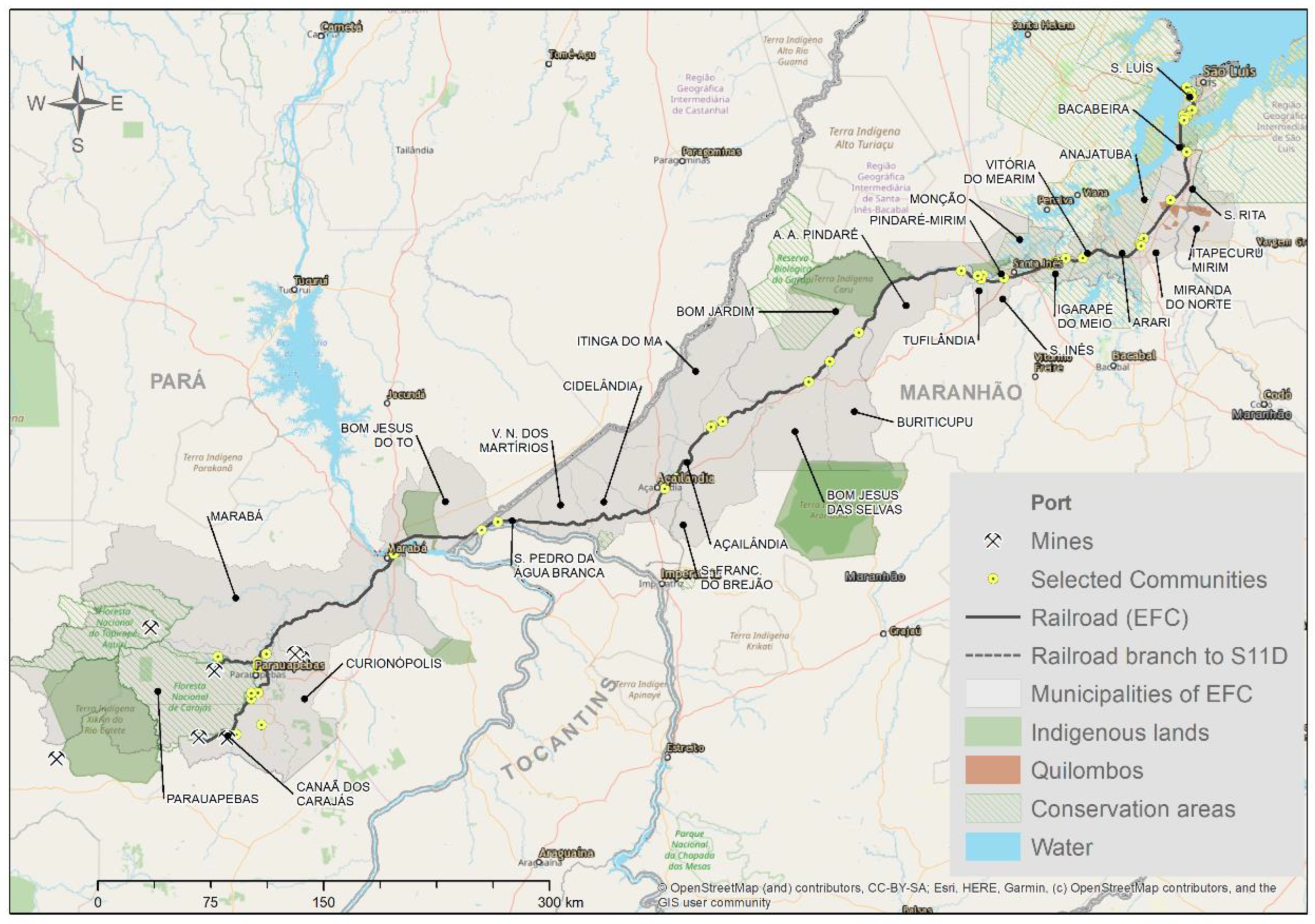
Figure 1. Zone of Influence of the Carajás Railroad. Sources: Prepared by ITV using information from IBGE and Openstreetmaps: OpenStreetMap contributors (2022). Planet dump retrieved from https://planet.osm.org, https://www.openstreetmap.org (accessed on 23 March 2022).
Sustainability 14 05132 g001
Figure 2. Research steps.
Sustainability 14 05132 g002
Figure 3. Communities’ population growth rate, 2010 to 2017.
Sustainability 14 05132 g003
Figure 4. (a) Land cover map of the Pará side of the EFC, 2010. (b) Land cover map of the Pará side of the EFC, 2017.
Sustainability 14 05132 g004
Figure 5. (a) Land cover map of the Maranhão side of the EFC, 2010. (b) Land cover map of the Maranhão side of the EFC, 2017.
Sustainability 14 05132 g005
Figure 6. (a,b). Tropical I, Tropical II and Nova Ipiranga community areas, Parauapebas, Pará, in 2011 and 2017, respectively. Source: Images were taken by the authors from the Google Earth PRO software at: www.earth.google.com (accessed on 23 March 2022).
Sustainability 14 05132 g006
Figure 7. (a,b). Area of the Nova Vitória community, in Parauapebas, Pará, in 2011 and 2017, respectively. Source: Images were taken by the authors from the Google Earth PRO software at: www.earth.google.com (accessed on 23 March 2022).
Sustainability 14 05132 g007
Figure 8. (a,b). Community area Km 7, in Marabá, Pará, in 2010 and 2017, respectively. Source: Images were taken by the authors from the Google Earth PRO software at: www.earth.google.com (accessed on 23 March 2022).
Sustainability 14 05132 g008
Figure 9. (a,b). Periz de Cima community area in Bacabeira, Maranhão, in 2012 and 2017, respectively. Source: Images were taken by the authors from the Google Earth PRO software at: www.earth.google.com (accessed on 23 March 2022).
Sustainability 14 05132 g009
Figure 10. (a,b). São Benedito community area, in Igarapé do Meio (MA), in 2011 and 2017, respectively. Source: Images were taken by the authors from the Google Earth PRO software at: www.earth.google.com (accessed on 23 March 2022).
Sustainability 14 05132 g010
Figure 11. (a,b). An area of the communities Vila Maranhão, Vila Jacu and Sitinho, in São Luís, Maranhão, in 2010 and 2017, respectively. Source: Images were taken by the authors from the Google Earth PRO software at: www.earth.google.com (accessed on 23 March 2022).
Sustainability 14 05132 g011
Table 1. Field data stratification.
SampleParáMaranhãoTotal
Number of municipalities31215
Number of households surveyed72211841906
Total number of communities surveyed133649
Number of excluded communities31417
Number of communities considered102232
Number of households considered68710111698
Table 2. Results of statistical testing of differences in the means between urban and rural communities in 2010.
VariableDifference of averagesMann–Whitney Test
Households820 **z = −3.514; Prob > |z| = 0.0004
Total income$525,427.00 **z = −3.810; Prob > |z| = 0.0001
Poverty−11 **z = 3.366; Prob > |z| = 0.0008
Literacy7 **z = −3.852; Prob > |z| = 0.0001
Radio8 **z = −4.233; Prob > |z| = 0.0000
Occupied population4 **z = −2.860; Prob > |z| = 0.0042
Note: Kolmogorov–Smirnov’s normality test was performed on all variables and, depending on the conclusion of this test, other tests were done: Student’s t, when the data followed a normal distribution, or Mann–Whitney, whose result was confirmed by the Kruskal–Wallis test (result omitted here) when the null hypothesis of data normality was rejected; ** = significant at 5%. The number of observations for each variable was 30. Difference of means = variable average in urban communities minus its average in rural communities. This note is also valid for the Table 3 and Table 4.
Table 3. Results of statistical tests of the differences in the means between urban and rural communities in 2017.
VariableDifference of averagesMann–Whitney Test
Total income$28,889.00 **z = −3.048; Prob > |z|= 0.0023
Cell phone13 **z = −2.312; Prob > |z|= 0.0208
Motorcycle−26 **z = 3.262; Prob > |z|= 0.0011
Note: In 2017, among the variables that presented significant results at 5% (**), only children and young and households with sewage variables had normal distribution; the Student’s t-test were Pr(T > t) = 0.0228; t = 2.09 and Pr(T < t) = 0.0318; t = −1.96, respectively. The number of observations for each variable was 30.
Table 4. Results of the tests for the differences in the means of variations from 2010 to 2017 between urban and rural communities.
VariableDifference in the means of variationsMann–Whitney Test
Poverty−14.2 **z = −2.413; Prob > |z| = 0.0158
Literate people−6.9 **z = 3.937; Prob > |z| = 0.0001
Refrigerator−2.3 **z = 3.387; Prob > |z| = 0.0007
Television−0.4 **z = 2.604; Prob > |z| = 0.0092
Cell phone−5.0 **z = 3.387; Prob > |z| = 0.0007
Motorcycle−10.4 **z = 3.175; Prob > |z| = 0.0015
Natural from the FU3.5 **z = −2.159; Prob > |z| = 0.0308
Househoulds with sewage−69.8 **z = 2.252; Prob > |z| = 0.0243
Note: Among the variables that presented significant results at 5% (**), only the people born in the Federation Unit variable had a normal distribution. Student’s t-test result was Pr(T < t) = 0.0279; t = −1.995. The overall number of observations for households with sewage is 22, whereas for each of the other variables is 30.
Publisher’s Note: MDPI stays neutral with regard to jurisdictional claims in published maps and institutional affiliations.