
Forty Years of Soil and Water Conservation Policy, Implementation, Research and Development in Indonesia: A Review

 ,
,  ,
,  , , ,
, , ,  , , ,
, , ,  , and
, and 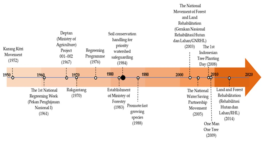
Abstract
1. Introduction
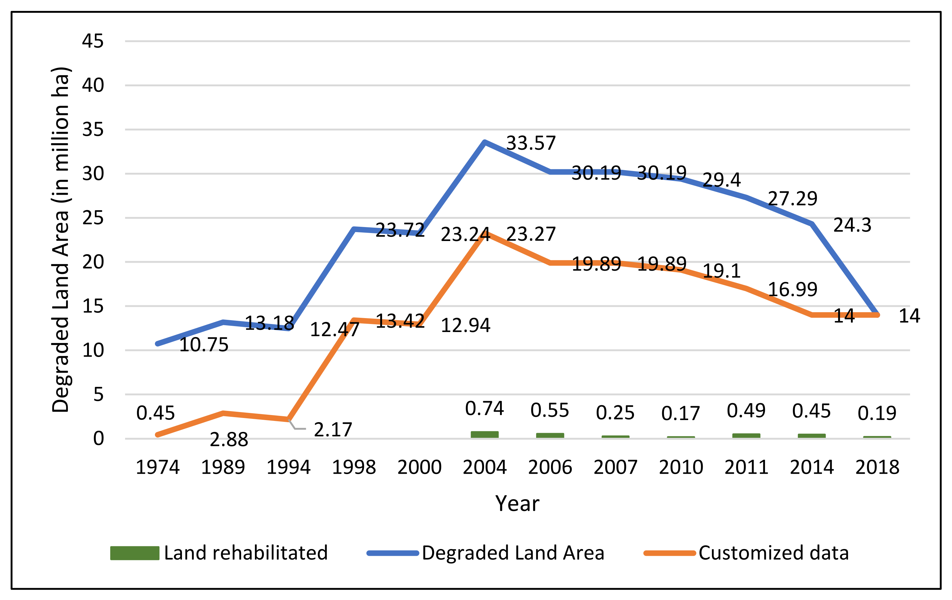
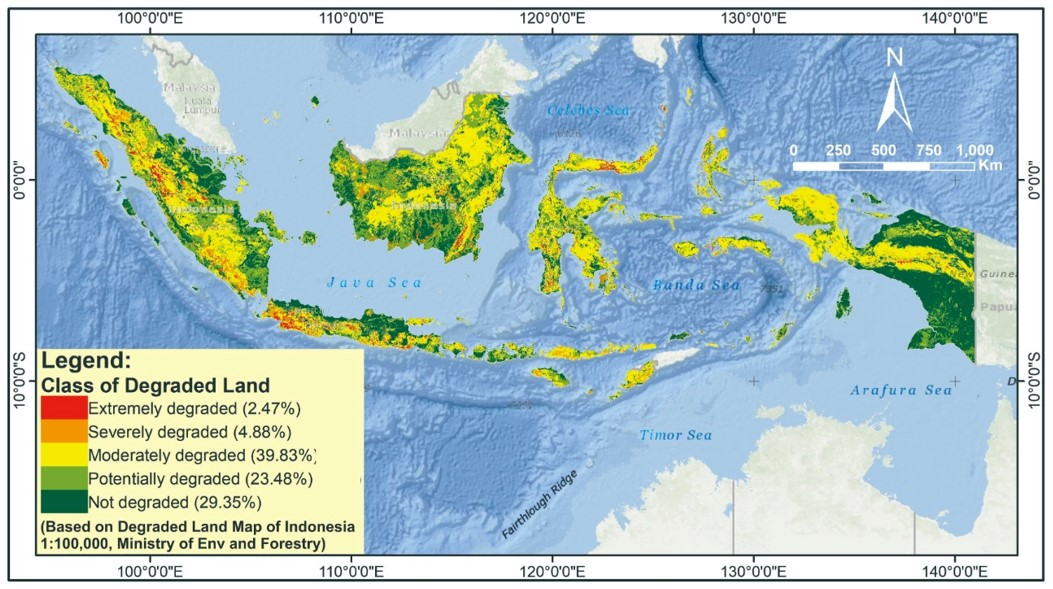
2. Degraded Land Area in Indonesia for the Last Forty Years
3. Regulation, Institution, and Policy of SWC
3.1. Regulation and Rules
3.2. Soil and Water Conservation Institution
3.3. Policy Dynamics
4. Forty Years of SWC Implementation
4.1. Sloping Land Conservation
4.1.1. Mechanical SWC Measures
4.1.2. Vegetative SWC Measures
4.2. Soil and Water Conservation of Mangrove and Peatland
4.2.1. Rewetting
4.2.2. Revegetation
4.3. Water Resource Management
4.4. Community-Based SWC Approach
5. Research, Development, and Innovation 1980–2020
5.1. History of SWC R&D
5.1.1. Period of 1970–1980
5.1.2. Period of 1980–1991
5.1.3. Period of 1991–2020
5.1.4. Period of 2020–Onwards
5.2. R&D Policy Direction: Evolving Concept of Indonesian Soil Water Conservation Research & Development
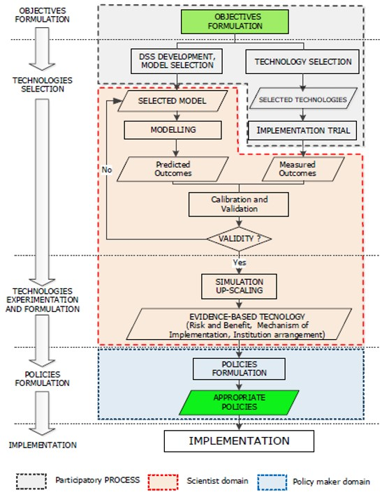
- Developing techniques for measuring various parameters of SWC to automatically support soil preservation, land, and watershed functions (smart systems, such as the utilization of satellites, computers, etc.). From various water conservation techniques that have been applied, information is still needed on the effectiveness of each technique in increasing infiltration because the application of a certain technique specifically depends on climate, soil, and topography [144].
- Sharpening the parameters of SWC to create an appropriate monitoring system (high precision). Soil conservation strategies often adopt traditional practices, for example, the application of terracing, which has been known for thousands of years. However, soil conservation practices that are currently implemented still require effective scientific research to find appropriate designs for its efficient achievement [145]. For example, applying a terracing system must consider the proper dimensions, characteristics of the soil and topography, climatic conditions, the availability of supporting materials, and the objectives to be achieved [144].
- Make more detailed research related to the socio-economic characteristics of the community to formulate an approach so that the community understands the function of soil and land that must be managed sustainably. The application of soil conservation mostly only pays attention to the biophysical aspect. The lack of socio-economic and community culture consideration often results in low acceptance of farmers or land users [146]. Studies need to be conducted to explore the socio-economic and cultural aspects of the community that can encourage acceptance of soil conservation measures and understanding as to what obstacles may be encountered in its implementation [2,147].
- In implementing SWC technologies, attention to the institutional approach should be improved. Therefore, research related to institutional and community support related to land management, especially on degraded watersheds, should be undertaken. To effectively implement an SWC, political support is needed in the form of laws and regulation products agreed upon by all stakeholders, including the land user community [2]. Currently, research is still needed relating to increasing active community participation in the implementation of SWC [6]. The involvement is not only for government stakeholders but also the private sector and continues to encourage the implementation of payment environmental services arrangements. Appropriate policy support through legislation needs to be carried out through a study so that the obstacles in government authority distribution in the implementation of the SWC can be bridged and supported by government officials at the site level.
5.3. State of the Art of SWC R&D in Indonesia
5.3.1. R&D of SWC at Dryland Areas
5.3.2. R&D of SWC in Peatland Area
5.3.3. Agroforestry as an Integrated Soil and Water Conservation Measure
6. Bridging the Gap
6.1. Research–Policy Gap
- Limited funding sources
- b.
- Supporting data constraint
- c.
- Non-linearity of research and policy needs
- d.
- The gap between research language and policy language
6.2. Policy Implementation Gap
7. Closing Note
8. Conclusions
Author Contributions
Funding
Institutional Review Board Statement
Informed Consent Statement
Data Availability Statement
Acknowledgments
Conflicts of Interest
References
- Pimentel, D.; Burgess, M. Soil Erosion Threatens Food Production. Agriculture 2013, 3, 443–463. [Google Scholar] [CrossRef]
- Albaladejo, J.; Díaz-Pereira, E.; de Vente, J. Eco-Holistic Soil Conservation to support Land Degradation Neutrality and the Sustainable Development Goals. Catena 2021, 196, 104823. [Google Scholar] [CrossRef]
- Engdawork, A.; Bork, H.-R. Long-Term Indigenous Soil Conservation Technology in the Chencha Area, Southern Ethiopia: Origin, Characteristics, and Sustainability. AMBIO 2014, 43, 932–942. [Google Scholar] [CrossRef]
- Issaka, S.; Ashraf, M.A. Impact of soil erosion and degradation on water quality: A review. Geol. Ecol. Landsc. 2017, 1, 1–11. [Google Scholar] [CrossRef]
- Sartori, M.; Philippidis, G.; Ferrari, E.; Borrelli, P.; Lugato, E.; Montanarella, L.; Panagos, P. A linkage between the biophysical and the economic: Assessing the global market impacts of soil erosion. Land Use Policy 2019, 86, 299–312. [Google Scholar] [CrossRef]
- de Graaff, J.; Aklilu, A.; Ouessar, M.; Asins-Velis, S.; Kessler, A. The development of soil and water conservation policies and practices in five selected countries from 1960 to 2010. Land Use Policy 2013, 32, 165–174. [Google Scholar] [CrossRef]
- Supari; Tangang, F.; Juneng, L.; Aldrian, E. Observed changes in extreme temperature and precipitation over Indonesia. Int. J. Clim. 2017, 37, 1979–1997. [Google Scholar] [CrossRef]
- FAO/UNEP. A Suggested National Soils Policy for Indonesia; Food Agriculture Organization: Rome, Italy, 1994. [Google Scholar]
- Adimihardja, A. Teknologi Dan Strategi Konservasi Tanah dalam Kerangka Revitalisasi Pertanian. Pengemb. Inov. Pertan. 2008, 1, 105–124. [Google Scholar]
- Badan Pusat Statistik. Penduduk 15 Tahun Ke Atas yang Bekerja menurut Lapangan Pekerjaan Utama 2011–2021; Badan Pusat Statistik: Jakarta, Indonesia, 2021. Available online: https://www.bps.go.id/statictable/2009/04/16/970/penduduk-15-tahun-ke-atas-yang-bekerja-menurut-lapangan-pekerjaan-utama-1986---2018.html (accessed on 15 December 2021).
- Sumiahadi, A.; Acar, R. Soil Erosion in Indonesia and Its Control. In Proceedings of the International Symposium for Environmental Science and Engineering Research (ISESER), Konya, Turkey, 25–27 May 2019. [Google Scholar]
- Susilowati, S.H.; Maulana, M. Luas Lahan Usaha Tani dan Kesejateraan Petani: Eksistensi Petani Gurem dan Urgensi Kebijakan Reforma Agraria. Anal. Kebijak. Pertan. 2016, 10, 17–30. [Google Scholar] [CrossRef]
- Prayitno, B.; Qomarun, Q. Morfologi Kota Solo (Tahun 1500-2000). Dimens. J. Arch. Built Environ. 2007, 35, 80–87. [Google Scholar] [CrossRef]
- Ministry of Environment and Forestry. Statistik Kementerian Lingkungan Hidup dan Kehutanan Tahun 2018; Kementerian Lingkungan Hidup dan Kehutanan: Jakarta, Indonesia, 2019; p. 301.
- Kurnia, U.; Sutrisno, N.; Sungkawa, I. Perkembangan lahan kritis. In Membalik Kecenderungan Degradasi Sumber Daya Lahan Dan Air; Suradisastra, K., Pasaribu, S.M., Sayaka, B., Dariah, A., Las, I., Pasandaran, E.H., Eds.; IPB Press: Bogor, Indonesia, 2010. [Google Scholar]
- Manalu, J.E.R. KLHK Revisi Luasan Lahan Kritis. Available online: https://ekonomi.bisnis.com/read/20180705/99/813322/klhk-revisi-luasan-lahan-kritis (accessed on 22 February 2022).
- Law Number 5/1960 about Basic Regulations on Agrarian Principles; Government of Indonesia: Jakarta, Indonesia, 1960.
- Government of Indonesia. Law Number 5/1967 about Basic Forestry Provisions; Government of Indonesia: Jakarta, Indonesia, 1967.
- Law Number 37/2014 about Soil and and Water Conservation; Government of Indonesia: Jakarta, Indonesia, 2014.
- Narendra, B.H.; Siregar, C.A.; Dharmawan, I.W.S.; Sukmana, A.; Pratiwi; Pramono, I.B.; Basuki, T.M.; Nugroho, H.Y.S.H.; Supangat, A.B.; Setiawan, O.; et al. A Review on Sustainability of Watershed Management in Indonesia. Sustainability 2021, 13, 11125. [Google Scholar] [CrossRef]
- Pratiwi; Narendra, B.; Siregar, C.; Turjaman, M.; Hidayat, A.; Rachmat, H.; Mulyanto, B.; Suwardi; Iskandar; Maharani, R.; et al. Managing and Reforesting Degraded Post-Mining Landscape in Indonesia: A Review. Land 2021, 10, 658. [Google Scholar] [CrossRef]
- Government of Indonesia. Law Number 17/2019 about Water Resources; Government of Indonesia: Jakarta, Indonesia, 2019.
- Government of Indonesia. Government Regulation Number 37/2012 about Watershed Management; Government of Indonesia: Jakarta, Indonesia, 2012.
- Ministry of Public Works and Housing. Decree Number 16/2020 about Organization and Working Procedure in Ministry of Public Works and Housing; Ministry of Public Works and Housing: Jakarta, Indonesia, 2020.
- Raharjo, S.A.S.; Purwanto; Haryanti, N. Management of Bribin Watershed post implementation of law no. 23/2014 on local government. J. Penelit. Ekosist. Dipterokarpa 2020, 6, 33–40. [Google Scholar] [CrossRef]
- Kementerian Pertanian. Rencana Strategis Kementerian Pertanian Tahun 2020–2024; Kementerian Pertanian: Jakarta, Indonesia, 2020.
- Supangat, A.; Indrawati, D.; Wahyuningrum, N.; Purwanto, P.; Donie, S. Membangun Proses Perencanaan Pengelolaan Daerah Aliran Sungai Mikro Secara Partisipatif: Sebuah Pembelajaran (Developing a participatory planning process of micro-watershed management: A lesson learned). J. Penelit. Pengelolaan Drh. Aliran Sungai 2020, 4, 17–36. [Google Scholar] [CrossRef]
- Yulizar; Hikmat, A.; Koesmaryandi, N. Konservasi damar mata kucing (Shorea javanica) berbasis masyarakat di zona tradisional Taman Nasional Bukit Barisan Selatan. Media Konserv. 2014, 19, 73–80. [Google Scholar] [CrossRef]
- Purwanto. Sertifikasi Ekolabel Hutan Rakyat, Menguntungkan Kah; Sebelas Maret University Press: Surakarta, Indonesia, 2018. [Google Scholar]
- Biot, Y.; Blaikie, P.M.; Jackson, C.; Palmer-Jones, R. Rethinking Research on Land Degradation in Developing Countries. In Land Reform and farm restructuring in Moldova; World Bank Publications: Washington, DC, USA, 1995; p. 152. [Google Scholar] [CrossRef]
- Shiferaw, B.A.; Okello, J.J.; Reddy, R.V. Adoption and adaptation of natural resource management innovations in smallholder agriculture: Reflections on key lessons and best practices. Environ. Dev. Sustain. 2007, 11, 601–619. [Google Scholar] [CrossRef]
- Nawir, A.A.; Murniati; Rumboko, L. Forest Rehabilitation in Indonesia. Where to after More Than Three Decades; Center for International Forestry Research (CIFOR): Bogor, Indonesia, 2007. [Google Scholar]
- Chambers, R.; Thrupp, L.A. Farmer First: Farmer Innovation and Agricultural Research; Karthala Editions: Paris, France, 1994. [Google Scholar]
- Van den Hoek, A. Planning as a Learning process. In A Strategy for Planning Land Use Programmes at Local Level with Special Reference to the Uplands of Java; Wageningen University: Wageningen, The Netherlands, 1992. [Google Scholar]
- Reij, C. Indigenous Soil and Water Conservation in Africa; Sustainable Agriculture Programme of the International, Institute for Environment and Development: Amsterdam, The Netherlands, 1991. [Google Scholar]
- Pambudi, A.S. Watershed Management in Indonesia: A Regulation, Institution, and Policy Review. Indones. J. Dev. Planning 2019, 3, 185–202. [Google Scholar] [CrossRef]
- Huszar, P.C.; Cochrane, H.C. Subsidisation of Upland Conservation in West Java: The Citanduy II Project1. Bull. Indones. Econ. Stud. 1990, 26, 121–132. [Google Scholar] [CrossRef]
- Sinukaban, N. Tantangan konservasi tanah dan air di Indonesia: Tinjauan kritis UU no 37/2014 tentang Konservasi Tanah dan Air. In Proceedings of the 59th Anniversary of Faculty Agriculture, University of Brawijaya, Reshaping Agriculture Development for Anticipating Environmental Disruption and Uncertainty on Market Competitiveness, Malang, Indonesia, 8 November 2019. [Google Scholar]
- Sinukaban, N. Impacts of Upland Agriculture and Conservation Project (UACP) on Sustainable Agriculture Development in Serang Watershed, Indonesia. In Proceedings of the 10th International Soil Conservation Organization Meeting, West Lafayette, IN, USA, 23–28 May 1999; pp. 186–190. [Google Scholar]
- Syam, A. Sistem Pengelolan Lahan Kering di Daerah Aliran Sungai Bagian Hulu. J. Litbang Pertan. 2003, 22, 162–171. [Google Scholar]
- Dwiprabowo, H.; Ginoga, K.L. Analisis Kinerja Proyek UPSA Sebagai Suatu Strategi Rehabilitasi Lahan Kritis di Daerah Aliran Sungai Solo, Jawa Tengah. J. Penelit. Has. Hutan 1995, 13, 132–143. [Google Scholar] [CrossRef]
- Dariah, A.; Subagyo, H.; Tafakresnanto, C.; Marwanto, S. Kepekaan Tanah Terhadap Erosi. In Teknologi Konservasi pada Lahan Kering Berlereng; Kurnia, U., Rachman, A., Dariah, A., Eds.; Badan Penelitian dan Pengembangan Pertanian, Departemen Pertanian: Bogor, Indonesia, 2004; pp. 27–30. [Google Scholar]
- Wahyudi. Teknik Konservasi Tanah serta Implementasinya pada Lahan Terdegradasi dalam Kawasan Hutan. J. Sains Teknol. Lingkung. 2014, 6, 71–85. [Google Scholar] [CrossRef]
- Adi, R.N.; Indrajaya, Y. Alternatif penanganan longsoran tebing sungai dengan tanaman bambu. In Proceedings of the Sosialiasi Hasil Penelitian BP2TPDAS, Surakarta, Indonesia, 21 November 2006. [Google Scholar]
- Donie, S. Faktor Fisik yang Mempengaruhi Perkembangan Ujung Jurang Studi Kasus di Daerah Tangkapan Waduk Wonogiri. Bul. Teknol. Pengelolaan DAS 1995, 2, 9–25. [Google Scholar]
- Donie, S.; Harjadi, B.; Wahyuningrum, N.; Adi, R.N. Pengendalian Erosi Jurang: Suatu Upaya Pencapaian Keberhasilan Rehabilitasi Hutan dan Lahan; Balai Penelitian dan Pengembangan Teknologi Pengelolaan DAS: Surakarta, Indonesia, 2018; pp. 1–113. [Google Scholar]
- Dirjen PDASHL. Laporan Kinerja Direktorat Jendral Pengendalian DAS dan Hutan Lindung 2020; Direktorat Jendral Pengendalian DAS dan Hutan Lindung, Kementrian Lingkungan Hidup dan Kehutanan: Jakarta, Indonesia, 2020; pp. 1–94.
- Nugroho, H.Y.S.H.; Sallata, M.K.; Isnan, W.; Saad, M.; Hermawan, A. Effectiveness of soil and water conservation structures in increasing community perception and controlling erosion and sedimentation. IOP Conf. Series Earth Environ. Sci. 2021, 874, 012012. [Google Scholar] [CrossRef]
- Ayu, I.W.; Kusumawardani, W.; Wartiningsih, A. Peningkatan kapasitas petani untuk mencegah degradasi lahan pertanian berlereng di lahan kering Desa Pelat, Kecamatan Unter Iwes, Sumbawa. Agroinotek 2020, 1, 34–42. [Google Scholar]
- Suprayogo, D.; Prayogo, C.; Saputra, D.D.; Sari, R.R.; Nugraha, A.; Hadiwijoyo, E.; Andhika, Y.; Ishaq, R.M.; Purnamasari, E.; Irawan, D.B. The Capacity of Community on Running Soil and Water Conservation in Bangsri Micro-Catchment, Upper Brantas Watershed, Indonesia; IOP Publishing: Bristol, UK, 2019; Volume 393. [Google Scholar]
- Supangat, A.B.; Agus, C.; Wahyuningrum, N.; Indrawati, D.R. Soil and Water Conservation Planning Toward Sustainable Management of Upstream Watershed in Indonesia. In Sustainability in Natural Resources Management and Land Planning; Leal, F.W., Azeiteiro, U.M., Setti, A.F.F., Eds.; World Sustainability Series; Springer: Cham, The Switzerland, 2021; pp. 77–91. [Google Scholar] [CrossRef]
- Putra, P.B.; Agus, C.; Adi, R.N.; Susanti, P.D.; Indrajaya, Y. Land Use Change in Tropical Watersheds: Will It Support Natural Resources Sustainability? In Sustainability in Natural Resources Management and Land Planning; Leal Filho, W., Azeiteiro, U.M., Setti, A.F.F., Eds.; Springer International Publishing: Cham, The Switzerland, 2021; pp. 63–75. [Google Scholar]
- Arisandi, D. Sebaran Spasial Hasil Proses Erosi Parit (Gully Erosion) Yang Berkembang di DAS Bompon Kabupaten Magelang Provinsi Jawa Tengah; Universitas Gadjah Mada: Yogyakarta, Indonesia, 2017. [Google Scholar]
- Erwanto, Z.; Pranowo, D.D.; Gumelar, Y.P.; Wahyudin, I.; Husamadi, M.R. Konservasi Lahan Gully Plugs Untuk Pengendali Erosi Di DAS Badeng Desa Sumberbulu, Songgon, Banyuwangi. J. Pengabdi. Kpd. Masy. 2021, 5, 475–487. [Google Scholar]
- Sarminah, S.; Karyati, K.; Karmini, K.; Simbolon, J.; Tambunan, E. Rehabilitation and soil conservation of degraded land using sengon (Falcataria moluccana) and peanut (Arachis hypogaea) agroforestry system. Biodiversitas J. Biol. Divers. 2018, 19, 222–228. [Google Scholar] [CrossRef]
- Gahrizsangi, H.S.; Eslamian, S.; Dalezios, N.R.; Blanta, A.; Madadi, M. Vegetation Advantages for Water and Soil Conservation; Wiley: Hoboken, NJ, USA, 2021; pp. 321–336. [Google Scholar]
- Bangsawan, I.; Hardjanto, H.; Hero, Y. Dinamika kelompok tani dan pembangunan hutan rakyat di kabupaten serang provinsi banten. J. Penelit. Sos. Èkon. Kehutan. 2016, 13, 1–12. [Google Scholar] [CrossRef]
- Subagyono, K.; Marwanto, S.; Kurnia, U. Teknik Konservasi Tanah Secara Vegetatif; Seri Monograf No. 1 Sumber Daya Tanah Indonesia; Balai Penelitian Tanah: Bogor, Indonesia, 2003; p. 51. [Google Scholar]
- Soendjoto, M.A. Sekilas Tentang Lahan Basah dan Lingkungannya. In Proceedings of the Seminar Universitas Lambung Mangkurat 2015 “Potensi, Peluang, dan Tantangan Pengelolaan Lingkungan Lahan-basah Secara Berkelanjutan”, Banjarmasin, Indonesia, 16 September 2015; pp. 1–20. [Google Scholar]
- Miettinen, J.; Hooijer, A.; Shi, C.; Tollenaar, D.; Vernimmen, R.; Liew, S.C.; Malins, C.; Page, S.E. Extent of industrial plantations on Southeast Asian peatlands in 2010 with analysis of historical expansion and future projections. GCB Bioenergy 2012, 4, 908–918. [Google Scholar] [CrossRef]
- Miettinen, J.; Shi, C.; Liew, S.C. Land cover distribution in the peatlands of Peninsular Malaysia, Sumatra and Borneo in 2015 with changes since 1990. Glob. Ecol. Conserv. 2016, 6, 67–78. [Google Scholar] [CrossRef]
- Uda, S.K.; Hein, L.; Sumarga, E. Towards sustainable management of Indonesian tropical peatlands. Wetl. Ecol. Manag. 2017, 25, 683–701. [Google Scholar] [CrossRef]
- Yuwati, T.W.; Rachmanadi, D.; Pratiwi; Turjaman, M.; Indrajaya, Y.; Nugroho, H.Y.S.H.; Qirom, M.A.; Narendra, B.H.; Winarno, B.; Lestari, S.; et al. Restoration of Degraded Tropical Peatland in Indonesia: A Review. Land 2021, 10, 1170. [Google Scholar] [CrossRef]
- Yuwati, T.W.; Rachmanadi, D.; Qirom, M.A.; Santosa, P.B.; Kusin, K.; Tata, H.L. Peatland Restoration in Central Kalimantan by Rewetting and Rehabilitation with Shorea balangeran. In Tropical Peatland Eco-Management; Osaki, M., Tsuji, N., Foead, N., Rieley, J., Eds.; Springer: Singapore, 2021; pp. 595–611. [Google Scholar] [CrossRef]
- Kusmana, C. Lesson learned from mangrove rehabilitation program in indonesia. J. Pengelolaan Sumberd. Alam Lingkung. 2017, 7, 89–97. [Google Scholar] [CrossRef]
- Kusmana, C. Distribution and Current Status of Mangrove Forests in Indonesia. In Mangrove Ecosystems of Asia; Springer: New York, NY, USA, 2013; pp. 37–60. [Google Scholar] [CrossRef]
- Kasih, R.C.; Simon, O.; Ansori, M.M.; Pratama, M.P.; Wirada, F. Rewetting of Degraded Tropical Peatland by Canal Blocking Technique in Sebangau National Park, Central Kalimantan, Indonesia. In Proceedings of the 15th International Peat Congress “Peatlands in Harmony”, Kuching, Malaysia, 15–19 August 2016; pp. 467–471. [Google Scholar]
- Lamers, L.P.M.; Vile, M.A.; Grootjans, A.P.; Acreman, M.C.; van Diggelen, R.; Evans, M.G.; Richardson, C.J.; Rochefort, L.; Kooijman, A.M.; Roelofs, J.G.M.; et al. Ecological restoration of rich fens in Europe and North America: From trial and error to an evidence-based approach. Biol. Rev. 2015, 90, 182–203. [Google Scholar] [CrossRef] [PubMed]
- Ritzema, H.; Limin, S.; Kusin, K.; Jauhiainen, J.; Wösten, H. Canal blocking strategies for hydrological restoration of degraded tropical peatlands in Central Kalimantan, Indonesia. Catena 2014, 114, 11–20. [Google Scholar] [CrossRef]
- BRG. Mengawali Restorasi Gambut Indonesia; Badan Restorasi Gambut: Jakarta, Indonesia, 2016; p. 93.
- Fauzi, H.; Noor, M.A.; Nugroho, S.B.; Satriadi, T.; Syam’ani; Prihatiningtyas, E.; Rahmiyati. Laporan Akhir. In Pilot Restorasi Gambut Terintegrasi di Kawasan Hutan Lindung Liang Anggang, Kalimantan Selatan; Universitas Lambung Mangkurat: Banjarmasin, Indonesia, 2018; pp. 1–129. [Google Scholar]
- Triadi, L.B.B. Restorasi lahan rawa gambut melalui metode rewetting dan paludikultur. J. Sumber Daya Air 2020, 16, 103–118. [Google Scholar] [CrossRef]
- Darusman, T.; Lestari, D.P.; Arriyadi, D. Management Practice and Restoration of the Peat Swamp Forest in Katingan-Mentaya, Indonesia. In Tropical Peatland Eco-Management; Springer: Singapore, 2021; pp. 381–409. [Google Scholar] [CrossRef]
- Giesen, W. Causes of Peat Swamp Forest Degradation in Berbak Np, Indonesia, and Recommendations for Restoration; IAC-Alterra-Arcadis-wur-Delft Hydraulics-Wetlands International: Wageningen, NL, USA, 2004. [Google Scholar] [CrossRef]
- Graham, L.L.B.; Giesen, W.; Page, S.E. A common-sense approach to tropical peat swamp forest restoration in Southeast Asia. Restor. Ecol. 2016, 25, 312–321. [Google Scholar] [CrossRef]
- Suryadiputra, N.; Dohong, A.; Waspodo, R.; Lubis, I.; Hasudungan, F.; Wibisono, I.T. A Guide to Blocking of Canals and Ditches in Conjunction with the Community. 2005. Available online: https://123dok.com/document/z1emjk3y-guide-blocking-canals-ditches.html (accessed on 15 December 2021).
- Dohong, A.; Aziz, A.A.; Dargusch, P. A Review of Techniques for Effective Tropical Peatland Restoration. Wetlands 2018, 38, 275–292. [Google Scholar] [CrossRef]
- Gunawan, H.; Afriyanti, D.; Dewanto, H.A. Show Windows and Lessons Learned from Peatland Restoration in Indonesia. In Tropical Peatland Eco-Management; Springer: Singapore, 2021; pp. 751–774. [Google Scholar]
- Guan, H.; Ye, Q.; Liu, Z. Urban water resources management for semi-arid region. In Proceedings of the SPIE 5884, Remote Sensing and Modeling of Ecosystems for Sustainability II, San Diego, CA, USA, 1 September, 2005; p. 58840D. [Google Scholar] [CrossRef]
- Ramadan, E. Sustainable Water Resources Management in Arid Environment: The Case of Arabian Gulf. Int. J. Waste Resour. 2015, 5, 3–6. [Google Scholar] [CrossRef]
- Fulazzaky, M.A. Challenges of Integrated Water Resources Management in Indonesia. Water 2014, 6, 2000–2020. [Google Scholar] [CrossRef]
- Bainus, A.; Yulianti, D.; Husin, L.H. Mitigating Natural Disaster In The Midst Of Limitations: Human Security Issues In Overcoming Threat Of Flood In Citarum River Basin, Indonesia. Humanit. Soc. Sci. Rev. 2020, 8, 859–867. [Google Scholar] [CrossRef]
- Junaidi, A.; Nurhamidah, N.; Daoed, D. Future flood management strategies in Indonesia. MATEC Web Conf. 2018, 229, 01014. [Google Scholar] [CrossRef]
- Subagyono, K.; Pawitan, H. Water harvesting techniques for sustainable water resources management in catchments area. In Proceedings of the International Workshop on Integrated Wastershed Management for Sustainable Water Use in Humid Tropical Region, Tsukuba, Japan, 31 October 2007; pp. 18–30. [Google Scholar]
- Bengen, D.; Retraubun, A.S.W.; Saad, S. Menguak Realitas dan Urgensi Pengelolaan Berbasis Eko-Sosio Sistem Pulau-Pulau Kecil, 3rd ed.; Pusat Pembelajaran dan Pengembangan Pesisir dan Laut (P4L): Bogor, Indonesia, 2012; p. 119. [Google Scholar]
- Latuamury, B.; Marasabessy, H.; Talaohu, M.; Imlabla, W. Small island watershed morphometric and hydrological characteristics in Ambon Region, Maluku Province. Proc. IOP Conf. Ser. Earth Environ. Sci. 2021, 800, 012047. [Google Scholar] [CrossRef]
- Kusumartono, F.X.; Rizal, A. An integrated assessment of vulnerability to water scarcity measurement in small islands of Indonesia. World News Nat. Sci. 2019, 24, 117–133. [Google Scholar]
- Kuswardono, P.T.; Mudita, I.W.; Pandie, D.B. The landlords, the peasant, and the retention basin: Local political ecology of water management in the small island of Semau, Kupang, Indonesia. Int. J. Trop. Drylands 2021, 5, 12–19. [Google Scholar] [CrossRef]
- Wiyono, M.B.; Adji, T.N. Analysis of Groundwater Quality for Clean Water Supply in Pasaran Island, Bandar Lampung City, Indonesia. Forum Geogr. 2021, 35, 28–37. [Google Scholar] [CrossRef]
- Medellu, C.S. Variability of Microclimate Daily Dynamic in Small Island. Int. J. Environ. Agric. Biotechnol. 2018, 3, 2168–2176. [Google Scholar] [CrossRef][Green Version]
- Narulita, I.; Rahayu, R.; Kusratmoko, E.; Supriatna, S.; Djuwansah, M. Ancaman Kekeringan Meteorologis di Pulau Kecil Tropis akibat Pengaruh El-Nino dan Indian Ocean Dipole (IOD) Positif, studi kasus: Pulau Bintan. J. Lingkung. Bencana Geol. 2020, 10, 127–138. [Google Scholar] [CrossRef][Green Version]
- Marganingrum, D.; Sudrajat, Y. Estimasi Daya Dukung Sumber Daya Air di Pulau Kecil (Studi Kasus Pulau Pari). J. Wil. Lingkung. 2018, 6, 164–182. [Google Scholar] [CrossRef]
- Kusumartono, F.X.H.; Sapei, A.; Hadi, A.; Anna, Z. Vulnerability Index Formulation For Water Needs Fulfillment On Small Islands (Study case: East Nusa Tenggara Province). Sos. Ekon. Pekerj. Umum 2015, 7, 119–132. [Google Scholar]
- Subagyono, K.; Haryati, U.; Talaohu, S.H. Teknologi Konservasi Air Pada Pertanian Lahan Kering. In Teknologi Konservasi Tanah pada Lahan Kering Berlereng; Kurnia, U., Rachman, A., Dariah, A., Eds.; Balai Penelitian Tanah, Badan Penelitian dan Pengembangan Pertanian: Bogor, Indonesia, 2004; pp. 151–188. [Google Scholar]
- Messakh, J.J.; Sabar, A.; Hadihardaja, I.K.; Dupe, Z. Management strategy of water resources base on rainfall characteristics in the semi-arid region in Indonesia. Int. J. Sci. Eng. Res. 2015, 6, 331–338. [Google Scholar]
- David, W.; Ploeger, A. Indigenous knowledge (IK) of water resources management in West Sumatra, Indonesia. Future Food J. Food Agric. Soc. 2014, 2, 52–60. [Google Scholar]
- Hafif, B. Achieving food sovereignty through water conservation: A review. Agric. Rev. 2016, 37, 133–140. [Google Scholar] [CrossRef][Green Version]
- Lasut, M.T.; Jensen, K.R.; Shivakoti, G. Analysis of constraints and potentials for wastewater management in the coastal city of Manado, North Sulawesi, Indonesia. J. Environ. Manag. 2008, 88, 1141–1150. [Google Scholar] [CrossRef] [PubMed]
- Yustiani, Y.M.; Hasbiah, A.W.; Matsumoto, T.; Rachman, I. Identification of important efforts in urban river water quality management (case study of Cikapundung River, Bandung, Indonesia). IOP Conf. Ser. Earth Environ. Sci. 2019, 245, 012033. [Google Scholar] [CrossRef]
- Siagian, T.H.; Purhadi, P.; Suhartono, S.; Ritonga, H. Social vulnerability to natural hazards in Indonesia: Driving factors and policy implications. Nat. Hazards 2014, 70, 1603–1617. [Google Scholar] [CrossRef]
- Haddis, A.; Van der Bruggen, B.; Smets, I. Constructed wetlands as nature based solutions in removing organic pollutants from wastewater under irregular flow conditions in a tropical climate. Ecohydrol. Hydrobiol. 2020, 20, 38–47. [Google Scholar] [CrossRef]
- Indrawati, D.R.; Awang, S.A.; Faida, L.R.; Maryudi, A. Pemberdayaan Masyarakat dalam Pengelolaan DAS Mikro: Konsep dan Implementasi. J. Kawistara 2016, 6, 113–224. [Google Scholar]
- Dixon, J.A.; Easter, K.W. Integrated Watershed Management: An Approach to Resource Management; Easte, K.W., Dixon, J.A., Hufschimdt, M.M., Eds.; East-West Center, Environment and Policy Institute: Honolulu, Indonesia, 1986; pp. 3–15. [Google Scholar]
- Putro, H.R.; Saleh, M.B.; Hendrayanto; Ichwandi, I.; Sudaryanto. Sistem Insentif Rehabilitasi Lahan Dalam Rangka Pengelolaan Daerah Aliran Sungai; Fakultas Kehutanan IPB: Bogor, Indonesia, 2003. [Google Scholar]
- Murniati; Nawir, A.A.; Rumboko, L.; Gumartini, T. Tinjauan nasional sejarah dan karakteristik kegiatan rehabilitasi. In Rehabilitasi Hutan di Indonesia Akan Kemanakah Arahnya Setelah Lebih Dari Tiga Dasawarsa; Nawir, A.A., Murniati, Rumboko, L., Eds.; Center for International Forestry Research: Bogor, Indonesia, 2008. [Google Scholar]
- Dewi, A.K. Partisipasi Masyarakat dalam Rehabilitasi Lahan pada Program Kebun Bibit Rakyat (KBR) di Desa Plukaran Kecamatan Gembong Kabupaten Pati. J. Pembang. Wil. KOTA 2013, 9, 42. [Google Scholar] [CrossRef]
- Rahadiani, A.A.S.; Dharma, I.G.; Norken, I. Partisipasi Masyarakat Sekitar Danau Beratan Dalam Konservasi Sumber Daya Air. J. Spektran. 2014, 2, 41–49. [Google Scholar] [CrossRef]
- Anatika, E.; Kaskoyo, H.; Febryano, I.G.; Banuwa, I.S. Private Forest Management in Tulang Bawang Barat. J. Sylva Lestari 2019, 7, 42–51. [Google Scholar] [CrossRef]
- Indrawati, D.R. Partisipasi dan Kolaborasi Para Pihak terkait dalam Pengelolaan DAS Mikro Naruan. In Bunga Rampai Membangun Integrasi Pengelolaan DAS di Tingkat Partisipatif; Supangat, A.B., Dharmwan, I.W.S., Eds.; IPB Press: Bogor, Indonesia, 2019; pp. 45–55. [Google Scholar]
- Maridi. Mengangkat Budaya dan Kearifan Lokal dalam Sistem Konservasi Tanah dan Air. In Proceedings of the Seminar Nasional XII Pendidikan Biologi FKIP UNS 2015, Surakarta, Indonesia, 1 November 2015; pp. 20–39. [Google Scholar]
- Alanindra, S. Analisis Vegetasi Pohon di Daerah Tangkapan Air Mata Air Cokro dan Umbul Nila Kabupaten Klaten, Serta Mudal dan Wonosadi Kabupaten Gunungkidul; Gadjah Mada University: Yogyakarta, Indonesia, 2014. [Google Scholar]
- Yeny, I.; Yuniati, D.; Khotimah, H. Kearifan Lokal dan Praktik Pengelolaan Hutan Bambu pada Masyarakat Bali. J. Penelit. Sos. Ekon. Kehutan. 2016, 13, 63–72. [Google Scholar] [CrossRef]
- Roni, N.G.K. Konservasi Tanah dan Air; Fakultas Peternakan, Universitas Udayana: Denpasar, Indonesia, 2015. [Google Scholar]
- Priyono, C.N.S. Petunjuk Teknis Pembangunan DAM Pengendali Sedimen Tipe Busur; Balai Teknologi Pengelolaan Daerah Aliran Sungai: Surakarta, Indonesia, 1996. [Google Scholar]
- Achil, M.E.K. Lahan Kritis: Pengertian dan Kriteria, 2nd ed.; Balai Teknologi Pengelolaan Daerah Aliran Sungai: Surakarta, Indonesia, 1995. [Google Scholar]
- BTPDAS. Pengelolaan DAS Dengan Penanggulangan Lahan Kritis di DAS Samin (Sub DAS Dumpul, Sub DAS Tapan); Balai Teknologi Penelitian Daerah Aliran Sungai: Surakarta, Indonesia, 1988. [Google Scholar]
- BTPDAS. Uji Coba Pengelolaan Daerah Aliran Sungai Sub DAS Gobeh; Balai Teknologi Pengelolaan DAS: Surakarta, Indonesia, 1989. [Google Scholar]
- Fletcher, J.R.; Gibb, R.G. Land Source Survey Handbook for Soil Conservation Planning in Indonesia; Indonesia-New Zealand Land Resources Mapping Project; Ministry of Forestry, Directorate General Reforestation and Land Rehabilitation Indonesia: Jakarta, Indonesia, 1989. [Google Scholar]
- Wardojo; Priyono, C.N.S. Informasi Teknis Konservasi Tanah Pada Budidaya Tebu di Lahan Kering; Balai Teknologi Pengelolaan Daerah Aliran Sungai: Surakarta, Indonesia, 1996. [Google Scholar]
- Wardojo. Informasi Teknis Rehabilitasi Lahan Kritis Dengan Menggunakan Bambu; Balai Teknologi Pengelolaan Daerah Aliran Sungai: Surakarta, Indonesia, 1996. [Google Scholar]
- Wardojo; Priyono, C.N.S. Petunjuk Teknis Pembuatan Sekat Rumput (Grass Barrier); Balai Teknologi Pengelolaan Daerah Aliran Sungai: Surakarta, Indonesia, 1996. [Google Scholar]
- Priyono, C.N.S. Petunjuk Teknis Pengukuran Erosi di Lahan Pertanian; Balai Teknologi Pengelolaan Daerah Aliran Sungai: Surakarta, Indonesia, 1997. [Google Scholar]
- Priyono, C.N.S.; Basuki, T.M.; Triwilaida; Sukresno; Purwanto; Wahyuningrum, N.; Supangat, A.B.; Wardoyo; Paimin; Indrawati, D.R.; et al. Pedoman Praktik Konservasi Tanah dan Air; BPPTPDAS IBB: Surakarta, Indonesia, 2002. [Google Scholar]
- BTPDAS. Banjir, Penyebab dan Solusinya; Balai Teknologi Pengelolaan Daerah Aliran Sungai: Surakarta, Indonesia, 2002. [Google Scholar]
- Siswamartana, S.; Utomo, W.H.; Soedjoko, S.A.; Priyono, C.N.S.; Mulyana, N.M.; Rusdiana, O.; Pramono, I.B. Pinus dan Hasil Air; Balai Penelitian Teknologi Pengelolaan DAS: Surakarta, Indonesia, 2002. [Google Scholar]
- BTPDAS. Banjir dan Tanah Longsor Laporan Evaluasi Bencana Banjir Bandang di Bukit Lawang Kecamatan Bohorok Kabupaten Langkat, Sumatera Utara; Balai Teknologi Pengelolaan DAS: Surakarta, Indonesia, 2003. [Google Scholar]
- BPPTPDASIBB. Pedoman Monitoring dan Evaluasi Pengelolaan Daerah Aliran Sungai; Balai Penelitain dan Pengembangan Teknologi Pengelolaan Daerah Aliran Sungai Wilayah Indonesia Bagian Barat: Surakarta, Indonesia, 2004. [Google Scholar]
- Teknisi, T. Petunjuk Teknis Pengelolaan Daerah Aliran Sungai; Balai Penelitian dan Pengembangan Teknologi Pengelolaan Daerah Aliran Sungai Wilayah Indonesia Barat: Surakarta, Indonesia, 2005. [Google Scholar]
- Sumardi; Atmoko, B.D. Petunjuk Teknis Pembuatan Plot Erosi Dengan Bak Kolektor; Balai Penelitian dan Pengembangan Teknologi Pengelolaan Daerah Aliran Sungai Wilayah Indonesia Bagian Barat: Surakarta, Indonesia, 2006. [Google Scholar]
- Adi, R.N.; Pramono, I.B. Petunjuk Teknis Peralatan Monitoring Tata Air Daerah Aliran Sungai; Balai Penelitian dan Pengembangan Teknologi Pengelolaan Daerah Aliran Sungai Wilayah Indonesia Barat: Surakarta, Indonesia, 2006. [Google Scholar]
- Paimin; Sukresno; Purwanto. Sidik Cepat Degradasi Sub Daerah Aliran Sungai (DAS); Pusat Penelitian dan Pengembangan Konservasi dan Rehabilitasi (P3KR): Bogor, Indonesia, 2012. [Google Scholar]
- Paimin; Sukresno; Pramono, I.B. Teknik Mitigasi Banjir dan Tanah Longsor; Tropenbos International Indonesia Programme: Bogor, Indonesia, 2009. [Google Scholar]
- Pramono, I.B.; Savitri, E.; Donie, S.; Basuki, T.M. Sistem Pengelolaan Daerah Tangkapan Air Waduk; Balai Penelitian dan Pengembangan Teknologi Pengelolaan Daerah Aliran Sungai: Surakarta, Indonesia, 2018. [Google Scholar]
- Purwanto; Harjadi, B.; Supangat, A.B. Belajar Dari Pengalaman Pengelolaan Daerah Aliran Sungai (DAS) Mikro, 1st ed.; UNS Press: Surakarta, Indonesia, 2016; p. 188. [Google Scholar]
- Pramono, I.B.; Savitri, E.; Donie, S.; Basuki, T.M.; Supangat, A.B.; Cahyono, S.A.; Putra, R.B.W.M. Restorasi DAS Ciliwung; UNS Press: Surakarta, Indonesia, 2015; p. 121. [Google Scholar]
- Yuliantoro, D.; Atmoko, B.D.; Siswo. Pohon Sahabat Air; Balai Penelitian dan Pengembangan Teknologi Pengelolaan Daerah Aliran Sungai: Surakarta, Indonesia, 2016. [Google Scholar]
- Riyanto, H.D. Rekayasa Vegetatif Untuk Mengurangi Risiko Longsor; Balai Penelitian dan Pengembangan Teknologi Pengelolaan Daerah Aliran Sungai: Surakarta, Indonesia, 2016. [Google Scholar]
- Purwanto. Aspek ekonomi pengelolaan DAS mikro dan pengaruhnya dalam pemilihan teknik konservasi tanah dan air. In Bunga Rampai Membangun Integrasi Pengelolaan DAS di Tingkat Implementatif; Supangat, A.B., Dharmawan, I.W.S., Eds.; IPB Press: Bogor, Indonesia, 2019. [Google Scholar]
- Basuki, T.M.; Auliyani, D.; Brahmantya, L.; Sudarso; Wahyuningrum, N.; Adi, R.N.; Wijaya, W.W.; Cahyono, S.A.; Indrawati, D.R.; Savitri, E.; et al. Pengelolaan Sumber Daya Air Lestari; IPB Press: Bogor, Indonesia, 2019. [Google Scholar]
- Kementerian Riset Teknologi dan Pendidikan Tinggi. Rencana Induk Riset Nasional Tahun 2017–2045 (Edisi 28 Februari 2017); Kementerian Riset, Teknologi, dan Pendidikan Tinggi: Jakarta, Indonesia, 2017. [Google Scholar]
- Departemen Kehutanan. Renstra Departemen Kehutanan 2005–2009; Departemen Kehutanan: Jakarta, Indonesia, 2005. [Google Scholar]
- Badan Penelitian dan Pengembangan Kehutanan. Roadmap Litbang Kehutanan 2010–2025; Badan Penelitian dan Pengembangan Kehutanan, Kementerian Kehutanan: Jakarta, Indonesia, 2009.
- Kementerian Riset Teknologi dan Pendidikan Tinggi. Prioritas Riset Nasional Tahun 2020–2024. In Peraturan Menteri Riset, Teknologi, dan Pendidikan Tinggi Republik Indonesia Nomor 38 Tahun 2019; Kementerian Riset, T., dan Pendidikan, T., Eds.; Direktur Jenderal Peraturan Perundang-Undangan Kementerian Hukum dan Hak Asasi Manusia, Republik Indonesia: Jakarta, Indonesia, 2009. [Google Scholar]
- Cano, A.; Núñez, A.; Acosta-Martinez, V.; Schipanski, M.; Ghimire, R.; Rice, C.; West, C. Current knowledge and future research directions to link soil health and water conservation in the Ogallala Aquifer region. Geoderma 2018, 328, 109–118. [Google Scholar] [CrossRef]
- Dotterweich, M. The history of human-induced soil erosion: Geomorphic legacies, early descriptions and research, and the development of soil conservation—A global synopsis. Geomorphology 2013, 201, 1–34. [Google Scholar] [CrossRef]
- Mozzato, D.; Gatto, P.; Defrancesco, E.; Bortolini, L.; Pirotti, F.; Pisani, E.; Sartori, L. The Role of Factors Affecting the Adoption of Environmentally Friendly Farming Practices: Can Geographical Context and Time Explain the Differences Emerging from Literature? Sustainability 2018, 10, 3101. [Google Scholar] [CrossRef]
- Dumanski, J. Evolving concepts and opportunities in soil conservation. Int. Soil Water Conserv. Res. 2015, 3, 1–14. [Google Scholar] [CrossRef]
- Las, I.; Agus, F.; Nursyamsi, D.; Husen, E.; Sutriadi, T.; Wiratno; Syahbuddin, H.; Jamil, A.; Ritung, S.; Mulyani, A.; et al. Road Map Penelitian dan Pengembangan Lahan Kering; Balai Besar Penelitian dan Pengembangan Sumberdaya Lahan Pertanian, Badan Penelitian dan Pengembangan, Kementerian Pertanian: Bogor, Indonesia, 2014. [Google Scholar]
- Auliyani, D. Upaya Konservasi Tanah dan Air pada Daerah Pertanian Dataran Tinggi di Sub-Daerah Aliran Sungai Gandul. J. Ilmu Pertan. Indones. 2020, 25, 382–387. [Google Scholar] [CrossRef]
- Rangkuti, D. Analisa dan Pengendalian Erosi Permukaan Pada Sub DAS Batang Angkola Di Tapanuli Selatan; Universitas Sumatera Utara: Medan, Indonesia, 2010. [Google Scholar]
- Rachman, A. Peluang dan Tantangan Implementasi Model Pertanian Konservasi di Lahan Kering. J. Sumberd. Lahan 2020, 11, 77–90. [Google Scholar] [CrossRef]
- Tala’ohu, S.H.; Al-Jabri, M. Mengatasi Degradasi Lahan Melalui Aplikasi Pembenah Tanah (Kajian Persepsi Petani di Kabupaten Malang, Provinsi Jawa Timur). J. Zeolit Indones. 2008, 7, 22–34. [Google Scholar]
- Krisnawati, K.; Rahayu, A.A.D.; Setiawan, O. Pemanfaatan Pupuk Organik dan hidrogel untuk Mendukung Pertumbuhan Mimba Di Sumbawa, Nusa Tenggara Barat. J. Penelit. Kehutan. Faloak 2021, 5, 103–117. [Google Scholar] [CrossRef]
- Narendra, B.H. Pengaruh perbaikan kondisi tanah terhadap pertumbuhan Kaliandra (Calliandra calothyrsus) dan Buni (Antidesma bunius) di Kawasan Konservasi Gunung Batur Bali. J. Penelit. Hutan Konserv. Alam 2012, 9, 101–111. [Google Scholar] [CrossRef][Green Version]
- Narendra, B.H.; Setiawan, O. Nusa Penida Critical karst island: The characteristics and prospects for rehabilitation. In Proceedings of the Second International Conference of Indonesian Forestry Researchers (INAFOR), Jakarta, Indonesia, 27–28 August 2013. [Google Scholar]
- Karti, P.D.M.H.; Budi, S.W.; Mardatin, F. Optimasi Kerja Mycofer dengan Augmentasi Mikroorganisme Tanah Potensial dan Asam Humat untuk Rehabilitasi Lahan Marginal dan Terdegradari di Indonesia. J. Ilmu Pertan. Indones. 2009, 14, 118–132. [Google Scholar]
- Dariah, A.; Nurida Balai, N.L.; Tanah, P.; Besar, B.; Sumberdaya, L.; Pertanian, L.; Pertanian, B.L. Pemanfaatan Biochar Untuk Meningkatkan Produktivitas Lahan Kering Beriklim Kering. Buana Sains 2012, 12, 33–38. [Google Scholar]
- Suwardji; Utomo, W.H.; Sukartono. Kemantapan Agregat Setelah Aplikasi Biochar di Tanah Lempung Berpasir pada Pertanaman Jagung di Lahan Kering Kabupaten lombok Utara. Buana Sains 2012, 12, 61–68. [Google Scholar]
- Pratiwi; Dharmawan, I.W.S. Beberapa teknik konservasi tanah untuk lahan terdegradasi. In IPTEK Silvikultur di Lahan Terdegradasi; IPB Press: Bogor, Indonesia, 2019; pp. 19–38. [Google Scholar]
- Pratiwi; Salim, A.G. Aplikasi teknik konservasi tanah dengan sistem rorak pada tanaman gmelina (Gmelina arborea Roxb) di KHDTK Carita, Baten. J. Penelit. Hutan Konserv. Alam 2013, 10, 273–282. [Google Scholar] [CrossRef]
- Pratiwi; Mindawati, N.; Darwo. Penerapan teknik mulsa vertikal pada lahan terdegradasi di Carita, Provinsi Jawa Barat. J. Penelit. Hutan Tanam. 2019, 9, 39–150. [Google Scholar]
- Pratiwi; Narendra, B.H. Pengaruh teknik konservasi tanah tehadap pertumbuhan pertanaman mahoni (Swietenia macrophylla King) di Hutan Penelitian Carita, Jawa Barat. J. Penelit. Hutan Konserv. Alam 2012, 9, 39–150. [Google Scholar]
- Respatiningrum, A.W.; Brawijaya, U.; Limantara, L.M.; Andawayanti, U. Analisis Debit Limpasan dan Indeks Erosivitas Hujan pada Metode USLE Akibat Variasi Intensitas Hujan dengan Alat Rainfall Simulator. J. Teknol. dan Rekayasa Sumber Daya Air 2021, 1, 467–477. [Google Scholar] [CrossRef]
- Djuwansah, M.R.; Mulyono, A. Assessment model for determining soil erodibility factor in lombok island. J. Ris. Geol. Pertamb. 2017, 27, 164. [Google Scholar] [CrossRef]
- Ikawati, N.; Legono, D.; Yulistiyanto, B. Pemodelan Spasial Erosi Lahan Daerah Tangkapan Air Waduk Logung menggunakan Rusle-GIS berbasis Grid. Pros. Semin. Nas. Geotik 2019, 346–355. [Google Scholar]
- Setiawan, O.; Nugroho, H.Y.S.H. Kualitas aliran Sub DAS Wuno dan Mui DAS Palu. J. Penelit. Hutan Dan Konserv. Alam 2006, 3, 389–400. [Google Scholar] [CrossRef][Green Version]
- Haq, M.F.K.; Brawijaya, U.; Sholichin, M.; Asmaranto, R. Analisa Pendugaan Laju Erosi Dengan Menggunakan Model Agricultural Non Point Source Pollution (AGNPS) Di Sub Das Lesti Kabupaten Malang. J. Teknol. Rekayasa Sumber Daya Air 2021, 1, 180–191. [Google Scholar] [CrossRef]
- Sutrisno, N.; Arsyad, S.; Pawitan, H.; Murtiaksono, K. Prediksi Erosi Skala DAS dengan Model AGNPS (Agricultural Non-Point Source Pollution). Tanah Iklim 2011, 20, 13–23. [Google Scholar]
- Nugroho, H.Y.S.H. Evaluasi Dampak Pengelolaan Lahan Terhadap Kualitas Aliran Sungai dan Pendapatan Petani di Sub DAS Gobeh, Wonogiri, Jawa Tengah; Intitut Pertanian Bogor: Bogor, Indonesia, 2000. [Google Scholar]
- Supangat, A.B.; Sukresno, S. Penerapan model answers untuk pendugaan limpasan dan hasil sedimen pada sub das kawasan hutan pinus di gombong, jawa tengah: Studi pendahuluan. J. Penelit. Hutan Konserv. Alam 2008, 5, 409–422. [Google Scholar] [CrossRef]
- Lusiana, B.; Widodo, R.; Mulyoutami, E.; Nugroho, D.A.; Noordwijk, M.V. Kajian Kondisi Hidrologis DAS Talau, Kabupaten Belu, Nusa Tenggara Timur. In Working Paper No. 59; World Agroforestry Centre (ICRAF): Kenya, Nairobi, 2008; p. 71. [Google Scholar]
- Nandini, R.; Kusumandari, A.; Gunawan, T.; Sadono, R. Assessment of land use impact on hydrological response using Soil and Water Analysis Tool (SWAT) in Babak watershed, Lombok Island, Indonesia. Agric. Nat. Resour. 2019, 53, 635–642. [Google Scholar] [CrossRef][Green Version]
- Saputra, A.W.W.; Zakaria, N.A.; Weng, C.N. Changes in Land Use in the Lombok River Basin and Their Impacts on River Basin Management Sustainability. IOP Conf. Ser. Earth Environ. Sci. 2020, 437, 012036. [Google Scholar] [CrossRef]
- Nugroho, H.Y.S.H. Teknik Rehabilitasi Lahan dan Konservasi Tanah di Lembah Palu; BPPT: Jakarta, Indonesia, 2002; Volume 7. [Google Scholar]
- Bushron, R.; Rachman, L.M.; Baskoro, D.P.T. Projected conservation of agricultural land to prevent detrimental effects of land-use changes upstream Brantas Watershed in Indonesia. In Proceedings of the IOP Conference Series: Earth and Environmental Science, Banda Aceh, Indonesia, 29–30 September 2021; IOP Publishing: Bristol, UK, 2021; Volume 756. [Google Scholar]
- Susilawati. Konservasi tanah dan air di daerah semi kering Propinsi Nusa Tenggara Timur. J. Tek. Sipil Unika Soegijapranata 2006, 3, 33–43. [Google Scholar]
- Nugroho, H.Y.S.H. Petunjuk Teknis: Teknik Konservasi Tanah dan Air pada Lahan Usaha Tani Hortikultura. In Wae Tuwo; BP2TPDAS IBT: Makassar, Indonesia, 2005; Volume 1. [Google Scholar]
- Nugroho, H.Y.S.H. The Use of Silt-Pits for Erosion and Sediment Control in Sloping Agricultural Land. In Proceedings of the International Conference of Indonesia Forestry Researchers III-2015 “Forestry Research to Support Sustainable Timber Production and Self-Sufficiency in Food, Energy, and Water”, Bogor, Indonesia, 21–22 October 2015; pp. 74–80. [Google Scholar]
- Erfandi, D. Teknik Konservasi Tanah Lahan Kering Untuk Mengatasi Degradasi Lahan Pada Desa Mojorejo, Lamongan. Bumi Lestari 2013, 13, 91–97. [Google Scholar]
- Nugroho, H.Y.S.H. Penggunaan Jalur Rumput (Grass Barrier) dalam Kegiatan Rehabilitasi Lahan dan Konservasi Tanah (RLKT) dan Penyediaan Makanan Ternak. Inf. Teknis. BTPDAS Ujung Pandang. 1997, 1, 1–23. [Google Scholar]
- Nurdin, N. Kombinasi teknik konservasi tanah dan pengaruhnya terhadap hasil jagung dan erosi tanah pada lahan kering di sub das biyonga kabupaten gorontalo. J. Teknol. Lingkung. 2016, 13, 245–252. [Google Scholar] [CrossRef][Green Version]
- Narendra, B.H.; Syahidan, S. Tanaman penutup tanah yang sesuai pada lahan kritis bekas tambang batu apung. J. Penelit. Hutan Konserv. Alam 2006, 3, 357–365. [Google Scholar] [CrossRef][Green Version]
- Indrajaya, Y.; Yuwati, T.W.; Lestari, S.; Winarno, B.; Narendra, B.H.; Nugroho, H.Y.; Rachmanadi, D.; Pratiwi; Turjaman, M.; Adi, R.N.; et al. Tropical Forest Landscape Restoration in Indonesia: A Review. Land 2022, 11, 328. [Google Scholar] [CrossRef]
- Matatula, J. Upaya Rehabilitasi Lahan Kritis dengan Penerapan Teknologi Agroforestri Sistem Silvopastural di Desa Oebola Kecamatan Fatuleu Kabupaten Kupang. Inotek 2009, 13, 63–74. [Google Scholar]
- Affandi, D. Alternatif bangunan air untuk penyediaan air baku di pulau gili-gili, nusa tenggara barat. J. Air Indones. 2018, 6, 178–187. [Google Scholar] [CrossRef]
- Fahrudin, F.; Idris, M.; Mahrup, M. Study of water management on rainfed land in downstream Renggung watershed. Meteorol. Hydrol. Water Manag. 2017, 5, 29–35. [Google Scholar] [CrossRef][Green Version]
- Made, S.S.; Made, A. Sustainable dryland management strategy in Buleleng Regency of Bali, Indonesia. J. Dryland Agric. 2021, 7, 88–95. [Google Scholar] [CrossRef]
- Sudiajeng, L.; Wiraga, I.W.; Parwita, I.G.L. Inovasi Sumur Imbuhan untuk Pemanenan Air Hujan Domestik. J. Log. 2016, 16, 155–160. [Google Scholar]
- Mustawa, M.; Abdullah, S.H.; Mahardhian, G.D.P. Analisis Efisiensi Irigasi Tetes pada Berbagai Tekstur Tanah untuk Tanaman Sawi (Brassica juncea). J. Ilm. Rekayasa Pertan. Biosist. 2017, 5, 408–421. [Google Scholar] [CrossRef]
- Witman, S. Penerapan Metode Irigasi Tetes Guna Mendukung Efisiensi Penggunaan Air di Lahan Kering. J. Triton 2021, 12, 20–28. [Google Scholar] [CrossRef]
- Anshari, G.Z.; Afifudin, M.; Nuriman, M.; Gusmayanti, E.; Arianie, L.; Susana, R.; Nusantara, R.W.; Sugardjito, J.; Rafiastanto, A. Drainage and land use impacts on changes in selected peat properties and peat degradation in West Kalimantan Province, Indonesia. Biogeosciences 2010, 7, 3403–3419. [Google Scholar] [CrossRef]
- Blackham, G.V.; Webb, E.; Corlett, R. Natural regeneration in a degraded tropical peatland, Central Kalimantan, Indonesia: Implications for forest restoration. For. Ecol. Manag. 2014, 324, 8–15. [Google Scholar] [CrossRef]
- Posa, M.R.C.; Wijedasa, L.S.; Corlett, R.T. Biodiversity and Conservation of Tropical Peat Swamp Forests. Bioscience 2011, 61, 49–57. [Google Scholar] [CrossRef]
- Banjarbaru Forestry Research Institute. Tropical Peat Swamp Forest Silviculture in Central Kalimantan. In A Series of Five Research Papers; Banjarbaru Forestry Research Institute: Banjarbaru, Indonesia, 2014. [Google Scholar]
- Santosa, P.B. Kendala dan upaya meningkatkan keberhasilan penanaman di lahan gambut. Galam 2011, 5, 1–12. [Google Scholar]
- Wetadewi, R.I.; Osaki, M.; Turjaman, M.; Antonius, S.; Goenadi, D.H.; Nursyamsi, D.; Maswar; Surayah, L.; Kato, T. Principles of AeroHydro Culture. In Tropical Peatland Eco-Management; Osaki, M., Tsuji, N., Foead, N., Rieley, J., Eds.; Springer: Singapore, 2021; pp. 249–283. [Google Scholar] [CrossRef]
- Turjaman, M.; Santoso, E.; Susanto, A.; Gaman, S.; Limin, S.H.; Tamai, Y.; Osaki, M.; Tawaraya, K. Ectomycorrhizal fungi promote growth of Shorea balangeran in degraded peat swamp forests. Wetl. Ecol. Manag. 2011, 19, 331–339. [Google Scholar] [CrossRef]
- Graham, L.L.B.; Turjaman, M.; Page, S.E. Shorea balangeran and Dyera polyphylla (syn. Dyera lowii) as tropical peat swamp forest restoration transplant species: Effects of mycorrhizae and level of disturbance. Wetl. Ecol. Manag. 2013, 21, 307–321. [Google Scholar] [CrossRef]
- Nair, P.K.R. Agroforestry Systems and Environmental Quality: Introduction. J. Environ. Qual. 2011, 40, 784–790. [Google Scholar] [CrossRef]
- Hairiah, K.; Ashari, S. Pertanian masa depan: Agroforestri, manfaat, dan layanan lingkungan. In Proceedings of the Seminar Nasional Agroforestri, Malang, Indonesia, 8–9 August 2018; pp. 23–35. [Google Scholar]
- Budiadi; Suryanto, P.; Sabarnurdin, S. Pembaharuan paradigma agroforestri Indonesia seiring meningkatnya isu kerusakan lingkungan dan sustainable livelihood. In Proceedings of the Seminar Nasional Agroforestri III, Yogyakarta, Indonesia, 29 May 2012; pp. 15–22. [Google Scholar]
- Jose, S. Agroforestry for ecosystem services and environmental benefits: An overview. Agrofor. Syst. 2009, 76, 1–10. [Google Scholar] [CrossRef]
- Dollinger, J.; Jose, S. Agroforestry for soil health. Agrofor. Syst. 2018, 92, 213–219. [Google Scholar] [CrossRef]
- Zhongming, Z.; Linong, L.; Wangqiang, Z.; Wei, L. Agroforestry and Water for Resilient Landscapes. Available online: https://siwi.org/wp-content/uploads/2020/10/agroforestry-and-water_web.pdf (accessed on 23 December 2021).
- Barrios, E.; Valencia, V.; Jonsson, M.; Brauman, A.; Hairiah, K.; Mortimer, P.E.; Okubo, S. Contribution of trees to the conservation of biodiversity and ecosystem services in agricultural landscapes. Int. J. Biodivers. Sci. Ecosyst. Serv. Manag. 2018, 14, 1–16. [Google Scholar] [CrossRef]
- Hairiah, K.; Widianto, W.; Suprayogo, D.; Van Noordwijk, M. Tree Roots Anchoring and Binding Soil: Reducing Landslide Risk in Indonesian Agroforestry. Land 2020, 9, 256. [Google Scholar] [CrossRef]
- Nair, P.K.R. An Introduction to Agroforestry; Springer Science & Business Media: Berlin, Germany, 1993. [Google Scholar]
- Humas. Kebijakan Berbasis Penelitian. Available online: https://setkab.go.id/kebijakan-berbasis-penelitian/ (accessed on 23 December 2021).
- Putri, C.A. Melihat Skenario BRIN: Riset RI Bakal Selevel Negara Maju? Available online: https://www.cnbcindonesia.com/news/20210413151305-4-237521/melihat-skenario-brin-riset-ri-bakal-selevel-negara-maju (accessed on 28 December 2021).
- FDFA. From Science to Practice, Strengthening Research Uptake to Achieve the SDGs; Federal Department of Foreign Affair: Bern, Switzerland, 2020. [Google Scholar]
- Choi, B.C.K.; Li, L.; Lu, Y.; Zhang, L.R.; Zhu, Y.; Pak, A.W.P.; Chen, Y.; Little, J. Bridging the gap between science and policy: An international survey of scientists and policy makers in China and Canada. Implement. Sci. 2015, 11, 1–11. [Google Scholar] [CrossRef]
- Barnhizer, D. The Implementation Gap: What Causes Laws to Succeed or Fail; Cleveland State University: Cleveland, OH, USA, 2013. [Google Scholar]
- Nugroho, H.Y.S.H.; Van Der Veen, A.; Skidmore, A.; Hussin, Y.A. Theoretical framework for spatial planning and forest management in indonesia: Securing the basic rights for adat people. Indones. J. For. Res. 2017, 4, 69–83. [Google Scholar] [CrossRef]
- DPR RI Kebijakan Berbasis Bukti (Evidence-based Policy) untuk Legislasi DPR RI dan Daya Saing Bangsa. In Prosiding Seminar Nasional Bagian I Pusat Penelitian Sekretariat Jenderal dan Badan Keahlian DPR RI; Pusat Penelitian Sekretariat Jenderal dan Badan Keahlian DPR RI: Jakarta, Indonesia, 2020.
- LIPI. BRIN untuk Perkuat Ekosistem Riset dan Inovasi Nasional. Available online: http://lipi.go.id/siaranpress/brin-untuk-perkuat-ekosistem-riset-dan-inovasi-nasional/22387 (accessed on 23 December 2021).
- Dirjen RLPS. Rehabilitasi Lahan dan Perhutanan Sosial: Dari Masa ke Masa: Direktorat Jenderal Rehabilitasi Hutan dan Lahan dan Perhutanan Sosial; Ministry of Forestry: Jakarta, Indonesia, 2003.
- Hudaya, R.; Nurbaity, A.; Suriadikusumah, A.; Septianugraha, R. Sosialisasi Sistem Agroforestri di Desa Cilampuyang, Kecamatan Malangbong, Kabupaten Garut. Dharmakarya J. Apl. Ipteks Untuk Masy. 2017, 6, 50–52. [Google Scholar] [CrossRef]
- Katharina, R. Adopsi Sistem Pertanian Konservasi Usahatani Kentang di Lahan Kering Dataran Tinggi Kecamatan Pangalengan, Bandung Disertasi; Institut Pertanian Bogor: Bogor, Indonesia, 2007. [Google Scholar]
- Puslitbangtanak. Teknologi KOnservasi Tanah pada Lahan Kering Berlereng; Pusat Penetian dan Pengembangan Tanah dan Agroklimat, Badan Penelitian dan Pengembangan Pertnian, Departemen Pertanian: Bogor, Indonesia, 2004. [Google Scholar]
- Ministry of Environment and Forestry. Updated Nationally Determined Contribution Republic of Indonesia; Directorate General of Climate Change: Jakarta, Indonesia, 2021.


Publisher’s Note: MDPI stays neutral with regard to jurisdictional claims in published maps and institutional affiliations. |
© 2022 by the authors. Licensee MDPI, Basel, Switzerland. This article is an open access article distributed under the terms and conditions of the Creative Commons Attribution (CC BY) license (https://creativecommons.org/licenses/by/4.0/).
Share and Cite
Nugroho, H.Y.S.H.; Basuki, T.M.; Pramono, I.B.; Savitri, E.; Purwanto; Indrawati, D.R.; Wahyuningrum, N.; Adi, R.N.; Indrajaya, Y.; Supangat, A.B.; et al. Forty Years of Soil and Water Conservation Policy, Implementation, Research and Development in Indonesia: A Review. Sustainability 2022, 14, 2972. https://doi.org/10.3390/su14052972
Nugroho HYSH, Basuki TM, Pramono IB, Savitri E, Purwanto, Indrawati DR, Wahyuningrum N, Adi RN, Indrajaya Y, Supangat AB, et al. Forty Years of Soil and Water Conservation Policy, Implementation, Research and Development in Indonesia: A Review. Sustainability. 2022; 14(5):2972. https://doi.org/10.3390/su14052972
Chicago/Turabian StyleNugroho, Hunggul Yudono Setio Hadi, Tyas Mutiara Basuki, Irfan Budi Pramono, Endang Savitri, Purwanto, Dewi Retna Indrawati, Nining Wahyuningrum, Rahardyan Nugroho Adi, Yonky Indrajaya, Agung Budi Supangat, and et al. 2022. "Forty Years of Soil and Water Conservation Policy, Implementation, Research and Development in Indonesia: A Review" Sustainability 14, no. 5: 2972. https://doi.org/10.3390/su14052972
APA StyleNugroho, H. Y. S. H., Basuki, T. M., Pramono, I. B., Savitri, E., Purwanto, Indrawati, D. R., Wahyuningrum, N., Adi, R. N., Indrajaya, Y., Supangat, A. B., Putra, P. B., Auliyani, D., Priyanto, E., Yuwati, T. W., Pratiwi, Narendra, B. H., Sukmana, A., Handayani, W., Setiawan, O., & Nandini, R. (2022). Forty Years of Soil and Water Conservation Policy, Implementation, Research and Development in Indonesia: A Review. Sustainability, 14(5), 2972. https://doi.org/10.3390/su14052972