Usage PlanetScope Images and LiDAR Point Clouds for Characterizing the Forest Succession Process in Post-Agricultural Areas
Abstract
1. Introduction
2. Materials and Methods
- PlanetScope satellite imageries (bands: B—Blue, G—Green, R—Red, NIR, pixel size: 3.0 m, 05.07.2019); license: Planet’s Program for Education and Research (E&R) [16]. The Planet Scope satellite constellation consists of multiple launches of groups of individual CubeSats (DOVEs; 10 × 10 × 30 cm) and can image nearly all of Earth’s land every day [17].
- Sentinel-2 satellite imagery (B, G, R, NIR, pixel size: 10.0 m, 25.05.2019, European Space Agency; ESA). The Sentinel-2 satellite imageries [18] (Sentinel-2A and Sentinel-2B) are equipped with high-resolution in 13 spectral channels and a 5-day revisit time (for two satellites).
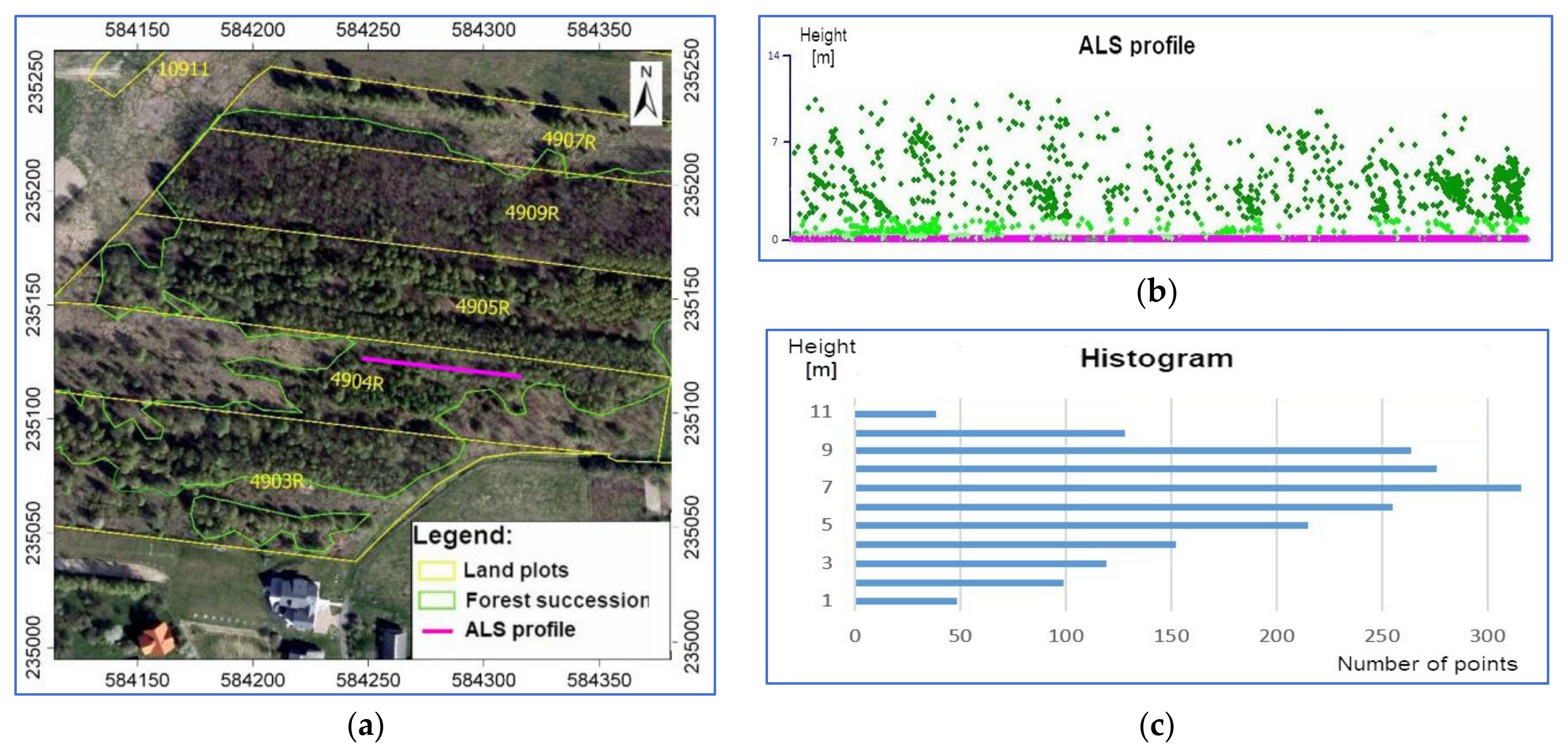
- LiDAR data—Airborne Laser Scanning (ALS) point clouds (2019), parameters: 4 reflections as a minimum, 6 points/m2, the altitude accuracy ≤ 0.15 m, situational accuracy ≤ 0.50 m.; source: IT Project—System for the Protection of Poland; Main Office of Geodesy and Cartography [19]).
- Orthophotomaps (2019, GSD: 0.25 m, coordinates system: PL-PUWG1992).
- Cadastral data (portals: WebEwid and Geoportal).
3. Results
4. Discussion
5. Conclusions
Funding
Institutional Review Board Statement
Informed Consent Statement
Acknowledgments
Conflicts of Interest
References
- Bergen, K.M.; Dronova, I. Observing succession on aspen-dominated landscapes using a remote sensing-ecosystem approach. Landsc. Ecol. 2007, 22, 1395–1410. [Google Scholar] [CrossRef]
- Bowen, M.E.; Mcalpine, C.A.; House, A.P.N.; Smith, G.C. Regrowth forests on abandoned agricultural land: A review of their habitat values for recovering forest fauna. Biol. Conserv. 2007, 140, 273–296. [Google Scholar] [CrossRef]
- Ruskule, A.; Nikodemus, O.; Kasparinska, Z.; Kasparinskis, R.; Brumelis, G. Patterns of afforestation on abandoned agriculture land in Latvia. Agrofor. Syst. 2012, 85, 215–231. [Google Scholar] [CrossRef]
- Szwagrzyk, J. Forest succession on abandoned farmland; current estimates, forecasts and uncertainties. Sylwan 2004, 4, 53–59. [Google Scholar]
- Gniadek, J.; Pijanowski, J.; Śmigielski, M. Impact of the forest succession on efficiency of the arable land production. J. Water Land Dev. 2017, 34, 131–138. [Google Scholar] [CrossRef]
- Śmigielski, M.; Pijanowski, J.; Gniadek, J. Forest succession and afforestation of agricultural land as a current challenge agricultural works. Acta Sci. Pol. Form. Circumiectus 2017, 16, 51–63. [Google Scholar] [CrossRef]
- Szostak, M.; Wężyk, P.; Tompalski, P. Aerial orthophoto and airborne laser scanning as monitoring tools for land cover dynamics: A case study from the Milicz Forest District (Poland). Pure Appl. Geophys. 2014, 171, 857–866. [Google Scholar] [CrossRef]
- Wężyk, P.; Szostak, M.; Tompalski, P. Comparison of the accuracy of the “PHOTO” check method with automatic analysis based on ALS data for direct control of subsidy payments. Arch. Photogramm. Remote Sens. 2009, 20, 445–456. [Google Scholar]
- Susyan, E.A.; Wirth, S.; Ananyeva, N.D.; Stolnikova, E.V. Forest succession on abandoned arable soils in European Russia—Impacts on microbial biomass, fungal-bacterial ratio, and basal CO2 respiration activity. Eur. J. Soil Biol. 2011, 47, 169–174. [Google Scholar] [CrossRef]
- Buraczyk, W. Structure and Breeding Value of Self-Sown Woody Species in the Initial Phase of Secondary Succession on Post-Agricultural Lands of the Lower Part of Poland; Warsaw Univesity of Life Sciences Press: Warsaw, Poland, 2013. [Google Scholar]
- Kolecka, N.; Kozak, J.; Kaim, D.; Dobosz, M.; Ginzler, C.; Psomas, A. Mapping secondary forest succession on abandoned agricultural land in the Polish Carpathians. Int. Arch. Photogramm. Remote Sens. Spat. Inf. Sci. 2016, 41, 931–935. [Google Scholar] [CrossRef]
- Lasanta, T.; Arnáez, J.; Pascual, N.; Ruiz-Flaño, P.; Errea, M.P.; Lana-Renault, N. Space–time process and drivers of land abandonment in Europe. Catena 2017, 149, 810–823. [Google Scholar] [CrossRef]
- Prishchepov, A.V.; Volker, C.R.; Dubinin, M.; Alcantara, C. The Effect of Landsat ETM/ETM + Image Acquisition Dates on the Detection of Agricultural Land Abandonment in Eastern Europe. Remote Sens. Environ. 2012, 126, 195–209. [Google Scholar] [CrossRef]
- Singh, K.; Vogler, J.; Shoemaker, D.; Meentemeyer, R. LiDAR-Landsat data fusion for large area assessment of urban land cover: Balancing spatial resolution, data volume, and mapping accuracy. J. Photogramm. Remote Sens. 2012, 74, 110–121. [Google Scholar] [CrossRef]
- Bochenek, J. Analysis of ALS point clouds to determine the spatial structure of vegetation in the areas of secondary forest succession in the Wieliczka district. Master’s Thesis, The University of Agriculture in Krakow, Krakow, Poland, 2019. [Google Scholar]
- ESA. Sentinel-2. 2022. Available online: https://sentinel.esa.int (accessed on 1 January 2022).
- Planet’s Education and Research (E&R) Program, Planet Team. Planet Application Program Interface: In Space for Life on Earth, San Francisco, CA. 2017. Available online: https://api.planet.com (accessed on 1 January 2022).
- Planet. 2022. Available online: https://www.planet.com/products/planet-imagery (accessed on 1 January 2022).
- Main Office of Geodesy and Cartography. ISOK Project. 2022. Available online: https://www.isok.gov.pl/index.html (accessed on 1 January 2022).
- Copernicus Program, ESA. 2022. Available online: https://www.copernicus.eu/pl (accessed on 1 January 2022).
- McGaughey, R.J. Fusion/ldv: Software for Lidar Data Analysis and Visualization; Software manual; USDA Forest Service, Pacific Northwest Research Station: Portland, OR, USA, 2012. [Google Scholar]
- Naesset, E. Predicting forest stand characteristics with airborne scanning laser using a practical two-stage procedure and field data. Remote Sens. Environ. 2002, 80, 80–99. [Google Scholar] [CrossRef]
- Naesset, E.; Økland, T. Estimating tree height and tree crown properties using airborne scanning laser in a boreal nature reserve. Remote Sens. Environ. 2002, 79, 105–115. [Google Scholar] [CrossRef]
- Mcgaughey, R.J.; Carson, W.; Reutebuch, S.; Andersen, H.E. Direct measurement of individual tree characteristics from lidar data. In Proceedings of the Annual ASPRS Conference, Denver, CO, USA, 23–28 May 2004. [Google Scholar]
- Sadkowski, P. Identification areas of secondary forest succession in the areas of Milicz and Biskupice commune with the use of PlanetScope satellite imagery. Master’s Thesis, The University of Agriculture in Krakow, Krakow, Poland, 2021. [Google Scholar]
- Act of Forest. In Journal of Laws; ECOLEX: Warsaw, Poland, 1991; Volume 101, p. 444.
- Act of land and building register. In Journal of Laws; Regulation of the Minister of Development, Labor and Technology: Warsaw, Poland, 2021.
- Ministry of the Environment. National Program for Increasing Woodness. In Document Adopted for Implementation by a Resolution of the Council of Ministers in June 1995; updated in 2003; Ministry of the Environment: Warsaw, Poland, 2003. [Google Scholar]
- Hościło, A.; Mirończuk, A.; Lewandowska, A. Determination of the actual forest area in Poland based on the available spatial datasets. Sylwan 2016, 160, 627–634. [Google Scholar]
- Jabłoński, M.; Mionskowski, M.; Budniak, P. Forest area in Poland based on national forest inventory. Sylwan 2018, 162, 365–372. [Google Scholar]
- Forkuor, G.; Dimobe, K.; Serme, I.; Tondoh, J.E. Landsat-8 vs. Sentinel-2: Examining the added value of Sentinel-2′s red-edge bands to land-use and land-cover mapping in Burkina Faso. GISci. Remote Sens. 2018, 55, 331–354. [Google Scholar] [CrossRef]
- Marangoz, A.M.; Sekertekin, A.; Akçin, H. Analysis of land use land cover classification results derived from Sentinel-2 image. In Proceedings of the 17th International Multidisciplinary Scientific GeoConference Surveying Geology and Mining Ecology Management, SGEM2017, Vienna, Austria, 27–29 November 2017; pp. 25–32. [Google Scholar]
- Sekertekin, A.; Marangoz, A.M.; Akcin, H. Pixel-based classification analysis of land use land cover using Sentinel-2 and Landsat-8 data. Int. Arch. Photogramm. Remote Sens. 2017, 42, 91–93. [Google Scholar] [CrossRef]
- Zhang, Z.; Dong, X.; Tian, J.; Tian, Q.; Xi, Y.; He, D. Stand density estimation based on fractional vegetation coverage from Sentinel-2 satellite imagery. Int. J. Appl. Earth Obs. Geoinf. 2022, 108, 102760. [Google Scholar] [CrossRef]
- Szostak, M.; Likus-Cieślik, J.; Pietrzykowski, M. PlanetScope Imageries and LiDAR Point Clouds Processing for Automation Land Cover Mapping and Vegetation Assessment of a Reclaimed Sulfur Mine. Remote Sens. 2021, 13, 2717. [Google Scholar] [CrossRef]
- Alberti, G.; Boscutti, F.; Pirotti, F.; Bertacco, C.; De Simon, G.; Sigura, M.; Cazorzi, F.; Bonfanti, P. A LiDAR-based approach for a multi-purpose characterization of Alpine forests: An Italian case study. iForest 2013, 6, 156–168. [Google Scholar] [CrossRef]
- Andersen, H.E.; Reutebuch, S.E.; McGaughey, R.J. A rigorous assessment of tree height measurements was obtained using airborne lidar and conventional field methods. Can. J. Remote Sens. 2006, 32, 355–366. [Google Scholar] [CrossRef]
- Bork, E.; Su, J. Integrating LIDAR data and multispectral imagery for enhanced classification of rangeland vegetation: A meta-analysis. Remote Sens. Environ. 2007, 111, 11–24. [Google Scholar] [CrossRef]
- Falkowski, M.J.; Evans, J.S.; Martinuzzi, S.; Gessler, P.E.; Hudak, A.T. Characterizing forest succession with lidar data: An evaluation for the Inland Northwest, USA. Remote Sens. Environ. 2009, 113, 946–956. [Google Scholar] [CrossRef]
- Hyyppä, J.; Hyyppä, H.; Litkey, P.; Yu, X.; Haggrén, H.; Rönnholm, P.; Pyysalo, U.; Pitkanen, J.; Maltamo, M. Algorithms and methods of airborne laser-scanning for forest measurements. Int. Arch. Photogramm. Remote Sens. Spat. Inf. Sci. 2004, 36, 82–89. [Google Scholar]
- Kolecka, N.; Kozak, J.; Kaim, D.; Dobosz, M.; Ginzler, C.; Psomas, A. Mapping secondary forest succession on abandoned agricultural land with LiDAR point clouds and terrestrial photography. Remote Sens. 2015, 7, 8300–8322. [Google Scholar] [CrossRef]
- Kolecka, N. Height of Successional Vegetation Indicates Moment of Agricultural Land Abandonment. Remote Sens. 2018, 10, 1568. [Google Scholar] [CrossRef]
- Maier, B.; Tiede, D.; Dorren, L. Characterising mountain forest structure using landscape metrics on LIDAR-based canopy surface models. In Object-Based Image Analysis; Springer: Berlin/Heidelberg, Germany, 2008; pp. 625–643. [Google Scholar] [CrossRef]
- Maltamo, M.; Mustonen, K.; Hyyppa, J.; Pitkanen, J.; Yu, X. The accuracy of estimating individual tree variables with airborne laser scanning in a boreal nature reserve. Can. J. For. Res. 2004, 34, 1791–1801. [Google Scholar] [CrossRef]
- Szostak, M. Automated land cover change detection and forest succession monitoring using LiDAR Point Clouds and GIS analyses. Geosciences 2020, 10, 321. [Google Scholar] [CrossRef]
- Koska, B.; Jirkab, V.; Urbana, R.; Kremena, T.; Hesslerovab, P.; Jona, J.; Pospisila, J.; Fogl, M. Suitability, characteristics, and comparison of an airship UAV with lidar for middle size area mapping. Int. J. Remote Sens. 2017, 38, 2973–2990. [Google Scholar] [CrossRef]
- Moudrý, V.; Gdulová, K.; Fogl, M.; Klápště, P.; Urban, R.; Komárek, J.; Moudrá, L.; Štroner, M.; Barták, V.; Solský, M. Comparison of leaf-off and leaf-on combined UAV imagery and airborne LiDAR for assessment of a post-mining site terrain and vegetation structure: Prospects for monitoring hazards and restoration success. Appl. Geogr. 2019, 104, 32–41. [Google Scholar] [CrossRef]
- Osińska-Skotak, K.; Jełowiecki, Ł.; Bakuła, K.; Michalska-Hejduk, D.; Wylazłowska, J.; Kopeć, D. Analysis of using dense image matching techniques to study the process of secondary succession in non-forest natura 2000 habitats. Remote Sens. 2019, 11, 893. [Google Scholar] [CrossRef]
- Ostrowski, W.; Górski, K.; Pilarska, M.; Salach, A.; Bakuła, K. Comparison of the laser scanning solutions for the unmanned aerial vehicles. Arch. Photogramm. Cartogr. Remote Sens. 2017, 29, 101–123. [Google Scholar] [CrossRef]
- Urban, R.; Koska, B.; Moudry, V.; Solsky, M. Terrain of post mining site from airship lidar. In Proceedings of the 16th International Multidisciplinary Scientific GeoConference, SGEM2016, Albena, Bulgaria, 30 June–6 July 2016; Volume 2, pp. 577–584. [Google Scholar] [CrossRef]
- White, J.; Stepper, C.; Tompalski, P.; Coops, N.; Wulder, M. Comparing ALS and Image-Based Point Cloud Metrics and Modelled Forest Inventory Attributes in Complex Coastal Forest Environment. Forests 2015, 6, 3704–3732. [Google Scholar] [CrossRef]
- White, J.; Wulder, M.; Vastaranta, M.; Coops, N.; Pitt, D.; Woods, M. The Utility of Image-Based Point Clouds for Forest Inventory: A Comparison with Airborne Laser Scanning. Forests 2013, 4, 518–536. [Google Scholar] [CrossRef]
- Tymińska-Czabańska, L.; Hawryło, P.; Socha, J. Assessment of the effect of stand density on the height growth of Scots pine using repeated ALS data. Int. J. Appl. Earth Obs. Geoinf. 2022, 108, 102763. [Google Scholar] [CrossRef]
- Ai, J.; Zhang, C.; Chen, L.; Li, D. Mapping annual land use and land cover changes in the Yangtze estuary region using an object-based classification framework and Landsat time series data. Sustainability 2020, 12, 659. [Google Scholar] [CrossRef]
- Sackov, I.; Barka, I.; Bucha, T. Mapping Aboveground Woody Biomass on Abandoned Agricultural Land Based on Airborne Laser Scanning Data. Remote Sens. 2020, 12, 4189. [Google Scholar] [CrossRef]
- Verstegen, J.; der Laan, C.; Dekkerb, S.; Faaij, A.; Santos, M. Recent and projected impacts of land use and land cover changes on carbon stocks and biodiversity in East Kalimantan, Indonesia. Ecol. Indic. 2019, 103, 563–575. [Google Scholar] [CrossRef]


| LULC Classes | Cadastral Data | PlanetScope | Sentinel-2 | Ortho | ALS |
|---|---|---|---|---|---|
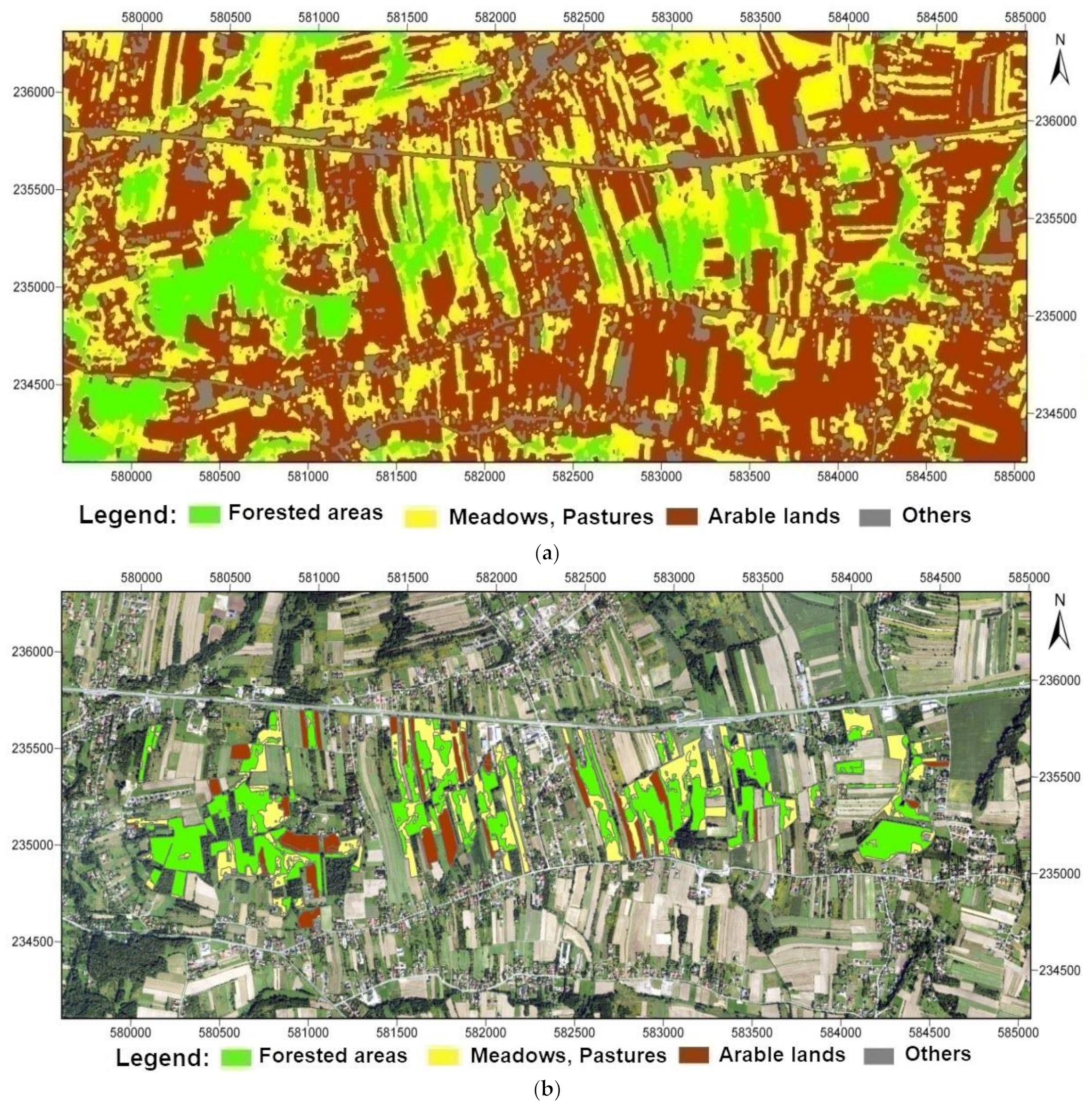
| Forested areas | 10.76 ha 7.70% | 62.77 ha 44.91% | 65.08 ha 46.56% | 56.32 ha 41.73% | 60.64 ha 43.39% |
| Meadows, Pastures | 101.38 ha 72.53% | 57.69 ha 41.27% | 56.75 ha 40.60% | ||
| Arable lands | 26.39 ha 18.88% | 18.37 ha 13.14% | 16.52 ha 11.82% | ||
| Others | 1.24 ha 0.89% | 0.94 ha 0.67% | 1.42 ha 1.02% | ||
| Total | 139.77 ha (100.00%) | ||||
| Land Cover Classes (LULC) | Forested areas | Meadows Pastures | Arable lands | Others | Total | User Accuracy [%] |
|---|---|---|---|---|---|---|
| Forested Areas | 76 | 1 | 0 | 0 | 77 | 98.70 |
| Meadows, Pastures | 3 | 150 | 2 | 0 | 155 | 96.77 |
| Arable Lands | 0 | 6 | 226 | 3 | 235 | 96.17 |
| Others | 0 | 2 | 1 | 30 | 33 | 90.91 |
| Total | 79 | 159 | 229 | 33 | 500 | 95.64 |
| Producer Accuracy [%] | 96.20 | 94.34 | 98.69 | 90.91 | 95.04 | OA = 96.40 Kappa = 94.52 |
Publisher’s Note: MDPI stays neutral with regard to jurisdictional claims in published maps and institutional affiliations. |
© 2022 by the author. Licensee MDPI, Basel, Switzerland. This article is an open access article distributed under the terms and conditions of the Creative Commons Attribution (CC BY) license (https://creativecommons.org/licenses/by/4.0/).
Share and Cite
Szostak, M. Usage PlanetScope Images and LiDAR Point Clouds for Characterizing the Forest Succession Process in Post-Agricultural Areas. Sustainability 2022, 14, 14110. https://doi.org/10.3390/su142114110
Szostak M. Usage PlanetScope Images and LiDAR Point Clouds for Characterizing the Forest Succession Process in Post-Agricultural Areas. Sustainability. 2022; 14(21):14110. https://doi.org/10.3390/su142114110
Chicago/Turabian StyleSzostak, Marta. 2022. "Usage PlanetScope Images and LiDAR Point Clouds for Characterizing the Forest Succession Process in Post-Agricultural Areas" Sustainability 14, no. 21: 14110. https://doi.org/10.3390/su142114110
APA StyleSzostak, M. (2022). Usage PlanetScope Images and LiDAR Point Clouds for Characterizing the Forest Succession Process in Post-Agricultural Areas. Sustainability, 14(21), 14110. https://doi.org/10.3390/su142114110


