Article

Spatial Pattern Reconstruction of Water and Land Resources in Coal Mining Subsidence Areas within Urban Regions

1
Anhui Province Engineering Laboratory for Mine Ecological Remediation, Anhui University, Hefei 230601, China
2
Huaibei Bureau of Natural Resources and Planning, Huaibei 235000, China
3
Anhui Construction Engineering Group Corporation Limited, Hefei 230031, China
4
Department of Engineering Management, Hefei College of Finance and Economics, Hefei 231299, China
*
Author to whom correspondence should be addressed.
Sustainability 2022, 14(18), 11397; https://doi.org/10.3390/su141811397
Submission received: 5 August 2022 / Revised: 6 September 2022 / Accepted: 8 September 2022 / Published: 11 September 2022

Abstract

:
Water and land resources are important material bases of economic and social development, and their spatial patterns determine the pattern of the urban development. The development and expansion of coal-resource-based cities have introduced new societal problems, such as the overlapping of new city construction areas and underground coal resources. Underground coal mining also leads to surface subsidence, which destroys water and land resources and seriously affects the sustainable development of coal-resource-based cities. The surface subsidence area takes a long time to stabilize, and may form a large waterlogging area due to the high groundwater level, thereby increasing the difficulty of reconstructing mining subsidence areas. In this context, a scientific and complete method for reconstructing the spatial pattern of water and land resources in unstable coal mining subsidence areas within urban is proposed in this paper. This method initially predicts the surface subsidence value and then divides the subsidence area within the urban region into the waterlogging area and the non-waterlogging area according to the surface subsidence value. The waterlogging area will be renovated into a landscape lake district in the city by a series of transformation measures. Afterwards, goaf rock mass activation and surface stability evaluation analyses are performed in the non-waterlogging area. According to the evaluation results, land resources can be divided into unaffected, restricted and prohibited building areas, with each area being transformed differently. The Lv Jin Lake in Huaibei is selected as a case study, and the proposed method is applied to reconstruct its water and land resources. The original spatial pattern of the large-scale waterlogging area and abandoned land due to mining subsidence in urban areas is then reconstructed into a spatial pattern that integrates the urban landscape, scenario living and eco-tourism. Compared with traditional subsidence area management, the proposed method greatly increases the utilization value of water and land resources, improves the urban ecological environment, enhances the urban quality and effectively alleviates the problems of land shortage and human–land conflict in coal-resource-based cities.

1. Introduction

Coal is a main energy resource in the world that supports sustained and stable economic development. However, the dependence on this resource has also introduced a series of environmental problems [1,2]. After underground coal is excavated, the surrounding rock mass loses its original stress balance state, and stress redistribution creates stress concentration [3,4]. When the concentrated stress on the roof of the roadway exceeds the strength limit, the roof rock produces deformation, cracks and falls, and causes the overburden stratum to produce compaction and consolidation subsidence. This eventually leads to the movement and deformation of the entire overlying strata, and subsidence basin formed on the surface [5,6,7,8,9,10]. Many negative environmental impacts are caused by long-term high intensity and large-scale coal mining activities, including surface subsidence, ground fissures, landslides and land encroachment [11,12,13,14]. Statistics show that every 1000 tons of coal mining in China causes approximately 0.2 to 0.33 hectares of land subsidence and expands the subsidence area by approximately 7 × 10⁴ hectares every year [15]. Coal mining subsidence areas have been recorded in 151 counties of 23 provinces across China [16]. The total coal mining subsidence area in the country has exceeded 2.0 × 10⁶ hectares, whilst that of some coal-resource-based cities has already exceeded 10% of the total urban area [17].
Subsidence areas with high groundwater levels can easily suffer from waterlogging [18]. When the subsidence basin exceeds the height of groundwater to form a waterlogging area, the groundwater begins to flow into the subsidence basin, and the subsidence basin begins to accumulate water [19]. The subsidence waterlogging expands along with the subsidence basin [20]. When the input and output water volumes reach a balanced state, the range of the waterlogging area remains unchanged in the subsidence basin as shown in Figure 1. The Huainan and Huaibei mining areas in Anhui Province are amongst the 14 largest coal bases in China, characterized by deep burial, thick coal seams and high groundwater levels [21]. On the one hand, these mining areas are located in temperate and humid climates, with annual precipitations ranging between 800 mm and 900 mm [16]. On the other hand, the underground water depths in these areas are less than 5 m [22]. Groundwater porous flow forms the waterlogging area when the surface subsidence exceeds the height of underground water and the high groundwater level and abundant precipitation altogether lead to large-scale waterlogging in the subsidence basin [23]. Statistics show that the subsidence area in Huainan had reached 3.5 × 10⁴ hectares in 2020, of which the waterlogging area accounted for 2.6 × 10⁴ hectares. The total subsidence area will reach 6.78 × 10⁴ hectares, and the waterlogging area will reach 5.0 × 10⁴ hectares [16]. Many instances of subsidence waterlogging due to underground coal mining have also been reported around the world. For instance, the Berkeley Pit Lake in Montana, US [24], the Pontes in Spain [25] and the Raigarh District in India [26] are all affected by coal mining subsidence, hence reaffirming the status of coal mining subsidence as a global geological disaster [16].
Large-scale subsidence areas are caused by coal mining activities and form waterlogging areas [18]. A large amount of subsidence water can destroy land resources and consequently hinder farming activities [27] (Figure 2). Scientific studies have proposed comprehensive technologies for treating coal mining subsidence areas [28,29]. The Pan’an Lake in Xuzhou City, Jiangsu Province in China presents a successful case of coal mining subsidence area treatment [30,31]. The traditional method for coal mining subsidence treatment mainly aims towards reconstructing these areas into cultivated lands, but the land reclamation rate only ranges from 15% to 25% [32]. In addition, these methods consume much time and have a mediocre governance effect. Hu proposed the concurrent mining and reclamation method, which realizes concurrent mining and reclamation through reasonable reclamation measures to reduce land damage, and preferred reclamation opportunities and schemes before or during the subsidence [28,33]. This method leverages a full combination of mining and reclamation technologies, ensures synchronization with the mining program, improves the land restoration rate, shortens the reclamation cycle and increases the reclamation benefits [34,35]. After a series of treatment measures, the damaged land resources can be used again. However, the broken spatial patterns of coal-resource-based cities cannot be solved properly using the traditional subsidence area treatment methods.
Underground coal mining has a very significant impact on coal-resource-based cities [36]. With the continuous development and expansion of cities, their construction areas begin to overlap with underground coal resources [37]. Coal-resource-based cities have a complex and changeable spatial pattern with certain regional particularity [38]. The urban spatial pattern is a direct representation of urban development and serves as the carrier of economic activities. Therefore, any change in the urban spatial pattern affects the process of urban development [39]. Coal mining brings a series of environmental and social problems, including water pollution, environmental degradation, land shortage, population loss and human–land conflict, in coal-resource-based cities. This activity can also lead to a fragmented and patchy urban spatial pattern and affects the sustainable development of coal-resource-based cities [40,41,42]. Many coal-resource-based cities are affected by coal mining subsidence in China [36]. For instance, Xintai in Shandong Province is a typical coal-resource-exhausted city whose land and water resources have been completely destroyed due to long-term intensive mining activities. Therefore, the spatial pattern of water and land resources has become a bottleneck that restricts urban development [43,44,45].
Large land subsidence and waterlogging areas can transform the original terrestrial ecosystem into an aquatic–terrestrial complex ecosystem [16]. The spatial pattern of coal-resource-based cities has changed significantly. In addition, the traditional methods for treating coal mining subsidence, such as the reclamation of subsidence areas into farmlands, woodlands and fishponds, cannot address the human–land conflict [36,44,45]. Reducing the time of land abandonment and rationally planning the spatial pattern based on the cross-complexity in the space of unstable coal mining subsidence areas within urban areas and the high added-value of land have become crucial issues that need to be addressed to achieve successful reclamation in coal-resource-based cities. To address these problems, this paper proposes a set of methods for the spatial pattern reconstruction of water and land resources in unstable coal mining subsidence areas within urban regions. The Lv Jin Lake mining subsidence area in Huaibei, Anhui Province is selected as a case study. The following research questions are proposed: (1) how can the changed water and land resources be reasonably planned according to the needs of urban development and the stability of the non-waterlogging and waterlogging areas caused by underground mining? (2) How can the reconstruction of water and land resources in coal mining subsidence areas within urban spaces greatly shorten the abandonment time of these resources?
The rest of this paper is organized as follows. Section 2 briefly describes the proposed spatial pattern reconstruction method and the reconstruction of water and land resources in waterlogging and non-waterlogging areas. Section 3 presents an engineering case of the spatial pattern reconstruction method. Section 4 highlights the benefits of coal mining subsidence area treatment to the economy, ecology and society. Section 5 concludes the paper.

2. Spatial Pattern Reconstruction Method of Water and Land Resources in Unstable Coal Mining Subsidence Area within Urban Regions

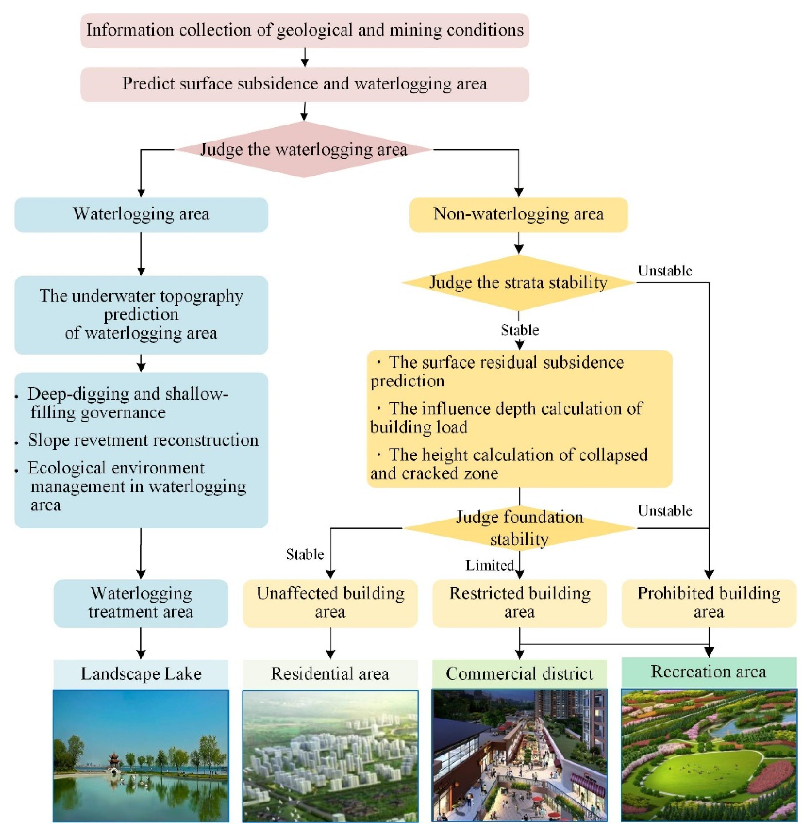
2.1. A Brief Description of the Spatial Pattern Reconstruction Method

The development and expansion of coal-resource-based cities can lead to an overlap between new city construction areas and underground coal resources. Underground coal mining results in surface subsidence, which in turn leads to houses collapsing, road subsidence, bridge fractures and the deterioration of cultivated land and water. Surface subsidence in urban areas destroys water and land resources, thereby seriously affecting urban sustainable development and the stability of the urban ecosystem. The abandonment of land and water resources, disturbance of the ecological system and deterioration of human settlements in coal mining subsidence areas within urban spaces are the three major factors that restrict the construction of coal-resource-based cities. Figure 3 illustrates the proposed method for reconstructing the spatial pattern of water and land resources in unstable coal mining subsidence areas within urban regions. Specifically, this method aims to reconstruct the waterlogging and abandoned land in urban areas into a spatial pattern that integrates the urban landscape, scenario living and eco-tourism. In this way, human–land conflicts can be effectively addressed, and a coordinated development amongst the society, economy and nature can be promoted. This method also effectively improves the ecological environment and promotes the rapid and sustainable development of regional economies in coal mining subsidence areas within urban areas. The flow of this method is described as follows:
(1)
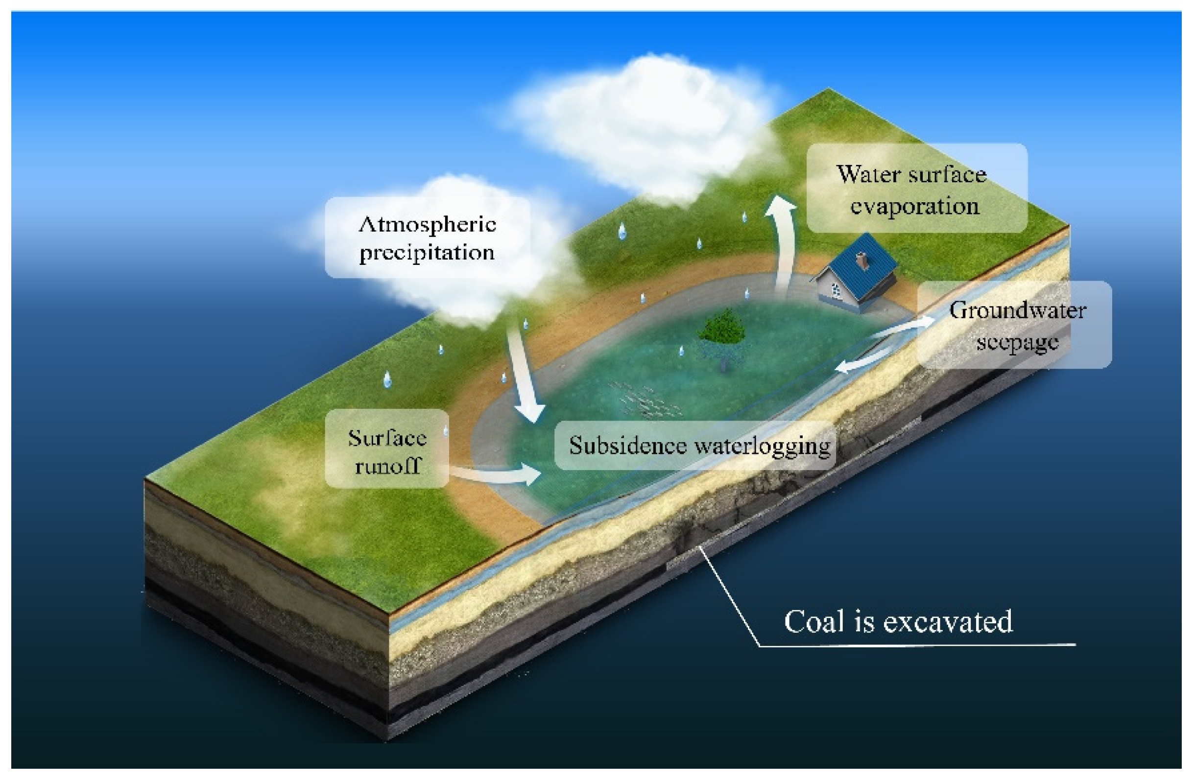
Data on the geological and mining conditions of the subsidence areas are initially collected, including their strata composition, geological structure, hydrogeological data and coal mining data. The final subsidence values are then predicted based on the collected data, the probability integration method and the subsidence prediction parameters. The subsidence values, groundwater level elevation and precipitation are combined to analyze the distribution of subsidence waterlogging. Afterwards, the subsidence areas within urban regions are divided into waterlogging and non-waterlogging areas.
(2)
The scope of subsidence waterlogging and the underwater bottom topography of the waterlogging area are predicted. This area will be renovated into a landscape lake district in the city by a series of transformation measures, including deep-excavation and shallow-filling governance, slope revetment reconstruction and ecological environment management.
(3)
The stability of the overlying strata in the goaf of the non-waterlogging area is analyzed based on the structure and damage of the overlying strata above the goaf. The ground areas above the goaf are divided into stable and unstable areas. The unstable area is transformed into an urban green space, whereas the stable area is further analyzed as a construction area.
(4)
The surface residual subsidence values at the stable area above the goaf are predicted. If the surface subsidence is large and exceeds the subsidence limit, then this area will be designated as the prohibited building area or restricted construction area until the surface subsidence becomes stabilized after a few years. The remaining area within the subsidence limit needs to be further evaluated for the foundation stability of the construction buildings so as to determine the allowable height of buildings. The sum of the height of the fracture zone and caving zone and the influence depth of the building load are then calculated. If the calculated value is less than the coal mining depth, then the building height has no restriction. Otherwise, the design height of the building is reduced until the foundation stability requirements of the construction buildings are met. This area will also be designated as the restricted construction area. If the foundation stability requirements cannot be met, then this area will be designated as the prohibited building area.
(5)
According to the foundation stability of the surface buildings, the land resources of the non-waterlogging area are divided into unaffected, restricted and prohibited building areas, which are transformed differently as follows:
  • The unaffected building areas are reasonably planned as the residential and commercial areas to solve the contradiction between the expansion of the subsidence area and the rapid growth of residential land resources for construction and to improve the value of land use.
  • Although the buildings in the restricted construction area are affected by mining subsidence, the impact is relatively small, and residential areas and large shopping malls with low floors can be built.
  • The prohibited building area can be designed as part of a wetland park to maintain and improve the surrounding ecological environment. In this area, urban green spaces can be built, and sports and entertainment facilities can be constructed to provide recreational places for the surrounding residents.

2.2. Reconstruction of Water and Land Resources in the Waterlogging Area

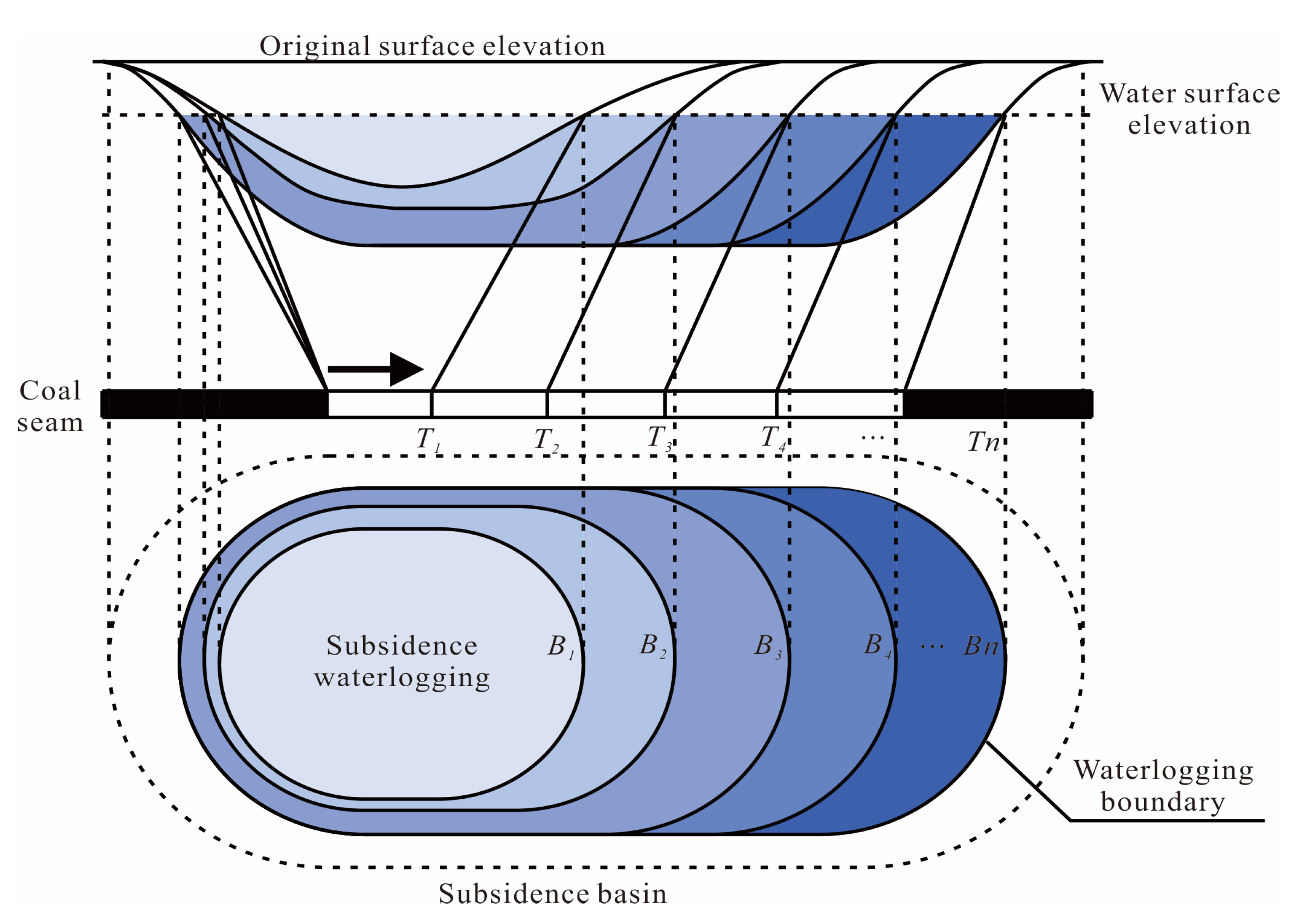
2.2.1. Surface Subsidence Prediction

Surface subsidence prediction is one of the most important steps in the proposed spatial pattern reconstruction method, and its accuracy directly affects the area of water and land resources reconstruction and the early-stage stability assessment of building construction.
The probability integral method (PIM) is a mining subsidence prediction method based on stochastic medium theory. This theory was introduced to strata movement research by J. Litwiniszyn in the 1950s [46], and it was later developed by Chinese scholars Liu Baochen and Liao Guohua et al. into the probability integral method [47]. In China, the PIM is the most used function for coal mine subsidence prediction and plays an important role in reducing the loss of mining subsidence. The strata are regarded as continuous media in the PIM, the movement of the strata and surface is regarded as granular media for the stochastic medium and the granular media move down randomly under the action of gravity (Figure 4). The most important step in the PIM is to obtain the prediction parameters accurately; as this method has been in use in China for a long time, scholars have already summarized the prediction parameters for most coal mines in the country, and these parameters are stated in regulations for easy reference [48]. In engineering applications, apart from accuracy, the convenience and implementability of the prediction method also need to be considered. The PIM is a mature method with only a few prediction parameters. According to the principles of mining subsidence prediction for the PIM, the surface subsidence caused by a small unit can be computed as:
W e x , y = 1 r e π x 2 + y 2 r 2 ,
where W e x , y is the surface subsidence caused by small unit mining, (x, y) are the coordinates of the surface point, r is the major influence radius given by r = H/tanβ, H is the mining depth and tanβ is the tangent of the major influence angle.
The integral is carried out on the whole working face, and the subsidence value of any point caused by the mining of the working face can be calculated as:
W x , y = D W 0 W e ( x , y ) d s d t = D W 0 r 2 e π ( x s ) 2 + ( y t ) 2 r 2 d s d t ,
where W ( x , y ) is the subsidence of working face mining; W 0 is the maximum ground subsidence, W 0 = m q cos α ; m is the mining thickness; q is the subsidence factor; α is the dip angle of the coal seam; D is the calculation mining area of the working face; the length of the area along the strike is D3; l is the calculated length of the working face along the strike, which can be calculated by l = D32S; S is the inflection point offset; the length of the area D along inclination is D1; L is the calculated length of the working face along the dip, which can be calculated by L = ( D 1 2 S ) sin ( θ + α ) sin ( θ ) ; θ is the main propagation angle; dsdt is the integration variable of the double integral of area D.
The scope change of the subsidence area caused by underground coal mining is a dynamic process with the advancement of the working face. The surface subsidence gradually develops to the strike direction of the working face. A large-scale waterlogging area forms in the mining area with a high groundwater level, and the subsidence accumulation of water is also a dynamic process. The waterlogging area gradually expands with the advancement of the working face. Therefore, to utilize water and land resources in unstable coal mining subsidence areas comprehensively, predicting the waterlogging area’s scope is important. As shown in Figure 5, when the working face is advanced to different positions (T1, T2, T3, … Tn), the range of the subsidence basin and the position of the waterlogging area boundary are different (B1, B2, B3, … Bn).
The Knothe time function is introduced to dynamically predict the subsidence of the working face advancing to different positions [49]. This function was introduced by Polish scholar Knothe [50], who proposed that the sinking speed of a point on the surface at time t is proportional to the difference between the final subsidence of this point and the subsidence at time t. By combining the Knothe time function with the PIM, the progressive surface subsidence can be computed as [51]:
W x , t = w 0 v 0 1 1 r e π x v τ 2 r 2 1 e c t τ d τ , t L v w 0 v 0 L v 1 r e π x v τ 2 r 2 1 e c t τ d τ , t L v
where v is the advance rate, and L is the mining length of the working face.

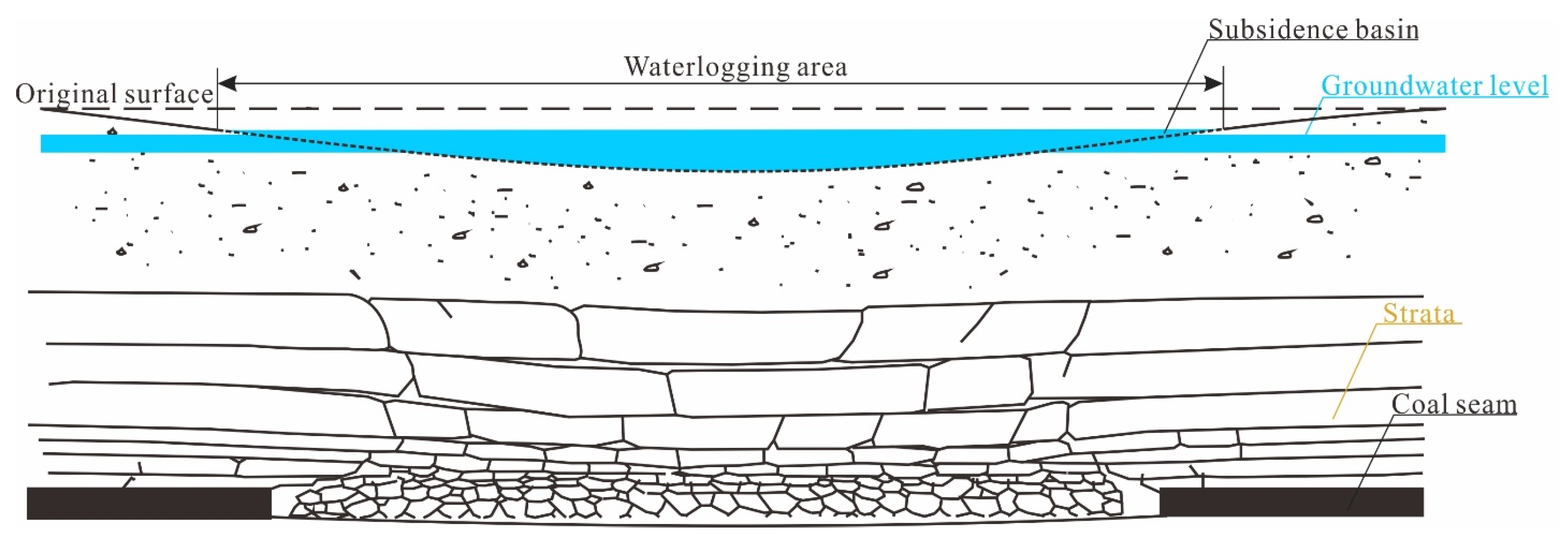
2.2.2. Waterlogging Area Prediction

The predicted surface subsidence, groundwater level and precipitation are used to predict the waterlogging area. A high groundwater level area can easily produce a large waterlogging area. After a coal mining activity is completed, the surface gradually becomes relatively stable. Despite not reaching a stable state of subsidence, the range of the waterlogging area does not significantly fluctuate. This range can be determined based on the precipitation and topographic contours of subsidence areas (Figure 6). The area of subsidence waterlogging can be computed as:
A w = 1 2 i = 1 n x i w y i + 1 w x i + 1 w y i w ,
where A w is the area of waterlogging, and ( x i w , y i w ) are the coordinates of any point in the waterlogging area.
Waterlogging in coal mining subsidence areas is a type of abundant water resource. However, the shape of the waterlogging area is irregular, and the underwater bottom topography is complex, thereby introducing problems in planning and utilizing subsidence waterlogging in advance. Therefore, the underwater bottom topography is predicted based on the predicted surface subsidence. The elevation of the subsidence basin is calculated by subtracting the surface subsidence from the original surface elevation. The underwater bottom topography of the subsidence waterlogging area can then be drawn as:
h = H w H ( x , y )
where h is the water depth at any position, H ( x , y ) is the elevation in this point after mining and H w is the elevation of the water surface.

2.2.3. Terrain Modification and Reconstruction of the Subsidence Waterlogging Area

On the basis of the obtained underwater bottom topography of the subsidence waterlogging area, the waterlogging area will be renovated into a landscape lake district in the city by a series of transformation measures, including deep-excavation and shallow-filling governance, slope revetment reconstruction and ecological environment management.
The basic rules of earthwork balance and ecological benefit maximization are followed according to the surface subsidence value and the designed terrain of the waterlogging area for designing the terrain of the future subsidence waterlogging area. Terrain modification and reconstruction are carried out before the mining of the working face or the stable subsidence of the surface [16]. The deep-excavation and shallow-filling method excavates the middle of the surface subsidence basin and fills in the edge of the surface subsidence basin after the excavation of the underground coal working face is completed or when the surface becomes stable. This method turns the waterlogging area into a landscape lake. The surface terrain is then transformed into the final terrain design as shown in Figure 7. The deep-excavation and shallow-filling area is divided into four parts. Area I is located near the boundary of the surface subsidence basin from the subsidence boundary (W(x) = 0, H1(x) = H0(x)) to the upper boundary of the surface slope after treatment (H2(x) = H0(x)). Area II is situated in the slope area subjected to tensile deformation from the upper boundary of the surface slope after treatment to the boundary of ‘deep-excavation and shallow-filling’ (H1(x) = 0). Area III is located in the slope area subjected to compression deformation from the boundary line of ‘deep-excavation and shallow-filling’ to the lower boundary of the surface slope after treatment (where W(x) is the maximum subsidence value). After the coal mining subsidence surface stabilizes, the terrains of Areas II and III become a design slope, and slope revetment reconstruction is then carried out. Area IV is located at the bottom of the subsidence basin after treatment. The mathematical model of the terrain reconstruction partition reconstruction is shown in Table 1. The terrain modification of the subsidence waterlogging area serves as the basis for the subsequent ecological environment reconstruction.
Where r is the major influence radius; s1 and s2 are the inflection point offsets; l is the calculated length of the working face along the strike; L is the calculated length of the working face along the dip; Wmax is the maximum subsidence value; k is the slope of the design slope equation; b is the intercept of the designed slope equation; H0(x) is the original surface elevation; H1(x) is the fill design elevation; and H2(x) is the treated surface elevation.
The terrain after different transformations is divided into several areas. The flat land is used to plant flowers and plants to beautify the environment, the slope land is used to fix the soil by vegetation and the subsidence waterlogging area is planted with aquatic plants to purify the aquatic environment.

2.3. Reconstruction of Land Resources in the Non-Waterlogging Area

The traditional method of land reclamation is to reclaim the land in the non-waterlogging subsidence area and then plant crops. However, land resources are very precious due to the coal mining subsidence area in the city. If these land resources are abandoned, then much usable value will be lost. To improve the land use value, this paper proposes the construction of buildings in the subsidence area in the city, and a stability assessment must be carried out before construction to ensure the safety of the buildings during use. The stability assessment of the non-waterlogging subsidence area involves an activation analysis of the rock mass in goaf, a surface residual subsidence analysis and an influence depth analysis of the ground building load. The activation of the goaf has a great influence on the rock mass deformation process, which increases the subsidence of the terrain surface. The rock mass activation analysis determines whether the strata are stable after the mining and confirms whether the subsidence of the terrain surface will increase again so as to prevent building-related disasters in the future. The surface may retain a small residual deformation for a long time after the coal seam mining is completed, and the negative effects of these small deformations on the ground buildings should be evaluated. Given that the coal mining subsidence area is located in the city, new buildings may be built. When new buildings are built on the ground, their self-weight stress acts on the top of the goaf. The gravity will be transferred to the underground soil, sand and rock in the formation, thereby affecting the underground rock mass that tends to stabilize, destroying the stable structure and increasing subsidence on the surface. The feasibility of building and the allowable building height are determined by analyzing the influence depth of additional loads and the height of the collapsed zone and cracked zone. Therefore, the stability assessment should be based on the activation analysis of the rock mass in goaf, the surface residual subsidence analysis and the influence depth analysis of the ground building load. The surface areas above the goaf are divided into stable and unstable areas. The unstable area above the goaf is transformed into an urban green space, whereas the stable area is further analyzed as a construction area.

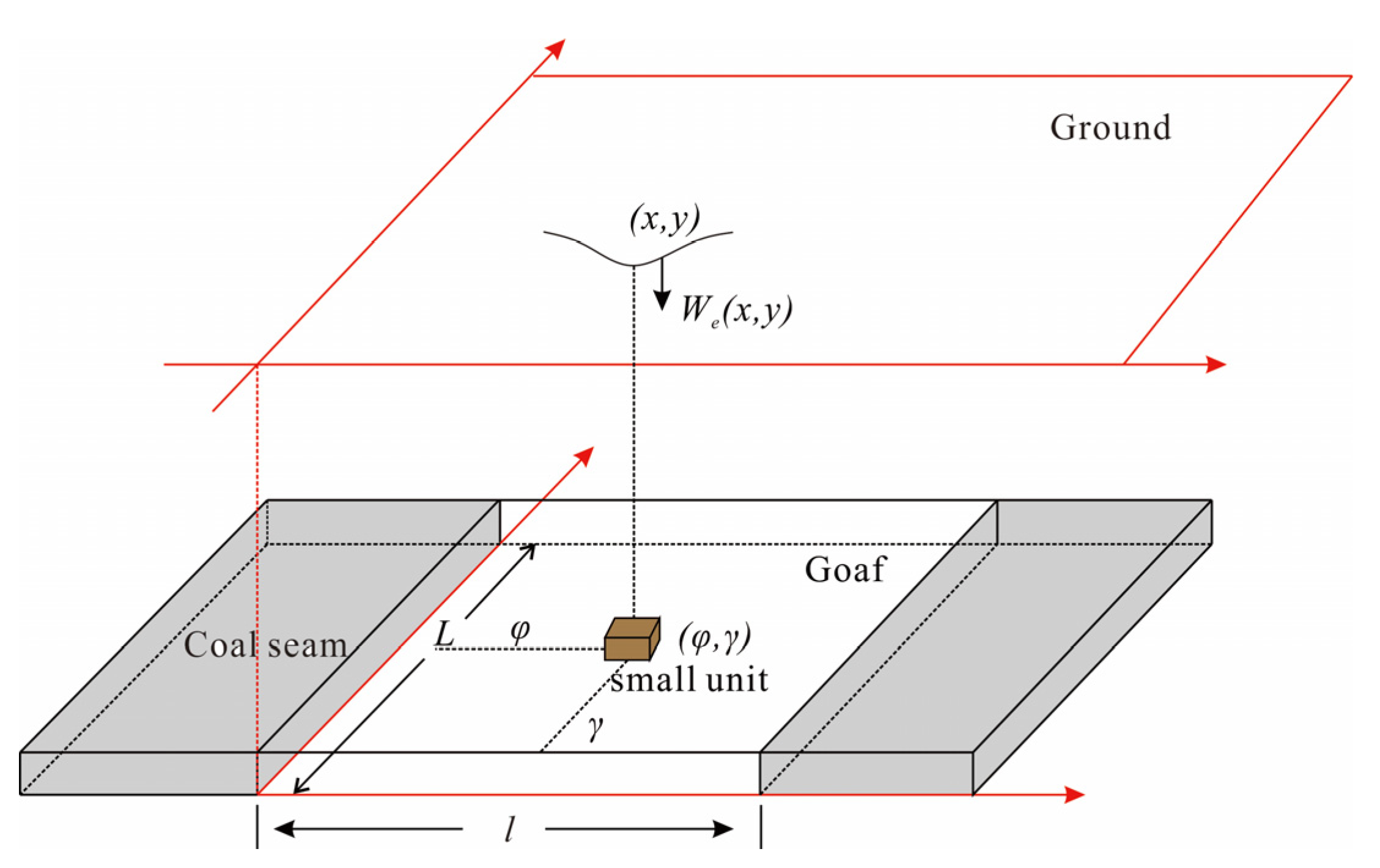
2.3.1. Activation Analysis of the Rock Mass in Goaf

After mining, some cavities at the edge of the goaf are not completely filled by the collapsed rock. As long as no new mining activities are conducted in and nearby the goaf, the activation deformation of the goaf is small, and the subsidence process on the ground surface is slow. A limited uneven subsidence can also be observed, and no severe structural instability type of subsidence failure is expected.

2.3.2. The Surface Residual Subsidence Prediction

Residual subsidence in the coal mining subsidence area affects the safety of surface buildings. New buildings in the area without subsidence waterlogging need to predict the surface residual subsidence. The PIM is mainly used to predict the subsidence and calculate the residual subsidence of coal mining subsidence, combining subsidence prediction parameters of the PIM. The regression analysis of subsidence parameters and time establishes the relationship model between the residual subsidence coefficient and the subsidence coefficient and time. The residual subsidence coefficient q r is as follows:
q r = 1 q k 1 e 1 t 50 ,
where q is the subsidence coefficient; k is the adjustment coefficient; the value is 0.5–1.0; and t is the time from the end of mining. The unit is by year.
The measured data and the calculated residual subsidence coefficient are used to predict residual subsidence. According to the regulation [48], determining the damage (protection) grade standard for brick-concrete buildings, whose length or length in the joint deformation section is less than 20 m is possible. A building’s Grade I damage standard is: inclination deformation less than 3.0 mm/m, horizontal deformation less than 2.0 mm/m and curvature deformation less than 0.2 mm/m2.

2.3.3. The Influence Depth Calculation of Ground Building Load

The stability of the subsidence area is evaluated based on whether the residual deformation of the surface is singular, and the residual deformation is predicted by solely considering the degree of deformation of the surface over time without additional stress. When a new building is built on the ground, the gravity of this building acts above the goaf, and the compression of the surface by gravity will be transmitted to the ground through the soil, sand and rock in the strata. The gravity of the building affects the original stable strata. The stable structure is broken down again, and the surface has a new deformation. The load size and position of surface buildings are the main factors that disturb the stability of the foundation. Therefore, the influence depth of the building load on the foundation and height of the crack zone and the caving zone formed above the goaf should be calculated. A comprehensive analysis of the relationship between the height of the belt and the foundation stability of the subsidence area must also be performed.
According to the evaluation method of foundation stability in the subsidence area in the regulation [48], the influence depth of the ground building load is mainly determined by the additional stress generated by the building load and the foundation’s self-weight stress. For the coal mining subsidence area, generally, when the additional stress in the foundation is equal to 10% of the self-weight stress of the corresponding position, the influence of the building load at this depth can be ignored. To consider the complexity of the activation of the damaged rock foundation in the goaf and the self-compacting effect of the deep-excavation and shallow-filling soil for safety reasons, the additional stress in the foundation is equal to 5% of the self-weight stress as the criterion for the negligible influence of the additional stress on the activated deformation of the rock mass caused by mining.
The calculation formula for the self-weight stress in the foundation is the following:
σ c = i = 1 n r i h i ,
where σ c is the self-weight stress, kPa; n is the number of soil layers from the ground to the depth z; ri is the soil bulk density, kN/m3; and hi is the thickness of soil layer, m.
The formula for calculating the additional stress at the depth z under the center point of the rectangular vertical uniform load is as follows:
σ z = 2 p π 2 m n 1 + n 2 + 8 m 2 1 + n 2 + 4 m 2 1 + 4 m 2 n 2 + 4 m 2 + arctan n 2 m 1 + n 2 + 4 m 2 = α 0 p m = l b . . . . . m = l b
where α 0 is the distribution coefficient of vertical stress below the center point under rectangular vertical uniform load; P is the uniform load, kPa; b is the width of the rectangular base, m; l is the length of the rectangular base, m; and z is the calculation point depth, m.

2.3.4. The Height Calculation of Collapsed Zone and Cracked Zone

The height of the collapsed zone and cracked zone can be calculated according to the lithology of the rock mass by calculating the depth of the building under the condition of σ z = 0.05 σ c , as the influence depth of buildings. At the same time, the influence depth of building H d z , the height of the collapsed zone and cracked zone above the goaf H k and H l and the minimum mining depth of coal seam H min are calculated. Then, the relationship between them is determined. When the condition H min H k + H l + H d z is met, the influence depth of the building will not touch the collapsed zone and cracked zone above the goaf. The maximum height of the collapsed zone and cracked zone can be determined based on geological data.

2.3.5. The Height Calculation of Buildings

New buildings in the coal mining subsidence area need to determine the height of buildings. The building height is the main factor affecting the influence depth of the building load. The uniform load P is positively related to the height of the building, which according to H min H k + H l + H d z and Formulas (7) and (8), can determine the allowable height of ground buildings.

3. Case Study

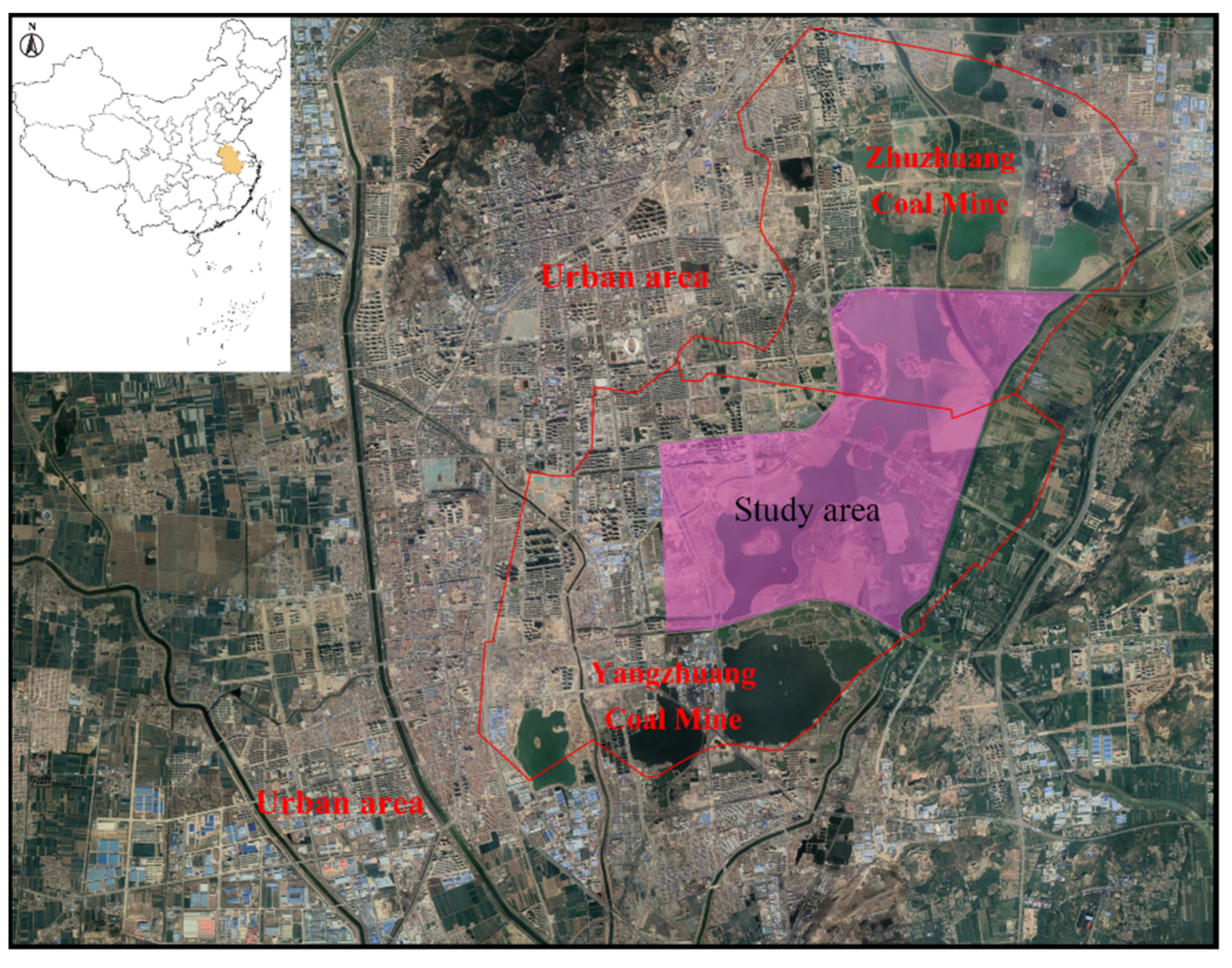
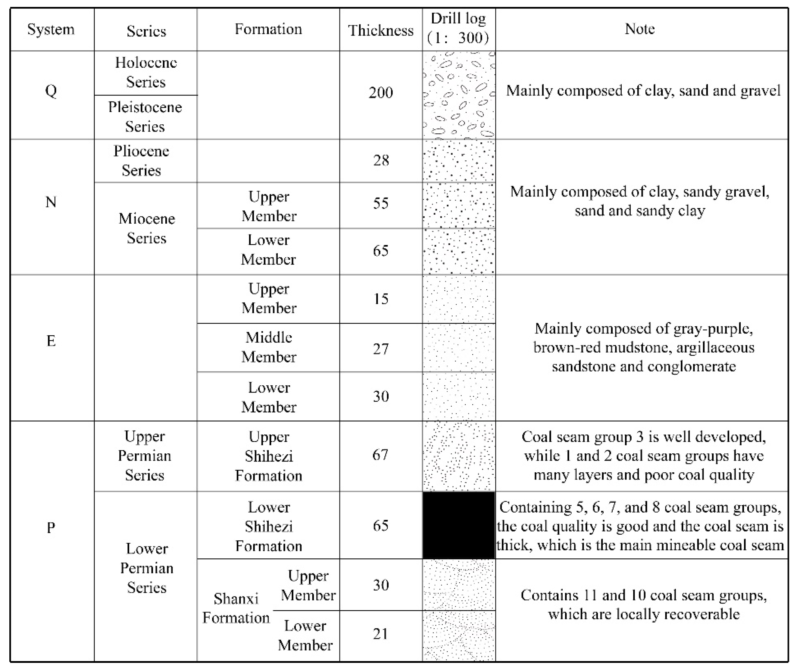
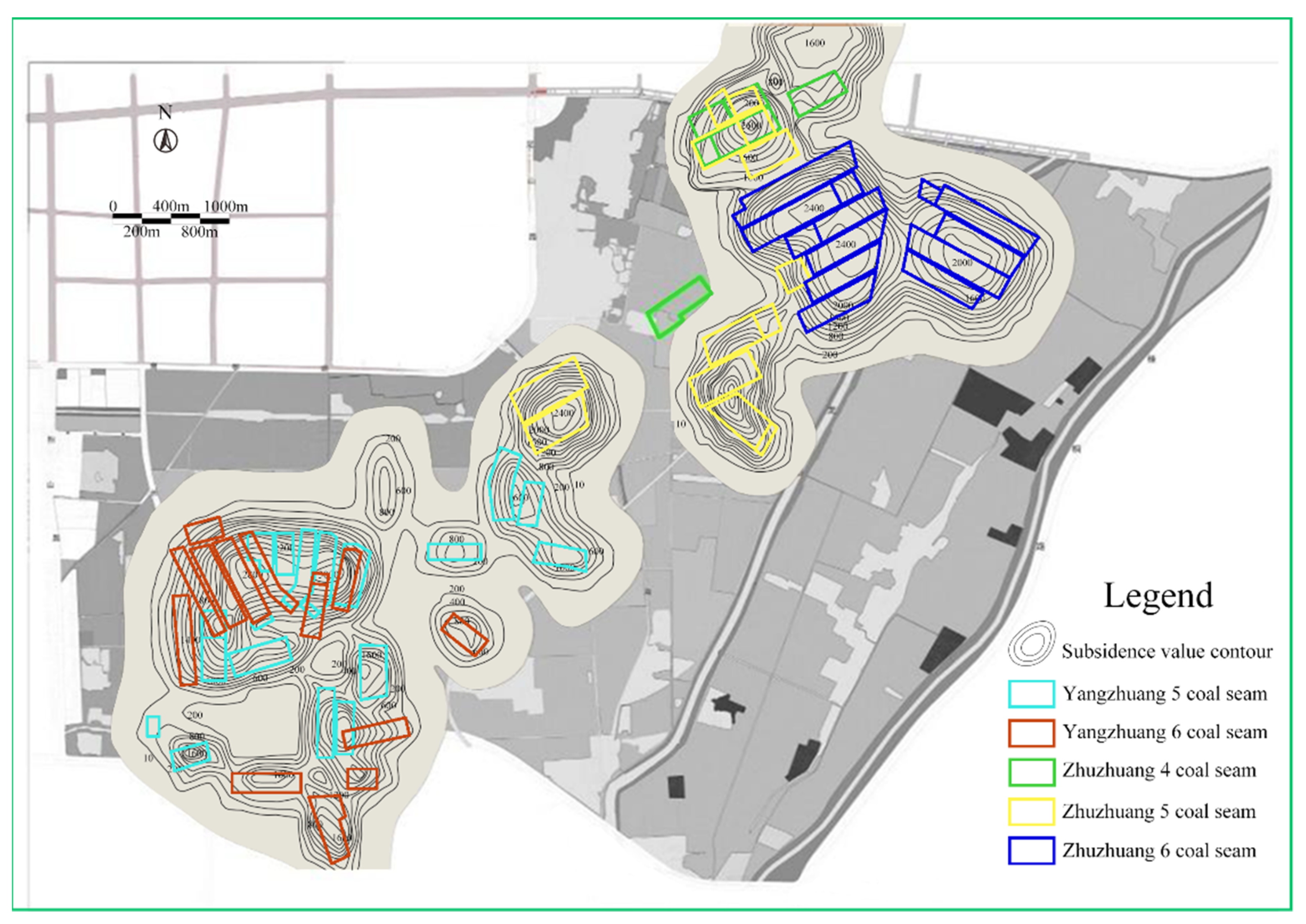
3.1. Overview of the Study Area

The Lv Jin Lake mining subsidence treatment area is located east of Huaibei City, Anhui Province. With the development and expansion of Huaibei City, the scope of its urban construction starts overlapping with that of underground coal mining. The coal mining study area was surrounded by an urban trunk road during the development of the city and is located only 2.8 km away from the city center. The surface subsidence and subsidence waterlogging due to underground mining in urban areas destroy water and land resources and seriously affect the sustainable development of the city. The geographical location of the study area is within urban limits as shown in Figure 8.
The study area is located above the Zhuzhuang and Yangzhuang coal mines. The Zhuzhuang coal mine lies northeast of the Lv Jin Lake, the Yangzhuang coal mine is located southwest and the total treatment area is 24.1 km2. The study area has flat topography with farmland and buildings. The inclination angle of the coal seam generally ranges between 7° and 15°, and the total thickness of the mineable coal seam is approximately 7.57 m. The coal mining method applied in this area is longwall mining, and the caving method is adopted to manage the roof. A graphic log of the simplified strata structure is presented in Figure 9.
The coal mining in this area has brought many negative environmental impacts as shown in Figure 10. Specifically, due to the years-long coal mining activities in the Zhuzhuang and Yangzhuang coal mines, a large area of goaf has been formed, different degrees of subsidence can be observed and a large-scale subsidence basin has been developed. The study area also has high groundwater levels and an abundant precipitation area, thereby forming a large permanent and seasonal waterlogging area.

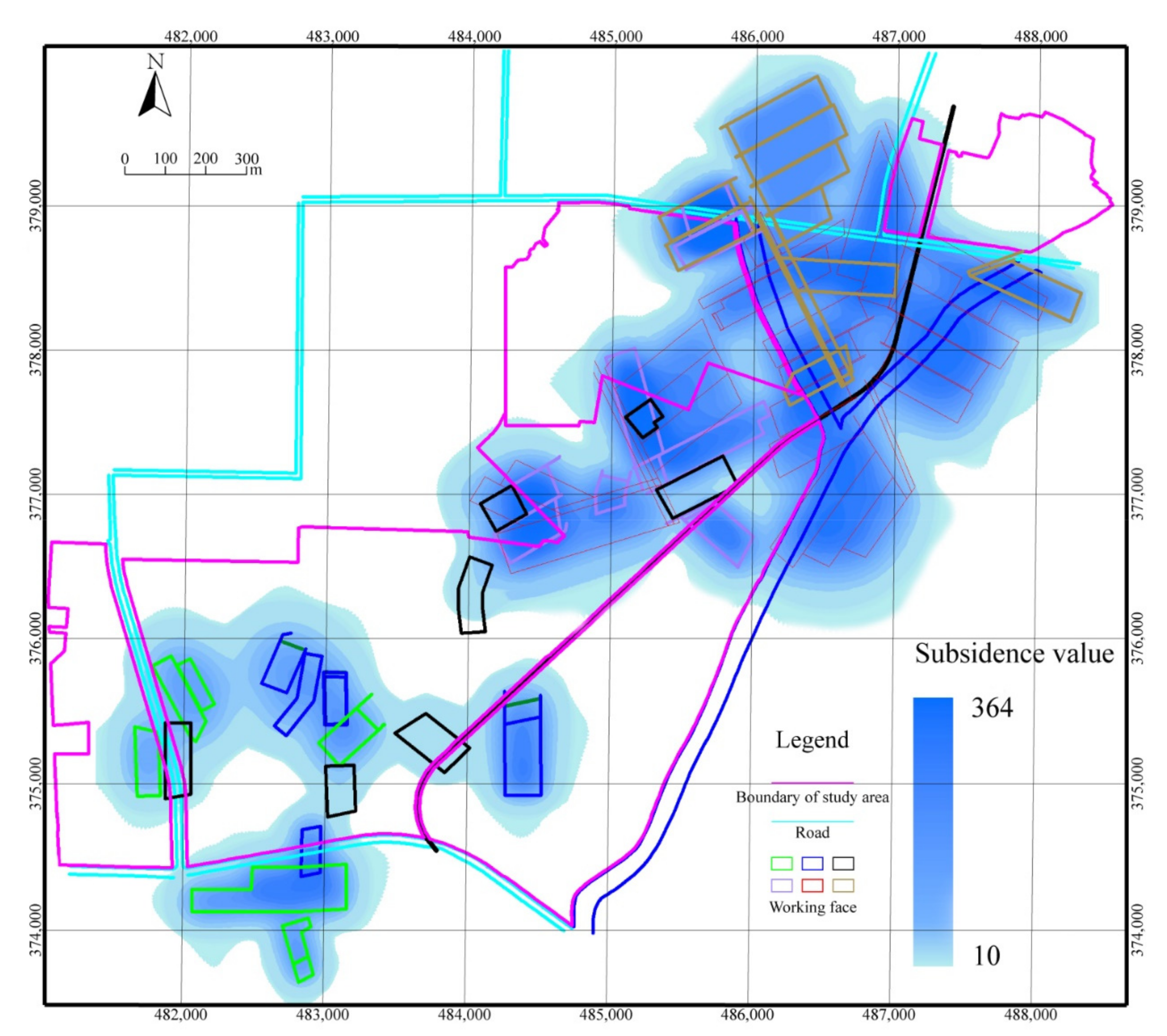
3.2. The Waterlogging Area Prediction

The scope of the waterlogging area is predicted to reconstruct the terrain by the ‘deep-excavation and shallow-filling’ method in advance. The PIM is used to predict the final surface subsidence value, the subsidence area is mainly located above the working face shown in Figure 11 and the big waterlogging area will be formed in here finally. As shown in Figure 12a, part of the waterlogging area is observed in the northern part of the study area, and the coal mining subsidence area is in an unstable subsidence state. In the future, this waterlogging area may subside sequentially, thereby resulting in the formation of a wider waterlogging area, and abundant water and land resources will be abandoned for a long time. The human–land conflict is intensified, and the development of coal-resource-based cities is restricted. Therefore, the ‘deep-excavation and shallow-filling’ method is used for treating the coal subsidence area shown in Figure 12b. The middle of the study area is then excavated, and the edge is filled. Given that the study area is surrounded by roads, the deep-excavation and shallow-filling method is not applied in the marginal partial area of the predicted waterlogging area. However, slope revetment reconstruction is performed to ensure that the partial area is non-waterlogging. The study area terrain is transformed into the final terrain design shown in Figure 12c.

3.3. The Residual Subsidence Prediction

Aiming at the non-waterlogging area, the goaf rock mass activation analysis and surface stability evaluation analysis are carried out. The coal mining subsidence in the Lv Jin Lake mining area has changed strata and rock soil’s engineering geological characteristics and properties. It has formed complex foundation conditions with bad engineering geology, which has brought difficulties and hidden dangers to the development and utilization of the land above the abandoned goaf for building. After the mining is over and the surface subsidence is stable, the mining rock system forms a new relative balance and stability. Under the action of factors such as in-situ stress, external force, rock mass strength attenuation or their combination, the balance of the rock mass system will be broken again, resulting in stress redistribution, the strata and surface movement and deformation, activating the goaf. The activation of the goaf in Lv Jin Lake is the key issue that affects the utilization of the surface buildings in the treatment area and causes the destruction of the new buildings above the area. Therefore, the residual subsidence of the area must be predicted before the land use planning. The residual subsidence model has been introduced in Chapter 2 Section 3 Part 2. The PIM parameters for predicting residual subsidence are shown in Table 2. The extreme values of residual subsidence deformation are shown in Table 3.
According to the prediction parameters of residual subsidence, the residual subsidence contour can be predicted as shown in Figure 13. Based on the analysis of Figure 13 and Table 3, the maximum residual subsidence value is 364 mm, the maximum residual inclination value is 1.3 mm/m, the maximum residual curvature deformation value is 0.01 mm/m2, the maximum residual horizontal movement value is 93 mm, the maximum residual compression deformation is 0.9 mm/m and the maximum residual tensile deformation is 0.6 mm/m. The residual horizontal deformation, curvature and inclination that occurred in the study area are within the Grade I building damage level range in the reference standard. Thus, from the perspective of surface residual deformation, new buildings in the study area are less affected by the surface residual deformation. In theory, buildings can be carried out anywhere in the area.

3.4. The Building Feasibility Analysis of the Study Area

3.4.1. The Height Calculation of Collapsed Zone and Cracked Zone

The overlying strata of the coal seam roof in the study area are medium-hard rock. The inclination angle of the Yangzhuang coal mine seam is 7–25°, and the inclination angle of the Zhuzhuang coal mine seam is 7–15°. Mainly mining the fourth, fifth and sixth coal seams, the thickness of each coal seam is 2.37, 2.90 and 3.00 m, respectively. According to the regulation [48], combining the geological data, the height calculation formulas of the collapsed zone and cracked zone are as follows:
H k = 100 M 4.7 M + 19 ± 2.2 ,
H l = 20 M + 10 ,
where M is the coal seam mining thickness, caused by the complexity of interaction between working faces, and the maximum thickness of the coal seam is taken in the calculation.
The height calculation of the collapsed zone and cracked zone above the working face of the fourth, fifth and sixed coal seams is shown in Table 4.

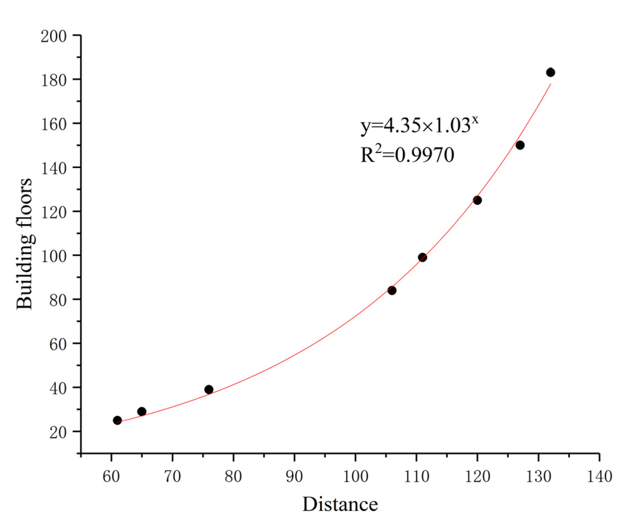
3.4.2. The Allowable Height Calculation of Buildings

According to the most common architectural design at present, the length of new buildings in the study area is 40 m, and the width is 10 m. The surface load P under a single layer action is 20 kPa. Combining with the thickness measured by drilling and the self-weight stress parameter of the soil layer, the quaternary system is 62.5 m below the ground surface, bulk density is 19 kN/m3, sandstone is below 62.5 m and shale and argillaceous sandstone have an average bulk density of 22 kN/m3. The additional stress coefficient α 0 can be found by using Boussinesq’s formula. The number of building floors can be obtained according to the additional stress α 0 .
The minimum mining depth of the fourth coal seam III426 working face is 112 m. The height sum of the collapsed zone and cracked zone is 50.85 m. The distance to the ground surface is 61.15 m. According to z / b = 6.115 , 6.0 is taken, and the additional stress coefficient α 0 is 0.1161. According to formulas (7) and (8), the maximum number of building floors is 25 floors. The theoretical design of the building floors of each working face of the fourth coal seam is shown in Table 5. By drawing the curve between the distance from the surface to the collapsed zone and cracked zone and building floors, shown in Figure 14, as the distance from the surface to the collapsed zone and cracked zone increases, the allowable value of the building floors increases with the exponential relationship. The reason is that the additional stress coefficient gradually decreases with depth, and the deeper the depth, the faster the decrease. The mining depth of the fifth and sixth coal seams’ working face is 300–680 m, the maximum height sum of the collapsed zone and cracked zone is 62.15 m; the analysis shows that the disturbance depth of the buildings is far from affecting the collapsed zone and cracked zone. Theoretically, the number of building floors has no limit.

3.5. Spatial Pattern Reconstruction of Water and Land Resources in the Study Area
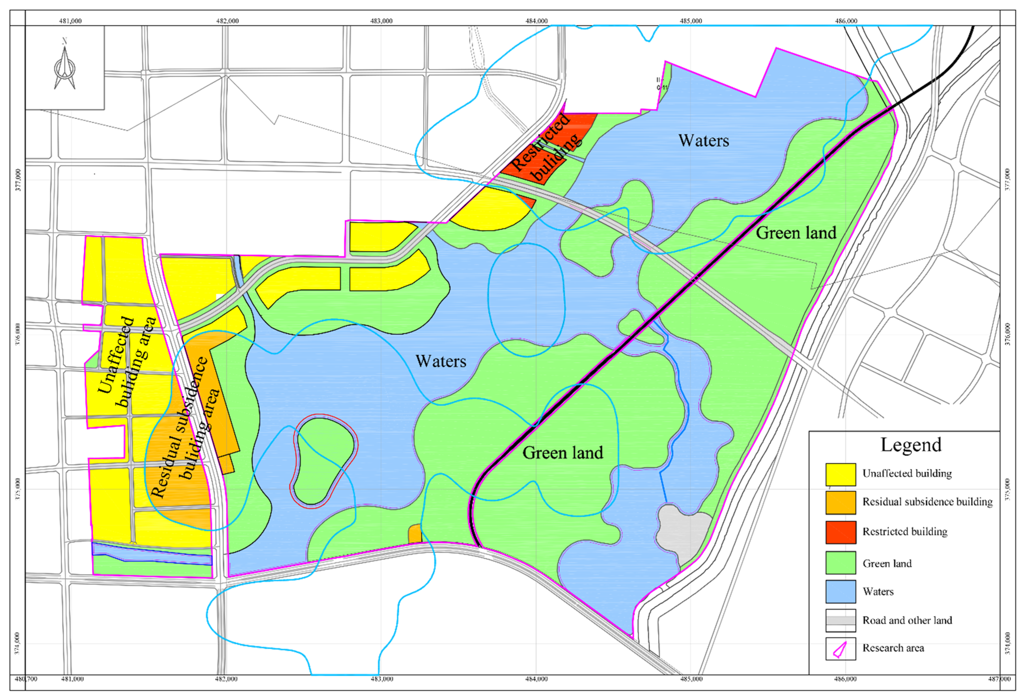
According to the above design rules, the land in the study area is rationally planned. The study area is divided into unaffected building area, building area affected by residual subsidence, restricted building area, water area and green land, as shown in Figure 15.
The utilization of water and land resources is described as follows:
(1)
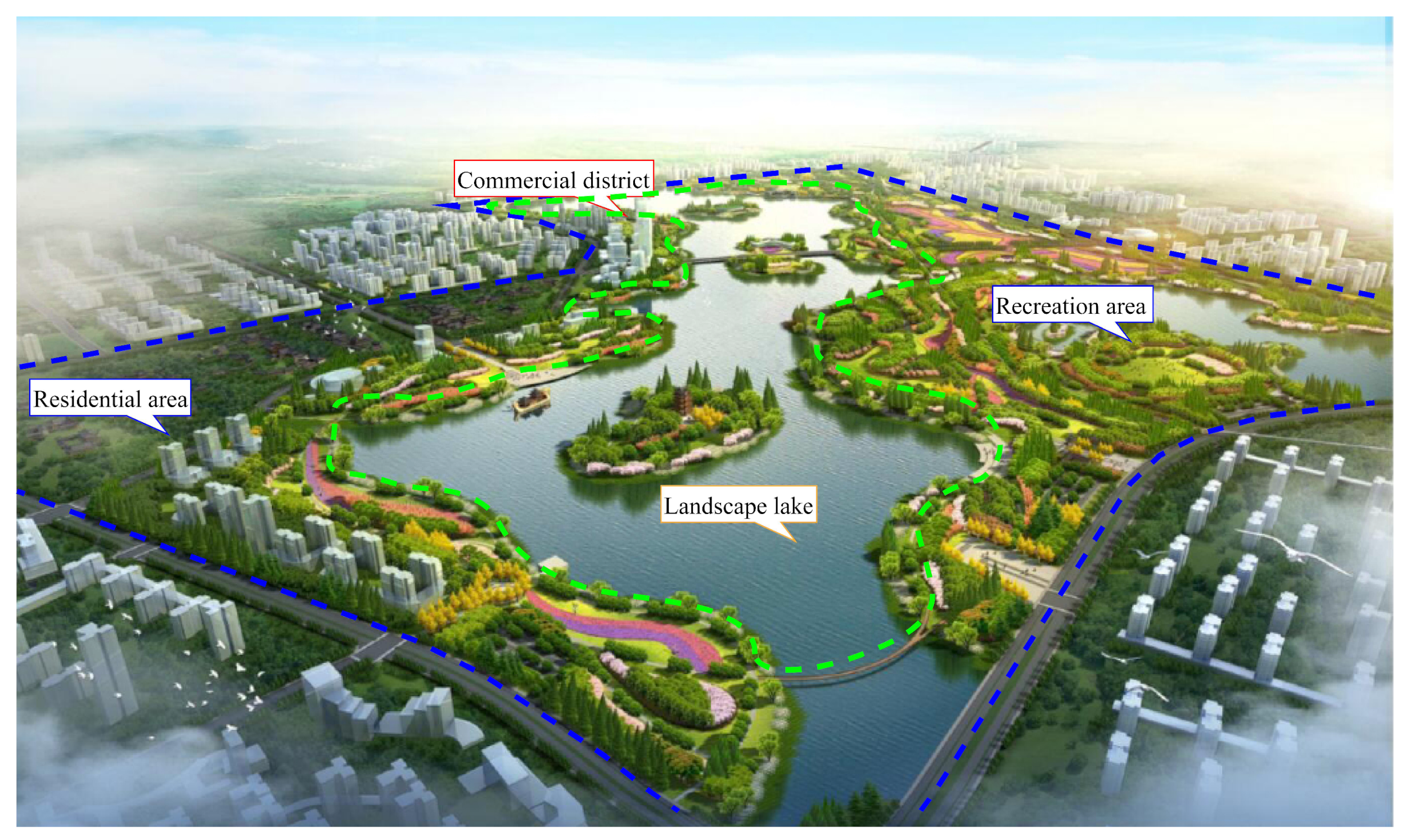
Unaffected building area is the yellow area in Figure 15. The surface deformation and the disturbing depth of the building foundation are within the safe value in this area. New buildings affected by the residual deformation are small. According to construction needs, residential houses and large shopping malls can be built in this area to solve the contradiction between the expansion of the subsidence area and the rapid growth of residential land. For several central islands in the lake, considering the complexity of the foundation and the rationality of the landscape ecology, the islands should be planned as wildlife habitats, which increases the ecological value of Lv Jin Lake Central Park. The island that the road crosses is located in the central area and can build low-level floor public health facilities.
(2)
Building area affected by residual subsidence is the orange area in Figure 15. The building in this area is affected by residual subsidence. The damage value is less than the Grade I building damage level. The building will not be damaged theoretically. When calculating the additional stress, the number of building floors has no limit. Therefore, although the building in this area is affected by mining, the impact is relatively small, and residential houses and large shopping malls can be built.
(3)
Restricted building area is the red area in Figure 15, mainly distributed in the northeast of the treatment area. It is mainly affected by the height of the collapsed zone and cracked zone in the III 426 working face of the fourth coal seam. Therefore, building structures with more than 25 floors in the nearby area is not advisable. Hotels and resorts can be built in this area, to serve the tourism industry in the Lv Jin Lake.
(4)
Green land is the green area in Figure 15. A small part of the building area is planned as a greening area to reduce soil erosion in the boundary area of deep-excavation and shallow-filling. The surface has deformations, but the surface movement and deformation are small, and the surface fluctuation does not change significantly.
(5)
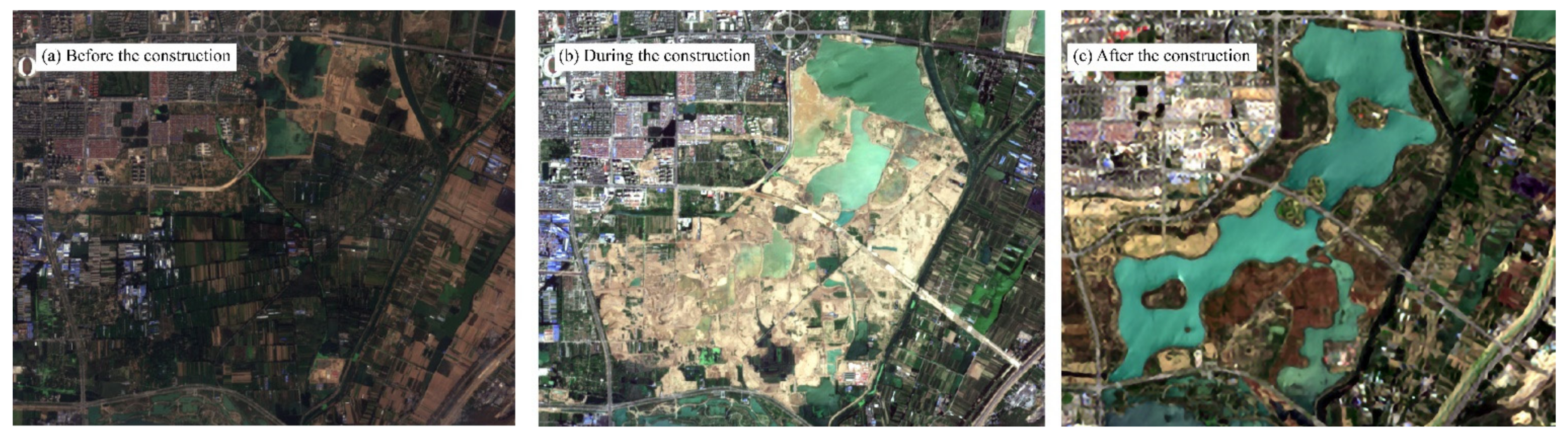
Water area is the blue area in Figure 15. It is a combination of the waterlogging area and the terrain change caused by the implementation of deep-excavation and shallow-filling projects in the coal mining subsidence. The area is planned as a water area and an important part of the plan. Given the impact of coal mining subsidence in the early stage, a large waterlogging area is formed in the Lv Jin Lake research area, which is planned as part of the water area. On the one hand, to increase the integrity of the lake, water bodies with large areas and abundant biomass and plants and their landscape environment are restored, and a new tourism route is built, which integrates sightseeing and ecological leisure. On the other hand, large areas of water are utilized to develop cage culture. This method has higher requirements on the water body. If feasible, it can significantly alleviate the tension of farmland loss caused by subsidence.
By the spatial pattern reconstruction of water and land resources, the coal mining subsidence area can be transformed into sustainable green urban zones, as shown in Figure 16. Sufficient residential houses have been constructed in the buildable area, which alleviate the human–land conflict. Furthermore, abundant water and land resources have been utilized. A large area of landscape lake and green land is reconstructed, forming the aquatic-terrestrial complex ecosystem and promoting the succession in biological communities. Meanwhile, the transportation system around the reconstruction area is built, people’s travel is facilitated and the life quality is improved. After a series of reconstruction, the environment becomes beautiful and pleasant (Figure 17).

4. Discussion

The successful treatment of the Lv Jin Lake coal mining subsidence area has promoted the development of Huaibei City. The waterlogging area in the coal mining subsidence area is taken as the core, integrating cityscape, scene life, culture creativity and eco-tourism to realize the integrated planning concept of living environment improvement and ecological restoration in the coal mining subsidence area. Furthermore, the spatial pattern of the coal mining subsidence area within urban areas is constructed. The coordinated development of people and the environment is promoted. Thus, the urban region has greatly benefited areas including economics, ecology and social humanities (Table 6).

4.1. Economic Benefits

Construction and operation and maintenance costs of approximately 75.178 million yuan are saved in engineering applications. Thirty percent of Zhuzhuang and Yangzhuang coal mine subsidence areas are restored to usable land. The total area of the wetland park in the reconstruction subsidence area is 2408 hectares, with 1634 hectares of usable land, including 534 hectares of construction land and 774 hectares of usable water areas and a storage capacity of 36.8 million m3. In the subsidence area, 54.69% of the land was transformed into flat land; 31.55% of the slope land was planted with trees, shrubs and grass; and 13.76% of the water area was used as a breeding area. The utilization rate of water and land resources reached 100%, and the direct revenue exceeded 30 billion yuan. According to the future urban land use plan, the prices of 66.7 and 12.7 hectares of commercial land sales rise after development. In terms of indirect economic benefits, the development income of construction land is expected to reach 2.5 billion yuan in the near future. The evaluation results of the ecosystem service function of Lv Jin Lake show that the economic benefits in water purification and water supply are approximately 63.72 million yuan per year.

4.2. Ecological Benefits

The Lv Jin Lake coal mining subsidence area has been transformed from a farmland ecosystem to a large-scale aquatic ecosystem before coal mining. The structure and function of the regional ecosystem have changed significantly. The ecological islands provide habitats for more than 100 species of animals and nearly 100 species of plants. It uses many abandoned lands, and has many functions such as water supply, conditioning, biodiversity conservation, leisure and entertainment. Furthermore, the landscape ecology in subsidence areas promotes ecological succession. Ecosystem services’ functions have huge potential and allow further development of eco-tourism and other ecological civilization construction industries. Meanwhile, through scientific and reasonable planning, the water system structure formed in the Lv Jin Lake subsidence area has caused important changes in the urban ecological spatial pattern. It undertakes crucial functions, such as industrial and agricultural water supply and water source protection areas. The total ecological benefits will be approximately 72.9 million yuan per year in terms of the ecosystem.

4.3. Social Benefits

The formation of the subsidence wetland park after treatment will produce good social benefits. More than 6670 hectares of cultivated land and more than 2000 hectares of construction land have been added, effectively alleviating the shortage of urban construction land. A total of 498 villages were affected by coal mining subsidence and have been relocated, and more than 2 × 10⁵ people have been successfully resettled. Employment opportunities and foundation stability are provided. The original subsidence abandoned land is built in a commercial area to promote the development of all walks of life. The subsidence waterlogging area within urban regions is planned under the concept of the human dwelling environment and eco-integration, reconstructing the urban integrate landscape environment, culture and eco-tourism. Lv Jin Lake Wetland Park improves the environmental appearance of the coal mining subsidence area; eases the human–land conflicts in mining areas; and promotes the coordinated development of society, economy and nature.

4.4. Comparison Analysis

The coal mining subsidence area is reconstructed in the following types. Firstly, the dredging and draining method [52] is applied for coal mining subsidence areas with a small surface subsidence and a small waterlogging area scope. Reasonable drainage measures are used to drain the stagnant water, and then the surface is repaired to restore its land use function. This method has a huge workload of drainage and soil filling, and the original topography changes greatly, so the renovation cost is huge. However, the method in this paper is based on the existing terrain to transform according to local conditions. The water resources are transformed into the landscape lake, and land resources are transformed into green land and building land. Secondly, the backfill reclamation method is applied [53], where coal gangue, fly ash and river mud are used to fill the coal mining subsidence area. This method has great economic benefits but may lead to secondary pollution. Thirdly, the direct use method is applied [54], where cage fish, duck, lotus root or wet-resistant crops are scattered across the large coal mining subsidence and waterlogging areas, depending on the local conditions. However, this method cannot adapt to the coal mining subsidence area within urban regions and cannot create more land use value. Fourthly, the ecological engineering reclamation method is applied [55], where land reclamation and ecological engineering technologies are combined to treat the coal mining subsidence area. This method only restores the local ecological environment and does not assess whether the land can be used for construction. Compared with the above reconstruction methods described in the literature, the spatial pattern reconstruction method proposed in this paper has a high utilization rate of water and land resources and is suitable for coal mining subsidence areas within urban areas.
In summary, the spatial pattern reconstruction of water and land resources in Lv Jin Lake subsidence promotes the sustainable development of the urban area and transforms resource-based urban areas based on coal mining into sustainable urban areas. It also provides an example for comprehensive ecological environment management in similar areas.

5. Conclusions

(1)
This study introduces a set of scientific and complete methods for reconstructing the spatial pattern of water and land resources in unstable coal mining subsidence areas within urban areas. The shortage of land resources in coal mining subsidence areas is addressed, the stability of the coal mining subsidence area is analyzed, the unstable subsidence area is reasonably planned and utilized and an ecologically livable green urban area is built to achieve a sustainable development of coal-resource-based cities.
(2)
The Lv Jin Lake in Huaibei is selected as a case study, on the basis of surface subsidence and groundwater level; the coal mining subsidence is divided into waterlogging and non-waterlogging areas. Terrain modification and reconstruction are carried out in the waterlogging area by using the deep-excavation and shallow-filling method and by reconstructing the slope. New buildings are constructed in the non-waterlogging area. The allowable height of buildings on the ground is calculated by analyzing the superposition of surface residual subsidence, the height of the collapsed zone and cracked zone and the additional stress of surface buildings. The fourth coal seam III426 working face has the minimum mining depth, and the allowable building height above is not more than 25 floors. The height of buildings in other areas theoretically has no limit.
(3)
Scientific and rational planning ensures that the abundant water and land resources are fully utilized. Residential houses and large shopping malls are built in the unaffected building area, and the building area is influenced by residual subsidence. Buildings with no more than 25 floors, hotels and resorts are built in the restricted building area. The green land can reduce soil erosion, and the large area of water increases the integrity of the study area. Abundant biomass and plants are restored, and cage culture is developed.
(4)
In the case study, a coal-resource-based city is transformed into a sustainable development city with huge economic, ecologic and social benefits. In this area, the water and land resources utilization rate reaches 100%, and the direct revenues exceed 30 billion yuan. A habitat for plants and animals is provided, and the available ecosystem services have huge potential. The shortage of urban construction land is alleviated, more than 2 × 10⁵ people have been successfully resettled and employment opportunities are abundant. The human–land conflict in mining areas is eased, and a coordinated development of society, economy and nature is promoted. The work presented in this paper may serve as a reference for similar mining subsidence area treatment projects in the future.

Author Contributions

Conceptualization, X.Z., H.C., L.D. and S.F.; methodology, X.Z., H.L. and L.Z.; software, X.Z. and F.Z.; writing—original draft preparation, X.Z. and F.Z.; writing—review and editing, X.Z., W.H., Y.Y. and X.Y.; visualization, X.Z. and F.Z.; supervision, H.C. and L.Z. All authors have read and agreed to the published version of the manuscript.

Funding

This research was funded by the National Natural Science Foundation of China (51804001), the Key University Science Research Project of Anhui Province (KJ2021A0080) and Open Project Program of Anhui Province Engineering Laboratory for Mine Ecological Remediation (KS-2021-005).

Institutional Review Board Statement

Not applicable.

Informed Consent Statement

Not applicable.

Data Availability Statement

Not applicable.

Acknowledgments

Financial support for this work, provided by the National Natural Science Foundation of China (51804001), the Key University Science Research Project of Anhui Province (KJ2021A0080) and Open Project Program of Anhui Province Engineering Laboratory for Mine Ecological Remediation (KS-2021-005) are gratefully acknowledged.

Conflicts of Interest

The authors declare no conflict of interest.

References

  1. Huang, J.; Tian, C.Y.; Xing, L.F.; Bian, Z.F.; Miao, X.X. Green and sustainable mining: Underground coal mine fully mechanized solid dense stowing-mining method. Sustainability 2017, 9, 1418. [Google Scholar] [CrossRef]
  2. Qian, D.Y.; Zhang, N.; Pan, D.J.; Xie, Z.Z.; Shimada, H.; Wang, Y.; Zhang, C.H.; Zhang, N.C. Stability of deep underground openings through large fault zones in argillaceous rock. Sustainability 2017, 9, 2153. [Google Scholar] [CrossRef]
  3. Zhang, M.W.; Shimada, H.; Sasaoka, T.; Matsui, K.; Dou, L.M. Evolution and effect of the stress concentration and rock failure in the deep multi-seam coal mining. Environ. Earth Sci. 2014, 72, 629–643. [Google Scholar] [CrossRef]
  4. Bai, E.H.; Guo, W.B.; Zhang, H.B.; Tan, Y.; Guo, M.J. In situ groundwater protection technology based on mining-conservation coordination in the middle and upper reaches of Yellow River Basin. J. China Coal Soc. 2021, 46, 907–914. [Google Scholar]
  5. Zhu, X.J.; Zha, F.; Guo, G.L.; Zhang, P.F.; Cheng, H.; Liu, H.; Yang, X.Y. Subsidence control design method and application to backfill-strip mining technology. Adv. Civ. Eng. 2021, 2021, 5177174. [Google Scholar] [CrossRef]
  6. Jiang, N.; Wang, C.X.; Pan, H.Y.; Yin, D.W.; Ma, J.B. Modeling study on the influence of the strip filling mining sequence on mining-induced failure. Energy Sci. Eng. 2020, 8, 2239–2255. [Google Scholar] [CrossRef]
  7. Marschalko, M.; Yilmaz, I.; Křístková, V.; Fuka, M.; Kubečka, K.; Bouchal, T.; Bednarik, M. Optimization of building site category determination in an undermined area prior to and after exhausting coal seams. Int. J. Rock Mech. Min. Sci. 2012, 54, 9–18. [Google Scholar] [CrossRef]
  8. Wang, C.L.; Zhang, C.S.; Zhao, X.D.; Liao, L.; Zhang, S.L. Dynamic structural evolution of overlying strata during shallow coal seam longwall mining. Int. J. Rock Mech. Min. Sci. 2018, 103, 20–32. [Google Scholar] [CrossRef]
  9. He, M.C.; Wang, Q.; Wu, Q.Y. Innovation and future of mining rock mechanics. J. Rock Mech. Geotech. Eng. 2021, 13, 1–21. [Google Scholar] [CrossRef]
  10. Xie, Z.Z.; Zhang, N.; Yuan, Y.X.; Xu, G.; Wei, Q. Study on safety control of composite roof in deep roadway based on energy balance theory. Sustainability 2019, 11, 3688. [Google Scholar] [CrossRef]
  11. Wang, F.; Jiang, B.Y.; Chen, S.J.; Ren, M.Z. Surface collapse control under thick unconsolidated layers by backfilling strip mining in coal mines. Int. J. Rock Mech. Min. Sci. 2019, 113, 268–277. [Google Scholar] [CrossRef]
  12. Zhang, Y.; Cao, S.G.; Zhang, N.; Zhao, C.Z. The application of short-wall block backfill mining to preserve surface water resources in northwest China. J. Clean. Prod. 2020, 261, 121232. [Google Scholar] [CrossRef]
  13. Huang, Y.L.; Li, J.M.; Ma, D.; Gao, H.D.; Guo, Y.C.; Ouyang, S.Y. Triaxial compression behaviour of gangue solid wastes under effects of particle size and confining pressure. Sci. Total Environ. 2019, 693, 133607. [Google Scholar] [CrossRef] [PubMed]
  14. Nie, L.; Wang, H.; Xu, Y.; Li, Z. A new prediction model for mining subsidence deformation: The arc tangent function model. Nat. Hazards 2014, 75, 2185–2198. [Google Scholar] [CrossRef]
  15. Hu, Z.Q.; Duo, L.H.; Shao, F. Optimal Thickness of Soil Cover for Reclaiming Subsided Land with Yellow River Sediments. Sustainability 2018, 10, 3853. [Google Scholar] [CrossRef]
  16. Liu, H.; Zhang, M.; Su, L.J.; Chen, X.X.; Liu, C.F.; Sun, A.G. A boundary model of terrain reconstruction in a coal-mining subsidence waterlogged area. Environ. Earth Sci. 2021, 80, 187. [Google Scholar] [CrossRef]
  17. Hu, B.N.; Guo, W.Y. Mining subsidence area status, syntheses governance model and governance recommendation. Coal Min. Technol. 2018, 23, 1–4. [Google Scholar]
  18. Zhao, J.H.; Jiang, N.; Yin, L.M.; Bai, L.Y. The effects of mining subsidence and drainage improvements on a waterlogged area. Bull. Eng. Geol. Environ. 2018, 78, 3815–3831. [Google Scholar]
  19. Faunt, C.C.; Sneed, M.; Traum, J.; Brandt, J.T. Water availability and land subsidence in the Central Valley, California, USA. Hydrogeol. J. 2015, 24, 675–684. [Google Scholar] [CrossRef]
  20. Wu, Q.Y.; Pang, J.W.; Qi, S.Z.; Li, Y.P.; Han, C.C.; Liu, T.X.; Huang, L.M. Impacts of coal mining subsidence on the surface landscape in Longkou city, Shandong Province of China. Environ. Earth Sci. 2009, 59, 783–791. [Google Scholar]
  21. Shang, Y.Z.; Lu, S.B.; Li, X.F.; Hei, P.F.; Lei, X.H.; Gong, J.G.; Liu, J.H.; Zhai, J.Q.; Wang, H. Balancing development of major coal bases with available water resources in China through 2020. Appl. Energy 2017, 194, 735–750. [Google Scholar] [CrossRef]
  22. Liu, H.; Zhu, X.J.; Cheng, H.; Su, L.J.; Dai, L.J.; Zheng, L.G.; Fang, S.Z.; Jiang, C.L.; Zhang, Q.; Sun, Q.Y.; et al. Key technology of human environment and ecological reconstruction in high submersible level coal mining subsidence area: A case study from Lüjin Lake, Huaibei. J. China Coal Soc. 2021, 46, 4021–4032. [Google Scholar]
  23. Singh, S.K.; Pandey, A.C. Geomorphology and the controls of geohydrology on waterlogging in Gangetic Plains, North Bihar, India. Environ. Earth Sci. 2013, 71, 1561–1579. [Google Scholar] [CrossRef]
  24. Blanchette, M.L.; Lund, M.A. Pit lakes are a global legacy of mining: An integrated approach to achieving sustainable ecosystems and value for communities. Curr. Opin. Environ. Sustain. 2016, 23, 28–34. [Google Scholar] [CrossRef]
  25. Pérez-Sindín, X.; Blanchette, M.L. Correction to: Understanding public perceptions of a new Pit Lake in as pontes, Spain. Mine Water Environ. 2020, 39, 657. [Google Scholar] [CrossRef]
  26. Dhakate, R.; Modi, D.; Rao, V.V.S.G. Impact assessment of coal mining on river water and groundwater and its interaction through hydrological, isotopic characteristics, and simulation flow modeling. Arab. J. Geosci. 2018, 12, 8. [Google Scholar] [CrossRef]
  27. Zhu, X.J.; Ning, Z.Y.; Cheng, H.; Zhang, P.F.; Sun, R.; Yang, X.Y.; Liu, H. A novel calculation method of subsidence waterlogging spatial information based on remote sensing techniques and surface subsidence prediction. J. Clean. Prod. 2022, 335, 130366. [Google Scholar] [CrossRef]
  28. Hu, Z.Q.; Xiao, W.; Zhao, Y.L. Re-discussion on coal mine eco-environment concurrent mining and reclamation. J. China Coal Soc. 2020, 45, 351–359. [Google Scholar]
  29. Li, F.M. Discussion on several technical problems in comprehensive treatment of surface ground subsidence caused by coal mining operation. Coal Sci. Technol. 2003, 33, 59–60. [Google Scholar]
  30. Tan, X.H.; Peng, Y.L.; Liu, S.L.; Liu, P. Landscape pattern and ecotourism carrying capacity of Pan’an Lake wetland park in Xuzhou City, China. Desalination Water Treat. 2020, 188, 288–296. [Google Scholar] [CrossRef]
  31. Xu, J.X.; Yin, P.C.; Hu, W.M.; Fu, L.L.; Zhao, H. Assessing the ecological regime and spatial spillover effects of a reclaimed mining subsided lake: A case study of the Pan’an Lake wetland in Xuzhou. PLoS ONE 2020, 15, e0238243. [Google Scholar] [CrossRef] [PubMed]
  32. Hu, Z.Q. The 30 years’ land reclamation and ecological restoration in China: Review, rethinking and prospect. Coal Sci. Technol. 2019, 47, 25–36. [Google Scholar] [CrossRef]
  33. Hu, Z.Q.; Xiao, W. Optimization of concurrent mining and reclamation plans for single coal seam: A case study in northern Anhui, China. Environ. Earth Sci. 2012, 68, 1247–1254. [Google Scholar] [CrossRef]
  34. Chugh, Y.P. Concurrent mining and reclamation for underground coal mining subsidence impacts in China. In Proceedings of the 2nd International Symposium on Land Reclamation and Ecological Restoration (LRER), Xian, China, 20–23 October 2017; pp. 315–332. [Google Scholar]
  35. Hu, Z.; Xiao, W.; Fu, Y. Innovations of concurrent mining and reclamation for underground coal mines in China. In Proceedings of the 16th International Symposium on Environmental Issues and Waste Management in Energy and Mineral Production (SWEMP)/International Symposium on Computer Applications (CAMI), Istanbul, Turkey, 5–7 October 2016. [Google Scholar]
  36. Guan, J.; Yu, P. Does coal mining have effects on land use changes in a coal resource-based city? Evidence from Huaibei City on the North China Plain. Int. J. Environ. Res. Public Health 2021, 18, 11616. [Google Scholar] [CrossRef] [PubMed]
  37. Li, G.S.; Hu, Z.Q.; Li, P.Y.; Yuan, D.Z.; Wang, W.J.; Han, J.Z.; Yang, K. Optimal layout of underground coal mining with ground development or protection: A case study of Jining, China. Res. Policy 2022, 76, 102639. [Google Scholar] [CrossRef]
  38. Wu, J.; Bai, Z.K. Spatial and temporal changes of the ecological footprint of China’s resource-based cities in the process of urbanization. Res. Policy 2022, 75, 102491. [Google Scholar] [CrossRef]
  39. He, Y.; Lin, Y.; Zhou, G.; Zhu, Y.; Tang, K. Spatial pattern and drivers of urbanization in China’s mid-level developing urban agglomeration: A case study of Chang-Zhu-Tan. Reg. Sustain. 2021, 2, 83–97. [Google Scholar] [CrossRef]
  40. Ge, X.J.; Liu, X.X. Urban land use efficiency under resource-based economic transformation—A case study of Shanxi Province. Land 2021, 10, 850. [Google Scholar] [CrossRef]
  41. Wu, Z.H.; Lei, S.G.; Yan, Q.W.; Bian, Z.F.; Lu, Q.Q. Landscape ecological network construction controlling surface coal mining effect on landscape ecology: A case study of a mining city in semi-arid steppe. Ecol. Indic. 2021, 133, 108403. [Google Scholar] [CrossRef]
  42. Yang, D.W.; Gao, X.L.; Xu, L.X.; Guo, Q.H. Constraint-adaptation challenges and resilience transitions of the industry–environmental system in a resource-dependent city. Res. Conserv. Recycl. 2018, 134, 196–205. [Google Scholar] [CrossRef]
  43. Xiang, Z.; Liu, X.Y. Coal-based transformation of cities in Shandong Province, China. Chin. J. Popul. Res. Environ. 2015, 13, 358–364. [Google Scholar] [CrossRef]
  44. Lin, C.C.; Zheng, L.G.; Wei, X.P.; Dong, X.L.; Chen, X. Study on landscape pattern changes before and after the governance in zhonghu coal mining subsidence area in Huaibei. Adm. Tech. Environ. Monit. 2021, 33, 14–19. [Google Scholar]
  45. Liu, Y.; Zhu, J.R.; Gao, W.H.; Guo, Z.H.; Xue, C.; Pang, J.Y.; Shu, L.Z. Effects of biochar amendment on bacterial and fungal communities in the reclaimed soil from a mining subsidence area. Environ. Sci. Pollut. Res. Int. 2019, 26, 34368–34376. [Google Scholar] [CrossRef]
  46. Litwiniszyn, J. Application of the equation of stochastic processes to mechanics of loose bodies. Arch. Mech. Stos. 1956, 8, 393–411. [Google Scholar]
  47. Liu, B.C. Stochastic medium theory and its application in surface subsidence caused by excavation. Chin. J. Nonferrous Met. 1992, 2, 8–14. [Google Scholar]
  48. China Coal Research Institute. Buildings, water bodies, railways and main shafts and coal pillars and coal mining regulations. China Coal Ind. Press 2017, in press. [Google Scholar]
  49. Hu, Q.F.; Deng, X.B.; Feng, R.M.; Li, C.Y.; Wang, X.J.; Jiang, T. Model for calculating the parameter of the Knothe time function based on angle of full subsidence. Int. J. Rock Mech. Min. Sci. 2015, 78, 19–26. [Google Scholar] [CrossRef]
  50. Cui, X.M.; Wang, J.C.; Liu, Y.S. Prediction of progressive surface subsidence above longwall coal mining using a time function. Int. J. Rock Mech. Min. Sci. 2001, 38, 1057–1063. [Google Scholar] [CrossRef]
  51. Zhu, X.J.; Guo, G.L.; Zha, J.F.; Chen, T.; Fang, Q.; Yang, X.Y. Surface dynamic subsidence prediction model of solid backfill mining. Environ. Earth Sci. 2016, 75, 1007. [Google Scholar] [CrossRef]
  52. Bian, Z.F.; Zhang, G.L. Principle of dredging and draining method of subsided land reclamation for coal mining and its application. J. China Univ. Min. Technol. 1996, 25, 84–88. [Google Scholar]
  53. Bernadette, U.U.; Ogbonnaya, L.; Oyem, E.U. Modeling and characterization of mine pit backflling/reclamation materials around Gyel’A’ and Kantoma areas of Plateau state using integrated method. Modeling Earth Syst. Environ. 2021, 2022, 3385–3398. [Google Scholar]
  54. Pan, H.Y.; Cheng, A.G. Comparative study on comprehensive control policies for mining subsidence at home and abroad. Energy Technol. Manag. 2020, 45, 25–28 + 32. [Google Scholar]
  55. Li, Q.T.; Peng, T.; Yang, J.; He, J.Q.; Wang, J.W. Investigate ecological restoration project of abandoned mines in Beijing-Tianjin-Hebei area. World Nonferrous Met. 2020, 6, 259–260. [Google Scholar]
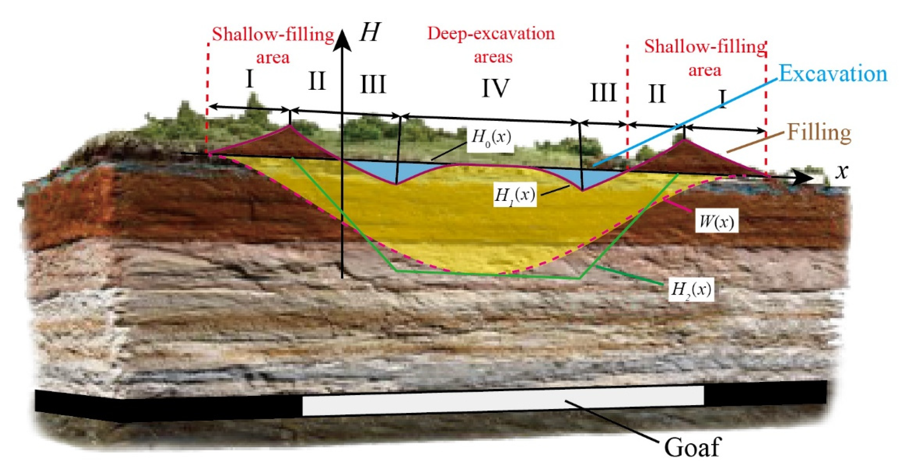
Figure 1. Schematic diagram of the formation of waterlogging in the subsidence area.
Sustainability 14 11397 g001
Figure 2. Photo of the coal mining subsidence waterlogging with high groundwater level.
Sustainability 14 11397 g002
Figure 3. Reconstruction method of the spatial pattern of water and land resources.
Sustainability 14 11397 g003
Figure 4. Schematic of surface subsidence calculation by PIM.
Sustainability 14 11397 g004
Figure 5. Change of subsidence and waterlogging area with the advance of the coal mining panel.
Sustainability 14 11397 g005
Figure 6. Schematic of the formation of the waterlogging area.
Sustainability 14 11397 g006
Figure 7. Schematic of deep-excavation and shallow-filling method.
Sustainability 14 11397 g007
Figure 8. Schematic of the geographical location of the study area (the remote sensing image is Sentinel-2 satellite image).
Sustainability 14 11397 g008
Figure 9. Schematic of drill hole columnar section in the study area.
Sustainability 14 11397 g009
Figure 10. Photo of environmental damage caused by coal mining in study area.
Sustainability 14 11397 g010
Figure 11. Schematic of the predicted waterlogging area.
Sustainability 14 11397 g011
Figure 12. Changes in the treatment process of waterlogging area (the remote sensing images are Sentinel-2 satellite image).
Sustainability 14 11397 g012
Figure 13. Nephogram of residual subsidence in the study area.
Sustainability 14 11397 g013
Figure 14. Curve relationship between the distance from surface to collapsed zone and cracked and building floors.
Sustainability 14 11397 g014
Figure 15. Treatment planning of coal mining subsidence area.
Sustainability 14 11397 g015
Figure 16. Prospects of sustainable development in coal mining subsidence area.
Sustainability 14 11397 g016
Figure 17. Planning and design status of Lv Jin Lake coal mining subsidence area, (a) conceptual graph of Lv Jin Lake, (b) live photo of Lv Jin Lake.
Sustainability 14 11397 g017
Table 1. Mathematical model of terrain reconstruction in subsidence area.
Areax Range of CoordinatesDesign Elevation of Filling
Irs1 < x < −b/kl + b/k < x < l + s2 + rH0 + W(x)
IIb/k < x < x0Lx0 < x < l + b/kH0 + W(x) − H2(x)
IIIx0 < x < (Wmaxb)/kL − (Wmaxb)/k < x < lx0H0 + W(x) − H2(x)
IV(Wmaxb)/k < x < l/2L/2 < x < l − (Wmaxb)/kH0 + W(x) − Wmax
Table 2. Prediction parameters of probability integral method.
Prediction
Parameters
Subsidence q/mTangent of Major
Influence Angle tanβ
Deviation of Influence Point S/mPropagation Angle s/°Displacement Factor b
Subsidence1.181.60860.36
Residual subsidence0.0561.60860.36
Table 3. The extreme value of residual subsidence deformation.
Subsidence (mm)Inclination (mm/m)Curvature (mm/m2)Horizontal Movement
(mm)
Horizontal
Deformation (mm/m)
3641.30.0193−0.9,0.6
Table 4. Maximum height of collapsed zone and cracked zone in coal seams.
Coal SeamThe FourthThe FifthThe Sixth
Hk (m)10.0612.6511.26
Hl (m)40.7949.5044.64
Hk + Hl (m)50.8562.1555.90
Table 5. The building floors above the fourth coal seam.
NameThe Distance from Surface to
Collapsed Zone and Cracked Zone/m
Building Floors
III4420132183
III4418127150
III4416120125
III441711199
III441510684
III44237639
III4286529
III4266125
Table 6. Benefits of coal mining subsidence area after treatment.
TypeBenefits
EconomyIt provides 1634 hectares of usable land and 774 hectares of usable water areas. The utilization rate of water and land resources reached 100%. The revenue exceeded 30 billion yuan.
EcologyThe structure and function of the regional ecosystem have changed significantly. They have many functions, such as water supply, conditioning, biodiversity conservation and leisure.
SocietyA total of 498 villages affected by coal mining subsidence
have been relocated, and more than 2 × 10⁵ people have been successfully resettled, easing human–land conflicts.
Publisher’s Note: MDPI stays neutral with regard to jurisdictional claims in published maps and institutional affiliations.

