Comprehensive Water Inrush Risk Assessment Method for Coal Seam Roof


Abstract
1. Introduction
2. Materials and Methods
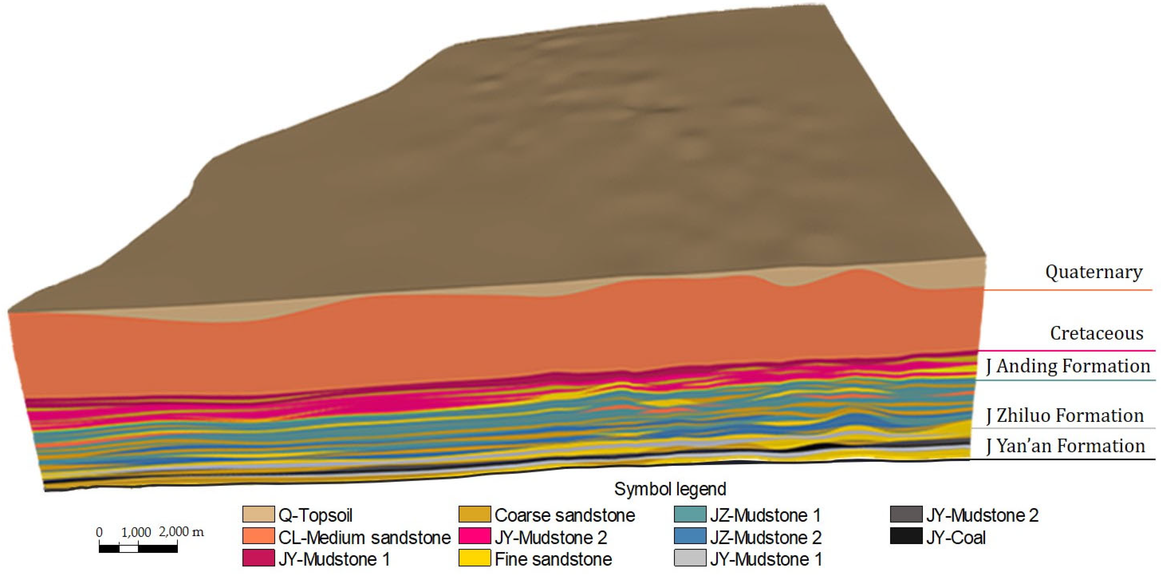
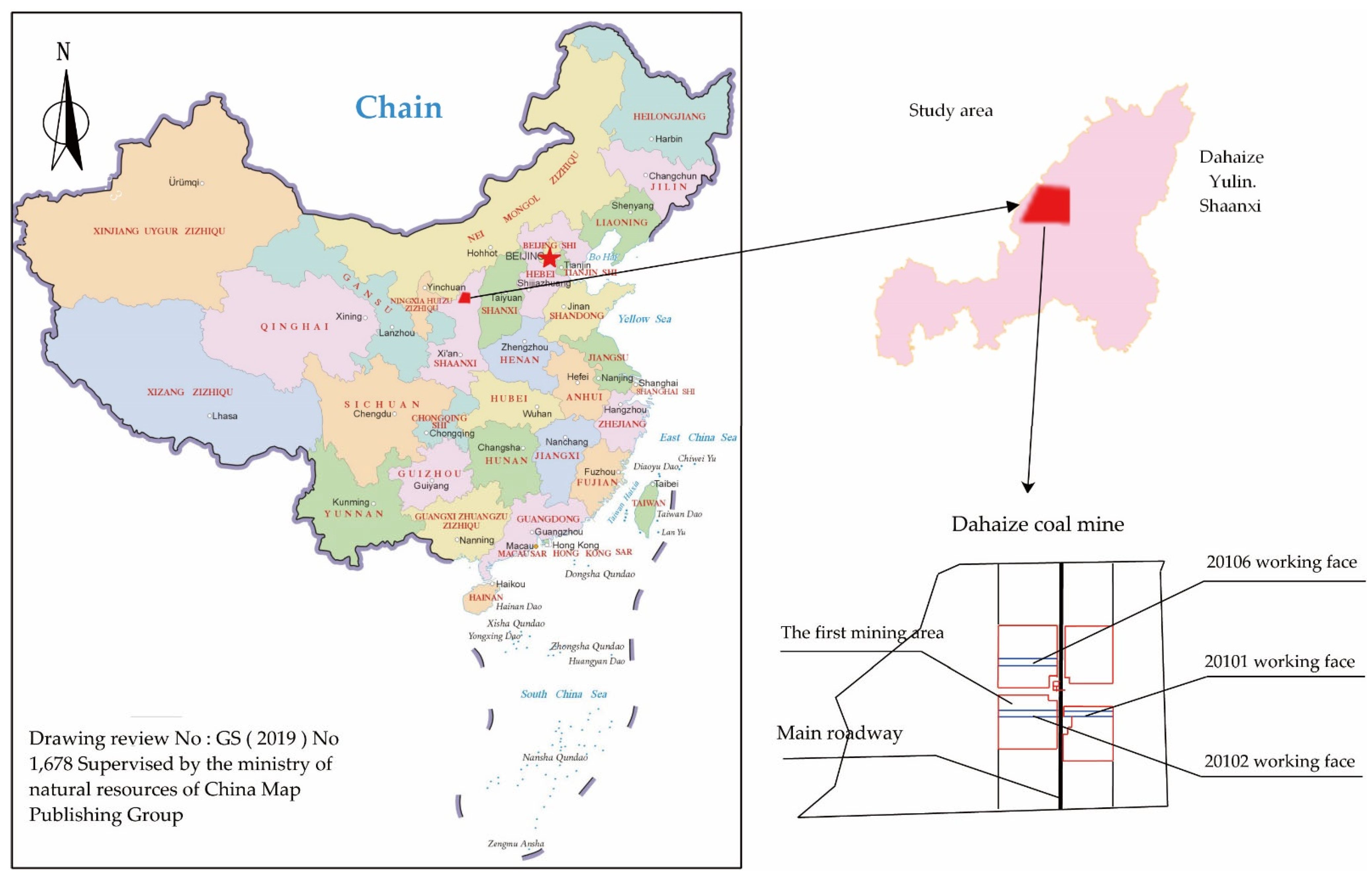
2.1. Geological and Hydrogeological Conditions
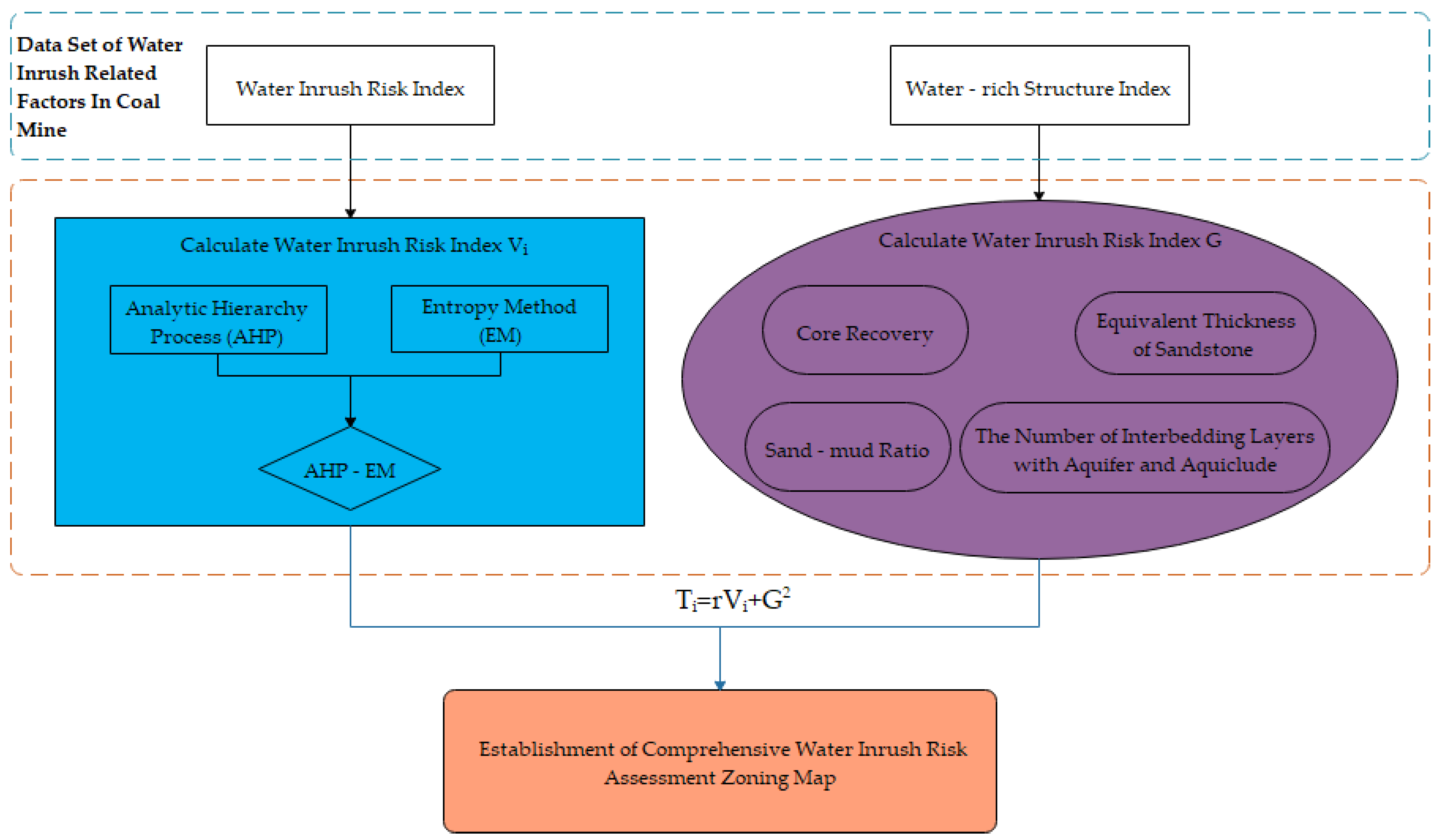
2.2. Comprehensive Water Inrush Risk Assessment Method
- The water inrush risk index was established by combining AHP and EM with the moment estimation method;
- The water inrush structure index was used to calculate the water-rich in the study area, and establish the water inrush model;
- The weighted superposition of the above two models were carried out by using the weighted formula to establish a comprehensive water inrush risk assessment model.
2.2.1. Water Inrush Risk Index
Analytic Hierarchy Process (AHP)
Entropy Method (EM)
AHP-EM
2.2.2. Water-Rich Structure Index
2.2.3. Comprehensive Water Inrush Risk Assessment
2.3. Determination of Risk Control Factors of Comprehensive Water Inrush in Dahaize Coal Mine
2.3.1. Control Factors of Water Inrush Risk Index
Core Recovery (K1)
Aquifer Thickness (K2)
Distance from Indirect Aquifer to Coal Seam (K3)
Aquiclude Thickness (K4)
Height of Water-Conducting Fracture Zone (K5)
2.3.2. Control Factors of Water-Rich Structure Index
Core Recovery (K1)
The Number of Interbedding Layers with Aquifer and Aquiclude (N)
Sand-Mud Ratio (s)
Equivalent Thickness of Sandstone (L)
3. Results and Discussion
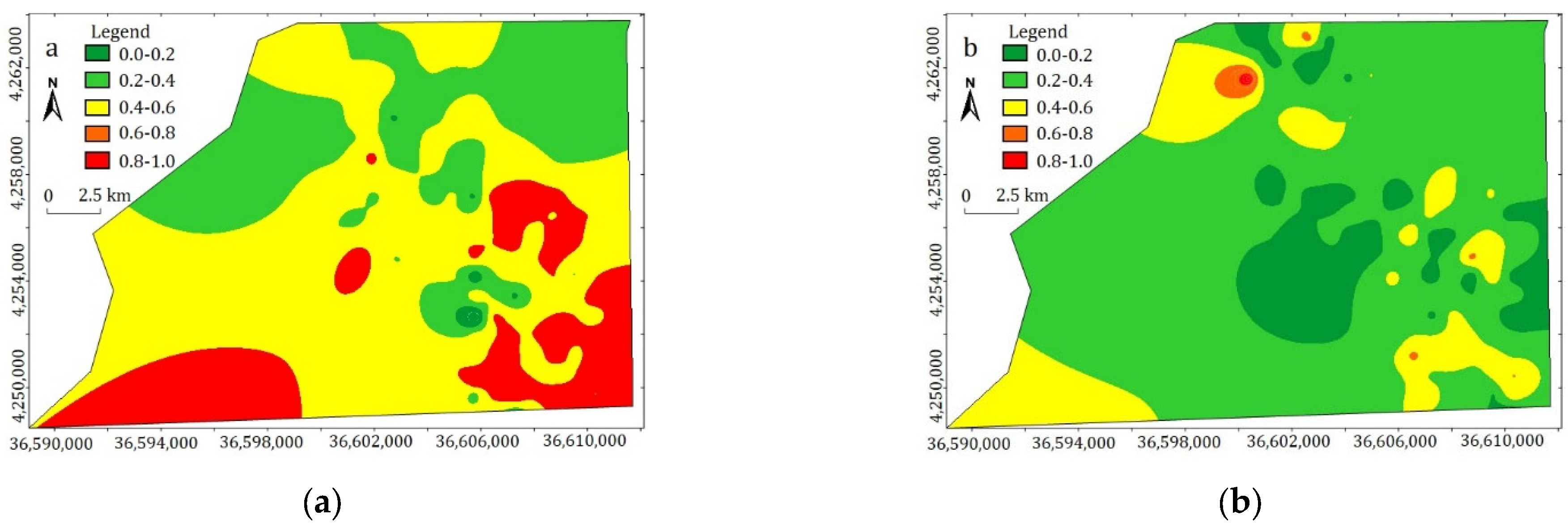
3.1. Calculation Results of Water Inrush Risk Index
3.1.1. Weight Calculation Based on AHP
3.1.2. Weight Calculation Based on EM
3.1.3. Weight Calculation Based on AHP-EM
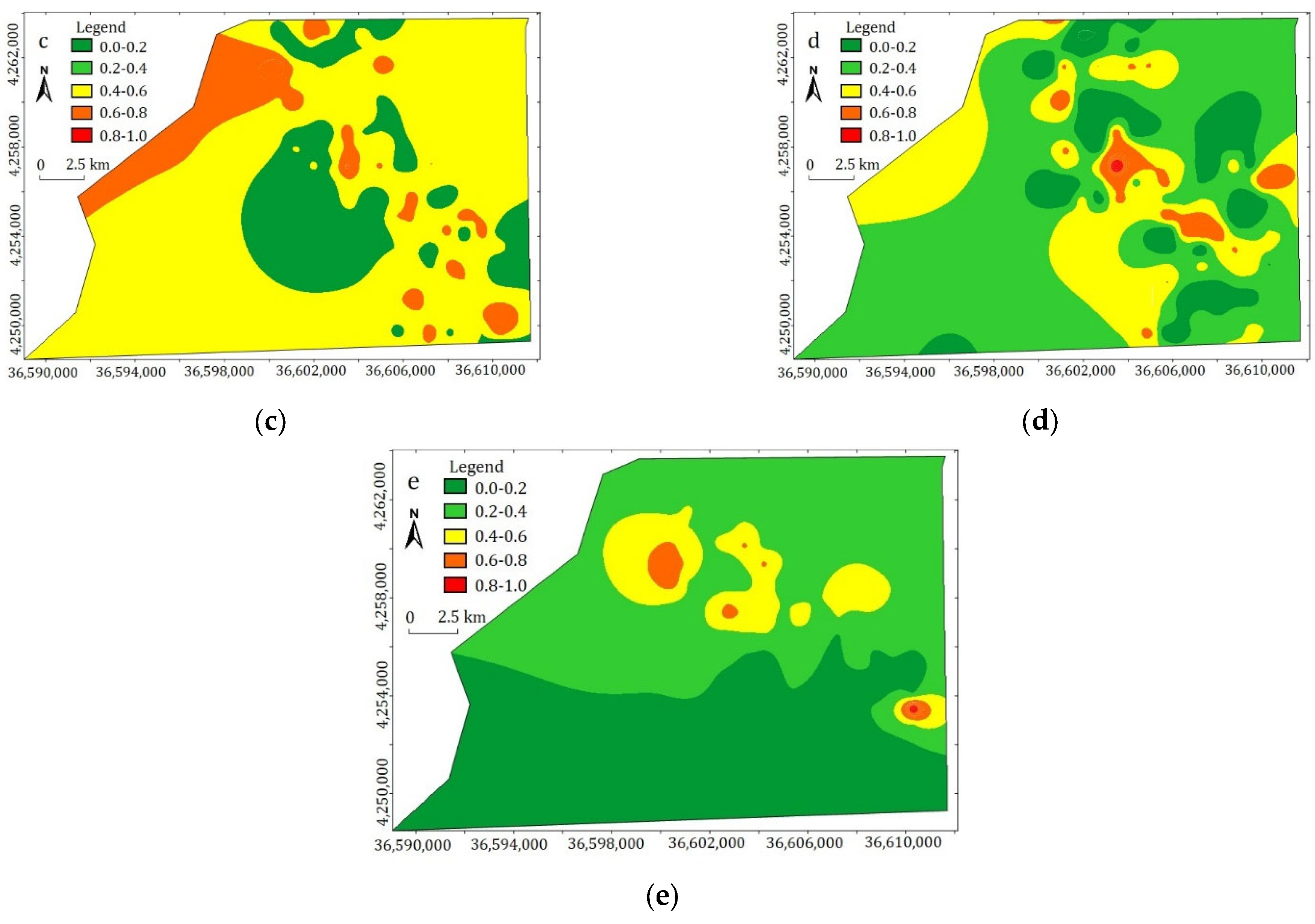
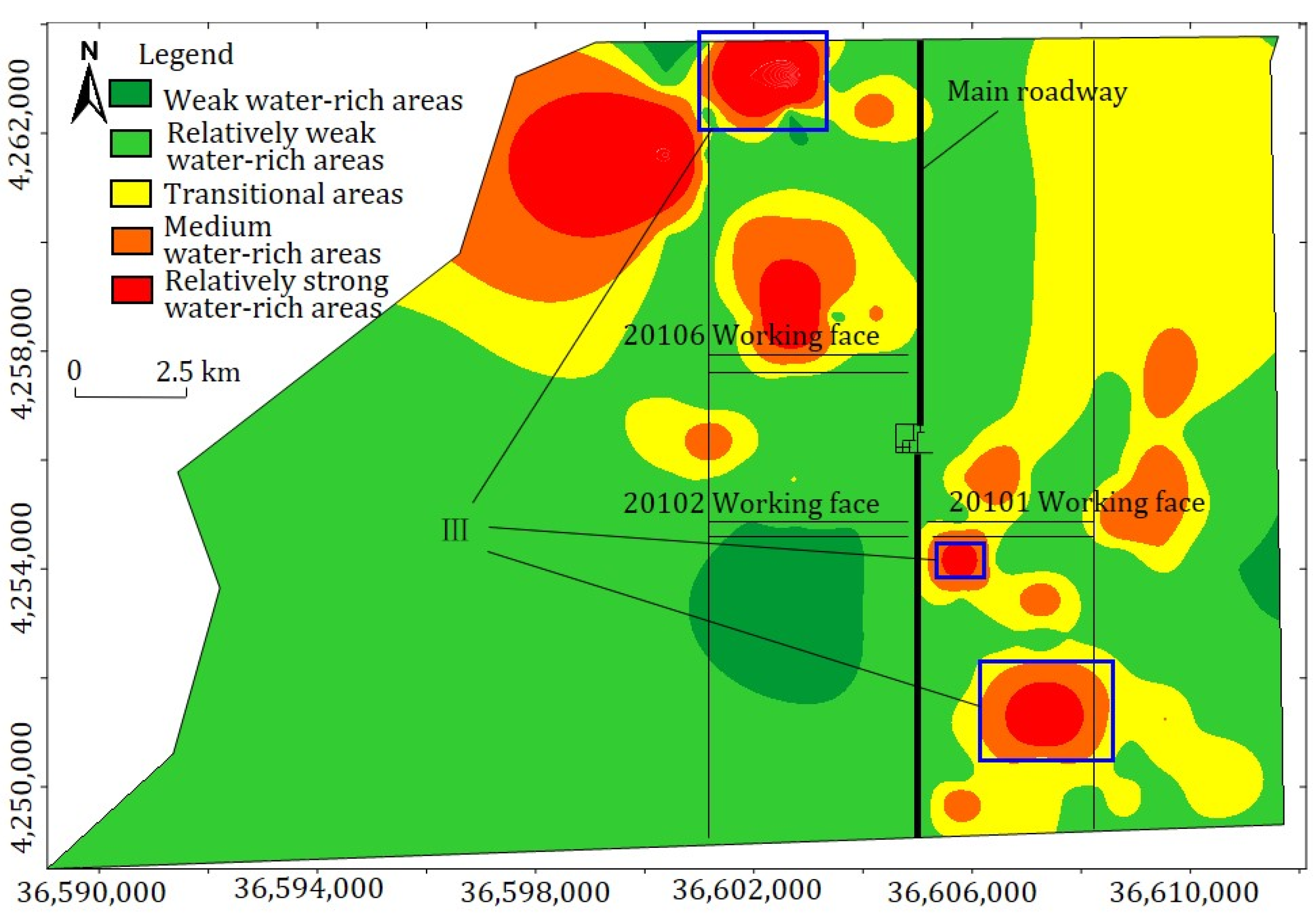
3.2. Calculation Results of Water-Rich Structure Index
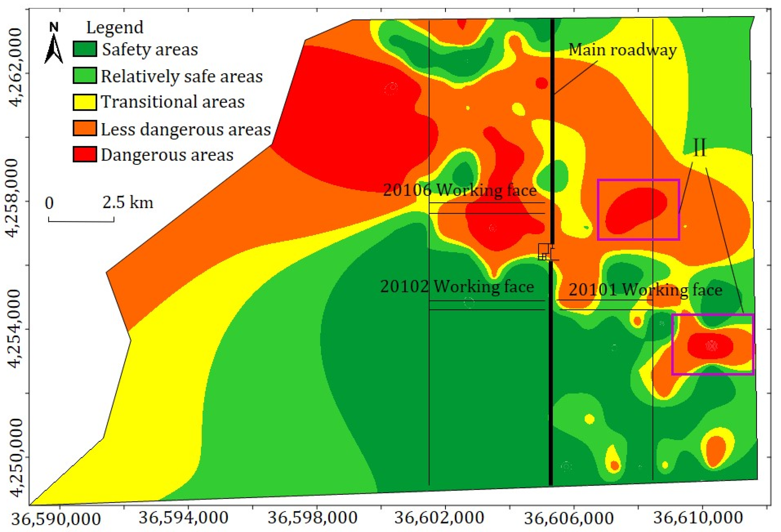
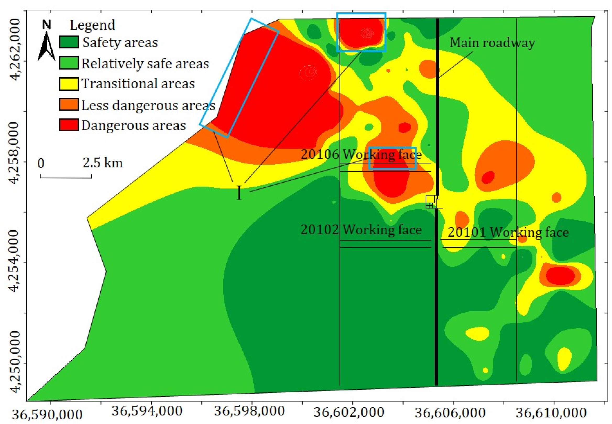
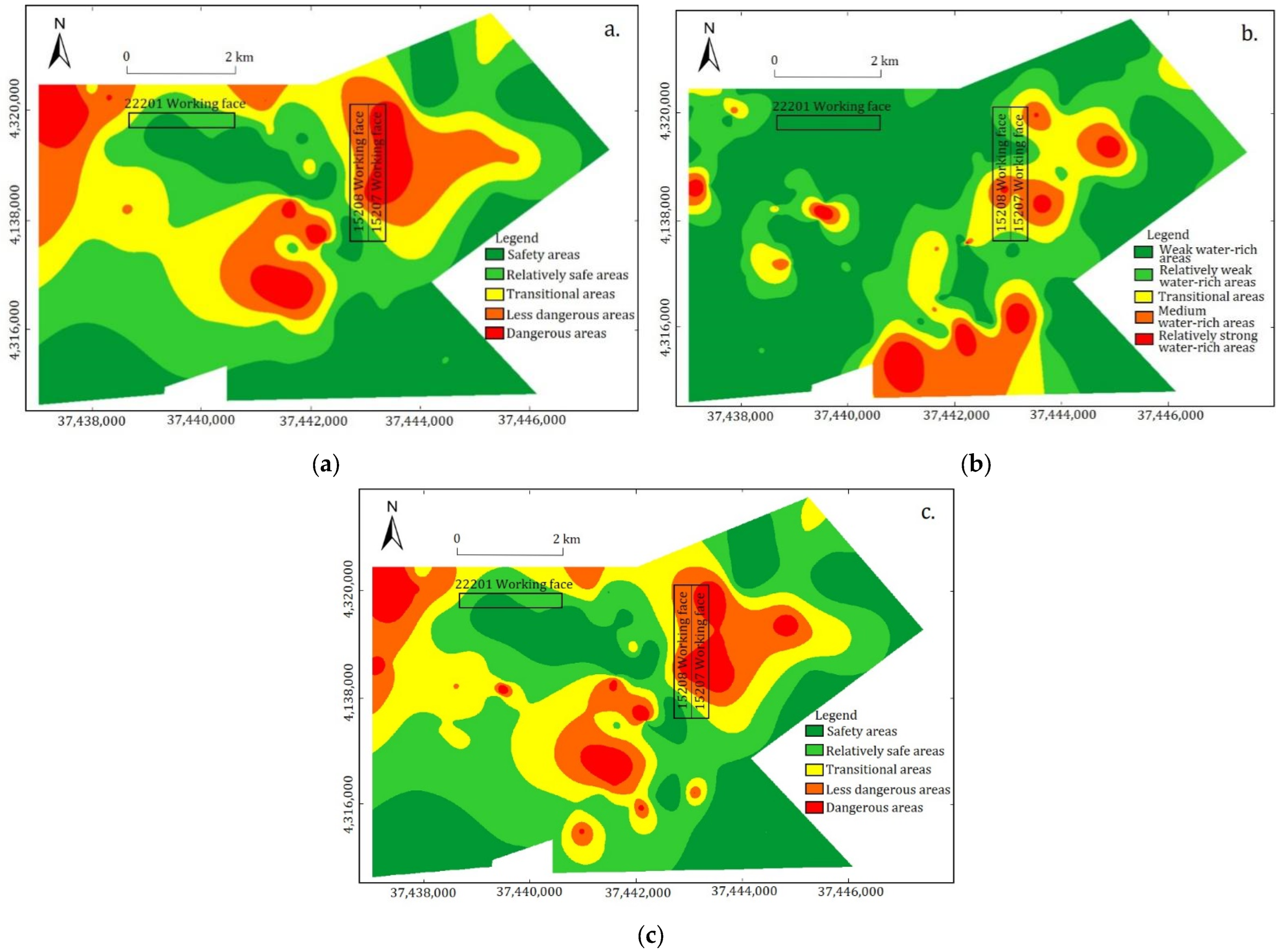
3.3. The Result of Comprehensive Water Inrush Assessment
- Normalize water inrush risk index model Vi to obtain rVi;
- Squared the index (Gi2), because the overall value of the water-rich structure index is too small;
- Add the normalized value rVi to Gi2, and establish the comprehensive risk assessment model of water inrush.
3.4. Discussion
4. Conclusions
- The water inrush risk index was calculated by combining AHP with EM by the moment estimation method, and the water inrush risk index zoning map of the study area was compiled. In addition, the water content of coal seam roof was calculated by the water rich structure index. Finally, the two indexes were weighted to established comprehensive assessment model.
- On the basis of fully studying the geological and hydrogeological conditions of the coal mine, combined with the drilling data, the control factors of the water inrush risk indexes of Dahaize coal mine and Zhangjiamao coal mine were determined.
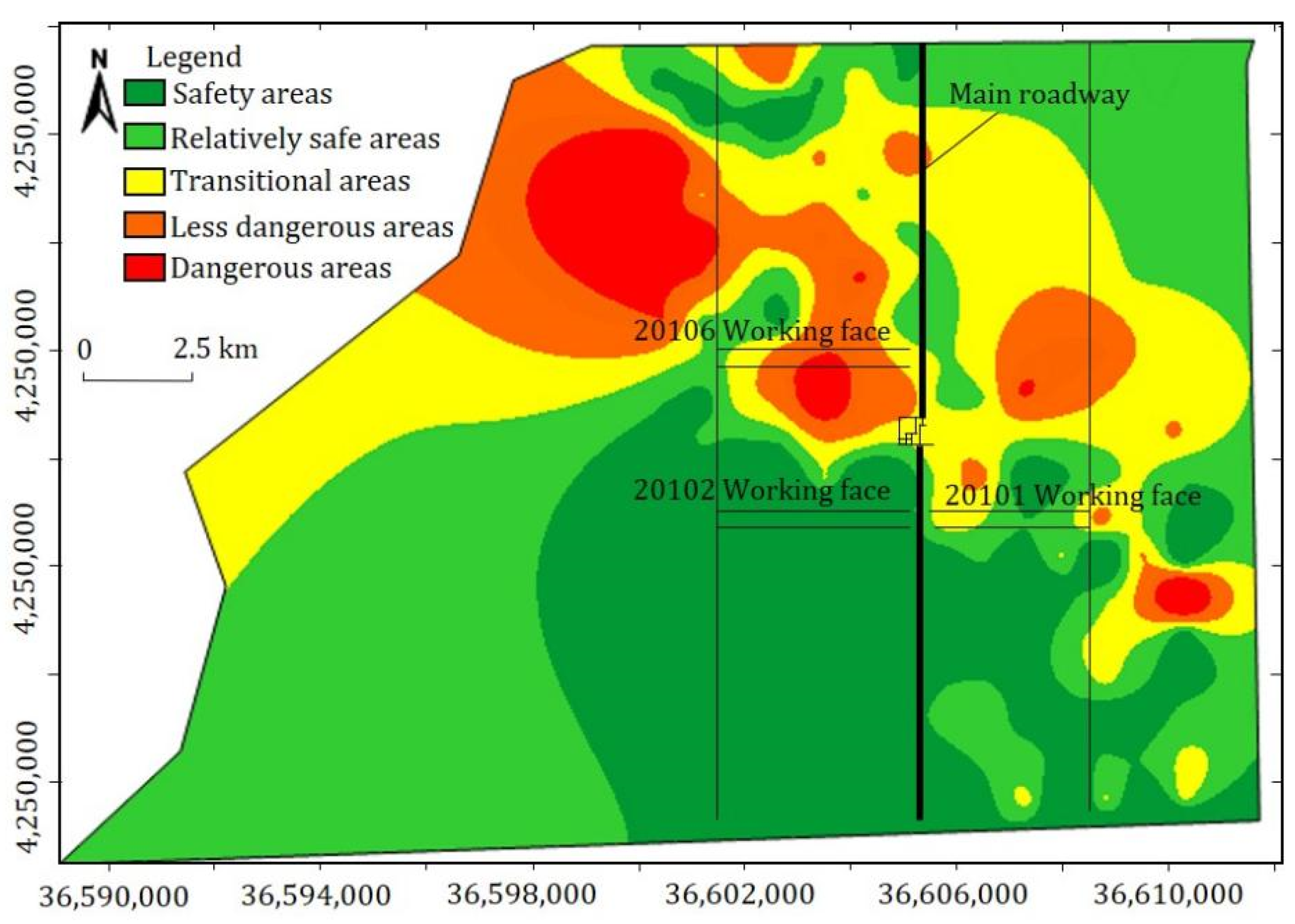
- According to the analysis of the comprehensive water inrush assessment model, the high-risk areas of water inrush were clearly identified. The investigation of the actual mining situation in the mining area showed: the wate inflow in the middle section of the 20106 working face of Dahaize coal mine was relatively large, and the water inflow in the central area of 15207 working face of Zhangjiamao coal mine was large.
- The comprehensive assessment method is consistent with the actual mining status, which shows that this method can be used for the coal mine hydrological assessment with similar geological conditions and demonstrated its reliability and versatility. This method is of great significance for formulating corresponding measures to prevent water inrush in mining areas and ensuring safe production of coal mines.
Author Contributions
Funding
Institutional Review Board Statement
Informed Consent Statement
Data Availability Statement
Conflicts of Interest
References
- Li, P. Mine Water problems and solutions in China. Mine Water Environ. 2018, 37, 217–221. [Google Scholar] [CrossRef] [Scilit]
- Cui, X. Coal mine flood risk analysis based on fuzzy evaluation method. J. Phys. Conf. Ser. 2019, 1176, 42095. [Google Scholar] [CrossRef] [Scilit]
- Yin, H.; Shi, Y.; Niu, H.; Xie, D.; Wei, J.; Lefticariu, L.; Xu, S. A GIS-based model of potential groundwater yield zonation for a sandstone aquifer in the Juye Coalfield, Shangdong, China. J. Hydrol. 2018, 557, 434–447. [Google Scholar] [CrossRef] [Scilit]
- Gu, Q.; Huang, Z.; Li, S.; Zeng, W.; Wu, Y.; Zhao, K. An approach for water-inrush risk assessment of deep coal seam mining: A case study in Xinlongzhuang coal mine. Environ. Sci. Pollut. Res. 2020, 27, 43163–43176. [Google Scholar] [CrossRef] [Scilit] [PubMed]
- Chen, S.L.; Wu, Q.; Zhao, Y.W.; Li, X.Y.; Bian, K.; Zhai, L.J. On 3D numerical simulation model of mine water under condition of dewatering based on mine production schedule. China Coal 2014, 40, 45–49. [Google Scholar]
- Gao, R.; Yan, H.; Ju, F.; Mei, X.; Wang, X. Influential factors and control of water inrush in a coal seam as the main aquifer. Int. J. Min. Sci. Technol. 2018, 28, 187–193. [Google Scholar] [CrossRef] [Scilit]
- Zeng, Y.; Wu, Q.; Liu, S.; Zhai, Y.; Lian, H.; Zhang, W. Evaluation of a coal seam roof water inrush: Case study in the Wangjialing coal mine, China. Mine Water Environ. 2018, 37, 174–184. [Google Scholar] [CrossRef] [Scilit]
- Wu, Q.; Huang, X.L.; Dong, D.L.; Yin, Z.R.; Li, J.M. “Three maps two predictions method to evaluate water bursting conditions on roof coal. J. China Coal Soc. 2000, 62–67. [Google Scholar] [CrossRef]
- Wu, Q.; Liu, Y.; Luo, L.; Liu, S.; Sun, W.; Zeng, Y. Quantitative evaluation and prediction of water inrush vulnerability from aquifers overlying coal seams in Donghuantuo coal mine, China. Environ. Earth Sci. 2015, 74, 1429–1437. [Google Scholar] [CrossRef] [Scilit]
- Nampak, H.; Pradhan, B.; Manap, M.A. Application of GIS based data driven evidential belief function model to predict groundwater potential zonation. J. Hydrol. 2014, 513, 283–300. [Google Scholar] [CrossRef] [Scilit]
- Lee, S.; Kim, Y.; Oh, H. Application of a weights-of-evidence method and GIS to regional groundwater productivity potential mapping. J. Environ. Manag. 2012, 96, 91–105. [Google Scholar] [CrossRef] [Scilit] [PubMed]
- Ruan, Z.; Li, C.; Wu, A.; Wang, Y. A new risk assessment model for underground mine water inrush based on AHP and D–S evidence theory. Mine Water Environ. 2019, 38, 488–496. [Google Scholar] [CrossRef] [Scilit]
- Cheng, X.; Qiao, W.; Li, G.; Yu, Z. Risk assessment of roof water disaster due to multi-seam mining at Wulunshan coal mine in China. Arab. J. Geosci. 2021, 14, 1116. [Google Scholar] [CrossRef] [Scilit]
- Lu, Q.; Li, X.; Li, W.; Chen, W.; Li, L.; Liu, S. Risk evaluation of Bed-Separation water inrush: A case study in the Yangliu coal mine, China. Mine Water Environ. 2018, 37, 288–299. [Google Scholar] [CrossRef] [Scilit]
- Zhang, Q.; Wang, Z. Spatial prediction of loose aquifer water abundance mapping based on a hybrid statistical learning approach. Earth Sci. Inf. 2021, 14, 1349–1365. [Google Scholar] [CrossRef] [Scilit]
- Zhang, W.; Wang, Z.; Zhu, X.; Li, W.; Gao, B.; Yu, H. A risk assessment of a water-Sand Inrush during coal mining under a loose aquifer based on a factor analysis and the Fisher model. J. Hydrol. Eng. 2020, 25, 04020033. [Google Scholar] [CrossRef] [Scilit]
- Bo, L.; Qiang, W.; Xian-qian, D.; Meng-yu, C. Risk analysis model of water inrush through the seam floor based on set pair analysis. Mine Water Environ. 2018, 37, 281–287. [Google Scholar] [CrossRef] [Scilit]
- Han, C.; Xu, J.; Zhang, W.; Wei, J.; Yang, F.; Yin, H.; Xie, D. Assessment and drouting of water inrush induced by Shaft-Freezing holes in the Yingpanhao coal mine, Inner Mongolia, China. Mine Water Environ. 2021, 41, 16–29. [Google Scholar] [CrossRef] [Scilit]
- Yang, W.F.; Xia, X.X.; Pan, B.L.; Gu, C.S.; Yue, J. The fuzzy comprehensive evaluation of water and sand inrush risk during underground mining. J. Intell. Fuzzy Syst. 2016, 30, 2289–2295. [Google Scholar] [CrossRef] [Scilit]
- Zeng, J.; Liu, Q.; Huang, R.; Guan, Y.; Zhang, S. Safety area delimiting of coal mining under thick loosened aquifer with thin bedrock based on unascertained measure theory. J. Min. Saf. Eng. 2015, 32, 898–904. [Google Scholar] [CrossRef]
- Wang, J.; Jin, P.; Bishop, P.L.; Li, F. Upgrade of three municipal wastewater treatment lagoons using a high surface area media. Front. Environ. Sci. Eng. 2012, 6, 288–293. [Google Scholar] [CrossRef] [Scilit]
- Lan, H.Q.; Xia, X.X.; Ran, W.; Yan, T. Possibility analysis of water and sand inrush at shallow buried coal seam with unconsolidated formation and thin bedrock. Saf. Coal Mines 2015, 46, 168–171. [Google Scholar]
- Gao, R.J.; Ji, T.D.; Yu, C. Mine water inflow prediction and effect evaluation based on fused drilling-geophysical data. Saf. Coal Mines 2021, 52, 9–17. [Google Scholar]
- Bo, L.; Chen, Y. Risk assessment of coal floor water inrush from underlying aquifers based on GRA-AHP and its application. Geotech. Geol. Eng. 2016, 34, 143–154. [Google Scholar]
- Saaty, T.L. A scaling method for priorities in hierarchical structures. J. Math Psychol. 2000, 15, 234–281. [Google Scholar] [CrossRef] [Scilit]
- Li, Q.; Sui, W. Risk evaluation of mine-water inrush based on principal component logistic regression analysis and an improved analytic hierarchy process. Hydrogeol. J. 2021, 29, 1299–1311. [Google Scholar] [CrossRef] [Scilit]
- Paraskevis, N.; Roumpos, C.; Stathopoulos, N.; Adam, A. Spatial analysis and evaluation of a coal deposit by coupling AHP & GIS techniques. Int. J. Min. Sci. Technol. 2019, 29, 943–953. [Google Scholar]
- Sridhar, P.; Ganapuram, S. Morphometric analysis using fuzzy analytical hierarchy process (FAHP) and geographic information systems (GIS) for the prioritization of watersheds. Arab. J. Geosci. 2021, 14, 236. [Google Scholar] [CrossRef] [Scilit]
- Li, P.; Hui, Q.; Wu, J. Application of set pair analysis method based on entropy weight in groundwater quality assessment -A case study in Dongsheng city, Northwest China. E-J. Chem. 2011, 8, 851–858. [Google Scholar]
- Wu, J.; Li, P.; Qian, H.; Chen, J. On the sensitivity of entropy weight to sample statistics in assessing water quality: Statistical analysis based on large stochastic samples. Environ. Earth Sci. 2015, 74, 2185–2195. [Google Scholar] [CrossRef] [Scilit]
- Hu, X.J.; Li, W.P.; Cao, D.T.; Liu, M.C. Index of multiple factors and expected height of fully mechanized water flowing fractured zone. J. China Coal Soc. 2012, 37, 613–620. [Google Scholar]
- Zhou, X.; Ouyang, Z.; Zhou, R.; Ji, Z.; Yi, H.; Tang, Z.; Chang, B.; Yang, C.; Sun, B. An approach to dynamic disaster prevention in strong rock burst coal seam under Multi—Aquifers: A case study of Tingnan coal mine. Energies 2021, 14, 7287. [Google Scholar] [CrossRef] [Scilit]





| Factor | K1 | K2 | K3 | K4 | K5 |
|---|---|---|---|---|---|
| K1 | 1 | 1/4 | 2 | 1/3 | 1/4 |
| K2 | 4 | 1 | 3 | 2 | 1/2 |
| K3 | 1/2 | 1/3 | 1 | 1/2 | 1/3 |
| K4 | 3 | 1/2 | 2 | 1 | 1/2 |
| K5 | 4 | 2 | 3 | 2 | 1 |
| Weight | K1 | K2 | K3 | K4 | K5 |
|---|---|---|---|---|---|
| AHP (qi) | 0.0923 | 0.2770 | 0.0835 | 0.1818 | 0.3654 |
| EM (ui) | 0.0725 | 0.2244 | 0.1477 | 0.2235 | 0.3319 |
| AHP-EM (ωi) | 0.0821 | 0.2502 | 0.1163 | 0.2031 | 0.3483 |
| Weight | Z1 | Z2 | Z3 | Z4 | Z5 |
|---|---|---|---|---|---|
| AHP (qi) | 0.375 | 0.125 | 0.250 | 0.125 | 0.125 |
| EM (ui) | 0.299 | 0.298 | 0.141 | 0.010 | 0.252 |
| AHP-EM (ωi) | 0.341 | 0.203 | 0.201 | 0.073 | 0.182 |
Publisher’s Note: MDPI stays neutral with regard to jurisdictional claims in published maps and institutional affiliations. |
© 2022 by the authors. Licensee MDPI, Basel, Switzerland. This article is an open access article distributed under the terms and conditions of the Creative Commons Attribution (CC BY) license (https://creativecommons.org/licenses/by/4.0/).
Share and Cite
Sun, Z.; Bao, W.; Li, M. Comprehensive Water Inrush Risk Assessment Method for Coal Seam Roof. Sustainability 2022, 14, 10475. https://doi.org/10.3390/su141710475
Sun Z, Bao W, Li M. Comprehensive Water Inrush Risk Assessment Method for Coal Seam Roof. Sustainability. 2022; 14(17):10475. https://doi.org/10.3390/su141710475
Chicago/Turabian StyleSun, Zhenming, Wenpeng Bao, and Mei Li. 2022. "Comprehensive Water Inrush Risk Assessment Method for Coal Seam Roof" Sustainability 14, no. 17: 10475. https://doi.org/10.3390/su141710475
APA StyleSun, Z., Bao, W., & Li, M. (2022). Comprehensive Water Inrush Risk Assessment Method for Coal Seam Roof. Sustainability, 14(17), 10475. https://doi.org/10.3390/su141710475