
Comprehensive Assessment of Geopolitical Risk in the Himalayan Region Based on the Grid Scale


Abstract
:1. Introduction
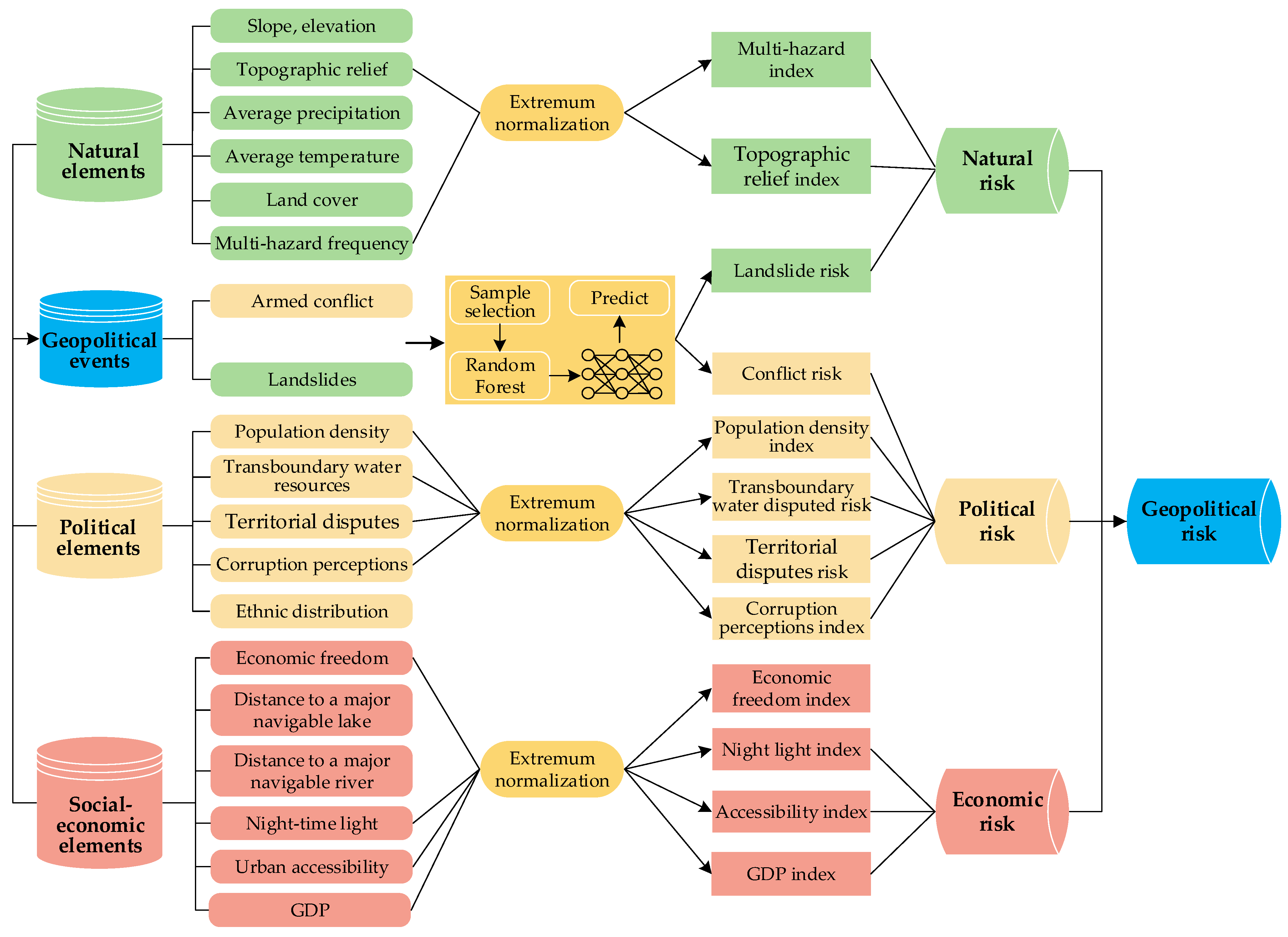
2. Analytical Framework
3. Materials and Methods
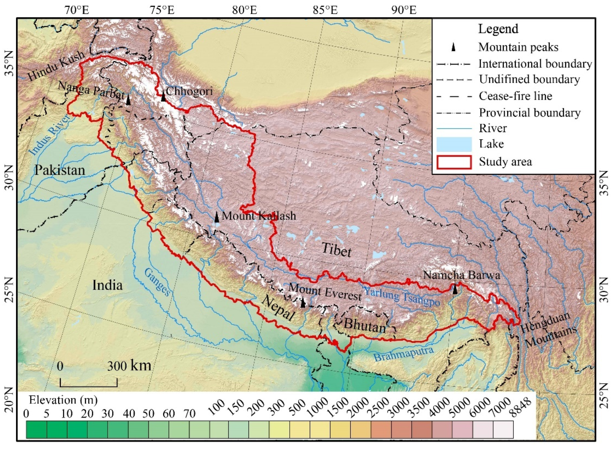
3.1. Study Area
3.2. Data Sources and Processing
3.2.1. Data Sources
- (1)
- Geopolitical event data
- (2)
- Natural element data
- (3)
- Social-economic and political element data
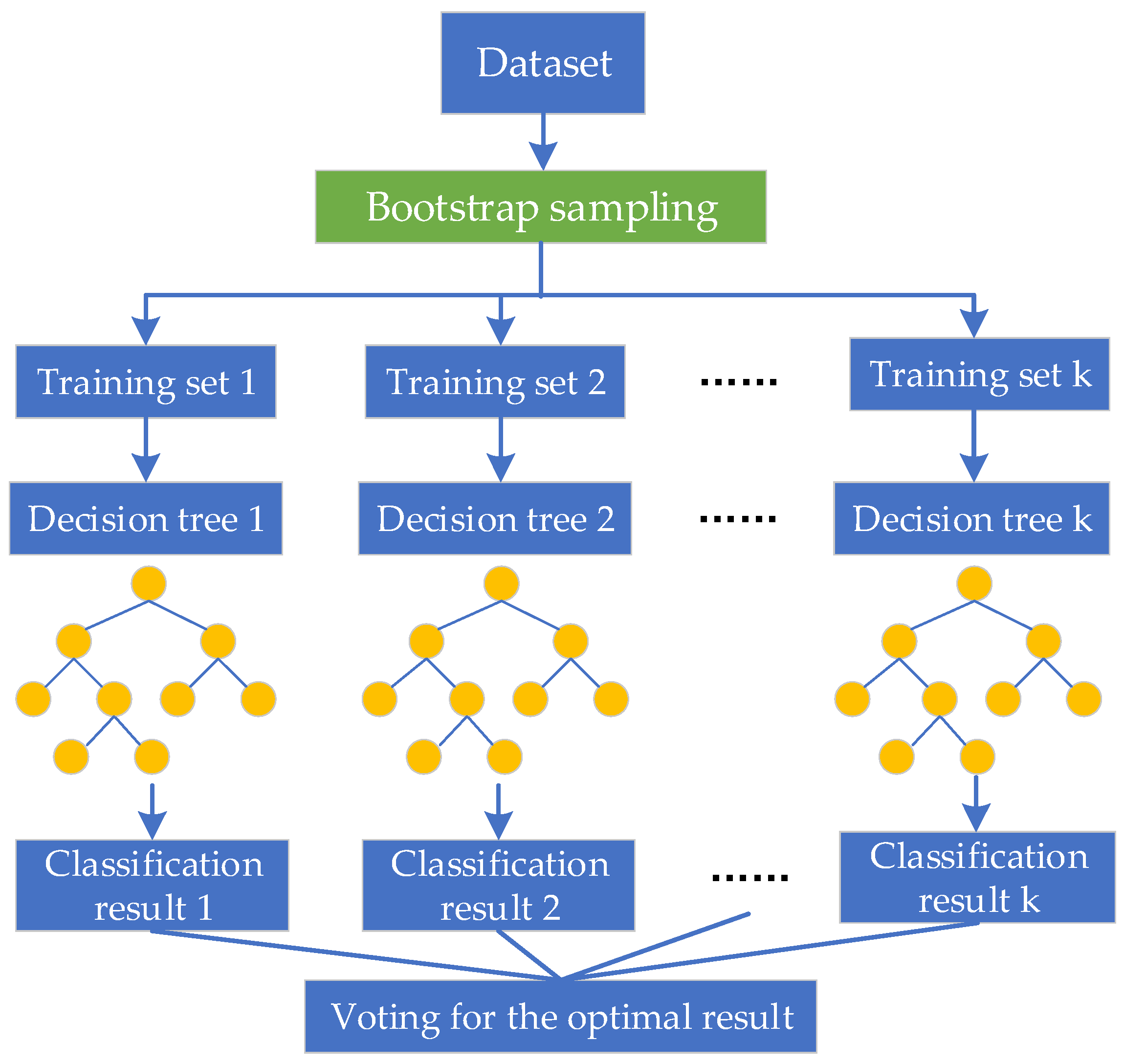
3.2.2. Data Processing
- (1)
- RF model
- (2)
- Extremum normalization
3.3. Methods
3.3.1. Weight Determination
- (1)
- Analytic hierarchy process method
- (2)
- Entropy weight method
- (3)
- Linear combination weighting
3.3.2. Composite Index Measurement
4. Results
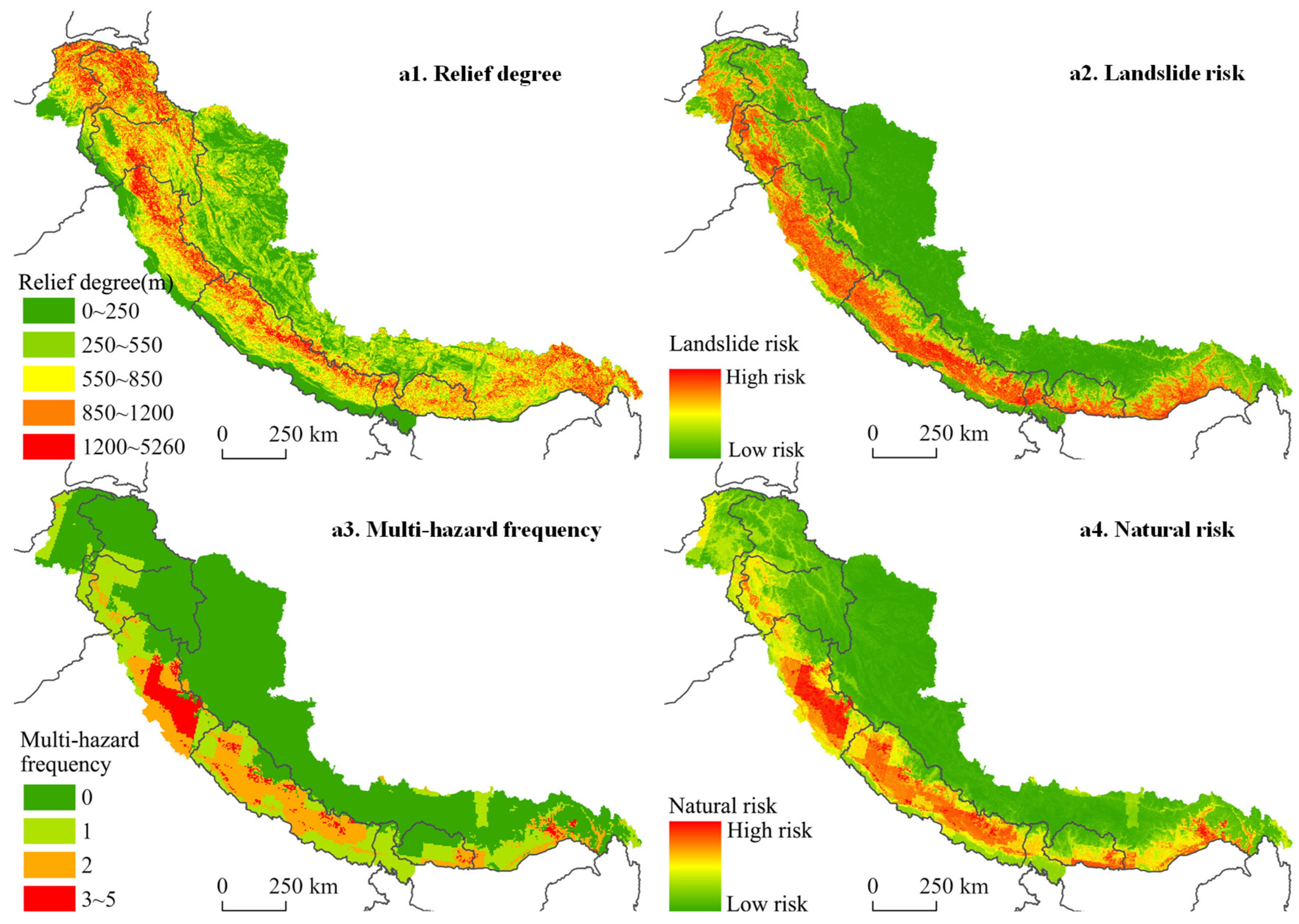
4.1. Natural Risk
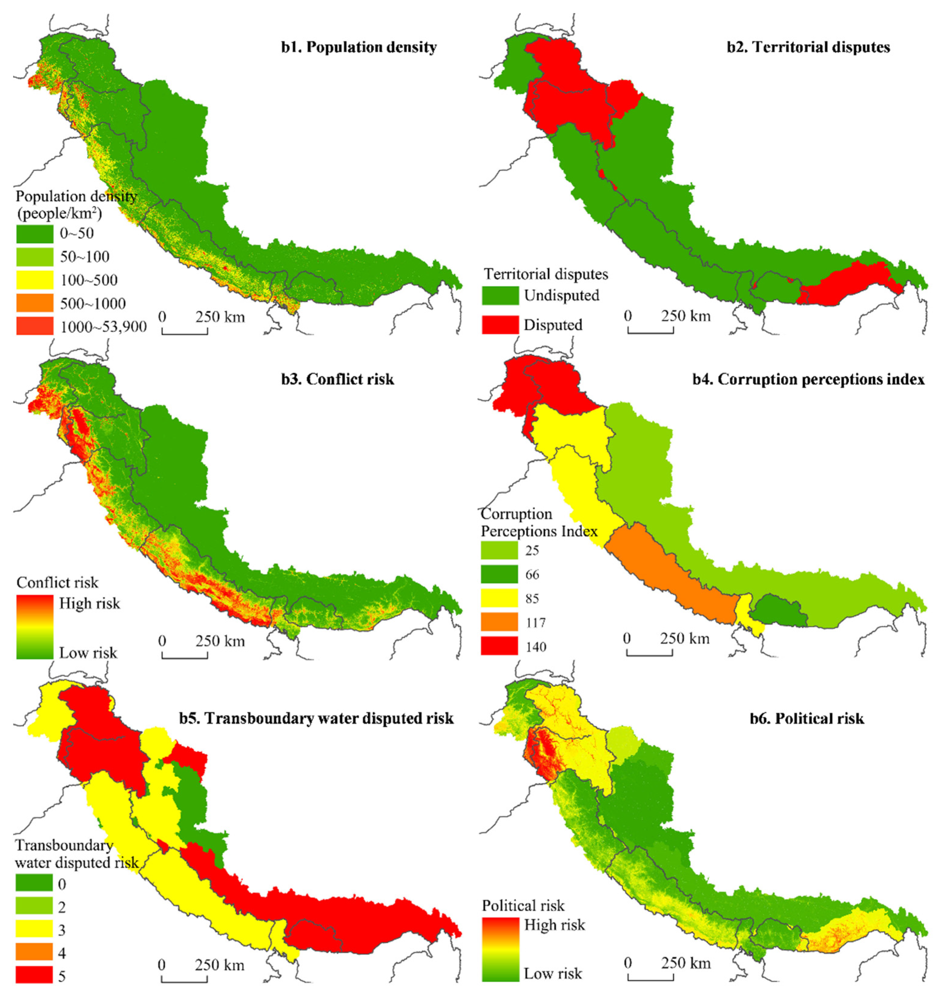
4.2. Political Risk
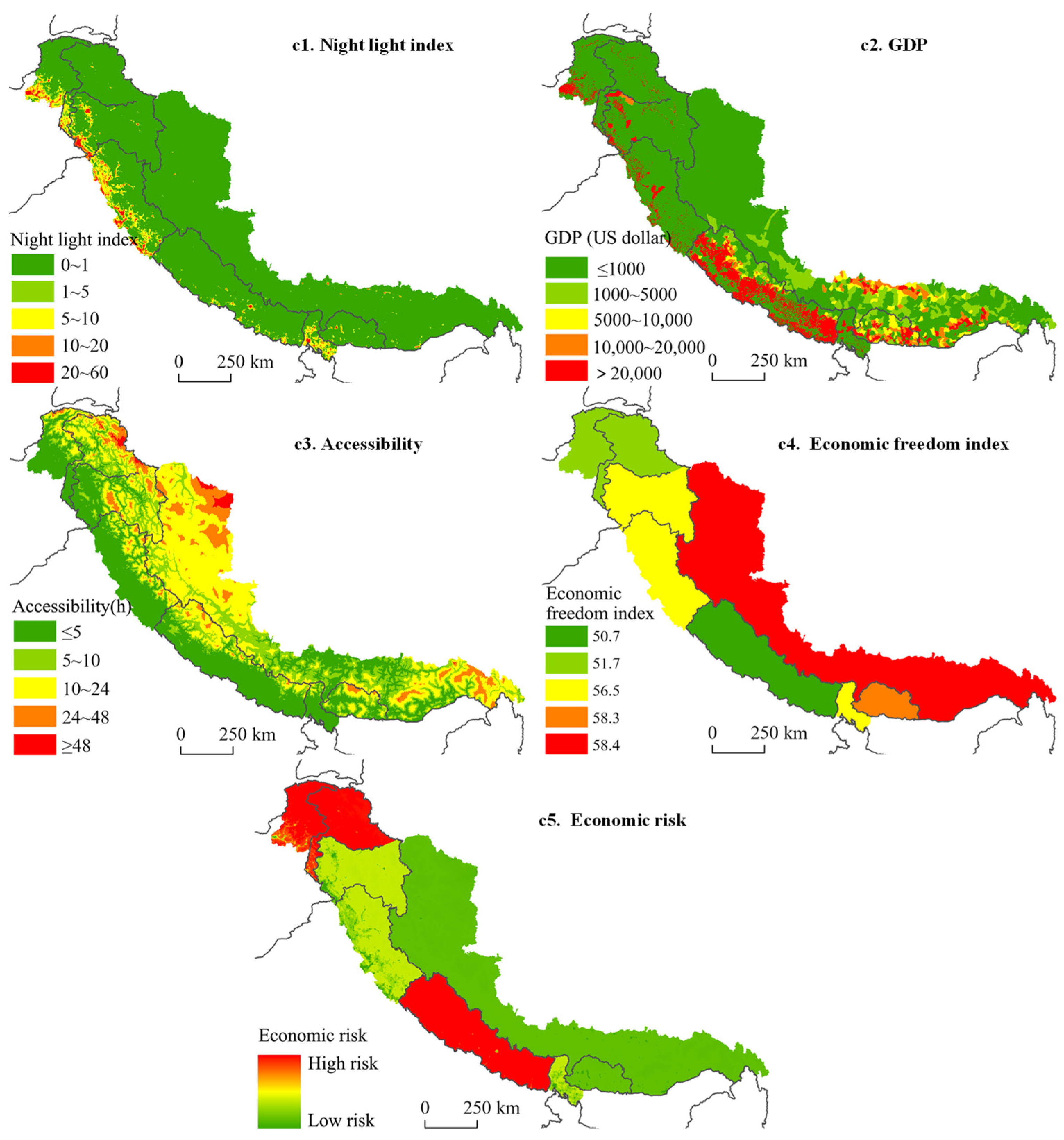
4.3. Economic Risk
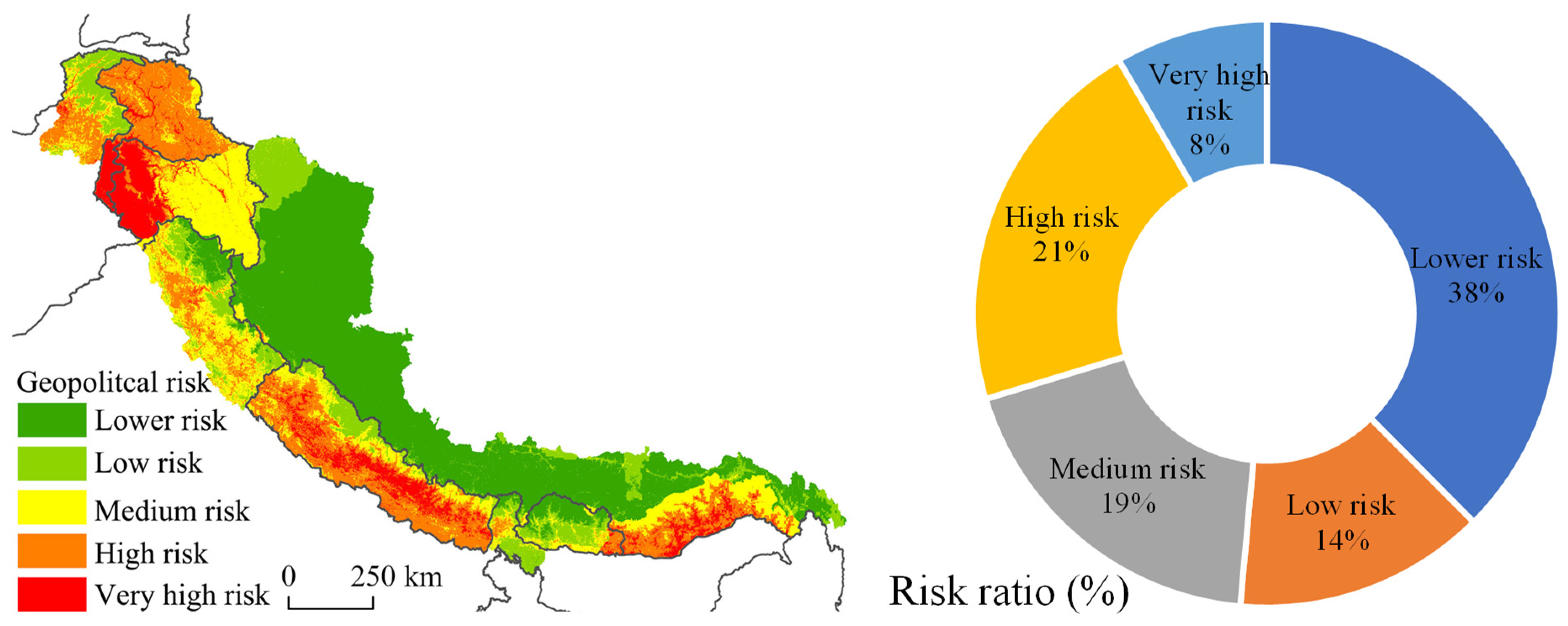
4.4. Geopolitical Risk
5. Discussion
6. Conclusions
- (1)
- The geopolitical risk in the Himalayan region as a whole showed a medium-high risk zone on the southern slopes of the Himalayas and a low-risk zone on the northern slopes.
- (2)
- The geopolitical risks in the Himalayan region are influenced by a combination of natural, political, and economic risks. High risks of natural risks are concentrated in the Indian states of Himachal Pradesh and Uttarakhand, Nepal, southern Tibet, and southeastern Bhutan. High risks of political risks are concentrated in the Kashmir Valley and areas south of it, and medium risks are concentrated in Kashmir and southern Tibet. High risks of economic risks are concentrated in the Khyber-Pakhtunkhwa of Pakistan, Pakistani-controlled Kashmir, and Nepal.
- (3)
- Raster-scale assessments can better characterize the spatial distribution of geopolitical risk and provide a basis for the restoration and construction of traditional trade routes in the Himalayan region.
- (4)
- Given that China’s investment and corridor construction in the Himalayan region are mainly concentrated in Nepal and Kashmir, which are mainly high-risk and very high-risk areas, a comprehensive study of risks is needed for future investment, planning, and construction. Priority should be given to the construction of relatively low-risk areas in northern Nepal near Burang County and Mustang. Based on the low-risk level in Bhutan, there is a need for integrated planning for the rehabilitation and construction of corridors between China and Bhutan. Further detailed analysis of the geopolitical risk of each traditional trade route in the Himalayan region in conjunction with field surveys should be done to identify the main constraints of the corridors and propose strategies for their construction and control.
Author Contributions
Funding
Institutional Review Board Statement
Informed Consent Statement
Data Availability Statement
Acknowledgments
Conflicts of Interest
References
- Hu, Z.; Wang, X. Temporal and spatial evolution characteristics and laws of geostrategic intersections in great powers. Trop. Geogr. 2019, 39, 833–843. (In Chinese) [Google Scholar]
- Wu, S.; Yan, J. Progress and prospect of shatter belt research. Prog. Geogr. 2022, 41, 1109–1122. (In Chinese) [Google Scholar] [CrossRef]
- Hong, J.; Luo, H.; Liang, M.; Zhu, R. Study on the geopolitical risks of major projects of ‘the Belt and Road Initiative’. Hum. Geogr. 2018, 33, 130–136. (In Chinese) [Google Scholar]
- Xiong, C.; Wang, L.; Qu, Q.; Xiang, N.; Wang, B. Progress and prospect of geopolitical risk research. Prog. Geogr. 2020, 39, 695–706. (In Chinese) [Google Scholar] [CrossRef]
- Ge, Q.; Jiang, D.; Lu, F.; Deng, X.; Wang, S. Spatio-temporal simulation of the geopolitical environment system. J. Geogr. Sci. 2018, 28, 871–880. [Google Scholar] [CrossRef] [Green Version]
- Ge, Q.; He, F.; Liu, H. Analysis of historical change of boundary of Yadong area in Tibet, China and its geostrategy. Bull. Chin. Acad. Sci. 2017, 32, 993–1002. (In Chinese) [Google Scholar]
- Wu, S.; Yan, J.; Zhang, Y.; Peng, T.; Su, K. Exploring the evolution process and driving mechanism of traditional trade routes in Himalayan region. Acta Geogr. Sin. 2021, 76, 2157–2173. (In Chinese) [Google Scholar]
- Yang, M. Study of the “Trans-Himalayan Economic Zone of Cooperation” based on the perspective of border effects. West. China Dev. Rev. 2015, 62–73. Available online: https://www.cnki.com.cn/Article/CJFDTotal-XBLT201500007.htm (accessed on 16 April 2022). (In Chinese).
- Kobrin, S.J. Political risk: A review and reconsideration. J. Int. Bus. Stud. 1979, 10, 67–80. [Google Scholar] [CrossRef]
- Bremer, L.P. Geopolitical risk assessment in times of turmoil. Tulsa J. Comp. Int. Law 1996, 4, 117–125. [Google Scholar]
- Simon, J.D. Political risk assessment: Past trends and future prospects. Columbia J. World Bus. 1982, 17, 62–71. [Google Scholar]
- Agarwal, J.; Feils, D. Political risk and the internationalization of firms: An empirical study of Canadian-based export and FDI firms. Can. J. Adm. Sci. 2007, 24, 165–181. [Google Scholar] [CrossRef]
- Hendrix, C.S. Keeping Up with the Future: Upgrading Forecasts of Political Instability and Geopolitical Risk. Policy Briefs PB19-10. Peterson Institute for International Economics: Washington, DC, USA, 2019. [Google Scholar]
- Caldara, D.; Iacoviello, M. Measuring Geopolitical Risk. Am. Econ. Rev. 2022, 112, 1194–1225. [Google Scholar] [CrossRef]
- Engle, R.F.; Campos-Martins, S. Measuring and hedging geopolitical risk. NYU Stern Sch. Bus. Forthcom. 2020. Available online: https://ssrn.com/abstract=3685213 (accessed on 8 April 2022). [CrossRef]
- Munoz, B.; Garcia-Verdugo, J.; San-Martin, E. Quantifying the geopolitical dimension of energy risks: A tool for energy modelling and planning. Energy 2015, 82, 479–500. [Google Scholar] [CrossRef]
- Kamenopoulos, S.N.; Agioutantis, Z. Geopolitical risk assessment of countries with rare earth element deposits. Min. Metall. Explor. 2020, 37, 51–63. [Google Scholar] [CrossRef]
- Habib, K.; Hamelin, L.; Wenzel, H. A dynamic perspective of the geopolitical supply risk of metals. J. Clean. Prod. 2016, 133, 850–858. [Google Scholar] [CrossRef]
- Yang, Y.; He, Z. China’s overseas oil and gas dependence: Situation, geographical risks, and countermeasures. Resour. Sci. 2020, 42, 1614–1629. (In Chinese) [Google Scholar] [CrossRef]
- Xiao, F.; Zhang, X. The geopolitical risks and solutions for China’s railway construction in Africa. J. Int. Relat. 2020, 39–67. Available online: http://www.nssd.cn/articles/Article_Read.aspx?id=7102507948&from=Qikan_Article_Detail (accessed on 15 April 2022). (In Chinese).
- Chen, L. Research on the Georisk of China’s Foreign Project Contracting. Master’s Thesis, Jinan University, Guangzhou, China, 2018. [Google Scholar]
- Xi, D.; Liu, J.; Zhou, Q.; Han, Z. Geopolitical risks for the One Belt and One Road construction in Indian Ocean Region. World Reg. Stud. 2018, 27, 14–23. (In Chinese) [Google Scholar]
- Zhang, X.; Xu, Z. BRI projects’ geopolitical risks: Concepts and theorization. Glob. Rev. 2020, 12, 80–96. (In Chinese) [Google Scholar]
- Zhang, F.; Liu, H.; Song, T.; Yeerken, W. Assessment and mechanism analysis of the geo-integrated risk of Indochina Peninsula. World Reg. Stud. 2021, 30, 1151–1162. (In Chinese) [Google Scholar]
- Chen, X.; Cheng, S.; Wu, L. Quantitative measurement and evaluation of geopolitical risks confronting Central Asian major energy exporting countries. Resour. Sci. 2018, 40, 773–783. (In Chinese) [Google Scholar]
- Shen, Y.; Luo, H.; Hong, J.; Liang, M.; Ye, S. Spatial differentiation pattern and driving factors of geo-risk in Latin America based on the “Belt and Road” initiative. Trop. Geogr. 2021, 41, 1222–1235. (In Chinese) [Google Scholar]
- Han, Q.; Jiang, D.; Fu, J.; Lin, G. On the risk index of energy resources investment in sub-Saharan Africa along “the Belt and Road Initiative”. Sci. Technol. Rev. 2018, 36, 108–116. (In Chinese) [Google Scholar]
- Dong, D.; Li, Z.; Fu, J.; Lin, G. Analysis of forest resources investment risk in sub-Saharan Africa. Sci. Technol. Rev. 2018, 36, 100–107. (In Chinese) [Google Scholar]
- Yang, W.; Tu, J. Evaluating geo-strategic risks on CPEC. South Asian Stud. Q. 2018, 1, 76–85. (In Chinese) [Google Scholar]
- Li, Z. Research on index of arctic route geopolitical safety. Comput. Eng. Appl. 2011, 47, 237–241. (In Chinese) [Google Scholar]
- Lin, G.; Ding, F.; Fu, J.; Yang, X.; Han, Q. Intelligent recognition of risk levels of geopolitical system for South Asia. Sci. Technol. Rev. 2018, 36, 70–74. (In Chinese) [Google Scholar]
- Country-Risk Rating Team of the National Institute for Global Strategy, Chinese Academy of Social Sciences; Division of International Investment of the Institute of World Economics and Politics of Chinese Academy of Social Sciences. Report of Country-Risk Rating of Overseas Investment from China(2021); China Social Sciences Press: Beijing, China, 2021. [Google Scholar]
- Jiang, D.; Wang, Q.; Ding, F. Research on the geo-environment in the era of big data. Sci. Technol. Rev. 2018, 36, 41–48. (In Chinese) [Google Scholar]
- Birkmann, J. Risk. In Encyclopedia of Natural Hazards; Bobrowsky, P.T., Ed.; Springer: Dordrecht, The Netherlands, 2013; pp. 856–862. [Google Scholar]
- Lemos, F. On the definition of risk. J. Risk Manag. Financ. Inst. 2020, 13, 266–278. [Google Scholar]
- Reisinger, A.; Howden, M.; Vera, C.; Garschagen, M.; Hurlbert, M.; Kreibiehl, S.; Mach, K.J.; Mintenbeck, K.; O’Neill, B.; Pathak, M.; et al. The Concept of Risk in the Ipcc Sixth Assessment Report: A Summary of Cross-Working Group Discussions. 2020. Available online: https://www.ipcc.ch/site/assets/uploads/2021/01/The-concept-of-risk-in-the-IPCC-Sixth-Assessment-Report.pdf (accessed on 10 May 2022).
- Bohl, D.; Hanna, T.; Mapes, B.R.; Moyer, J.D.; Narayan, K.; Wasif, K. Understanding and forecasting geopolitical risk and benefits. Denver CO Zur. Insur. Group Atl. Counc. 2017. Available online: https://ssrn.com/abstract=3941439 (accessed on 1 May 2022). [CrossRef]
- Xu, J.; Wang, Z.; Shen, F.; Quyang, C.; Tu, Y. Natural disasters and social conflict: A systematic literature review. Int. J. Disaster Risk Reduct. 2016, 17, 38–48. [Google Scholar] [CrossRef]
- Nel, P.; Righarts, M. Natural disasters and the risk of violent civil conflict. Int. Stud. Q. 2008, 52, 159–185. [Google Scholar] [CrossRef]
- Busse, M.; Hefeker, C. Political risk, institutions and foreign direct investment. Eur. J. Political Econ. 2007, 23, 397–415. [Google Scholar] [CrossRef] [Green Version]
- Chen, S. Profiting from FDI in conflict zones. J. World Bus. 2017, 52, 760–768. [Google Scholar] [CrossRef]
- Reynal-Querol, M. Ethnic and Religious Conflicts, Political Systems and Growth. Ph.D. Thesis, London School of Economics and Political Science (University of London), London, UK, 2001. [Google Scholar]
- Liu, W.; Zhou, Y. Index development for geopolitical risks and international comparison. Area Stud. Glob. Dev. 2018, 2, 5–29. (In Chinese) [Google Scholar]
- Asamoah, M.E.; Adjasi, C.K.D.; Alhassan, A.L. Macroeconomic uncertainty, foreign direct investment and institutional quality: Evidence from Sub-Saharan Africa. Econ. Syst. 2016, 40, 612–621. [Google Scholar] [CrossRef]
- Caetano, J.; Caleiro, A. Economic freedom and foreign direct investment: How different are the MENA countries from the EU. iBusiness 2009, 1, 65–74. [Google Scholar] [CrossRef] [Green Version]
- Raleigh, C.; Urdal, H. Climate change, environmental degradation and armed conflict. Political Geogr. 2007, 26, 674–694. [Google Scholar] [CrossRef]
- Hao, M.; Fu, J.; Jiang, D.; Ding, F.; Chen, S. Simulating the linkages between economy and armed conflict in India with a long short-term memory algorithm. Risk Anal. 2020, 40, 1139–1150. [Google Scholar] [CrossRef]
- Nie, Y.; Pritchard, H.D.; Liu, Q.; Hennig, T.; Wang, W.; Wang, X.; Liu, S.; Nepal, S.; Samyn, D.; Hewitt, K.; et al. Glacial change and hydrological implications in the Himalaya and Karakoram. Nat. Rev. Earth Environ. 2021, 2, 91–106. [Google Scholar] [CrossRef]
- Xu, X. Tribute System and Colonial System. Ph.D. Thesis, Party School of the Central Committee of CPC, Beijing, China, 2019. [Google Scholar]
- Liu, J. Research on Regional Economic Cooperation around the Himalayas in the New Era. Ph.D. Thesis, Shanghai Academy of Social Sciences, Shanghai, China, 2019. [Google Scholar]
- Mao, X.; Liu, X.; Zhang, G. Taxonomic revision of Adiantum ser. Venusta Ching (Pteridaceae) from Pan-Himalayas. Plant Divers. Resour. 2014, 36, 453–467. (In Chinese) [Google Scholar]
- Wester, P.; Mishra, A.; Mukherji, A.; Shrestha, A.B. The Hindu Kush Himalaya Assessment: Mountains, Climate Change, Sustainability and People; Springer International Publishing: Cham, Switzerland, 2019. [Google Scholar]
- Wang, S.; Qin, D.; Xiao, C. Moraine-dammed lake distribution and outburst flood risk in the Chinese Himalaya. J. Glaciol. 2015, 61, 115–126. [Google Scholar]
- Rusk, J.; Maharjan, A.; Tiwari, P.; Chen, T.H.K.; Shneiderman, S.; Turin, M.; Seto, K.C. Multi-hazard susceptibility and exposure assessment of the Hindu Kush Himalaya. Sci. Total Environ. 2022, 804, 150039. [Google Scholar] [CrossRef]
- Zurick, D. Illustrated Atlas of the Himalaya; The University Press of Kentucky: Lexington, MA, USA, 2006. [Google Scholar]
- Du, D.; Liu, C.; Hu, Z.; Ma, Y. The impact of “Asian Water Tower” change on the geopolitical environment around China. World Reg. Stud. 2020, 29, 223–231. (In Chinese) [Google Scholar]
- Kirschbaum, D.; Stanley, T.; Zhou, Y. Spatial and temporal analysis of a global landslide catalog. Geomorphology 2015, 249, 4–15. [Google Scholar] [CrossRef]
- Feng, Z.; Li, W.; Li, P.; Xiao, C. Relief degree of land surface and its geographical meanings in the Qinghai-Tibet Plateau, China. Acta Geogr. Sin. 2020, 75, 1359–1372. (In Chinese) [Google Scholar]
- Kummu, M.; Taka, M.; Guillaume, J.H.A. Gridded global datasets for gross domestic product and human development index over 1990–2015. Sci. Data 2018, 5, 180004. [Google Scholar] [CrossRef] [Green Version]
- Weiss, D.J.; Nelson, A.; Gibson, H.S.; Temperley, W.; Peedell, S.; Lieber, A.; Hancher, M.; Poyart, E.; Belchior, S.; Fullman, N.; et al. A global map of travel time to cities to assess inequalities in accessibility in 2015. Nature 2018, 553, 333–336. [Google Scholar] [CrossRef]
- China-India Border Self-Defense and Counterattack Combat History Writing Group. Combat History of Self-Defense Counterattack on the Sino-Indian Border; Military Science Publishing House: Beijing, China, 1993. [Google Scholar]
- Tibet Autonomous Region Surveying and Mapping Compilation Committee. Surveying and Mapping Records of Tibet Autonomous Region; China Tibetology Press: Beijing, China, 2009; pp. 326–330. [Google Scholar]
- Breiman, L. Random forests. Mach. Learn. 2001, 45, 5–32. [Google Scholar] [CrossRef] [Green Version]
- Fang, K.; Wu, J.; Zhu, J.; Xie, B. A review of technologies on random forests. Stat. Inf. Forum. 2011, 26, 32–38. (In Chinese) [Google Scholar]
- Huang, P.; Peng, L.; Pan, H. Linking the random forests model and GIS to assess geo-hazards risk: A case study in shifang county, China. IEEE Access 2020, 8, 28033–28042. [Google Scholar] [CrossRef]
- Wang, Z.; Lai, C.; Chen, X.; Yang, B.; Zhao, S.; Bai, X. Flood hazard risk assessment model based on random forest. J. Hydrol. 2015, 527, 1130–1141. [Google Scholar] [CrossRef]
- Zhang, K.; Wu, X.; Niu, R.; Yang, K.; Zhao, L. The assessment of landslide susceptibility mapping using random forest and decision tree methods in the Three Gorges Reservoir area, China. Environ. Earth Sci. 2017, 76, 405. [Google Scholar] [CrossRef]
- Hao, M.; Jiang, D.; Ding, F.; Fu, J.; Chen, S. Simulating spatio-temporal patterns of terrorism incidents on the Indochina Peninsula with GIS and the random forest method. ISPRS Int. J. Geo-Inf. 2019, 8, 133. [Google Scholar] [CrossRef] [Green Version]
- Bradley, A.P. The use of the area under the ROC curve in the evaluation of machine learning algorithms. Pattern Recognit. 1997, 30, 1145–1159. [Google Scholar] [CrossRef] [Green Version]
- Feng, Y.; Wu, S.; Wu, P.; Su, S.; Weng, M.; Bian, M. Spatiotemporal characterization of megaregional poly-centrality: Evidence for new urban hypotheses and implications for polycentric policies. Land Use Policy 2018, 77, 712–731. [Google Scholar] [CrossRef]
- Saaty, T.L.; Vargas, L.G. Models, Methods, Concepts and Applications of the Analytic Hierarchy Process; Springer: New York, NY, USA, 2001. [Google Scholar]
- Zahedi, F. The analytic hierarchy process: A survey of the method and its applications. Interfaces 1986, 16, 96–108. [Google Scholar] [CrossRef]
- Vaidya, O.S.; Kumar, S. Analytic hierarchy process: An overview of applications. Eur. J. Oper. Res. 2006, 169, 1–29. [Google Scholar] [CrossRef]
- Zhu, Y.; Tian, D.; Yan, F. Effectiveness of entropy weight method in decision-making. Math. Probl. Eng. 2020, 2020, 3564835. [Google Scholar] [CrossRef]
- Liu, Y.; Wang, S.; Wang, X.; Jiang, D.; Ravindranath, N.H.; Rahman, A.; Htwe, N.M.; Vijitpan, T. Flood risk assessment in Bangladesh, India and Myanmar based on the AHP weight method and entropy weight method. Geogr. Res. 2020, 39, 1892–1906. (In Chinese) [Google Scholar]
- Shen, S.; Song, C.; Cheng, C.; Gao, J.; Ye, S. GDELT: Big event data for sensing global social dynamics. World Reg. Stud. 2020, 29, 71–76. (In Chinese) [Google Scholar]
- Chen, X.; Yuan, L.; Shen, S.; Liang, X.; Wang, Y.; Wang, X.; Ye, S.; Cheng, C.; Song, C. Analysis of the geo-relationships between China and its neighboring countries. Acta Geogr. Sin. 2019, 74, 1534–1547. (In Chinese) [Google Scholar]
- Sun, X.; Gao, J.; Liu, B.; Wang, Z. Big data-based assessment of political risk along the belt and road. Sustainability 2021, 13, 3935. [Google Scholar] [CrossRef]
- Hammond, J.; Weidmann, N.B. Using machine-coded event data for the micro-level study of political violence. Res. Politics 2014, 1, 1–8. [Google Scholar] [CrossRef] [Green Version]


| Subsystem Level | Index Hierarchy | Weight | ||
|---|---|---|---|---|
| AHP | Entropy Weight | AHP-Entropy Weight Method | ||
| Economic risk (0.2424) | Economic freedom | 0.1344 | 0.9971 | 0.2523 |
| GDP index | 0.4621 | 0.0001 | 0.3989 | |
| Night light index | 0.3008 | 0.0026 | 0.2601 | |
| Accessibility index | 0.1027 | 0.0002 | 0.0887 | |
| Political risk (0.4735) | Population density index | 0.0367 | 0.5809 | 0.1737 |
| Corruption perceptions index | 0.0708 | 0.0296 | 0.0604 | |
| Territorial disputes risk | 0.2721 | 0.3108 | 0.2818 | |
| Transboundary water disputed risk | 0.1349 | 0.0172 | 0.1053 | |
| Conflict risk | 0.4855 | 0.0615 | 0.3788 | |
| Natural risk (0.2841) | Topographic relief index | 0.2970 | 0.1132 | 0.2218 |
| Landslide risk | 0.1634 | 0.3436 | 0.2371 | |
| Multi-hazard index | 0.5396 | 0.5432 | 0.5411 | |
| Risk Level | Lower Risk (%) | Low Risk (%) | Medium Risk (%) | High Risk (%) | Very High Risk (%) |
|---|---|---|---|---|---|
| Nepal | 0.09 | 11.65 | 21.72 | 46.25 | 20.29 |
| Bhutan | 35.6 | 34.89 | 18.37 | 8.14 | 2.98 |
| Pakistan | 0 | 17.2 | 12.78 | 59.36 | 10.66 |
| India | 7.1 | 15.58 | 47.26 | 16.83 | 13.23 |
| China | 73.65 | 11.24 | 6.34 | 6.39 | 2.38 |
Publisher’s Note: MDPI stays neutral with regard to jurisdictional claims in published maps and institutional affiliations. |
© 2022 by the authors. Licensee MDPI, Basel, Switzerland. This article is an open access article distributed under the terms and conditions of the Creative Commons Attribution (CC BY) license (https://creativecommons.org/licenses/by/4.0/).
Share and Cite
Wu, S.; Zhang, Y.; Yan, J. Comprehensive Assessment of Geopolitical Risk in the Himalayan Region Based on the Grid Scale. Sustainability 2022, 14, 9743. https://doi.org/10.3390/su14159743
Wu S, Zhang Y, Yan J. Comprehensive Assessment of Geopolitical Risk in the Himalayan Region Based on the Grid Scale. Sustainability. 2022; 14(15):9743. https://doi.org/10.3390/su14159743
Chicago/Turabian StyleWu, Shihai, Yili Zhang, and Jianzhong Yan. 2022. "Comprehensive Assessment of Geopolitical Risk in the Himalayan Region Based on the Grid Scale" Sustainability 14, no. 15: 9743. https://doi.org/10.3390/su14159743
APA StyleWu, S., Zhang, Y., & Yan, J. (2022). Comprehensive Assessment of Geopolitical Risk in the Himalayan Region Based on the Grid Scale. Sustainability, 14(15), 9743. https://doi.org/10.3390/su14159743