
Real Estate Developers as Agents in the Simulation of Urban Sprawl


Abstract
1. Introduction
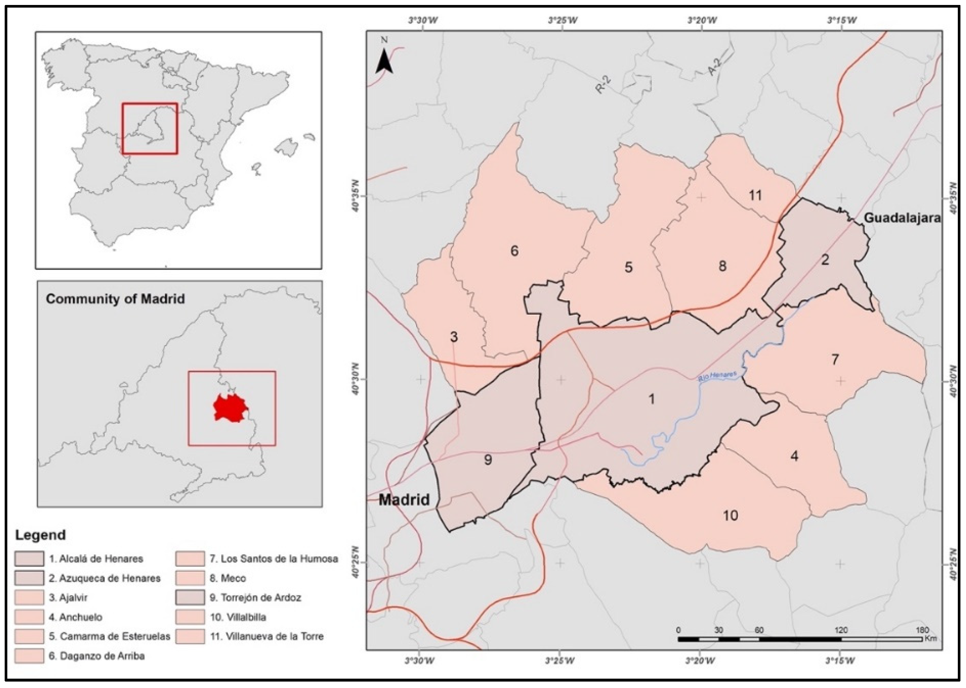
2. Study Area
3. Methods
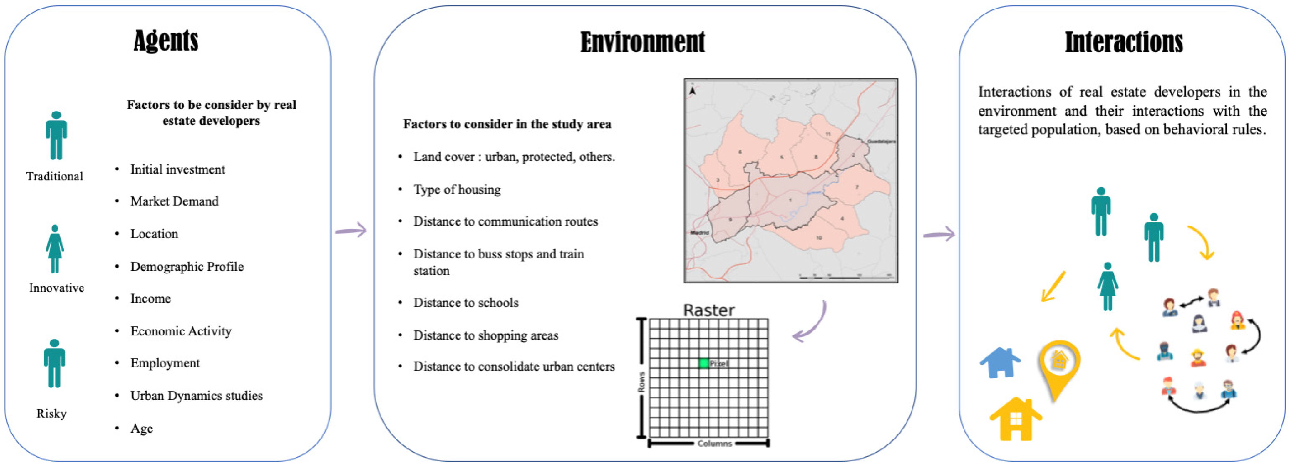
3.1. Identification of the Agents
3.2. Characterization of Real Estate Developers
3.2.1. Expert Knowledge
3.2.2. Questionnaire
4. Results
4.1. Real Estate as Agents
- Residential developments, which include both new construction and renovation/resale properties. The most common type of housing is single-family homes, although we can also find multi-family, mixed, vacation homes, etc.
- Commercial developments include shopping centers, medical buildings, hotels, offices, etc. In addition, private apartment buildings are often considered commercial, although in some cases they fall into the mixed category.
- Industrial developments include buildings for storage, production, and distribution of goods. Some of the distribution buildings can be considered as commercial. These types of developments are classified differently by their spatial location.
- Developments of undeveloped areas, including undeveloped areas and vacant land. These developments in some cases are combined with other adjacent properties in order to increase their density and the value of the property.
4.2. Analysis of the Stakeholder’s Participation
5. Conclusions
Author Contributions
Funding
Institutional Review Board Statement
Informed Consent Statement
Data Availability Statement
Conflicts of Interest
References
- Magliocca, N.R.; Rudel, T.K.; Verburg, P.H.; McConnell, W.J.; Mertz, O.; Gerstner, K.; Heinimann, A.; Ellis, E.C. Synthesis in land change science: Methodological patterns, challenges, and guidelines. Reg. Environ. Chang. 2015, 15, 211–226. [Google Scholar] [CrossRef] [PubMed]
- Turner, B.L.; Lambin, E.F.; Reenberg, A. The emergence of land change science for global environmental change and sustainability. Proc. Natl. Acad. Sci. USA 2007, 104, 20666–20671. [Google Scholar] [CrossRef] [PubMed]
- Plata, W.; Corrales, G.; Hinojoza, G.G.; Monjardin, S.A.; Beltrán, J.C.; Rodríguez, H.E. Spatial-Temporal Analysis of Territorial Transformations in the State of Sinaloa Mexico Using Geographic Information Systems. Agric. Sci. 2017, 8, 171–182. [Google Scholar] [CrossRef][Green Version]
- Andersson, C.; Lindgren, K.; Rasmussen, S.; White, R. Urban growth simulation from “first principles”. Phys. Rev. E 2002, 66, 026204. [Google Scholar] [CrossRef] [PubMed]
- Patra, S.; Sahoo, S.; Mishra, P.; Mahapatra, S.C. Impacts of urbanization on land use /cover changes and its probable implications on local climate and groundwater level. J. Urban Manag. 2018, 7, 70–84. [Google Scholar] [CrossRef]
- United Nations Human Settlements Programme. The Value of Sustainable Urbanization (World Cities Report 2020); United Nations Human Settlements Programme: Nairobi, Kenya, 2020. [CrossRef]
- Hersperger, A.M.; Oliveira, E.; Pagliarin, S.; Palka, G.; Verburg, P.; Bolliger, J.; Grădinaru, S. Urban land-use change: The role of strategic spatial planning. Glob. Environ. Chang. 2018, 51, 32–42. [Google Scholar] [CrossRef]
- Seto, K.C.; Guneralp, B.; Hutyra, L.R. Global forecasts of urban expansion to 2030 and direct impacts on biodiversity and carbon pools. Proc. Natl. Acad. Sci. USA 2012, 109, 16083–16088. [Google Scholar] [CrossRef]
- Rindfuss, R.R.; Walsh, S.J.; Turner, B.L.; Fox, J.; Mishra, V. Developing a science of land change: Challenges and methodological issues. Proc. Natl. Acad. Sci. USA 2004, 101, 13976–13981. [Google Scholar] [CrossRef]
- Rounsevell, M.D.; Pedroli, B.; Erb, K.-H.; Gramberger, M.; Busck, A.G.; Haberl, H.; Kristensen, S.; Kuemmerle, T.; Lavorel, S.; Lindner, M. Challenges for land system science. Land Use Policy 2012, 29, 899–910. [Google Scholar] [CrossRef]
- Bürgi, M.; Hersperger, A.M.; Schneeberger, N. Driving forces of landscape change-current and new directions. Landsc. Ecol. 2005, 19, 857–868. [Google Scholar] [CrossRef]
- Hersperger, A.M.; Bürgi, M. How do policies shape landscapes? Landscape change and its political driving forces in the Limmat Valley, Switzerland 1930–2000. Landsc. Res. 2010, 35, 259–279. [Google Scholar] [CrossRef]
- Brenner, N.; Schmid, C. Towards a new epistemology of the urban? City 2015, 19, 151–182. [Google Scholar] [CrossRef]
- Lee, H. An analysis on development capacity of an urbanized area for urban growth management. J. Korean Urban Geogr. Soc. 2008, 11, 1–18. [Google Scholar]
- Albrechts, L.; Balducci, A.; Hillier, J. Situated practices of strategic planning. An international perspective. Eur. Plan. Stud. 2017, 25, 351–354. [Google Scholar]
- Collier, M.J.; Nedović-Budić, Z.; Aerts, J.; Connop, S.; Foley, D.; Foley, K.; Newport, D.; McQuaid, S.; Slaev, A.; Verburg, P. Transitioning to resilience and sustainability in urban communities. Cities 2013, 32, S21–S28. [Google Scholar] [CrossRef]
- Ochunga, F.O.; Awiti, L.H. Influence of Stakeholder Participation on Sustainability of Community Development Projects Implemented by Plan International in Homa Bay Town Sub-County, Kenya. Int. J. Acad. Res. Bus. Soc. Sci. 2017, 7, 375–400. [Google Scholar] [CrossRef]
- Concha, F.J.M. Discrete Urban Economic Theory. In Microeconomic Modeling in Urban Science; Academic Press: Cambridge, MA, USA, 2018; pp. 41–71. [Google Scholar] [CrossRef]
- Fernández, S.; Collado, L. What has happened in Spain? The real estate bubble, corruption and housing development: A view from the local level. Geoforum 2017, 85, 206–213. [Google Scholar] [CrossRef]
- Haque, A.; Asami, Y. Optimizing urban land use allocation for planners and real estate developers. Comput. Environ. Urban Syst. 2014, 46, 57–69. [Google Scholar] [CrossRef]
- Pagliara, F.; Preston, J.; Simmonds, D. Residential location choice. In Advances in Spatial Science; Springer Science & Business Media: Berlin/Heidelberg, Germany, 2010. [Google Scholar]
- Alghais, N.; Pullar, D. Modelling future impacts of urban development in Kuwait with the use of ABM and GIS. Trans. GIS 2018, 22, 20–42. [Google Scholar] [CrossRef]
- Bousquet, F.; Le Page, C. Multi-agent simulations and ecosystem management: A review. Ecol. Model. 2004, 176, 313–332. [Google Scholar] [CrossRef]
- Brown, D.; Page, S.; Riolo, R.; Rand, W. Agent-based and analytical modeling to evaluate the effectiveness of greenbelts. Environ. Model. Softw. 2004, 19, 1097–1109. [Google Scholar] [CrossRef]
- Cantergiani, C.; Gómez Delgado, M. Simulación del crecimiento urbano con AMEBA: Modelo Basado en Agentes para la ocupación residencial. Bol. Asoc. Geógr. Esp. 2020, 86. [Google Scholar] [CrossRef]
- Gilbert, N.; Bankes, S. Platforms and methods for agent-based modeling. Proc. Natl. Acad. Sci. USA 2002, 99 (Suppl. 3), 7197–7198. [Google Scholar] [CrossRef] [PubMed]
- Jager, W.; Janssen, M.A.; De Vries, H.; De Greef, J.; Vlek, C. Behaviour in commons dilemmas: Homo economicus and Homo psychologicus in an ecological-economic model. Ecol. Econ. 2000, 35, 357–379. [Google Scholar] [CrossRef]
- Lee, J.-S.; Filatova, T.; Ligmann-Zielinska, A.; Hassani-Mahmooei, B.; Stonedahl, F.; Lorscheid, I.; Voinov, A.; Polhill, G.; Sun, Z.; Parker, D.C. The Complexities of Agent-Based Modeling Output Analysis. J. Artif. Soc. Soc. Simul. 2015, 18, 1460–7425. [Google Scholar] [CrossRef]
- Malik, A.; Abdalla, R. Agent-based modelling for urban sprawl in the region of Waterloo, Ontario, Canada. Modeling Earth Syst. Environ. 2017, 3, 7. [Google Scholar] [CrossRef]
- Matthews, R. The People and Landscape Model (PALM): Towards full integration of human decision-making and biophysical simulation models. Ecol. Model. 2006, 194, 329–343. [Google Scholar] [CrossRef]
- Parker, D.C.; Manson, S.M.; Janssen, M.A.; Hoffmann, M.J.; Deadman, P. Multi-agent systems for the simulation of land-use and land-cover change: A review. Ann. Assoc. Am. Geogr. 2003, 93, 314–337. [Google Scholar] [CrossRef]
- Phan, D. Agent-Based Modelling and Simulation in the Social and Human Sciences; Bardwell Press: Oxford, UK, 2007. [Google Scholar]
- Gilbert, N.; Hawksworth, J.C.; Swinney, P.A. An Agent-Based Model of the English Housing Market. In Proceedings of the AAAI Spring Symposium: Technosocial Predictive Analytics, Stanford, CA, USA, 23–25 March 2009; pp. 30–35. [Google Scholar]
- Filatova, T. Empirical agent-based land market: Integrating adaptive economic behavior in urban land-use models. Comput. Environ. Urban Syst. 2015, 54, 397–413. [Google Scholar] [CrossRef]
- Zhuge, C.; Shao, C.; Gao, J.; Dong, C.; Zhang, H. Agent-based joint model of residential location choice and real estate price for land use and transport model. Comput. Environ. Urban Syst. 2016, 57, 93–105. [Google Scholar] [CrossRef]
- Yun, T.-S.; Moon, I.-C. Housing market agent-based simulation with loan-to-value and debt-to-income. J. Artif. Soc. Soc. Simul. 2020, 23, 1–19. [Google Scholar] [CrossRef]
- Hewitt, R.; Escobar, F. The territorial dynamics of fast-growing regions: Unsustainable land use change and future policy challenges in Madrid, Spain. Appl. Geogr. 2011, 31, 650–667. [Google Scholar] [CrossRef]
- Barreira-González, P.; Aguilera-Benavente, F.; Gómez-Delgado, M. Implementation and calibration of a new irregular cellular automata-based model for local urban growth simulation: The MUGICA model. Environ. Plan. B Urban Anal. City Sci. 2017, 46, 243–263. [Google Scholar] [CrossRef]
- Cantergiani, C.; Gómez Delgado, M. Diseño de un modelo basado en agentes para simular el crecimiento urbano en el Corredor del Henares (Comunidad de Madrid). Bol. Asoc. Geógr. Esp. 2016, 70. [Google Scholar] [CrossRef]
- Del Rio Lafuente, I.; Moya, J.R. Áreas metropolitanas en transformación. Presente y futuro del Corredor del Henares en el área funcional madrileña/Metropolitan areas under transformation. Present and future of the “Corredor del Henares” in the functional area of Madrid. In Anales de Geografía de la Universidad Complutense; Universidad Complutense de Madrid: Madrid, Spain, 2009; p. 139. [Google Scholar]
- Martori, J.C.; Madariaga, R.; Oller, R. Real estate bubble and urban population density: Six Spanish metropolitan areas 2001–2011. Ann. Reg. Sci. 2016, 56, 369–392. [Google Scholar] [CrossRef]
- Instituto Nacional de Estadística. Cifras de Población (CP) a 1 de Enero de 2020 Estadística de Migraciones (EM). Año 2019-Datos Provisionales 2020, 981, 1–11. Available online: https://www.ine.es/en/index.htm (accessed on 30 May 2022).
- Cantergiani, C.; Gómez Delgado, M. Urban land allocation model of territorial expansion by urban planners and housing developers. Environments 2017, 5, 5. [Google Scholar] [CrossRef]
- Macal, C.M.; North, M.J. Tutorial on agent-based modelling and simulation. J. Simul. 2010, 4, 151–162. [Google Scholar] [CrossRef]
- Bonabeau, E. Predicting the unpredictable. Harv. Bus. Rev. 2002, 80, 109–116. [Google Scholar]
- Smajgl, A.; Brown, D.G.; Valbuena, D.; Huigen, M.G.A. Empirical characterisation of agent behaviours in socio-ecological systems. Environ. Model. Softw. 2011, 26, 837–844. [Google Scholar] [CrossRef]
- Cooke, R.M.; Goossens, L.L. TU Delft expert judgment data base. Reliab. Eng. Syst. Saf. 2008, 93, 657–674. [Google Scholar] [CrossRef]
- Nichols, P. Social survey methods: A fieldguide for development workers. In Social Survey Methods; Oxfam: Oxford, UK, 1991; Volume 6. [Google Scholar]
- Gendall, P. A framework for questionnaire design: Labaw revisited. Mark. Bull.-Dep. Mark. Massey Univ. 1998, 9, 28–39. [Google Scholar]
- Baker, M.J. Data collection–questionnaire design. Mark. Rev. 2003, 3, 343–370. [Google Scholar] [CrossRef]
- Molinero-Parejo, R.; Aguilera-Benavente, F.; Gómez-Delgado, M.; Soria-Lara, J.A. Mapping disruptive long-term scenarios using a participatory approach. J. Maps 2021, 17, 106–115. [Google Scholar] [CrossRef]
- Ley 38/1999, de 5 de Noviembre, de Ordenación de la Edificación. Modificación 15 de Julio de 2015. BOE No 266 Boletín Oficial del Estado (BOE) 1. 1999. Available online: https://www.boe.es/buscar/act.php?id=BOE-A-1999-21567 (accessed on 26 January 2021).
- Amadeo, K. What Is Real Estate? Real Estate Explained. Available online: https://www.thebalance.com/real-estate-what-it-is-and-how-it-works-3305882 (accessed on 7 June 2022).


| Population | ||
|---|---|---|
| Municipality | 2011 | 2021 |
| Alcalá de Henares | 203.686 | 195.982 |
| Azuqueca de Henares | 35.236 | 34.195 |
| Ajalvir | 4111 | 4676 |
| Anchuelo | 1135 | 1359 |
| Camarma de Esteruelas | 6682 | 7555 |
| Daganzo de Arriba | 9268 | 10,520 |
| Los Santos de la Humosa | 2297 | 2729 |
| Meco | 12,554 | 14,903 |
| Torrejón de Ardoz | 122.589 | 132.771 |
| Villalvilla | 10.465 | 15.049 |
| Villanueva de la Torre | 6284 | 6591 |
| Total | 413.266 | 427.371 |
| General Factors | Description |
| Interest rates | Investment rates affect the cost of mortgages |
| Taxes | Interest rates may vary by country. Each one establishes different interest rates that end up affecting the cost of the loans. That is, a low interest rate will allow more people to acquire a property, since the cost of the mortgage is lower |
| Investments | The value of properties tends to increase over time, which makes them an investment opportunity, leading to an increase in demand. |
| Local Factors | |
| New construction | Increases the supply of the real estate market by providing new properties for sale/purchase |
| Transportation | Having easy access to public transportation increases the demand for a real estate development |
| Land use limitations | One factor to take into account is the use that can be made of the land, since it may be limited according to the urban classification assigned to it |
| Job availability | Access to jobs directly affects local real estate demand |
| Age | In most cases, the age of the population plays an important role. For example, on many occasions, the retired population chooses to downsize and move to quieter developments |
Publisher’s Note: MDPI stays neutral with regard to jurisdictional claims in published maps and institutional affiliations. |
© 2022 by the authors. Licensee MDPI, Basel, Switzerland. This article is an open access article distributed under the terms and conditions of the Creative Commons Attribution (CC BY) license (https://creativecommons.org/licenses/by/4.0/).
Share and Cite
Hinojoza-Castro, G.; Gómez-Delgado, M.; Plata-Rocha, W. Real Estate Developers as Agents in the Simulation of Urban Sprawl. Sustainability 2022, 14, 8994. https://doi.org/10.3390/su14158994
Hinojoza-Castro G, Gómez-Delgado M, Plata-Rocha W. Real Estate Developers as Agents in the Simulation of Urban Sprawl. Sustainability. 2022; 14(15):8994. https://doi.org/10.3390/su14158994
Chicago/Turabian StyleHinojoza-Castro, Geovanna, Montserrat Gómez-Delgado, and Wenseslao Plata-Rocha. 2022. "Real Estate Developers as Agents in the Simulation of Urban Sprawl" Sustainability 14, no. 15: 8994. https://doi.org/10.3390/su14158994
APA StyleHinojoza-Castro, G., Gómez-Delgado, M., & Plata-Rocha, W. (2022). Real Estate Developers as Agents in the Simulation of Urban Sprawl. Sustainability, 14(15), 8994. https://doi.org/10.3390/su14158994