
Influence of Environmental Factors on Urban and Architectural Design—Example of a Former Paper Mill in Nanterre


Abstract
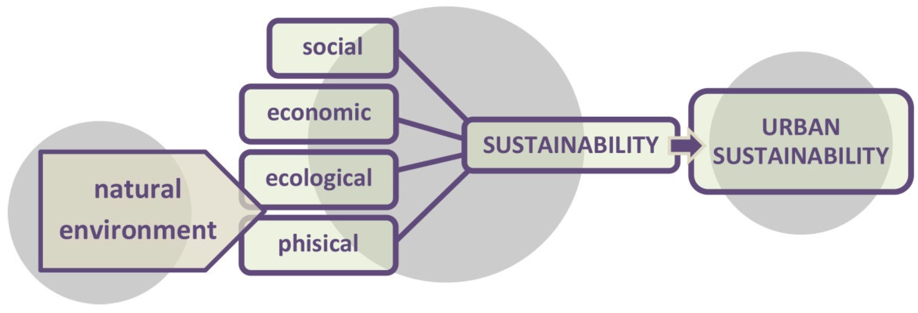
:1. Introduction
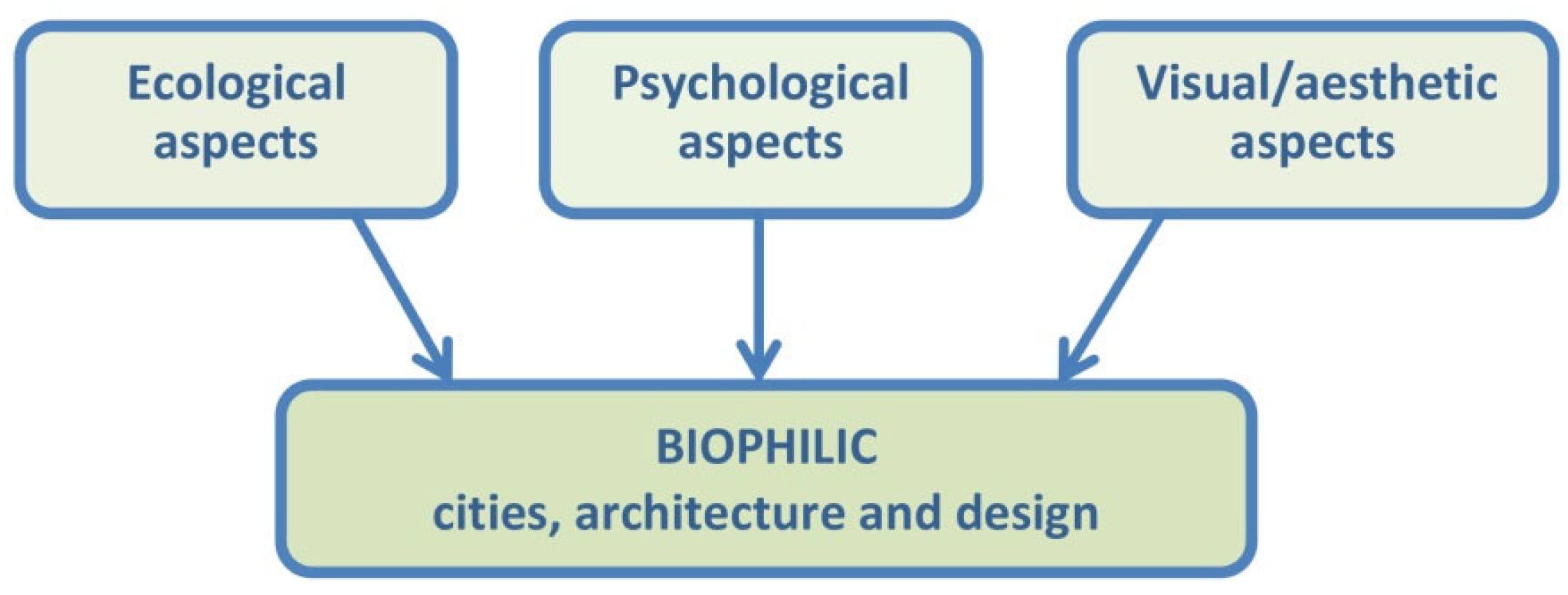
- The requirement of repeated and sustained engagements with nature;
- The concentration on human adaptations to the natural world that, over evolutionary time, have advanced people’s health, fitness and wellbeing;
- The encouragement of an emotional attachment to particular settings and places;
- The promotion of positive interactions between people and nature that encourage an expanded sense of relationship and responsibility for the human and natural communities;
- The encouragement of mutually reinforcing, interconnected, and integrated architecture.
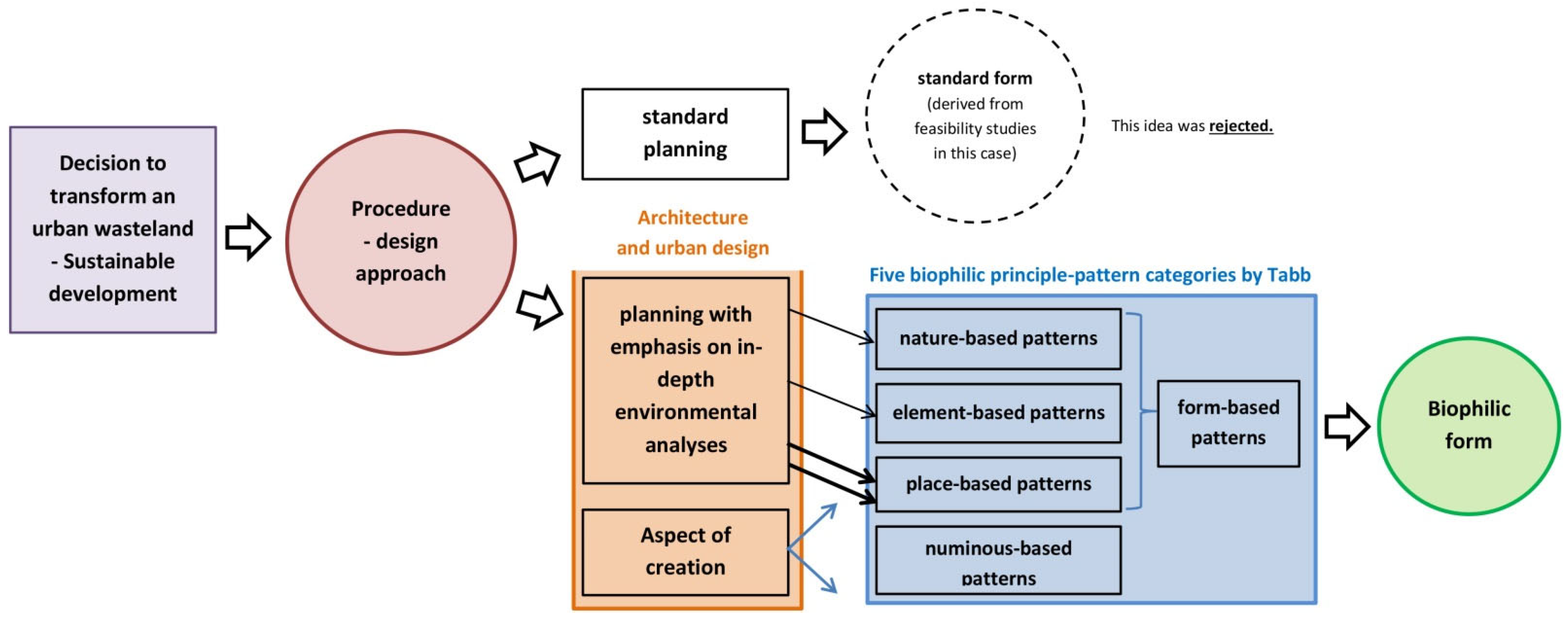
2. Methodology
- formal and legal (legislative) documents;
- sources directly related to the place: archives, planning materials, expert (opinions, reports, and expert opinions), iconography;
- design materials;
- public information (including the local law);
- elements of journalism (as part of the discourse);
- scientific source literature related to the described issues—broadly understood sustainable city development.
- A. Ideological concepts in city planning and formal conditions resulting from regional and local development plans;
- B. Urban conditions resulting from the built environment;
- C. The importance of history and heritage;
- D. The influence of the physical environment on the formation of the concept for the development complex;
- E. Landscape protection and shaping; the influence of the natural environment on decisions;
- F. The influence of social and economic conditions;
- G. Actions against anthropopressure and factors that lead to urban environmental degradation.
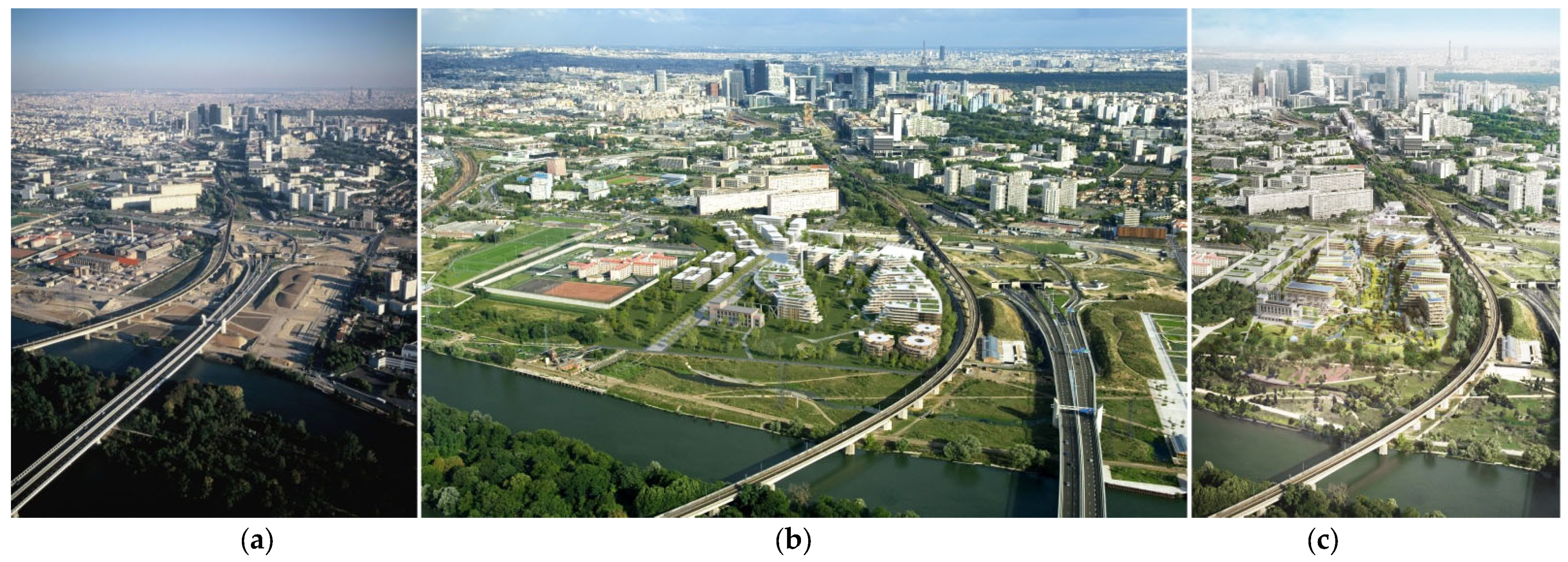
Process of Urban Transformation
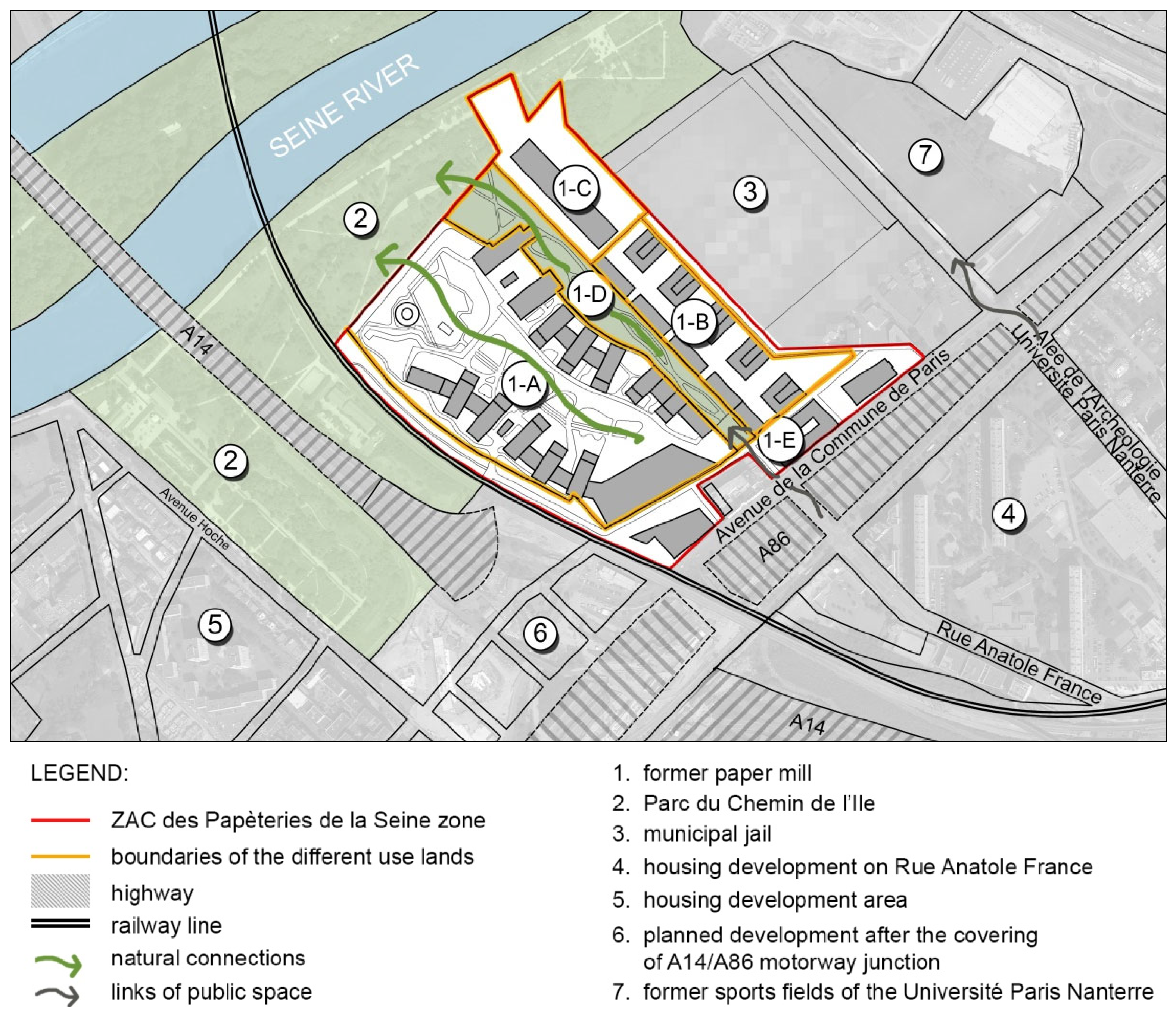
3. A Case Study of the Urban Development Zone—Zone d’Aménagement Concerté des Papèteries de la Seine (ZAC des Papèteries de la Seine)
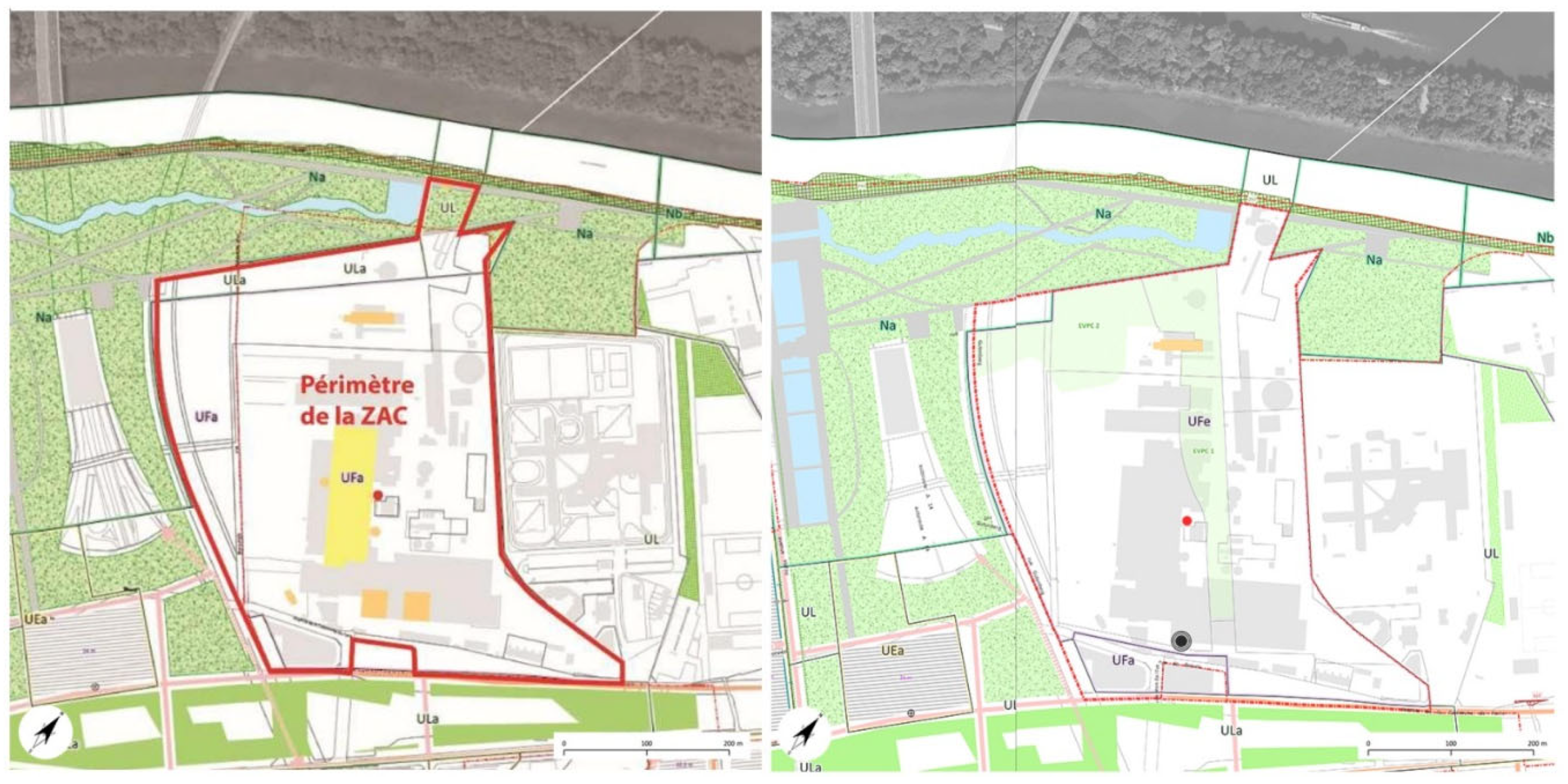
3.1. Formal Conditions Resulting from Urban Plans (A)
3.1.1. Arrangements Resulting from the Plans: Regional and Local Arrangements for the Former Paper Mill Area
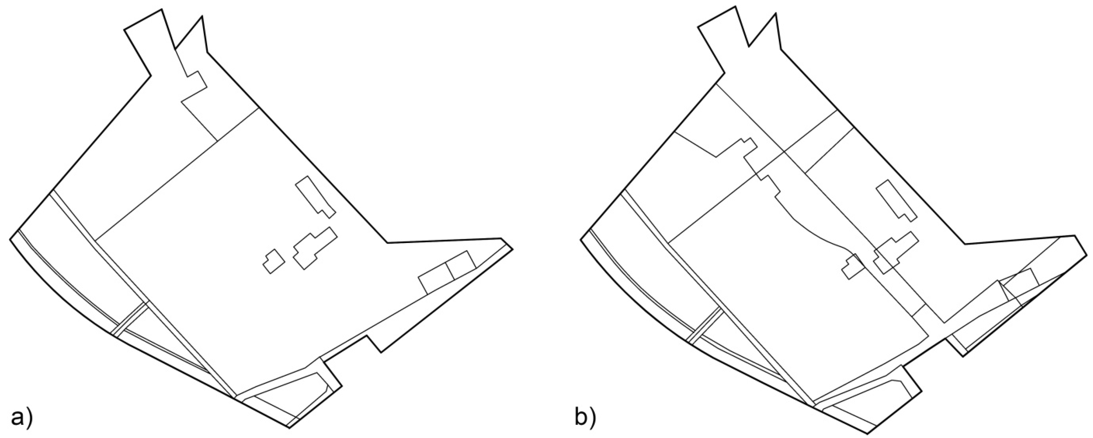
3.1.2. Land Subdivision
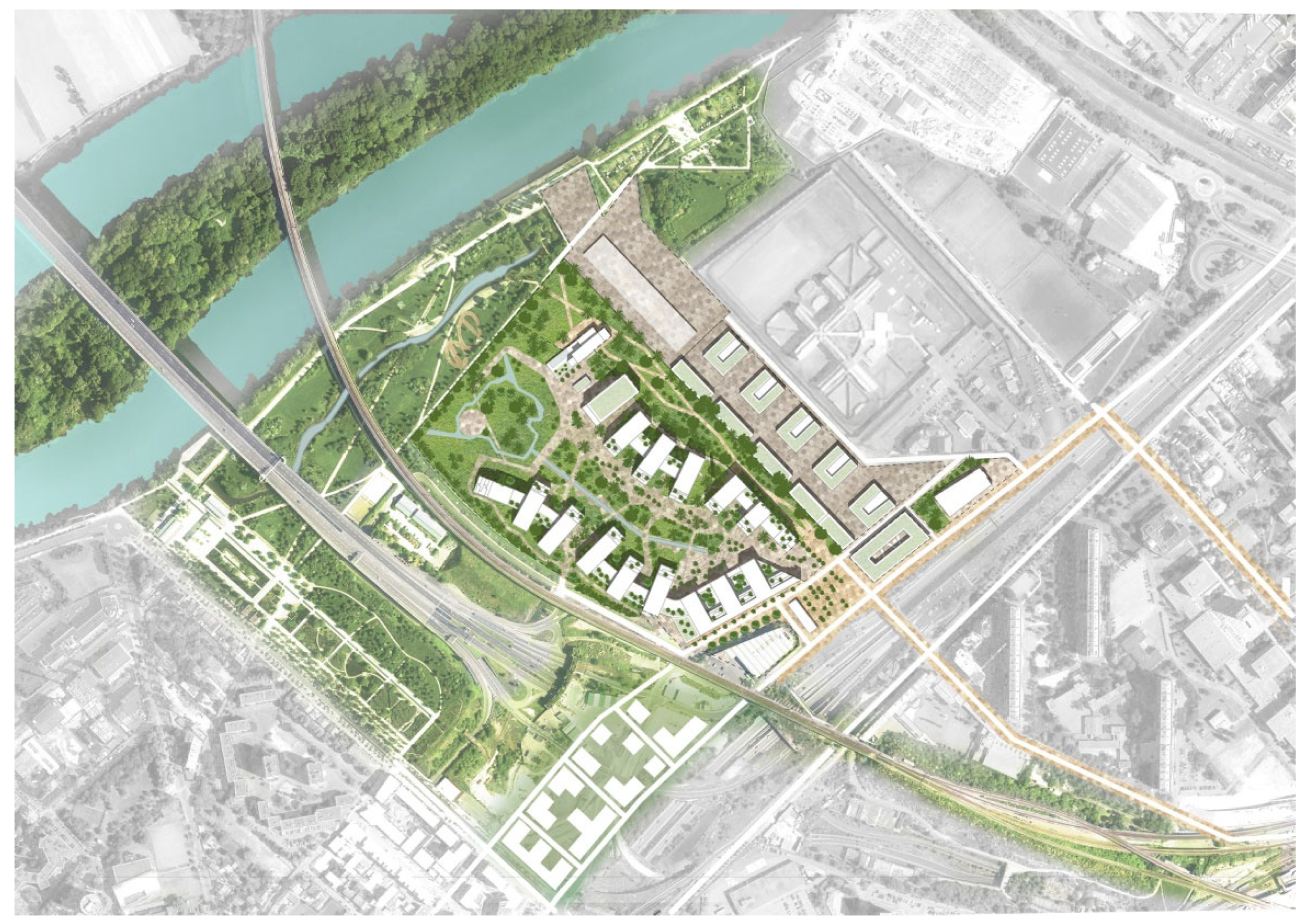
3.1.3. Functional-Spatial Program
3.2. Urban and Built Environment Conditions (B)
3.2.1. Location of the Area within the City Structure
3.2.2. Urban Layout Characteristics
3.3. The Importance of History and Heritage (C)
3.3.1. Valorization of Facilities on the Former Paper Mill Premises
3.3.2. Assessment of the Preservation of Past Elements in the Project
3.4. The Influence of the Physical Environment on the Formation of the Building Development Complex Concept (D)
3.4.1. Climate
3.4.2. Topographic and Geological Conditions
3.4.3. Subcutaneous and Surface Waters
3.4.4. Flood Threat
3.4.5. Solutions Related to Rainwater Collection
3.5. Landscape Protection and Shaping; the Impact of the Natural Environment on Design Decisions (E)
3.5.1. Landscape and Influence on Design Solutions
3.5.2. Plant and Animal Habitats
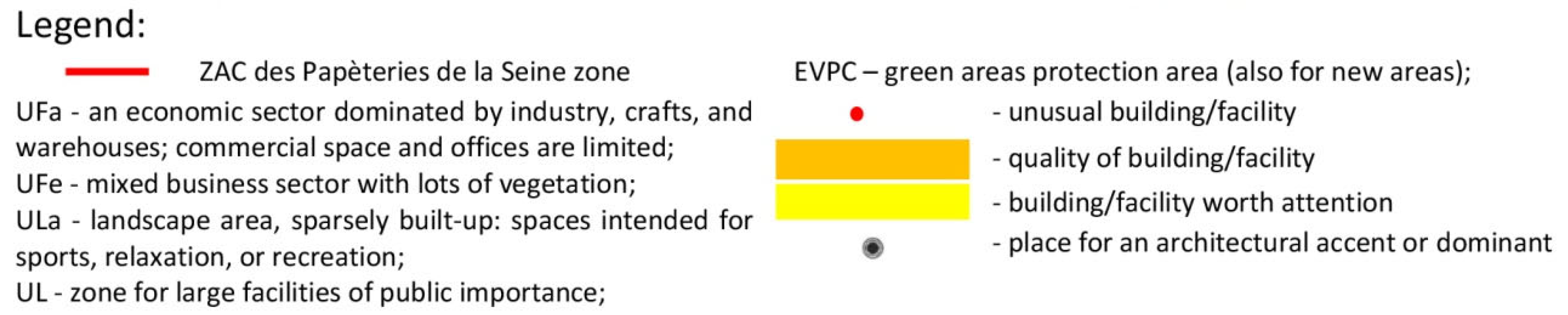
3.5.3. Special Protection for Greenery Areas (EVP1 and EVP2)
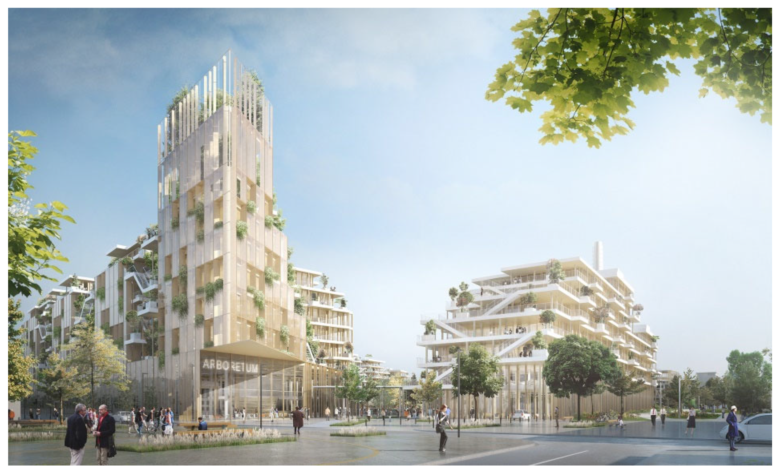
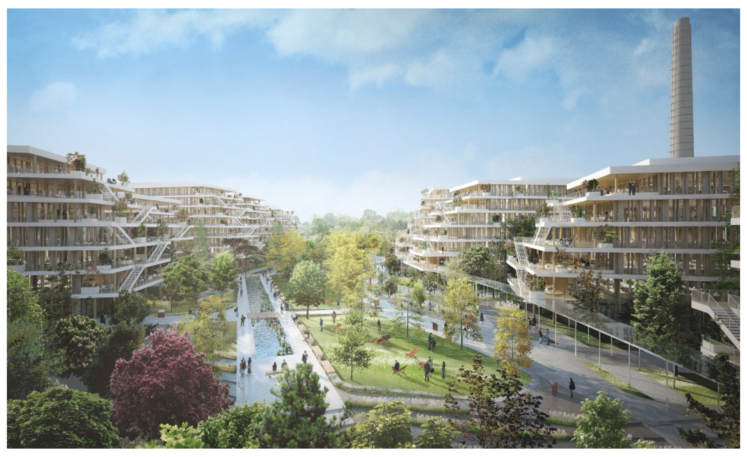
3.5.4. Landscape Solutions in the Project—Composition
3.6. Influence of Social and Economic Conditions (F)
3.6.1. Improving Public Health as the Project’s Guideline
3.6.2. Area Function, Workplace, Program Variety
3.6.3. Communication System
3.6.4. Social Importance of Public Space
3.7. Actions against Anthropopressure and Factors That Degrade the Urban Environment (G)
3.7.1. Air Quality
3.7.2. Noise
3.7.3. Industrial Contamination
3.7.4. Construction Waste Management
4. Results
- change within the communication system, forced by environmental factors;
- creating landscape connections (also: ecological and visual)—opening to the Seine valley, connecting with other elements of the city’s natural system—e.g., Parc du Chemin de l’Ile;
- the protection of grasslands, introducing elements of surface water and wetlands into the landscape—the protection of biodiversity; creating refuges for flora and fauna;
- the use of the landscape nature of the campus for the development of educational and social practices outdoors;
- the use of wood in the construction of academic facilities;
- the use of surface water and greenery to create a microclimate of the place—leveling the effects of urban heat islands;
- the minimization of sealed and built-up areas for the drainage of rainwater within the plot;
- creating a buffer zone with greenery facing the railway;
- shaping the topography with the use of earth masses from a given area.
- -
- making the natural system more readable in urban structure;
- -
- highlighting the landscape values of a river valley;
- -
- seeking landscape continuity;
- -
- the protection of flora and fauna habitats (possible compensation of development elsewhere in the plot);
- -
- the creation of wetland habitats;
- -
- the use of water to create microclimate of the site;
- -
- a high degree of greening (use of various forms of greenery, green infrastructure);
- -
- the creation of enclaves excluded from active use;
- -
- shaping the topography with the use of earth masses from the site;
- -
- the use of natural materials as building material—e.g., wood;
- -
- the creation of soft forms, referring to natural forms.
5. Discussion
6. Conclusions
- -
- Nature-based solutions (NBS) do not always lead to biophilic forms. This depends on the accumulation of biophilicity criteria. The multifaceted nature of environmental conditions is the source of the emergence of a biophilic form in the form of layout and built form;
- -
- Systemic planning solutions strongly support the development of biophilicity, and do not determine the form of areas completely but may have a dimension at the scale of the entire city (e.g., by strengthening ecosystem connections or a greater share of greenery in the development of individual areas). The choice of a formal approach with an in-depth environmental analysis is a key aspect that provides the opportunity and suggestion to implement this type of project;
- -
- Usually, the identification of biophilicity is made based on criteria: Beatley, Kellert, Browning, etc. Spatial, perceptual aspects resulting from the research experience of environmental psychology can be added to these indications;
- -
- The formal process has an impact on the design approach.
Author Contributions
Funding
Institutional Review Board Statement
Informed Consent Statement
Data Availability Statement
Acknowledgments
Conflicts of Interest
References
- Global Platform for Sustainable Cities. Urban Sustainability Framework; World Bank: Washington, DC, USA, 2018; Available online: http://documents1.worldbank.org/curated/en/339851517836894370/pdf/123149-Urban-Sustainability-Framework.pdf (accessed on 3 May 2021).
- United Nations. World Urbanization Prospects: The 2014 Revision; United Nations, Department of Economic and Social Affairs, Population Division: New York, NY, USA, 2015; Available online: https://esa.un.org/unpd/wup/Publications/Files/WUP2014-Report.pdf (accessed on 3 May 2021).
- Hoornweg, D.; Sugar, L.; Gómez, C.L.T. Cities and greenhouse gas emissions: Moving forward. Environ. Urban. 2011, 23, 207–227. [Google Scholar] [CrossRef]
- Goodland, R. The concept of environmental sustainability. Annu. Rev. Ecol. Syst. 1995, 26, 1–24. [Google Scholar] [CrossRef]
- Haughton, G.; Hunter, C. Sustainable Cities; Routledge: London, UK, 2004. [Google Scholar]
- Andersson, E. Urban landscapes and sustainable cities. Ecol. Soc. 2006, 11, 36. [Google Scholar] [CrossRef]
- Bithas, K.P.; Christofakis, M. Environmentally sustainable cities. Critical review and operational conditions. Sustain. Dev. 2006, 14, 177–189. [Google Scholar] [CrossRef]
- Moldan, B.; Janoušková, S.; Hák, T. How to understand and measure environmental sustainability: Indicators and targets. Ecol. Indic. 2012, 17, 4–13. [Google Scholar] [CrossRef]
- Pickett, S.T.; Cadenasso, M.L.; McGrath, B. (Eds.) Resilience in Ecology and Urban Design: Linking Theory and Practice for Sustainable Cities; Springer Science & Business Media: Berlin/Heidelberg, Germany, 2013; Volume 3, p. 499. [Google Scholar]
- Martos, A.; Pacheco-Torres, R.; Ordóñez, J.; Jadraque-Gago, E. Towards successful environmental performance of sustainable cities: Intervening sectors. A review. Renew. Sustain. Energy Rev. 2016, 57, 479–495. [Google Scholar] [CrossRef]
- Bibri, S.E.; Krogstie, J. Smart sustainable cities of the future: An extensive interdisciplinary literature review. Sustain. Cities Soc. 2017, 31, 183–212. [Google Scholar] [CrossRef]
- United Nations. Rio declaration on environment and development. In Proceedings of the United Nations Conference on Environment and Development, Rio de Janerio, Brazil, 3–14 June 1992; Available online: https://www.un.org/en/development/desa/population/migration/generalassembly/docs/globalcompact/A_CONF.151_26_Vol.I_Declaration.pdf (accessed on 25 April 2021).
- European Cities & Towns Towards Sustainability. The Aalborg Charter. Available online: https://sustainablecities.eu/fileadmin/repository/Aalborg_Charter/Aalborg_Charter_English.pdf (accessed on 3 May 2021).
- European Council of Town Planners. The New Charter of Athens; Alinea: Florence, Italy, 2003. [Google Scholar]
- European Commision. LEIPZIG CHARTER on Sustainable European Cities; Official Journal of the European Union, 2009. Available online: https://ec.europa.eu/regional_policy/sources/activity/urban/leipzig_charter.pdf (accessed on 25 April 2021).
- European Commision. THE NEW LEIPZIG CHARTER The Transformative Power of Cities for the Common Good; Official Journal of the European Union, 2020. Available online: https://ec.europa.eu/regional_policy/en/information/publications/brochures/2020/new-leipzig-charter-the-transformative-power-of-cities-for-the-common-good (accessed on 25 April 2021).
- United Nations. United Nations Conference on Sustainable Development “The Future We Want” (UNCSD); United Nations: New York, NY, USA, 2012. Available online: https://sustainabledevelopment.un.org/content/documents/733FutureWeWant.pdf (accessed on 25 April 2021).
- United Nations. Transforming Our World: The 2030 Agenda for Sustainable Development; United Nations: New York, NY, USA, 2015. Available online: https://www.un.org/ga/search/view_doc.asp?symbol=A/RES/70/1&Lang=E (accessed on 25 April 2021).
- United Nations. Paris agreement. In Proceedings of the United Nations Framework Convention on Climate Change, 21st Conference of the Parties, COP21, Paris, France, 20 November–12 December 2015; Available online: https://www.undp.org/content/undp/en/home/presscenter/events/2015/december/COP21-paris-climate-conference.html (accessed on 25 April 2021).
- United Nations. United Nations Decade on Biodiversity 2011–2020. Available online: https://undocs.org/A/RES/65/161 (accessed on 25 April 2021).
- United Nations. HABITAT III. New Urban Agenda. Available online: https://europa.eu/capacity4dev/file/31483/download?token=b_Z4h8W4 (accessed on 25 November 2021).
- United Nations. International Decade for Action, “Water for Sustainable Development” 2018–2028. Available online: https://undocs.org/en/A/RES/71/222 (accessed on 25 April 2021).
- United Nations. United Nations Decade on Ecosystem Restoration 2021–2030. Available online: https://undocs.org/A/RES/73/284 (accessed on 25 April 2021).
- Hanna, E.; Comín, F.A. Urban Green Infrastructure and Sustainable Development: A Review. Sustainability 2021, 13, 11498. [Google Scholar] [CrossRef]
- Mathey, J.; Rink, D. Greening brownfields in urban redevelopment. In Sustainable Built Environments; Encyclopedia of Sustainability Science and Technology Series; Loftness, V., Ed.; Springer: New York, NY, USA, 2020. [Google Scholar]
- Hammond, E.B.; Coulon, F.; Hallett, S.H.; Thomas, R.; Hardy, D.; Kingdon, A.; Beriro, D.J. A critical review of decision support systems for brownfield redevelopment. Sci. Total Environ. 2021, 785, 147132. [Google Scholar] [CrossRef]
- Mestre, N.; Roig, E.; Almestar, M. Beyond Nature-Based Rhetorics: A Prospect on the Potentials of Redundancy in Ecology-Oriented Design. Sustainability 2021, 13, 13293. [Google Scholar] [CrossRef]
- Totaforti, S. Emerging Biophilic Urbanism: The Value of the Human–Nature Relationship in the Urban Space. Sustainability 2020, 12, 5487. [Google Scholar] [CrossRef]
- Brand, J.L.; Augustin, S. Can We Sustain Sustainability? A Critical Synthesis of Pertinent Literature. Sustainability 2021, 13, 12753. [Google Scholar] [CrossRef]
- Wilson, E.O. Biophilia; Harvard University Press: Cambridge, MA, USA, 1984. [Google Scholar]
- Böhme, G. The Aesthetics of Atmospheres; Routledge: London, UK, 2016. [Google Scholar]
- Qingjiu, S.; Maliki, N.Z. Place attachment and place identity: Undergraduate students’ place bonding on campus. Procedia Soc. Behav. Sci. 2013, 91, 632–639. [Google Scholar] [CrossRef] [Green Version]
- Kaplan, S. The restorative benefits of nature: Toward an integrative framework. J. Environ. Psychol. 1995, 15, 169–182. [Google Scholar] [CrossRef]
- Kaplan, R.; Kaplan, S. The Experience of Nature: A Psychological Perspective; Cambridge University Press: Cambridge, UK, 1989. [Google Scholar]
- Ulrich, R.S. Aesthetic and affective response to natural environment. In Behavior and the Natural Environment; Altman, I., Wohlwill, J.F., Eds.; Springer: Boston, MA, USA, 1983; Volume 6, pp. 85–125. [Google Scholar]
- Appleton, J. The Experience of Landscape; John Wiley & Sons: Hoboken, NJ, USA, 1975. [Google Scholar]
- Peters, T.; D’Penna, K. Biophilic Design for Restorative University Learning Environments: A Critical Review of Literature and Design Recommendations. Sustainability 2020, 12, 7064. [Google Scholar] [CrossRef]
- Beatley, T. Biophilic Cities: Integrating Nature into Urban Design and Planning; Island Press: Washington, DC, USA, 2011. [Google Scholar]
- Beatley, T.; Neman, P. Biophilic Cities Are Sustainable, Resilient Cities. Sustainability 2013, 5, 3328–3345. [Google Scholar] [CrossRef] [Green Version]
- Kellert, S.R.; Heerwagen, J.; Mador, M. (Eds.) Biophilic Design: The Theory, Science and Practice of Bringing Buildings to Life; John Wiley & Sons: Hoboken, NJ, USA, 2011. [Google Scholar]
- Kellert, S.R. Dimensions, Elements, and Attributes of Biophilic Design. In Biophilic Design: The Theory, Science, and Practice of Bringing Buildings to Life; Kellert, S.R., Heerwagen, J., Mador, M., Eds.; John Wiley & Sons: Hoboken, NJ, USA, 2018. [Google Scholar]
- Browning, W.; Ryan, C.; Clancy, J. 14 Patterns of Biophilic Design; Terrapin Bright Green, LLC: New York, NY, USA, 2014; Available online: https://www.terrapinbrightgreen.com/reports/14-patterns/ (accessed on 5 April 2021).
- Kellert, S.; Calabrese, E. The Practice of Biophilic Design; Terrapin Bright LLC: New York, NY, USA, 2015. [Google Scholar]
- Røe, P.G.; Mark Luccarelli, M. Biophilic Oslo, Green Oslo Visions, Planning, and Discourse; Routledge: London, UK, 2013. [Google Scholar]
- Tabb, P.J. Biophilic Urbanism: Designing Resilient Communities for the Future; Routledge: London, UK, 2020. [Google Scholar]
- Andreucci, M.B.; Loder, A.; Brown, M.; Brajković, J. Exploring Challenges and Opportunities of Biophilic Urban Design: Evidence from Research and Experimentation. Sustainability 2021, 13, 4323. [Google Scholar] [CrossRef]
- Amat, R.C.; Ismail, S.; Wahab, M.H.; Ahmad, N.H.; Rani, W.N.M.W.M. A Dimension of Biophilia in Urban Design. IOP Conf. Ser. Earth Environ. Sci. 2020, 409, 12–16. [Google Scholar] [CrossRef]
- Lee, E.J.; Park, S.J. Toward the Biophilic Residential Regeneration for the Green New Deal. Int. J. Environ. Res. Public Health 2021, 18, 2523. [Google Scholar] [CrossRef]
- Lee, S.; Kim, Y. A framework of biophilic urbanism for improving climate change adaptability in urban environments. Urban For. Urban Green. 2021, 61, 127104. [Google Scholar] [CrossRef]
- Ghaziani, R.; Lemon, M.; Atmodiwirjo, P. Biophilic Design Patterns for Primary Schools. Sustainability 2021, 13, 12207. [Google Scholar] [CrossRef]
- Abdelaal, M.S. Biophilic campus: An emerging planning approach for a sustainable innovation-conducive university. J. Clean Prod. 2019, 215, 1445–1456. [Google Scholar] [CrossRef]
- König, A. Regenerative Sustainable Development of Universities and Cities; Edward Elgar: Cheltenham, UK, 2013; p. 352. [Google Scholar]
- International Sustainable Campus Network. Sustainable Development: Education with Purpose; 2018 Sustainable Campus Case Studies. Available online: https://international-sustainable-campus-network.org/download/521/ (accessed on 22 April 2021).
- Ashworth, G.J.; Larkham, P.J. A heritage for Europe. The need, the task, the contribution. In Building a New Heritage. Tourism, Culture and Identity in the New Europe; Ashworth, G.J., Larkham, P.J., Eds.; Routledge: London, UK, 1994. [Google Scholar]
- Tellis, W. Application of a case study methodology. Qual. Rep. 1997, 3, 1–19. [Google Scholar]
- Yin, R. Case Study Research: Design and Methods, 4th ed.; Sage: Thousand Oaks, CA, USA, 2009. [Google Scholar]
- Hafiz, K. Case study example. Qual. Rep. 2008, 13, 544–559. [Google Scholar]
- Groat, L. Case studies and combined strategies. In Architectural Research Methods; Groat, L., Wang, D., Eds.; John Wiley & Sons: Hoboken, NJ, USA, 2013; pp. 415–453. [Google Scholar]
- Cornaille, J. La papeterie de la Seine 1904–2004. In Bulletin n 38–juin 2007; Sociéte d’Historie de Nanterre: Nanterre, France.
- Girling, C.; Ronald, K. Skinny Streets and Green Neighborhoods: Design for Environment and Community; Island Press: Washington, DC, USA, 2005. [Google Scholar]
- Le Prefet des Hauts-de-Seine. Arrete Prefectoral No 2018-184 en Date du 23 Novembre 2018 Autorisant l’Amenagement de la ZAC des Papeteries sur la Commune de Nanterre (92). Available online: https://www.hauts-de-seine.gouv.fr/index.php/content/download/12499/87602/file/AP+d%27autorisation+environnementale+du+23+novembre+2018+-ZAC+des+papeteries_Nanterre.pdf (accessed on 1 December 2020).
- Le Prefet des Hauts-de-Seine. Arrêté Prefectoral DCPPAT No 2020-23 en Date du 21 Fevrier 2020 Complementaire de l’Arrete no 2018-184 en Date du 28 Novembre 2018 Portant Autorisation de l’Amenagement de la ZAC des Papeteries a Nanterre. Available online: https://www.hauts-de-seine.gouv.fr/index.php/content/download/14924/99998/file/2020+20+02+APC+ZAC+des+Papeteries.pdf (accessed on 1 December 2020).
- Le Schéma Directeur de la Région Île-de-France (SDRiF). Décret No 2013-1241 du 27 Décembre 2013 Portant Approbation du Schéma Directeur de la Région d’Ile-de-France. Available online: https://www.legifrance.gouv.fr/loda/id/JORFTEXT000028396726/ (accessed on 1 December 2020).
- Plan Local d’Urbanisme de la Commune de Nanterre 2015 (PLU de Nanterre). PLU Approuvé par le Conseil Municipal du 15 Décembre 2015; Départment des Hauts-de-Seine/Ville Naterre: Nanterre, France, 2015. [Google Scholar]
- Plan Local d’Urbanisme de la Commune de Nanterre 2015 (PLU de Nanterre). PLU Approuvé par le Conseil Municipal du 15 Décembre 2015 et Mis à Jour par Arrêté en Date du 6 Avril 2021 (The Revision of the Plan from 2021). Départment des Hauts-de-Seine/Ville Naterre, Nanterre, France 2021. Available online: https://www.nanterre.fr/746-plan-local-d-urbanisme.htm (accessed on 15 April 2021).
- Burtenshaw, D.; Bateman, M.; Ashworth, G.J. The European City: Western Perspectives; Routledge: London, UK, 1991. [Google Scholar]
- Alfrey, J.; Putnam, T. The Industrial Heritage: Managing Resources and Uses; Routledge: London, UK, 2003. [Google Scholar]
- Douet, J. (Ed.) Industrial Heritage Re-Tooled: The TICCIH Guide to Industrial Heritage Conservation; Left Coast Press: Walnut Creek, CA, USA, 2013. [Google Scholar]
- Wicke, C.; Berger, S.; Golombek, J. (Eds.) Industrial Heritage and Regional Identities; Routledge: London, UK, 2018. [Google Scholar]
- Monnet, A. Menaces pour “Les Papeteries de la Seine”. Écho Val Seine 2013, 67. Available online: http://valdeseinevert.org/menaces-pour-les-papeteries-de-la-seine/ (accessed on 7 April 2021).
- Société d’Économie Mixte d’Aménagement et de Gestion de la Ville de Nanterre (SEMNA) & SCE Aménagement & Environnement. Projet d’Amenagement de la ZAC des Papéteries—Commune de Nanterre (92)—Étude d’Impact; SEMNA: Nanterre, France, 2017. [Google Scholar]
- Archives Départementales des Hauts-de-Seine. Papeterie de la Sein; AD92_GHERRAM_20190826113040. Available online: https://francearchives.fr/findingaid/ef27551e3dced6dbf313279c9ac9bab0bf3cf0c2 (accessed on 7 April 2021).
- Masson, V.; Marchadier, C.; Adolphe, L.; Aguejdad, R.; Avner, P.; Bonhomme, M.; Bretagne, G.; Briottet, X.; Bueno, B.; de Munck, C.; et al. Adapting cities to climate change: A systemic modelling approach. Urban Clim. 2014, 10, 407–429. [Google Scholar] [CrossRef]
- Omer, A. Renewable building energy systems and passive human comfort solutions. Renew. Sustain. Energy Rev. 2008, 12, 1562–1587. [Google Scholar] [CrossRef]
- Foster, J.; Lowe, A.; Winkelman, S. The Value of Green Infrastructure for Urban Climate Adaptation; The Center for Clean Air Policy: Washington, DC, USA, 2011. [Google Scholar]
- Wilmers, F. Effects of vegetation on urban climate and buildings. Energy Build. 1990, 15, 507–514. [Google Scholar] [CrossRef]
- Wong, N.-H.; Chen, Y. The role of urban greenery in high-density cities. In Designing High-Density Cities for Social and Environmental Sustainability; Ng, E., Ed.; EarthScan: London, UK, 2010; pp. 227–262. [Google Scholar]
- Heidt, V.; Neef, M. Benefits of urban green space for improving urban climate. In Ecology, Planning, and Management of Urban Forests; Springer: New York, NY, USA, 2008; pp. 84–96. [Google Scholar]
- Grochulska-Salak, M. Re-urbanization in a model of sustainable development of an eco-city. Acta Sci. Pol. Archit. 2021, 20, 3–12. [Google Scholar] [CrossRef]
- Meggers, F.; Leibundgut, H.; Kennedy, S.; Qin, M.; Schlaich, M.; Sobek, W.; Shukuya, M. Reduce CO2 from buildings with technology to zero emissions. Sustain. Cities Soc. 2012, 2, 29–36. [Google Scholar] [CrossRef]
- Roodman, D.; Lenssen, N. Worldwatch Paper #124: A Building Revolution: How Ecology and Health Concerns are Transforming Construction; Worldwatch Institute: Washington, DC, USA, 1995.
- Guo, H.; Liu, Y.; Chang, W.S.; Shao, Y.; Sun, C. Energy saving and carbon reduction in the operation stage of cross laminated timber residential buildings in China. Sustainability 2017, 9, 292. [Google Scholar] [CrossRef] [Green Version]
- Chen, C.X.; Pierobon, F.; Ganguly, I. Life Cycle Assessment (LCA) of Cross-Laminated Timber (CLT) produced in Western Washington: The role of logistics and wood species mix. Sustainability 2019, 11, 1278. [Google Scholar] [CrossRef] [Green Version]
- Sabbah, C. Le bois à l’assaut d’un mégaprojet immobilier. Le Echos, 4 May 2017. Available online: https://www.lesechos.fr/2017/05/le-bois-a-lassaut-dun-megaprojet-immobilier-170920(accessed on 5 May 2021).
- Missions Régionales d’Autorité Environnementale (MRAe). Avis en Date du 28 Décembre 2017 de la Mission Régionale d’Autorité Environnementale d’Île-de-France sur le Projet d’Aménagement du Site des Papeteries Situé ŕ Nanterre (Hauts-de-Seine). Available online: http://www.mrae.developpement-durable.gouv.fr/IMG/pdf/171228_mrae_avis_amenagement_site_papeteries_nanterre_92.pdf (accessed on 13 April 2021).
- Mora, E.P. Life cycle, sustainability and the transcendent quality of building materials. Build. Environ. 2007, 42, 1329–1334. [Google Scholar] [CrossRef]
- Magnusson, S.; Lundberg, K.; Svedberg, B.; Knutsson, S. Sustainable management of excavated soil and rock in urban areas–a literature review. J. Clean Prod. 2015, 93, 18–25. [Google Scholar] [CrossRef] [Green Version]
- DRIEE Ile-de-France, Enveloppes d’Alerte des Zones Humides Avérées et Potentielles en Région Île-de-France. Available online: http://carto.geo-ide.application.developpement-durable.gouv.fr/73/Zones_humides.map (accessed on 13 April 2021).
- Plan de Prevention du Risque Inondation de la Seine dans le Département des Hauts-de-Seine (P.P.R.I.). Arrêté DRCT/1 no 2004-01 en Date du 9 Janvier 2004 Portant Approbation du Plan de Prevention du Risque Inondation de la Seine dans le Département des Hauts-de-Seine (P.P.R.I.), Le Prefet des Hauts-de-Seine. Available online: http://www.driee.ile-de-france.developpement-durable.gouv.fr/IMG/pdf/arrete_prefectoral_09012004_ppri_92.pdf (accessed on 26 March 2021).
- Service Assainissement des Hauts-de-Seine. Règlement du Service Départemental d’Assainissement des Hauts-de-Seine (Adopté par Délibération du 14 Décembre 2018). Available online: https://www.hauts-de-seine.fr/fileadmin/user_upload/Mon_departement/01_Missions_et_actions/01.6_Eau/01.6.1_Assainissement/Assainissement.pdf (accessed on 26 March 2021).
- Fletcher, T.D.; Shuster, W.; Hunt, W.F.; Ashley, R.; Butler, D.; Arthur, S.; Viklander, M. SUDS, LID, BMPs, WSUD and more–The evolution and application of terminology surrounding urban drainage. Urban Water J. 2015, 12, 525–542. [Google Scholar] [CrossRef]
- Pour, S.H.; Abd Wahab, A.K.; Shahid, S.; Dewan, A. Low impact development techniques to mitigate the impacts of climate-change-induced urban floods: Current trends, issues and challenges. Sustain. Cities Soc. 2020, 62, 102373. [Google Scholar] [CrossRef]
- Jóźwik, R. Rainwater Management Solutions and their Impact on Shaping Inner City Areas Undergoing Transformation (Case Study of the ZAC Clichy-Batignolles Area in Paris). J. Ecol. Eng. 2020, 21, 209–219. [Google Scholar] [CrossRef]
- Council of Europe. European Landscape Convention. Florence, 2000. Available online: https://rm.coe.int/1680080621 (accessed on 26 April 2021).
- Direction Régionale et Interdépartementale de l’Équipement et de l’Aménagement de la Région d’Île-de-France (DRIEA). Atlas des Paysages et des Projet Urbains des Hauts-de-Seine; l’Unité de la Boucle de la Seine, de Rueil-Malmaison à Villeneuve-la-Garenne. Available online: http://www.paysages.hauts-de-seine.developpement-durable.gouv.fr/portrait-de-l-unite-de-la-boucle-de-la-seine-de-a82.html (accessed on 26 April 2021).
- Direction Régionale et Interdépartementale de l’Équipement et de l’Aménagement de la Région d’Île-de-France (DRIEA). Portrait de Territoire les Deux Seine. Available online: http://www.driea.ile-de-france.developpement-durable.gouv.fr/IMG/pdf/Portrait_Les_deux_Seine_2012_cle583b24.pdf (accessed on 26 April 2021).
- Schéma Régional de Cohérence Écologique d’Ile-de-France (SRCE). Arrêté No 2013294-0001 du 26 Septembre 2013, Préfet de la Région d’Ile-de-France. Available online: http://www.driee.ile-de-france.developpement-durable.gouv.fr/le-srce-d-ile-de-france-adopte-a1685.html (accessed on 14 April 2021).
- Muséum National d’Histoire Naturelle. Inventaire National du Patrimoine Naturel. Available online: https://inpn.mnhn.fr (accessed on 14 April 2021).
- Eco-Environnement Conseil & EODD. Inventory of flora and fauna in the ZAC des Papeteries de la Seine Area in Paris. In Projet d’Amenagement de la ZAC des Papéteries—Commune de Nanterre (92)—Étude d’Impact; Société d’Économie Mixte d’Aménagement et de Gestion de la Ville de Nanterre & SCE Aménagement & Environnement: Nanterre, France, 2017. [Google Scholar]
- Way, T. The urban university’s hybrid campus. J. Landsc. Archit. 2016, 11, 42–55. [Google Scholar] [CrossRef]
- Scholl, K.G.; Gulwadi, G.B. Recognizing campus landscapes as learning spaces. J. Learn. Spaces 2015, 4, 53–60. [Google Scholar]
- BASE (Landscape Architecture). Nanterre: Eco-Campus Arboretum Park. Available online: https://www.baseland.fr/en/projets/nanterre-eco-campus-parc-de-larboretum (accessed on 24 April 2021).
- Crane, M.; Lloyd, S.; Haines, A.; Ding, D.; Hutchinson, E.; Belesova, K.; Turcu, C. Transforming cities for sustainability: A health perspective. Environ. Int. 2021, 147, 106366. [Google Scholar] [CrossRef]
- Berto, R. Exposure to restorative environments helps restore attentional capacity. J. Environ. Psychol. 2005, 25, 249–259. [Google Scholar] [CrossRef]
- Douglas, O.; Lennon, M.; Scott, M. Green space benefits for health and well-being: A life-course approach for urban planning, design and management. Cities 2017, 66, 53–62. [Google Scholar] [CrossRef] [Green Version]
- Barton, H.; Tsourou, C. Urbanisme et Santé; World Health Organistaion: Geneve, Switzerland, 2004. [Google Scholar]
- Lee, A.C.; Maheswaran, R. The health benefits of urban green spaces: A review of the evidence. J. Public Health 2011, 33, 212–222. [Google Scholar] [CrossRef]
- Tonne, C.; Adair, L.; Adlakha, D.; Anguelovski, I.; Belesova, K.; Berger, M.; Brelsford, C.; Dadvand, P.; Dimitrova, A.; Giles-Corti, B.; et al. Defining pathways to healthy sustainable urban development. Environ. Int. 2021, 146, 106236. [Google Scholar] [CrossRef] [PubMed]
- Agence de la Transition Écologique (ADEME) & Agence Régionale de Santé (ARS). Santé, Environnement & Aménagement Durable. Appel à Manifestation d’Intérêt. Retour d’Expériences Évaluation d’Impact sur la Santé (Eis) de la Reconversion du Site des Anciennes Papeteries de la Seine; Mairie de Nanterre: Nanterre, France, 2019. [Google Scholar]
- Atelier Parisien d’Urbanisme (APUR). Projet de Reconversion du Site des Anciennes Papeteries de la Seine à Nanterre. Étude pour un Urbanisme Favorable à la Santé. Octobre 2017. Available online: https://www.apur.org/sites/default/files/documents/publication/etudes/eis_nanterre.pdf (accessed on 26 January 2021).
- Krefis, A.C.; Augustin, M.; Schlünzen, K.H.; Oßenbrügge, J.; Augustin, J. How does the urban environment affect health and well-being? A systematic review. Urban Sci. 2018, 2, 21. [Google Scholar] [CrossRef] [Green Version]
- Dahlgren, G.; Whitehead, M. “The main determinants of health” model (1991). In European Strategies for Tackling Social Inequities in Health: Levelling up Part 2; Dahlgren, G., Whitehead, M., Eds.; WHO Regional Office for Europe: Copenhagen, Denmark, 2007; Available online: https://www.euro.who.int/__data/assets/pdf_file/0018/103824/E89384.pdf (accessed on 2 May 2021).
- Barton, H.; Grant, M. A health map for the local human habitat. J. R. Soc. Promot. Health 2006, 126, 252–253. [Google Scholar] [CrossRef]
- Moudon, A.V.; Hess, P.M.; Snyder, M.C.; Stanilov, K. Effects of site design on pedestrian travel in mixed-use, medium-density environments. Transp. Res. Rec. 1997, 1578, 48–55. [Google Scholar] [CrossRef]
- Frank, L.D.; Pivo, G. Impacts of mixed use and density on utilization of three modes of travel: Single-occupant vehicle, transit, and walking. Transp. Res. Rec. 1994, 1466, 44–52. [Google Scholar]
- Gehl, J. Life Between Buildings: Using Public Space; Island Press: Washington, DC, USA, 2011; p. 200. [Google Scholar]
- Talen, E. New Urbanism and American Planning: The Conflict of Cultures; Routledge: London, UK, 2005; p. 328. [Google Scholar]
- Plan de Déplacements Urbains d’Île-de-France (PDUIF). Approuvé par la Délibération du Conseil Régional no CR 36-14 du 19 Juin 2014. Available online: http://www.pduif.fr/ (accessed on 17 April 2021).
- Cervero, R. Public Transport and Sustainable Urbanism: Global Lesson; Science Council of Japan: Tokyo, Japan, 2006. [Google Scholar]
- Cervero, R.; Sullivan, C. Green TODs: Marrying transit-oriented development and green urbanism. Int. J. Sustain. Dev. World Ecol. 2011, 18, 210–218. [Google Scholar] [CrossRef]
- Plan Départemental des Itinéraires de Promenade et de Randonnée (PDIPR). Approuvé par l’Assemblée départementale Délibérante Lors de la Séance de la Commission Permanente du 15 Avril 2019. Available online: https://www.hauts-de-seine.fr/fileadmin/user_upload/Mon_departement/01_Missions_et_actions/01.2_Patrimoine_vert/PDIPR/MAJ_PDIPR__Presentation.pdf (accessed on 1 May 2021).
- Mohai, P.; Pellow, D.; Roberts, J.T. Environmental justice. Annu. Rev. Environ. Resour. 2009, 34, 405–430. [Google Scholar] [CrossRef]
- Dempsey, N.; Bramley, G.; Power, S.; Brown, C. The social dimension of sustainable development: Defining urban social sustainability. Sustain. Dev. 2011, 19, 289–300. [Google Scholar] [CrossRef]
- Plan Régional Santé Environnement (PRSE2). Arrêté No 2011208-0017 Signé par le Préfet de la Région d’Ile-de-France, Préfet de Paris le 27 Juillet 2011. Available online: http://www.driee.ile-de-france.developpement-durable.gouv.fr/IMG/pdf/PRSE2_cle2e91b1.pdf (accessed on 26 April 2021).
- Peters, A.; Dockery, D.W.; Muller, J.E.; Mittleman, M.A. Increased particulate air pollution and the triggering of myocardial infarction. Circulation 2001, 103, 2810–2815. [Google Scholar] [CrossRef] [PubMed] [Green Version]
- Medina, S.; Pascal, M.; Tillier, C. Impacts de l’Exposition Chronique Aux Particules Fines sur la Mortalité en France continentale et Analyse des Gains en Santé de Plusieurs Scénarios de Réduction de la Pollution Atmosphérique; Santé Publique: Saint-Maurice, France, 2016; p. 12. Available online: https://www.santepubliquefrance.fr (accessed on 17 April 2021).
- World Health Organization (WHO). Night Noise Guidelines for Europe; WHO: Copenhagen, Denmark, 2009; Available online: https://www.euro.who.int/__data/assets/pdf_file/0017/43316/E92845.pdf (accessed on 11 July 2013).
- Hidaka, S.; Ide, M. Sound can suppress visual perception. Sci. Rep. 2015, 29, 10483. [Google Scholar] [CrossRef] [PubMed] [Green Version]
- Morillas, J.M.B.; Gozalo, G.R.; González, D.M.; Moraga, P.A.; Vílchez-Gómez, R. Noise pollution and urban planning. Curr. Pollut. Rep. 2018, 4, 208–219. [Google Scholar] [CrossRef]
- BASOL. Base de Données BASOL sur les Sites et Sols Pollués (ou Potentiellement Pollués) Appelant Une Action Des Pouvoirs Publics, à Titre Préventif ou Curatif, SMURFIT KAPPA (Anciennes Papèteries de Nanterre). 19 May 2017. Available online: https://basol.developpement-durable.gouv.fr/fiche.php?page=1&index_sp=92.0095, (accessed on 1 September 2020).
- BASIAS, Smurfit Socar (Papeterie de la Seine). Available online: https://fiches-risques.brgm.fr/georisques/basias-detaillee/IDF9200496 (accessed on 15 March 2021).
- Rynska, E.D.; Oniszk-Poplawska, A.T.; Kozminska, U. Quality of resilient cities, the issue of urban waste: Waste management as part of urban metabolism. In Megacities and Rapid Urbanization: Breakthroughs in Research and Practice; IGI Global, Information Resources Management Association: Hershey, PA, USA, 2020; pp. 228–249. [Google Scholar]
- CCI France. La Planification de la Gestion des Déchets en Ile-de-France. Available online: https://www.enviroveille.com/public/fiches_pratiques/fiches-pratiques.html?cat_id=1&dossier_id=128836&fiche_id=1675802 (accessed on 15 March 2021).
- Unité Aménagement Durable. Direction de l’Environnement. Plan Régional de Prévention et de Gestion des Déchets de Chantiers (PREDEC). Région Île-de-France. Available online: https://www.actu-environnement.com/media/pdf/news-27071-predec-ilde-de-france-juin-2015.pdf (accessed on 15 March 2021).
- NUDEC. Un diagnostic déchets, en date du 06/06/2017 (réf: No RDPRIF01115). In Projet d’Amenagement de la ZAC des Papéteries—Commune de Nanterre (92)—Étude d’Impact; Société d’Économie Mixte d’Aménagement et de Gestion de la Ville de Nanterre & SCE Aménagement & Environnement: Nanterre, France, 2017. [Google Scholar]
- CONTEX. Un diagnostic amiante, en date du 09/06/2017 (réf: 150-425-01). In Projet d’Amenagement de la ZAC des Papéteries—Commune de Nanterre (92)—Étude d’Impact; Société d’Économie Mixte d’Aménagement et de Gestion de la Ville de Nanterre & SCE Aménagement & Environnement: Nanterre, France, 2017. [Google Scholar]
- Val de Seine Vert—Association des Hauts-de-Seine Agréée Environnement. Papeteries de la Seine: Démarrage de la reconversion. Actualités Écho Val Seine 2016, 81. Available online: http://valdeseinevert.org/papeteries-de-la-seine-demarrage-de-la-reconversion (accessed on 15 March 2021).
- Cappai, F.; Forgues, D.; Glaus, M. Methodological Approach for Evaluating Brownfield Redevelopment Projects. Urban Sci. 2019, 3, 45. [Google Scholar] [CrossRef] [Green Version]
- Biloria, N. From smart to empathic cities. Front. Archit. Res. 2021, 10, 3–16. [Google Scholar] [CrossRef]
- Schadler, S.; Morio, M.; Bartke, S.; Rohr-Zanker, R.; Finkel, M. Designing sustainable and economically attractive brownfield revitalization options using an integrated assessment model. J. Environ. Manag. 2011, 92, 827–837. [Google Scholar] [CrossRef]
- Pediaditi, K.; Doick, K.J.; Moffat, A.J. Monitoring and evaluation practice for brownfield, regeneration to greenspace initiatives: A meta-evaluation of assessment and monitoring tools. Landsc. Urban Plan. 2010, 97, 22–36. [Google Scholar] [CrossRef]
- Chan, E.; Lee, G.K.L. Critical factors for improving social sustainability of urban renewal projects. Soc. Indic. Res. 2008, 85, 243–256. [Google Scholar] [CrossRef]
- Jones, D.R. ‘The Biophilic University’: A de-familiarizing organizational metaphor for ecological sustainability? J. Clean. Prod. 2013, 48, 148–165. [Google Scholar] [CrossRef]
- Revell, G.; Anda, M. Sustainable urban biophilia: The case of greenskins for urban density. Sustainability 2014, 6, 5423–5438. [Google Scholar] [CrossRef] [Green Version]
- Brokking, P.; Mörtberg, U.; Balfors, B. Municipal Practices for Integrated Planning of Nature-Based Solutions in Urban Development in the Stockholm Region. Sustainability 2021, 13, 10389. [Google Scholar] [CrossRef]
- Panlasigui, S.; Spotswood, E.; Beller, E.; Grossinger, R. Biophilia beyond the Building: Applying the Tools of Urban Biodiversity Planning to Create Biophilic Cities. Sustainability 2021, 13, 2450. [Google Scholar] [CrossRef]
- Jaszczak, A.; Kristianova, K.; Wasilewska, O.; Dunisijevic-Bojovic, D. Concepts of “Biophilia” and “Livability” in the context of social perception of public space in cities. Przestrz. Forma 2020, 42, 133–146. [Google Scholar] [CrossRef]
- Blau, M.L.; Luz, F.; Panagopoulos, T. Urban river recovery inspired by nature-based solutions and biophilic design in Albufeira, Portugal. Land 2018, 7, 141. [Google Scholar] [CrossRef] [Green Version]
- Biophilic Cities. Partner Cities. Available online: http://biophiliccities.org/partner-cities/ (accessed on 7 December 2021).
- Novosadová, L.; Van Der Knaap, W. The role of biophilic agents in building a green resilient city; the case of Birmingham, UK. Sustainability 2021, 13, 5033. [Google Scholar] [CrossRef]


| State Before the Change | The Main Trends to Set the Directions of Activities Focused on the Environment | Target State |
|---|---|---|
| Degraded areas Post-industrial areas Urban wastelands | using wastelands for re-management in the name of the compact city concept; adaptation to climate change; protection of biodiversity; restoration of ecosystems; including the environment in pro-health programs; certification; procedures; legislation; including the stage of the transformation process (construction) in pro-environmental activities; design solutions focused on a zero-emission operation (waste, communication, renewable energy sources). | Biophilic areas an environmentally friendly city sustainable city |
| 2015 | 2021 | ||||
|---|---|---|---|---|---|
| Zone UFa | Zone UL | Zone ULa | Zone UFe: For the Service Sector (campus) and PME/PMI Sites and Logistics Platform | Zone Ufa | |
| maximum building development area | 70% | no provisions | no provision | no restrictions on a 50-m wide lane, calculated from the edge of Avenue de la Commune de Paris 36%—for buildings with an area of 14 m 50%—for buildings up to 14 m high | 70% |
| maximum building development height | 22 m | 20 m | 9 m | 14 m 35m—with the possibility of local elevation to 44 m | 22 m |
| minimum share of open areas | 25% of open spaces within the site, i.e., 7.5% of the plot area | 10% of the plot area | 60% of the plot area | 8%—if no buildings are located with an area of approx. 14 m 33%—if the object on the site is 14 m in the height + additional obligations towards the EVP zone 8% | 25%, and 60% if the building is situated away from the building development line |
| Greenery | - | - | - | protection of greenery in EVP areas + green terraces or renewable energy sources on roofs for a minimum of 70% of the roof area | green terraces or renewable energy sources on roofs for a minimum of 70% of the roof area |
| Thematic Scope | Recommendations (Synthesis) |
|---|---|
| Environment | partial coverage of the A86 motorway; protection against noise and pollution through the appropriate location of public buildings, placing an air intake on the appropriate sides of buildings, isolating shared places from hazards/pollution; additional soil tests in utility gardens; limitation of vehicular traffic; creating permeable and green areas, creating green protective barriers, equipping streets and squares with complete infrastructure; expanding the possibility of new uses of the environment—e.g., considering the creation of a bathing beach on the Seine (indoor swimming pool), developing sports practices in open spaces; |
| Mobility and Physical Activity | ensuring continuity of walking and cycling routes, providing facilities and connections to public transport nodes; distinguishing urban routes—promoting quiet areas, making the layout more readable; reducing employee parking spaces to encourage car users to use alternate modes of transport; provision of parking spaces for electric and shared cars; creation of sanitary services in the vicinity of public transport nodes, creation of bicycle and scooter rentals; the possibility to change the function of a multi-storey car park within the same structure; |
| Urban Facilities and Amenities | creating public functions—sports, cultural, recreational, etc.; to enable the use of the site by the local population; availability of services and commerce on the ground floors of buildings; creating functions that promote physical activity; providing a variety of services—e.g., for different types of gastronomy (use of the Trituration building); |
| Access to Employment and Professional Development | creating business innovation incubators; subsidizing jobs; promoting the diversity of employment; support for small- and medium-sized companies; providing courses and training; enabling different career paths; providing social welfare for people applying for a job or working; |
| Project Implementation Process | making land available at the implementation stage—e.g., access to the Seine; communication with local people during the project implementation; animating activities involving the community; minimizing the nuisance resulting from the investment; |
| Existing State | Assessment of the Impact on Design Solutions | ||||||||||||||||||||||
|---|---|---|---|---|---|---|---|---|---|---|---|---|---|---|---|---|---|---|---|---|---|---|---|
| I—Urban Solutions—Relations with the City | II—Urban and Architectural Solutions—the Scale of the ZAC des Papèteries de la Seine | III—Architecture and Landscape Architecture, Green Infrastructure | IV—Implementation Process | ||||||||||||||||||||
| Ia | Ib | Ic | Id | Ie | IIa | IIb | IIc | IId | IIe | IIf | IIg | IIIa | IIIb | IIIc | IIId | IVd | IVa | IVb | IVc | IVd | |||
| Relations with the Structural Elements of the Area City—Neighborhood | Connections with Systems and Objects of Historical (Cultural) Importance | Connections with Public Spaces and Public Sign Objects | Connections with Open Areas, Green Areas | Communication System | Granice—Zakres Obszarowy | Functional Program | Space Organization—Layout, Zoning | Form and Scale of Development | Development of Open Areas | Directions of Spatial Relations within the Internal System | Elements of the Composition | Building Materials | Architectural Solutions | Building Life Cycle | Forms of Greeery | Infrastructure Elements | Selection of a Procedural Path | Preparatory Work | Environmental Protection | Implementation Time | |||
| A– formal factors and trends | A1 | land parcelling and ownership | +++ | ++ | ++ | ++ | +++ | ||||||||||||||||
| A2 | regional and local development plans, legislation | +++ | +++ | +++ | +++ | +++ | +++ | +++ | +++ | ++ | + | ++ | +++ | ||||||||||
| A3 | ideological concepts, trends, etc. | ++ | + | + | ++ | ++ | ++ | ++ | ++ | +++ | ++ | + | ++ | ++ | ++ | ++ | ++ | +++ | ++ | ++ | ++ | ||
| B—built environment (cultural) | B1 | structure of the city—layout, tissue | +++ | + | ++ | ++ | ++ | ++ | +++ | ++ | |||||||||||||
| B2 | the form and layout of the development of the area | + | + | ||||||||||||||||||||
| B3 | visual environment—aesthetics | ++ | ++ | ++ | ++ | ++ | ++ | ||||||||||||||||
| C—cultural heritage | C1 | archeology | + | ||||||||||||||||||||
| C2 | historical heritage | + | + | ||||||||||||||||||||
| C3 | elements of industrial heritage: layout and facilities | + | + | ++ | + | ++ | ++ | ++ | |||||||||||||||
| C4 | intangible heritage items | + | |||||||||||||||||||||
| D—natural environment (elements of inanimate nature) | D1 | atmosphere, climate, weather conditions | +++ | +++ | ++ | ++ | ++ | +++ | ++ | ++ | ++ | +++ | ++ | + | ++ | ++ | |||||||
| D2 | land shape, topography | + | ++ | ++ | + | ++ | ++ | ||||||||||||||||
| D3 | geological structure | + | + | ++ | |||||||||||||||||||
| D4 | soil conditions | ++ | ++ | ++ | |||||||||||||||||||
| D5 | surface and underground waters | + | ++ | ++ | ++ | ++ | |||||||||||||||||
| D6 | environmental risks | ++ | ++ | + | ++ | ++ | +++ | +++ | |||||||||||||||
| E—natural environment (elements of animate nature and their relationships) | E1 | fauna and flora—biodiversity | ++ | + | ++ | +++ | ++ | +++ | ++ | + | + | +++ | ++ | ++ | ++ | ||||||||
| E2 | natural connections | +++ | +++ | +++ | + | ++ | ++ | + | ++ | +++ | +++ | + | + | + | |||||||||
| E3 | fauna and flora – biodiversity natural connections natural landscape in the city area | +++ | ++ | ++ | +++ | ++ | + | ++ | ++ | ++ | |||||||||||||
| F—social and economic environment | F1 | area function | ++ | ++ | ++ | ++ | ++ | ||||||||||||||||
| F2 | communication system | ++ | +++ | +++ | ++ | + | + | ||||||||||||||||
| F3 | workplaces | +++ | +++ | ++ | +++ | ++ | |||||||||||||||||
| F4 | function and social meaning of space | +++ | ++ | +++ | +++ | +++ | +++ | ++ | ++ | +++ | ++ | + | ++ | ||||||||||
| F5 | variety of the program | ++ | ++ | ++ | ++ | ||||||||||||||||||
| G—anthropopression and urban environment degradation factors | G1 | atmospheric pollution | + | ++ | +++ | ++ | +++ | ++ | ++ | +++ | ++ | ++ | ++ | ||||||||||
| G2 | acoustic environment—noise | + | ++ | +++ | ++ | +++ | ++ | +++ | +++ | ||||||||||||||
| G3 | soil quality—contamination | + | + | +++ | ++ | ++ | |||||||||||||||||
| G4 | building substance | + | + | + | ++ | ++ | ++ | ++ | |||||||||||||||
| G5 | precipitation | ++ | ++ | ++ | |||||||||||||||||||
| G6 | invasive vegetation | + | ++ | + | ++ | ++ | |||||||||||||||||
| G7 | sight nuisance | ++ | ++ | ++ | +++ | ++ | ++ | ++ | +++ | ||||||||||||||
| Elements/Criteria of Biophilic Design [42] | Application in the Design of the ZAC des Papèteries de la Seine Area or the Natural Conditions of the Site | |
|---|---|---|
| visual connections with nature | ✓ | ecological and scenic connection with the Seine valley and with the Parc du Chemin de l’Ile; elements of green infrastructure included in the architecture of facilities; |
| non-visual connections with nature | ✓ | the industrial area was devoid of natural elements but benefited from local conditions (e.g., river transport was used); |
| non-rhythmic sensory stimuli | ✓ | variability, seasonality typical of open areas with greenery—the influence of natural light, birds singing, etc.; |
| variability of temperature and airflow | ✓ | above the ground surface, open areas susceptible to weather variability were designed; |
| the presence of water | ✓ | the water layout in the former paper mill—referring to the Seine and the layout of the nearby park—serves as a habitat for avifauna and supports drainage and purification of rainwater; |
| the presence of water | ✓ | trees and other greenery diffuse natural light; |
| connection with natural systems | ✓ | connection with the ecosystem of regional importance—the Seine valley and Parc du Chemin de l’Ile; |
| biomorphic forms & patterns | ✓ | layout partially open—adjusted to the landscape interior, greenery elements within the building (facade—pots on terraces, roofs); |
| material relationship with nature | ✓ | wood as the primary construction material; |
| complexity and order | ✓ | the form of the building uses a modular element—softly shaped; |
| view | ✓ | green areas play the role of open areas; they are surrounded by buildings—a layout of mutual viewing; |
| shelter | ✓ | in the grasslands, there are quiet enclaves inaccessible to users—serving as fauna habitats; shaping places for users also involves small and large interiors; |
| mystery/mysteriousness | ✓ | open areas include enclaves—small landscape interiors, landscape screens, multi-planed layout; |
| risk/hazard elements | ✓ | the risk related to weather variability in open areas. |
Publisher’s Note: MDPI stays neutral with regard to jurisdictional claims in published maps and institutional affiliations. |
© 2021 by the authors. Licensee MDPI, Basel, Switzerland. This article is an open access article distributed under the terms and conditions of the Creative Commons Attribution (CC BY) license (https://creativecommons.org/licenses/by/4.0/).
Share and Cite
Jóźwik, R.; Jóźwik, A. Influence of Environmental Factors on Urban and Architectural Design—Example of a Former Paper Mill in Nanterre. Sustainability 2022, 14, 86. https://doi.org/10.3390/su14010086
Jóźwik R, Jóźwik A. Influence of Environmental Factors on Urban and Architectural Design—Example of a Former Paper Mill in Nanterre. Sustainability. 2022; 14(1):86. https://doi.org/10.3390/su14010086
Chicago/Turabian StyleJóźwik, Renata, and Anna Jóźwik. 2022. "Influence of Environmental Factors on Urban and Architectural Design—Example of a Former Paper Mill in Nanterre" Sustainability 14, no. 1: 86. https://doi.org/10.3390/su14010086
APA StyleJóźwik, R., & Jóźwik, A. (2022). Influence of Environmental Factors on Urban and Architectural Design—Example of a Former Paper Mill in Nanterre. Sustainability, 14(1), 86. https://doi.org/10.3390/su14010086