1. Introduction
Presently, around 75% of European citizens live in cities, with possibly 80% by 2050 [
1] (This means that around 25% of Europeans still live in rural or peri-urban areas. These numbers are even higher when it comes to the territory covered in this paper. Taking the OECD countries as an example, rural areas account for three-quarters of the land area and one-quarter of the population [
2]. Such a context justifies European Union (EU) policy support for rural development. Similarly, EU development and Territorial Agendas (TAs) should reflect this reality in their overall strategic vision. Worldwide, this percentage is typically larger, especially in less developed countries. This reality justifies the fact that rural development remains a high policy priority in both developed and developing countries [
3], since rural areas are commonly placed in the group of economic lagging regions [
2]. In effect, the “World Bank recognizes that rural development is essential to improving the quality of life in most developing countries in Africa, Asia and Latin America” [
4] (p. xiii).
Rural areas and rurality have long prompted wide academic reflection upon various frameworks of theoretical understanding. Enduring views hold that the task of identifying something as rural is likely to prove much more challenging than initially thought, since rural areas encompass three intertwined aspects: (i) rural localities—inscribed through distinctive spatial practices; (ii) representations of the rural—formal expressions; and (iii) everyday lives of the rural—what it is like being in the rural [
5]. Rural landscapes describe “complex interactions between humans and nature in rural areas” [
6] (p. 573). One distinct characteristic of rural areas, however, is an economy that is heavily dependent on small business and self-employment fostered via rural entrepreneurship [
7]. Another key aspect of these areas is then rural idyll, sometimes understood as a vision of a good place to live and a desired future, or even as a repository of ‘lost’ values, which involve the perceptions of people in rural areas and beyond [
8].
From a policy implementation perspective, the enduring distinction between urban, regional and rural development has sometimes tended to fade over time, as “rural areas have become bound into urban and regional development patterns in new ways” [
2] (p. 1238) as a result of globalisation processes and rising environmental awareness. As regards the latter aspect, Akgün et al. [
9] (p. 680) identify five critical factors required for policies supporting sustainable rural development. These are the: (i) physical system: built-environment + infrastructure + technology + accessibility; (ii) social system: openness + social relations + participation; (iii) economic system: economic diversity + entrepreneurship + human capital + externality + promotion; (iv) local system: natural capital + cultural capital + tacit knowledge; and (v) creative system: conversion of local knowledge + involvement of technology. The interplay of all those factors renders a wealth of policy questions and processes.
On the other hand, as Copus & Hörnström [
10] claim, EU Rural Cohesion Policy is also concerned with territorial cohesion policy visions. From a territorial cohesion theory perspective, Servillo [
11] reckons the peculiarities of different territories, including rural areas, need to be considered when developing territorial cohesion policies. The aim of ensuring development in all regions is also clearly present in the first European Union (EU) Territorial agenda (TA), which highlighted the need to foster liveable urban and rural communities [
12]. In TA 2030, the European Spatial Planning Perspective (EDEC) [
13] policy goals to supporting urban-rural partnerships [
14] are further reinforced as “strengthened cooperation between and across spatial levels, including urban-rural partnerships” [
15] (p. 5) is supported.
Current literature analysing territorial cohesion trends in Europe [
16] show that large metropolitan areas have had far higher regional development indices than socioeconomic lagging, rural and depopulated regions. In this context, this article analyses and debates strategic policy guidelines of EU rural development policies and the EU TAs policy strategy in order to identify common policy arenas which can contribute more effectively to draw on the territorial development potentials of rural socioeconomic lagging regions, towards a territorial cohesion policy rationale at the national level [
17].
Taking this further, the article presents a theoretical framework to support the implementation of the proposed ‘Development Clusters for Small Places’ (DCSP) policy rationale, which will be applied to two European regions: Alentejo (Portugal) and Innlandet (Norway), which share similar demographic, and socioeconomic development territorial traits: vast depopulated rural areas with scattered small settlements and a few regional capitals. Albeit following the same OECD and EU integrated policy rationale for rural development, which will be discussed in detail in the following section, the novelty of proposed policy rationale rests on the identification of four concrete analytic dimensions (functional areas, accessibility and connectivity, economic circularity and specialisation, and territorial cooperation and governance) that can guide practitioners and policymakers to effectively delimit development clusters in rural areas which can maximise development potentials for all involved.
The paper contributes to the rural development debate by exploring the potential rural municipality clustering paths via its application in two concrete case-studies. It should be clear, beforehand, that the proposed theoretical framework for the development of small places contributes mainly to complement or polish existing regional development theories and, in particular, existing endogenous policy approaches to local and regional development [
18], which do not place at their core local and regional clustering approaches. Moreover, the DCSP policy approach intends to complement the Territorial Cohesion Cities policy framework towards more cohesive territories at the national level, which favour the investment in medium towns [
16]. In a complementary manner, the DCSP policy approach contributes to identify clusters of small places that can justify the attraction of funding to rural areas with more solid policy background than currently standalone municipal development strategies. In the end, the paper intends to answer the following main research question: Which main analytic dimensions should be used to delimit DCSP? and what are the main potential advantages of this policy approach for small places?
The paper is structured into five sections. The first section analyses and debates rural development processes and EU development policies in particular. The next section is focused on analysing the policy rationales of three EU TAs concerning rural development and small places in Europe. A methodological section is then added. A following section elaborates the DCSP policy framework and presents the two analysed case studies. This is followed by the conclusion.
2. EU Rural Development Policies
What is rural development? The notion of rural and rurality is already scrutinised in the introduction, as an opposite notion of the urban world. The concept of development is, in turn, far more complex to understand, but is usually associated with the overall goal of achieving a positive change, or prosperity, intended to improve the quality of life and places, over a certain period of time [
19,
20,
21]. Hence, in simple terms, rural development implies the practical verification of a positive change for rural communities in several development indicators.
Aligned with regional development paradigms [
22,
23], rural development paradigms have also evolved over the decades. Whilst in the 1960s rural development was initially linked to a mainstream modernisation policy paradigm, in particular to improve agricultural productivity [
4], the 1970s saw a rise of the ‘integrated’ approach between several policy arenas (economic, environmental, technological, and agricultural production). A more endogenous, regenerative and participatory development approach to rural development has marked rural development policies since the 1980s [
24].
Crucially, rural areas tend to face several obstacles to development as a result of low population densities and size, excessive dependency on a single economic activity, distance to markets and lower political power [
3], which makes health care, education, public transport and access to technology limited in several rural regions [
4]. Furthermore, uneven development between urban and rural areas can lead to social unrest and uncontrolled mass-migration affecting the more developed urban areas.
Rural areas have untapped natural and cultural assets which have been boosted by globalisation. One example is the opportunities provided for amenity-based development via environmental tourism [
4]. Moreover, rural areas are crucial to manage a nation’s key natural resources [
3]. Alternative models for rural development are sometimes found in the literature. For instance, De Souza [
25] proposes a holistic, differentiated and place-based policy approach which enhances the positive qualities of tradition, authenticity and serenity often associated with rural areas, linked with nature and landscape assets which can boost tourism related activities and with a sounder and multifunctional form to explore land use. For this, he proposes three main tracks to follow, to induce technological change and efficient information flows in rural areas, via the improvement of: (i) knowledge; (ii) productivity and (iii) labour markets.
Current international debates on rural development mirror an understanding that European rural areas have experienced accelerated effects of EU rural development policies in several domains such as “the arrival of broadband internet, together with all the changes in business practice, consumer preferences, working conditions, education, service delivery, and other aspects of daily life” [
10] (p. 13). Developed with the main goal to respond to the difficulties facing the European agricultural sector in the 1980s, EU rural development policies were initially concerned with “controlling price distortion and managing surplus production” [
26] (p. 149). This is also known as the ‘productivism paradigm’ of the EU Common Agricultural Policy (CAP) which, according to Rizov [
27] (p. 622) has “bolstered specialization and commercialization of EU agriculture”.
The ‘second pillar’ of the CAP, rural development, reinforces the ‘first pillar’ directed to support farmers’ income and market measures by strengthening the social, environmental and economic sustainability of rural areas [
28]. This first pillar is far more financially significant [
29]. In sum, the current EU Rural Development policy is supported by six broad priorities and respective sub-priorities or focus areas (FA), largely based on the mainstream development triad of economy, society and environment (
Table 1). Similarly, the eleven OECD [
30] principles for rural development are supported by an interplay between economic, environmental and social sustainability actions for rural areas and the well-being of their citizens. These are: (i) maximise the potential of all rural areas; (i) organise policies and governance at the relevant geographic scale; (iii) support interdependencies and co-operation between urban and rural areas; (iv) set a forward-looking vision for rural policies; (v) leverage the potential of rural areas to benefit from globalisation, trade and digitalisation; (vi) support entrepreneurship to foster job creation in rural areas; (vii) align strategies to deliver public services with rural policies; (viii) strengthen the social, economic, ecological and cultural resilience of rural communities; (ix) implement a whole-of-government approach to policies for rural areas; (x) promote inclusive engagement in the design and implementation of rural policy; (xi) foster monitoring, independent evaluation and accountability of policy outcomes in rural areas.
As expected, EU rural development policies have evolved under a novel policy context calling for a more integrated and ecological approach. In this regard, available literature points to an increasing emphasis given by these policies to sustainability [
9], multisectoral and integrated [
31,
32] policy approaches to regional development, coupled with “community-based capacity in each local area through participation and decentralization in design and delivery; and the need for monitoring and evaluation involving stakeholders” [
33] (p. 874).
One example of an EU initiative to support rural development is the LEADER programme. This bottom-up initiative is used as a vehicle to gather farmers, local organisations, public authorities, rural businesses, and individuals from different sectors, strengthening bonds in local communities, facilitating knowledge-sharing and encouraging innovations. Sometimes understood as a hybrid form of the combination of exogenous and endogenous values, and a vehicle for sustainable rural development, the LEADER programme has been a crucial vehicle to create and reinforce networking among rural developers [
29].
In this context, the European Commission’s (EC) proposals on the CAP for the period 2021–27 (€387 billion) are focused on fostering a sustainable and competitive agricultural sector which can contribute significantly to the implementation of the European Green Deal in two areas in particular: the farm to fork strategy and biodiversity strategy. In overall terms, the post 2020 CAP aims to: (i) secure a fair deal and a stable economic future for farmers; (ii) set higher ambitions for environmental and climate action; and (iii) safeguard agriculture’s position at the heart of European society. For this, it has set out nine specific objectives: (i) ensure a fair income for farmers; (ii) increase competitiveness; (iii) rebalance the power in the food chain; (iv) climate change action; (v) environmental care; (vi) preserve landscapes and biodiversity; (vii) support generational renewal; (vii) foster vibrant rural areas; and (viii) protect food and health quality.
In overall terms, the focus of EU rural development policies has “gradually shifted to a strong support of multifunctional agriculture, accompanied by a low reflection of non-agricultural activities” [
29] (p. 1861), such as rural tourism, acting as a complement to mainstream rural activities [
26]. The former agricultural fundamentalism aiming to address the stabilization of agricultural production confronts the current rural development emphasis placed on endogenous development (or place-based rural development—see [
34], supported by a diverse and ecologically sensitive rural economy towards a low-carbon rural future [
29], the processing of quality/speciality products [
35], and the support for inclusive institutions [
36].
Indeed, as with any other policy, EU rural development needs to adjust to constant changes in rural areas, like the social composition, natural value and cultural landscapes [
6]. Moreover, as Rizov [
27] (p. 622) recalls, EU rural development strategic visions have incorporated the awareness to “shift resources from large commercial farmers to smaller non-commercial farmers and rural nonfarm households in general”. In this line of thought, Ward and Brown [
2] (p. 1240), identify three main factors that have influenced rural development policies in OECD countries: (i) an increasing focus on natural and cultural amenities; (ii) increasing pressure to reform agricultural policies; and (iii) the growth and development of regional policy.
All the previous presented EU + OECD policy goals offer a multi-thematic and integrated policy strategic vision, incorporating competitiveness, inclusion, sustainability and even governance related aspects. However, there is only one goal advanced by the Organisation for Economic Co-operation and Development (OECD) which relates the development of rural areas to their urban counterparts. It is the one to support interdependencies and co-operation between urban and rural areas, by leveraging the spatial continuity and functional relationships between them to inform public investment and programme design; and carry out joint strategies and fostering win-win urban-rural partnerships, as appropriate, to promote an integrated development approach [
30] (p. 3). Here, the notion of functional regions [
37,
38] is especially relevant to an integrated territorial development approach between urban and rural areas. In the next section, the analysis of the EU TAs will serve to verify what other policy options are advanced to better link rural development with regional and urban development policies.
3. EU TAs, Rural Development and Small Places
On 1st December 2020, the EU TA 2030 was agreed in an informal meeting of Ministers responsible for Spatial Planning and Territorial Development and/or Territorial Cohesion [
15]. This was the third version of the EU TA which had its first version approved in 2007 [
39], and an updated version four years later [
40]. Going back to the most recent version, its sub-title (A future for all places) unveils a clear policy goal to support all European types of territories including, by definition, rural areas and small places, here understood as small urban agglomerations in a national and European context.
In general, when it comes to European rural development, the TA 2030 suggests a long-term vision for rural areas via a place-based approach, and through the exploration of the diverse potentials (clean air, water and soil) and challenges of rural areas and urban-rural partnerships. These areas are also regarded as essential to contribute to inclusive and sustainable futures for all places and people in Europe. Specific challenges are identified for rural areas. These include ageing and migration leading to depopulation in rural and peripheral areas, as well as lack of access to public services and economic and social opportunities. Moreover, the TA 2030 [
15] (p. 9) highlights the “increasing disparities between flourishing (often metropolitan) areas and declining (often rural) areas”, and the manifested advantages for rural areas to implement sustainable development processes. This document also suggests cooperation and coordination between entities and policies targeting rural areas to implement an integrated territorial or local development approach. In essence, the TA 2030 [
15] (p. 16) proposes a policy support to rural areas in a few essential components of territorial development: “accessibility and access to public services, education opportunities and internet connections, diversified economic activities and entrepreneurship as well as their ecological functions and ecosystem services”.
However, just like EU and OECD rural development policies, the TA 2030 does not define a concrete policy framework linking regional, urban and rural development policies. As seen in the previous section rural development policy rationales are centred in the identification of main investment priorities associated with the need to increase competitiveness, innovation, social inclusion, environmental protection, risk management, etc. Put differently, the EU and OECD do not highlight the need to regional clustering as a relatively long-term reflection that “place-specific, local and regional factors have increased their significance in economic and industrial development” [
41] (p. 66). Instead, the proposed DCSP policy rationale adds a more territorial flavour to the multifaced process of rural development policies by linking it to the realms of iconic elements such as the role of functional areas, territorial cooperation and smart specialisation processes to regional development.
On the other hand, existing regional development paradigms such as: (i) firm location theory; (ii) traditional neoclassical theories; (iii) keynesian theories; (iv) core-periphery theories; (v) functional development theory; (vi) stage theory; (vii) disequilibrium theories; (viii) neoclassical endogenous growth theories; and (ix) new economic geography theories [
42], are largely supported by economic related factors such as the existence of firms in the region, transportation costs, supply capacity, perfect competition and information, technological progress, demand driven capacity, resources endowment, investments flows, human capital, R&D, innovation, knowledge and technological spillovers, market size, cooperative and functional linkages between firms, dense labour markets, etc. Conversely, the DCSP policy approach entails complementary data, like cross-border commuting, economic specialisation, accessibility, connectivity and territorial cooperation processes.
Therefore, in our view, this more territorial imaginary of the DCSP adds critical elements to foster rural development processes. Firstly, the inclusion of functional areas in the equation of rural development policies renders a more potent policy voice to rural communities in a national and globalised competitive context, since they tend to encompass spatially sparse and small human settlements with limited political influence. Here, as debated in
Section 4, functional areas are seen as far more comprehensive than the regional clusters concept, mostly understood as agglomerations of enterprises of the same or of functionally related sectors, connected by different forms of interactions [
43]. In addition, existing multi-level territorial governance and cooperation arrangements bring crucial policy platforms aggregating rural stakeholders, to design development plans and to access to development funding critical to the development of rural areas, for instance in cross-border cooperation entities and inter-municipal governance platforms.
Clearly, the proposed DCSP policy rationale for rural development does not directly relates to mainstream regional clusters and clustering theory. Even so, it builds on several regional clustering identified advantages, such as: (i) creation of economies of scale and scope; (ii) generation of spill-over effects; (iii) reduction of costs and increasing efficiency; (iv) improvement of performance; (v) stimulation of innovation; (vi) improvement to access to specialized infrastructure, resources, and information; (viii) improvement of learning processes; (ix) fastening the diffusion of knowledge; (x) increasing global cooperation and recognition; and (xi) increasing regional attraction to funding and job creation. Conversely, critics alert of potential negative effects of regional clustering, including; (i) reducing diversity in the regions; (ii) placing in disadvantage non-dominant regional industries; (iii) increasing the economic dependency of regions; (iv) increasing the resistance to change in certain clusters; and (v) a potential lack of any propensity from certain companies to cooperate with each other [
44]. As anticipates, the territorial driven DCSP rationale is not direly affected by most of the identified potential negative effects of regional clustering. Instead, it can benefit from a few positive ones, such as increasing global cooperation, recognition and attraction to funding, in an increasing networked and placeshaped rural development.
Moreover. concerning small places, or small urban settlements, the TA 2030 [
15] (p. 12) highlights that, together with medium-sized towns, they have underexploited potential and can “benefit from a circular economy in terms of repair, reuse and sharing activities at local and regional level”. Alongside this, small places “play a crucial role in regional economic development and social well-being, particularly with national and international accessibility and adequate access to services at local and regional level” [
15] (p. 15). These visions and proposals are in line with previous TAs. Here, for instance, the second TA [
40] (p. 8) states that, “in rural areas small and medium-sized towns play a crucial role; therefore, it is important to improve the accessibility of urban centres from related rural territories to ensure the necessary availability of job opportunities and services of general interest”. Instead, the first TA [
39] (p. 4) encourages small cities to focus on existing centres of innovation and to cooperate with surrounding authorities and territories, to strengthen their specialisation and international identity, as a means to become more attractive to external investment.
One innovative aspect of the TA 2030 is the implementation of several (so far six) specific pilot actions to put this Agenda into practice and inspire joint actions across Europe. This is being done by testing and developing practices which contribute to achieving its main priorities. One of these actions, led by the Norwegian Ministry of Local Government and Modernisation, is called ‘Small Places Matter’, and is expected to run for a period of 2–3 years, i.e., until 2022 or 2023. The information provided in the TA 2030 website [
45] on this pilot action stresses the vital role of “small towns and villages in the development of integrated territorial development processes, strengthening the territorial coordination of policies and cooperation between territories”. It also advances a main goal to “finding new ways to strengthen the link between insights and momentum from bottom-up/local initiatives and top-down planning processes in relation to demographic change in small places and boosting their attractiveness to younger people either staying in the area or moving into it”. This pilot builds on the rationale that a vast network of stakeholders is focused on developing small places. It identifies practical tools and approaches to address specific issues linked to demographic changes which can lead to fostering educational and business links and, consequently, boost the attractiveness of such places. Ultimately, this initiative aims to support better policy making which addresses prior unsolved development gaps via new thinking, solutions and activities.
Drawing on the TAs and the EC + OECD rural development policy strategies, regional, urban and rural development policies can be linked in the following policy strategies and domains: (i) increasing territorial cooperation between centres of innovation, educational and business, as well as between urban and rural entities, (ii) increasing physical accessibility and spatial interconnection, (iii) fomenting functional relationships, (iv) promoting economic circularity towards environmental sustainability, and (v) sustaining a place-based approach. These are, in our view, all important policy approaches to exponentiate the territorial capital [
46] of small places. They require, however, in our view, a more proactive policy framework to be operationalised at the national level in a more effective and efficient manner, which is developed and proposed in the following section.
4. Methodology
Methodologically, the research was desk-based, mainly using literature on EU rural development policies, EU TAs and statistical analysis. For the case studies, updated demographic data for all urban settlements of Portugal and Norway was collected and mapped via Geographical Information Systems (GIS) software. Moreover, analysis of Portuguese and Norwegian spatial planning documents was used to identify DCSP in each case study. The reason of choosing GIS mapping for illustrating the case studies is straightforward: it is the only way to visually illustrate the delimitation of DCSP. There are obvious limitations to this approach since detailed cooperation, functional and governance flows, and even physical connectivity links, can be dimmed due either to the lack of available data or updated GIS shapefiles.
More specifically, as seen in
Section 5, already compiled data, available in existing literature, was used to delimit Local Labour Market Areas (LLMAs). For the Norwegian case, the delimitation of these LLMAs was already spatialised in a Nordregio report for all Scandinavian regions. For Portugal, an existing report identified regional labour commuting flows between urban settlements, which helped to delimit these LLMAs for the respective case study. This regional data is relevant to delimit functional areas and serves the purposes of this paper in examining one critical analytic dimension of the proposed theoretical framework to delimit DCSP.
For examining the ‘economic circularity and specialisation’ analytic dimension, statistical data was collected from national statistics. More particularly, for Norway, data was collected for each municipality on the ‘establishments, by region, contents, year, number of employees and industry (SIC2007)’. All municipalities with more than 25% of establishments operating in the ‘agriculture, forestry and fishing’ sector were clustered in the first ‘economic specialisation’ group, indicating a demarcated economic specialisation in the primary sector. For simplicity sake (there are 22 economic sectors in the statistics), two other economic specialisation clusters were identified. Firstly, clusters of municipalities with more than 5% of establishments in ‘manufacture’, which indicates some level of economic specialisation in the secondary sector. Secondly, clusters of municipalities with more than 5% of establishments in ‘accommodation and food service activities’ were identified. The latter sector was selected as a ‘service related sector’ that is key for the development process of rural areas. A similar approach was used for the Portuguese case study, since there is similar statistical information that helps the comparison between the two countries (NO–PT) in this ‘economic specialisation’ domain: ‘enterprises by head office municipality and according to CAE-Rev.3, 2018′.
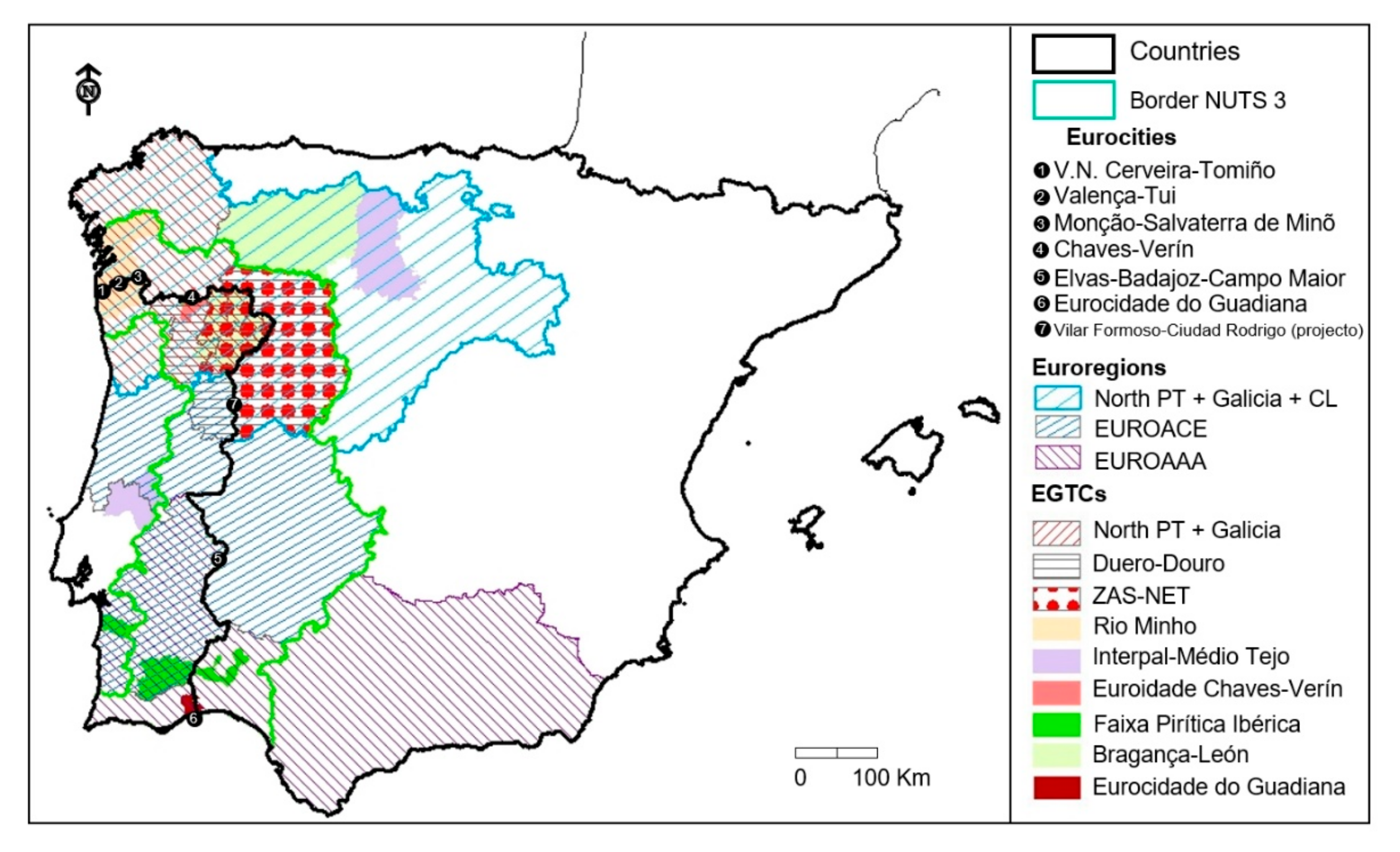
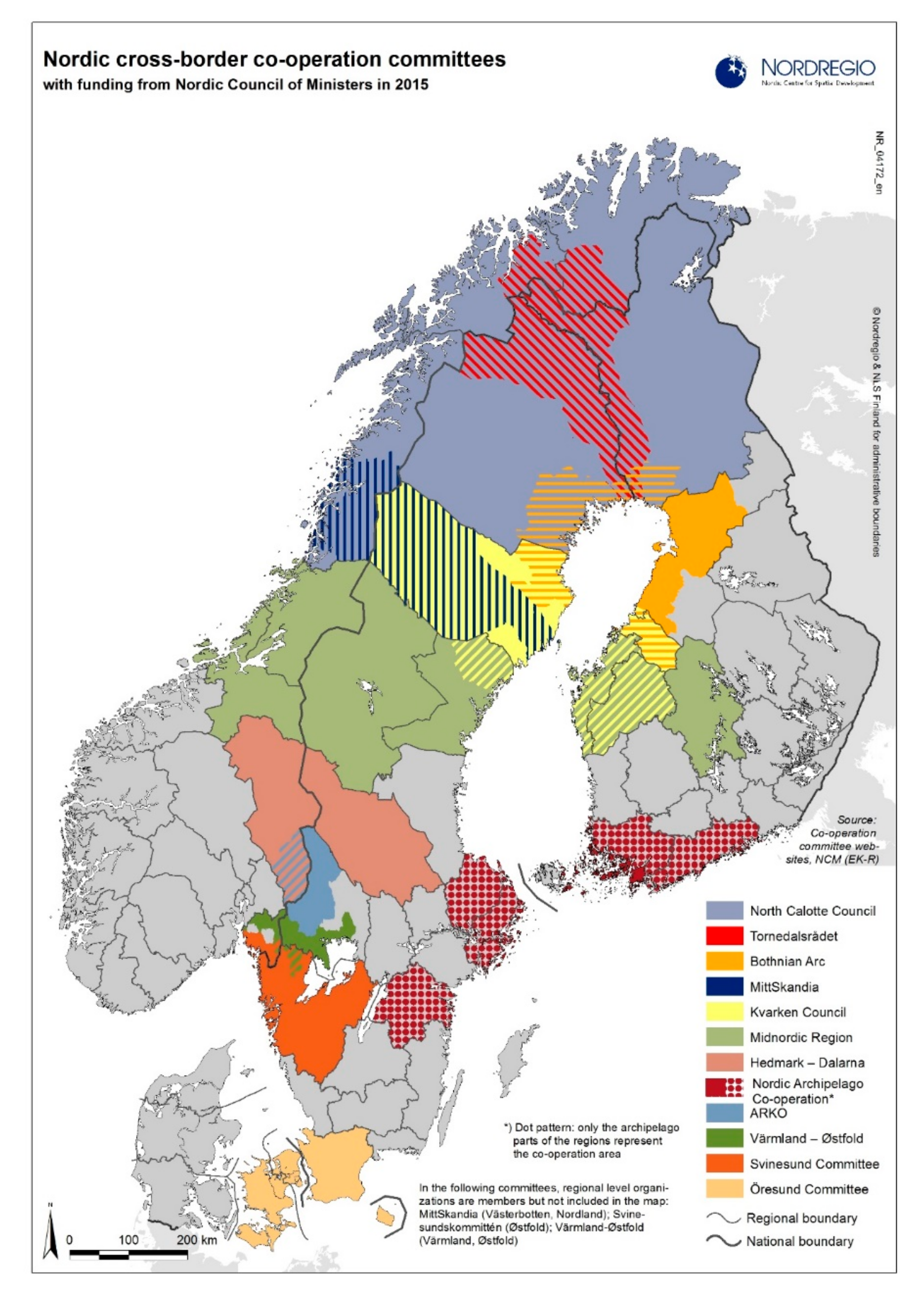
For the territorial cooperation and governance analytical dimension, the analysis of both case studies considered existing updated studies which have delimited several cross-border cooperation entities, both in Iberian (
Figure 1) and Scandinavian (
Figure 2) peninsulas, some of them made by the author. These entities can be viewed as concrete operative local/regional clusters of municipalities sharing common development interests with the municipalities located on the other side of the border, thus promoting cross-border cooperation for local and regional development [
47]. As can be seen in the following figures, both Norwegian and Portuguese case studies are engaged in ongoing cross-border cooperation agreements, some involving all municipalities (in Portugal), others only involving a few of them (Portugal and Norway). On the other hand, for the PT case study, the delimitation of the intermunicipal communities was also used, since it illustrates an ongoing operative governance clustering process between several municipalities in designing and implementing local and regional development processes.
The reason behind the selection of the Portuguese and Norwegian case-studies is two-fold. Firstly, is the vast knowledge collected over past decades on these rural territories that are quite similar in their depopulation trends and socioeconomic development needs in their national contexts. Secondly, is the fact that both territories are dominated by vast rural areas. Alentejo (PT), for instance, has always remained in the group of the less development EU regions since Portugal has entered in the currently known European Union. Despite not being the poorest region in Portugal, most of the Alentejo region faces the typical challenges of European rural areas, including depopulation, ageing and brain drain trends. A similar scenario is observed in the Norwegian case-study (Innlandet), which is a relatively new Norwegian region resulting from the joining of two former provinces (Hedmark + Oppland).
Finally, the examination of the accessibility and connectivity analytic dimension was based on the identification of the main urban areas and their connection via existing main roads and railroads, for both case studies. The classification of the urban areas adopted the ESPON urban categories of MEGAs and FUAs, which has been applied for the European territory in several ESPON reports. The classification of the urban areas per number of inhabitants used recent municipality data from national statistics. The goal was to identify small, medium and larger urban settlements in a national context. The delimitation of rivers, roads and railroads was gathered in existing GIS shapefiles. To facilitate the reading of the cartography, only national roads and highways were used, as they were enough to identify the main urban regional connections. The delimitation of the respective connectivity clusters was based on the geographic distance between several urban areas and the existence of road and/or railroad connectivity. In the end, the identified local ‘connectivity clusters’, have the potential to aggregate municipalities sharing similar development potentials and concerns in which the geographical proximity can facilitate the adoption of similar regional development strategies in an ever-globalised world.
5. The Policy Rationale for Development Clusters for Small Places
5.1. What Is a Small Place?
The United Nations (UN) 2030 Agenda’s ambitious and transformational vision embraces measures specifically focused on cities [
48]. Amongst these are the recognition of the need for sustainable urban development and planning to minimise the impact of cities on the global climate system. More importantly, however, this Agenda defines one main goal (11) dedicated to making: ‘cities and human settlements inclusive, safe, resilient and sustainable’. This goal encompasses several policy domains such as housing, transport, road safety, integrated and sustainable planning, cultural and natural heritage, risks, waste management, green spaces, social inclusion, etc. Likewise, the latest UN World Cities Report [
49], reveals that urban areas are now home to 55% of the world’s population (68% expected by 2050), making urbanization one of the twenty-first century’s most transformative trends globally [
50].
Nevertheless, there are no specific mentions of small cities and their potential role in implementing the UN Agenda 2030 goals which contemplate the need to devote resources to developing rural areas, by focusing on sustainable agriculture and rural infrastructure, whilst proposing “links between urban, peri-urban and rural areas by strengthening national and regional development planning” [
48] (p. 22). For Pink [
51], however, it is indispensable to consider urban settlements of all sizes to understand new urban social movements, even in the EU, in which 60% of the population lives in metropolitan regions, and 28% in the capital regions. Crucially, “smaller metropolitan areas and functional urban areas in the intermediate regions but also in predominantly rural areas have less functionalities mainly of transnational/national importance. In the rural areas and especially in remote areas and islands, small and medium sized towns are of fundamental importance for the territorial stability by providing crucial central services” [
52] (p. 10). This is a similar rationale to the proposed territorial cohesion cities’ policy approach for regional development at the national level towards more territorial cohesive territories [
16].
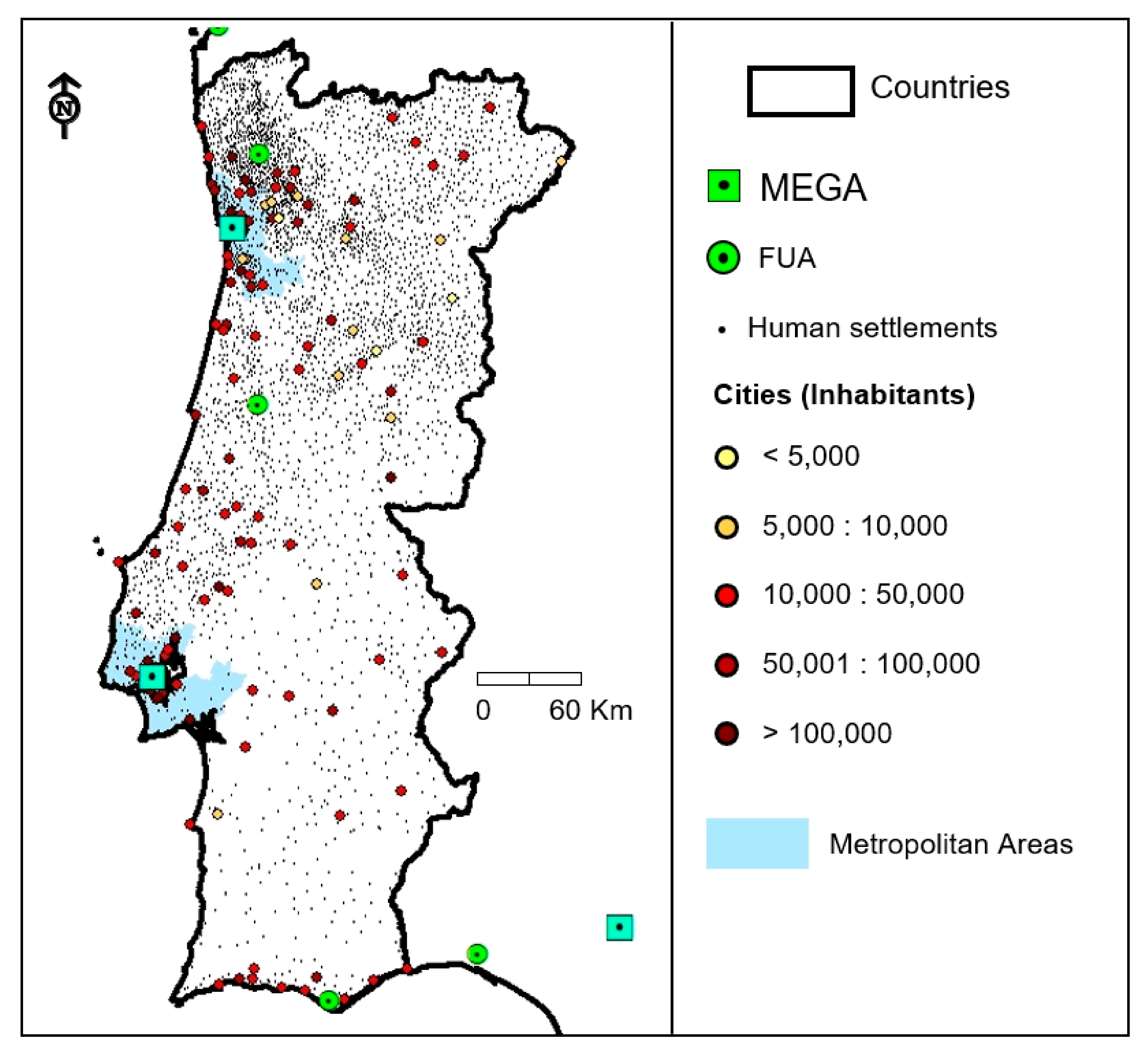
Based on the ESPON proposed typology of metropolitan areas, the regional and local functional urban areas (FUAs) could be regarded as small urban places at the regional level. These are widespread across Europe, commonly surrounded by non-metro regions which are often correlated with rural areas. In a national territorial context, however, some of these supposedly small urban places are considered medium-sized towns and regional capitals. Hence, the conceptual definition of what is a small regional place might vary from country to country and will probably never be agreed. For this paper, small places are all identified as small towns/settlements, under a national planning definition, located in a non-metro region and normally surrounded by rural areas. They are under the influence of a medium-sized town and/or a metropolitan urban area in a type of FUA(s).
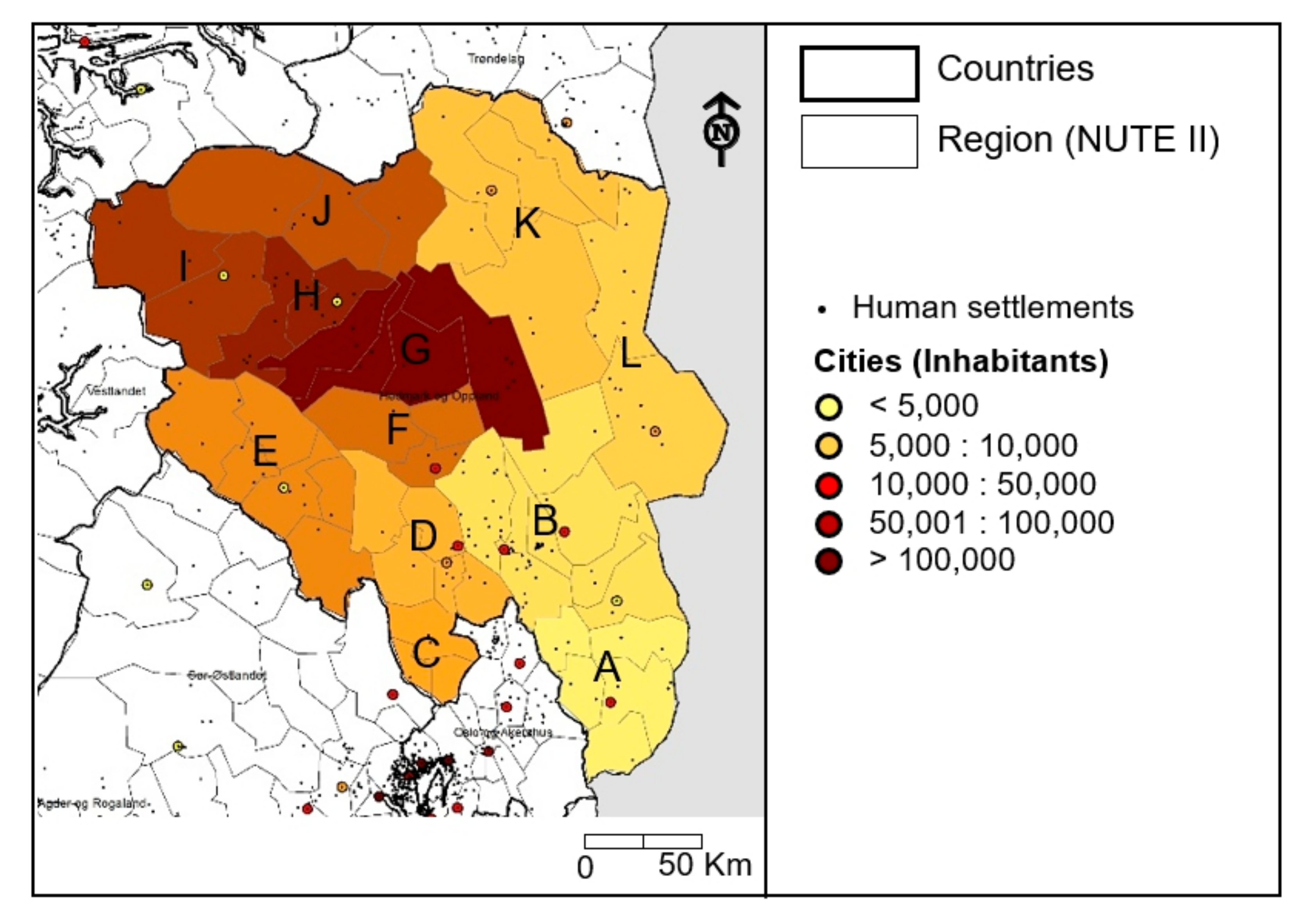
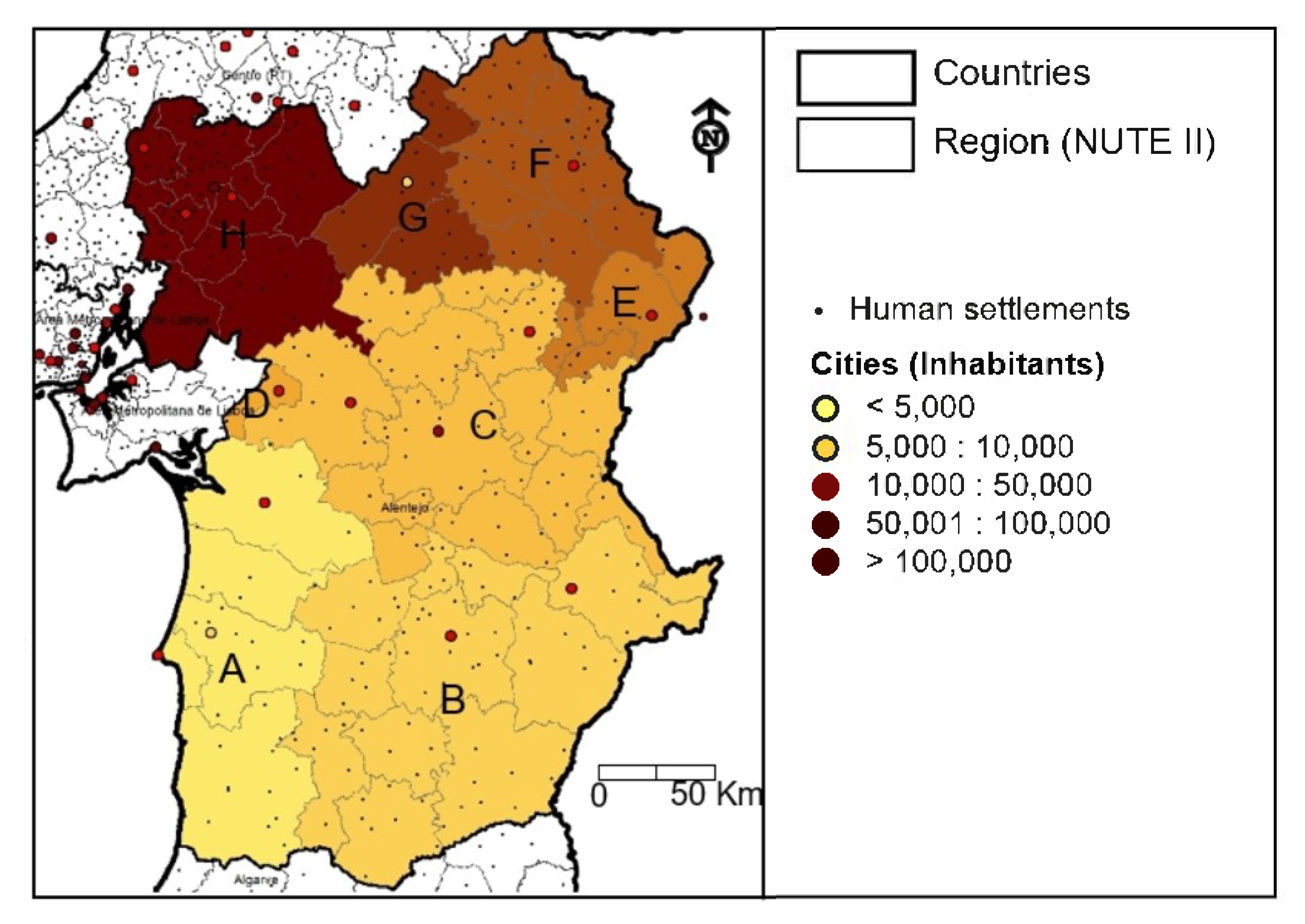
Under this definition, in the case of Portugal, a small place would also include cities with a population below 5000 inhabitants outside metropolitan areas (
Figure 3). In the case of countries such as Norway (
Figure 4), which has many urban settlements with fewer than a thousand inhabitants [
53], the criteria to define what is a small place can be slightly different from the Portuguese case. Nevertheless, in our understanding and based on previous work done in Norway [
54,
55], in this country any location with fewer than 5000 inhabitants can also be considered as a small place.
5.2. A Theoretical Framework to Identify Development Clusters for Small Places
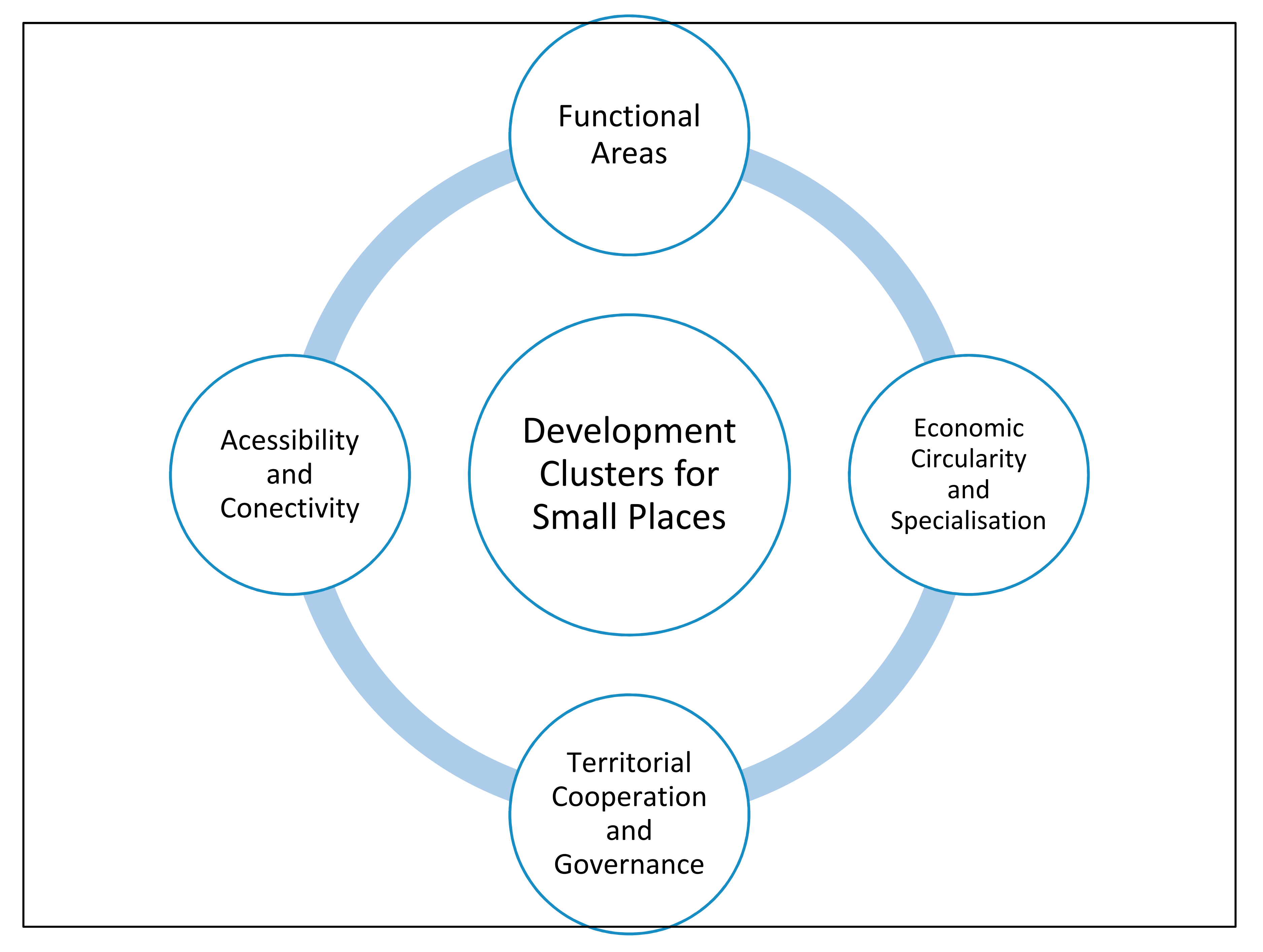
As seen from the Portuguese and Norwegian examples, small places can cover vast areas. As mentioned, these are, for the most part, rural lagging regions from a socioeconomic development standpoint. Therefore, their development process should be regarded as a priority within national and European development and cohesion policies (i.e., EU Cohesion Policy), in view of the overarching policy goal of territorial cohesion. The novelty of the policy approach proposed in this article is the potential advantages of contributing to help delimiting DCSP within European regions, to implement integrated, sustainable, innovative and place-based local/regional development policy strategies, taking into account that joining several small places in a unifying development strategy presents potential advantages to: (i) absorb more investment; (ii) empower local and regional stakeholders; (iii) implement a greener and circular economy; (iv) implement effective spatial development plans; and (v) increase regional resilience in the face of potential development challenges. Suffice it to say that clustering is a possible ‘remedy’ for boosting rural development, but clusters in general must arise bottom-up not top-down. Hence, charting the potential location and size of rural places is fine of course, but what is really needed is a sense of the extant clusters themselves and by what means might development policies intervene to promote their natural evolution. In this context, this paper advances four major criteria that can help to identify potential DCSP in a given territory (
Figure 5), and then takes two case studies (Alentejo and Innlandet) to better demonstrate the proposed theoretical approach.
Figure 5 presents an assembly of the proposed DCSP theoretical concepts. While sometimes analytically complementary, all these concepts contribute distinctively to delimit DCSP in the same rural area, as presented below. In a vivid illustration, territorial governance and cooperation delimited areas do not necessarily coincide with functional urban areas in rural areas. The same goes for areas with specific economic specialisation and territorial connectivity. This broadly multifaced and multicriteria policy orientation holds far-reaching implications to the challenges involved in the delimitation of operating DCSP. The Portuguese and Norwegian presented case studies serve more as concrete illustrations on how to apply the proposed DCSP policy rationale in two relatively large rural European areas, from a national standpoint. Ultimately, the case studies serve to the development of knowledge by presenting concrete case studies on how to identify DCSP in rural areas.
A: Functional Areas: are basically bounded spaces or geographical areas defined by a set of linkages, interactions and interdependencies [
56]. There are several methodologies to delimit these areas [
57]. Commonly, however, these areas are identified based on commuting data from daily workers. According to the OECD [
58], there are a variety of benefits that can be gained from functional areas including those related to: (i) employment policies; (ii) industrial development; (iii) public transport planning; (iv) housing needs; (v) cross-border commuting; and (vi) local government collaboration and restructuring. These functional areas are sometimes related to local labour market areas (LLMA), which are clearly identified for the Nordic Regions [
59].
Crucially, for the Innlandet case study area, there are 12 LLMAs (
Figure 6). These are clear differentiated clusters within these rural areas, based on commuting patterns that can help to delimit DCSP. Likewise, for the Alentejo case study eight similar LLMAs were identified, based on the interurban and rural-urban commuting flows [
60] (
Figure 7). Then again, the LLMAs coincide with the municipality borders, and sometimes can have slight variations in their size if more detailed data is available.
B: Economic Circularity and Specialisation: The notion of a circular economy envisions “intervention options for reducing consumption, improving the efficiency of production, introducing recycling and reuse for materials management, including new business models geared at waste prevention” [
61] (p. 128). The ESPON CIRCTER report [
62] (p. 14) has identified seven territorial factors affecting a circular economy: (i) land-based resources, (ii) agglomeration economies, (iii) accessibility conditions, (iv) knowledge- and (v) technology-based enablers, (vi) governance and institutional drivers, and (8) territorial milieus. The former (land-based resources), representing the core of the biotic circular flows within an area, can be, in our view, particularly important to delimit DCSP, alongside the ongoing regional development rationale of smart specialisation aiming at fostering entrepreneurial and innovative initiatives well-embedded in the local context [
63].
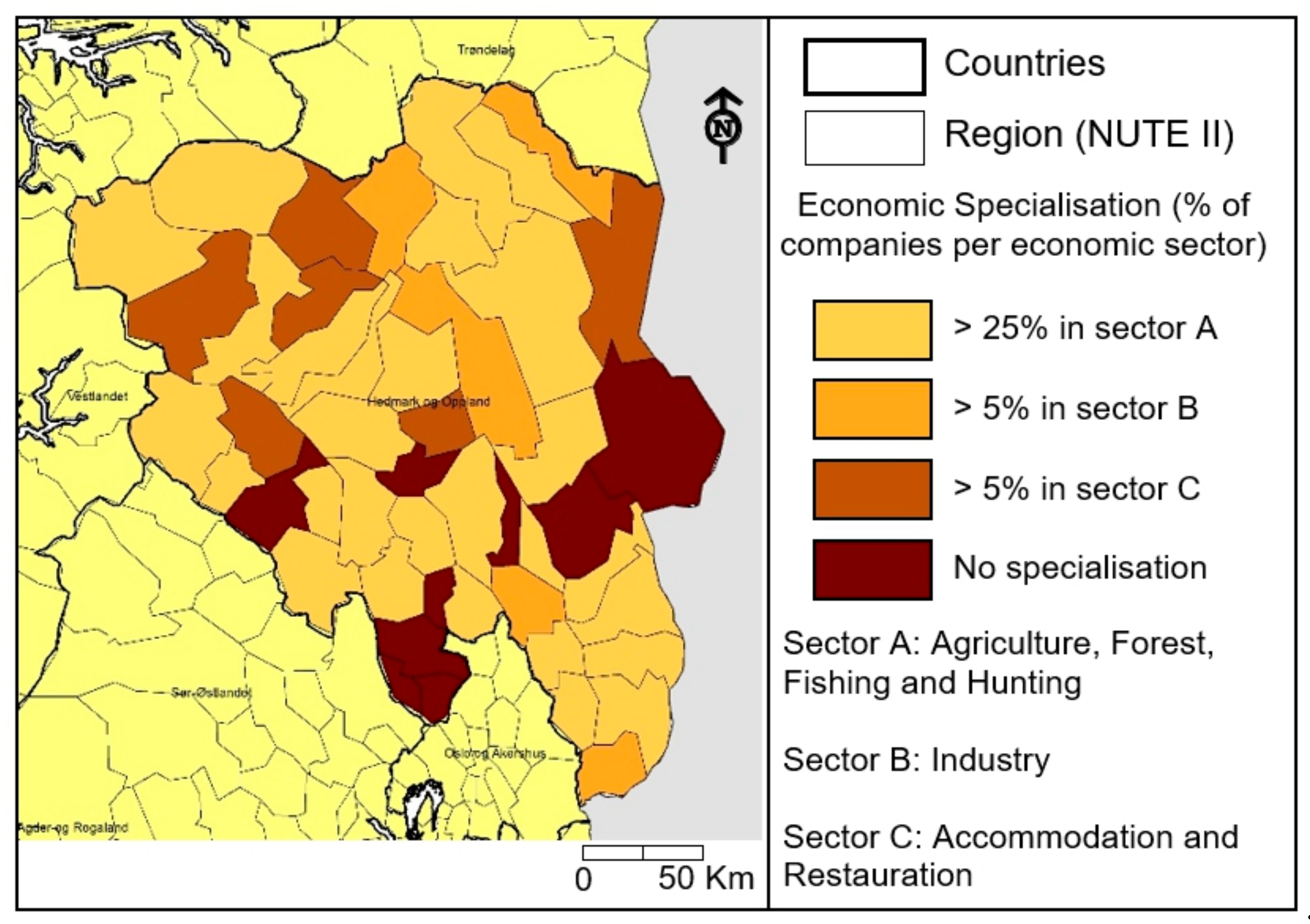
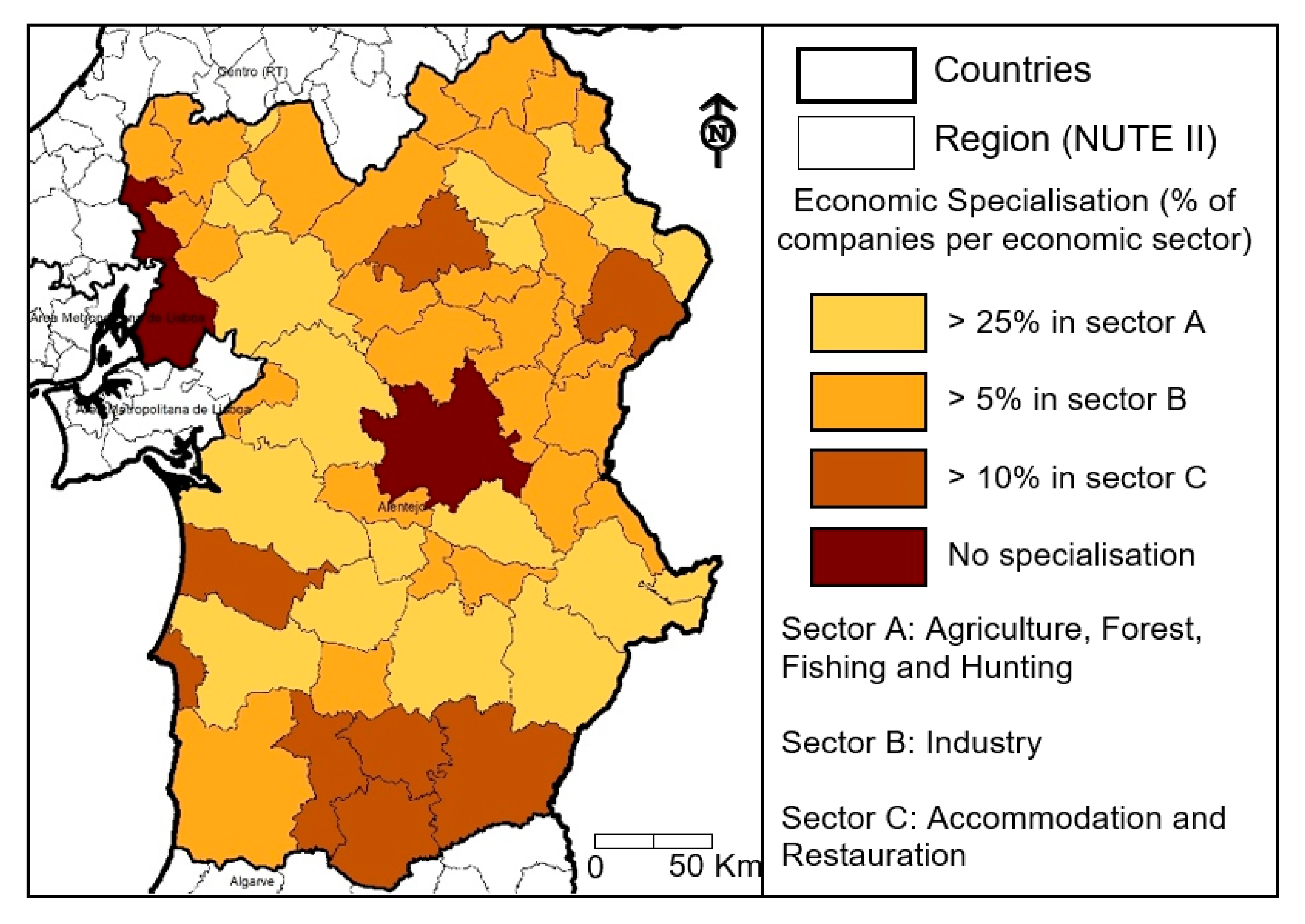
In a practical manner, however, the economic specialisation of a given territory can be spatialised with data related with the number of establishments per economic sector. This data exists per municipality. For simplicity sake and because only a few municipalities in both case studies are dominated by urban areas, it was decided to identify only three main economic activity sectors: Sector A: agriculture, forest, fishing and hunting; Sector B: industry; and Sector C: accommodation and restauration services (
Figure 8 and
Figure 9). The latter is normally associated with tourism related activities which demonstrate signs of economic diversity in rural areas. Here, the spatialization of dominant economic sectors per municipality presents several large connected clusters in both case studies, which helps to better identify the region’s economic mix. This information can be of use to better understand potential economic alliances and clusters within the region. Of course, the presence of more detail data on the municipalities’ industry mix, in specific economic sectors, can help to delimit DCSP with more precision. One eloquent example is the Marble Rout covering five Alentejo municipalities (Alandroal, Sousel, Borba, Estremoz and Vila Viçosa), in which this natural resource is explored since ancient times.
C: Territorial Cooperation and Governance: There are already several established territorial cooperation and governance processes and networks within regions for increasing possibilities to target investments and reduce regional disparities [
64]. This territorial cooperation process can entail “multiple domains—such as employment, housing, education, health, culture, urban planning” [
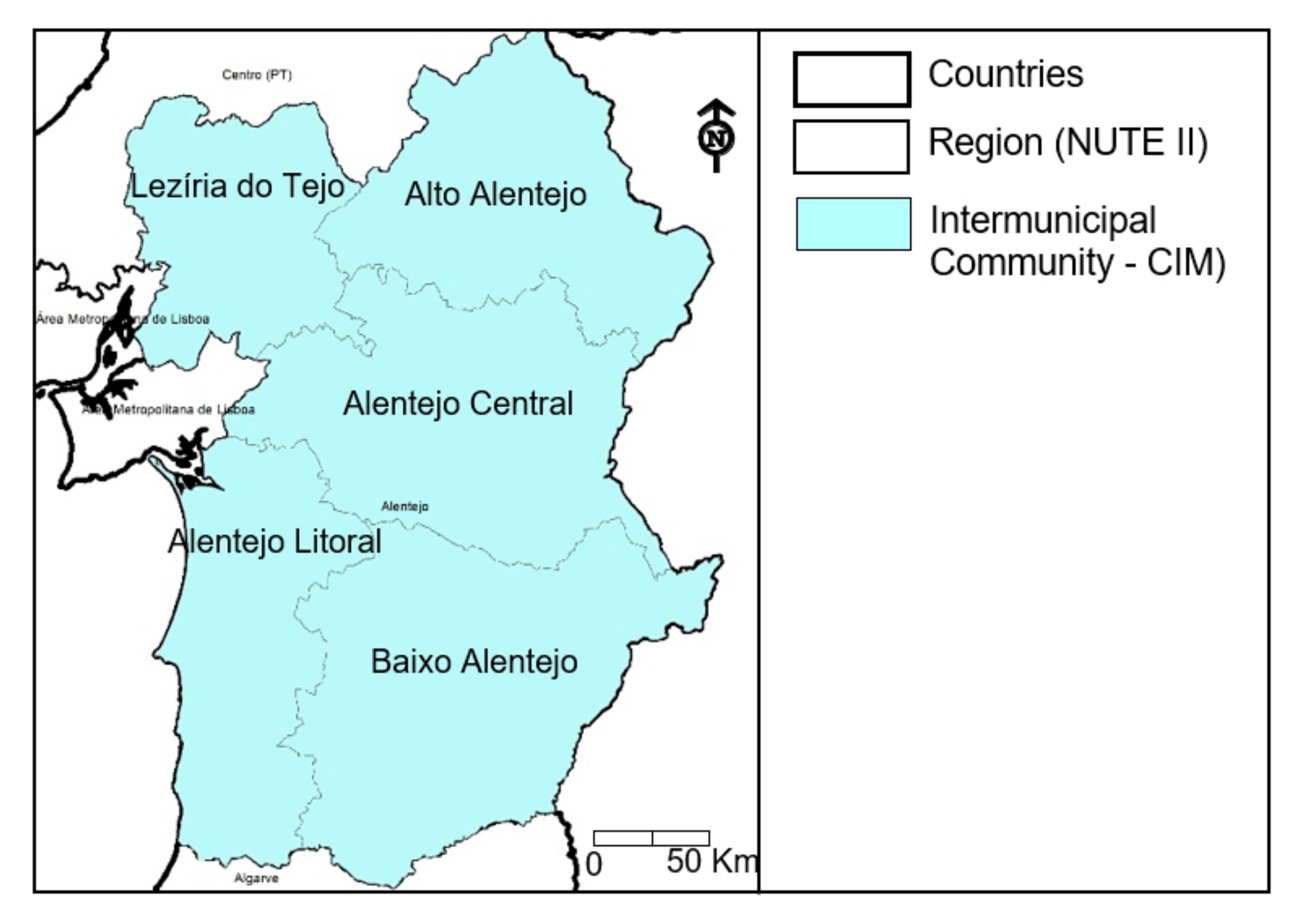
65] (p. 9), ultimately leading to increasing accountability, effectiveness and coherence of public policies’ implementation. In Portugal, for instance, 21 intermunicipal communities (CIMs) have been established on the continent by 2013, with close territorial connections with many of the 25 continental Nomenclature of territorial units for statistics (NUTS) 3 [
66] (
Figure 10). In short, the CIMs competences are similar to the metropolitan areas as they must ensure the coordination of municipal investments and services with an intermunicipal character, and the coordination between central government services and the municipalities in implementing basic sanitary infrastructures and managing social services. Hence, their delimitation plays a fundamental role in clustering municipalities in policy implementation, and they should be regarded when delimiting DCSP. Alongside, there are several cross-border cooperation entities with the neighbour Spanish regions implemented since 1990 [
47] in which all Alentejo municipalities are clustered, for instance in the participation of two Euroregions (EUROACE and EUROAAA). As expected, however, the municipalities adjacent to the Spanish borderline are more active in these cross-border cooperation processes and, hence, share similar development concerns [
67].
Similarly, several border Innlandet’ municipalities have established cross-border entities with the Swedish neighbour regions since the mid-1960s (
Figure 11). Therefore, these already matured municipality clusters should be regarded when delimiting DCSP. Curiously, and despite not having an inter-municipal layer of government, in Norway, inter-municipal cooperation is becoming an increasingly popular form of delivering services [
68]. In this context, all data related to potential inter-municipal collaboration in Innlandet could be used as an additional layer to contribute to delimiting DCSP.
D: Accessibility and connectivity: By determining the locational advantage of an area relative to all other areas, accessibility influences the degree in which a region can attract economic activities [
52]. In the context of delimiting DCSP, territorial accessibility and connectivity should be considered as it influences urban-rural catchment areas [
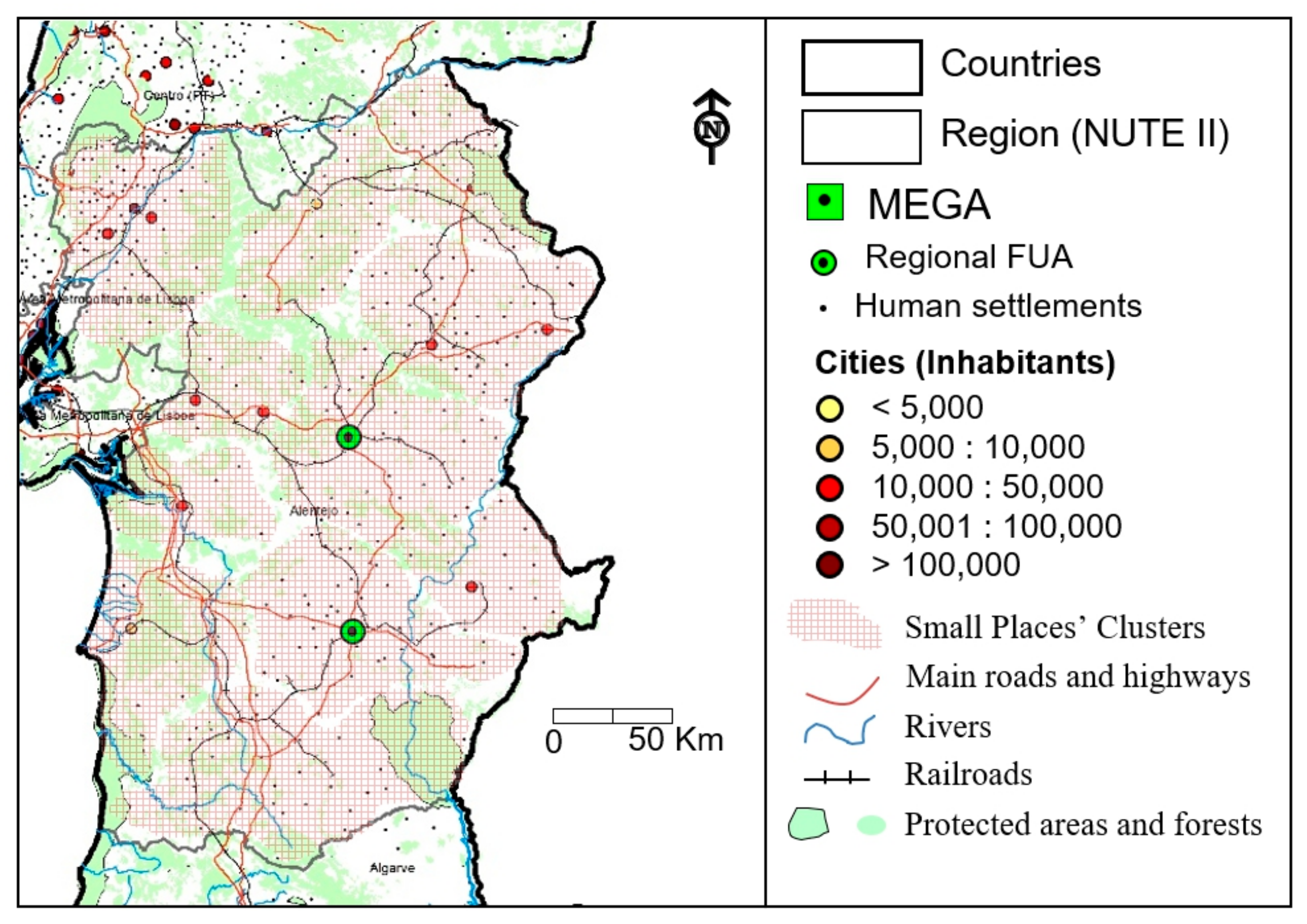
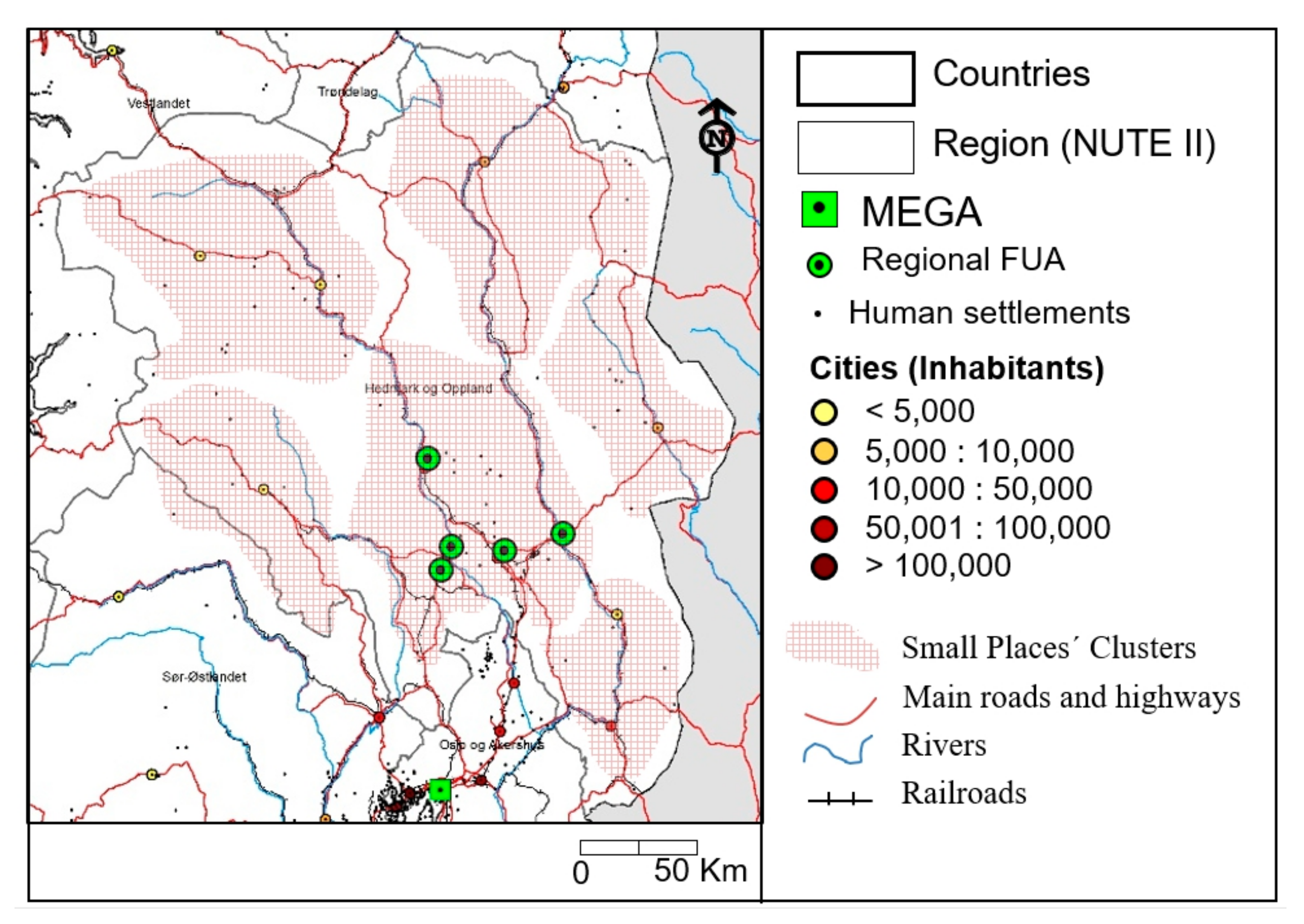
70]. Based on this criteria and available data, a few DCSP can be identified for the two specific case studies: Alentejo—Portugal (
Figure 12) and Innlandet (
Figure 13). In the former, eleven were identified, due to the relatively large area of Alentejo and its territorial idiosyncrasies. As can be seen, Alentejo has two regional FUAs, based on the ESPON criteria. Its surrounding territory defines a functional area closely accessible and with ongoing territorial cooperation processes. A similar situation can be identified for a few other ‘territorial dominant’ urban settlements that are by themselves (e.g., Alcácer do Sal) or in a ‘territorial alliance’ of proximity (e.g., Estremoz + Elvas or Silves + Santiago do Cacém). A similar picture is unveiled for the selected Norwegian region, in which a large cluster is delimited around five FUAs (Lillehammer + Ahmar + Elverum + Gjøvik + Raufoss) that are close together. This cluster contrasts with the remaining five DCSP that are dominated by either one (e.g., Trysil or Tynset) or a few (e.g., Otta + Lom) small urban settlements.
From a practical policy implementation perspective, the DCSP policy approach would help to design and implement distinct sub-regional operational programmes using EU (Cohesion Policy) and national regional development funding. These place-based and integrated territorial development approaches for each identified cluster should combine urban and rural development visions to untap, mobilise and capitalise under-explored territorial capital and potentials in each of these clusters. To set things in perspective, this policy approach has the potential advantage to stimulate new investment and skills targeted the specific territorial capital of the cluster. Moreover, it provides a broader and sounder platform to engage with a real and effective place-based and integrated development approach fuelled by increasing synergies and complementarities among all economic sectors and involved stakeholders. In the end, the aggregation of several small places in a combined local development strategy, could also increase their contribution to the territorial cohesion and competitiveness at the regional and national levels, by inverting depopulation trends and increasing socioeconomic development.
6. Discussion
In a globalisation and increasing urbanisation global context, rural areas face mounting socioeconomic and demographic (population decline and ageing) challenges, which can lead to the erosion of rural services and infrastructure provisions, as well as shrinking employment opportunities. As presented in
Section 2, these development trends are common in most European rural areas, and policy actions have been taken to tackle them, via EU funding policies and programmes. Currently, however, EU rural development policy priorities focus in supporting the economic performance of rural areas, whilst preserving, restoring and enhancing the environment, and promoting social inclusion processes. Profoundly influenced by this EU long-standing and mainstream ‘development dimensional triad’ approach of ‘economy + society + environment’, the current EU rural development policies also call for a more integrated, multisectoral and bottom-up policy approaches to engage local communities in their implementation.
Beset by mounting development challenges, European rural areas, however, continue, for the most part, to present below average national development trends when compared with non-rural areas, as recent studies on territorial cohesion trends in European countries have demonstrated [
16]. These studies have spurred alternative policy options to invert territorial exclusion trends in non-urbanised areas by, for instance, prioritizing the allocation of EU Cohesion Policy funding to medium-towns located in less socioeconomically developed European regions. In this context, this paper presents a complementary policy implementation approach which supports the allocation of EU cohesion and rural development funding to the needs of clustered municipalities located in rural areas, rather than stand-alone local/municipal policy interventions.
Since these policy interventions aiming at promoting regional development in small places are multisectoral, the paper proposes a theoretical framework supported by four distinct criteria which can be adapted for delimiting municipality clustering in small places for rural and regional development policy intervention. Understandably, the proposed criteria to delimit DCSP are closely interrelated. For instance, the accessibility and connectivity criterium is closely associated with the ‘functional areas’ criterium. In certain circumstances, one becomes more appropriate than the other for implementing specific development policies. For instance, the sound implementation of a regional green pubic transport system would benefit from a formation of ‘functional areas’ municipality cluster’ to apply for regional development funding, since it should cover the needs of daily commuters in a LLMA. Instead, the localisation of a new economic activity in a small place could beneficiate from the bringing together actors and entities from different municipalities close together geographically, which share similar development challenges and needs. In this case, the accessibility and connectivity criterium to delimit DCSP could be the most appropriate one.
Similarly, both accessibility/connectivity and functional areas criteria can, sometimes, be interrelated with the production and economical specialization criterium. There are, however, potential territorial development scenarios in which similar municipal economic specialisation areas do not align with the previously mentioned criteria. In this case, the request for policy funding to support a specific economic activity in small places would require the association of municipalities that share similar economic interests.
Finally, the use of the last criterium for delimiting DCSP is based on existing municipality clustering cooperation and governance experiments to deal with either specific or broader development needs. In the case of territorial cooperation agreements, it is well known that, in past decades, several cross-border cooperation entities have been set-up in most European border areas, with a specific goal to capitalise the added value associated with cross-border cooperation processes, and namely the need for increasing territorial integration. Hence, these already existing cross-border institutional arrangements could serve as optimal platforms to apply for rural/regional development funding for all the involved municipalities, not only for cross-border cooperation activities, but also for other policy goals which are relevant for their common development needs. The advantage here is that these municipality clusters are already established, and are in operation, in some cases, for several decades. A such, they already have administrative capacity to apply for funding. Likewise, existing regional intermunicipal associations can benefit from operative administrative structures to apply for regional development funding which benefit all involved municipalities to better address cross-sectoral challenges.
7. Conclusions
This article proposes a regional development rationale to foster a municipality clustering policy approach to mobilising existing potentials for the development of small places, with the goal to invert current territorial exclusion trends at the national level in Europe. Ultimately, this policy approach is sustained by the rationale that a shared development strategy for a few small places with common ecologic, institutional, and socioeconomic potentials within a vast region, could provide residents and economic activities wider capitalisation on development potentials and regional assets.
More fundamentally, a theoretical framework to delimit DCSP in a given territory would be sustained by four main interplaying components. Firstly, a cluster should have a certain amount of interactions, linkages and interdependencies, for instance in commuting patterns (functional areas). These can be combined between two or more small places when a medium-sized city is located far away and does not influence these commuting patterns. Secondly, a cluster should encompass the possibility to have an economic specialisation in a given sector and also the potential to implement an economic circularity plan for its territory. Thirdly, established territorial governance and cooperation processes in several domains between local entities could benefit the implementation of the strategy. Finally, existing physical accessibility links between small places (physical proximity and connectivity) should be considered to delimit these clusters.
Supported by this proposed theoretical framework and building upon previous research on both the Portuguese and Norwegian territories, two case studies served to analyse clustering potentials for the delimitation of DCSP: the Alentejo region in Portugal and the new Innlandet region (joining the former Hedmark + Oppland regions) in Norway. Both these regions are relatively large, encompassing distinct territorial characteristics, including vast rural and depopulated areas and a few FUAs (regional capitals and other medium-sized towns). Likewise, no large metropolitan area is present either in Alentejo or Innlandet. Based on the defined criteria, several clustering possibilities were identified based on the economic specialisation, past experiences from existing territorial cooperation agreements (including inter-municipal and cross-border), the identification of functional areas and related LLMAs, and finally the level of accessibility and connectivity between the analysed municipalities.
As seen, the proposed delimitation of DCSP in a rural area is particularly challenging as several combinations of potential beneficial policy clustering are possible. The potential advantages of municipal clustering in small places, over current mainstream regional development rationales to implement endogenous rural development in a supra-municipal scale are three-fold: Firstly, inter-municipal cooperation in socioeconomic and demographic lagging areas could gain in joining forces to tackle local, regional and supra-regional development challenges that are mutually common, and that a single municipality cannot resolve in isolation. Secondly, this clustering approach proposed by the DCSP rationale can lead to increasing institutional thickness and policy influence, towards a more territorial cohesive region since, by joining forces, small places can increase the possibilities to attract much needed development funding in an EU policy framework which increasingly favours large and medium urban settlements, universally seen as engines of development. For instance, a border municipality might find advantages in collaborating with other border municipalities in cross-border cooperation processes.
On the other hand, the same municipality might find high policy clustering possibilities to collaborate with other municipalities with similar economic activity mixes. Thirdly, the DCSP approach can complement the Territorial Cohesion Cities policy rationale which supports the priority channelling EU Cohesion funding to medium-towns located in less socioeconomic developed regions. More concretely, by promoting a municipality clustering approach, the DCSP can complement the Territorial Cohesion Cities theoretical proposal by making it easier to justify, from a regional development standpoint, the allocation of reasonable amounts of EU funding to municipality clusters dominated by small places, rather than the current scenario which allocates funding to standalone municipal development strategies.
As in similar/other theoretical policy designs, the DCSP policy proposal for implementing development potentials and opportunities for small places through an integrated and place-based approach, needs to be formally piloted to assess its feasibility and effectiveness. At the same time, it requires a bottom-up rather than top-down policy approach to be successful. This effectiveness, however, would depend on several factors such as the amount of investment placed in each cluster development strategy and the institutional framework and administrative capacity to implement it. The latter is especially relevant since small places are normally undermined in terms of the human capital domain, which tends to concentrate in medium and large urban agglomerations. Hence, there is a need for pro-active involvement of external actors to help in designing and implementing DCSP’ strategies, as an effective policy tool to invest in territorial exclusion trends at the national level.


