Article

The Impact of a Lack of Government Strategies for Sustainable Water Management and Land Use Planning on the Hydrology of Water Bodies: Lessons Learned from the Disappearance of the Aculeo Lagoon in Central Chile

by
Rodrigo Valdés-Pineda
1,2,
Pablo A. Garcia-Chevesich
1,3,4,*,
Alberto J. Alaniz
5,
Héctor L. Venegas-Quiñones
1,
Juan B. Valdés
1 and
Roberto Pizarro
6,7
1
Department of Hydrology and Atmospheric Sciences, University of Arizona, Tucson, AZ 85721, USA
2
Water Management Group, Piteau Associates, 2500 North Tucson Boulevard, Suite 100, Tucson, AZ 85716, USA
3
Department of Civil and Environmental Engineering, Colorado School of Mines, Golden, CO 80401, USA
4
Intergovernmental Hydrological Program, United Nations Educational, Scientific, and Cultural Organization, Montevideo 11200, Uruguay
5
Department of Geographic Engineering, Faculty of Engineering, University of Santiago (USACH), Santiago, Chile
6
Cátedra Unesco en Hidrología de Superficie, University of Talca, Mailbox 747, Avenida Lircay s/n, Talca 3460000, Chile
7
Centro Nacional de Excelencia para la Industria de la Madera, (CENAMAD), Pontificia Universidad Católica de Chile, Av. Vicuña Mackenna 4860, Santiago, Chile
*
Author to whom correspondence should be addressed.
Sustainability 2022, 14(1), 413; https://doi.org/10.3390/su14010413
Submission received: 18 November 2021 / Revised: 20 December 2021 / Accepted: 28 December 2021 / Published: 31 December 2021

Abstract

:
Several studies have focused on why the Aculeo Lagoon in central Chile disappeared, with a recent one concluding that a lack of precipitation was the main cause, bringing tremendous political consequences as it supported the argument that the government is not responsible for this environmental, economic, and social disaster. In this study, we evaluated in detail the socio-economic history of the watershed, the past climate and its effects on the lagoon’s water levels (including precipitation recycling effects), anthropogenic modifications to the lagoon’s water balance, the evolution of water rights and demands, and inaccurate estimates of sustainable groundwater extraction volumes from regional aquifers. This analysis has revealed novel and undisputable evidence that this natural body of water disappeared primarily because of anthropogenic factors (mostly river deviations and aquifer pumping) that, combined with the effects of less than a decade with below-normal precipitation, had a severe impact on this natural lagoon–aquifer system.

1. Introduction

Lakes and similar surface water bodies represent an important part of the hydrologic cycle of many watersheds around the world, providing not only water resources for human activities, but also recreation and ecosystem services, among others [1]. However, many lakes worldwide are drastically disappearing in recent years due to a combination of excessive withdrawals and/or climate change effects. In fact, large natural surface bodies of water such as the Aral Sea in Central Asia, Chad Lake in Africa, Figuibine Lake in Mali, Poopo Lake in Bolivia, Assal Lake in Djibouti, and Urmia Lake in Iran, among many other cases, have gone dry during the last decade, resulting in dramatic economic, social, and ecologic consequences (e.g., [2,3]).
The Aculeo Lagoon in central Chile is among the above-mentioned increasing group of hydrological events. Its name comes from the Mapudungun dialect Acum-Leu, which means “where the rivers end”. In fact, many small direct tributaries historically used to recharge the lagoon every winter (rainy) season, with the Pintué River being the most important direct affluent to the body of water, followed by Las Cabras Creek. All the relevant tributaries are currently deviated upstream or simply dry due to the decrease in local water tables.
Unsustainable watershed management practices led to an accelerated population growth and land use changes that largely impacted the water balance of this small lagoon–aquifer system, which went completely dry in early 2018. Though there have been many studies focusing on the Aculeo watershed during the last few decades (e.g., [4,5,6,7,8,9,10,11,12,13], among many others), the anthropogenic modifications applied to the watershed and their impact on water resources have only been a topic of discussion in recent investigations [14,15,16,17]. Herein, we have included a detailed socio-economic history of the Aculeo watershed, the history of past climate and its effects on the lagoon’s water levels, the strong precipitation recycling effects that this small body of water used to experience, and a history of anthropogenic modifications to the lagoon’s water balance, ending with a detailed section on how water demands and the allocation of water rights have increased over time; all of the above show that the impact to the lagoon cannot be exclusively attributed to a persistent reduction in rainfall, but most importantly to the anthropogenic factor and its role in accelerating the drying process. Although Alaniz et al. [14], Venegas-Quiñones et al. [15], and Valdés-Pineda et al. [16] concluded that human activities were the main factor leading to the disappearance of this important body of water, Barría et al. [17] concluded that a reduction in annual rainfall produced this hydrological, ecological, and social disaster, bringing serious political consequences as the Government of Chile was assumed to be non-responsible for the problem after that study. This investigation aimed to clarify several important factors that Barría et al. [17] did not consider in their evaluation, including a series of analyses never conducted before, to provide undisputable scientific evidence of the causes that led to the complete disappearance of this unique natural ecosystem.

2. Materials and Methods
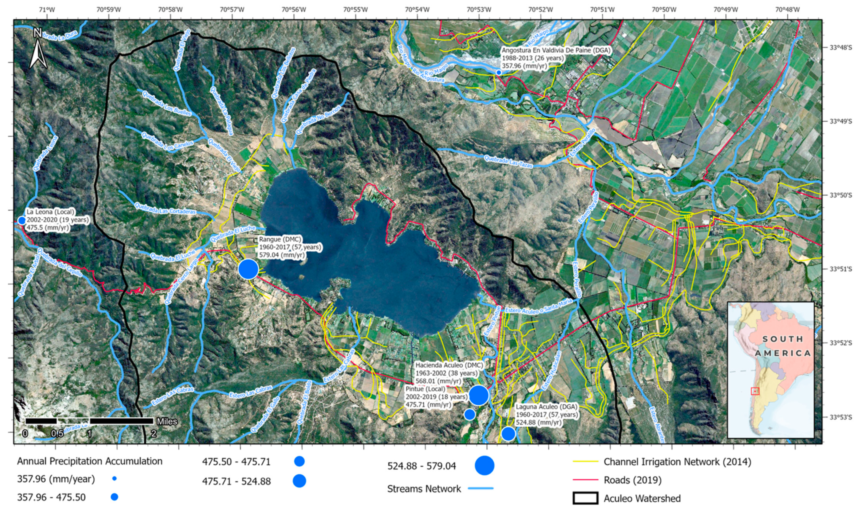
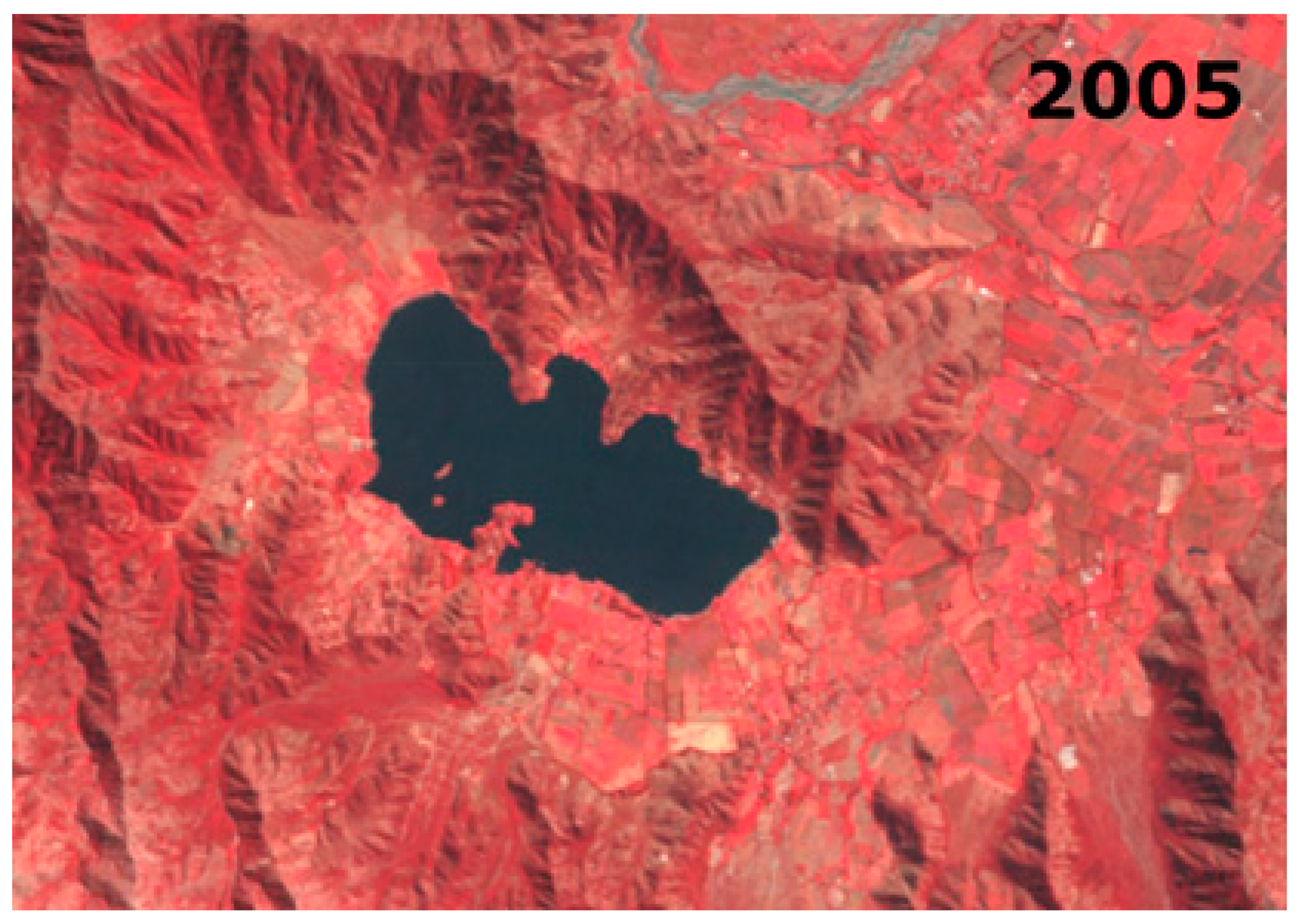
2.1. Case Study

The Aculeo Lagoon was located about 50 km southwest of Santiago (33°50′ S–70°54′ W), in the Paine District of the Metropolitan administrative Region. The lagoon’s wet surface used to be situated at around 356 m.a.s.l., between the inner foothills of the La Costa Mountain range. As previously mentioned, the reasons leading to the complete disappearance of this important body of water continues to be highly controversial in Chile, with two main theories currently being considered: (1) the lagoon dried out because of a decrease in annual precipitation (as concluded by Barría et al. [17]); and (2) land use changes that resulted in dramatic increases in water consumption depleted the lagoon–aquifer system deep enough to set water table levels below the lagoon’s bottom (as concluded by previous studies [14,15,16]). Though both variables act in combination in each scenario, Aculeo represents an important case study because similar situations are occurring in most aquifers in central and southern Chile, i.e., uncertainty related to diversions or pumping of natural streams and aquifers, and land use changes responsibilities on water levels depletions. Herein, we considered natural climatic tendencies and anthropogenic actions to determine without any doubt who played the main role in the disappearance of the Aculeo Lagoon, serving as a methodological example to be applied to other aquifers undergoing similar processes in central Chile.

2.2. Data Gathering and Methods
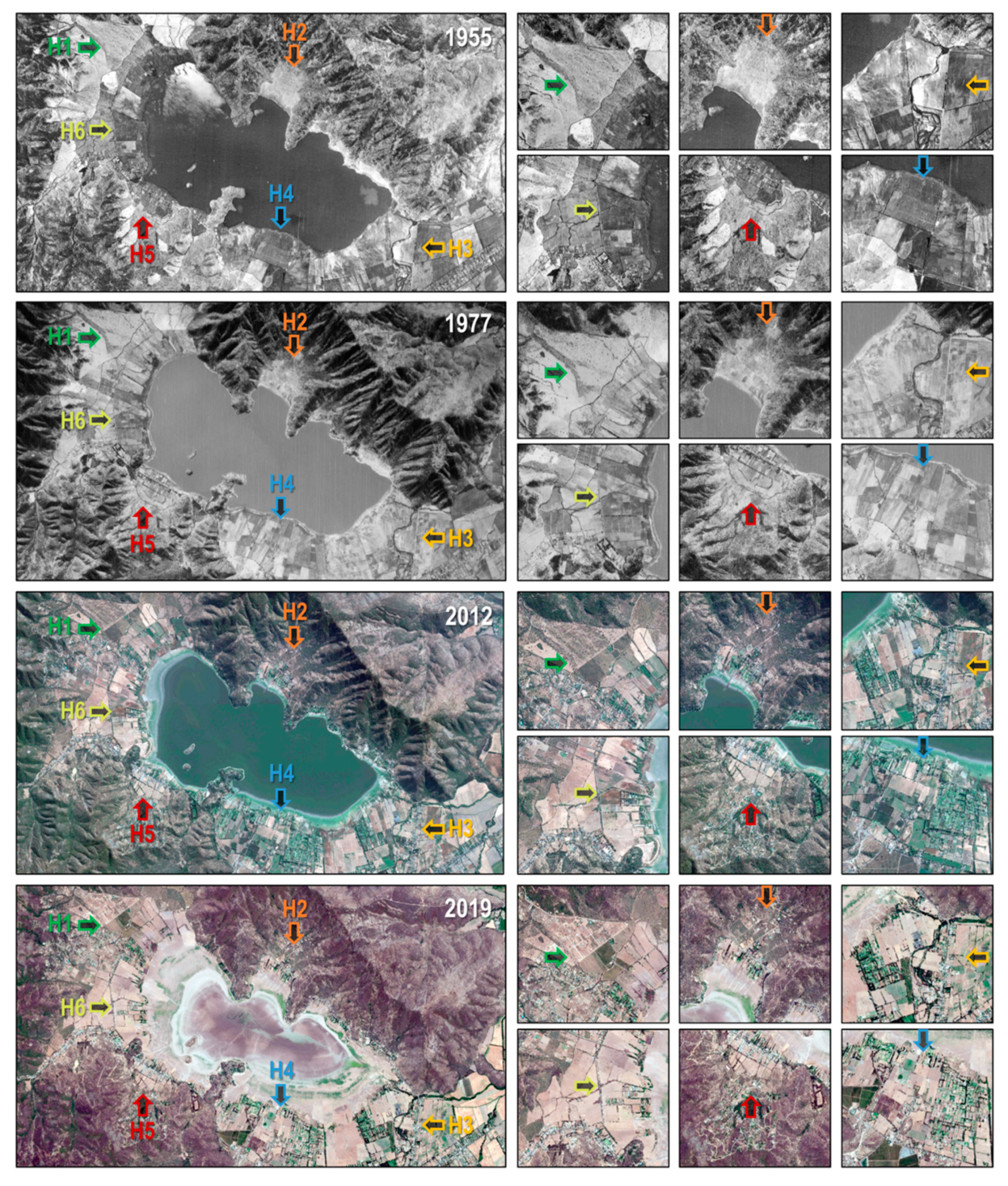
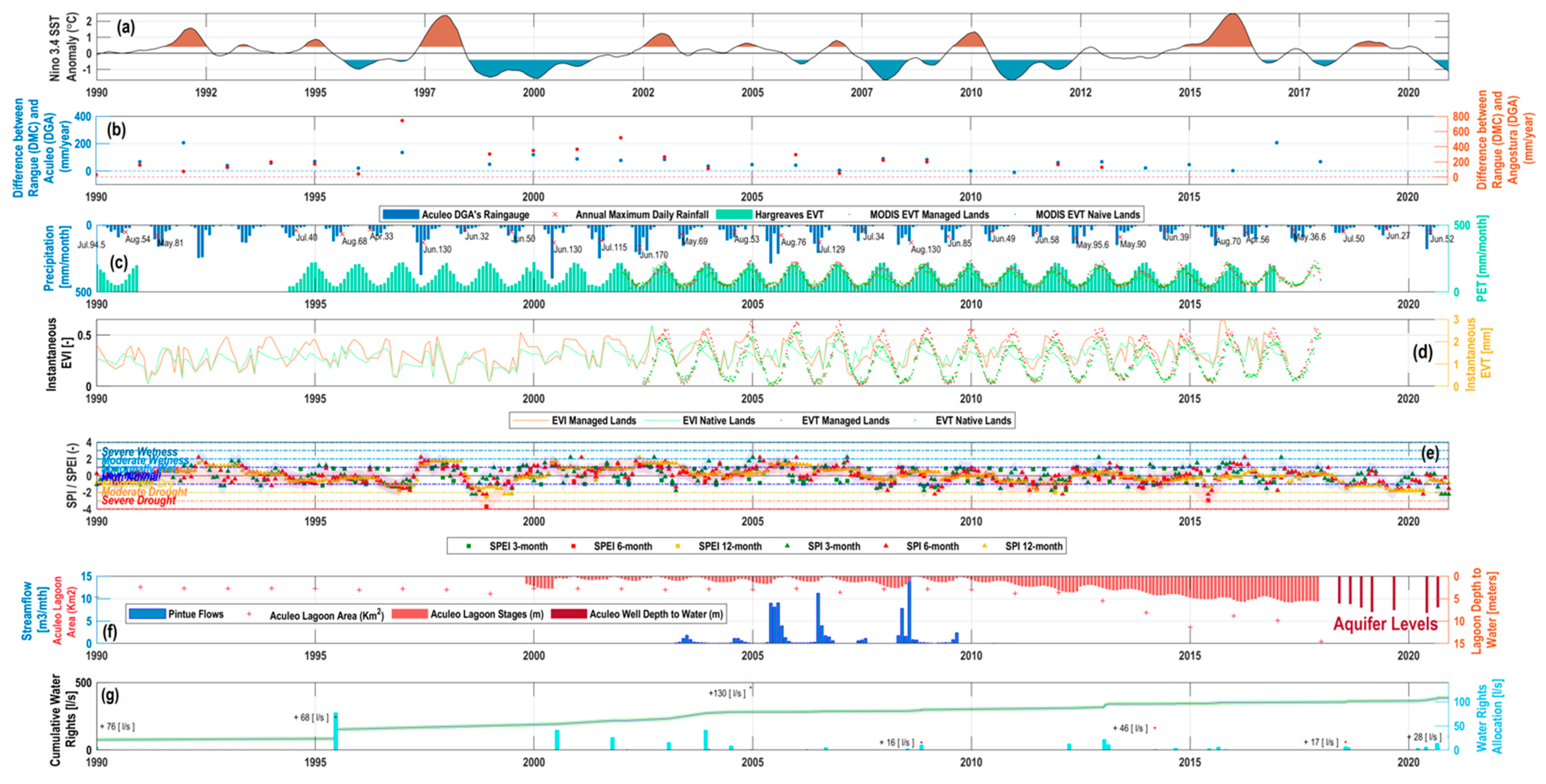
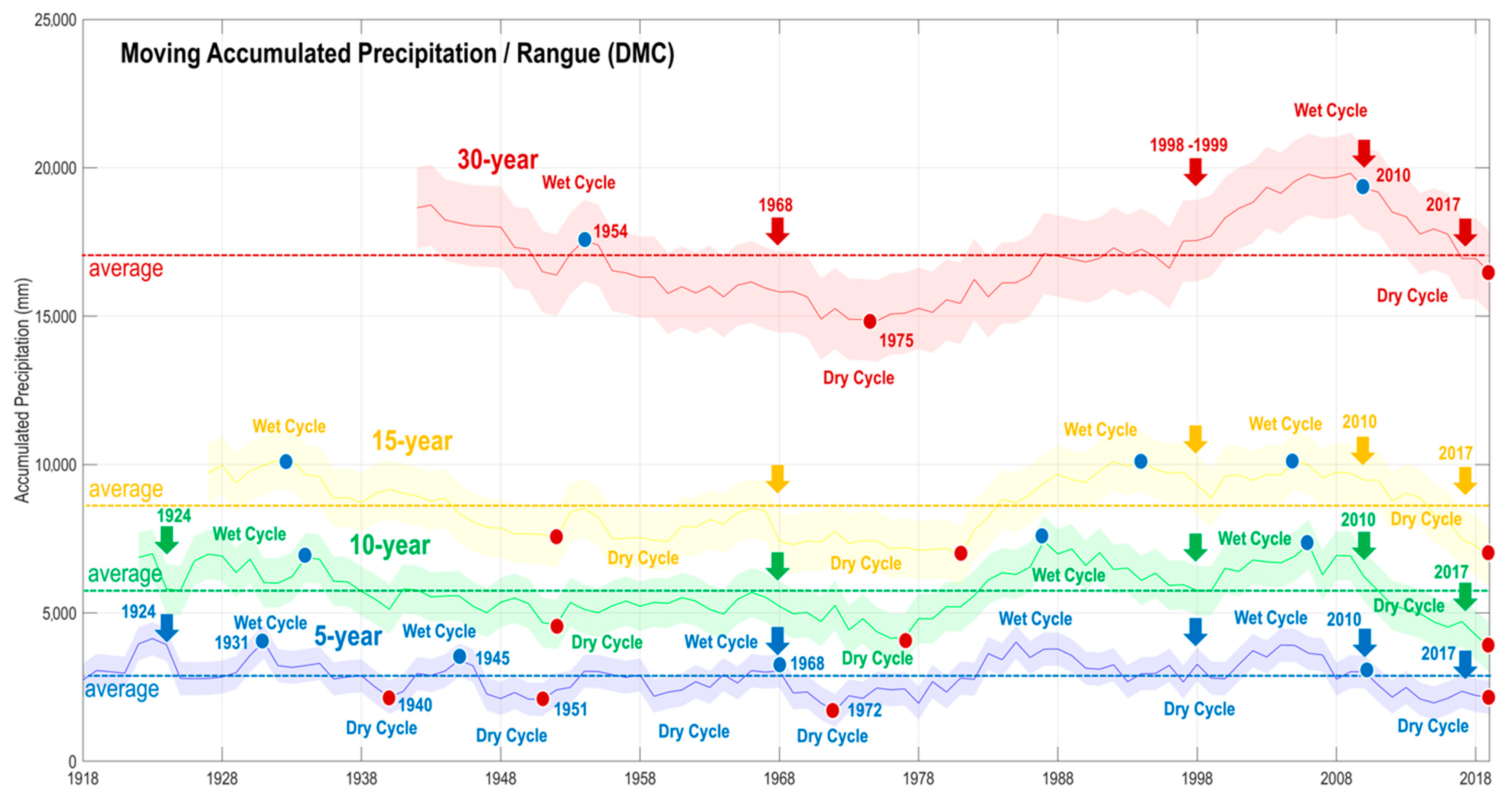
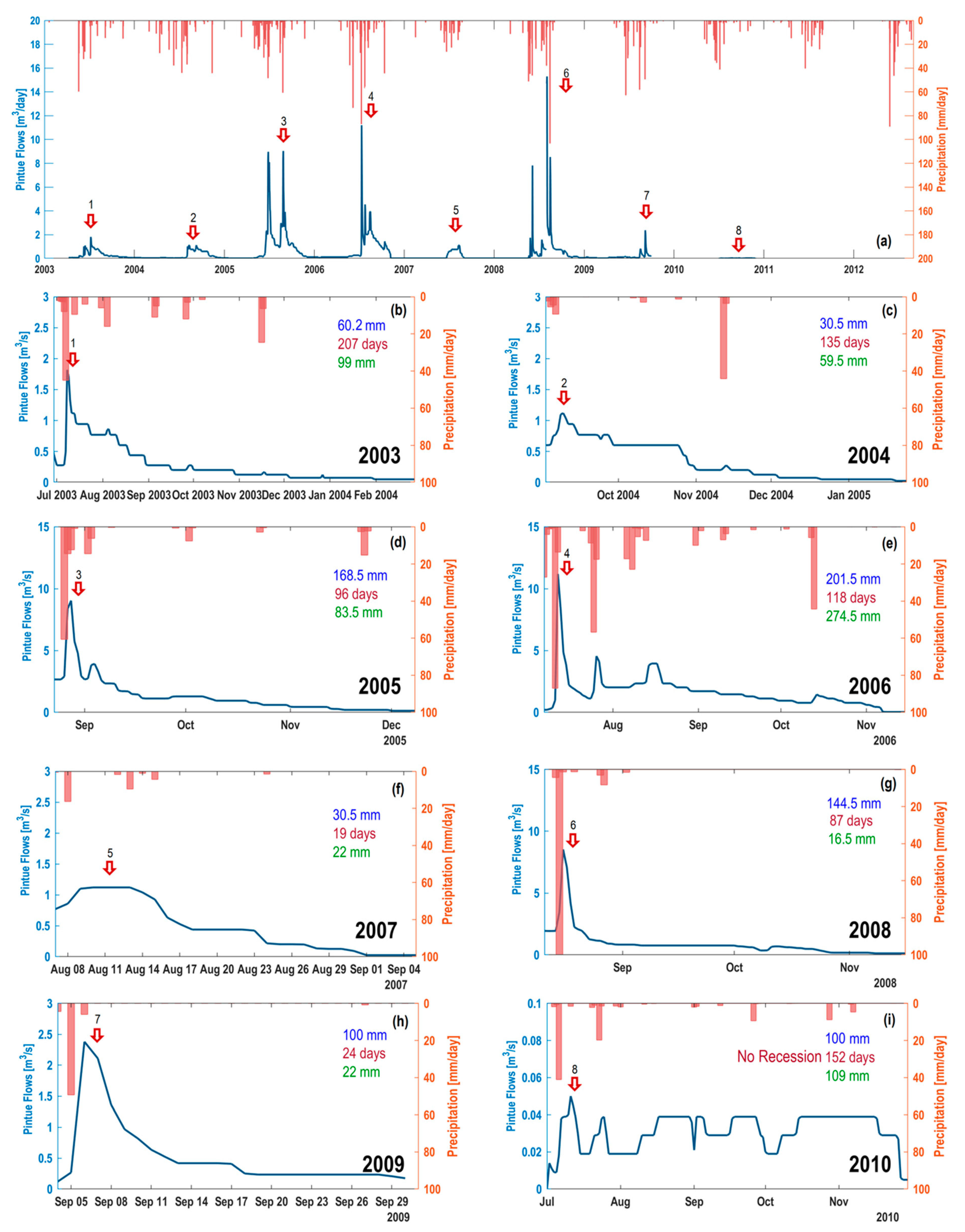
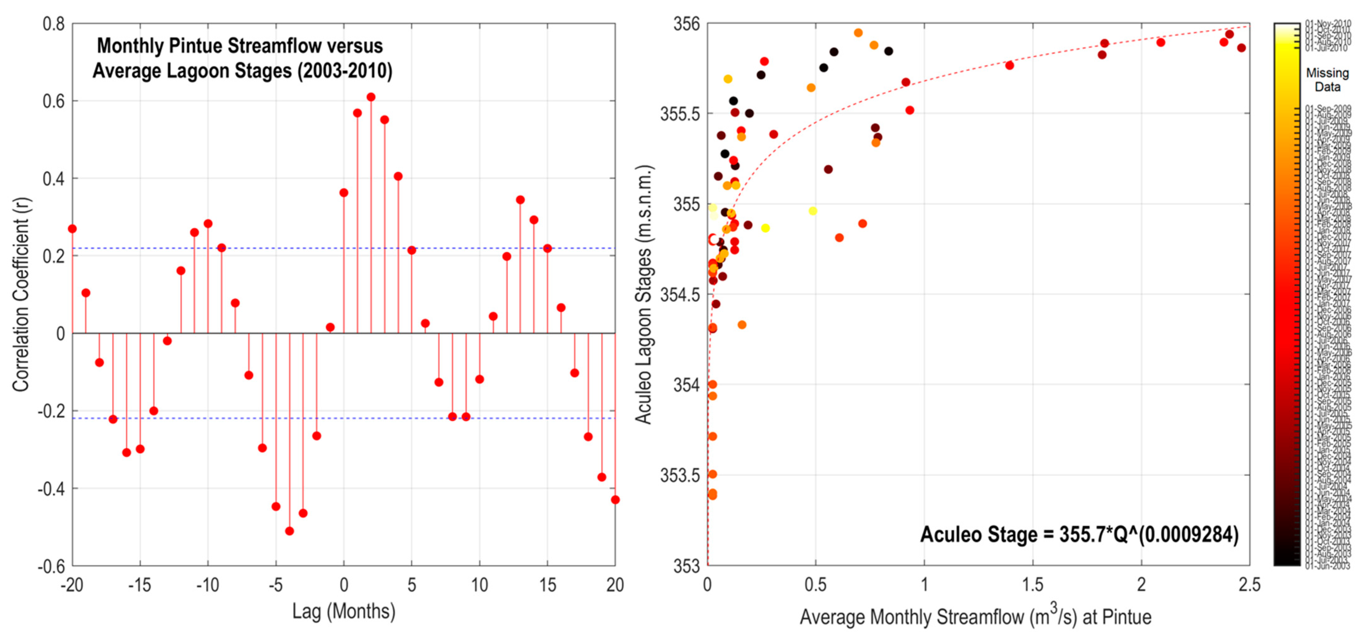
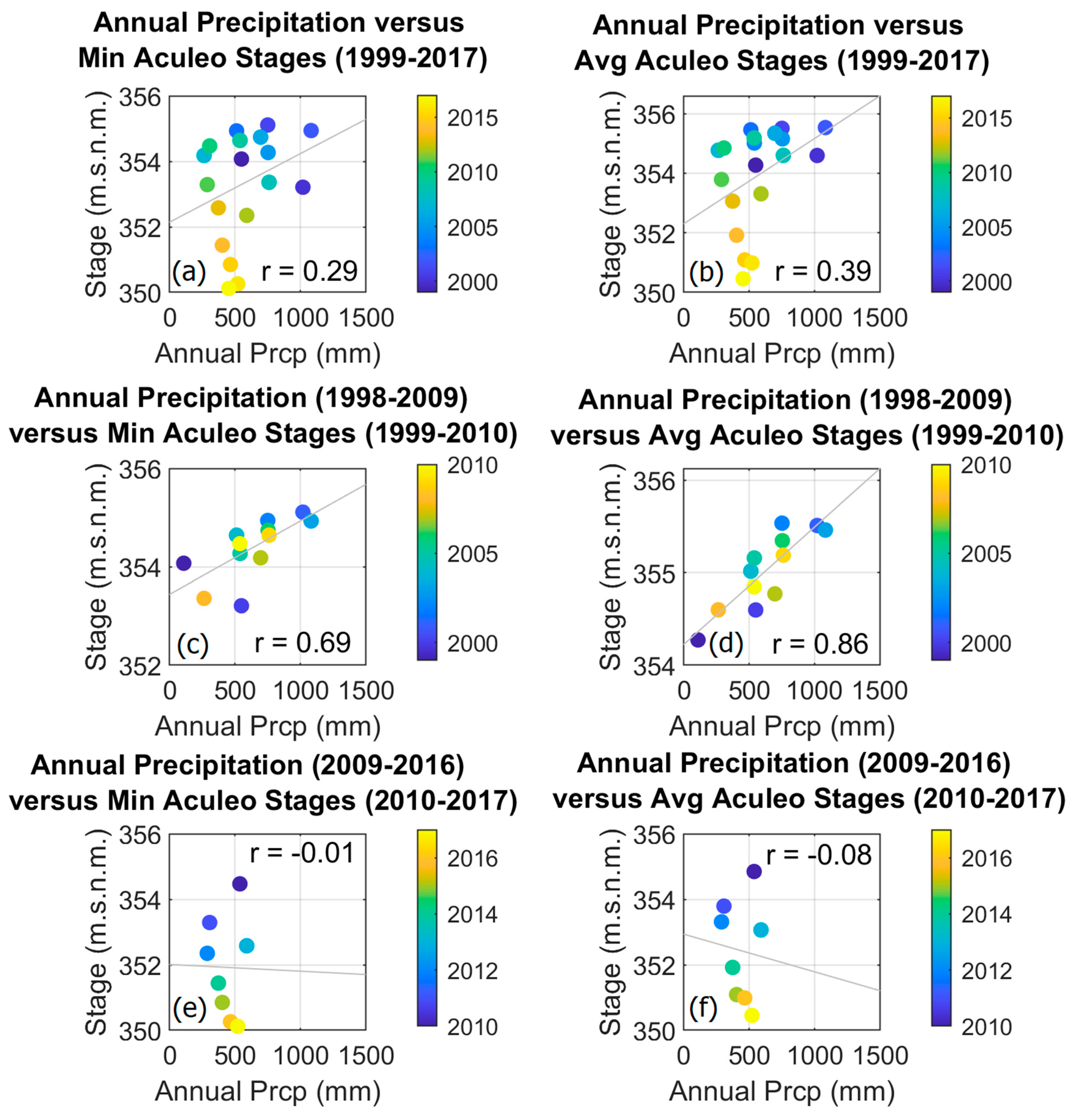
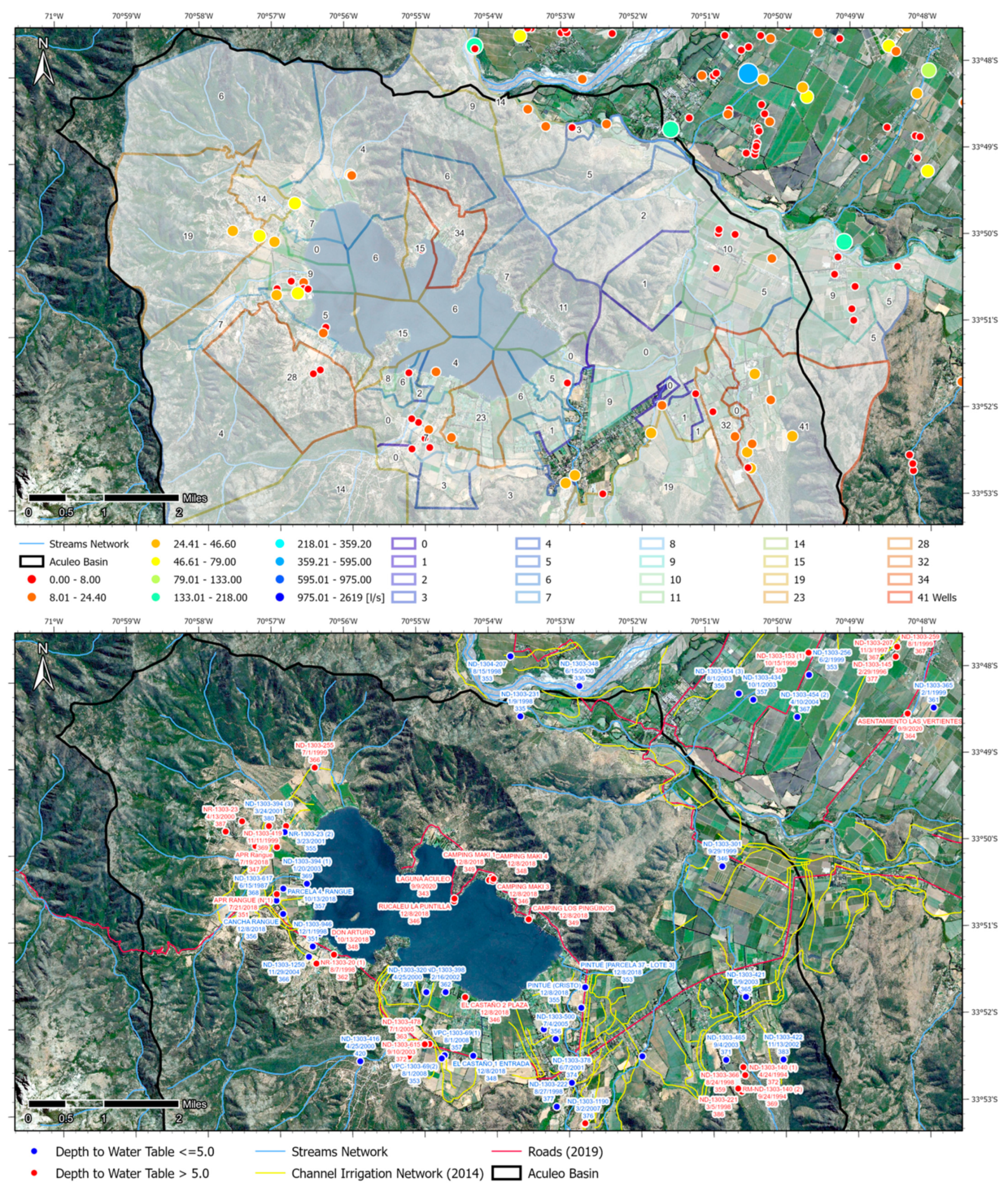
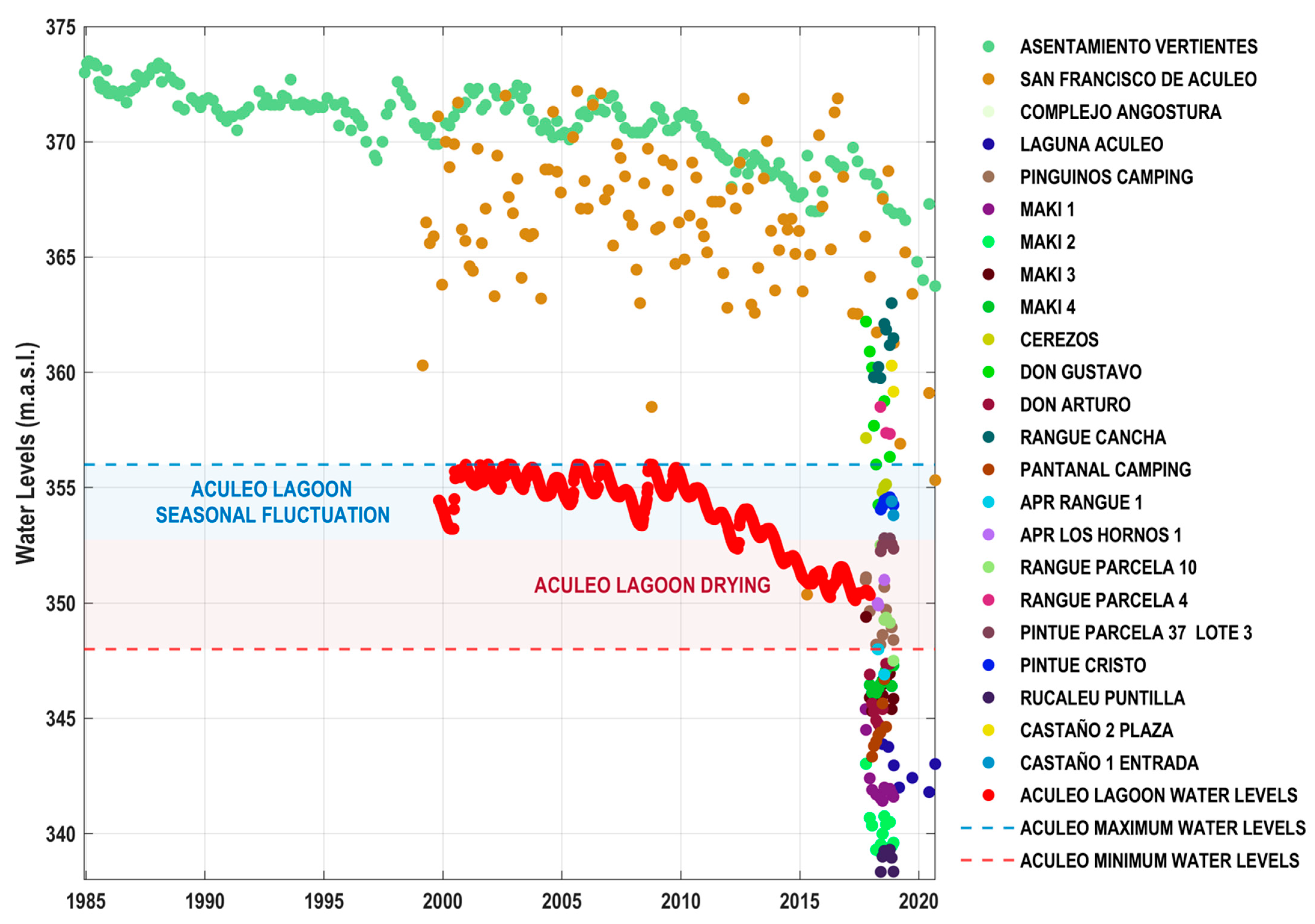
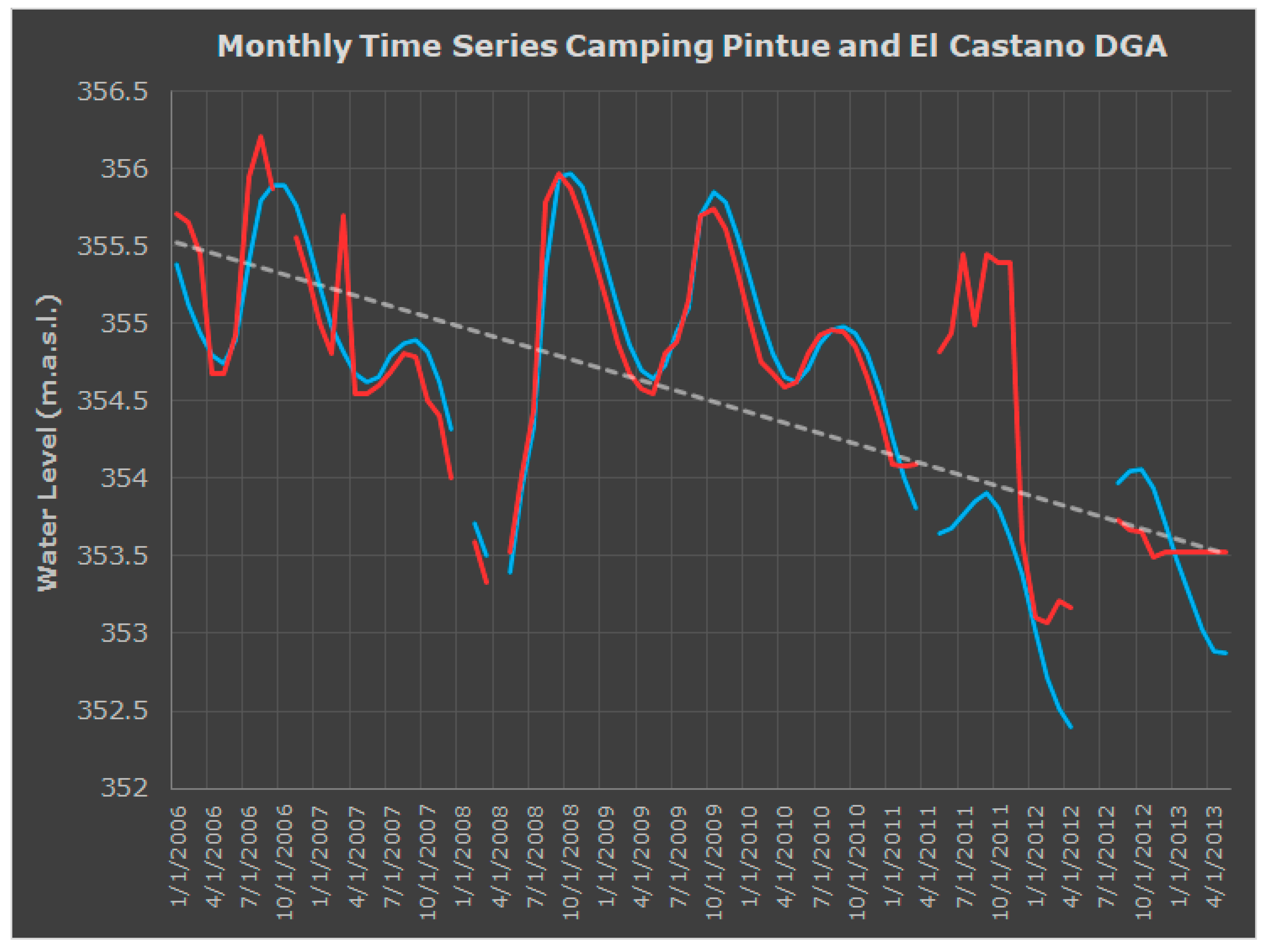
An aerial view of the lagoon’s wet surface taken in 2007 is shown in Figure 1. The same Figure shows the most relevant rain gauges with their corresponding historic average annual precipitation accumulation, including Rangue from Chile’s Meteorological Directorate (DMC, #33060), Laguna de Aculeo from General Water Directorate (DGA, #05716005-5), and Angostura DGA (#05716004-7) stations. Annual precipitation accumulation differences among those rain gauges were compared to detect possible precipitation recycling effects. Note that complete annual records after 2002 are not available for Hacienda Aculeo (DMC#330037); therefore, they do not include the current megadrought that central Chile has been experiencing during the last decade (e.g., [18]), not being the case for all other rain gauges shown in the Figure. For instance, Rangue DMC and Hacienda Aculeo DMC have an average annual accumulation of 627.49 and 580.10 mm, respectively, considering all the matching records between 1963 and 2002, even though the longest records were documented at the former rain gauge (1913 to date).
Figure 1 also includes the stream network (affluents, all of them being currently deviated for anthropic reasons, as previously mentioned), irrigation channels (2014), roads (2019), and data obtained from the corresponding public institutions that generated the products in the background.
Monthly streamflow records at Pintué Creek were obtained from DGA station #05716003-9, to compare them with the lagoon’s water levels (using El Castaño DGA #330156 station and Pintué Campground’s personal station) and wet surface, the latter being calculated using Landsat 8. After the drying occurred on 2018, aquifer levels were estimated using a DGA monitoring well (DGA #05716014-4) installed right next to the lagoon’s lowest topographic point at the northern portion of the water body. In particular, a recession analysis of instantaneous streamflow records of Pintué River (2003 through 2010) was compared to rainfall information to detect patterns and the occurrence of upstream deviations.
Land uses at the Aculeo watershed during different years (1955, 1977, 2012, and 2019) were analyzed and compared. This information was obtained from the National Military Institute through their HYCON Flight (1955_R-5_F-755), the National Aero-Photogrammetric Service through their National Aero-Photogrammetric Flight (CH_60_1977), and Landsat 7 and 8. Additionally, land use and socio-economic changes at the Aculeo watershed were evaluated through an extensive literature review that included the period between the mid-1800s and the present days. Such review considered scientific journal publications, undergraduate and graduate theses, and government reports, as well as testimonials from locals born and raised in the area.
The above literature review also considered a palaeoclimatological analysis, including regional climate variability in the Southern Westerly Wind Belt, with the intention of briefly describing the climatic history of the watershed for the last 9500 cal yr B.P. and find out whether this body of water went dry before, as it did in early 2018. Other important climatic variables considered in this study included a time series of Sea Surface Temperature (obtained from the ENSO 3.4 area), monthly precipitation accumulation with each yearly cycle to determine month and accumulation of maximum annual 24-h rainfall. Similarly, monthly evapotranspiration was calculated using the Hargreaves method [19] and estimated for managed versus native lands within the Aculeo watershed. Instantaneous Enhanced Vegetation Index (EVI) and Evapotranspiration (EVT) for managed and native lands within the Aculeo watershed were obtained from MODIS. Drought classifications for 3, 6, and 12 months were determined using the Standardized Precipitation Index (SPI) and the Standardized Precipitation Evapotranspiration Index (SPEI). Both drought indices were calculated using the previously mentioned available precipitation and evapotranspiration records.
Moving accumulated precipitation for 5-, 10-, 15-, and 30-year periods was calculated using Rangue DMC’s annual records, identifying drought events that occurred in central Chile during the last century. This analysis included uncertainty bands, determined using two standard deviations calculated over the whole time series of 5-, 10-, 15-, and 30-year rainfall accumulation.
An “Impulse Response Function, or IRF” (cross-correlation based) between monthly average streamflow at Pintué River versus the lagoon stages was built to determine the response time (months) of the lagoon stages. Similarly, a correlation between annual precipitation accumulation (Rangue DMC) and the lagoon’s minimum and average water levels was developed to identify differences in linearity between the two variables before and after major land use changes and river deviations occurred.
Monthly long-term groundwater levels from DGA’s monitoring wells and shallow pumping wells measured during 2017 were included in this analysis based on previous reports, to evaluate the temporal evolution of the aquifer and compare them with the lagoon’s water levels, identifying seasonal variations (fluctuations) and drying anomalies.
Finally, the allocation of surface and groundwater rights over time in the Aculeo watershed were obtained from DGA’s database. This analysis included a historical evaluation of regional and local groundwater management and aquifer planning. Similarly, the number of wells in the area was obtained from the 2017 National Census (Polygons). Groundwater levels in the Aculeo valley were obtained from all 55 pumping and monitoring wells registered by DGA.

3. Results

Land uses at the Aculeo watershed during 1955, 1977, 2012, and 2019 are shown in Figure 2. The areas on the right side of each photograph represent six hotspots (H1 to H6) surrounding the lagoon’s area, which have revealed important land use changes during recent years (see Appendix A).
Figure 3 illustrates: (a) a time series of Sea Surface Temperature in the ENSO 3.4 area; (b) the annual precipitation accumulation differences between Rangue DMC and Aculeo DGA rain gauges (blue dots), as well as between Rangue DMC and Angostura DGA (red dots); (c) (right-axis) the monthly precipitation accumulation (mm/month) for the Aculeo DGA rain gauge with each yearly cycle showing the month and accumulation of maximum annual 24-h rainfall; (left-axis) monthly evapotranspiration (green bars) estimated for managed (red markers) versus native (green markers) lands within the Aculeo catchment; (d) the drought classification for 3, 6, and 12 months (SPI and SPEI), based on precipitation and evapotranspiration records presented in (c); (e) the streamflow records (m3/month) at Pintué Creek (blue bars), and the lagoon’s water levels (red bars) and wet surface (red crosses); (f) the accumulated allocation of water rights (left-axis) and allocated water rights over time (right-axis) in the Aculeo Lagoon; and (g) the EVI (left-axis) and EVT (right-axis) for managed and native lands within the Aculeo catchment.
Figure 4 shows the moving accumulated precipitation for the 5-, 10-, 15-, and 30-year periods. The years marked with arrows represent the drought events that occurred in central Chile during the last century.
Figure 5 illustrates: (a) the instantaneous streamflow records at Pintué River and the daily rainfall accumulation from the Aculeo DGA rain gauge (the closest rain gauge to the Pintué Stream gauge with available daily records), between 2003 and 2013. Hydrographs (b) through (i) show streamflow recession curves generated from eight peak streamflow events recorded at Pintué’s vehicular crossing bridge (a total of ten events recorded between 2003 and 2010). The Figure also includes the two-week antecedent accumulated precipitation (blue), the duration of streamflow recession in days (red), and the accumulated precipitation during the recession period (green).
Figure 6 (left) shows the Impulse Response Function (cross-correlation based) between the monthly average streamflow at Pintué River and the lagoon stages. The peak streamflow observed at Pintué River leads the response of Aculeo Lagoon stages from one to four months. Figure 6 (right) illustrates the most significant two-month correlation between streamflow at Pintué River and stages at the lagoon, represented by a power function. The marker-color gradient represents the monthly dates used for the construction of the IRF, which are displayed on the color bar.
Figure 7 illustrates the correlation between annual precipitation accumulation (Rangue DMC) and the lagoon’s minimum (left) and average (right) water levels (documented at Pintué Campground, a personal station), for (a and b) the 1998–2017 period (all available data merged), (c and d) the 1998–2009 period (before major land use changes and river deviations occurred), and (e and f) the 2010–2017 period (after major land use changes and river deviations occurred), respectively.
Finally, the water rights (L/s) assigned in the Aculeo District and number of wells are shown in Figure 8 (top). The polygon divisions observed over the lagoon’s area correspond to pumping wells located in areas surrounding the water body. The same Figure 8 (bottom) shows the groundwater levels in Aculeo from all 55 pumping and monitoring wells registered by DGA. Each well included in the Figure provides the groundwater levels documented at specific dates.
The monthly long-term groundwater levels from DGA’s monitoring wells (Asentamiento Vertientes, San Francisco de Aculeo, and Laguna Aculeo), and the monthly groundwater levels from shallow pumping wells measured during 2017 [20] are shown in Figure 9, with the red markers representing the lagoon’s water levels, the blue bands representing the seasonal variation (fluctuation), and the red bands representing the drying anomalies. Additionally, Table 1 shows the history of technical reports and legal resolutions involved in the process of regional aquifers identification, including the Aculeo watershed.
Though uncertainty is always a factor, we are confident that our results are scientifically reliable.

4. Discussion

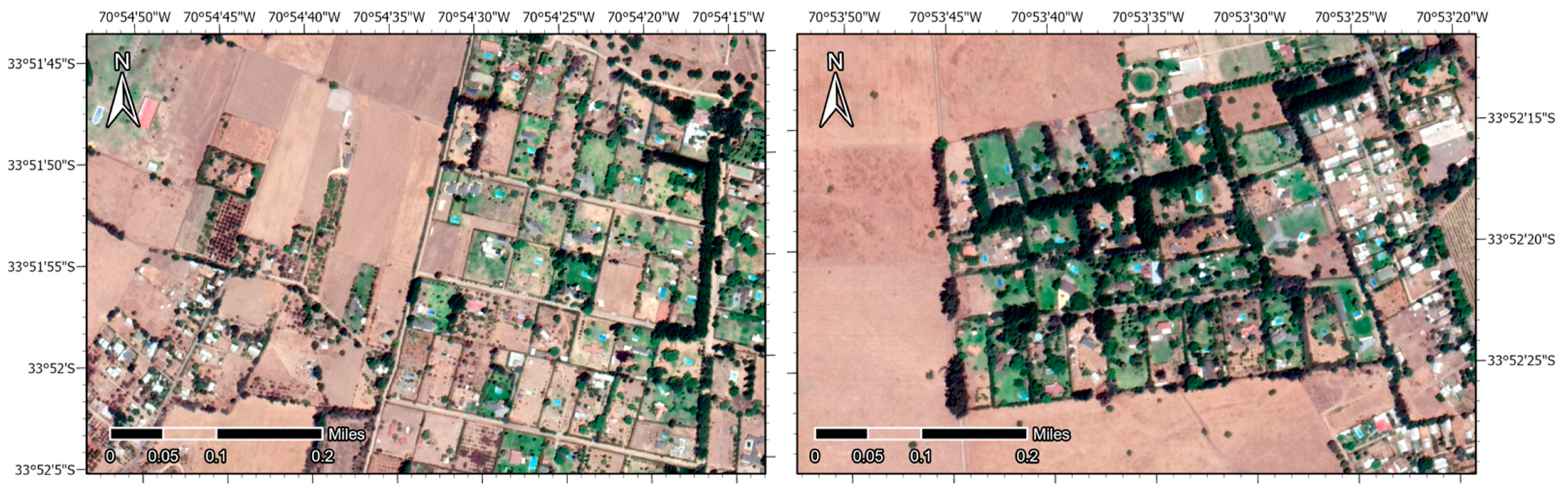
4.1. Land Use and Socio-Economic Changes of the Aculeo Watershed

4.1.1. The Agrarian Reform Triggering Land and Water Use Transformations

The economic, social, and ecologic relevance of the Aculeo Lagoon have already been described by many other authors (e.g., [16]). However, it is important for readers to know in detail that the watershed’s land use and water balance have gradually changed since the Agrarian Reform (in Spanish, Reforma Agraria, a process that expropriated and subdivided large pieces of land between 1962 and 1973, to pass them over to small-scale farmers) [21], but more intensively since the early 2010s, when an unprecedented combination among (1) intensified land-use changes that resulted in increased surface and groundwater withdrawals, and pumping directly from the lagoon; (2) anthropogenic diversions of affluents that historically contributed significant volumes of water to recharge this small lake–aquifer system (e.g., [20,22]); and (3) below-normal precipitation (in most years during the last decade after 2010), accelerated the lagoon’s natural drainage process (see details in [16], including a complete water balance).
To understand this drying process, it is important to recognize that the contemporary socio-economic history and land use of the watershed has been marked by the following two main processes: (1) Inquilinaje (1860–1968), in which the agricultural production (irrigated using flooding methods) was based on local man power, being the levels of productivity marked by the natural cycle of precipitation, plants, and animals [21]; and (2) Decomposition (1968–2012), which is the period starting with the previously mentioned Chilean Agrarian Reform [23,24], where the expropriation of land, together with the absence of technical and financial support for small-scale farmers (cultivating annual crops), resulted in locals selling their land, mostly for large-scale fruit plantations and summer homes [22,25]. The latter are commonly known as parcelas de agrado (in Spanish), which are land divisions regulated by the 3516 Decree Law (DL) that allows plots with a minimum size of 0.5 hectares. Most summer homes are owned by residents of Santiago, the nearby country’s capital [21,22]. This local growth resulted from increased touristic activity between 1985 and 2017, with an accelerated expansion of 1157 hectares of summer homes, of which 675 hectares (58%) occurred during the last decade (2009–2017) [22]. The economic value of rural properties during this period quadrupled due to a rising demand for land and its proximity to Santiago [22]. In this regard, when analyzing the evolution of land use between 1955 and 2019, it is clear that all the main valleys around the lagoon passed from annual crops (see for example 1955 and 1977 in Figure 2, or even as late as January of 2005 on Appendix A, when the watershed was still used mostly by local farmers for annual crops) to summer homes and fruit tree plantations (see years 2012 and 2019 in Figure 2, and Appendix B).
An important fact related to the massive establishment of summer homes is that each one historically had around half a hectare of lawn irrigated with sprinklers (a very inefficient irrigation method) and commonly a family size swimming pool (see example on Appendix B). The water used for lawn irrigation and swimming pool filling was obtained either directly from the lagoon or from pumping wells; in both cases, the water was obtained from the same lagoon–aquifer system (see details on [16]). In April of 2020 (two years after the disappearance of the lagoon), nearly 200,000 m2 of lawn were remotely sensed on the valleys surrounding the ex-body of water. However, it must be considered that due to a significant depletion of water tables in the area, most summer homes gradually stopped irrigating their green areas years before 2020, meaning that the total area covered by lawns was much bigger during the last decade (this can be easily confirmed using remote sensing products). The amount of water used every year for irrigating lawns at summer homes during the last decade is currently unknown; however, probably tens of millions of m3 of water (see for example [26,27]) were extracted from the lagoon–aquifer system every year, as most parcels were irrigated continuously all day long to maintain a green cover. Considering a hypothetical scenario with an irrigation requirement of 5 L per m2 per day between September and March (211 days) for a decade, the uptake is approximately between 3.3 and 5% of the total amount of water stored in the Aculeo Lagoon (assuming a total volume ranging between 40 and 60 million m3) [16]. In addition, many summer homes still have family size swimming pools (see Appendix B), which also contribute to annual water consumption (see for example [28,29]).

4.1.2. Evolution of Large-Scale Agriculture in the Watershed

Though water usage from summer homes was significant but gradually decreased after 2010, the opposite occurred for large-scale agriculture. The area of irrigated annual crops was censed at the Aculeo District in 2007, totalizing 529.4 hectares. Fruit trees were mostly dominated by orange, avocado, and cherry species, representing an area of 234.3 hectares [30]. In their WEAP modelling study (comparing the periods 1997–2006 and 2010–2018), Barría et al. [17] considered 143.06 hectares of fruit trees for the first period, and only 197.36 hectares of fruit trees for the second period. These underestimated areas were used by the authors to calibrate and run simulations for the Aculeo watershed. Most importantly, the annual water consumption considered by Barría et al. [17] for annual crops and fruit tree plantations were 11.5 and 1.72 million m3 (1997–2006), and 10.6 and 2.9 million m3 (2010–2018), respectively. These water consumption values are far from reality because the surface of traditional annual crops was gradually replaced by fruit tree plantations or summer homes (or simply abandoned), reaching insignificant values within the last decade. This rapid land use change was accelerated when local farmers no longer had access to water once the lagoon–aquifer system (i.e., lagoon and shallow wells) depleted to very low levels. Barría et al. [17] stated that annual crops decreased by just over 30%, which is obviously not the case. These differences represent an additional missing demand for the water balance performed for the watershed, since it is well known that fruit trees are the type of agricultural land use with the highest water consumption (even with dripping irrigation systems), as trees need to obtain enough water to produce healthy fruits according to international trading standards (e.g., [31]).
Since there was an abundance of water in the area before 2010, flooding methods were traditionally used to irrigate annual crops, which might not be the most water efficient option for agriculture, but research has shown that most of the flooded water can be percolated (recycled) back to the local aquifer (e.g., [32,33,34,35,36]). This hypothesis is most likely the truth in many valleys of Mediterranean Chile, where shallow subsurface water fluxes from irrigation channels, ponds, crops, and plantations can represent an important contribution of return flow for surface and groundwater systems. This is a clear explanation for why most of the valley being occupied with annual crops did not significantly affect the lagoon–aquifer interaction and water levels before 2010. Annual crops were irrigated with water withdrawn directly from the lagoon–aquifer system, through shallow wells or directly from the lagoon (as previously mentioned), and a large pumping station (more than a century ago) located in the southeastern boundary of the lagoon. Later on, a new pumping station was established on the southern border of the water body around 2010, exclusively to irrigate newly established fruit tree plantations.
The encountered differences on agricultural land use can be easily propagated to the calibration of any water balance model, e.g., through the amount of water needed by annual crops and fruit trees. In fact, the correct definition of those can play a significant role when simulating the water balance of Aculeo or any other small watershed with similar hydrology. For example, considering eight months of annual irrigation on fruit tree plantations, the 2.9 million m3 used by Barría et al. [17] is a value difficult to fit in the real world, keeping in mind that the demands of the sector are so high that all affluents were deviated, a series of deep wells that pump water 24/7 were drilled, and the previously mentioned second powerful pumping station was built to extract water directly from the lagoon. It is also important to add that the most recent National Census (not published yet) will provide updated conditions of irrigated land and agricultural uses in the Aculeo District (see some updated information in [30]). Preliminary results of the National Census will be available within the next few months, and final results in the second half of 2022. The updated land use information for Aculeo must be included in any future water management strategy aimed to recover the lake–aquifer interaction for the watershed.
In short, since the Agrarian Reform (and more intensively after 2010), an unsustainable socio-economic transformation of land use for summer homes and large-scale agriculture in the Aculeo valley has been dominant until the present days, agreeing with the conclusions by several authors [13,14,15,16,22], and disagreeing with Barría et al. [17]. The combination of poor water resources management and land use planning led by governmental authorities placed Aculeo in an extreme hydrologic condition that ended up affecting the capacity of this small watershed to cope with the current drought (or megadrought), as it did in the past (see next Section for details). In fact, locals and most scientists involved with this small watershed agree that both unsustainable water management and inappropriate land use planning are the primary factors that impacted the ecosystem services historically provided by the lagoon [14,15,16]. The impacted ecosystem services were identified as those mainly related to water regulation and water supply (see details in [13]), and they caused a disruption of the lagoon–aquifer interaction with steady reductions in the water levels historically observed on the watershed, as shown in other sections further down.

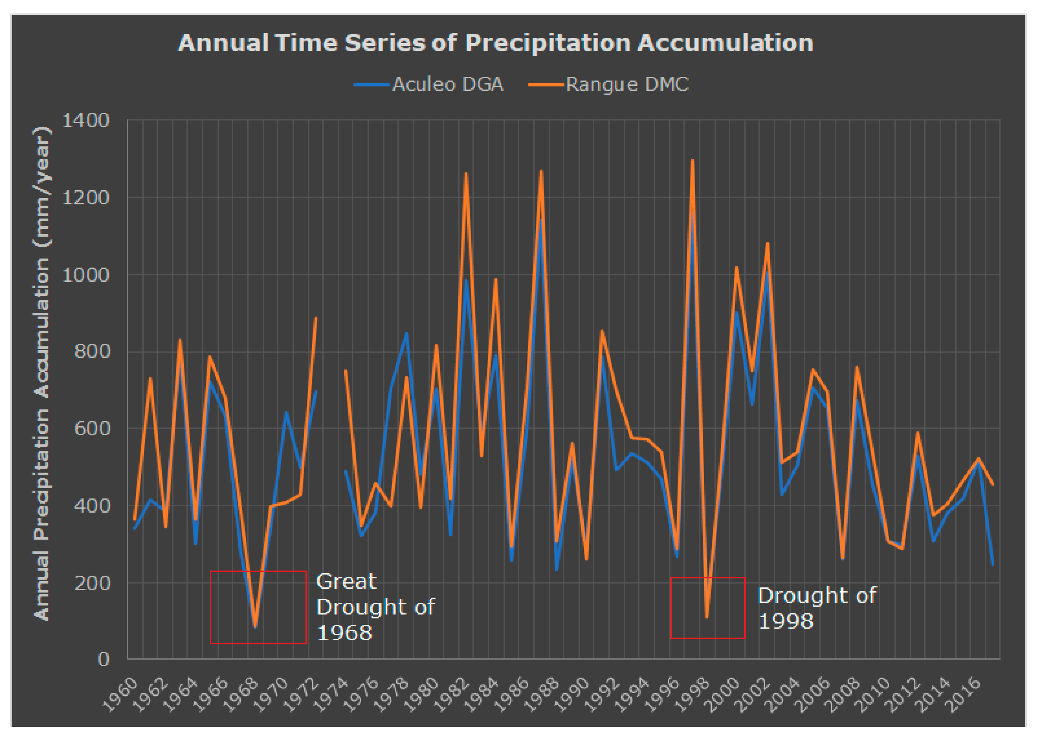
4.2. Regional Climate Variability in the Southern Westerly Wind Belt and Paleoclimatology of Aculeo

Previous research reconstructed Austral summer (DJF) temperatures, revealing sub-decadal- to centennial-scale climate variability for central Chile (30–40° S) back to 850 A.D. [37]. The interannual, interdecadal, and multi-decadal variability of annual rainfall, on the other hand, is characterized by a well-defined annual cycle, with a peak of precipitation accumulation in the Austral winter and much lower values during the rest of the year [38]. This strong seasonality of precipitation results from the winter retreat of the South-East Pacific Anticyclone (SEPA), which allows a low-level Southern Westerly Wind Belt (SWWB) carrying frontal systems into central Chile. Additionally, the climate (rainfall) variability over this region is controlled at different timescales by ocean–atmosphere teleconnections linked to warming in the Pacific and Atlantic oceans. For instance, the most important warming interactions are dominated by El Niño Southern Oscillation (ENSO) (see Figure 3a), the Pacific Decadal Oscillation (PDO), the Antarctic Oscillation (AO), the Atlantic Multidecadal Oscillation (AMO), and the Madden and Julian Oscillation (MJO), among others [38,39,40,41,42,43,44].
Being a small (206-km2) watershed with a surface body of water surrounded mostly by mountain ranges with elevations that can reach up to about 1300 m.a.s.l. [45], Aculeo lies at the northern boundary of the Southern Westerly Wind Belt (SWWB) and, therefore, it is dominated by a steep precipitation gradient [9]. Previous palaeoclimatological investigations indicate an arid early-to-mid Holocene period (about 9500–5700 cal yr B.P.) with an increase in annual rainfall after 5700 cal yr B.P., increasing even more (to modern conditions) to around 3200 cal yr B.P. [9,10,11,12]. Scientific evidence shows that this body of water has not naturally disappeared for thousands of years [9,10] (a fact confirmed by one of the authors from the former study, as they always found lake-related diatoms in the sediment core extracted from the bottom of the lagoon), making it hard to believe that a decade of below-normal precipitation (including a few wet years, as detailed further down) under modern humid conditions would be the main variable leading to the complete disappearance of the lagoon, as concluded by Barría et al. [17]. Moreover, as explained in other sections, the Aculeo watershed did not actually experience a megadrought during the analyzed time period.

4.3. Understanding Precipitation Recycling Effects in Aculeo

There is enough evidence to suggest that the strong precipitation gradient produced by SWWB generates a high spatio-temporal variability of annual accumulation over the Aculeo watershed. This gradient generally translates into more annual precipitation accumulation over rain gauges located inside the watershed that encloses the lagoon, compared to those located to the east (Pintué River watershed), west, and north of Aculeo (see Figure 1). Moreover, comparative analysis of two rain gauges, Aculeo DGA (used by Barría et al. [17] as the main input information to build their WEAP model, located in the easterly neighboring Pintué watershed and not “within the Aculeo Lake catchment”, as stated in their publication) and Angostura DGA, revealed important differences on annual precipitation accumulation compared to the Rangue DMC rain gauge, the only rain gauge located within the Aculeo watershed, with yearly data available between 1913 to date, being a government station between 1962 and 2016 (a period of which daily records are available). As mentioned by Barría et al. [17], the “Laguna de Aculeo” DGA station has rainfall information from 1960 to date, but the authors only considered information from 1970 for some of their analyses, excluding the important great drought of 1968–1969.
It is also important to add that there are several other additional rain gauges managed by locals and government institutions inside the neighboring Pintué watershed (see Figure 1), but neither of those were considered by Barría et al. [17]. The fact that some of these records are not collected by a government agency does not mean that they cannot be used for research purposes. In fact, there are countless studies that have conducted remarkable investigations based on personal or family owned rain gauges (e.g., [46,47,48,49,50,51]). Therefore, considering government and/or personal rain gauges closer to the lagoon is very important for the development of modeling strategies because of the strong precipitation recycling effects observed in water bodies along Chile [52], which can be enhanced during ENSO warmings. For example, the differences between Rangue DMC and Aculeo DGA (used by Barría et al. [17]) reached up to more than 200 mm in the strong 1992 ENSO and more than 100 mm in the 1997 ENSO (Figure 3b). The annual accumulation gradient is much more noticeable when comparing Rangue DMC and Angostura DGA rain gauges (see Figure 1 for location references), where the differences in annual accumulation reached up to more than 700 mm in the 1997 ENSO (Figure 3b). Moreover, from 58 years of available data for this comparison (1960–2018), there is an additional total rainfall depth of 3155.1 mm documented at the Rangue DMC station (compared to the Aculeo DGA station used by Barría et al. [17]), which represents a total catchment volume of about 11–16 times the total volume of water stored by the lagoon [16]. In fact, the additional rainfall captured at the Aculeo watershed over the 1960–2018 period represents, on average, between 19 to 28% of the annual volume of water stored in the lagoon (see details in [16]). These striking differences have to do with the location of rain gauges within the Maipo–Aculeo domain. For example, the Angostura DGA rain gauge is located north of the northern Aculeo mountain range boundary. Therefore, it could be largely affected by orographic blocking of the SWWB. However, it is likely that strong precipitation recycling effects [53,54,55,56,57,58] were enhanced over Aculeo when the lagoon was an active body of water. This recycling pattern observed at the Aculeo watershed has been previously studied along Chile by Pizarro et al. [52], who concluded that gauges located closer to water bodies register storms with much higher rainfall intensities compared to rain gauges located away from them. This contribution of local evapotranspiration to precipitation depends on the characteristics of the land surface and climate [57] and it can produce more annual precipitation accumulation compared to surrounding areas, as clearly shown for the case of the Aculeo watershed. For example, in the Amazon basin, the contribution of evapotranspiration to local precipitation (recycling fraction) has been estimated to range from 25 to 35% [54,55], while studies carried out in China have stated that the recycling fraction depends on the seasonal and inter-annual climatic variations. In fact, a range of variation between 14.1 and 22.8% was found in northern China for the same month (May) under different hydrologic conditions (wet versus dry years, respectively) [59]. In Australia, contributions from precipitation recycling varied from 11% in winter up to 21% in summer [58]. All these studies (and many more) have revealed the relevance of precipitation recycling effects on the precipitation–evapotranspiration patterns of local and continental landscapes, together with the presence of water bodies, which help enhancing this physical interaction between hydrological fluxes. Therefore, any estimation of the water balance on the Aculeo watershed should consider the relevance of these spatio-temporal patterns in the amount of water stored in the watershed (see next section for details). Since Barría et al. [17] fed their WEAP model using only one rain gauge located in the neighboring Pintué watershed, the authors’ analysis should be re-evaluated using local rainfall records, as presented in this study.

4.4. Climate Records Used for Water Balance Simulations in Aculeo

As seen in the previous section, the appropriate selection of precipitation records is a key decision for modeling strategies because this flux is more important than temperature, both being dominant fluxes needed to perform reliable hydrological modelling strategies. For example, rainfall in this area normally occurs during winter months, when most plant species are dormant, and irrigation (agriculture and lawns) is practically absent. In this regard, an analysis of the temporal dynamics of vegetation evapotranspiration and vigor revealed a periodic pattern in both managed lands (which includes summer homes, annual crops, and fruit tree plantations) and native lands (which includes the surrounding native vegetation) (see Figure 3c,d). From this analysis, the highest evaporation and evapotranspiration rates in managed lands were found during summer months, which is the season when most irrigation occurs. This evaluation suggests that managed lands produce higher evapotranspiration rates, but at the same time, there is no evidence of a significant change or trend on evapotranspiration rates over time (at least not before the lagoon disappeared in 2018), as suggested by Barría et al. [17], who assumed that precipitation decreases were produced by evapotranspiration rates’ enhancement because of a significant increase in the annual daily average temperature. However, evapotranspiration rates are seasonal, being negligible during winter months and higher during summer seasons. During the dry season (Austral summer), evapotranspiration rates are mostly a function of the water used for the irrigation that is applied to crops, fruit trees, lawns, or swimming pools, primarily obtained from the local lagoon–aquifer system (either directly from the lagoon or through pumping wells/stations), and/or from the rivers and creeks that used to flow most of the hydrologic year. In other words, an increase (or decrease) in annual rainfall accumulation (during winter) would not necessarily generate a direct increase (or decrease) in evapotranspiration rates observed in the Aculeo watershed during growing seasons (as suggested by Barría et al. [17]), since both fluxes have their peaks at different seasons within a hydrologic year.
To test how the hydrologic partition of precipitation and evapotranspiration occurs in the Aculeo watershed, two of the most popular hydrological drought indices (SPI and SPEI) (see details in [60,61,62,63,64,65]) were calculated using Laguna de Aculeo DGA rainfall and temperature records (Figure 3e). The long-term pattern analysis (1990–2020) only revealed severe drought conditions (6 months) in the December of 1998 (strong La Niña conditions) and moderate drought conditions (also 6 months) in the June of 2015, despite the presence of a strong ENSO, with these two being the most extreme events. During recent years (2015–2019), the drought indexes fluctuated within the range of mild-to-moderate drought conditions (probably due to the higher rainfall accumulation observed in 2016), meaning that streams, reservoirs, or water tables on wells could be lower, but no significant impacts on natural hydrologic systems should be expected. The original classification of each drought index was used to determine the hydrologic partition based on rainfall and evapotranspiration records. This finding revealed that higher evapotranspiration rates suggested by Barría et al. [17] were not the primary driver of the natural water balance of the Aculeo watershed and its lagoon, at least not anywhere near the drying extent observed in 2018.
Barría et al. [17] also indicated that, due to interannual variability, annual rainfall only ranges between 435 and 850 mm per year. However, the observed annual precipitation accumulation variability for Aculeo DGA is 84.5 (drought of 1968–1969), and 1160 mm per year during the 1997 ENSO year. Furthermore, according to Rangue DMC records (1913–2019), the annual rainfall variability in the Aculeo Lagoon watershed is stationary (as revealed in several tests performed in this analysis), ranging between 77 mm recorded during the drought of 1924 (the great drought of 1968 recorded 88.5 mm) and 1309 mm (wet year of 1926). The historic mean annual precipitation accumulation for these records is 572.1 mm (603.9 mm per year for the 1960–2009 period, and 418.84 mm per year for the 2010–2018 period). Barría et al. [17] also indicated that local effects of the central Chile’s megadrought are noticeable because the annual average rainfall from Aculeo DGA station between 1960 and 2009 was 544 mm and then dropped in the 2010–2018 period to 355 mm (deficit of approximately 38%.) Using this comparison, the authors argued that a reduction in the multi-year mean is due, in part, to the absence of very wet years that punctuated previous decades. This statement is not correct because a comparison of the long-term average for two different periods is not enough to detect long-term changes on precipitation accumulation. In this regard, the calculation of long-term precipitation averages or accumulation for different moving windows (i.e., 5, 10, 15, 30 years, etc.) offers a much better way to visualize and detect long-term patterns of dry and wet periods, and it can also better reveal how low-frequency signals control the long-term hydrological memory of the watersheds (see [44]). For instance, our analysis of long-term annual precipitation accumulation (using Rangue DMC records) revealed that below-normal conditions were prevalent between 1945 and 1983 on 10- and 15-year accumulated moving windows, respectively. However, on the 30-year multi-decadal signal, dry conditions were prevalent between 1956 and 1986 (see Figure 4). After this period, there was a marked wet cycle (above-normal conditions) that peaked before 2010, and since then there has been a negative trend that became “below-normal” in 2017 (30-year), 2015 (15-year), 2012 (10-year), and 2011 (5-year). From this analysis, it is important to add that the 30-year moving window shown in Figure 4 represents a clear example of why the concept of “megadrought” is not the primary factor for the disappearance of the lagoon. For example, accumulated dry conditions were more intense in previous decades over the Aculeo watershed (i.e., the great drought of 1968–1969), and the lagoon did not disappear or significantly decrease its levels (personal communication from Alfonso Ortiz, a local 74-year-old farmer born in the watershed). In short, comparing two short-term rainfall periods (1960–2009 and 2010–2018) to drive conclusions, ignoring decades of previous data (as performed by Barría et al. [17]) does not reflect reality and only represents part of the past climate in the area (see Section 4.5 for details).

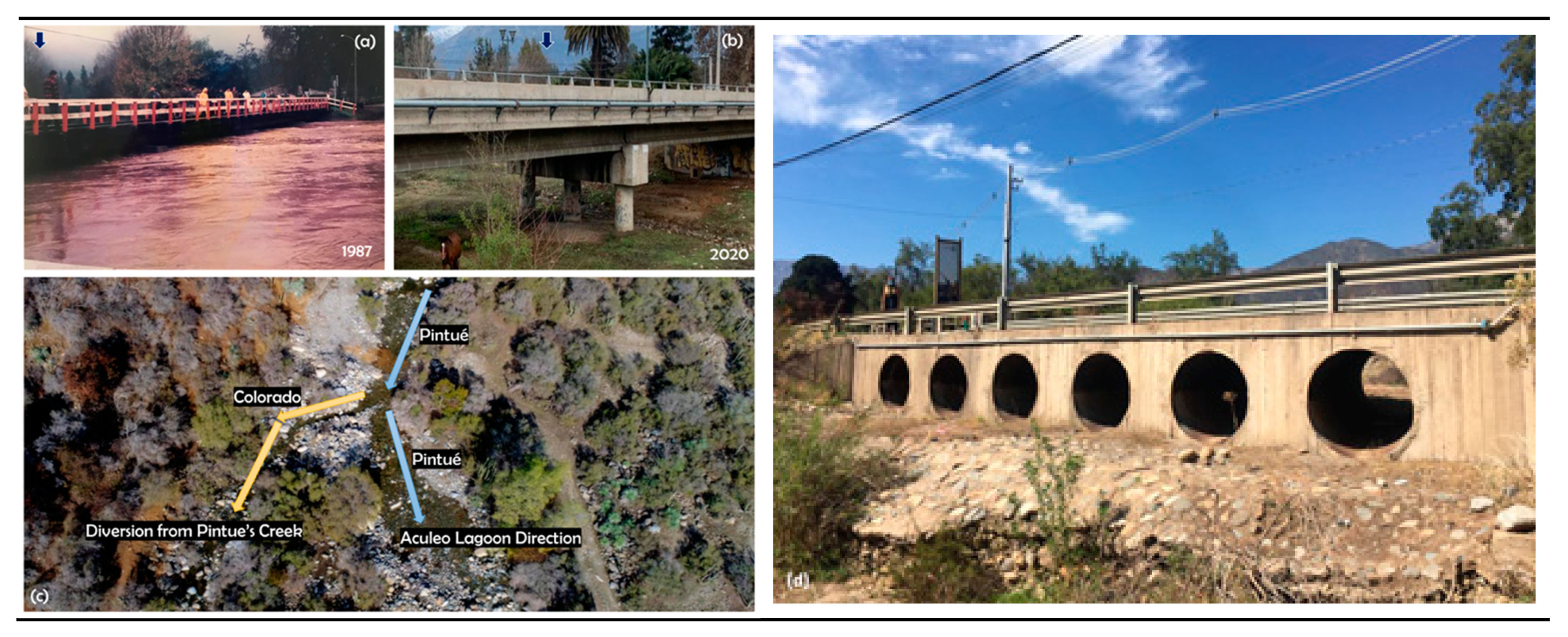
4.5. Anthropogenic Diversions and the Lagoon’s Water Balance

As previously mentioned, the available literature provides diverse studies that have been carried out in the Aculeo watershed and its lagoon during the last few decades. However, the anthropogenic modifications applied to the watershed and its water balance have only been a topic of discussion in recent studies [13,14,15,16,22]. All these studies agree that strong land use transformations, increased lake and groundwater consumption, and the diversion of surface tributaries are currently the most important environmental and hydrological problems in the Aculeo watershed (see Section 4.1 for details). These well-recognized anthropogenic modifications occurred at the end of a 30-year wet cycle (see Figure 4 and Section 4.4) that started around 1998 and peaked in 2009. This most recent 30-year wet cycle started decreasing since then and reached normal-like conditions during 2017–2018. However, the rate of this latter decreasing wet cycle trend (2019–2020) is about three times higher than the rate of the 30-year dry cycle decreasing trend observed between 1954 and 1975. Interestingly enough, the previous dry cycle lasted for longer time (22 years versus 9 years in Barría et al.’s [17] analysis) and the lagoon barely decreased its levels nor disappeared, even during the great drought of 1968–1969, as it did in 2018, even though the valley was completely covered by annual crops back then (see Figure 2 and Appendix A).
Regarding the lagoon’s water balance, it is important to indicate that up to 2010, the lagoon used to be fed by many important tributaries such as Pintué, Las Cabras, Aculeo, and Huiticalán tributaries, among others (see Figure 1). All these inflows (but mainly Pintué and Las Cabras) represented a significant surface water contribution to the lagoon–aquifer system, as they used to run during most of the winter and spring every year. As indicated by many locals (e.g., Alfonso Ortiz, personal communication), Pintué River used to run all year round, with impressive volumes during winters and springs and even during summers, and Las Cabras could even run up to summer months (see Appendix C for details), and not exclusively “during storm events”, as stated by Barría et al. [17]. These rivers are currently dry (except for Pintué, which has had a permanent but insignificant flow since 2010) [66], because they were completely deviated upstream for agricultural irrigation purposes (mostly fruit tree plantations), a process that started in the mid-1990s and became much more unsustainable around 2010 (see Figure 5 for details).
Instantaneous streamflow records of Pintué River were documented by DGA between 2003 and 2010 (Figure 5a). Our analysis of recession curves revealed clear patterns of upstream deviations at Pintué River that ended up affecting the environmental flows of this important affluent to the lagoon. For example, there was a streamflow recession that lasted for more than 200 days in 2003, having antecedent conditions of about 62 mm of rainfall accumulation (2 weeks before the event was registered at the closest Laguna de Aculeo DGA station), and peak flows between 1.5 and 2 m3/s (see Figure 5b). These natural hydrologic recession conditions can be also observed in 2004 (Figure 5c), with much lower antecedent precipitation accumulation. Between 2005 and 2006 (Figure 5d,e), on the other hand, higher 2-week antecedent rainfall accumulation (~168 and 212 mm, respectively) generated higher peak flows (~9 and 11 m3/s, respectively), but much shorter streamflow recessions (96 and 118 days, respectively), most likely due to partial streamflow deviations that started around this period. Based on this hydrological evidence, the anthropogenic modifications carried out at Pintué River reached a peak between 2007 and 2010, a period in which it is very clear that similar precipitation accumulation generated similar peak flows with much shorter recessions (see Figure 5f–h). The most critical situation started in 2010 (Figure 5f), when, despite an antecedent rainfall accumulation of ~144 mm in the watershed (2-to-5 times higher than that that occurred in 2003 and 2004), there was no streamflow response, and it can be inferred from the hydrograph records that most of the water was deviated upstream, as there was no characteristic recession curve (it is important to mention that Barría et al. [17] assumed a significant river flow contribution from Pintué in their model until as late as 2018, which is not the case, as previously discussed). The negative variation of water volumes in the main tributaries translated into a decrease in the water stored in the Aculeo watershed because of a gradual temporal loss of the interaction between surface and groundwater systems (due to upstream diversions, together with the increasing pumping volumes previously discussed). The environmental flows of Pintué River were so low that a levee was built in 2005 at the lagoon’s natural surface drainage (at the Santa Marta stream, which used to drain the lagoon’s excess water during wet years). The levee was built by a non-profit named CAVA (In Spanish, Corporación de Adelanto del Valle de Aculeo, a local organization that seeks to recover the lagoon’s water levels) to direct the Pintué’s surface water flows into the lagoon.
An impulse response function (IRF) distributed over twenty monthly time steps showed that Pintué flows were strongly related to the lagoon’s water levels, agreeing with Meneses [66], who found that it created a subsurface hydrological barrier that prevented the lagoon from underground draining. Additionally, monthly records revealed that Pintué flows can significantly lead the lagoon’s water levels for up to two months (see Figure 6, left). For example, a peak streamflow event generated from intense rainfall storms can provide instantaneous recharge to the lagoon (see lag zero at IRF on Figure 6, left), but there is also a slower groundwater recharge component that is significant and clear from 1 to 4 months (see example for significant two-month correlation in Figure 6, right). This is additional strong evidence of the high relevance of surface and groundwater sources for a sustainable long-term water balance of the Aculeo Lagoon.
The above evaluation provides sufficient proof of streamflow deviations upstream of the Pintué River (added that there is substantial evidence to say that Las Cabras Creek was completely diverted in the 1990s, as shown in Appendix D), and it is another important component that invalidates the analysis conducted by Barría et al. [17], as they should have considered it for their WEAP model’s implementation and the water balance estimated for the Aculeo watershed. It is also important to mention that Barría et al. [17] did not give much relevance to the groundwater factor in their model (herein proven to be extremely important), as they assumed it was negligible based on a report developed by a consulting firm [67].

4.6. A Long-Term Natural Relationship between Precipitation and Water Levels

As previously mentioned, the lagoon’s water levels were documented at the following two locations: (1) Laguna de Aculeo en Los Castaños (DGA station, used by Barría et al. [17] for their analysis), located in the south-east border of the lagoon, in which monthly values between 2006 and part of 2013 were recorded using an electronic datalogger. However, QA/QC analysis of records indicate a malfunction of the device during part of 2006 and 2007, and most of 2011 (see Appendix E), leaving no choice but to discard such information in our study; and (2) Administrative staff at Pintué Campground (located at the north-east border of the lagoon) measured the distance between their duck and the lagoon levels almost every Monday from 1999 until the duck went dry in 2017. Since a strict correlation existed between both measuring locations before the 2011 malfunction of the former station (see Appendix E for details), the latter personal station was considered to evaluate the natural long-term relationship between annual precipitation accumulation documented at Rangue (DMC) and Aculeo (DGA) rain gauges, and the lagoon’s water levels. Considering the whole period with the available data (i.e., 1999 through 2017), no apparent correlation exists between the two hydrological variables (see distribution and low R values in Figure 7a,b). However, knowing that most land use changes, river deviations, and increases in water consumption occurred around 2010, the previously mentioned long-term relationship between annual precipitation accumulation and lagoon water levels was strictly linear before such period (with R values of 0.69 and 0.86 for minimum and average water levels, respectively), i.e., the more it rained in a single year, the higher the lagoon’s water levels became, and vice versa (Figure 7c,d), because of sustained seasonal surface and groundwater recharge and low water consumption in general. This relationship supports one of the hypotheses by Barría et al. [17], who suggested a strong relationship between precipitation and the lagoon’s water levels. However, it is clear that after 2010 such correlation was strongly impacted by anthropic factors because annual rainfall was no longer a variable affecting the lagoon’s water levels, and no matter how much it rained in a single year, the lagoon (aquifer) levels kept decreasing until disappearing (see negative R values and vertical distribution in Figure 7e,f). In other words, if a persistent climatic drought was the main responsible for the lagoon’s depletion (as concluded by Barría et al. [17]), the relationship between annual precipitation and lagoon’s water levels would have still been linear after 2010, since there were more than two wet years documented at both Rangue DMC and Laguna de Aculeo DGA rain gauges within the 2010–2018 period (see Appendix F). This presents undisputable evidence that the accelerated and excessive water consumption applied to the watershed played a main role in the lagoon’s disappearance, making it impossible for this small watershed to maintain its long-term natural water balance, which was historically dominated by seasonal winter precipitation and several sources of water recharge.

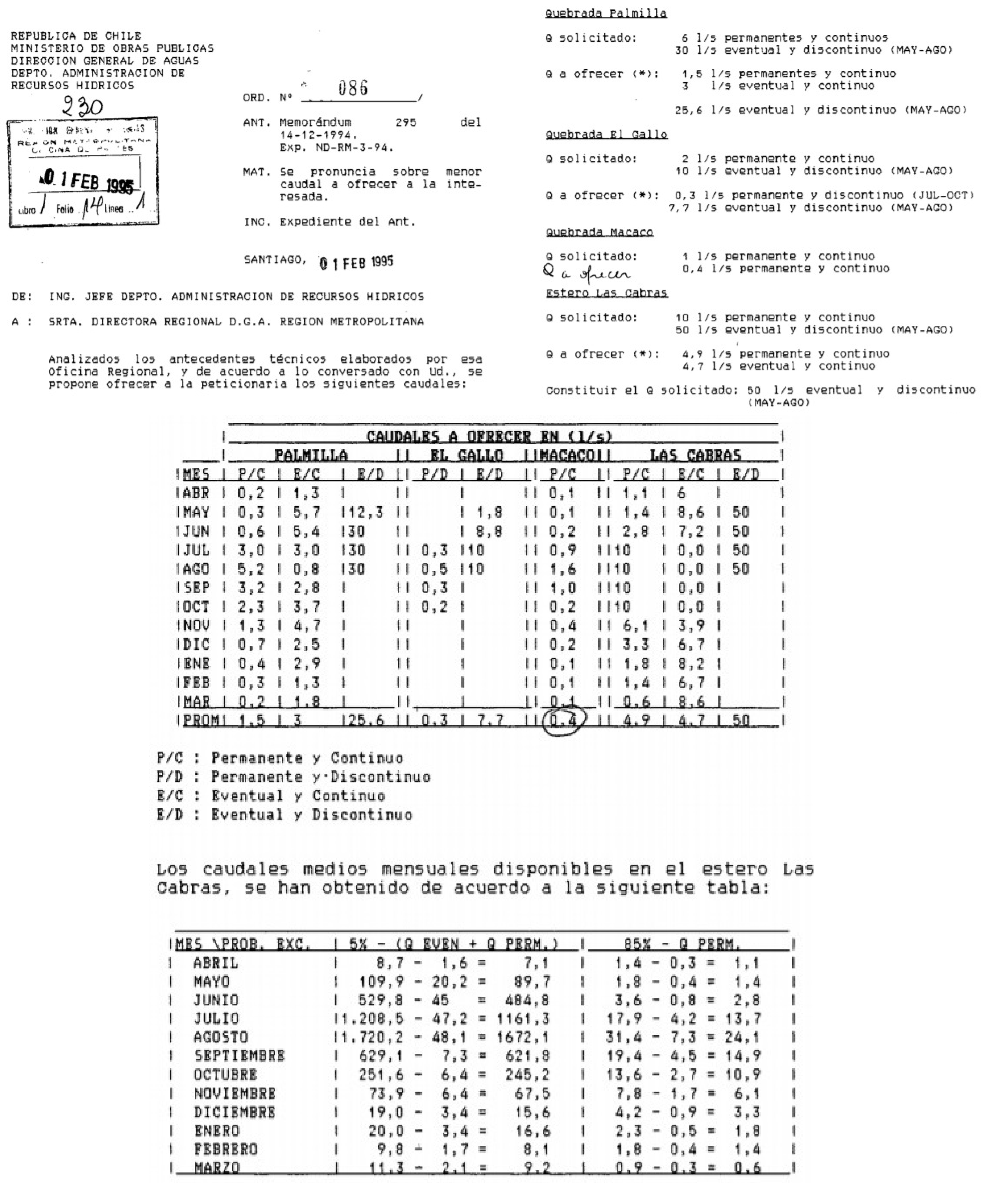
4.7. Increased Water Demands and Allocation of Water Rights

Together with the reported deviations of surface flows at Pintué and Las Cabras tributaries, and the consequent reduction in the lagoon’s static water levels (and its surface area) (Figure 3f), the legal water demands and water rights allocation also dramatically increased over time (Figure 3g), resulting in the growing pumping of groundwater resources (illegal extractions were not quantified in this study, though several authors agree that it represents a growing problem in the area [13,14,15,16,22]). Before 2000, there were only 144 L/s of groundwater rights allocated in the Aculeo watershed (not including the Pintué watershed), a value that was doubled between 2004 and 2008 (145.8 L/s more). During the late 2014–2020 period, an additional 90.9 L/s on water rights were allocated in the watershed, with about 50% of those rights occurring after the complete disappearance of the lagoon in 2018 (Figure 3g). Currently, the total DGA’s official water rights allocated in the Aculeo watershed are around 381 L/s (Figure 9), i.e., more than 12 million m3 per year (which is between 20 and 30% of the lagoon’s total volume, considering perpetuity and continuity in groundwater extraction), with most of them destined to large-scale agriculture. Again, Barría et al. [17] indicated that the demands associated with fruit tree plantations are just below three million m3/year, a value that is very far from reality.
Moreover, the previously discussed lawn irrigation and swimming pool fillings in summer homes (most of them having their own wells) makes things even more complicated, as current water laws in Chile allow the following three very special cases for groundwater use rights: (1) drink and domestic uses; (2) waters found in mining activities; and (3) lit waters in the exercise of geothermal energy concessions [68]. According to (1) (Article 56, Incise 1° of Chile’s Water Code), anyone can drill wells in their own soil for drinking and domestic uses without permission. The Chilean regulation specifies that the notion of “drinking and domestic use” corresponds to the water that a person or family withdraws from a well for the purpose of drinking, personal hygiene, and growing fruit and vegetable products indispensable for their subsistence, without economic or commercial purposes [68]. The problem with this exceptional case resides in the fact that most summer homeowners in Chile consider that water used to irrigate lawns or filling up swimming pools is part of their domestic use. This led to increased drilling of an unknown number of shallow and deep wells within the Aculeo watershed. For instance, the National Census of 2017 [30,69] reported 1602 houses in the Aculeo district (~52% of residence in Aculeo). By the time of the census, Aculeo residents indicated that their main source of water was from the public network (a low coverage of only 59.7%, though local public water supply also comes from the same aquifer). On the other hand, 36.3% of residents indicated that their main water source was from pumping wells, and only 3.3% had alternative water sources such as distribution by water trucks or direct consumption from creeks or springs up in the mountains. Only considering people using water from non-registered pumping wells, there are about 304 pumping wells reported by the National Census in the Aculeo district (Figure 8). These wells are additional to those legally registered by DGA (only 34 active pumping wells out of 54 with water rights within the Aculeo watershed) (see Figure 8). Additionally, by the time of the census, nobody was in most of the summer homes (as the majority of owners live in Santiago); therefore, a lot of information in regard to private wells was lost. Therefore, there is no clue about historic extractions and how water is currently being used in the watershed, or even in the whole country. Only a few monthly time series of water levels from DGA and local shallow monitoring wells (measured in 2017) are available for the whole watershed (see Figure 9). The long-term records of groundwater levels clearly show a regional aquifer depletion, which is evident within the watershed but also from wells located outside the area, being also under tremendous extraction pressure (e.g., Asentamiento Las Vertientes monitoring well) (Figure 9).
The difference between the number of wells legally registered at DGA and those reported by the National Census of 2017 is an additional source of discharged water volume that should have been considered by Barría et al. [17], since this component is most likely a very significant flux that needs to be added to any modelling strategy implemented for Aculeo, and for any watershed. The uncertainty added from these extractions is also related to the fact that most people are not aware that the legal right of exceptional uses only applies if any other access to water to satisfy their basic needs such as the coverage of drinking water or sanitation, is not viable (both in urban and rural areas), with a lack of inspection from DGA being a commonly known problem in Chile. At the same time (as known by locals), the two pumping stations discussed in previous sections, hundreds of summer homes, and several condominium-type gated communities pumped water directly from the lagoon, a process that continued even while the lagoon was retreating (this can be easily verified with remote sensing tools).

4.8. Regional Aquifers and Groundwater Storage Volumes

The clearly unsustainable water management and inappropriate land use planning (both led by the government) applied to Aculeo, as shown in the previous sections, was also the result of poor identification and management of regional aquifers and their groundwater levels (see Figure 8 and Figure 9), and storage volumes. For example, El Monte Nuevo aquifer (206.1 Km2), which is the most recent common sector of groundwater use for Aculeo, was recently identified [70], though the identification of aquifers in the Metropolitan Region of Chile started back in 2002 to understand the hydrogeology of large-scale groundwater resources [71]. The Santiago Sur aquifer (1896 Km2) was the first identified hydrogeologic system, which included Aculeo within its domain (see Table 1). The maximum sustainable groundwater extraction for this aquifer was estimated at 630 million m3/year [72]. However, an updated hydrogeologic identification was carried out in 2007, and the Santiago Sur aquifer was divided into four sub-aquifers, with Aculeo being included in the El Monte aquifer (664.1 km2), the main regional system with an estimated total sustainable groundwater volume extraction of about 98 million m3/year [73]. Though this aquifer was declared under restriction of additional groundwater extractions in 2008 [74], provisional water rights of almost 13 million m3/year were also included together with this legal resolution, as shown in Table 1. In 2010, the provisional water rights at the El Monte aquifer were increased to more than 24 million m3/year [75], a legal resolution being revoked in 2011, when the volume of provisional groundwater rights was decreased to 14 million m3/year [76].
The most recent identification of the El Monte Nuevo regional aquifer was associated with a sustainable groundwater volume extraction of 88.5 million m3/year [70], which is only 9% less volume compared to the original El Monte aquifer. Nevertheless, the capture area of this aquifer is about three times larger than the El Monte Nuevo regional aquifer. Even though storage volumes were largely increased for this new regional sub-aquifer, the total allocated demand was set at over 246 million m3/year [70], which is more than three times the estimated volume stored underground. Therefore, when the lagoon disappeared in 2018, there was a serious water unbalance in the regional aquifer that was of government knowledge. The total allocated demand was adjusted in 2018 using a sustainability ratio (demands/availability) of the neighboring Buin aquifer, suggesting that the demand for the El Monte Nuevo aquifer could be up to 2.8 times the availability [77].
With the above discussion, new provisional groundwater rights of 1.3 million m3/year were allocated for the El Monte Nuevo aquifer. With these new additions, the maximum allowable groundwater extractions were established at almost 248 million m3/year in 2018 [77]. This most recent legal resolution also established that Aculeo’s local aquifer is a new restriction area for additional groundwater extractions. This legal restriction was only applied in June of 2018, after the complete disappearance of the lagoon, revealing that the Chilean Government never anticipated the disaster due to a lack of appropriate technical studies and specific knowledge about the regional hydrogeology present in the area. Despite the above, new groundwater rights were allocated in 2020, as mentioned in other sections of this document. This analysis suggests that another important reason leading to the disappearance of Aculeo was a lack of regional hydrogeological knowledge, together with the previously mentioned inappropriate water resources management and land use planning conducted by national and regional government decision makers.

5. Conclusions and Recommendations

Though land use on the watershed was dominated by annual crops until as late as 2005 (according to remote sensing information), such practice did not affect the hydrologic balance of the Aculeo Lagoon–aquifer system much, as they were irrigated with flooding methods, which might be an inefficient practice, but it is well known to recycle most of the water back to the aquifer through percolation. However, annual crops literally disappeared from the area, being gradually (but not entirely) replaced by summer homes, characterized by their highly demanding lawn surfaces and swimming pools, though green areas in the watershed decreased as a result of water scarcity (several years of below-normal rainfall). Despite the above, the abrupt establishment of fruit tree plantations around 2010 was the most significant land use change, being not only the most water-demanding agricultural practice, but also, they are irrigated through dripping systems, eliminating the historical aquifer recharge effect that annual crops used to have. Once fruit tree plantations were established, Pintué River (the aquifer’s main tributary) was almost completely deviated (as shown in our recessive flow analysis), together with other important tributaries such as Las Cabras (completely deviated in the mid-1990s), the drilling of an unknown number of deep wells, and a powerful second pumping station being installed to uptake water directly from the lagoon, all to satisfy the tremendous demands from large-scale agriculture. Indeed, the strict correlation that existed between annual precipitation and aquifer (i.e., lagoon) levels was completely broken after the establishment of fruit tree plantations; if below-normal precipitation was the main cause for the disappearance of the lagoon, such linearity would have continued after 2010. Similarly, our analysis indicates that the groundwater portion is a significant variable in the hydrologic cycle of the watershed, a component that must always be considered in any model developed for the area.
Paleo climatologically speaking, our literature review revealed that the lagoon has not dried out for thousands of years, making it hard to believe that a decade of below-normal precipitation (including a few wet years) in modern climate conditions would be the main responsible for the disappearance of this natural body of water.
The increase in legal water consumption in the watershed and its aquifer during the last decade or more has been outrageous, suggesting that a big part of the problem was a complete lack of hydrogeological knowledge from government authorities, an ignorance that contributed to the disappearance of the Aculeo Lagoon in early 2018.
From our comprehensive analysis, we clearly show that there are serious issues with the methodology and conclusions described by Barría et al. [17], as the authors developed a water balance model that lacks reliable input data and components described in this investigation, which were not used to explain the main causes of the lagoon’s disappearance (see additional issues in Appendix G). For instance, there are important spatial and temporal differences between the rainfall dataset used by the authors and the records available in the lagoon’s watershed. The attribution of megadrought to the lagoon’s disappearance is not correct according to the closest and longest available records from Rangue DMC’s rain gauge. In fact, we have shown that there is a strong precipitation recycling effect that generates more rainfall within the Aculeo watershed, compared to the rain gauge located in the neighboring Pintué watershed, which was used by Barría et al. [17] as a main input of information to build their hydrological model. Additionally, the authors did not consider a decade of valuable rainfall data, excluding the great 1968–1969 drought, in many of their analyses. Local records (Rangue DMC station) of more than one hundred years are stationary and they have an oscillatory component of rainfall variability, which is very similar to all the other rain gauges available within the area. This finding suggests that, despite the fact that shorter records could show non-stationarity conditions, the best evaluation of the stationarity assumption is always inferred from the longest available instrumental records within a watershed. Therefore, assuming non-stationarity and then using a step function to represent the change from wet conditions to a persistent drought is not correct because the hydrological “memory” of the watershed is practically discarded. This means that the short-to-long-term hydrological transit times associated with physical mechanisms transferring and storing water through the watershed are completely ignored from one hydrologic state to the next one. Such transit and response times have been qualitatively and quantitatively related to the presence of heterogeneous aquifers, the interaction between lakes with surface and groundwater sources, and snow fall (which can also be a significant source of surface water), as well as groundwater recharge, the latter being an important component in Mediterranean watersheds (as shown in our analysis). All these hydrological mechanisms of water transport, which are well-known by locals (along with many other variables), were ignored by Barría et al. [17] in their model implementation, which is the reason why the authors ended up building a model whose lagoon’s water balance is highly driven by the precipitation cycle, and barely affected by anthropogenic processes of land and water use transformation that largely changed the hydrologic cycle of this small watershed.
Considering all the above, we strongly recommend the Government of Chile to instruct decision makers on hydrological sciences, including surface hydrology, hydrogeology, water efficiency in large-scale agriculture, and water conservation education, among many other initiatives. Equally important, additional community-based strategies are urgently needed in Aculeo [78], as well as improving instrumentation [43] to know extraction volumes and to develop a better understanding of watershed responses to different land use changes [13,14,15,16,22]. Nevertheless, considering that our results show without any doubt that the study conducted by Barría et al. [17] is invalid from a scientific perspective, the Chilean Government must take responsibility for the disappearance of this unique natural ecosystem that also affected hundreds of low-income farmers that used to grow annual crops in the valley, the touristic activity that used to exist before the establishment of large-scale agriculture, and the wellbeing of the local population in general. Considering Chile’s well-known current (and past) water resources abuse and its unique geography, recovering options are mostly based on water importation through sustainable desalination, as well as less consumption from large-scale agriculture.
Similar to the Aculeo case, many other natural lake–aquifer systems are under high risk of disappearing due to inappropriate water resources management and land use planning that, if improved, could result in the long-term hydrological sustainability of these fragile and invaluable lacustric ecosystems. This research invites all water policy makers, stakeholders, and scientists to revise their current water resources management and land use planning strategies, taking into consideration the Aculeo case to understand that any rapid or unexpected hydrological change might be triggered by a combination of factors, in which the modifications to land and water management decisions made by humans will have a more protagonist role in the upcoming decades.

Author Contributions

Conceptualization: R.V.-P. and P.A.G.-C.; Methodology: R.V.-P. and P.A.G.-C.; Software: R.V.-P., H.L.V.-Q. and A.J.A.; Validation: R.V.-P.; Formal analysis: R.V.-P., H.L.V.-Q. and A.J.A.; Investigation: R.V.-P. and P.A.G.-C.; Resources: R.V.-P. and P.A.G.-C.; Data curation: R.V.-P., P.A.G.-C., H.L.V.-Q. and A.J.A.; Writing—original draft preparation: R.V.-P., P.A.G.-C. and A.J.A.; Writing—review and editing: R.P. and J.B.V.; Visualization: R.P. and J.B.V. All authors have read and agreed to the published version of the manuscript.

Funding

This research received no external funding.

Institutional Review Board Statement

Not applicable.

Informed Consent Statement

Not applicable.

Data Availability Statement

Most data used in this study can be found at DGA’s and DMC’s websites (www.dga.cl and www.dmc.cl), accessed on 1 August 2021.

Acknowledgments

The authors deeply thank everyone who contributed to this important and revealing investigation, including Alfonso Ortiz, Marcelo Fleck, Joaquín Lepeley, and the whole entire community of Aculeo, who have been victims of an inappropriate water management and land use planning strategies from the Government of Chile. Similarly, the authors acknowledge the support of ANID BASAL FB210015 CENAMAD.

Conflicts of Interest

The authors declare no conflict of interest.

Appendix A

Figure A1. Infrared composite of Aculeo watershed for 2005 from Landsat 5 sensor. From the redness it is clear to see how the whole area was mostly occupied by annual crops, which can be verified with common remote sensing tools.
Sustainability 14 00413 g0a1

Appendix B

Figure A2. Aerial view of summer homes (parcelas de agrado in Spanish) with lawn and swimming pools back in the December of 2019 (southern portion of the Aculeo watershed). The surrounding areas are completely dry and it is clear that they were previously used for annual crops (see Appendix A).
Sustainability 14 00413 g0a2

Appendix C

Figure A3. (a) Pintué River flows during a storm that occurred in winter of 1987 (courtesy of Joaquín Lepeley). The bridge was the measuring point for the DGA’s instantaneous streamflow monitoring that occurred between 2003 and 2010; (b) A view of the current (since 2010) Pintué River flow, with a new bridge constructed by DOH (Hydraulic Works Directorate); (c) Drone-based aerial images of “Paso Godoy”, one of many flow deviations at Pintué River (courtesy of Que No Muera Aculeo, an activist local organization); (d) Road crossing (bridge) at Las Cabras River (completely deviated since the mid-1990s) showing that, based on the dimensions of the hydraulic structures, significant flow rates contributed to the Aculeo aquifer during winter months (Courtesy of Marcelo Fleck).
Sustainability 14 00413 g0a3

Appendix D

Figure A4. Copy of the legal resolution of water rights allocated over many creeks of Aculeo watershed in February of 1995, including its second most important affluent of the lagoon (Las Cabras).
Sustainability 14 00413 g0a4

Appendix E

Figure A5. Aculeo Lagoon’s surface water levels documented at DGA’s Laguna de Aculeo in Los Castaños station (orange line, used by Barría et al., 2021) and Camping Pintué (blue line), noticing a malfunction of the DGA’s device during part of 2006 and 2007, and most of 2011 (monthly values).
Sustainability 14 00413 g0a5

Appendix F

Figure A6. Annual precipitation accumulation recorded at Rangue DMC and Laguna de Aculeo DGA (1960–2018).
Sustainability 14 00413 g0a6

Appendix G. Other Relevant Details That Should Be Corrected by Barría et al., 2021

The lagoon dried out in the March of 2018, not October, as mentioned by Barría et al. [17] (though the first news report was in May of that year). This can be corroborated by many locals, including Dr. Pablo Garcia-Chevesich (one of the authors of this study), who grew up in the area and was living in the watershed when the lagoon dried out. October of 2018 was when the lagoon went dry again, after winter precipitation (May through to August) raised the aquifer levels a few feet above the bottom of the lagoon.
Barría et al. [17] give a comparative example of the Peñuelas reservoir (which is almost dry), but they do not consider (or mention) that such reservoir is used to supply drinking water to the large city of Valparaíso, an urban area that has significantly increased during the last decade. Similar behavior occurred at El Yeso reservoir, which supplies drinking water to Santiago.
Figure 5 from Barría et al. [17] does not agree with reality, as the surface occupied by fruit plantations is underestimated and annual crops are overestimated (annual crops surface is there, but they have not been cultivated for many years because small farmers no longer had access to water, as previously discussed).
Barría et al. [17] mention irrigation efficiencies of 50, 85, and 75% for annual crops, fruit trees, and rural properties, respectively, which is unreal because rural properties irrigate lawns under sprinkling systems (known to be the most inefficient way to irrigate). Similarly, annual crops might be watered with flooding methods, but they do lead to the recycling of most of the applied water back into the aquifer, as discussed earlier in this document.
Barría et al. [17] stated an increase of only 16.3% of consumption during the last decade, which is extremely far from reality, based on our analysis.
Barría et al. [17] assumed that the lagoon is connected to the confined aquifer, which is not correct as the lagoon has been known to be part of an unconfined aquifer, through the presence of so many deep wells within the small valley (mostly from summer homes and large-scale agriculture), which most likely led to a one unconfined aquifer. This has been corroborated by drilling companies that have been operating in the area for decades.
Barría et al. [17] ignored the groundwater portion of the watershed’s hydrologic cycle in their analysis, based on a report made by a consulting firm (a report not published in any peer-reviewed journal). However, as shown by Valdés-Pineda et al. [16] and in this analysis, groundwater plays a crucial role in the hydrology of the watershed.
Barría et al. [17] state in their Introduction that Valdés-Pineda et al. [16] used the curve number method and did not develop a water balance. Both statements are incorrect.
The fall of the recession curves on the lagoon’s main tributary (Pintué River) cannot be explained by a megadrought (as suggested by Barría et al. [17]) since these falls were already occurring prior to the occurrence of the climatic phenomenon under subject, as detailed in this analysis.
The differences between the real and estimated number of irrigated areas developed by Barría et al. [17] should be modified according to the different National Agricultural Census developed, including that of 2017 [30].
Barría et al. [17] should have included all the registered and non-registered (National Census of 2017) pumping wells within the watershed to better define groundwater demands, as well as a more detailed groundwater use study, similar to the one developed in this analysis.
Even though the available data from Aculeo DGA station start from 1960, Figure 3a in Barría et al. [17] only consider data from 1970 and ahead, excluding the great drought of 1968–1969. Despite the fact that such station is located away from the body of water (no precipitation recycling effect), they ignored Rangue DMC station, located within the Aculeo watershed and with data available from early 1900s. Figure 3a from the authors only includes the wettest decades since records begin, and ahead.
The lagoon’s calibration from Figure 4a by Barría et al. [17] is based on a station that presented an important malfunction, meaning that the analysis is invalid.
Figure 4b from Barría et al. [17] shows the calibration of Pintué flows, considering precipitation; however, as shown in our analysis, after 2010, the river was completely deviated so no streamflow response occurred after that year (the authors assumed significant streamflow contributions until 2017, meaning that the simulation is invalid).
Based on our analysis, the water balance assessments developed by Barría et al. [17] should have considered total water losses from usage by summer homes.
The rain gauge’s coordinates provided by Barría et al. [17] (33.89° S and 71.45° W) correspond to the town of San Pedro, located more than 20 km west of Aculeo, on the other side of La Costa mountain range.
Barría et al. [17] stated that a levee was built on the Santa Marta stream “at least 50 years ago”, which is not correct, as such structure was built by CAVA (a local organization) in 2005.

References

  1. Hamidi, S.M.; Fürst, C.; Nazmfar, H.; Rezayan, A.; Yazdani, M.H. A Future Study of an Environment Driving Force (EDR): The Impacts of Urmia Lake Water-Level Fluctuations on Human Settlements. Sustainability 2021, 13, 11495. [Google Scholar] [CrossRef]
  2. Maleki, R.; Nooripoor, M.; Azadi, H.; Lebailly, P. Vulnerability Assessment of Rural Households to Urmia Lake Drying (the Case of Shabestar Region). Sustainability 2018, 10, 1862. [Google Scholar] [CrossRef] [Green Version]
  3. Tussupova, K.; Anchita; Hjorth, P.; Moravej, M. Drying Lakes: A Review on the Applied Restoration Strategies and Health Conditions in Contiguous Areas. Water 2020, 12, 749. [Google Scholar] [CrossRef] [Green Version]
  4. Boisier, J.P.; Rondanelli, R.; Garreaud, R.D.; Muñoz, F. Anthropogenic and natural contributions to the Southeast Pacific precipitation decline and recent megadrought in central Chile. Geophys. Res. Lett. 2016, 43, 413–421. [Google Scholar] [CrossRef] [Green Version]
  5. Saneha, A.H.; Castillo, G.; Thiers, R. Estudio Limnológico de la Laguna de Aeu1eo; Publicación I-44; Facultad de Ciencias Físicas y Matemáticas, Departamento de Obras Civiles, Universidad de Chile: Santiago, Chile, 1977; 25p. [Google Scholar]
  6. Balbontin, R.; Labra, P.; Valdes, J. Lagunas, Embalses y Tranques en Relación a la Región Metropolitana; Departamento de Urbanismo, Universidad de Chile: Seminario, Santiago, Chile, 1982; 145p. [Google Scholar]
  7. Cabrera, S.; Montecino, V. Eutrophy in lake Aculeo, Chile. Plant Soil 1982, 67, 377–387. [Google Scholar] [CrossRef]
  8. Nasi, C.; Thiele, R. Estratigrafía del Jurls1co y Cretácico de la Cord1llera de la Costa, al sur del río Maipo, entre Melipilla y Laguna de Aculeo (Chile Central). Rev. Geológica Chile 1982, 16, 81–99. [Google Scholar]
  9. Jenny, B.; Valero-Garcés, B.L.; Villa-Martınez, R.; Urrutia, R.; Geyh, M.; Veit, H. Early to mid-Holocene aridity in central Chile and the southern westerlies: The Laguna Aculeo record (34 S). Quat. Res. 2002, 58, 160–170. [Google Scholar] [CrossRef]
  10. Jenny, B.; Wilhelm, D.; Valero-Garcés, B. The Southern Westerlies in Central Chile: Holocene precipitation estimates based on a water balance model for Laguna Aculeo (33 50′S). Clim. Dyn. 2003, 20, 269–280. [Google Scholar] [CrossRef]
  11. Villa-Martínez, R.; Villagrán, C.; Jenny, B. The last 7500 cal yr BP of westerly rainfall in Central Chile inferred from a high-resolution pollen record from Laguna Aculeo (34 S). Quat. Res. 2003, 60, 284–293. [Google Scholar] [CrossRef]
  12. Razik, S.; Chiessi, C.M.; Romero, O.E.; von Dobeneck, T. Interaction of the South American monsoon system and the southern westerly wind belt during the last 14 kyr. Palaeogeogr. Palaeoclimatol. Palaeoecol. 2013, 374, 28–40. [Google Scholar] [CrossRef]
  13. Silva, P.C. Evaluación del Sistema Socio-Ecológico de la Cuenca de Aculeo en la Comuna de Paine, Región Metropolitana. Master’s Thesis, Facultad de Ciencias Forestales y Conservación de la Naturaleza, Universidad de Chile, Santiago, Chile, 2017; 201p. [Google Scholar]
  14. Alaniz, A.; Carvajal, M.; Núñez-Hidalgo, I.; Vergara, P. Chronicle of an Environmetal Disaster: Aculeo Lake, the Collapse of the Largest Natural Freshwater Ecosystem in Central Chile. Environ. Conserv. 2019, 46, 201–204. [Google Scholar] [CrossRef]
  15. Venegas-Quiñones, H.L.; Thomasson, M.; Garcia-Chevesich, P. Water Scarcity or Drought? The Cause and Solution for The Lack of Water in Laguna de Aculeo. Water Conserv. Manag. 2020, 4, 42–50. [Google Scholar] [CrossRef]
  16. Valdés-Pineda, R.; García-Chevesich, P.; Valdés, J.B.; Pizarro-Tapia, R. The First Drying Lake in Chile: Causes and Recovery Options. Water 2020, 12, 290. [Google Scholar] [CrossRef] [Green Version]
  17. Barría, P.; Chadwick, C.; Ocampo-Melgar, A.; Galleguillos MGarreaud, R.; Díaz-Vasconcellos RPoblete, D.; Rubio-Álvarez, E.; Poblete-Caballero, D. Water management or megadrought: What caused the Chilean Aculeo Lake drying? Reg. Environ. Change 2021, 21, 1–5. [Google Scholar] [CrossRef]
  18. Garreaud, R.D.; Alvarez-Garreton, C.; Barichivich, J.; Boisier, J.P.; Christie, D.; Galleguillos, M.; LeQuesne, C.; McPhee, J.; Zambrano-Bigiarini, M. The 2010–2015 megadrought in central Chile: Impacts on regional hydroclimate and vegetation. Hydrol. Earth Syst. Sci. 2017, 21, 6307–6327. [Google Scholar] [CrossRef] [Green Version]
  19. Hargreaves, G.H.; Allen, R.G. History and evaluation of Hargreaves evapotranspiration equation. J. Irrig. Drain. Eng. 2003, 129, 53–63. [Google Scholar] [CrossRef]
  20. Rivas, C. Análisis Multicriterio para la Recuperación de la Laguna de Aculeo. Master’s Thesis, Universidad de Chile. Facultad de Ciencias Forestales y Conservación de la Naturaleza, Santiago, Chile, 2019; 232p. [Google Scholar]
  21. Sáez Rosenkranz, I. Movimiento Populares, Siglos XIX y XX. “Soy Campesino y soy Cantor”, la Fiesta de la Cruz de Mayo, un Espacio de Sociabilidad y Conformación de Identidad Campesina, Aculeo 1960–2005. B. Sc. Thesis, Facultad de Filosofía y Humanidades, Universidad de Chile, Santiago, Chile, 2005; 79p. [Google Scholar]
  22. Valencia García, C. Transformaciones Socio-Territoriales Derivadas de la Urbanización del Suelo, Laguna de Aculeo, Paine, Región Metropolitana. B. Sc. Thesis, Facultad de Geografía, Universidad Academia de Humanismo Cristiano, Santiago, Chile, 2018; 224p. [Google Scholar]
  23. Kay, C. Agrarian reform and the class struggle in Chile. Lat. Am. Perspect. 1978, 5, 117–142. [Google Scholar] [CrossRef]
  24. Jarvis, L.S. The unraveling of Chile’s agrarian reform, 1973–1986. In Searching for Agrarian Reform in Latin America; Thiesenhusen, W.C., Ed.; Unwin Hyman: London, UK, 1989; pp. 240–275. [Google Scholar]
  25. Armijo, G.; Caviedes, H. Vicisitudes y Cambios en el Mundo rural Chileno: La Última Modernización Agraria ¿La Gran Solución de fin de Siglo? Anales de la Universidad de Chile: Santiago, Chile, 1997; No. 5. [Google Scholar]
  26. Reyes-Paecke, S.; Gironás, J.; Melo, O.; Vicuña, S.; Herrera, J. Irrigation of green spaces and residential gardens in a Mediterranean metropolis: Gaps and opportunities for climate change adaptation. Landsc. Urban Plan. 2019, 182, 34–43. [Google Scholar] [CrossRef]
  27. Balogh, J.C.; Watson, J.R. Role and Conservation of Water Resources. In Golf Course Management & Construction; Balogh, J.C., Walker, W.J., Eds.; CRC Press: Boca Raton, FL, USA, 2020; pp. 39–104. [Google Scholar]
  28. Wentz, E.A.; Gober, P. Determinants of Small-Area Water Consumption for the City of Phoenix, Arizona. Water Resour. Manag. 2007, 21, 1849–1863. [Google Scholar] [CrossRef]
  29. Morote, Á.F.; Saurí, D.; Hernández, M. Residential tourism, swimming pools, and water demand in the Western Mediterranean. Prof. Geogr. 2017, 69, 1–11. [Google Scholar] [CrossRef] [Green Version]
  30. ODEPA. VII Censo Nacional Agropecuario y Forestal de Chile. Instituto Nacional de Estadisticas (INE). 2007. Available online: https://www.ine.cl/estadisticas/economia/agricultura-agroindustria-y-pesca/censos-agropecuarios (accessed on 1 May 2021).
  31. Juhász, Á.; Sepsi, P.; Nagy, Z.; Tőkei, L.; Hrotkó, K. Water consumption of sweet cherry trees estimated by sap flow measurement. Sci. Hortic. 2013, 164, 41–49. [Google Scholar] [CrossRef]
  32. Brown, K.B.; McIntosh, J.C.; Rademacher, L.K.; Lohse, K.A. Impacts of agricultural irrigation recharge on groundwater quality in a basalt aquifer system (Washington, USA): A multi-tracer approach. Hydrogeol. J. 2011, 19, 1039–1051. [Google Scholar] [CrossRef]
  33. Ochoa, C.G.; Fernald, A.G.; Guldan, S.J.; Tidwell, V.C.; Shukla, M.K. Shallow aquifer recharge from irrigation in a aemiarid agricultural valley in New Mexico. J. Hydrol. Eng. 2013, 18, 1219–1230. [Google Scholar] [CrossRef]
  34. Niswonger, R.G.; Morway, E.D.; Triana, E.; Huntington, J.L. Managed aquifer recharge through off-season irrigation in agricultural regions. Water Resour. Res. 2017, 53, 6970–6992. [Google Scholar] [CrossRef]
  35. Lacroix, P.; Dehecq, A.; Taipe, E. Irrigation-triggered landslides in a Peruvian desert caused by modern intensive farming. Nat. Geosci. 2019, 13, 56–60. [Google Scholar] [CrossRef]
  36. Wei, X.; Garcia-Chevesich, P.; Alejo, F.; García, V.; Martínez, G.; Daneshvar, F.; Bowling, L.C.; Gonzáles, E.; Krahenbuhl, R.; McCray, J.E. Hydrologic analysis of an intensively irrigated area in aouthern Peru using a crop-field scale framework. Water 2021, 13, 318. [Google Scholar] [CrossRef]
  37. Von Gunten, L.; Grosjean, M.; Rein, B.; Urrutia, R.; Appleby, P. A quantitative high-resolution summer temperature reconstruction based on sedimentary pigments from Laguna Aculeo, central Chile, back to AD 850. Holocene 2009, 19, 873–881. [Google Scholar] [CrossRef] [Green Version]
  38. Valdés-Pineda, R.; Valdes, J.B.; Diaz, H.F.; Pizarro-Tapia, R. Analysis of spatio-temporal changes in annual and seasonal precipitation variability in South America-Chile and related ocean–atmosphere circulation patterns. Int. J. Climatol. 2016, 36, 2979–3001. [Google Scholar] [CrossRef]
  39. Rutllant, J.; Fuenzalida, H. Synoptic aspects of the central Chile rainfall variability associated with the Southern Oscillation. Int. J. Climatol. 1991, 11, 63–76. [Google Scholar] [CrossRef]
  40. Montecinos, A.; Aceituno, P. Seasonality of the ENSO-related rainfall variability in central Chile and associated circulation anomalies. J. Clim. 2003, 16, 281–296. [Google Scholar] [CrossRef] [Green Version]
  41. Falvey, M.; Garreaud, R. Wintertime precipitation episodes in central Chile: Associated meteorological conditions and orographic influences. J. Hydrometeorol. 2007, 8, 171–193. [Google Scholar] [CrossRef]
  42. Quintana, J.M.; Aceituno, P. Changes in the rainfall regime along the extratropical west coast of South America (Chile): 30–43° S. Atmósfera 2012, 25, 1–22. [Google Scholar]
  43. Valdés-Pineda, R.; Pizarro, R.; García-Chevesich, P.; Valdés, J.B.; Olivares, C.; Vera, M.; Helwig, B. Water governance in Chile: Availability, management and climate change. J. Hydrol. 2014, 519, 2538–2567. [Google Scholar] [CrossRef]
  44. Valdes-Pineda, R.; Canon, J.; Valdes, J.B. Multi-decadal 40- to 60-year cycles of precipitation variability in Chile (South America) and their relationship to the AMO and PDO signals. J. Hydrol. 2018, 556, 1153–1170. [Google Scholar] [CrossRef]
  45. DGA. Estudio Limnológico de la Laguna Aculeo, Región Metropolitana. Operación Parcial de la Red Nacional Mínima de Control de Lagos. Santiago, Chile: Dirección General de Aguas & Universidad de Chile. 1987. Available online: https://snia.mop.gob.cl/sad/LGO501.pdf (accessed on 1 July 2021).
  46. Bardossy, A.; Seidel, J.; El Hachem, A. The use of personal weather station observations to improve precipitation estimation and interpolation. Hydrol. Earth Syst. Sci. 2021, 25, 583–601. [Google Scholar] [CrossRef]
  47. Droździoł, R.; Absalon, D.; Łupikasza, E. The possibility of using personal weather station networks to verify and evaluate local extreme phenomena. In Proceedings of the ICCMSE Conference, Rhodes, Greece, 1–5 May 2019; Volume 2186. [Google Scholar]
  48. Cunningham, J.; Asencio, M.; Lent, S.; Brinton, C. The categorization of wind shift events using metar and personal weather station data. In Proceedings of the 2014 Integrated Communications, Navigation and Surveillance Conference Proceedings, Hemdon, VA, USA, 8–10 April 2014; pp. S3, 1–12. [Google Scholar]
  49. Vos, W.L.; Raupach, T.H.; Leijnse, H.; Overeem, A.; Berne, A.; Uijlenhoet, R. High-Resolution Simulation Study Exploring the Potential of Radars, Crowdsourced Personal Weather Stations, and Commercial Microwave Links to Monitor Small-Scale Urban Rainfall. Water Resour. Res. 2018, 54, 10, 293–312. [Google Scholar] [CrossRef] [Green Version]
  50. Mandement, M.; Caumont, O. Contribution of personal weather stations to the observation of deep-convection features near the ground. Nat. Hazards Earth Syst. Sci. 2020, 20, 299–322. [Google Scholar] [CrossRef] [Green Version]
  51. López Lorente, J.; Liu, X.; Morrow, D.J. Worldwide evaluation and correction of irradiance measurements from personal weather stations under all-sky conditions. Sol. Energy 2020, 207, 925–936. [Google Scholar] [CrossRef]
  52. Pizarro, R.; Garcia-Chevesich, P.; Valdés-Pineda, R.; Dominguez, F.; Hossain, F.; Ffolliott, P.; Olivares, C.; Morales, C.; Balocchi, F.; Bro, P. Inland water bodies in Chile can locally increase rainfall intensity. J. Hydrol. 2013, 481, 56–63. [Google Scholar] [CrossRef]
  53. Brubaker, K.L.; Entekhabi, D.; Eagleson, P.S. Estimation of continental precipitation recycling. J. Clim. 1993, 6, 1077–1089. [Google Scholar] [CrossRef] [Green Version]
  54. Eltahir, E.A.; Bras, R.L. Precipitation recycling. Rev. Geophys. 1996, 34, 367–378. [Google Scholar] [CrossRef]
  55. Eltahir, E.A.; Bras, R.L. Precipitation recycling in the Amazon basin. Q. J. R. Meteorol. Soc. 1994, 120, 861–880. [Google Scholar] [CrossRef]
  56. Trenberth, K.E. Atmospheric moisture recycling: Role of advection and local evaporation. J. Clim. 1999, 12, 1368–1381. [Google Scholar] [CrossRef]
  57. Kong, Y.; Pang, Z.; Froehlich, K. Quantifying recycled moisture fraction in precipitation of an arid region using deuterium excess. Chem. Phys. Meteorol. 2013, 65, 19251. [Google Scholar] [CrossRef]
  58. Holgate, C.M.; Evans, J.P.; Van Dijk AI, J.M.; Pitman, A.J.; Di Virgilio, G. Australian precipitation recycling and evaporative source regions. J. Clim. 2020, 33, 8721–8735. [Google Scholar] [CrossRef]
  59. Shen, J.; Wu, Y.; Zhang, C.; Qin, G. The atmospheric moisture balance in the proposed water transfer region. In Long Distance Water Transfer: A Chinese Case Study and International Experiences; Biswas, A.K., Nickum, J.E., Changming, L., Dakang, Z., Eds.; United Nations University Press: Dublin, Ireland, 2003; 432p. [Google Scholar]
  60. Guttman, N.B. Accepting the standardized precipitation index: A calculation algorithm. J. Am. Water Resour. Assoc. 1999, 35, 311–322. [Google Scholar] [CrossRef]
  61. Guttman, N.B. Comparing the palmer drought index and the standardized precipitation index. J. Am. Water Resour. Assoc. 1998, 34, 113–121. [Google Scholar] [CrossRef]
  62. Wu, H.; Hayes, M.J.; Wilhite, D.A.; Svoboda, M.D. The effect of the length of record on the standardized precipitation index calculation. Int. J. Climatol. A J. R. Meteorol. Soc. 2005, 25, 505–520. [Google Scholar] [CrossRef] [Green Version]
  63. Vicente-Serrano, S.M.; Beguería, S.; López-Moreno, J.I. A multi-scalar drought index sensitive to global warming: The standardized precipitation evapotranspiration index. J. Clim. 2010, 23, 1696–1718. [Google Scholar] [CrossRef] [Green Version]
  64. Beguería, S.; Vicente-Serrano, S.M.; Reig, F.; Latorre, B. Standardized precipitation evapotranspiration index (SPEI) revisited: Parameter fitting, evapotranspiration models, tools, datasets and drought monitoring. Int. J. Climatol. 2014, 34, 3001–3023. [Google Scholar] [CrossRef] [Green Version]
  65. Liu, C.; Yang, C.; Yang, Q.; Wang, J. Spatiotemporal drought analysis by the standardized precipitation index (SPI) and standardized precipitation evapotranspiration index (SPEI) in Sichuan Province, China. Sci. Rep. 2021, 11, 1280. [Google Scholar] [CrossRef] [PubMed]
  66. Meneses Sierra, R.I. Funcionamiento Hidrogeológico de Aculeo. Bachelor’s Thesis, Facultad de Geología, Universidad de Chile, Santiago, Chile, 2019; 280p. [Google Scholar]
  67. Bluedot. Asesoría Hidrogeológica para la Consolidación de un Modelo Hidrogeológico de la Cuenca de Aculeo. Elaborado para la Facultade de Ciencias Forestales y de la Conservación de la Naturaleza. Universidad de Chile, Santiago. 2020. Available online: https://www.google.com/url?sa=t&rct=j&q=&esrc=s&source=web&cd=&ved=2ahUKEwiPmYTO3In0AhV6H7kGHZzMALAQFnoECA0QAQ&url=http%3A%2F%2Fwww.forestal.uchile.cl%2Fdocumentos%2Fasesoria-para-la-consolidacion-de-un-modelo-hidrogeologico-para-la-cuenca-de-aculeo_166916_0_5556.pdf&usg=AOvVaw0TD_ou2zkkhDLNTGWoxxkw (accessed on 11 August 2021).
  68. Rivera Bravo, D. Diagnóstico jurídico de las aguas subterráneas. Ius Prax. 2015, 21, 225–266. [Google Scholar] [CrossRef] [Green Version]
  69. Instituto Nacional de Estadísticas. Resultados CENSO 2017. 2021. Available online: http://resultados.censo2017.cl (accessed on 8 January 2021).
  70. DGA. Resolución 1,430. Aprueba Informe Técnico DARH N° 90, de 17 de mayo de 2018, Denominado “Nueva Delimitación del Sector Acuífero El Monte, en la Región Metropolitana”, del Departamento de Administración de Recursos Hídricos de la Dirección General de Aguas. 2018. Available online: https://www.bcn.cl/leychile/navegar?idNorma=1121803 (accessed on 1 January 2021).
  71. DARH-DGA. Informe de Zonificación Hidrogeológica para las Regiones Metropolitana y Valparaiso. Technical Report DGA-SDT 133. 2002. Available online: http://bibliotecadigital.ciren.cl/bitstream/handle/123456789/32645/DGA_2002_informe_zonificacion_hidrogeologica_regiones_Metropolitana_V.pdf?sequence=1&isAllowed=y (accessed on 9 March 2021).
  72. DARH-DGA. Determinación de la Disponibilidad de Derechos de Aprovechamiento de Aguas Subterráneas en la Cuenca del río Maipo Hasta la Confluencia con el Estero Puangue. Technical Report DGA-SDT 171. 2004. Available online: https://snia.mop.gob.cl/sad/ADM4098.pdf (accessed on 9 March 2021).
  73. DGA. Evaluación de la Explotación Máxima Sustentable del Acuífero de Santiago Sur. Modelación Hidrogeológica de las Cuencas Maipo Mapocho. Technical Report DGA SIT 119. 2007. Available online: https://snia.mop.gob.cl/sad/SUB4844.pdf (accessed on 9 March 2021).
  74. DGA. Resolución 277. Declara Área de Restricción El Subsector Hidrogeológico de Aprovechamiento Común de El Monte, localizado en las Provincias de Talagante, Maipo y Melipilla, Región Metropolitana. 2008. Available online: https://www.bcn.cl/leychile/navegar?idNorma=1012161&idParte=0 (accessed on 9 March 2021).
  75. DGA. Resolución Exenta 248. Declara Área de Restricción El Subsector Hidrogeológico de Aprovechamiento Común de El Monte, localizado en las provincias de Talagante, Maipo y Melipilla, Región Metropolitana. 2010. Available online: https://www.bcn.cl/leychile/navegar?i=1012162 (accessed on 9 March 2021).
  76. DARH-DGA. Reevaluacion de la Disponibilidad de Recursos Hidricos Subterraneos en los Sdectores Acuiferos de la Region Metropolitana. DGA-DARH 346. 2011. Available online: https://www.diariooficial.interior.gob.cl/publicaciones/2021/06/15/42979/01/1961400.pdf (accessed on 10 March 2021).
  77. DGA. Reevaluacion de la Delimitacion y de la Disponibilidad de Recursos Hidricos Subterraneos en el Sector Acuifero El Monte, en la Region Metropolitana. Informe Tecnico DARH 89. 2018. Available online: https://www.bcn.cl/leychile/navegar?i=1141868 (accessed on 9 May 2021).
  78. Ocampo-Melgar, A.; Barria, P.; Chadwick, C.; Viloch, P. Restoration perceptionas and collaboration challenges under severe water scarcity: The Aculeo lake process. Restor. Ecol. 2021, 29, e13337. [Google Scholar] [CrossRef]
Figure 1. Aerial view of Aculeo Lagoon in April of 2007 with the currently active rain gauges and their corresponding historic average annual precipitation accumulation. Note that complete annual records after 2002 are not available for Hacienda Aculeo (DMC); therefore, they do not include the megadrought effect as recorded in all other gauges. For instance, Rangue (DMC) and Hacienda Aculeo (DMC) had an average annual accumulation of 627.49 and 580.10 mm, considering all matching records between 1963 and 2002, even though the longest records were documented at the former rain gauge (1913 to date). The map also includes the pumping wells, the stream network, the irrigation channels (2014), and the available roads (2019) in the background.
Sustainability 14 00413 g001
Figure 2. Land use at the Aculeo watershed during 1955, 1977, 2012, and 2019. The images of 1955 were obtained from the National Military Institute through their HYCON Flight (1955_R-5_F-755). The images of 1977 were obtained from the National Aero-Photogrammetric Service through their National Aero-Photogrammetric Flight (CH_60_1977). The images of 2007 and 2019 were obtained from Landsat 7 and Landsat 8, respectively. The areas on the right side of each photogram represent six hotspots (H1 to H6) surrounding the lagoon’s area, which have revealed important land use changes (see Appendix A).
Sustainability 14 00413 g002
Figure 3. (a) Time series of Sea Surface Temperature in the ENSO 3.4 area; (b) Annual Precipitation Accumulation differences between Rangue DMC rain gauge (DMC #33060) versus Aculeo DGA rain gauge (DGA #05716005-5) (blue dots), and versus Angostura (DGA #05716004-7) (red dots); (c) (right-axis) Monthly Precipitation Accumulation (mm/month) for Aculeo DGA rain gauge (DGA #05716005-5) with each yearly cycle showing the month and accumulation of maximum annual 24-h rainfall; (left-axis) Monthly Evapotranspiration (green bars) calculated using Hargreaves (Hargreaves and Allen, 2003) method and estimated for managed (red markers) versus native (green markers) lands within the Aculeo catchment.; (d) Drought classification for 3, 6, and 12 months using the Standardized Precipitation Index (SPI), and Standardized Precipitation Evapotranspiration Index (SPEI). Both drought indices were calculated using the precipitations and evapotranspiration records presented in (c); (e) Streamflow records (m3/month) at Pintué Creek (blue bars), and the lagoon’s water levels (red bars) and wet surface (red crosses). Aquifer levels from Aculeo monitor well (DGA # 05716014-4) were used to represent levels after the drying occurred in 2018; (f) Accumulated allocation of water rights (left-axis) and allocated water rights over time (right-axis) in the Aculeo Lagoon; and (g) (left-axis) Instantaneous Enhanced Vegetation Index (EVI) and (right-axis) Evapotranspiration (EVT) for managed and native lands within the Aculeo catchment.
Sustainability 14 00413 g003
Figure 4. Moving accumulated precipitation for a 5-, 10-, 15-, and 30-year period using Rangue DMC annual records. The years marked with arrows represent the drought events that have occurred in Central Chile during the last 100 years. The uncertainty bands were calculated using two standard deviations calculated over the whole time series of 5-, 10-, 15-, and 30-year rainfall accumulation.
Sustainability 14 00413 g004
Figure 5. (a) Instantaneous streamflow records at Pintué River, and daily rainfall accumulation from Aculeo DGA rain gauge (closest rain gauge to Pintué’s stream gauge with available daily records) between 2003 and 2013. The hydrographs (bi) show streamflow recession curves generated for from eight peak streamflow events recorded at Pintue’s bridge (total of ten events recorded between 2003 and 2010). In blue is the 2-week antecedent accumulated precipitation; in red is the number of days of streamflow recession duration; in green is the accumulated precipitation during the recession period.
Sustainability 14 00413 g005
Figure 6. (Left): Impulse Response Function (cross-correlation based) between monthly average streamflow at Pintué River versus Aculeo Lagoon stages. The peak streamflow observed at Pintué River leads the response of Aculeo Lagoon stages from one to four months. (Right): The most significant two-month correlation between streamflow at Pintué and stages at Aculeo Lagoon is represented by a power function. The marker-color gradient represents the monthly dates used for the construction of the IRF, which are displayed on the color bar.
Sustainability 14 00413 g006
Figure 7. Correlation between annual precipitation accumulation (Rangue DMC) and lagoon’s minimum (left) and average (right) water levels (documented at Pintué Campground) for (a), (b) the 1997–2017 period; (c), (d) the 1998–2009 period; and (e), (f) the 2009–2016 period.
Sustainability 14 00413 g007
Figure 8. Top: Water rights (L/s) and number of wells in the Aculeo watershed and surrounding areas. Bottom: Groundwater levels in Aculeo from all 55 pumping and monitoring wells registered by DGA. Each well included in the map provides groundwater levels recorded at certain dates.
Sustainability 14 00413 g008
Figure 9. Monthly long-term groundwater levels from DGA’s monitoring wells (Asentamiento Vertientes, San Francisco de Aculeo, and Laguna Aculeo), and monthly groundwater levels from shallow pumping wells measured during 2017. The red markers represent the lagoon’s water levels with a blue band representing the seasonal variation (fluctuation), and a red band representing the drying anomalies.
Sustainability 14 00413 g009
Table 1. History of technical reports and legal resolutions included in the process of identification of regional aquifers present, including the Aculeo watershed. The groundwater storage volume management in each regional aquifer, including Aculeo Lagoon, has been limited by a lack of specific hydrogeologic studies defining the aquifer properties and the storage volumes required to develop a sustainable groundwater management in the long-term.
Institution/UnitDateTypeNumberMaterGroundwater Storage Volume (m3/year)
DGA/SDT01/05/2002Technical Report133Definition of Hydrogeologic Sectors for the Metropolitan Region. Santiago Sur (1896 km2) was defined as one regional aquifer south of Metropolitan Region including Aculeo Watershed and many others. N/A
DGA/SDT01/06/2004Technical Report171Definition of aquifer properties and groundwater rights availability for all aquifers (including Santiago Sur ^) defined by Technical Report 133. Results were obtained from Regional Groundwater Modelling.630,089,280 ^
DGA/SIT01/01/2007Technical Report119It defined maximum allowable withdrawals from Santiago Sur ^ Aquifer. The aquifer was divided into four regional sub-aquifers. El Monte * aquifer (664.1 km2) was defined as the regional aquifer including Aculeo watershed. Results were obtained from Regional Groundwater Modelling. 97,979,198 *
DGA09/24/2008Resolution277Declared restriction of groundwater extractions for El Monte Aquifer and established provisional groundwater rights to control extractions. +12,803,076 P
DGA02/04/2010Exempt Resolution248Modification of DGA’s Resolution 277. Provisional groundwater rights were increased by about 52%.+24,494,800 P
DGA/DARH08/24/2011Technical Report346Re-evaluation of groundwater availability in the Metropolitan Region aquifers, including a re-evaluation of El Monte Aquifer.N/A
DGA10/11/2011Exempt Resolution3121Revoked DGA’s Exempt Resolution 248 that had previously established increased provisional groundwater rights in El Monte AquiferN/A
DGA10/13/2011Exempt Resolution234Based on DGA’s Technical Report 346, a new provisional maximum allowable groundwater extraction volume was established. The volume was reduced by about 43%. +14,117,775 P
DGA/DARH05/17/2018Technical Report89The hydrogeological delimitation of El Monte Aquifer was updated taking into consideration the conclusions provided by DGA’s technical reports 133 and 119. The sustainable groundwater extraction volume and current demands (up to May 2018) were defined for the new sector named as El Monte Nuevo ** aquifer (206.1 Km2). The report also attributed the reduction in groundwater levels to natural and anthropogenic factors.88,518,398 **
DGA05/23/2018Exempt Resolution1430Approved the conclusions established in the Technical Report DARH-89.
DGA06/22/2018Exempt Resolution12Modification of DGA’s Resolution 277. Declaration of Aculeo Watershed (Aquifer) as area of restriction for new groundwater extractions. This resolution also established new provisional groundwater rights over El Monte Nuevo **. +1,361,831 **,P
^ Santiago Sur aquifer; * El Monte aquifer; ** El Monte Nuevo aquifer; P Provisional groundwater rights; + Additional allocation of groundwater rights.
Publisher’s Note: MDPI stays neutral with regard to jurisdictional claims in published maps and institutional affiliations.

