Article

Community Differentiation and Ecological Influencing Factors along Environmental Gradients: Evidence from 1200 km Belt Transect across Inner Mongolia Grassland, China

1
School of Chemical and Environmental Engineering, China University of Mining and Technology-Beijing, Beijing 100083, China
2
Institute of Restoration Ecology, China University of Mining and Technology-Beijing, Beijing 100083, China
3
State Key Laboratory of Water Resource Protection and Utilization in Coal Mining, China Energy Investment Corporation, Beijing 100011, China
4
Shandong Key Laboratory of Eco-Environmental Science for Yellow River Delta, Binzhou University, Binzhou 256600, China
*
Author to whom correspondence should be addressed.
These authors contributed equally to this work.
Sustainability 2022, 14(1), 361; https://doi.org/10.3390/su14010361
Submission received: 7 December 2021 / Revised: 25 December 2021 / Accepted: 27 December 2021 / Published: 30 December 2021
(This article belongs to the Section Sustainability, Biodiversity and Conservation)

Abstract

:
In this work, we conducted a 1200 km belt transect for field survey in typical and meadow steppes across Inner Mongolia Plateau in 2018. The field investigation, laboratory soil analysis, and quantitative ecology methods were utilized to explore the differentiation characteristics of the plant community, and their relationships with ecological factors. The results showed that a total of 140 vascular plants within 108 quadrats mainly comprised of Asteraceae, Poaceae, Rosaceae, and Fabaceae. Two-way Indicator Species Analysis (TWINSPAN) revealed eight vegetation typologies: I: Stipa sareptana var. krylovii + Dysphania aristata, II: Stipa grandis + Leymus chinensis, III: Stipa sareptana var. krylovii + Leymus chinensis, IV: Stipa grandis + Cleistogenes squarrosa, V: Stipa grandis + Carex duriuscula, VI: Stipa baicalensis + Leymus chinensis, VII: Carex pediformis + Stipa baicalensis, VIII: Leymus chinensis + Elymus dahuricus. Detrend Correspondence Analysis (DCA) confirmed the above eight vegetation typologies and indicated a relatively small variation. Redundancy analysis (RDA) revealed that the spatial differentiation characteristics in the typical steppe were chiefly driven by precipitation, while the influencing factor in the meadow steppe was soil nutrients, followed by temperature and precipitation. The contrast between typical and meadow steppes revealed that the spatial distribution of typical steppe was influenced by precipitation, while the contribution of heat and water in the meadow steppe was equal. The conclusion revealed that the temperature and precipitation conditions coupled with soil nutrients shaped the spatial differentiation characteristics of temperate steppe vegetation in the Inner Mongolia grassland. Therefore, this study advanced our knowledge of the spatial patterns of temperate steppe along longitude and latitude gradients, providing scientific and theoretical guidance for the biodiversity conservation and sustainable ecosystem management of the Inner Mongolia grassland.

1. Introduction

Vegetation distribution pattern has developed as a classic problem of ecology research. Plant community assembly is a comprehensive result of intricate interaction and adaptation of different plants modulated by long-term climate changes and anthropogenic activities [1]. The species composition of the plant community reflects a balanced system among plants, climate, and other environmental factors [2]. Under the background of global change, the dual interferences of climatic and anthropogenic factors break this balanced condition, which leads to changes in the structure and composition of plant communities, seriously affecting the structure, function, and productivity of ecosystems [3]. The grassland ecosystem is one of the most crucial terrestrial ecosystems, and also the region most profoundly modulated by human activities, which is very sensitive to global climate change [4]. The Inner Mongolia grassland, with long east-west spans, obvious precipitation, and temperature gradients, and remarkable spatial differentiation characteristics of soil, is an ideal place for field study on grassland community ecology. As the main body of the Eurasian steppe, the Inner Mongolia grassland is located in the Inner Mongolia sand-prevention belt of “two screens and three belts”, which is an important part of the national ecological security barrier, and its strategic significance is far−reaching [5].
With the intensification of global climate change and human activities, grassland degradation, soil erosion, overgrazing, and other ecological problems have occurred in the Inner Mongolia grassland in recent years [6], which made more and more scholars realize the necessity of grassland plant community research. At present, many scholars have explored the relationships among plant functional diversity, species diversity, and productivity [7,8,9,10,11] as well as the relationships among diversity, productivity, and environmental factors [12,13,14], and obtained many influential results and findings. However, research on the spatial differentiation characteristics of grassland community was relatively less [15,16,17], and some studies were only focused on small-scales, such as single grassland types, research stations, and single regions, and the control experiments accounted for a large proportion [18,19,20,21,22,23]. Additionally, some scholars have proved that there were certain differences and multivariate variation between experimental and real-world communities, and more realistic patterns of community change in natural communities should be concerned [2,24]. Therefore, exploring vegetation distribution patterns with a large belt transect in natural grassland across Inner Mongolia grassland at large scales is necessary, studies on the spatial differentiation characteristics of species composition and structure of natural grassland community, and influencing factors in the Inner Mongolia grassland should be conducted.
The Inner Mongolia grassland includes three subtypes, such as meadow steppe, typical steppe, and desert steppe [25]. Meadow steppe and typical steppe serve as the main livestock husbandry area and have higher productivity than desert steppe. Furthermore, this study only focuses on herbaceous vegetation, desert steppe with shrubs is not considered, thus meadow steppe and typical steppe in the Inner Mongolia grassland were selected as the study area. A total of 36 sampling sites were selected from northeast to southwest for field vegetation investigation and sample collection. Our objectives were: (1) to explore community differentiation characteristics for different steppe types in natural communities. (2) to examine ecological influencing factors of typical and meadow steppes along environmental gradients at large scales. Based on the above, this study provides scientific and theoretical guidance for biodiversity conservation and sustainable ecosystem management in Inner Mongolia, China.

2. Materials and Methods
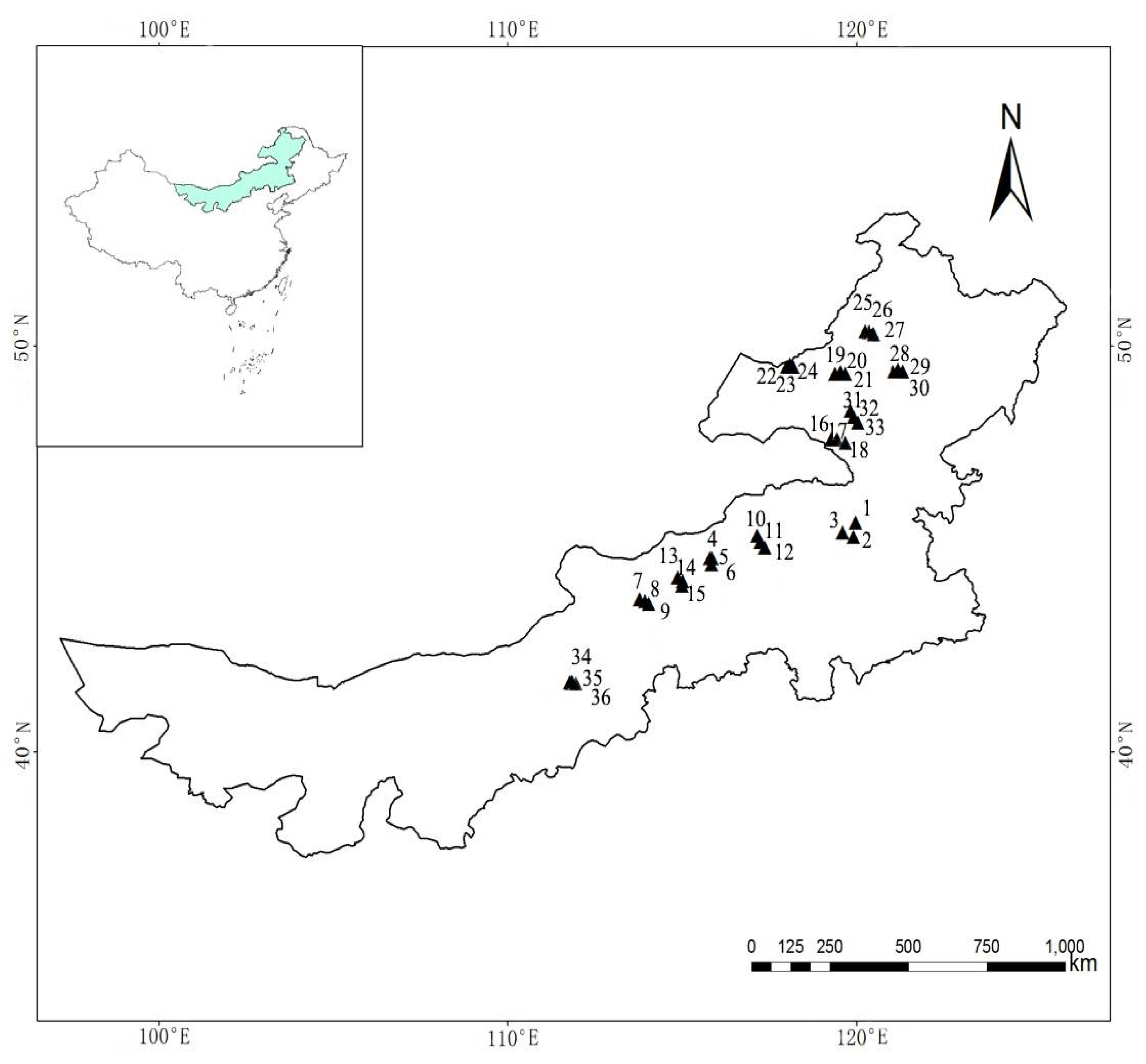
2.1. Study Area

The study was conducted in the Inner Mongolia Autonomous Region, Northern China (Figure 1). The study region spans roughly 41.70°–50.36° N and 111.77°–121.06° E, with an altitude ranging from 553.40 to 1486.15 m above sea level, and forms a 1200 km belt transect across Inner Mongolia grassland. The climate of the region is temperate continental monsoon climate, with a mean annual temperature varying from −1.9 to 8.6 °C, and a mean annual precipitation of 150–450 mm from northeast to southwest. Three major types of soil can be distinguished: chernozem, chestnut, and brown calcium soils [17]. Local vegetations mainly comprise two subtypes: typical and meadow grasslands, which are dominated by Carex pediformis, Stipa baicalensis, Leymus chinensis, Elymus dahurica, Stipa grandis, Stipa sareptana var. krylovii, and Cleistogenes squarrosa in the Inner Mongolia grassland.

2.2. Sampling Design

Field investigation and sampling were conducted in July and August of 2018, which is the most optimal growth period for grassland plants [26]. Based on the temperature, precipitation, and vegetation distribution patterns, 36 sampling sites were selected spanning Hulunbuir League in the northeast to Ulanqab City in the south−central region, including 21 sites in the typical steppe (S4, S5, S6, S7, S8, S9, S10, S11, S12, S13, S14, S15, S19, S20, S21, S22, S23, S24, S34, S35, S36) and 15 sites (S1, S2, S3, S16, S17, S18, S25, S26, S27, S28, S29, S30, S31, S32, S33) in the meadow steppe, which included most of the dominant species and main vegetation types.
The mean richness of 1 m2 quadrat presumably reflects biotic interaction relationships and local environmental conditions [3,27,28]. At each of the 36 sites, a place of 10 m ’10 m which was homogeneous in terms of vegetation structure was identified, and three representative quadrats with 1 m2 within the 10 m × 10 m were randomly selected for plant and soil sampling by avoiding the low−lying, steep slopes, and residential area, and a total of 108 quadrats were obtained. Each quadrat was investigated for species composition, numbers, height, covers of all vascular plants, and all vascular plants in 1 m2 quadrat were harvested to measure aboveground biomass [29]. Finally, aboveground biomass samples were oven−dried at 65 °C until constant mass and weighed to the nearest 0.1 g in the laboratory.
A handheld GPS device was used to obtain the positioning of each site, and the longitude, latitude, and altitude were recorded. Additionally, mixed soil samples were collected from the layers of 0–30 cm soil profiles.

2.3. Measurement and Acquisition of Ecological Factors

Climate data were obtained from the China Meteorological Data Network (http://data.cma.cn (accessed on 7 December 2019)). Each sampling site selected the meteorological station on a regional scale. Extracted data included temperature and precipitation of the growing season for each site in 2018. Monthly average temperature and accumulated precipitation in the growing season were regarded as climatic factors. Total carbon (TC) and nitrogen (TN) in the soil were determined by element analyzer (VarioEL III, Elementer, Germany), and total phosphorus (TP) in the soil was extracted by H2SO4–HClO4 fusion and determined by UV 7600 spectrophotometer [30].

2.4. Data Processing and Analysis

Importance value (IV) was calculated by density, height, coverage, and biomass of plants as follows:
I V = ( Ab i Ab s + He i He s + Co i Co s + Bio i Bio s ) / 4
where IV is the importance value, and Abi, Hei, Coi, and Bioi are abundance, coverage, height, and above-ground biomass, respectively, of species i in sample plots, while Abs, Hes, Cos, and Bios are the total abundance, total coverage, total height, and total above-ground biomass, respectively, in sample plot s.
Species diversity includes Richness (R), Shannon-Wiener’s index of diversity (H′), and Pielou’s index of evenness (E) in this study [31,32].
Species richness:
R = S
Shannon-Wiener’s index of diversity:
H = i = 1 S P i L n ( P i )
Pielou’s index of evenness:
E = H L n ( s )
where S is the number of species recorded in quadrats; Pi is the relative abundance of the ith species, Pi = Ni/N. Ni is the absolute importance value of species i. N is the sum of absolute importance values of all species in a quadrat of species i.
Vegetation data were the matrix of IV of samples and species, and TWINSPAN classification was used to classify different groups. Communities were classified on the basis of the combination of TWINSPAN analysis and DCA analysis. Specific names of the dominant species were arranged in order, and the dominant species were concatenated with “+”. RDA was utilized to analyze the effect of ecological factors on the differentiation characteristics of the plant community. TWINSPAN analysis was completed by PC-ORD 5.0 [33], DCA and RDA sorting were completed by Canoco 5.0 [34].

3. Results

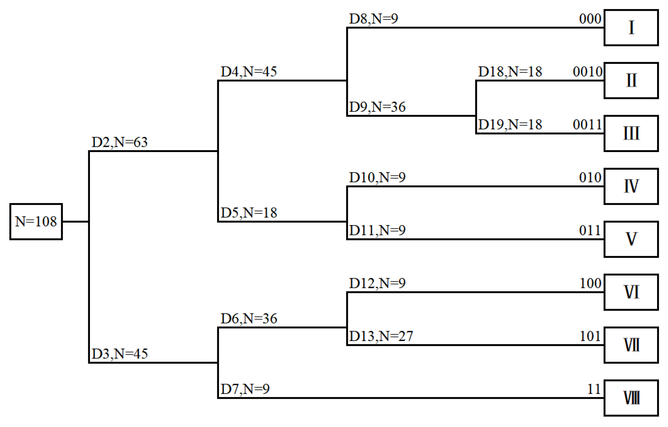
3.1. TWINSPAN Classification of Grassland Communities

A total of 140 vascular plants belonging to 31 families and 79 genera, were recorded in 36 sampling sites. The plants of Compositae, Poaceae, Rosaceae, and Fabaceae were common species. According to the results of the fourth TWINSPAN classification and the field investigation data, the related branches of the community were merged by a five-level division method (0.00, 0.02, 0.05, 0.10, and 0.20), and eight groups were finally obtained in Figure 2 and Table 1.
I.
Stipa sareptana var. krylovii + Dysphania aristata, included three sites (S34, S35, S36), with low species richness, and a total of 16 plants. S. sareptana var. krylovii was the dominant species, D. aristata and S. bungeana were the suboptimal species. The total vegetation cover was 70−76%, the diversity and aboveground biomass were at the medium levels, while the evenness was relatively high.
II.
Stipa grandis + Leymus chinensis, included three sites (S10, S11, S12), with medium species richness, and a total of 19 plants. S. grandis was the dominant species, L. chinensis was the suboptimal species. The total vegetation cover was 78%−82%, the species diversity, and evenness were both high, while aboveground biomass was at a medium level.
III.
Stipa sareptana var. krylovii + Leymus chinensis, included nine sites (S4, S5, S6, S7, S8, S9, S13, S14, S15), with a total of 33 plants. S. sareptana var. krylovii was the dominant species, L. chinensis, C. squarrosa, and Allium ramosum were suboptimal species. The total vegetation cover was 52−76%, and the species diversity, evenness, and aboveground biomass were relatively low.
IV.
Stipa grandis+ Cleistogenes squarrosa, included three sites (S22, S23, S24), with a total of 16 plants. S. baicalensis was the dominant species, C. squarrosa was the suboptimal species. The total vegetation cover was 88%−92%. The species richness, species diversity, and evenness were all at the medium levels, while aboveground biomass was high.
V.
Stipa grandis + Carex duriuscula, included three sites (S19, S20, S21), with low species richness, and a total of 15 plants. S. grandis and C. duriuscula were both dominant species. The total vegetation cover was 90−95%. The species diversity, evenness, and aboveground biomass were all low.
VI.
Stipa baicalensis + Leymus chinensis, included three sites (S1, S2, S3), with a total of 31 plants. The dominant species was S. baicalensis, L. chinensis was the suboptimal species. The total vegetation cover was 90−95%. The species diversity and evenness were in the medium levels, while the mean aboveground biomass was prominent.
VII.
Carex pediformis + Stipa baicalensis, included nine sites (S16, S17, S18, S25, S26, S27, S31, S32, S33), with very high species richness, and a total of 69 plants. C. pediformis and S. baicalensis were both dominant species, the Agropyron cristatum was the suboptimal species. The total vegetation cover was 89−99%. The evenness was low, while the aboveground biomass was the highest (230.67 g·m−2).
VIII.
Leymus chinensis + Elymus dahuricus, included three sites (S28, S29, S30), with a total of 30 plants. L. chinensis and E. dahuricus were both the dominant species. The total vegetation cover was 97−98%. The species diversity, evenness, and aboveground biomass were relatively high.
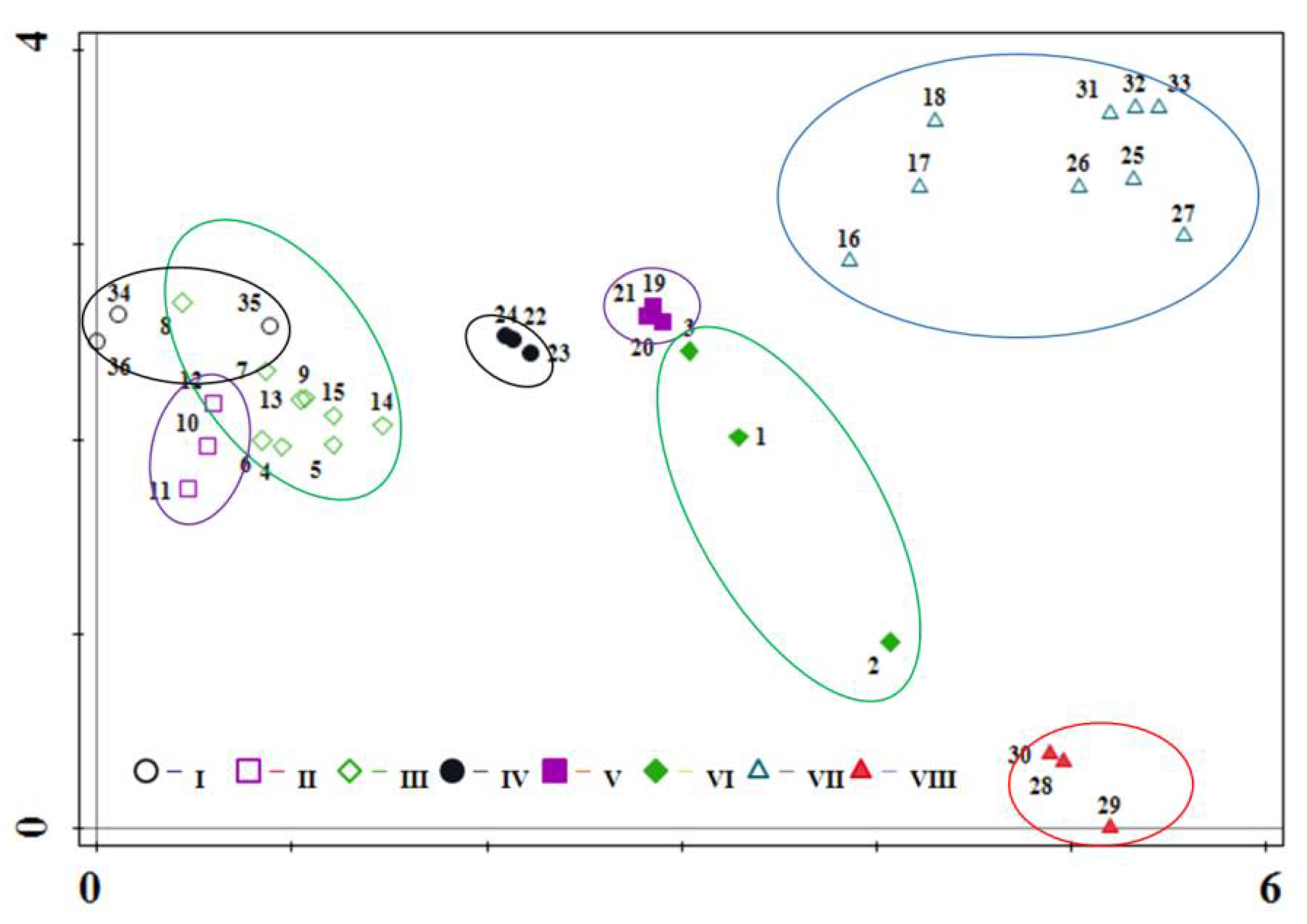
3.2. DCA Ordination

The eigenvalues of the four sorting axes were 0.8053, 0.5071, 0.2824, and 0.2235, respectively, in the order of their numerical values. The first two ordination axes contained a large amount of information, which could indirectly reflect the important ecological significance of the community. According to the DCA ordination diagram, each community type showed regular distribution. A two-dimensional sorting diagram was plotted based on the first two DCA axes (0.8053 and 0.5071) (Figure 3). Group I, II, and III; were distributed in the left of the sorting axis, the species composition and suitable habitats of the group I, group II, and group III with S. sareptana var. krylovii and L. chinensis as the dominant species were similar at the community level, and most of them were distributed in a semi-arid region in the Inner Mongolia grassland, where the average temperature and accumulated precipitation in the growing season were approximately 20.2 °C and 160.32 mm, respectively. Group IV and V were distributed in the middle of the sorting axis, S. grandis and other forbs were the dominant species in slightly semi-arid habitats, where the average temperature and accumulated precipitation in the growing season were approximately 18.8 °C and 222.95 mm, respectively. However, the groups VI, VII, and VIII were distributed in the right of the sorting axis and located in the semi−humid area, where the average temperature and accumulated precipitation in the growing season were approximately 18.6 °C and 254.28 mm, respectively. These groups with S. baicalensis, C. pediformis, L. chinensis, and E. dahuricus as the dominant species were located in the cold and humid region.
TWINSPAN results showed that the clusters I, II, III, and VIII belonged to weak variations, while those in groups VI and VII showed strong variations. Regarding variations among the communities, groups IV and V showed subtle differences, even overlapped, while other groups demonstrated specific characteristics, showing community heterogeneity.

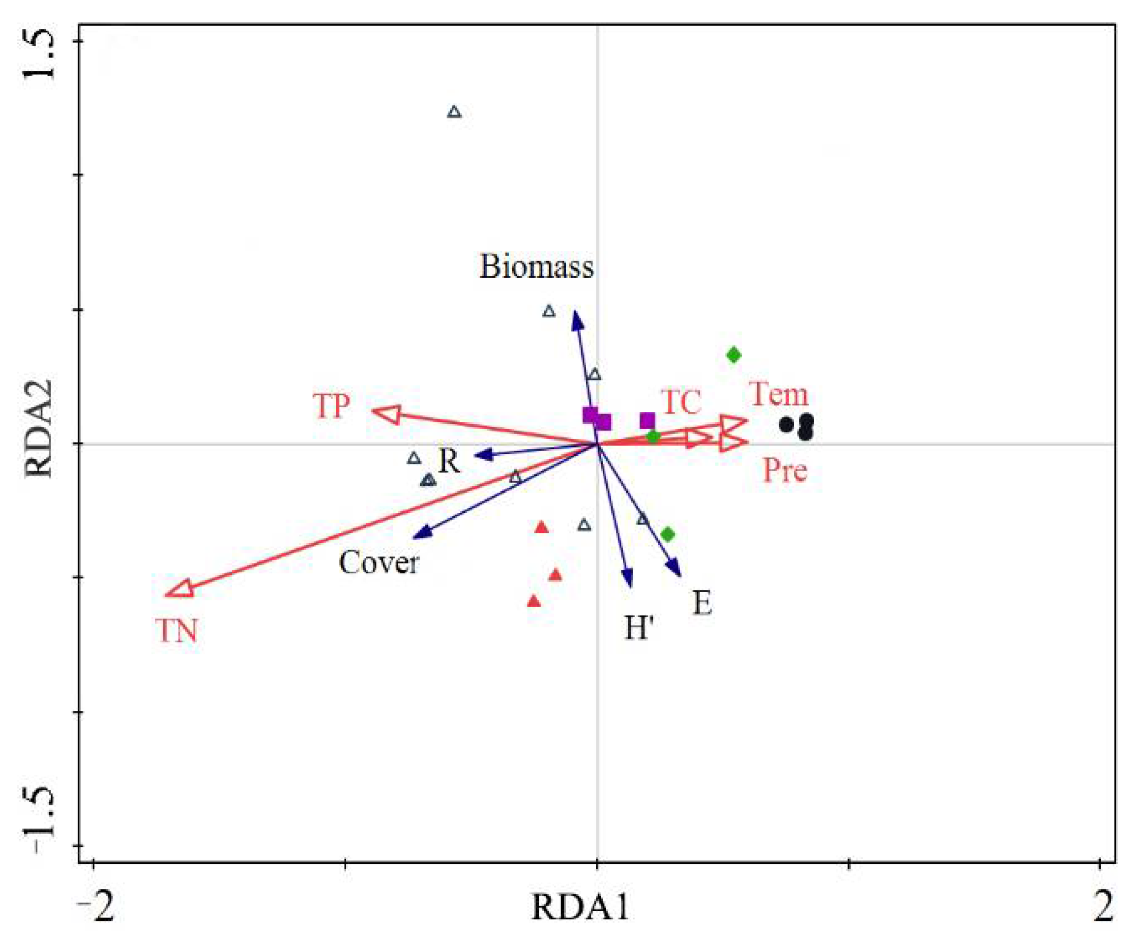
3.3. RDA Analysis in the Meadow Steppe

A total of five community characteristics and five ecological factors in the study area were analyzed by RDA analysis. To offset the influence of redundant variables, the simple and conditional effects of five ecological factors were obtained by the forward selection and Monte Carlo test (Figure 4 and Table 2).
The eigenvalues of the four ordination axes of RDA were 0.214, 0.143, 0.029, and 0.006, respectively, and the environmental interpretation of plant community differentiation characteristics was 39.1%. RDA results showed that ecological factors exhibited a significant correlation with the first axis. Average temperature, accumulated precipitation, and total carbon had a positive correlation with the first axis. Total phosphorus and total nitrogen had a negative correlation with the first axis. Along the first axis, soil total nitrogen showed significant positive correlations with community cover and species richness. The average temperature and accumulated precipitation in the growing season were also dominant factors affecting the community characteristics opposite to the total phosphorus and total nitrogen, which showed a significant negative correlation with community cover and species richness. Furthermore, total carbon had a significant negative correlation with the community cover and species richness. Total nitrogen ranked first place among the conditional variables relating to the effect on community differentiation characteristics, with simple effects of 18.8%, accounting for 48% of total environmental variance. The second and third influencing factors were the average temperature and accumulated precipitation in the growing season, with the simple effects of 8.4% and 8%, respectively, accounting for 21.5% and 20.4% of the total environmental variance, respectively. Additionally, the influence of the average temperature and accumulated precipitation in the growing season in the meadow steppe was similar. Conditional effects were greater than simple effects from a comprehensive perspective, indicating complex relationships among environmental variables in the meadow steppe.

3.4. RDA Analysis in the Typical Steppe

The eigenvalues of the four ordination axes of RDA were 0.456, 0.150, 0.058, and 0.004, respectively, and the accumulated environmental interpretation of the plant community differentiation characteristics was 66.8% (Figure 5 and Table 3). The results of RDA presented a great correlation between ecological factors and the first axis. Accumulated precipitation, total phosphorus, total nitrogen, and total carbon in the growing season had a negative correlation with the first axis. The average temperature in the growing season had a positive correlation with the first axis. Along the first axis of RDA from left to right, the accumulated precipitation in the growing season decreased gradually and had positive correlations with vegetation cover, evenness, aboveground biomass, and Shannon−Wiener diversity. The average temperature in the growing season was positively correlated with the richness index, and negatively correlated with aboveground biomass, vegetation cover, and evenness. Furthermore, community characteristics were positively correlated with total phosphorus, total nitrogen, and total carbon.
Accumulated precipitation in the growing season had the largest impact on community characteristics, with simple impacts of 42.5%, accounting for 63.6% of the total environmental variance. The simple effects of total phosphorus in the second rank were 39.6%, while the conditional effects were reduced to 15.3% after eliminating the effect of accumulated precipitation in the growing season, indicating that a strong correlation existed between total phosphorus and accumulated precipitation. Upon excluding the accumulated precipitation in the growing season, the conditional effects of other ecological factors decreased, reflecting the complex correlation between the accumulated precipitation and other ecological factors in the growing season. The accumulated precipitation and total phosphorus shaped community characteristics in the typical steppe. The effect of average temperature in the growing season on the community differentiation characteristics ranked third place.

4. Discussion

4.1. Spatial Differentiation Characteristics of Plant Community in the Inner Mongolia Grassland

Based on TWINSPAN quantitative classification, a total of 36 sampling sites in the Inner Mongolia grassland were divided into eight groups, which can be classified into two vegetation subtypes according to the ‘Vegetation Atlas of China’ and geographical location: (1) The typical steppe dominated by S. sareptana var. krylovii and S. grandis, included five community types: Cluster Stipa sareptana var. krylovii + Dysphania arista, Cluster Stipa grandis + Leymus chinensis, Cluster Stipa sareptana var. krylovii + Leymus chinensis, Cluster Stipa grandis + Cleistogenes squarrosa, and Cluster Stipa grandis + Carex duriuscula. (2) The meadow steppe dominated by C. pediformis and S. baicalensis, included three community types: Cluster Stipa baicalensis + Leymus chinensis, and Cluster Carex pediformis + Stipa baicalensis, and Cluster Leymus chinensis + Elymus dahuricus. Results of plant community division are similar to previous studies in the Inner Mongolia grassland [17,35]. The similarities between Cluster Stipa sareptana var. krylovii + Dysphania arista, Cluster Stipa grandis + Leymus chinensis, and Cluster Stipa sareptana var. krylovii + Leymus chinensis were very high, which may be corroborated with high−intensity environmental selection. From the perspective of community structure and species composition, we found that Stipa had undergone regional differentiation and species adaptation in typical and meadow steppes along the precipitation gradients of the growing season: S. baicalensis, S. grandis, and S. sareptana var. krylovii, showing wide ecological adaptability of Stipa species.
Grasslands show a global maxima in fine-scale plant community diversity [36]. Species richness is an important index both for community ecology and biodiversity conservation. In this study, we found that the species richness means of 1-m2 plots was approximately 10 in the typical steppe and 18 in the meadow steppe, respectively. Most plots included between 7–22 species, which presented community differentiation characteristics between typical steppe and meadow steppe on a regional scale. Previous scholars also proved that species richness had a regional differentiation on a different scale. Chen et al. used quantitative sorting methods to explore species distribution of meadow grassland vegetation in Hulunbuir grassland and found the species richness means of 1-m2 plots were 20.1, this conclusion was consistent with our results in the meadow steppe [18]. Hájek et al. studied the vegetation composition of permanent plots in extremely species-rich temperate grasslands in White Carpathians and found that species richness of 1-m2 plots varied between 43 and 82, with the mean value being 57.6 [28]. Compared to the above region, the species richness of the Inner Mongolia grasslands was lower than that of temperate grasslands along the same latitude in White Carpathians, which may be linked to geographical location and climatic factors.
As an important index of community or ecosystem productivity, biomass is also the main embodiment of community or ecosystem functions in different ecosystems [37,38], especially grassland ecosystems [9,11,24,39]. Previous studies have illustrated that the above-ground biomass in a community dominated by S. sareptana var. Krylovii was 111.61 g·m2, and the global above-ground biomass of 430.2 g·m2 [40,41]. In this study, we found that the above biomass mean of 1-m2 plots was approximately 111.1 g·m2 in the typical steppe, and 203.4 g·m2 in the meadow steppe, respectively, indicating that the meadow steppe had higher productivity than that of the typical steppe. The above-ground biomass in the typical steppe was consistent with the study of Lu et al. [40], while lower than the global above-ground biomass [41], indicating that more efforts in biodiversity conservation and grassland protection are needed. Furthermore, the research on the ecosystem functions and stability based on biomass will perhaps become a heated ecology topic in the future.

4.2. Influencing Factors of Plant Community Characteristics in the Inner Mongolia Grassland

Climate, soil properties, and human management all influence the community composition of the vegetation [42]. Precipitation and temperature are the main factors affecting the spatial differentiation of large-scale communities, while the soil nutrients are the main factors affecting the spatial distribution of small-scale communities or microtopography [43]. Considering the large scale of the study area, climate patterns varied from monsoon climate to the temperate continental climate, and soil types included chernozem, chestnut, and brown calcium soils [17]. What is more, the response of the structure and functional characteristics of the plant community to the different ecological factors was complex and heterogeneity across a 1200 km belt transect in the Inner Mongolia grassland.
The RDA analysis of the four sortings provided environmental interpretation for community differentiation characteristics as high as 66.8%, further explaining that the spatial differentiation characteristics of plant communities along latitude gradients in the Inner Mongolia grassland were mainly modulated by the process of environmental filtering [44]. In the meadow steppe, Cluster Carex pediformis + Stipa baicalensis was the main vegetation type, and the variation among the clusters was clear, which may be explained by the suitable growth season and sufficient soil nutrients. In this study, DCA analysis revealed that the community differentiation of typical and meadow steppes may be linked to precipitation in meadow and typical steppes. Stipa species had undergone regional differentiation from meadow steppe to typical steppe in sampling plots as following: S. baicalensis, S. grandis, and S. sareptana var. krylovii, which due to that the accumulated precipitation during the growing season (223.95 mm) in Hulunbuir typical steppes was higher than that in Xilingol League and Ulanqab City steppes (160.32 mm), and S. grandis was the dominant species in the former, while S. sareptana var. Krylovii was the dominant species in the latter, while S. baicalensis located in the meadow steppe appeared in the sub-humid habitats with accumulated precipitation of 254.28 mm, which also reflected the regional water-based species differentiation of Stipa. This conclusion was also mentioned in the basic characteristics of S. sareptana var. krylovii communities in China [40,45]. Additionally, the contribution rate of accumulated precipitation in the growing season to the differentiation of community characteristics was 63.6%, and the conditional effects were 42.5%, which proved that precipitation was the most critical factor driving the zonal distribution of vegetation in the typical steppe. This finding exactly coincided with the study conducted by Fang et al. [46] and Bai et al. [47,48]. When only environmental factors were considered, the temperature had a positive effect on vegetation types [49]. In this study, the contribution rates of average temperature and precipitation in the growing season to the community characteristics in the meadow steppe were similar, and the accumulated environmental interpretation of climatic factors on the plant community characteristic differentiation was 41.9%. On the other hand, except for precipitation and temperature, other meteorological factors like wind and relative air humidity, which may influence community structure were not mentioned in this study, so we also pay attention to the effect of more meteorological factors on community characteristics and function in the future research.
The influence of microtopography is mainly reflected in the difference in soil nutrients. In this study, the Cluster Leymus chinensis + Elymus dahuricus had certain differences with other plant communities, which may be linked to microtopography. Ma et al. also proved that microtopography had a certain effect on the differentiation of plant community characteristics [50]. Previous studies have revealed that soil factors influenced species diversity by accumulated environmental interpretation of 12.48% and confirmed soil organic matter as a dominant factor according to a plant community study in Hulunbuir grassland [19]. In this study, accumulated environmental interpretation of the soil nitrogen factors on the plant community characteristics differentiation in the meadow steppe was 18.8% and proved that total nitrogen was the major influencing factor, this finding exactly coincided with the results in semi-arid grasslands [21]. The contribution rate of soil total phosphorus to the plant community characteristics differentiation ranked second place with conditional effects of 15.3%. Previous studies have proved that soil phosphorus had a significant influence on community productivity and species richness [51,52]. Similarly, total phosphorus had a significant impact on the variation of community characteristics in this study (p < 0.01). This finding may be explained by increased nitrogen assimilation in the grassland of northern China, which in turn affected the absorption of phosphorus in a fashion, this conclusion has also been confirmed by relevant scholars [53,54], thus the research on phosphorus availability or stoichiometric characteristics may be a research subject in the future.

5. Conclusions

This study investigated herbaceous plant communities in different steppes of the Inner Mongolia grassland and revealed the differentiation characteristics and influencing factors of temperate grassland vegetation across a 1200 km belt transect, which is essential for understanding how community structure and function will respond to future climate change. In this study, the field survey recorded 140 herbaceous plants, with S. baicalensis, S. grandis, S. sareptana var. Krylovii, L. chinensis, and C. duriuscula as the dominant species. Grassland vegetation was divided into eight typologies on the basis of the TWINSPAN and DCA analysis. This study preliminarily revealed that the spatial differentiation characteristics of temperate grassland vegetation, that is, the environmental filtering mechanism in the Inner Mongolia grassland was more obvious along the environmental gradients. Precipitation significantly affected community differentiation in the typical steppe, while the contribution rates of water and heat in the meadow steppe were equally significant, and total nitrogen showed the most significant influence on the differentiation characteristics of the plant community in the meadow steppe. On the whole, precipitation zonality and soil nutrients in the meadow steppe resulted in the differentiation of vegetation. Soil nutrient, especially soil nitrogen, was the main influencing factor in the relatively humid meadow steppe, while precipitation was the main influencing factor in the relatively dry typical steppe, revealing that the effects of precipitation and nutrients on community differentiation were coupled. Thereby the coupling mechanism of environmental and climatic factors on community, and the mechanism of maintaining the structure and function of grassland community may be a research subject in the future.

Author Contributions

Conceptualization, Z.F. and Z.L.; Formal analysis, Z.F. and F.W.; Funding acquisition, Z.L. and M.Z.; Investigation, Z.F., F.W., M.Z. and L.Z. (Lin Zhang); Project administration, Z.L.; Resources, Z.F., L.Z. (Lin Zhang), W.H., Y.J., B.G., R.C. and B.W.; Software, Z.F., L.Z. (Ling Zhao), W.H., Y.J. and B.G.; Supervision, Z.L.; Writing—original draft, Z.F. and F.W.; Writing—review & editing, Z.F. and Z.L. All authors have read and agreed to the published version of the manuscript.

Funding

This work was supported by the National Key Research and Development Program of China (Funder: Zhaohua Lu, 2016YFC0501108); DongMing Corporation Technology Research and Development Program (Funder: Meng Zhang, DMHTA2012386); China Energy Investment Science and Technology Innovation Program (Funder: Meng Zhang, HT (2020) 2337).

Institutional Review Board Statement

Not applicable.

Informed Consent Statement

Not applicable.

Data Availability Statement

The data presented in this study are available on request from the corresponding author. The data are not publicly available due to data which also forms part of an ongoing study.

Conflicts of Interest

The authors declare no conflict of interest, and the manuscript has been approved by all authors for publication.

References

  1. Hooper, D.U.; Chapin, F.S.; Ewel, J.J.; Hector, A.; Inchausti, P.; Lavorel, S.; Lawton, J.H.; Lodge, D.M.; Loreau, M.; Naeem, S.; et al. Effects of biodiversity on ecosystem functioning: A consensus of current knowledge. Ecol. Monogr. 2005, 75, 3–35. [Google Scholar] [CrossRef]
  2. Jochum, M.; Fischer, M.; Isbell, F.; Roscher, C.; Plas, F.V.D.; Boch, S.; Boenisch, G.; Buchmann, N.; Catford, J.A.; Jeannine Cavender-Bares, J.; et al. The results of biodiversity−ecosystem functioning experiments are realistic. Nat. Ecol. Evol. 2020, 4, 1485–1494. [Google Scholar] [CrossRef] [PubMed]
  3. Li, W.H.; Hooper, D.U.; Wu, L.J.; Bakker, J.; Gianuca, A.T.; Wu, X.B.; Taube, F.; Wang, C.N.; Bai, Y.F. Grazing regime alters plant community structure via patch-scale diversity in semiarid grasslands. Ecosphere 2021, 12, e03547. [Google Scholar] [CrossRef]
  4. Parton, W.J.; Scurlock, J.M.O.; Ojima, D.S.; Gilmanov, T.G.; Scholes, R.J.; Schimel, D.S.; Kirchner, T.; Menaut, J.C.; Seastedt, T.; Moya, E.G.; et al. Observation and modeling of biomass and soil organic matter dynamics for the grassland biome worldwide. Glob. Biogeochem. Cycles 1993, 7, 785–809. [Google Scholar] [CrossRef] [Green Version]
  5. Wang, X.F.; Lesi, M.C.; Zhang, M.M. Ecosystem pattern change and its influencing factors of “two barriers and three belts”. Chin. J. Ecol. 2019, 38, 2138–2148. [Google Scholar]
  6. Kong, Y.Y.; Luo, Q.Y.; Chen, Z. Study on the characteristic of vegetation composition and community succession of alpine meadow under three management modes. J. Yunnan Agric. Univ. Nat. Sci. 2020, 35, 1046–1053. [Google Scholar]
  7. Roscher, C.; Schumacher, J.; Gubsch, M.; Lipowsky, A.; Weigelt, A.; Buchmann, N.; Schmid, B.; Schulze, E.D. Using plant functional traits to explain diversity-productivity relationships. PLoS ONE 2012, 7, e36760. [Google Scholar] [CrossRef] [PubMed]
  8. Fraser, L.H.; Pither, J.; Jentsch, A.; Sternberg, M.; Zobel, M.; Askarizadeh, D.; Bartha, S.; Beierkuhnlein, C.; Bennett, J.A.; Bittel, A.; et al. Worldwide evidence of a unimodal relationship between productivity and plant species richness. Science 2015, 349, 302–305. [Google Scholar] [CrossRef] [Green Version]
  9. Zhu, J.T.; Jiang, L.; Zhang, Y. Relationships between functional diversity and aboveground biomass production in the Northern Tibetan alpine grasslands. Sci. Rep. 2016, 6, 34105. [Google Scholar] [CrossRef] [Green Version]
  10. Dong, S.K.; Tang, L.; Zhang, X.F.; Liu, S.L.; Liu, Q.R.; Su, X.K.; Zhang, Y.; Wu, X.Y.; Zhao, Z.Z.; Li, Y.; et al. Relationship between plant species diversity and functional diversity in alpine grasslands. Acta Ecol. Sin. 2017, 37, 1472–1483. [Google Scholar]
  11. Zhang, Q.; Buyantuev, A.; Li, F.Y.H.; Jiang, L.; Niu, J.M.; Ding, Y.; Kang, S.; Ma, W.J. Functional dominance rather than taxonomic diversity and functional diversity mainly affects community aboveground biomass in the Inner Mongolia grassland. Ecol. Evol. 2017, 7, 1605–1615. [Google Scholar] [CrossRef] [PubMed]
  12. Dai, C.; Kang, M.Y.; Ji, W.Y.; Jiang, Y. Responses of belowground biomass and biomass allocation to environmental factors in central grassland of Inner Mongolia. Acta Agrestia Sin. 2012, 20, 268–274. [Google Scholar]
  13. Dorji, T.; Moe, S.R.; Klein, J.A.; Totland, Ø. Plant species richness, evenness, and composition along environmental gradients in an alpine meadow grazing ecosystem in central Tibet, China. Arct. Antarct. Alp. Res. 2014, 46, 308–326. [Google Scholar] [CrossRef] [Green Version]
  14. Zhang, Q.; Hou, X.Y.; Li, F.Y.H.; Niu, J.M.; Zhou, Y.L.; Ding, Y.; Zhao, L.Q.; Li, X.; Ma, W.J.; Kang, S. Alpha, beta and gamma diversity differ in response to precipitation in the Inner Mongolia grassland. PLoS ONE 2014, 9, e935183. [Google Scholar] [CrossRef] [PubMed]
  15. Ding, X.J.; Su, P.X.; Zhou, Z.J.; Shi, R. Belowground bud bank distribution and aboveground community characteristics along different moisture gradients of alpine meadow in the Zoige plateau, China. Sustainability 2019, 11, 2602. [Google Scholar] [CrossRef] [Green Version]
  16. Adomou, A.C.; Akoègninou, A.; Sinsin, B.; Foucault, B.D.; Maesen, L.J.G.V.D. Notulae Florae Beninensis, 13-Biogeographical analysis of the vegetation in Benin. Acta Bot. Gall. 2007, 154, 221–233. [Google Scholar] [CrossRef]
  17. Wang, Y.H.; Zhao, M.F.; Kang, M.Y. Distribution pattern of main steppe communities in Inner Mongolia region and environmental interpretation. J. Beijing Norm. Univ. Nat. Sci. 2016, 52, 83–90. [Google Scholar]
  18. Chen, B.R.; Zhu, Y.X.; Zhang, H.B.; Zhou, L.; Xin, X.P. Quantitative classification and ordination of meadow grassland vegetations in Hulunber. J. Wuhan Bot. Res. 2008, 26, 476–481. [Google Scholar]
  19. Chen, B.R.; Li, H.S.; Zhu, Y.X.; Li, G.; Xin, X.P.; Zhang, H.B.; Zhou, L. The spatial pattern and environmental interpretation of the plant community of Hulunber grassland. Acta Ecol. Sin. 2010, 30, 1265–1271. [Google Scholar]
  20. Sha, W.; Dong, S.K.; Liu, S.L.; Liu, Q.R.; Shi, J.B.; Li, X.W.; Su, X.K.; Wu, Y. Spatial patterns of plant community biomass and species diversity in Aerjin Mountain Nature Reserve and their influencing factors. Chin. J. Ecol. 2016, 35, 330–337. [Google Scholar]
  21. Fu, Z.Y.; Jiang, H.; Wang, G.Q.; Xue, B.L.; Wang, H.Q. Effects of soil properties on plant community structure in a semi−arid grassland. Chin. J. Ecol. 2018, 37, 823–830. [Google Scholar]
  22. Wang, Y.T.; Bi, Y.T.; Wang, Q.; Hao, H.C.; Xu, M.H. Spatial differentiation of plant species diversity in subalpine meadows in Shanxi Province. Chin. Agric. Sci. Bull. 2018, 34, 77–83. [Google Scholar]
  23. Shan, D.; Zhu, Y.J.; Liu, Y.S.; Shi, Z.J.; Yang, X.H. Differentiation of vegetation types and biodiversity in the southern edge of Hulunbuir grassland. Chin. J. Ecol. 2019, 38, 619–626. [Google Scholar]
  24. Klaus, V.H.; Whittingham, M.J.; Báldi, A.; Eggers, S.; Francksen, R.M.; Hiron, M.; Lellei-Kovacs, E.; Rhymer, C.M.; Buchmann, N. Do biodiversity−ecosystem functioning experiments inform stakeholders how to simultaneously conserve biodiversity and increase ecosystem service provisioning in grasslands? Biol. Conserv. 2020, 245, 108552. [Google Scholar] [CrossRef]
  25. Chinese Academy of Sciences. Vegetation Atlas of China; Science Press: Beijing, China, 2001. [Google Scholar]
  26. Bai, Y.F.; Han, X.G.; Wu, J.G.; Chen, Z.Z.; Li, L.H. Ecosystem stability and compensatory effects in the Inner Mongolia grassland. Nature 2004, 431, 181–184. [Google Scholar] [CrossRef]
  27. Ma, K.P.; Huang, J.H.; Yu, S.L.; Chen, L.Z. Plant community diversity in Dongling Mountain, Beijing, China: II Species richness, evenness and species diversity. Acta Ecol. Sin. 1995, 15, 268–277. [Google Scholar]
  28. Hájek, M.; Hájková, P.; Roleček, J. A novel dataset of permanent plots in extremely species-rich temperate grasslands. Folia Geobot. 2020, 55, 257–268. [Google Scholar] [CrossRef]
  29. Yang, Y.H.; Fang, J.Y.; Ma, W.H.; Guo, D.L.; Mohammat, A. Large-scale pattern of biomass partitioning across China’s grasslands. Glob. Ecol. Biogeogr. 2010, 19, 268–277. [Google Scholar] [CrossRef]
  30. Bao, S.D. Agricultural and Chemistry Analysis of Soil; Chinese Agriculture Press: Beijing, China, 2000. [Google Scholar]
  31. Liu, C.R.; Ma, K.P.; Yu, S.L.; Wang, W. Plant community diversity in Dongling Mountain, Beijing, China: IV. Effects of sample size on diversity measures. Acta Ecol. Sin. 1997, 17, 584–592. [Google Scholar]
  32. Nie, Y.Y.; Chen, J.Q.; Xin, X.P.; Xu, L.J.; Yang, G.X.; Wang, X. Responses of niche characteristics and species diversity of main plant populations to duration of enclosure in the Hulun Buir meadow steppe. Acta Prataculturae Sin. 2021, 30, 15–25. [Google Scholar]
  33. Grandin, U. PC-ORD version 5: A user-friendly toolbox for ecologists. J. Veg. Sci. 2005, 17, 843–844. [Google Scholar] [CrossRef]
  34. Lai, J.S. Canoco 5: A new version of an ecological multivariate data ordination program. Biodiversity. Sci. 2013, 21, 765–768. [Google Scholar]
  35. Bai, Y.F.; Li, L.H.; Wang, Q.B.; Zhang, L.X.; Zhang, Y.; Chen, Z.Z. Changes in plant species diversity and productivity along gradients of precipitation and elevation in the Xinlin River Basin. Acta Phytoecol. Sin. 2000, 24, 667–673. [Google Scholar]
  36. Chytrý, M.; Otýpková, Z. Plot sizes used for phytosociological sampling of European vegetation. J. Veg. Sci. 2003, 14, 563–570. [Google Scholar] [CrossRef]
  37. Shen, X.J.; Jiang, M.; Lu, X.G.; Liu, X.T.; Liu, B.; Zhang, J.Q.; Wang, X.W.; Tong, S.Z.; Lei, G.C.; Wang, S.Z.; et al. Aboveground biomass and its spatial distribution pattern of herbaceous marsh vegetation in China. Sci. China Earth Sci. 2021, 64, 1115–1125. [Google Scholar] [CrossRef]
  38. Xu, Y.J.; Zhang, Y.; Li, W.; Liu, W.Y.; Gu, X.; Guan, Z.H.; Yang, J.; Lu, Z.Y. Effects of tree functional diversity and environmental gradients on belowground biomass in a natural old-growth forest ecosystem. Can. J. For. Res. 2019, 49, 1623–1632. [Google Scholar] [CrossRef]
  39. Zuo, W.Q.; Wang, Y.H.; Wang, F.Y.; Shi, G.X. Effects of enclosure on the community characteristics of Leymus chinensis in degenerated steppe. Acta Prataculturae Sin. 2009, 18, 12–19. [Google Scholar]
  40. Lu, S.Z.; Qiao, X.G.; Zhao, L.Q.; Wang, Z.; Gao, C.G.; Wang, J.; Guo, K. Basic characteristics of Stipa sareptana var. krylovii communities in China. Chin. J. Plant Ecol. 2020, 44, 1087–1094. [Google Scholar] [CrossRef]
  41. Mokany, K.; Raison, R.J.; Prokushkin, A.S. Critical analysis of root: Shoot ratios in terrestrial biomes. Global Change Biol. 2006, 12, 84–96. [Google Scholar] [CrossRef]
  42. Manning, P.; Vries, F.T.D.; Tallowin, J.R.B.; Smith, R.; Mortimer, S.R.; Pilgrim, E.S.; Harrison, K.A.; Wright, D.G.; Quirk, H.; Benson, J.; et al. Simple measures of climate, soil properties and plant traits predict national-scale grassland soil carbon stocks. J. Appl. Ecol. 2015, 52, 1188–1196. [Google Scholar] [CrossRef] [Green Version]
  43. Siefert, A.; Ravenscroft, C.; Althoff, D.; Alvarez−Yépiz, J.C.; Carter, B.E.; Glennon, K.L.; Heberling, J.M.; Jo, I.S.; Pontes, A.; Sauer, A.; et al. Scale dependence of vegetation−environment relationships: A meta-analysis of multivariate data. J. Veg. Sci. 2012, 23, 942–951. [Google Scholar] [CrossRef]
  44. Chase, J.M. Drought mediates the importance of stochastic community assembly. Proc. Natl. Acad. Sci. USA 2007, 104, 17430–17434. [Google Scholar] [CrossRef] [Green Version]
  45. Qiao, X.G. Community Ecology of Stipa Steppes in China; Institute of Botany, Chinese Academy of Sciences: Beijing, China, 2019. [Google Scholar]
  46. Fang, J.Y.; Song, Y.C.; Liu, H.Y.; Piao, S.L. Vegetation climate relationship and its application in the division of vegetation zone in China. Acta Bot. Sin. 2002, 44, 1105–1122. [Google Scholar]
  47. Bai, Y.F.; Wu, J.G.; Pan, Q.M.; Huang, J.H.; Wang, Q.B.; Li, F.S.; Buyantuyev, A.; Han, X.G. Positive linear relationship between productivity and diversity: Evidence from the Eurasian Steppe. J. Appl. Ecol. 2007, 44, 1023–1034. [Google Scholar] [CrossRef]
  48. Bai, Y.F.; Wu, J.G.; Xing, Q.; Pan, Q.M.; Huang, J.H.; Yang, D.L.; Han, X.G. Primary production and rain use efficiency across a precipitation gradient on the Mongolia Plateau. Ecology 2008, 89, 2140–2153. [Google Scholar] [CrossRef]
  49. Divíšek, J.; Hájek, M.; Jamrichová, E.; Petr, L.; Večeřa, M.; Tichý, L.; Willner, W.; Horsák, M. Holocene matters: Landscape history accounts for current species richness of vascular plants in forests and grasslands of eastern Central Europe. J. Biogeogr. 2020, 47, 721–735. [Google Scholar] [CrossRef]
  50. Ma, J.J.; Yao, H.; Feng, Z.Y.; Zhang, S.L. Changes in plant functional groups and species diversity under three grassland using modes in typical grassland area of Inner Mongolia, China. Chin. J. Plant Ecol. 2012, 36, 20200675. [Google Scholar] [CrossRef]
  51. Zhang, Y.Y.; Li, S.Y. Relationship between soil phosphorus and plant. World For. Res. 2013, 26, 19–24. [Google Scholar]
  52. Xian, Y.N.; Chen, C.; Fang, X.; Wang, L.F.; Chen, J.L.; Gu, X.; Zhang, S.J. Variation characteristics of soil total phosphorus and effective phosphorus concentrations in four vegetation type soils in the central hilly area of Hunan Province, China. J. Cent. South Univ. For. Technol. 2019, 39, 79–88. [Google Scholar]
  53. Long, M.; Wu, H.H.; Smith, M.D.; Pierre, K.J.L.; Lü, X.T.; Zhang, H.Y.; Han, X.G.; Yu, Q. Nitrogen deposition promotes phosphorus uptake of plants in a semi−arid temperate grassland. Plant Soil. 2016, 408, 475–484. [Google Scholar] [CrossRef]
  54. Dobben, H.F.V.; Wamelink, G.W.W.; Slim, P.A.; Kamiński, J.; Piórkowski, H. Species−rich grassland can persist under nitrogen−rich but phosphorus-limited conditions. Plant Soil 2017, 411, 451–466. [Google Scholar] [CrossRef] [Green Version]
Figure 1. The geographic locations of sampling sites.
Sustainability 14 00361 g001
Figure 2. The dendrogram of TWINSPAN classification. Dendrogram summarizing the floristic relationships among the eight clusters. The binary representation of the nodes of the hierarchy is more directly interpretable than the decimal representation, “0” denotes a right arm and “1” denotes a left arm.
Sustainability 14 00361 g002
Figure 3. DCA ordination diagram. The distances among different sample sites in the DCA ordination indicated variations in spatial distribution and community characteristics.
Sustainability 14 00361 g003
Figure 4. RDA ordination diagram in the meadow steppe. The red arrow represents the ecological factors, and the blue arrow represents the community characteristics of the response variables. The length of the explanatory variable arrow indicates the contributions to the environmental interpretation of community characteristics. The angle between two arrowheads indicates the correlation between community characteristics and ecological factors. The acute, obtuse, and right angles represent the positive, negative, and non−correlation, respectively. The distance between sample symbols indicates the difference between different communities. The projection of sample symbols on the arrow is similar to the corresponding ecological factor variables of the communities. Sample symbols are arranged in the order of the increasing predicted value of the specific environmental variables. The same below.
Sustainability 14 00361 g004
Figure 5. RDA ordination diagram in the typical steppe.
Sustainability 14 00361 g005
Table 1. Community structure and function characteristics of different community types.
Vegetation TypesTVC (%)RH′EAB (g·m−2)
Stipa sareptana var. krylovii + Dysphania aristata73.7 ± 3.29.7 ± 1.21.58 ± 0.210.70 ± 0.06111.25 ± 17.8
Stipa sareptana var. krylovii + Leymus chinensis80.3 ± 2.111.3 ± 3.11.78 ± 0.170.75 ± 0.09101.68 ± 7.72
Stipa sareptana var. krylovii + Leymus chinensis65.3 ± 8.611.8 ± 3.01.36 ± 0.340.56 ± 0.1263.28 ± 24.55
Stipa grandis + Cleistogenes squarrosa90.0 ± 2.012.0 ± 1.01.56 ± 0.520.62 ± 0.19168.26 ± 53.84
Stipa grandis + Carex duriuscula92.3 ± 2.59.7 ± 2.51.05 ± 0.100.47 ± 0.1091.95 ± 29.57
Stipa baicalensis + Leymus chinensis92.3 ± 2.513.7 ± 0.61.44 ± 0.140.55 ± 0.05190.15 ± 31.52
Carex pediformis + Stipa baicalensis95.4 ± 0.318.7 ± 3.21.20 ± 0.330.41 ± 0.10230.67 ± 107.57
Leymus chinensis + Elymus dahuricus97.7 ± 0.620.0 ± 1.02.11 ± 0.020.71 ± 0.01189.49 ± 36.53
TVC, Total vegetation cover; R, Richness; H′, Shannon-Wiener index of diversity; E, Pielou’s index of evenness; AB, Aboveground biomass.
Table 2. Simple and conditional effects of ecological factors in the meadow steppe.
Ecological FactorsSimple Effects (%)Conditional Effects (%)Contribution (%)Pseudo−Fp
TN18.818.8484.40.006 **
Tem2.28.421.50.40.12
Pre2.1820.420.126
TC1.32.25.720.676
TP4.91.74.40.60.784
** p < 0.01.
Table 3. Simple and conditional effects of ecological factors in the typical steppe.
Ecological FactorsSimple Effects (%)Conditional Effects (%)Contribution (%)Pseudo–Fp
Pre42.542.563.69.60.002 **
TP39.615.322.94.40.006 **
Tem19.77.511.22.40.068
TN39.41.320.40.788
TC32.20.20.3<0.10.992
** p < 0.01.
Publisher’s Note: MDPI stays neutral with regard to jurisdictional claims in published maps and institutional affiliations.

