
Exploring Public Recognition and Perceived Cultural Value of the Special Qualities within English Areas of Outstanding Natural Beauty


Abstract
:1. Introduction
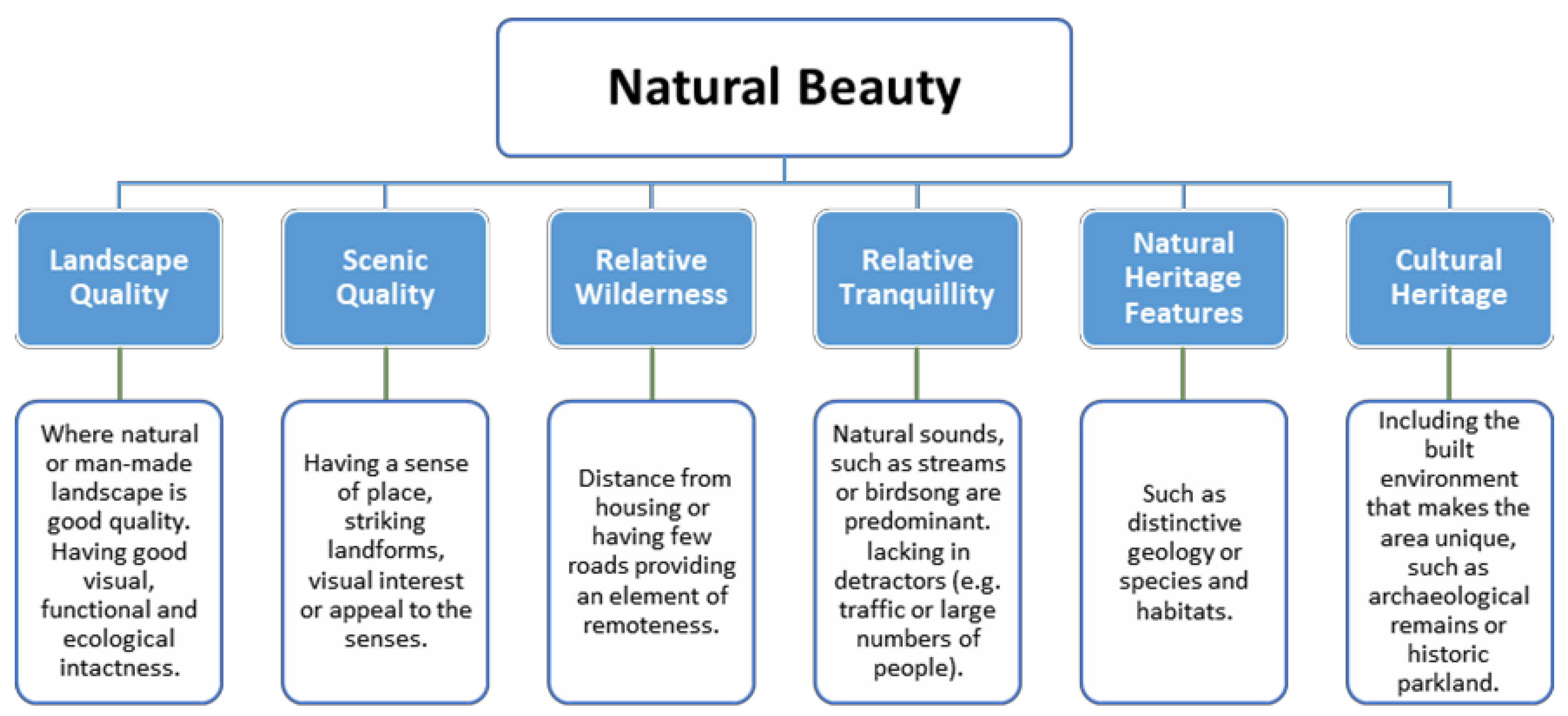
Areas of Outstanding Natural Beauty
2. Method
2.1. Case Study Areas
2.1.1. Arnside and Silverdale AONB
2.1.2. South Devon AONB
2.2. Online Questionnaire
2.3. Arnside and Silverdale AONB PGIS Survey
2.4. ‘What Makes South Devon Special?’ Survey
2.5. Instagram
2.6. Data Interpretation
3. Results
3.1. Online Questionnaire
3.2. Arnside and Silverdale PGIS
3.3. What Makes South Devon Special Survey
3.4. Instagram Uploads
4. Discussion
4.1. There Is No Significantly Preferred Landscape Component
4.2. The Same Area Can Be Differently Interpreted by Different People
4.3. Public Appreciation of Special Qualities
4.4. How the Results Reflect on AONB Effectiveness
4.5. Evaluation of Methodologies
4.6. Addressing Study Constraints in Future Research
5. Conclusions
Author Contributions
Funding
Institutional Review Board Statement
Informed Consent Statement
Data Availability Statement
Acknowledgments
Conflicts of Interest
References
- Defra. A Green Future: Our 25 Year Plan to Improve the Environment; HM Government: London, UK, 2018.
- Council of Europe. European Landscape Convention. European Treaty Series—No. 176; Council of Europe: Florence, Italy, 2000. [Google Scholar]
- Stephenson, J. The Cultural Values Model: An integrated approach to values in landscapes. Landsc. Urban Plan. 2008, 84, 127–139. [Google Scholar] [CrossRef]
- Oteros-Rozas, E.; Martin-Lopez, B.; Fagerholm, N.; Bieling, C.; Plieninger, T. Using social media photos to explore the relation between cultural ecosystem services and landscape features across five European sites. Ecol. Indic. 2018, 94, 74–86. [Google Scholar] [CrossRef]
- Dorning, M.A.; Van Berkel, D.B.; Semmens, D.J. Integrating Spatially Explicit Representations of Landscape Perceptions into Land Change Research. Curr. Landsc. Ecol. Rep. 2017, 2, 73–88. [Google Scholar] [CrossRef] [Green Version]
- Moore, T.; Tully, G. Connecting landscapes: Examining and enhancing the relationship between stakeholder values and cultural landscape management in England. Landsc. Res. 2017, 43, 769–783. [Google Scholar] [CrossRef] [Green Version]
- Loucks, O.; Kaplowitz, M.; Turnley, J.G.; McGee, B.; Dietz, T.; Stahl, R.; Kapustka, L.; Munns, W.; Bruins, R. Sociocultural Valuation Of Ecological Resources. In Valuation of Ecological Resources; CRC Press: Boca Raton, FL, USA, 2007; pp. 9–44. [Google Scholar]
- Daniel, T.C.; Muhar, A.; Arnberger, A.; Aznar, O.; Boyd, J.W.; Chan, K.M.; Costanza, R.; Elmqvist, T.; Flint, C.G.; Gobster, P.H.; et al. Contributions of cultural services to the ecosystem services agenda. Proc. Natl. Acad. Sci. USA 2012, 109, 8812–8819. [Google Scholar] [CrossRef] [PubMed] [Green Version]
- Millennium Ecosystem Assessment (MA). Ecosystems and Human Well-Being: Synthesis; Island Press: Washington, DC, USA, 2005. [Google Scholar]
- Fish, R.; Church, A.; Winter, M. Conceptualising cultural ecosystem services: A novel framework for research and critical engagement. Ecosyst. Serv. 2016, 21, 208–217. [Google Scholar] [CrossRef] [Green Version]
- Small, N.; Munday, M.; Durance, I. The challenge of valuing ecosystem services that have no material benefits. Glob. Environ. Chang. 2017, 44, 57–67. [Google Scholar] [CrossRef]
- Paracchini, M.; Zulian, G.; Kopperoinen, L.; Maes, J.; Schagner, J.; Termansen, M.; Zandersen, M.; Perez-Soba, M.; Scholefield, P.; Bidoglio, G. Mapping cultural ecosystem services: The case of outdoor recreation across the EU. Ecol. Indic. 2014, 45, 371–385. [Google Scholar] [CrossRef] [Green Version]
- Hølleland, H.; Skrede, J.; Holmgaard, S.B. Cultural Heritage and Ecosystem Services: A Literature Review. Conserv. Manag. Archaeol. Sites 2017, 19, 210–237. [Google Scholar] [CrossRef]
- Wartman, F.; Purves, R. Investigating sense of place as a cultural ecosystem service in different landscapes through the lens of language. Landsc. Urban Plan. 2018, 175, 169–183. [Google Scholar] [CrossRef]
- Wartmann, F.M.; Acheson, E.; Purves, R.S. Describing and comparing landscapes using tags, texts, and free lists: An interdisciplinary approach. Int. J. Geogr. Inf. Sci. 2018, 32, 1572–1592. [Google Scholar] [CrossRef] [Green Version]
- Tengberg, A.; Fredholm, S.; Eliasson, I.; Knez, I.; Saltzman, K.; Wetterberg, O. Cultural ecosystem services provided by landscapes: Assessment of heritage values and identity. Ecosyst. Serv. 2012, 2, 14–26. [Google Scholar] [CrossRef]
- LUC. The Value of AONB Partnerships: An Independent Assessment Prepared for AONB Partnerships; LUC: Bristol, UK, 2013. [Google Scholar]
- Gov.UK. Guidance: Areas of Outstanding Natural Beauty (AONBs): Designation and Management. 2018. Available online: https://www.gov.uk/guidance/areas-of-outstanding-natural-beauty-aonbs-designation-and-management (accessed on 10 September 2021).
- Ministry of Housing, Communities and Local Government. National Planning Policy Framework; Ministry of Housing, Communities and Local Government: London, UK, 2018.
- Defra. Areas of Outstanding Natural Beauty: Landscape Protection and Enhancement Support Scheme (England) 2017—19 Application to European Commission; Defra: London, UK, 2017.
- South Devon AONB Partnership. Management Plan 2014–2019; South Devon AONB Partnership: Totnes, UK, 2014. [Google Scholar]
- Alison Farmer Associates. Dedham Vale AONB Natural Beauty and Special Qualities and Perceived and Anticipated Risks: Final Report; Dedham Vale AONB: Dedham, UK, 2016; Available online: https://www.dedhamvalestourvalley.org/wp-content/uploads/2020/12/Dedham-Vale-Natural-Beauty-and-Spacial-Qualities-Final-Report-July-2016.pdf (accessed on 1 November 2021).
- Frank Fürst, C.; Koschke, L.; Witt, A.; Makeschin, F. Assessment of landscape aesthetics—Validation of a landscape metrics-based assessment by visual estimation of the scenic beauty. Ecol. Indic. 2013, 32, 222–231. [Google Scholar] [CrossRef]
- Daniel, T. Whither scenic beauty? Visual landscape quality assessment in the 21st century. Landsc. Urban Plan. 2001, 54, 267–281. [Google Scholar] [CrossRef]
- Selman, P.; Swanwick, C. On the Meaning of Natural Beauty in Landscape Legislation. Landsc. Res. 2010, 35, 3–26. [Google Scholar] [CrossRef] [Green Version]
- Brown, G.; Brabyn, L. An analysis of the relationships between multiple values and physical landscapes at a regional scale using public participation GIS and landscape character classification. Landsc. Urban Plan. 2012, 107, 317–331. [Google Scholar] [CrossRef]
- Tudor, C. An Approach to Landscape Character Assessment; Natural England: London, UK, 2014. Available online: https://assets.publishing.service.gov.uk/government/uploads/system/uploads/attachment_data/file/691184/landscape-character-assessment.pdf (accessed on 1 September 2021).
- English, R.; Tanner-Tremain, V.; Dixon, D. Planning for the South Devon AONB: Planning Guidance v1; South Devon AONB Partnership: Totnes, UK, 2017. [Google Scholar]
- CPRE. Beauty Betrayed: How Reckless Housing Development Threatens England’s AONBs; Campaign to Protect Rural England: London, UK, 2016. [Google Scholar]
- Arnside & Silverdale AONB. Arnside and Silverdale Area of Outstanding Natural Beauty: Statutory Management Plan 2014–2019; Arnside & Silverdale AONB Partnership: Carnforth, UK, 2014. [Google Scholar]
- Dixon, D.; Sinden, N.; Crabtree, T. An Independent Review of Housing in England’s Areas of Outstanding Natural Beauty 2012–2017. Landscapes for Life, CPRE, 2017. Available online: https://www.cpre.org.uk/wp-content/uploads/2019/11/An-independent-review-of-housing-in-Englands-AONBs-2012-17.pdf (accessed on 1 September 2021).
- Van Berkel, D.B.; Tabrizian, P.; Dorning, M.A.; Smart, L.; Newcomb, D.; Mehaffey, M.; Neale, A.; Meentemeyer, R. Quantifying the visual-sensory landscape qualities that contribute to cultural ecosystem services using social media and LiDAR. Ecosyst. Serv. 2018, 31, 326–335. [Google Scholar] [CrossRef] [PubMed]
- Zandersen, M.; Lindhjem, H.; Magnussen, K.; Helin, J.; Reinvang, R. Assessing Landscape Experiences as a Cultural Ecosystem Service in Public Infrastructure Projects: From Concept to Practice; Nordic Council of Ministers: Copenhagen, Denmark, 2017; Volume 510. [Google Scholar]
- UK National Ecosystem Assessment. The UK National Ecosystem Assessment: Synthesis of the Key Findings; UNEP-WCMC, LWEC: Cambridge, UK, 2014; Available online: https://www.unep-wcmc.org/resources-and-data/the-uk-national-ecosystem-assessment--synthesis-of-the-key-findings-and-technical-reports (accessed on 20 September 2021).
- Natural England, 2018. Natural England Open Data: Areas of Outstanding Natural Beauty (England). Available online: https://naturalengland-defra.opendata.arcgis.com/datasets/areas-of-outstanding-natural-beauty-england?geometry=-31.852%2C47.971%2C-2.672%2C57.264 (accessed on 1 November 2021).
- Arnside & Silverdale AONB. What Is Special about Arnside & Silverdale Area of Outstanding Natural Beauty? Arnside & Silverdale AONB, 2016. Available online: https://www.arnsidesilverdaleaonb.org.uk/wp-content/uploads/2016/11/ASAONB-Special-Qualities-Report-FINAL-1.pdf (accessed on 1 September 2021).
- Harrison, P.A.; Dunford, R.; Barton, D.N.; Kelemen, E.; Martin-Lopez, B.; Norton, L.; Termansen, M.; Saarikoski, H.; Hendriks, K.; Gómez-Baggethun, E.; et al. Selecting methods for ecosystem service assessment: A decision tree approach. Ecosyst. Serv. 2018, 29, 481–498. [Google Scholar] [CrossRef] [Green Version]
- Martín-López, M.; Iniesta-Arandia, I.; García-Llorente, M.; Palomo, I.; Casado-Arzuaga, I.; Del Amo, D.; Gómez-Baggethun, E.; Oteros-Rozas, E.; Palacios-Agundez, I.; Willaarts, B.; et al. Uncovering Ecosystem Service Bundles through Social Preferences. PLoS ONE 2012, 7, e38970. [Google Scholar] [CrossRef] [PubMed] [Green Version]
- Howley, P.; Donoghue, C.O.; Hynes, S. Exploring public preferences for traditional farming landscapes. Landsc. Urban Plan. 2012, 104, 66–74. [Google Scholar] [CrossRef]
- Brown, G.; Kyttä, M. Key issues and priorities in participatory mapping: Toward integration or increased specialization? Appl. Geogr. 2018, 95, 1–8. [Google Scholar] [CrossRef]
- Brown, G.G.; Reed, P. Social Landscape Metrics: Measures for Understanding Place Values from Public Participation Geographic Information Systems (PPGIS). Landsc. Res. 2012, 37, 73–90. [Google Scholar] [CrossRef]
- Tenkanen, H.; Di Minin, E.; Heikinheimo, V.; Hausmann, A.; Herbst, M.; Kajala, L.; Toivonen, T. Instagram, Flickr, or Twitter: Assessing the usability of social media data for visitor monitoring in protected areas. Sci. Rep. 2017, 7, 17615. [Google Scholar] [CrossRef] [Green Version]
- Grothe, C.; Schaab, J. Automated Footprint Generation from Geotags with Kernel Density Estimation and Support Vector Machines. Spat. Cogn. Comput. 2009, 9, 195–211. [Google Scholar] [CrossRef]
- Heikinheimo, V.; Di Minin, E.; Tenkanen, H.; Hausmann, A.; Erkkonen, J.; Toivonen, T. User-Generated Geographic Information for Visitor Monitoring in a National Park: A Comparison of Social Media Data and Visitor Survey. ISPRS Int. J. Geo-Inf. 2017, 6, 85. [Google Scholar] [CrossRef] [Green Version]
- Dandy, N.; Van Der Wal, R. Shared appreciation of woodland landscapes by land management professionals and lay people: An exploration through field-based interactive photo-elicitation. Landsc. Urban Plan. 2011, 102, 43–53. [Google Scholar] [CrossRef]
- Natural England. Experiencing Landscapes: Capturing the Cultural Services and Experiential Qualities of Landscape: Natural England Commissioned Report NECR024; Natural England: Cheltenham, UK, 2009.
- Herbst, H.; Förster, M.; Kleinschmit, B. Contribution of landscape metrics to the assessment of scenic quality—The example of the landscape structure plan Havelland/Germany. Landsc. Online 2009, 10, 1–17. [Google Scholar] [CrossRef]
- Duarte, G.T.; Santos, P.M.; Cornelissen, T.G.; Ribeiro, M.C.; Paglia, A.P. The effects of landscape patterns on ecosystem services: Meta-analyses of landscape services. Landsc. Ecol. 2018, 33, 1247–1257. [Google Scholar] [CrossRef] [Green Version]
- Ridding, L.; Redhead, J.; Oliver, T.; Schmucki, R.; McGinlay, J.; Graves, A.; Morris, J.; Bradbury, R.; King, H.; Bullock, J. The importance of landscape characteristics for the delivery of cultural ecosystem services. J. Environ. Manag. 2018, 206, 1145–1154. [Google Scholar] [CrossRef] [Green Version]
- Plieninger, T.; Dijks, S.; Oteros-Rozas, E.; Bieling, C. Assessing, mapping, and quantifying cultural ecosystem services at community level. Land Use Policy 2013, 33, 118–129. [Google Scholar] [CrossRef] [Green Version]
- Ala-Hulkko, T.; Kotavaara, O.; Alahuhta, J.; Helle, P.; Hjort, J. Introducing accessibility analysis in mapping cultural ecosystem services. Ecol. Indic. 2016, 66, 416–427. [Google Scholar] [CrossRef]
- CPRE, (n.d.). Campaign to Protect Rural England: Tranquil Places. Available online: https://www.cpre.org.uk/what-we-do/countryside/tranquil-places (accessed on 10 September 2021).
- Arnside & Silverdale AONB, (n.d.) Arnside & Silverdale AONB: Discover Wildlife. Available online: http://www.arnsidesilverdaleaonb.org.uk/discover/things-to-see-do/discover-wildlife/ (accessed on 1 September 2021).
- Hewlett, D.; Harding, L.; Munro, T.; Terradillos, A.; Wilkinson, K. Broadly engaging with tranquillity in protected landscapes: A matter of perspective identified in GIS. Landsc. Urban Plan. 2017, 158, 185–201. [Google Scholar] [CrossRef] [Green Version]
- Zoderer, B.M.; Tasser, E.; Erb, K.-H.; Stanghellini, P.S.L.; Tappeiner, U. Identifying and mapping the tourists perception of cultural ecosystem services: A case study from an Alpine region. Land Use Policy 2016, 56, 251–261. [Google Scholar] [CrossRef]
- van Zanten, B.T.; Zasada, I.; Koetse, M.; Ungaro, F.; Häfner, K.; Verburg, P. A comparative approach to assess the contribution of landscape features to aesthetic and recreational values in agricultural landscapes. Ecosyst. Serv. 2016, 17, 87–98. [Google Scholar] [CrossRef]
- Li, L.; Goodchild, M.F.; Xu, B. Spatial, temporal, and socioeconomic patterns in the use of Twitter and Flickr. Cartogr. Geogr. Inf. Sci. 2013, 40, 61–77. [Google Scholar] [CrossRef]
- Di Minin, E.; Tenkanen, H.; Toivonen, T. Prospects and challenges for social media data in conservation science. Front. Environ. Sci. 2015, 3, 63. [Google Scholar] [CrossRef] [Green Version]


| Code Name | Special Quality |
|---|---|
| ASSQ1 | Outstanding landscape and spectacular views. |
| ASSQ2 | Unique limestone geology. |
| ASSQ3 | A stunning seascape. |
| ASSQ4 | Rare and precious habitats. |
| ASSQ5 | Internationally and nationally important species. |
| ASSQ6 | Rich sense of history. |
| ASSQ7 | Distinctive settlement character. |
| ASSQ8 | Strong community and culture. |
| ASSQ9 | Opportunities to enjoy the countryside. |
| ASSQ10 | Sense of tranquillity, space and place. |
| ASSQ11 | A highly designated area. |
| Code Name | Special Quality |
|---|---|
| SDSQ1 | Fine, undeveloped, wild and rugged coastline. |
| SDSQ2 | Ria estuaries (drowned river valleys), steep combes and a network of associated watercourses. |
| SDSQ3 | Deeply rural rolling patchwork agricultural landscape. |
| SDSQ4 | Deeply incised landscape that is intimate, hidden and secretive away from the plateau tops. |
| SDSQ5 | Iconic wide, unspoilt and expansive panoramic views |
| SDSQ6 | A landscape with a rich time depth and a wealth of historic features and cultural associations. |
| SDSQ7 | A breadth and depth of significant habitats, species and associated natural events. |
| SDSQ8 | An ancient and intricate network of winding lanes, paths and recreational routes. |
| SQ9 | Areas of high tranquillity, natural nightscapes, distinctive natural soundscapes and visible movement. |
| SQ10 | A variety in the setting to the AONB formed by the marine environment, Plymouth City, market and coastal towns, rural South Hams and southern Dartmoor. |
Publisher’s Note: MDPI stays neutral with regard to jurisdictional claims in published maps and institutional affiliations. |
© 2021 by the authors. Licensee MDPI, Basel, Switzerland. This article is an open access article distributed under the terms and conditions of the Creative Commons Attribution (CC BY) license (https://creativecommons.org/licenses/by/4.0/).
Share and Cite
King, I.; Martin, J. Exploring Public Recognition and Perceived Cultural Value of the Special Qualities within English Areas of Outstanding Natural Beauty. Sustainability 2021, 13, 12178. https://doi.org/10.3390/su132112178
King I, Martin J. Exploring Public Recognition and Perceived Cultural Value of the Special Qualities within English Areas of Outstanding Natural Beauty. Sustainability. 2021; 13(21):12178. https://doi.org/10.3390/su132112178
Chicago/Turabian StyleKing, Isabelle, and John Martin. 2021. "Exploring Public Recognition and Perceived Cultural Value of the Special Qualities within English Areas of Outstanding Natural Beauty" Sustainability 13, no. 21: 12178. https://doi.org/10.3390/su132112178
APA StyleKing, I., & Martin, J. (2021). Exploring Public Recognition and Perceived Cultural Value of the Special Qualities within English Areas of Outstanding Natural Beauty. Sustainability, 13(21), 12178. https://doi.org/10.3390/su132112178