
Contribution of Earth Observation and Geospatial Information for Urban Planning of Historic Cities’ Centres: The Case Study of Nicosia, Cyprus


Abstract
:1. Introduction
2. Case Study
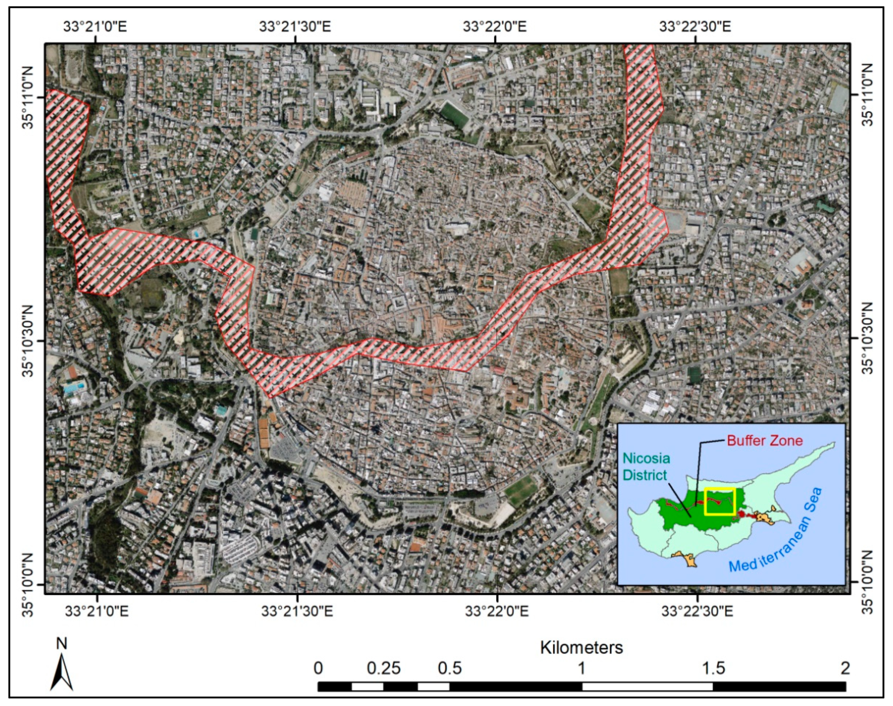
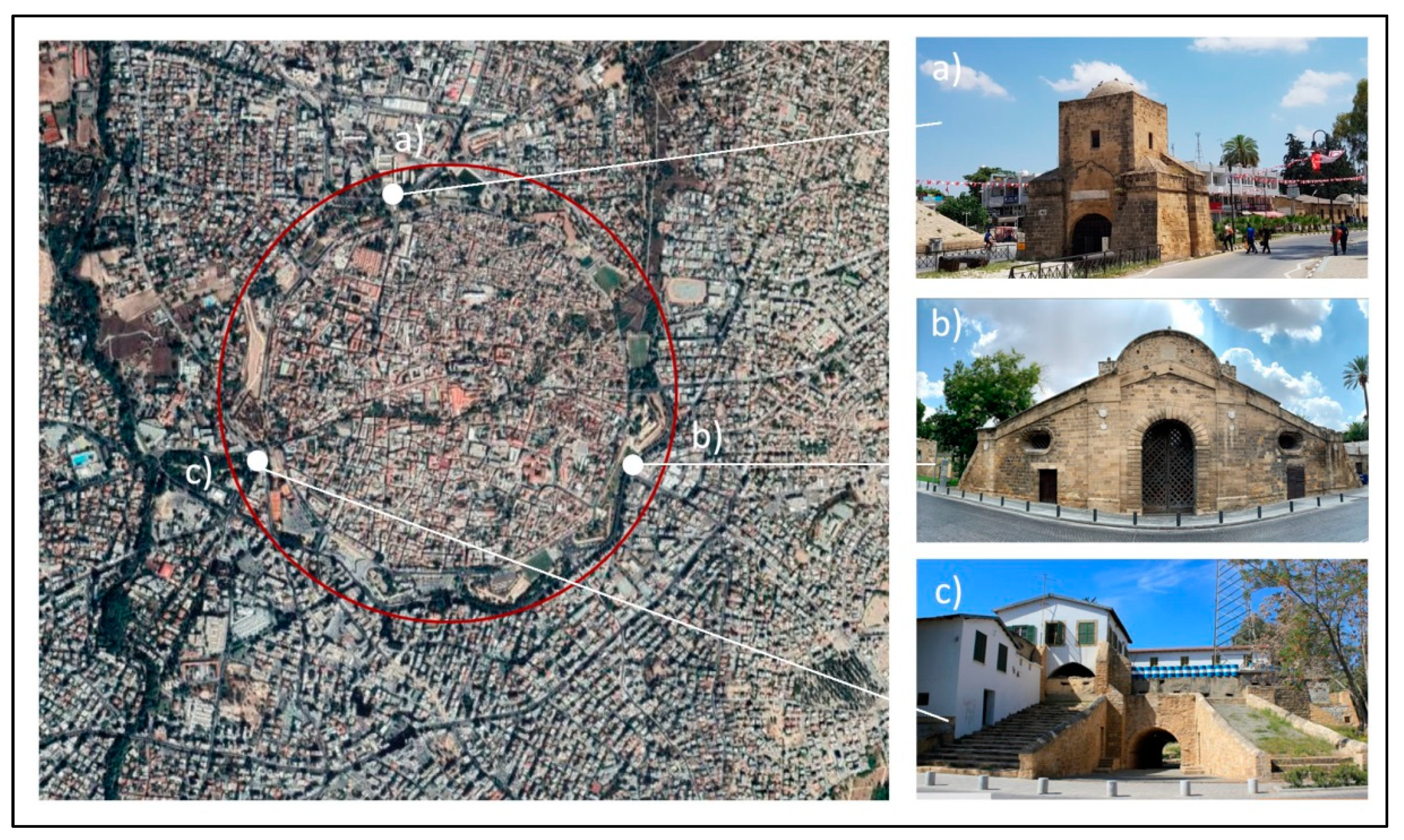
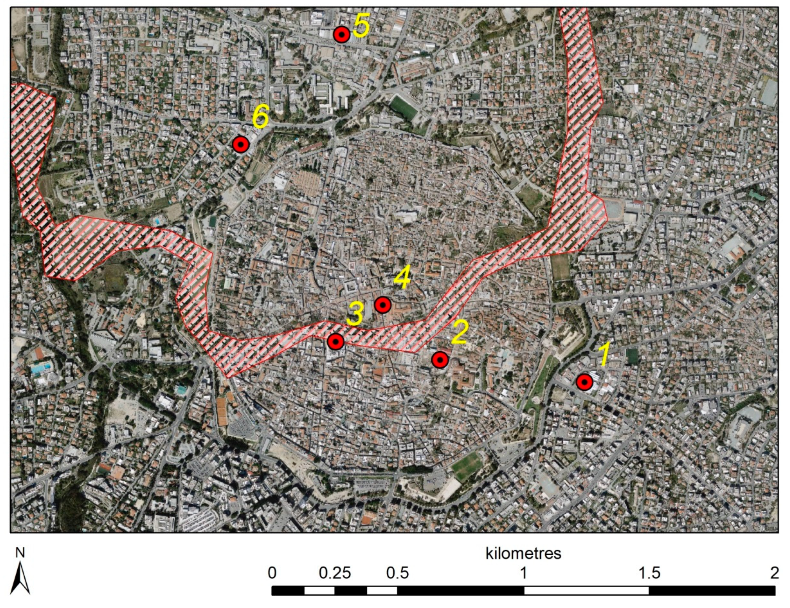
2.1. Nicosia Historic City Centre
2.2. National Spatial Data Infrastructures: Brief State of the Art in Cyprus
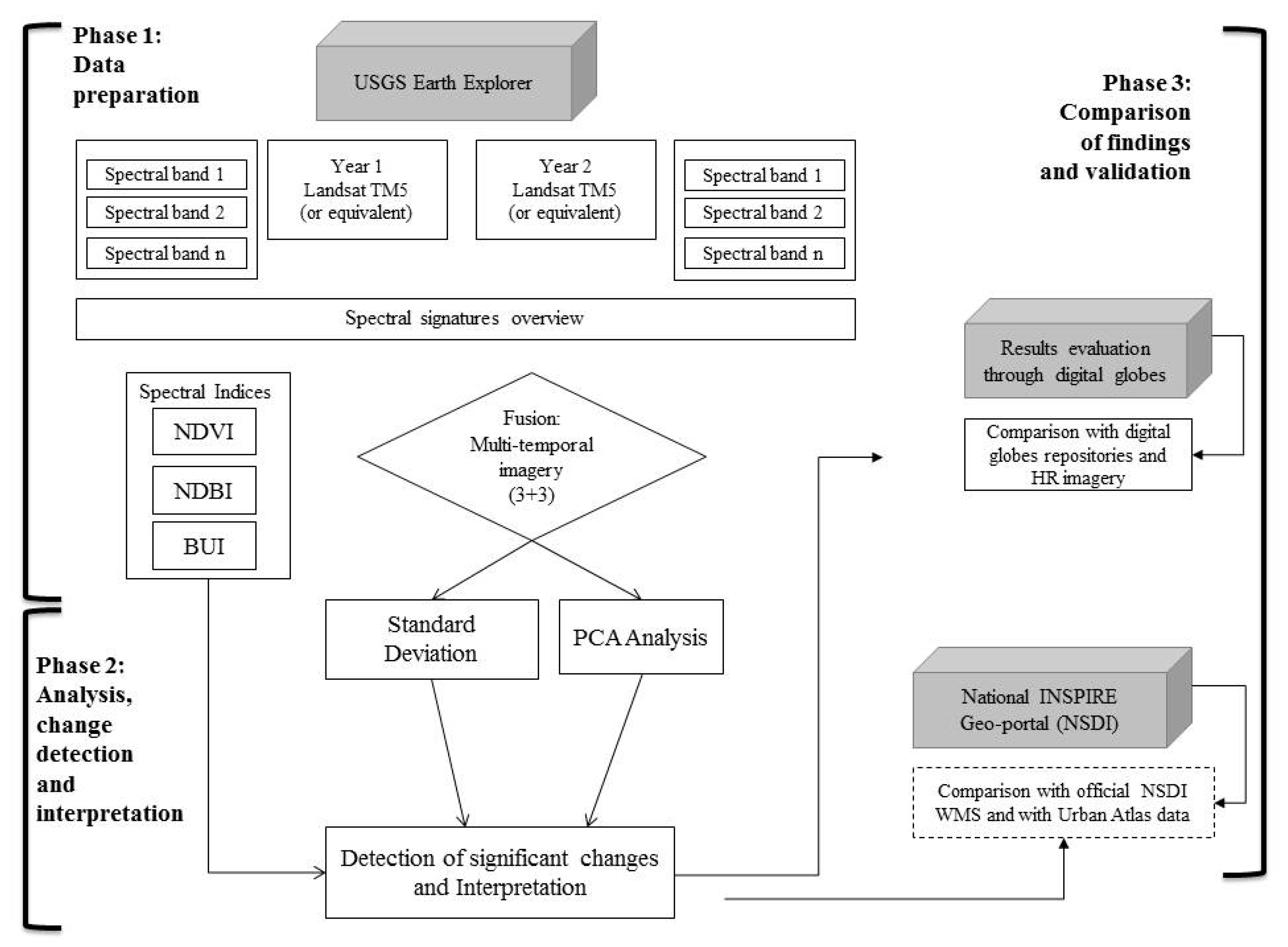
3. Datasets and Methodology
3.1. Data Selection Over Time Period 1984–2020
3.2. Methodology
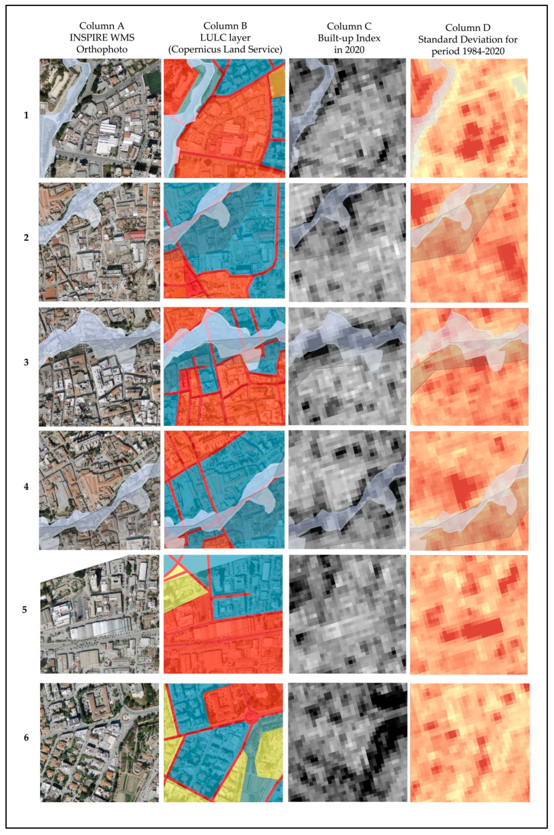
4. Results
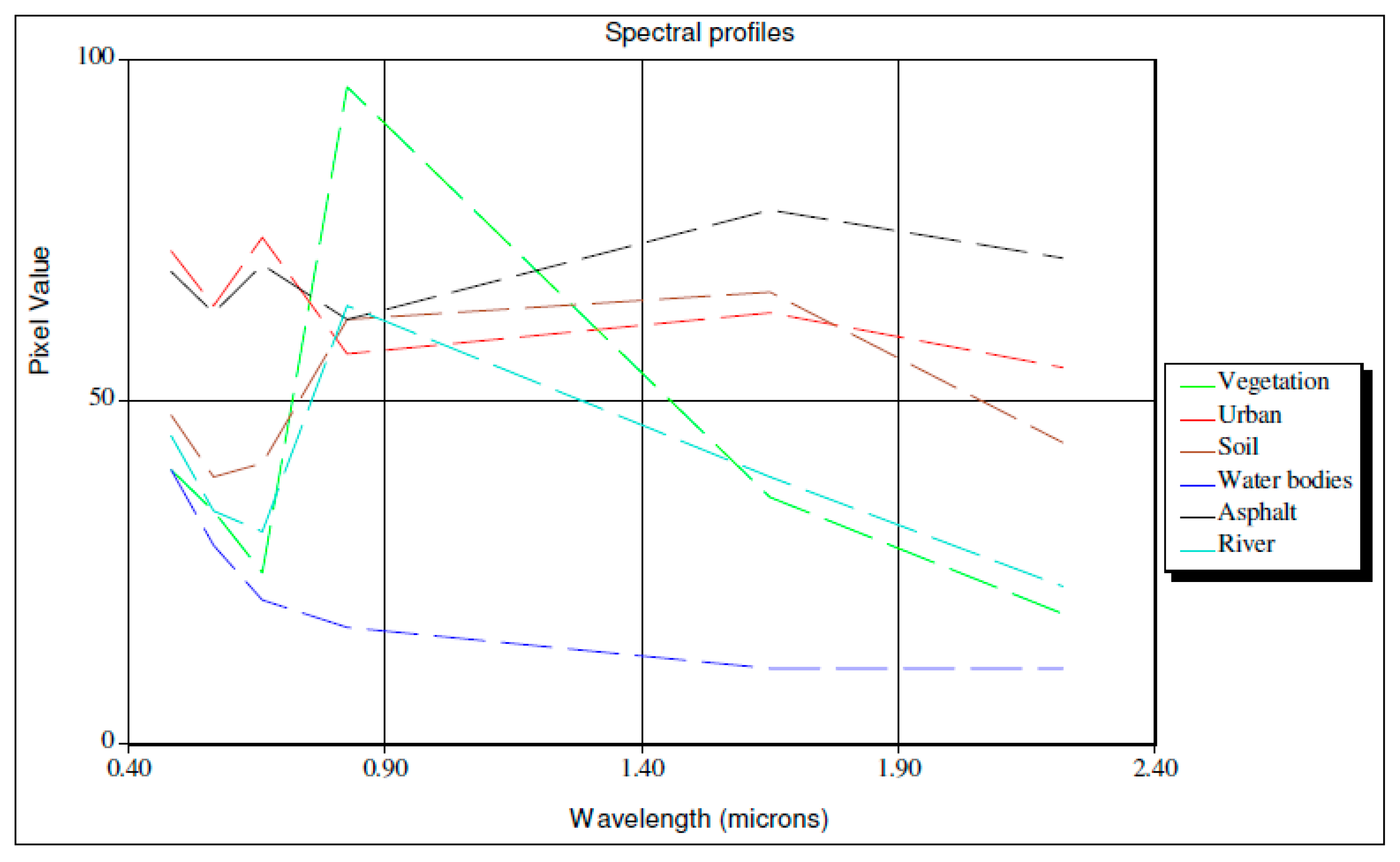
4.1. Spectral Signatures
4.2. Comparison of Indices Used for Enhancement of Built-Up Areas
4.3. Diachronic Spatial Analysis
4.3.1. Standard Deviation Analysis over the Year-Pairs
4.3.2. Principal Component Analysis (PCA) over the Year-Pairs
4.4. Comparisson of the Results with Openily Available Geo-Spatial Information
4.4.1. Evaluation of Results through HR Imagery and Digital Globes Repositories
4.4.2. Evaluation of Results Using Open Geospatial Data and NSDI Services
5. Discussion
6. Conclusions
- -
- The study was conducted using free, full and open (FFO) earth observation data (namely Landsat and Sentinel-2 multi-spectral optical imagery). Free distribution satellite imagery can foster a better uptake of such information for targeted solutions and applications;
- -
- The study detects and characterises some major morphological transformations within the walled city and around it. Main changes in the urban fabric were identified, underlining that significant changes occur in already dense urban areas and in a close proximity to an extremely well preserved cultural heritage monument i.e., Nicosia Venetian walls;
- -
- The limitation of this research involves the evaluation of changes that was only conducted visually on previously collected datasets. Further investigations could employ the use of spectro-radiometers for ground-truth data collection, satellite image calibration and elaboration of supervised classification products;
- -
- In terms of drawbacks, in order to process and interpret satellite imagery, high technical capacity is needed both in terms of software licences and processor capability as well as skilled personnel; these could often be the main weaknesses when not employing space-based data more systematically within public administration bodies;
- -
- The results were further been compared to (i) to high-resolution imagery, and digital globes repositories and (ii) specific layers provided as WMS by the NSDI. These last steps highlight how satellite-based products can easily be consulted within GIS environments by professionals with no compulsory prior knowledge of remote sensing data elaboration;
- -
- In addition, the results of this paper can be provided as WMS within existing geo-spatial repositories in order to integrate already freely available geospatial information provided by public administrations.
Author Contributions
Funding
Institutional Review Board Statement
Informed Consent Statement
Data Availability Statement
Acknowledgments
Conflicts of Interest
References
- United Nations: Sustainable Development Goals. Available online: https://www.un.org/sustainabledevelopment/cities/ (accessed on 30 April 2021).
- Tanrıkul, A.; Hoşkara, Ş. A New Framework for the Regeneration Process of Mediterranean Historic City Centres. Sustainability 2019, 11, 4483. [Google Scholar] [CrossRef] [Green Version]
- García-Hernández, M.; De la Calle-Vaquero, M.; Yubero, C. Cultural Heritage and Urban Tourism: Historic City Centres under Pressure. Sustainability 2017, 9, 1346. [Google Scholar] [CrossRef] [Green Version]
- Pellegrini, P.; Micelli, E. Paradoxes of the Italian Historic Centres between Underutilisation and Planning Policies for Sustainability. Sustainability 2019, 11, 2614. [Google Scholar] [CrossRef] [Green Version]
- Janssen, K.; Kuczerawy, A. Increasing the availability of spatial data held by public sector bodies: Some experiences and guidelines from the OneGeology-Europe Project. Int. J. Spat. Data Infrastruct. 2012, 7, 249–276. [Google Scholar]
- Georgiadou, Y.; Rodriguez-Pabón, O.; Lance, K.T. Spatial Data Infrastructure (SDI) and E-governance: A Quest For Appropriate Evaluation Approaches. URISA J. 2006, 18, 43–55. [Google Scholar]
- European Parliament. Directive 2007/2/EC of the European Parliament and of the Council of 14 March 2007 Establishing an Infrastructure for Spatial Information in the European Community (INSPIRE). 2007. Available online: https://eur-lex.europa.eu/legal-content/EN/TXT/?uri=CELEX%3A32007L0002&qid=1617356484780 (accessed on 30 April 2021).
- European Parliament. Directive (EU) 2019/1024 of the European Parliament and of the Council of 20 June 2019 on Open Data and the Re-Use of Public Sector Information (Open Data Directive). 2019. Available online: https://eur-lex.europa.eu/legal-content/EN/TXT/?qid=1561563110433&uri=CELEX:32019L1024 (accessed on 30 April 2021).
- European Parliament. Directive 2003/98/EC of the European Parliament and of the Council of 17 November 2003 on the re-use of public sector information. 2003. Available online: https://eur-lex.europa.eu/legal-content/en/ALL/?uri=CELEX:32003L0098 (accessed on 30 April 2021).
- Campagna, M.; Craglia, M. The socio-economic impact of the spatial data infrastructure of Lombardy. Environ. Plan. B Plan. Des. 2010, 39, 1069–1083. [Google Scholar] [CrossRef]
- Palafox-Juárez, E.B.; López-Martínez, J.O.; Hernández-Stefanoni, J.L.; Hernández-Nuñez, H. Impact of Urban Land-Cover Changes on the Spatial-Temporal Land Surface Temperature in a Tropical City of Mexico. ISPRS Int. J. Geo-Inf. 2021, 10, 76. [Google Scholar] [CrossRef]
- Moise, C.; Dana Negula, I.; Mihalache, C.E.; Lazar, A.M.; Dedulescu, A.L.; Rustoiu, G.T.; Inel, I.C.; Badea, A. Remote Sensing for Cultural Heritage Assessment and Monitoring: The Case Study of Alba Iulia. Sustainability 2021, 13, 1406. [Google Scholar] [CrossRef]
- Feng, D.; Bao, W.; Fu, M.; Zhang, M.; Sun, Y. Current and Future Land Use Characters of a National Central City in Eco-Fragile Region—A Case Study in Xi’an City Based on FLUS Model. Land 2021, 10, 286. [Google Scholar] [CrossRef]
- Wentz, E.A.; Anderson, S.; Fragkias, M.; Netzband, M.; Mesev, V.; Myint, S.W.; Quattrochi, D.; Rahman, A.; Seto, K.C. Supporting Global Environmental Change Research: A Review of Trends and Knowledge Gaps in Urban Remote Sensing. Remote Sens. 2014, 6, 3879–3905. [Google Scholar] [CrossRef] [Green Version]
- Ghazaryan, G.; Rienow, A.; Oldenburg, C.; Thonfeld, F.; Trampnau, B.; Sticksel, S.; Jürgens, C. Monitoring of Urban Sprawl and Densification Processes in Western Germany in the Light of SDG Indicator 11.3.1 Based on an Automated Retrospective Classification Approach. Remote Sens. 2021, 13, 1694. [Google Scholar] [CrossRef]
- Firozjaei, M.K.; Fathololoumi, S.; Mijani, N.; Kiavarz, M.; Qureshi, S.; Homaee, M.; Alavipanah, S.K. Evaluating the Spectral Indices Efficiency to Quantify Daytime Surface Anthropogenic Heat Island Intensity: An Intercontinental Methodology. Remote Sens. 2020, 12, 2854. [Google Scholar] [CrossRef]
- Banzhaf, E.; Wu, W.; Luo, X.; Knopp, J. Integrated Mapping of Spatial Urban Dynamics—A European-Chinese Exploration. Part 1—Methodology for Automatic Land Cover Classification Tailored towards Spatial Allocation of Ecosystem Services Features. Remote Sens. 2021, 13, 1744. [Google Scholar] [CrossRef]
- Ettehadi Osgouei, P.; Kaya, S.; Sertel, E.; Alganci, U. Separating Built-Up Areas from Bare Land in Mediterranean Cities Using Sentinel-2A Imagery. Remote Sens. 2019, 11, 345. [Google Scholar] [CrossRef] [Green Version]
- Marchesi, P. Fortezze Veneziane (1508–1797), 1st ed.; Rusconi Libri: Milan, Italy, 1984; pp. 84–93. [Google Scholar]
- UNFICYP. About the Buffer Zone. Available online: https://unficyp.unmissions.org/about-buffer-zone (accessed on 5 April 2021).
- Spatial Data Infrastructures in Cyprus: State of Play 2011. Available online: https://inspire.ec.europa.eu/reports/stateofplay2011/rcr11CYv120.pdf (accessed on 5 April 2021).
- INSPIRE in Your Country, Cyprus Country Fiche 2020. Available online: https://inspire.ec.europa.eu/sites/default/files/inspire_-_cyprus_-_2020_country_fiche.pdf (accessed on 30 April 2021).
- Geospatial Information Portal of Cyprus. Available online: http://www.geoportal.gov.cy/MOI/DLS/geoportal/geoportal.nsf/index_en/index_en?OpenDocument (accessed on 30 April 2021).
- Ji, W.; Ma, J.; Twibell, R.W.; Underhill, K. Characterising urban sprawl using multi-stage remote sensing images and landscape metrics. Comput. Environ. Urban Syst. 2006, 30, 861–879. [Google Scholar] [CrossRef]
- Bhatta, B. Remote Sensing, GIS, and Urban Analysis. In Analysis of Urban Growth and Sprawl from Remote Sensing Data; Advances in Geographic Information Science; Springer: Berlin/Heidelberg, Germany, 2010; pp. 49–63. [Google Scholar] [CrossRef]
- El Garouani, A.; Mulla, D.J.; El Garouani, S.; Knight, J. Analysis of urban growth and sprawl from remote sensing data: Case of Fez, Morocco. Int. J. Sustain. Built. Environ. 2017, 6, 160–169. [Google Scholar] [CrossRef]
- Agapiou, A.; Alexakis, D.D.; Lysandrou, V.; Sarris, A.; Cuca, B.; Themistocleous, K.; Hadjimitsis, D.G. Impact of Urban Sprawl to archaeological research: The case study of Paphos area in Cyprus. J. Cult. Herit. 2015, 16, 671–680. [Google Scholar] [CrossRef]
- United States Geological Survey (USGS). Earth Explorer Service. Available online: https://earthexplorer.usgs.gov/ (accessed on 2 April 2021).
- Du, P.; Li, X.; Cao, W.; Luo, Y.; Zhang, H. Monitoring urban land cover and vegetation change by multi-temporal remote sensing information. Min. Sci. Technol. (China) 2010, 20, 922–932. [Google Scholar] [CrossRef]
- Polydoros, A.; Cartalis, C. Assessing the impact of urban expansion to the state of thermal environment of peri-urban areas using indices. Urban Clim. 2015, 14, 166–175. [Google Scholar] [CrossRef]
- Zha, Y.; Gao, J.; Ni, S. Use of normalized difference built-up index in automatically mapping urban areas from TM imagery. Int. J. Remote Sens. 2003, 24, 583–594. [Google Scholar] [CrossRef]
- He, C.; Shi, P.; Xie, D.; Zhao, Y. Improving the normalized difference built-up index to map urban built-up areas using a semiautomatic segmentation approach. Remote Sens. Lett. 2010, 1, 213–221. [Google Scholar] [CrossRef] [Green Version]
- Kadhim, N.; Mourshed, M.; Bray, M. Advances in remote sensing applications for urban sustainability. Euro-Mediterr. J. Environ. Integr. 2016, 1, 7. [Google Scholar] [CrossRef] [Green Version]
- Cuca, B. Evaluation of Changes in the City Fabric Using Multispectral Multi-temporal Geospatial Data: Case Study of Milan, Italy. In International Conference on Computational Science and Its Applications; Lecture Notes in Computer Science; Springer: Cham, Switzerland, 2020; Volume 12252, pp. 813–828. [Google Scholar] [CrossRef]
- European Parliament. Directive 2007/60/EC of the European Parliament and of the Council of 23 October 2007 on the Assessment and Management of Flood Risks. 2007. Available online: https://eur-lex.europa.eu/legal-content/EN/TXT/?uri=celex:32007L0060 (accessed on 30 April 2021).
- Kukulska-Kozieł, A.; Szylar, M.; Cegielska, K.; Noszczyk, T.; Hernik, J.; Gawroński, K.; Dixon-Gough, R.; Jombach, S.; Valánszki, I.; Kovács, K.F. Towards three decades of spatial development transformation in two contrasting post-Soviet cities—Kraków and Budapest. Land Use Policy 2019, 85, 328–339. [Google Scholar] [CrossRef]
- Kowe, P.; Mutanga, O.; Dube, T. Advancements in the remote sensing of landscape pattern of urban green spaces and vegetation fragmentation. Int. J. Remote Sens. 2021, 42, 3797–3832. [Google Scholar] [CrossRef]
- Salata, S. The Utilization of Supervised Classification Sampling for Environmental Monitoring in Turin (Italy). Sustainability 2021, 13, 2494. [Google Scholar] [CrossRef]
- Empler, T. La rappresentazione del paesaggio: Dal sincronico al diacronico. In Il Prossimo Paesaggio; Banconi, F., Filippucci, M., Eds.; Gangemi Editore Spa: Rome, Italy, 2018; pp. 45–50. [Google Scholar]
- UNESCO. World Heritage and Buffer Zones; World Heritage Papers (25); Martin, O., Piatti, G., Eds.; UNESCO World Heritage Centre: Paris, France, 2009; Available online: https://whc.unesco.org/en/series/25/ (accessed on 16 June 2021).
- UNESCO World Heritage List, The Venetian Works of Defence between 15th and 17th Centuries (Italy, Croatia, Montenegro). Available online: https://whc.unesco.org/en/list/1533/ (accessed on 16 June 2021).


| Year (Month-Date) | Image Type (Sensor) | Spatial Resolution in VIS/NIR | Spatial Resolution in SWIR | Spectral Resolution (μm) (Listed only Green-NIR-SWIR) |
|---|---|---|---|---|
| 15 May 1984 | Landsat-5 | 30 m | 30 m | Green: 0.52–0.60 NIR: 0.76–0.90 SWIR: 2.08–2.35 |
| 12 June 2000 | Landsat-5 | 30 m | 30 m | Green: 0.52–0.60 NIR: 0.76–0.90 SWIR: 2.08–2.35 |
| 18 May 2020 | Sentinel-2A | 10 m | 20 m | Green: 0.56 NIR: 0.83 SWIR: 2.20 |
| Index Name | Index ID | Bands Used | Formula | Application | Reference |
|---|---|---|---|---|---|
| Normalised difference vegetation index | NDVI | NIR and Red | Mapping urban land cover and vegetation change | [29] | |
| Normalised difference built-up index | NDBI | SWIR and NIR | Automatically mapping urban areas | [31] | |
| Built-up index | BUI | SWIR, NIR and RED | NDBI−NDVI | Mapping urban built-up areas | [32] |
| Point | 2001 | 2011–2013 | 2020 |
|---|---|---|---|
| 1 |  |  |  |
| 2 |  | 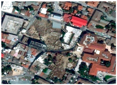 | 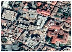 |
| 3 | 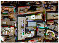 |  | 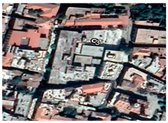 |
| 4 | 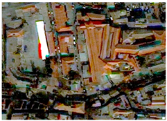 |  |  |
| 5 |  | 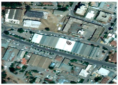 |  |
| 6 | 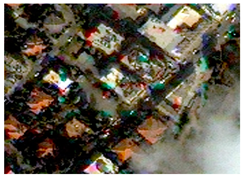 |  |  |
| Type of Data/Theme Name | Type of Access | Source | Year of Reference |
|---|---|---|---|
| Urban Atlas layer | Open geospatial data (download upon request as a registered user) | Copernicus Land Monitoring service | 2012 |
| Orthoimagery (INSPIRE theme, DLS) | Web Map Service | NSDI * | 2014 |
| Natural risks zones (INSPIRE theme; Water development Department) | Web Map Service | NSDI * | 2015 |
| Hydrography (INSPIRE theme; Water development Department) | Web Map Service | NSDI * | 2015 |
Publisher’s Note: MDPI stays neutral with regard to jurisdictional claims in published maps and institutional affiliations. |
© 2021 by the authors. Licensee MDPI, Basel, Switzerland. This article is an open access article distributed under the terms and conditions of the Creative Commons Attribution (CC BY) license (https://creativecommons.org/licenses/by/4.0/).
Share and Cite
Cuca, B.; Agapiou, A. Contribution of Earth Observation and Geospatial Information for Urban Planning of Historic Cities’ Centres: The Case Study of Nicosia, Cyprus. Sustainability 2021, 13, 7023. https://doi.org/10.3390/su13137023
Cuca B, Agapiou A. Contribution of Earth Observation and Geospatial Information for Urban Planning of Historic Cities’ Centres: The Case Study of Nicosia, Cyprus. Sustainability. 2021; 13(13):7023. https://doi.org/10.3390/su13137023
Chicago/Turabian StyleCuca, Branka, and Athos Agapiou. 2021. "Contribution of Earth Observation and Geospatial Information for Urban Planning of Historic Cities’ Centres: The Case Study of Nicosia, Cyprus" Sustainability 13, no. 13: 7023. https://doi.org/10.3390/su13137023
APA StyleCuca, B., & Agapiou, A. (2021). Contribution of Earth Observation and Geospatial Information for Urban Planning of Historic Cities’ Centres: The Case Study of Nicosia, Cyprus. Sustainability, 13(13), 7023. https://doi.org/10.3390/su13137023