1. Introduction
The multifunctional role of agricultural heritage systems is today widely recognized, and it refers to different sectors including the preservation of traditional landscapes characterized by great aesthetic and cultural significance, traditional agricultural practices, family farming and production of high quality food, protection from hydrogeological risk, connection to climate change, conservation of agrobiodiversity and soil, and resources for tourism [
1].
Despite the great importance of historical terraced landscapes, they represent a big challenge for conservation and management [
2,
3], mostly because these heritage systems have largely been abandoned all over the world, especially in Europe [
4,
5,
6,
7]. At the international level, programs such as the Globally Important Agricultural Heritage Systems (GIAHS), launched by the Food and Agriculture Organization (FAO), is of particular interest as regards traditional landscapes, as it is firmly connected to the different topics listed previously and to the concepts of multifunctionality and dynamic conservation [
8].
The preservation of agricultural heritage systems of great aesthetic and cultural significance, and of the associated traditional agricultural practices, is therefore fundamental for different reasons. The first one is the production of high quality food as well as the role of small farmers. Usually, traditional landscapes are characterized by small proprietorships or family farming, and the attachment that local communities show for their territories and traditions is fundamental, both in the preservation of these landscapes and for shaping local identity [
9,
10]. Traditional agricultural practices in the Mediterranean areas are also characterized by high energy and nutritional efficiency, and by the adaptation of production cycles to the natural ones according to local environmental conditions [
11]. The outcome of traditional practices, especially traditional cultivations, is the production of high quality products, which is greatly appreciated by consumers who are ready to pay a higher price for higher quality products that preserve a tight connection with the territory they come from. This added value, made up of aesthetics, knowledge, history, culture, and traditions, cannot be reproduced by other competitors, and it therefore becomes a central element on which it is necessary to focus in order to keep traditional landscapes productive, vital, and profitable [
12,
13]. If this is not done, these landscapes are doomed to disappear, as has happened to many cultural landscapes throughout Europe because agricultural production was no longer economically viable, especially in terraced landscapes [
14]. Therefore, landscape certification, being similar to other types of certifications, would allow the strengthening of the relationship between the quality of the product and the quality of the landscape [
15].
One of the most widespread type of agricultural heritage systems in the Mediterranean basin is the one related to terraced systems, and it is of great importance for its multifunctional role. The reduction of hydrogeological risk and soil conservation are probably the main ecosystem services provided by this system because terraced historical landscapes represent agricultural systems that shape steep slopes and strongly modify runoff and soil erosion processes [
16,
17,
18,
19,
20,
21,
22,
23,
24,
25].
Traditional terraced landscapes are also strictly connected to agrobiodiversity and biocultural diversity conservation [
26], which are two important concepts related to international initiatives. Agrobiodiversity is defined by the FAO, inside the GIAHS program, as “the variety of animals, plants, and micro-organisms that are used directly or indirectly for food and agriculture, including crops, livestock, forestry, and fisheries. It comprises the diversity of genetic resources (varieties and breeds) and species used for food, fodder, fiber, fuel, and pharmaceuticals. It also includes the diversity of non-harvested species that support production (soil micro-organisms, predators, and pollinators) and those in the wider environment that support agro-ecosystems (agricultural, pastoral, forest, and aquatic) as well as the diversity of the agro-ecosystems” (
http://www.fao.org/fileadmin/templates/giahs_assets/GIAHS_test/04_Become_a_GIAHS/02_Features_and_criteria/Criteria_and_Action_Plan_for_home_page_for_Home_Page_Jan_1_2017.pdf). The concept of cultural biodiversity is the subject of a joint program between UNESCO and the Convention on Biological Diversity [
27]. In 2014, these two entities released a common declaration (Florence Declaration) stating that “the European landscape is mainly a biocultural multifunctional landscape, since it is the result of historical and on-going processes that involve environment, land uses, and cultural heritage” and that “landscapes rich in biocultural diversity are often those resulting from small-scale farmers and traditional practices” [
28]. Finally, it is important to remember that the importance of dry-stone walls is also testified by the inclusion in 2018 of the “Art of dry-stone walling, knowledge, and techniques” in the UNESCO Intangible Heritage List.
Moreover, historical terraced landscapes can represent an important element of attractiveness for rural areas that are important touristic destinations, in Europe as well as in the rest of the world [
29]. In fact, rural tourism is often an alternative and economic diversification, capable of guaranteeing a higher income to the local population than sole traditional agricultural and pastoral activities [
30,
31,
32]. This is particularly true for Tuscany because the number of occupancies in farmhouses has continuously increased in the last few decades and, in 2018, a +9.4% increase in occupancies was registered, compared to 2017 [
33].
At the national level, it is important to remember that the recent institutional initiatives taken by the Italian Ministry of Agricultural Policies follow the concept of multifunctionality and promote traditional rural landscapes. In particular, in 2012, the Ministry established the National Register of Historical Rural Landscapes and Traditional Agricultural Practices, with the aim of identifying and cataloguing traditional rural landscapes or landscapes of historical interest connected to traditional practices and knowledges, where farmers play the central role of landscape managers. Moreover, recent modifications to the National Forest Law 227 of 2001, allows the restoration of previously cultivated land that has been colonized by shrubs or forests after its abandonment [
34].
The study area is located in Lamole, a village in Chianti (Tuscany, Italy) that perfectly represents the multifunctional role of historical landscapes. Here, the landscape is characterized by the alternation of forest and agricultural areas, which are often terraced; in fact, in the past, the relationship between agriculture and forests was particularly important. Chianti is well known for the quality of its products and as an international destination for rural tourism. In Lamole, the historical landscape is particularly well preserved and it has also been restored by local farmers in recent years. The quality of its landscape was also testified by its inclusion in the National Register of Historical Rural Landscapes in 2018.
The main aim of the research is to investigate if the tourists are aware of the peculiar characteristics of the historic landscape of Lamole or if it looks similar to the landscape of other parts of Chianti where the traditional landscape has undergone many changes, mostly due to the spread of large vine monocultures. How do tourists perceive the landscape in Lamole? Do they recognize the historical features as something peculiar? What are they looking for? Furthermore, there is an interest to analyze the main landscape changes in an area that is today considered as a good example of historical landscape features maintenance thanks to national ministerial programs. In fact, public participation and perception in landscape planning and management has received increased attention across Europe since the European Landscape Convention (ELC) came into force [
35]. Moreover, for those who study landscape transformations, it is an effective tool for verifying the relationship between scientific research and the views and needs of local populations and tourists [
36,
37]. With this in mind, the results could be of particular interest for local planning policies because they have to deal with touristic flow management, and for local farmers because a large part of their income comes from tourists as they offer accommodation, direct sales, and the tastings of local products.
2. Materials and Methods
2.1. The Study Area
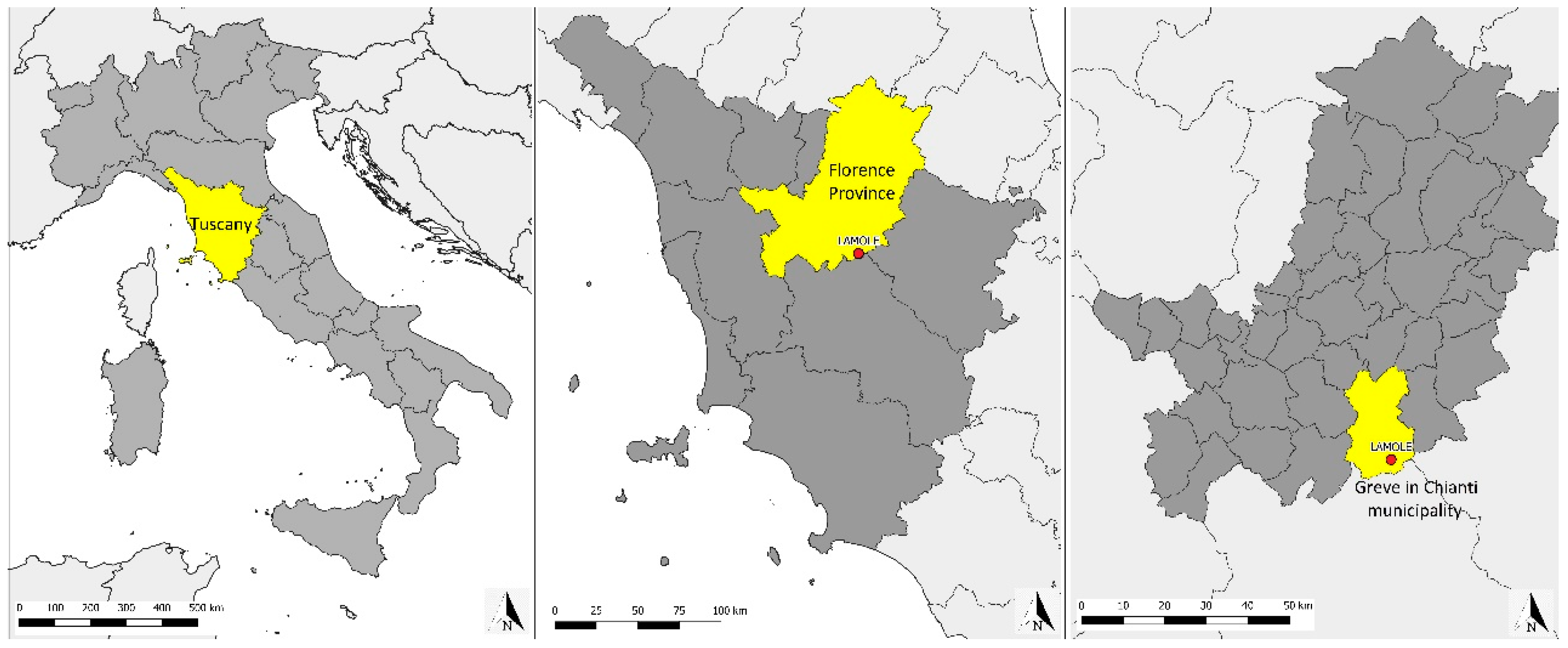
The study area of Lamole covers an area of about 710 hectares in the municipality of Greve in Chianti, between the cities of Florence and Siena (
Figure 1). The traditional landscape has been preserved, despite some minor unavoidable changes, and it is presently characterized by the presence of terraced vineyards around the villages, interrupted by small woods and olive orchards, and wooded areas in the outermost parts of the site. The land is privately owned. The geological substratum is formed of lorbiditic quartziferous-feldspathic sandstone with calcite, phyllosilicate, and silt schist. In the southern area is yellowish marl from the Oligocene. The fact that its historical landscape is considered of particular interest is testified by the inclusion of Lamole in the National Register of Historical Rural Landscapes, which was established in 2012 by the Italian Ministry for Agricultural Policies. In Lamole, traditional high-quality wines and olive oil are produced and are recognized by official labels such as the Controlled Designation of Origin (DOC) or the Controlled and Guaranteed Designation of Origin (DOCG) for Chianti wines, and the Protected Designation of Origin (PDO) for olive oil.
The origin of the name Lamole is uncertain. It apparently derives from the Latin word
lamulae, meaning “small blades” or “strips of earth”. In 1835, Emanuele Repetti wrote in his
Dizionario geografico fisico storico della Toscana that Lamole “lies on the northern slope of the Poggio delle Stinche” and “the vineyards that yield the good and much praised wine of Lamole are planted among the rocks of this hill” [
38], attesting that Lamole was already known for its wine quality.
Differently to other parts of Chianti, here the cultivation is still mainly carried out by smallholder farmers, who have also founded an association (I profumi di Lamole) to promote the territory and their products. In fact, tourism is a major resource of income for local farmers, and Lamole is in the heart of one of the most important areas for rural tourism in Italy (Chianti). Official numbers referring to the overall municipality of Greve in Chianti can give an idea of how tourism is locally important. According to the National Statistical Agency of 2017, there are 1286 beds available for tourists in farmhouses (51.5% of the total number), distributed in 81 farmhouses. According to the official data of the Tuscan Region relating to 2017, the Municipality of Greve in Chianti has 13,886 residents, and the number of total arrivals (tourists registered in the accommodation facilities, i.e., they have spent at least one night in Greve) is equal to 50,051 (81.6% of which are foreigners). From these numbers, without considering day-trips, it is clear that tourism is a very important resource for the local economy, particularly for farmers.
However, this territory also suffered depopulation after WWII, when local farmers abandoned cultivations and silvicultural activities and moved to the cities to find better life conditions and more work opportunities. In the 1970s, when the wine market modernized and demand for high quality Italian wines increased, many traditional cultivations were replaced by big vines monocultures, removing dry-stone terraces and planting rows of vines uphill. The removal of terraces and forest cultivation abandonment have increased soil erosion and landslides so that the hydrogeological risk is a significant issue today. According to the data of the official National Landslides Inventory, 7.7% of the entire Chianti territory is affected by landslides. This percentage rises to 12% if we consider only the vineyards and to 11% if we consider only the olive groves (National Landslides Inventory). According to research carried out in Chianti, soil erosion in the period 1954–1976 has increased by 900%, and in the uphill vineyards can reach up to 230 t/ha, while values normally considered acceptable are between 2 and 12 t/ha [
39].
In Lamole, the removal of terraces has been of little importance thanks to the particular location, which is far from the main roads, and to the morphology of the area because here the slopes are steeper than in the rest of Chianti so that planting vineyards uphill was not always possible. Furthermore, in the last few decades, the local farmers who have repopulated Lamole after their families left the area have noticed that preserving the historical terraced landscape gives an added value to this territory because it increases the quality of the wines. This is possible thanks to the orientation of the slopes because rows of vines planted on terraces are oriented from north to south so they are exposed for more hours to the rays of the setting sun without shadowing one another because they are planted at different levels. This is good for the sugar content of the grapes. Moreover, the stones of the terraces store the heat of the sun during the day and release it in the evening, creating a perfect microclimate for grapes maturation [
40]. For these reasons, local farmers, mostly thanks to their own funds and sometimes by applying for specific rural development funds, started to restore the old dry-stone terraces because they believed they were important, both for the quality of the product and for the quality and attractiveness of the landscape [
41].
2.2. Methodology
The methodology carried out in this research can be divided into two different phases.
The first one regards the study of the landscape changes, using GIS software to analyze both the landscape in 1832 and the current one in order to identify the historical landscape features and check the levels of its maintenance. The methodology adopted is multitemporal analysis and, in particular, VASA methodology (Historical and Cultural Evaluation Approach) [
42] that is also adopted by the National Register of Historical Landscapes to evaluate landscape changes and to assess the historical landscapes integrity.
The historical landscape has been assessed through analysis of the Catasto Generale della Toscana (General Cadaster of Tuscany), a complete survey of all Tuscan properties, published in 1832, that describes in detail the land use of each parcel. Thanks to this cadaster, it is possible to deeply study the historical landscape structure and produce land use maps. The cadaster maps are available through the WMS (Web Map Service) of the Tuscan Region, while the cadastral registers consulted to identify the land use of each parcel are kept at the State Archives in Florence. The 2016 landscape structure was studied through the photointerpretation of high-resolution ortophotos (20 cm), which are available in the WMS service of the Tuscan Region, and through field surveys that validated the results of the photointerpretation. After producing maps and databases for 1832 and 2016, these datasets were intersected using GIS software to obtain a new dataset, called a map of the dynamics, in which each polygon (patch) is classified according to a standard classification based on both the previous and the actual macrocathegory of land use, which are:
Anthropization: replacement of natural or semi-natural land use with urban areas, infrastructures, buildings, ect.;
Forestation: replacement of cultivations or pastures with woodlands or shrublands;
Deforestation: removal of woodlands or shrublands;
Intensification: replacement of low energy input land uses with land uses characterized by higher energy needs (e.g., traditional cultivation, specialized cultivations);
Extensification: replacement of high energy input land uses with land uses characterized by lower energy needs (e.g., cultivations, fallow lands);
Unchanged: the patches retain the same macrocathegory of land use (e.g., perennial cultivations, forests, or shrublands).
The historical landscape and landscape changes study covering the last 184 years has allowed both the identification of peculiar features and the comprehension of the level of their maintenance.
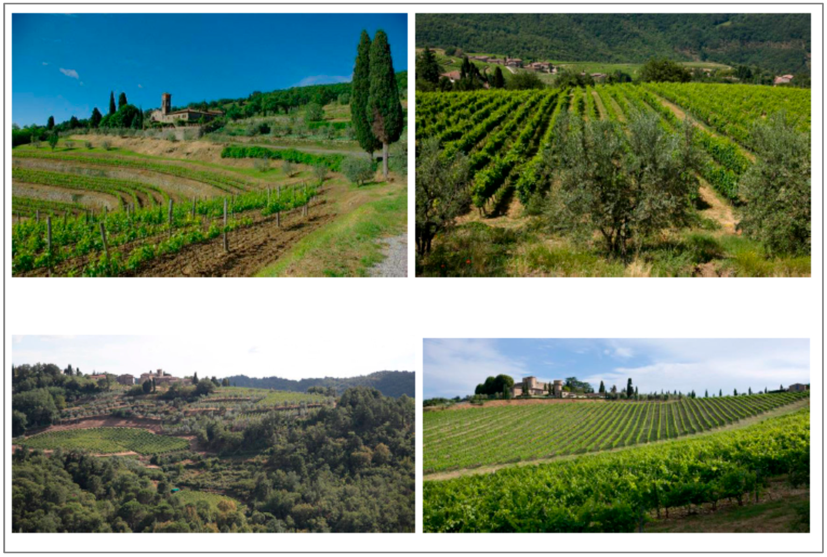
The second phase of the research focused on the landscape perception analysis among tourists using anonymous questionnaires, structured in a total of 13 multiple choices questions and divided into two parts. The first part concerned general information, including age range, gender, educational level, country of origin, and occupation. The second part concerned their experience in Lamole and in Chianti and their landscape perception, with questions about the number of days spent in the area, whether this was their first time in Chianti, and their views on the role of dry-stone terraces. Respondents were also asked to assign a value from 1 to 5 (1 minimum and 5 maximum) to different land uses according to their importance for the landscape. The questionnaire then considers a question concerning the role of public institutions (municipality, province, region), in particular about the services for tourists that could be improved. Finally, participants were asked to indicate their favorite landscape by choosing between two sets of photographs, one set taken in Lamole and the other one in another part of the Greve municipality (
Figure 2). The first two photographs depicted vine cultivation and terraces, with one picture of a traditional terraced vineyard in Lamole and one of a non-terraced vineyard. The second two depicted the landscape typology, comparing a photograph of the traditional landscape (with terraces, vineyards, olive groves, woodland, and the historical village of Lamole) with one of a monocultural landscape (modern non-terraced vineyards with a historic castle).
The questionnaire was distributed by two students who were collaborating in this research activity with the authors of the paper, during a one-month survey in summer, 2017.
3. Results
3.1. Landscape Changes in Lamole in the Last Two Centuries
The landscape in 1832 was composed of a mixture of woodlands and agricultural areas; woodlands and shrublands accounted for 58% of the total area, while mixed cultivations occupied 26% and pastures and meadows 14%. Mixed cultivations were the main feature of the Lamole landscape, as was the case in most of the rural areas of central Italy until the end of the WWII, and they were mainly composed of olive trees, vines, and herbaceous cultivations. There were no monocultures of olive trees or vines, only mixed cultivations linked to sharecropping (
mezzadria), traditional management of rural territories, which favored the simultaneous cultivation of different plants in the same field. As can be seen from the map of 1832 (
Figure 3a), the landscape was particularly complex, with a very high level of agricultural fragmentation, and the forests were diversified. Forests occupied about 410 ha, of which 160 ha was generally classified as
woodland, 109 ha as
coppice wood, 75 ha as
chestnut wood, 33 ha as
grazed wood, 21 ha as
oak wood, and 11 as
grazed coppice wood. The different types of forest management testify to the fact that there was a high level of integration between silvicultural and agricultural activities. Forests were important both for grazing and for obtaining poles and firewood. Wooden poles, mainly from chestnut coppices, were used for vines cultivation. In Lamole, in fact, vines were trained according to the local
alberello lamolese technique, with vines not regularly planted in rows but simply planted near a wooden pole for each vine, so that the vine shoots could grow climbing the pole.
The landscape of 2016 (
Figure 3b) is, in certain aspects, different from the historical one. In particular, 69% of the total surface is occupied by woodlands and shrublands, while agricultural activities can be found in 26% of the area. Agricultural activities are different from the past, mainly because most of the traditional mixed cultivations have been replaced by monocultures; today, 15% of the total surface is occupied by vineyards, 5% by olive groves, 3% by mixed cultivations, and 2% by arable crops.
The analysis of the landscape transformation dynamics and the application of some simple landscape evaluation indexes highlight that fact that the Lamole landscape has undergone some important changes but still preserves the most important features. According to the analysis of the dynamics, 56% of the surface has not undergone landscape transformation, while the most widespread dynamic is the intensification (17%). This change is related to the replacement of the traditional mixed cultivations with monocultures of olive trees and vines. Concerning the presence of the vines, in 1832 they were cultivated (always as mixed cultivations) in 185 ha, while today they can be found in 112 ha. Regarding this transformation, it is important to mention the fact that, unlike the rest of the Chianti area, in Lamole most of the dry-stone terraces have been preserved and that the new monocultures still have a small average surface; the average size of vineyards is equal to 0.72 ha, and the wider ones are less than 5 ha.
What is clear is that the dynamic with the most negative impact on the historical landscape is the forestation that affects 16% of the territory and is mainly due to the abandonment of meadows and pastures once used for animal grazing. Animal husbandry is, in fact, no longer practiced in Lamole so that meadows and pastures have been colonized by shrubs and trees. Moreover, woods are mainly non-managed; only a few woods are regularly coppiced and the strong integration between silvicultural and agricultural activities, as in most of the central part of Italy, has almost been completely lost. In 2016, in Lamole, apart from 29 ha occupied by shrublands, about 454 ha are occupied by woods, of which 358 ha are broadleaved woods, 50 ha are mixed conifer-broadleaved woods and 47 ha are conifer woods. The reforestation interventions carried out during the 20th century in most of the Apennines have strongly modified the specific composition of woodlands as well as the landscape, introducing a non-typical feature.
3.2. Landscape Perception among Tourists
A total of 110 tourists answered the questionnaire during their stay in Chianti; the number of tourists that refused to answer the questionnaire was not significant (5 people), as the questionnaire was fast and easy to fill in (less than 5 min).
The sample appears homogeneous in terms of age class (20.5% range, 16–30 years; 19.2% range, 31–44 years; 28.8% range, 45–60 years; 41.5%, more than 60 years), while most of the respondents were men (55%). The average level of education was high; 67% had an academic degree or a PhD and 27% had finished the secondary level of education. More than 85% of the tourists were from European countries, while the others were mainly from North America. Among the Europeans, the most represented countries were Germany (38%), Poland (12%), the UK (12%), and the Netherlands (9%). The rest were from other European countries, including Italy. These data about the provenience of tourists are in line with the official statistics about tourism in Chianti. The situation regarding occupation is articulated; most were self-employed (28%) or office workers (20%), but there were also retirees (18%), students (12%), housewives (7%), and business owner (4%).
As to their experience in Chianti, for 64% it was the first time visiting Chianti, while the rest of them had previously visited the area between 2 and 11 times. Forty one percent of them planned to spend 2–3 days in the area while 25% planned to spend 4–7 days. For 20% of them it was just a daytrip, and 14% planned to stay more than a week.
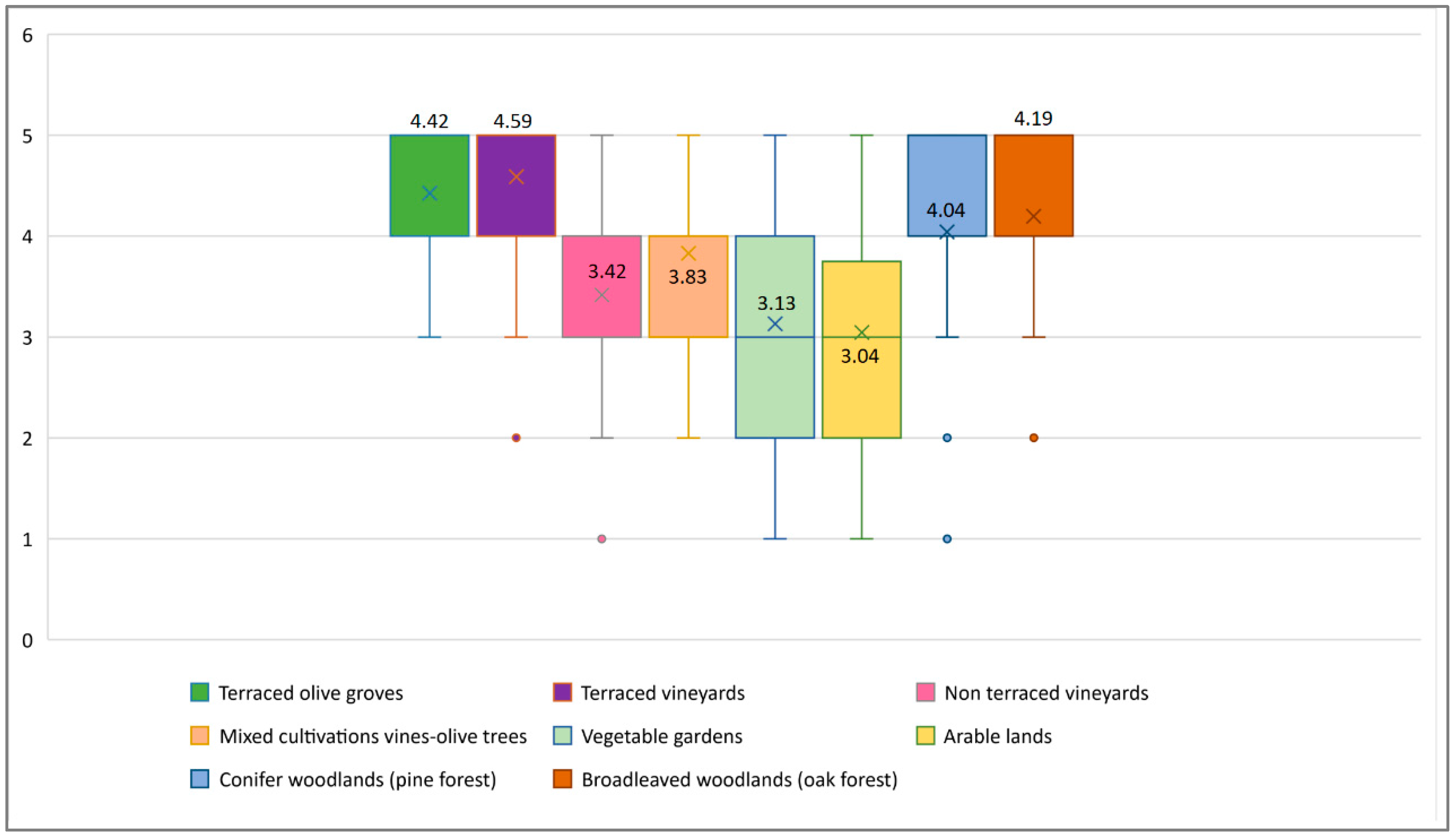
Results concerning the importance assigned to the different land uses are particularly interesting (
Figure 4). The highest values have been assigned to terraced vineyards (average assigned value equal to 4.6) and to terraced olive groves (4.4), while non-terraced vineyards (3.4), vegetable gardens (3.1), and arable land (3) have lower values. As well as the average values, the quartile disposition also shows that terraced cultivations are considered to be of higher importance. Mixed cultivations of vines and olive trees, once the typical cultivation of Chianti and nowadays almost disappeared, reach an average value equal to 3.8; some tourists had probably noticed these particular cultivations, but most of those interviewed did not perceive them as characteristic. The values assigned to woodlands are rather high, especially for oak forests (4.2), a sign that the typical landscape made of the alternation and integration between small woods and cultivations is particularly appreciated.
The choices concerning the proposed photographs confirms the previous results. Even though, for the first set of photographs, there was not a clear majority (in both cases, 55% of the interviewed preferred the terraced landscape of Lamole), for the second set of photographs, 77% chose the traditional composite landscape of Lamole and not the monocultural landscape.
Concerning the role of public institutions and the services for tourists that needed to be implemented, “paths and trails” was the answer chosen by 37% of the interviewed, followed by public transports (17%), touristic information (15%), and reception (14%).
4. Discussion
The results of the research are particularly interesting for different reasons. Lamole is actually a well-preserved historical landscape, mainly because of the main traditional features being maintained and restored by local farmers, such as terraced cultivations on small parcels, alternation between different types of cultivations (vineyards and olive groves), and forests. The landscape is today diversified as it was in the past. The number of land uses is almost the same; 19 different land uses in 1832 and 17 in 2016. On the other hand, important changes have occurred in the last two centuries due to the abandonment of some marginal areas once used mainly as pastures, the replacement of mixed cultivations with monocultures (even if it is important to highlight that small mixed cultivations of different types are still present), and the abandonment of integration between silvicultural and agricultural activities. Moreover, among the historical cultivations, it is necessary to mention the cultivation of iris (
Iris germanica L.), locally called
giaggiolo, once a traditional cultivation in the Province of Florence, used for producing essence for the cosmetic industry [
43]. Today, Lamole iris is no longer used for producing essence, but farmers still plant it at the end of the vine rows or along the terraces.
The landscape of Chianti is particularly appreciated by tourists, and the profile of the tourists visiting Chianti corresponds to couples who are more than 45 years old, with a high education level, who have visiting the area more than once. Tourists prefer the composite landscape made of small different cultivations and woodlands, compared to a vineyard monocultural landscape. Regarding the type of forests (broadleaved or conifer), there is not a clear preference, even if conifer woods are not characteristic of the area. The fact that conifer woods have never been managed has caused the evolution in recent years of these forests towards mixed forests, as natural broadleaved reforestation is ongoing.
Tourists also recognize the fact that some features, in particular dry-stone terraces, are very important for the place identity. Some other typical characteristics, historically important for the local landscape and now almost disappeared, such as mixed cultivations or pastures, are no longer perceived as something characteristic. The results seem to highlight the fact that tourists are aware of the characteristics of the landscape they are visiting, as they ask public institutions to implement the path and trails in order to deeply experience the local countryside. A correlation analysis has been carried out in order to investigate differences of landscape perception according to different age range, gender, country of origin, and education level. It seems that there is no significant correlation between the landscape perception results and the profile of the tourists, as has been confirmed by some similar studies [
44].
The main threat for agricultural heritage systems like the ones in Lamole is the abandonment of traditional agricultural practices. Recent studies at the European level found that the risk of abandonment at the farm level is strictly related to low income, low dynamism, an ageing population, and the small size of the farms [
45]. In this regard, Lamole agricultural systems seems to have a high risk of abandonment, as farm sizes are small, the average age of farmers is high, and the costs of producing on terraces are higher. The positive features that distinguish Lamole are instead related to the high quality of local products, the attractiveness of the place, and the sense of belonging to this place demonstrated by local farmers. These characteristics, which are common to other European traditional landscapes [
46], represent the driving forces that sector policies should invest in in order to promote their preservation and valorization.
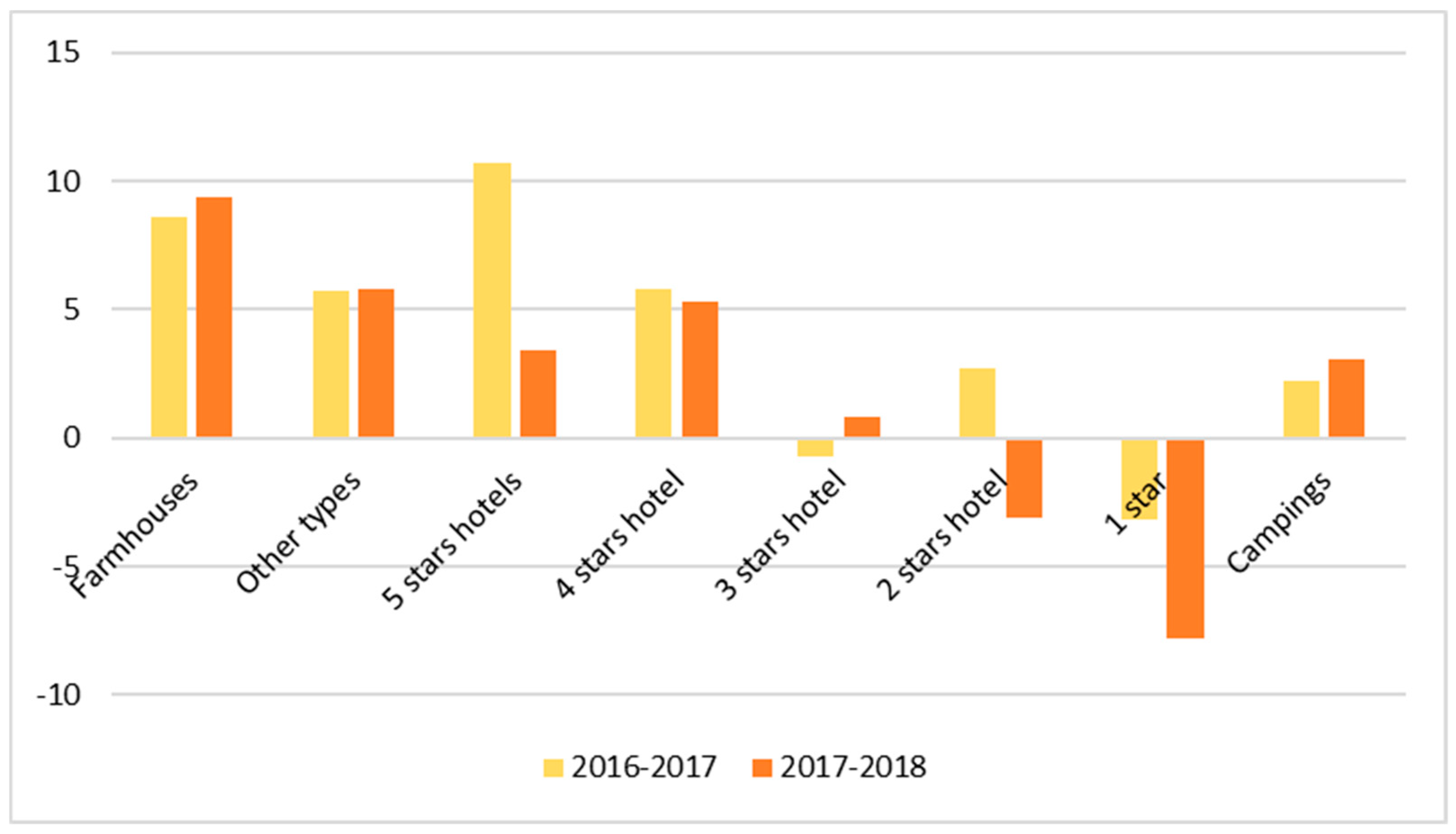
The economic importance of tourism in rural areas of Tuscany is the main reason that led public institution to preserve traditional landscapes. In Chianti, 2018 registered a 3.3% rise in the number of tourists (+5.5% for foreigners) compared to 2017, and in all of the Tuscany region farmhouses are the most common type of accommodation, followed by 5 stars hotels, with a most significant increase in terms of presences and in terms of number of available beds (
Figure 5) [
33].
In this sense, the fact that small farmers have decided to restore the ancient dry-stone terraces proves that they have recognized and felt what could be important for their own activities. Even before public institutions, farmers understood that the quality of the landscape is as important as the quality of products, in order to offer tourists a complete experience of their territories. The well-preserved historical landscape lends added value to the local products. According to different researches [
47,
48,
49,
50], external attributes are fundamental for the appreciation and purchase of wine by consumers. This is also confirmed for other typologies of local food products in other European countries [
51], as Cvijanović et al. [
52] recently demonstrated for Serbia. In fact, it is possible to find high quality wines in many places of the world, but associating the wine with a beautiful landscape or with personal experiences, such as being hosted in the farm where a wine is produced, automatically leads to an increase in the appreciation of that wine.
5. Conclusions
The majority of the landscape changes that have affected European agricultural heritage systems in the last 70 years are mainly due to two opposite dynamics; agricultural intensification in areas more easily cultivable, and the abandonment of cultivations in the marginal ones [
53,
54]. These processes occurred with greater intensity in the Mediterranean basin [
11], and the result is the simplification of traditional landscapes and the loss of traditional activities and agrobiodiversity.
The results of this research prove that the landscape of Lamole can still be considered an agricultural heritage system, even if the landscape is not totally the same as it was two hundred years ago. These kinds of transformations are inevitable, due to changes in productive systems and in the market, and are part of the concept of dynamic conservation, one of the main pillar of the GIAHS program, according to which it is necessary to emphasize the balance between conservation, adaptation, and socio-economic development [
55,
56].
The fact that small farmers started to restore the traditional terraces, improving both the quality of the products and of the landscape, often using their own funds, shows that they consider the traditional landscape as something important for their economic activities. The research has demonstrated that tourists recognize the traditional features of the Lamole landscape, as they have clearly expressed their preferences for the traditional mixed landscape. Considering the fact that tourism is a major resource for the Chianti area, public institutions should invest more in restoring traditional landscapes and supporting local farmers because tourism is a source of income and employment, acting as a lever for a whole series of activities [
57]. Moreover, it is also important to invest in communication, clarifying and explaining to visitors why the local landscape is so important, through leaflets, publications, information panels, and thematic trails, following requests from interviewed tourists who indicated that paths, trails, and touristic information were the main elements that could be improved.
The fact that forests are no longer regularly managed, and that the poles for the vineyards have to be bought elsewhere, is evidence that there is the necessity to reconnect forest and agricultural management as an integrated system. Another initiative that should be taken into consideration is the strengthening of the relationship between the quality of the local products and of the landscape. Regarding this last initiative, this is something already taken into consideration by the Italian Ministry for Agricultural Polices, which is thinking of creating a specific “landscape quality” label for the products coming from the areas inscribed in the National Register of Historical Rural Landscapes.
In recent years, it has become increasingly clear that, in order to improve the economy of rural areas, it is not possible to focus solely on the final agricultural product, but it is also necessary to focus on the unique character of traditional landscapes and on their multifunctional role. Tourists and consumers do not only look for a nice place to visit or a good wine, they are increasingly looking for something more, for complete experiences that bring them closer to the real core of a place and to the local people and traditions. For these reasons, agricultural heritage systems and traditional agricultural practices can represent a resource for the rural territories and for their economic development [
58,
59]. This is important not only for well-known places, such as Chianti, but also for rural areas with less developed economies but with strong traditional agricultural practices [
13,
60,
61], for which the inclusion in national or international programs can offer important opportunities.
At the national level, the inclusion of rural areas in the National Register of Historical Rural Landscapes has proven to be a good opportunity for increasing the quality of life of local farmers, mainly through tourism and the selling of local products. Moreover, the Ministry of Agricultural Policies is planning to allocate specific funds, including ones for Rural Development Plans, for areas included in the National Register, with the aim of supporting farmers who preserve the historical landscape though their activities. At the international level, the GIAHS program has demonstrated that applying a strategy of dynamic conservation to rural areas can lead to an effective improvement of socio-economic conditions. All these results, of course, can be reached only with the support of local authorities who can develop specific strategies and policies, especially concerning the creation of networks of farmers and other entities involved in rural tourism or in the promotion of high-quality local products. The inclusion in national or international programs is not enough to guarantee the achievement of the objectives of historical landscape preservation or the improvement of socio-economic conditions, but surely it is important to develop specific strategies.


