Suitability Analysis and Planning of Green Infrastructure in Montevideo, Uruguay
Abstract
1. Introduction
2. Materials and Methods
2.1. Study Area
2.1.1. Urban Expansion and Environmental Concerns
2.1.2. Climate Change in the Region
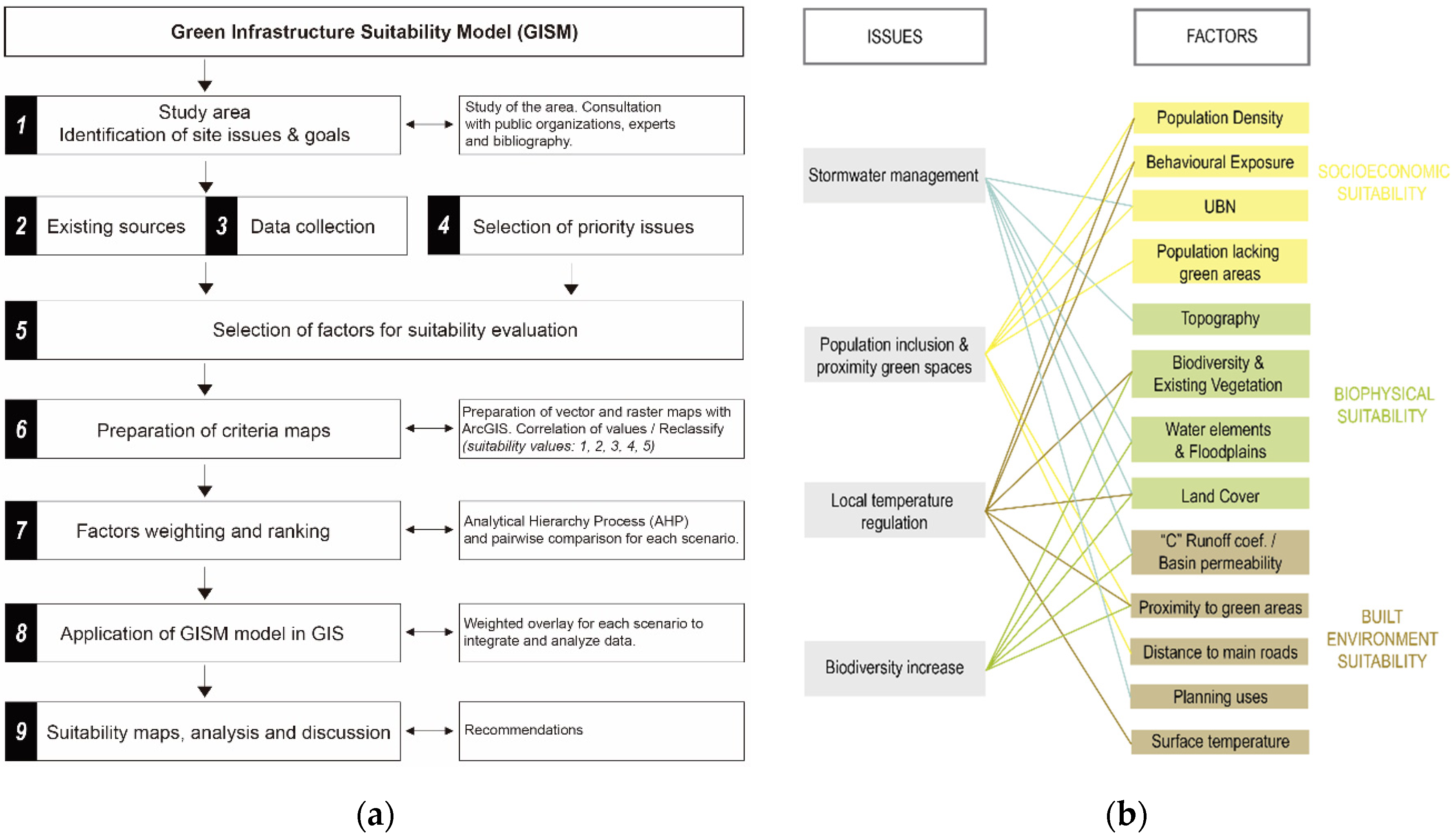
2.2. Methodology
2.2.1. Selection of Priority Issues
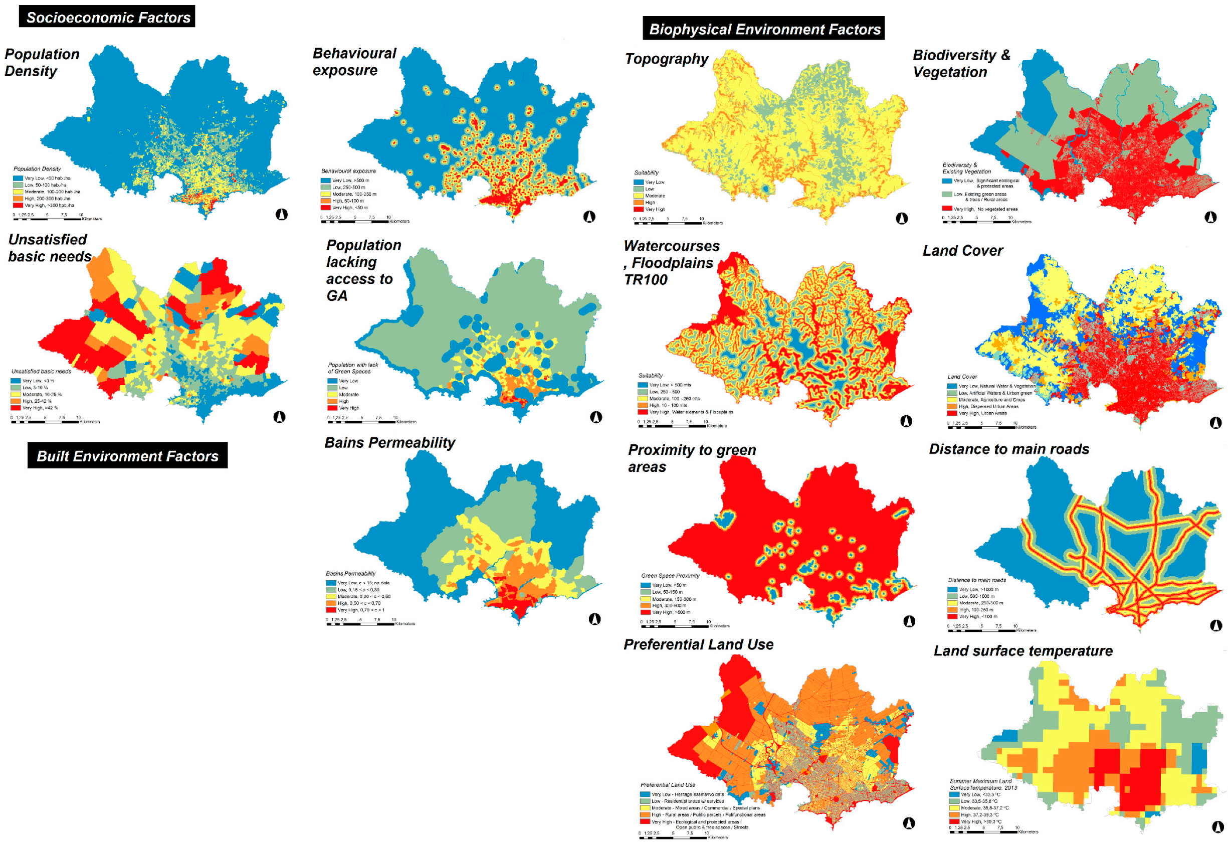
2.2.2. Selection of Factors for Suitability Evaluation
2.2.3. Preparation of Criteria Maps
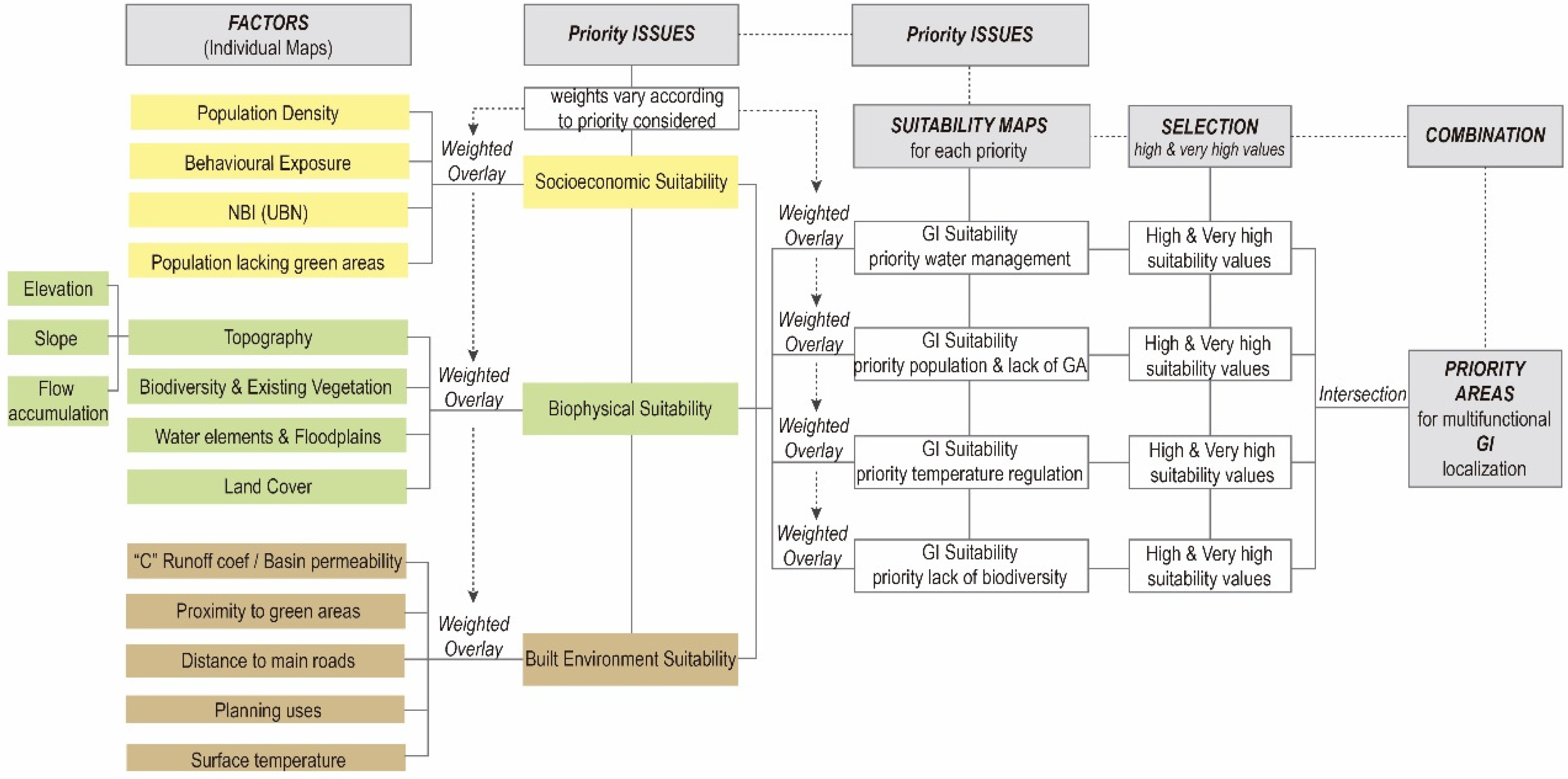
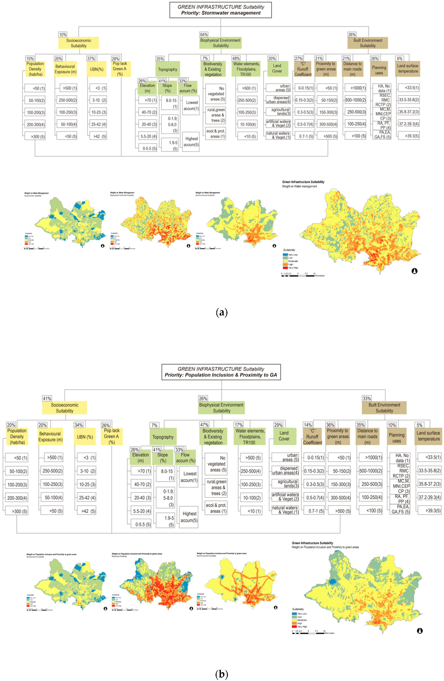
2.2.4. Factors Weighting and Ranking
2.2.5. Application of Green Infrastructure Suitability Model (GISM) in GIS
3. Results
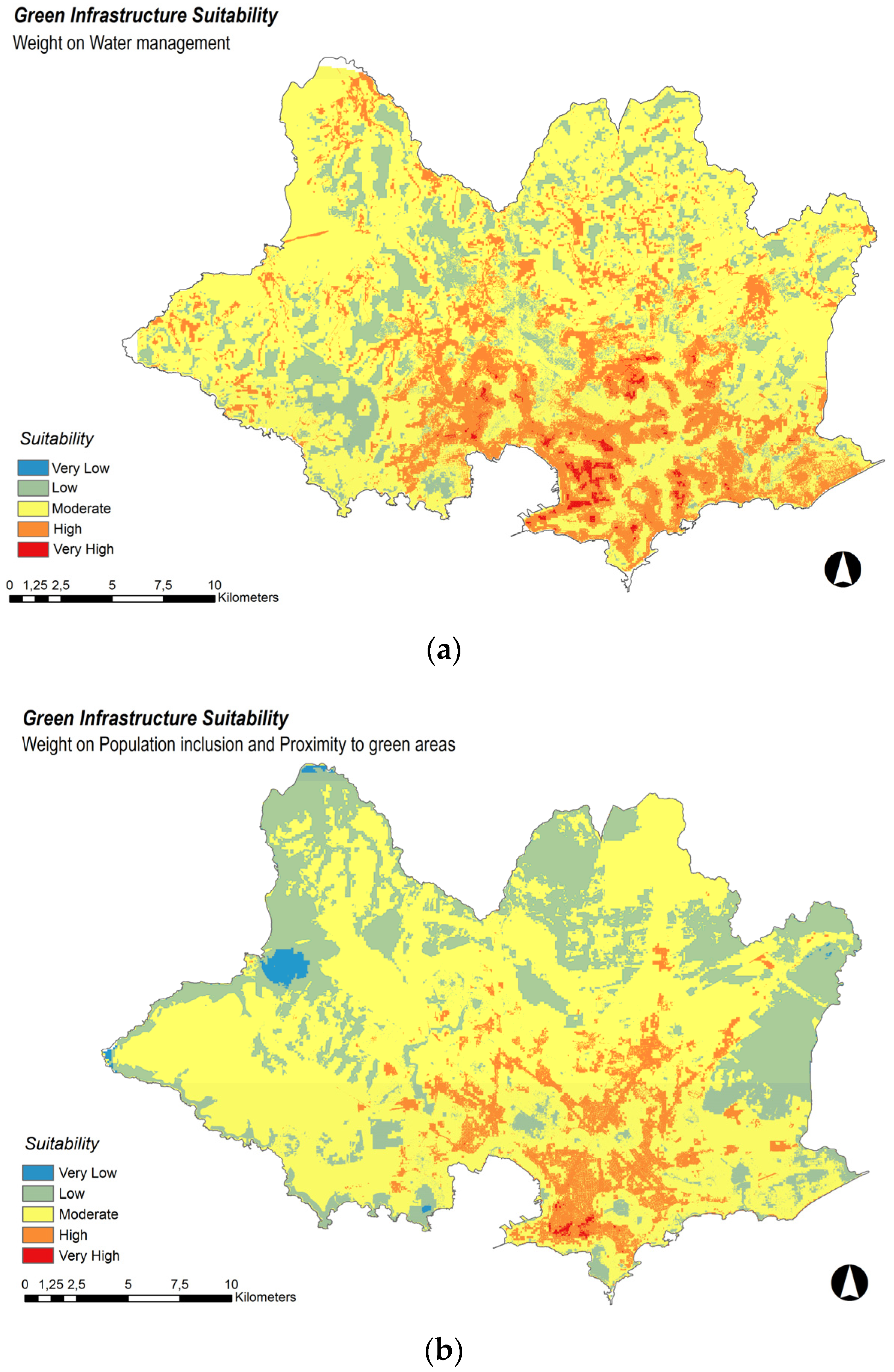
3.1. Priority: Stormwater Management
3.2. Priority: Population Inclusion and Proximity to Green Areas
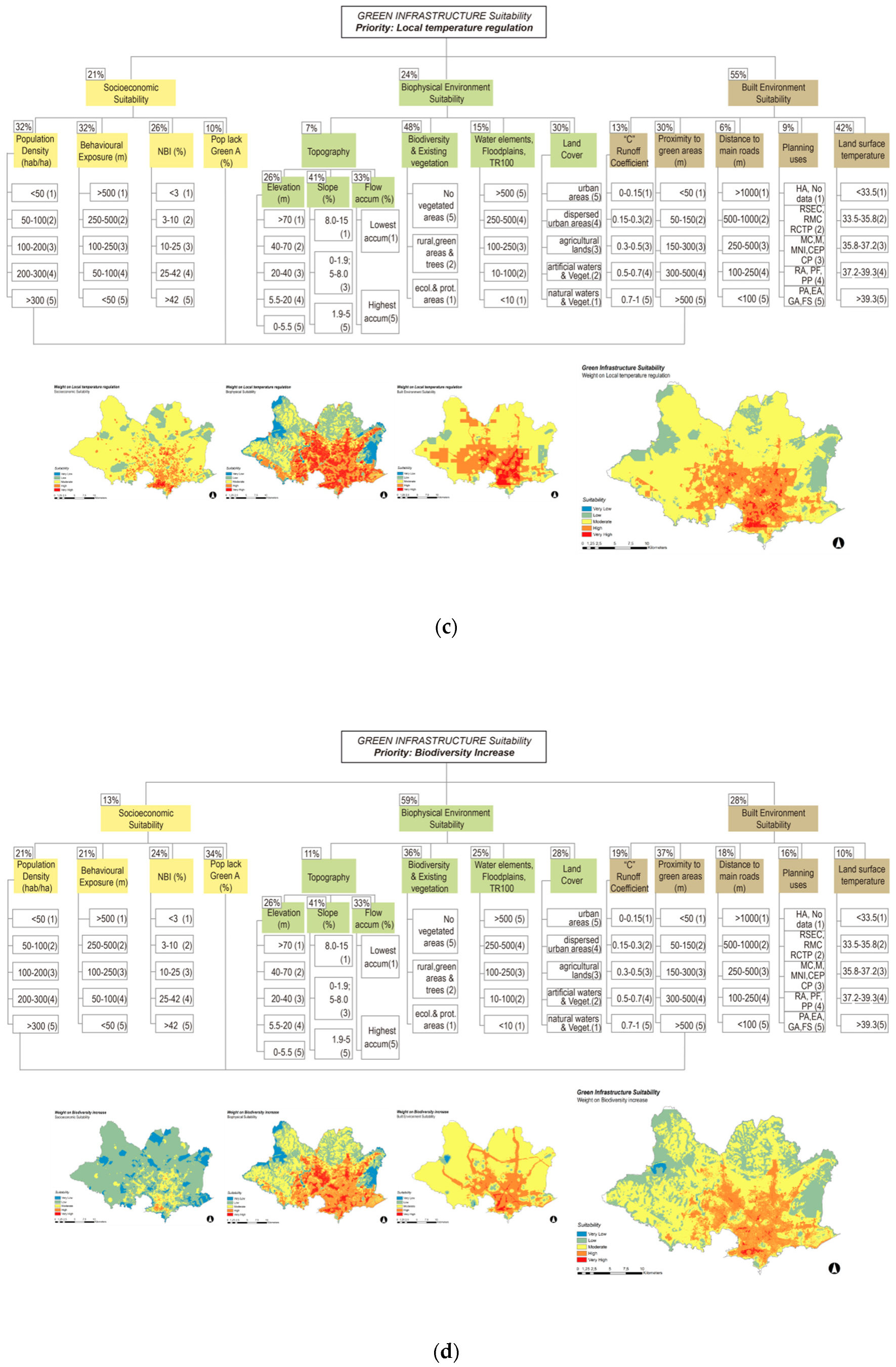
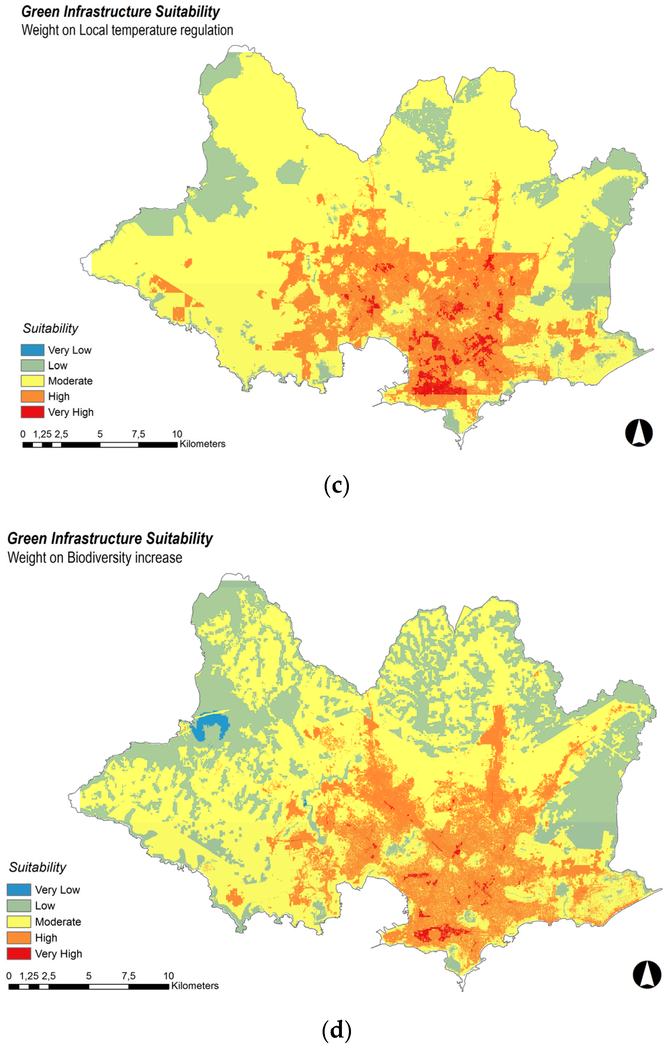
3.3. Priority: Local Temperature Regulation
3.4. Priority: Biodiversity Increase
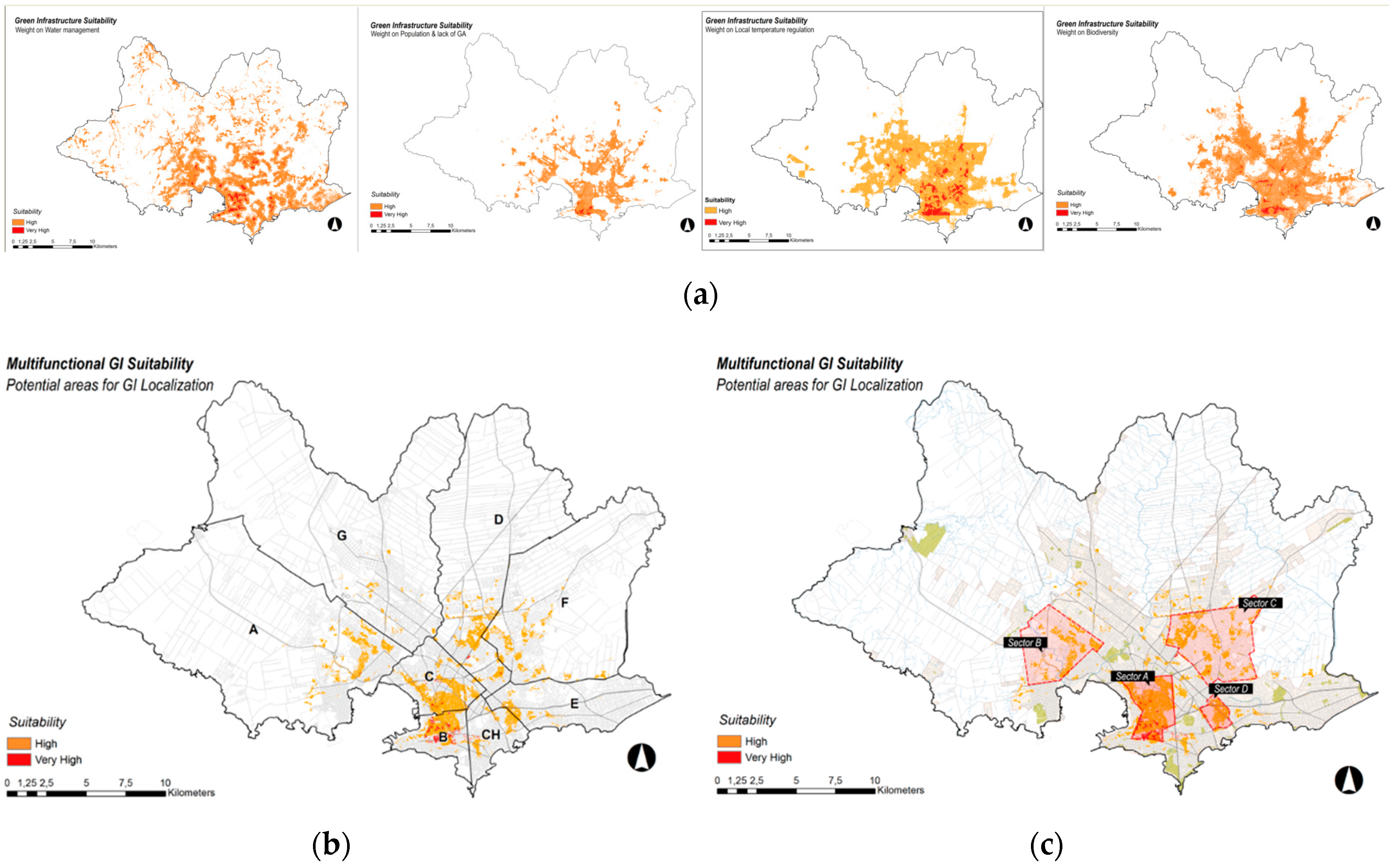
3.5. Selection of High and Very High Suitability Values
4. Discussion
5. Conclusions
Author Contributions
Funding
Acknowledgments
Conflicts of Interest
References
- United Nations Human Settlements Programme (UN-Habitat). World Cities Report 2016: Urbanization and Development-Emerging Futures; UN-Habitat: Nairobi, Kenya, 2016. [Google Scholar]
- Organisation for Economic Co-operation and Development (OECD); European Commission. Cities in the World: A New Perspective on Urbanisation; OECD: Paris, French, 2020. [Google Scholar]
- United Nations Environment Programme (UN Environment). Global Environment Outlook–GEO-6: Healthy Planet, Healthy People; UN Environment: Nairobi, Kenya, 2019. [Google Scholar]
- Mostafavi, M.; Doherty, G. Ecological Urbanism; Revised Edition (2016); Switzerland Lars Müller Publishers: Zürich, Switzerland, 2016. [Google Scholar]
- Liu, Z.; He, C.; Zhou, Y.; Wu, J. How much of the world’s land has been urbanized, really? A hierarchical framework for avoiding confusion. Landsc. Ecol. 2014, 29, 763–771. [Google Scholar] [CrossRef]
- Fragkias, M.; Lobo, J.; Strumsky, D.; Seto, K.C. Does size matter? Scaling of CO2 emissions and US urban areas. PLoS ONE 2013, 8, e64727. [Google Scholar] [CrossRef] [PubMed]
- The Nature Conservancy. Nature in the Urban Century: A Global Assessment of Where and How to Conserve Nature for Biodiversity and Human Wellbeing; The Nature Conservancy: Arlington, MA, USA, 2018. [Google Scholar]
- Smith, N.; Sinnett, D.; Burgess, S. Handbook on Green Infrastructure: Planning, Design and Implementation; Edward Elgar: Cheltenham, UK, 2015. [Google Scholar] [CrossRef]
- Mantyka-Pringle, C.S.; Visconti, P.; Di Marco, M.; Martin, T.G.; Rondinini, C.; Rhodes, J.R. Climate change modifies risk of global biodiversity loss due to land-cover change. Biol. Conserv. 2015, 187, 103–111. [Google Scholar] [CrossRef]
- Revi, A.; Satterthwaite, D.; Aragón-Durand, F.; Corfee-Morlot, J.; Kiunsi, R.; Pelling, M.; Roberts, D.; Solecki, W. Urban Areas in Climate Change 2014: Impacts, Adaptation, and Vulnerability. Part A: Global and Sectoral Aspects. Contribution of Working Group II to the Fifth Assessment Report of the Intergovernmental Panel on Climate Change; Cambridge University Press: Cambridge, UK; New York, NY, USA, 2014; pp. 535–612. [Google Scholar]
- Douglas, I.A.; James, P. Urban Ecology: An Introduction; Routledge: New York, NY, USA, 2015. [Google Scholar]
- Raymond, C.M.; Frantzeskaki, N.; Kabisch, N.; Berry, P.; Breil, M.; Nita, M.R.; Geneletti, D.; Calfapietra, C. A framework for assessing and implementing the co-benefits of nature-based solutions in urban areas. Environ. Sci. Policy 2017, 77, 15–24. [Google Scholar] [CrossRef]
- Frumkin, H.; Bratman, G.N.; Breslow, S.J.; Cochran, B.; Kahn, P.H., Jr.; Lawler, J.J.; Levin, P.S.; Tandon, P.S.; Varanasi, U.; Wolf, K.L.; et al. Nature Contact and Human Health: A Research Agenda. Environ. Health Perspect 2017, 125, 075001. [Google Scholar] [CrossRef]
- Bratman, G.N.; Anderson, C.B.; Berman, M.G.; Cochran, B.; de Vries, S.; Flanders, J.; Folke, C.; Frumkin, H.; Gross, J.J.; Hartig, T.; et al. Nature and mental health: An ecosystem service perspective. Sci. Adv. 2019, 5, eaax0903. [Google Scholar] [CrossRef]
- Andersson, E.; Haase, D.; Scheuer, S.; Wellmann, T. Neighbourhood character affects the spatial extent and magnitude of the functional footprint of urban green infrastructure. Landsc. Ecol. 2020, 35, 1605–1618. [Google Scholar] [CrossRef]
- Mell, I. Green Infrastructure: Concepts, Perceptions and Its Use in Spatial Planning. Thesis Submitted for the Degree of Doctor of Philosophy. Ph.D. Thesis, School of Architecture, Planning and Landscape, Newcastle University, England, UK, 2010. [Google Scholar]
- Ramyar, R.; Zarghami, E. Green infrastructure contribution for climate change adaptation in urban landscape context. Appl. Ecol. Environ. Res. 2017, 15, 1193–1209. [Google Scholar] [CrossRef]
- Mell, I. Green infrastructure: Reflections on past, present and future praxis. Landsc. Res. 2017, 42, 135–145. [Google Scholar] [CrossRef]
- Pauleit, S.; Liu, L.; Ahern, J.; Kazmierczak, A. Multifunctional Green Infrastructure Planning to Promote Ecological Services in the City. In Handbook of Urban Ecology; Oxford University Press: Oxford, UK, 2011; pp. 272–285. [Google Scholar] [CrossRef]
- Vásquez, A.; Galdámez, E.; Jara, R.; Navarro, V. Infraestructura Verde en Uruguay: Desafíos y Oportunidades; BID: Santiago, Chile, 2017. [Google Scholar]
- Intendencia de Montevideo (IM); 100 Resilient Cities. Montevideo Resiliente, Evaluación Preliminar de Resiliencia; IM: Montevideo, Uruguay, 2018. [Google Scholar]
- Ministerio de Vivienda Ordenamiento Territorial y Medio Ambiente (MVOTMA). Plan Nacional de Adaptación de Ciudades e Infraestructuras, Síntesis de Nap Ciudades, Complete Document; MVOTMA: Montevideo, Uruguay, 2018. [Google Scholar]
- Benedict, M.; McMahon, E. Green Infrastructure: Linking Landscapes and Communities; Island Press: Washington, WA, USA, 2006. [Google Scholar]
- Hansen, R.; Rall, E.; Chapman, E.; Rolf, W.; Pauleit, S. Urban Green Infrastructure Planning: A Guide for Practitioners. 2017. Available online: https://www.researchgate.net/publication/319967102_Urban_Green_Infrastructure_Planning_A_Guide_for_Practitioners (accessed on 30 July 2019).
- Hansen, R.; Pauleit, S. From Multifunctionality to Multiple Ecosystem Services? A Conceptual Framework for Multifunctionality in Green Infrastructure Planning for Urban Areas. AMBIO 2014, 43, 516–529. [Google Scholar] [CrossRef]
- Pickett, S.T.A.; Cadenasso, M.L.; Grove, J.M.; Boone, C.G.; Groffman, P.M.; Irwin, E.; Kaushal, S.S.; Marshall, V.; McGrath, B.P.; Nilon, C.H.; et al. Urban ecological systems: Scientific foundations and a decade of progress. J. Environ. Manag. 2011, 92, 331–362. [Google Scholar] [CrossRef] [PubMed]
- Biggs, R.; Rhode, C.; Archibald, S.; Kunene, L.M.; Mutanga, S.S.; Nkuna, N.; Ocholla, P.O.; Phadima, L.J. Strategies for managing complex social-ecological systems in the face of uncertainty: Examples from South Africa and beyond. Ecol. Soc. 2015, 20, 52. [Google Scholar] [CrossRef]
- Jones, S.; Somper, C. The role of green infrastructure in climate change adaptation in London. Geogr. J. 2014, 180, 191–196. [Google Scholar] [CrossRef]
- Staddon, C.; Ward, S.; De Vito, L.; Zuniga-Teran, A.; Gerlak, A.K.; Schoeman, Y.; Hart, A.; Booth, G. Contributions of green infrastructure to enhancing urban resilience. Environ. Syst. Decis. 2018, 38, 330–338. [Google Scholar] [CrossRef]
- European Commission. Towards an EU Research and Innovation policy agenda for Nature-Based Solutions & Re-Naturing Cities. Final Report of the Horizon 2020 Expert Group on ‘Nature-Based Solutions and Re-Naturing Cities’; European Commission: Brussels, Belgium, 2015. [Google Scholar] [CrossRef]
- Madureira, H.; Andresen, T. Planning for multifunctional urban green infrastructures: Promises and challenges. Urban Des. Int. 2014, 19, 38–49. [Google Scholar] [CrossRef]
- Meerow, S.; Newell, J. Spatial planning for multifunctional green infrastructure: Growing resilience in Detroit. Landsc. Urban Plan. 2017, 159, 62–75. [Google Scholar] [CrossRef]
- Instituto Nacional de Estadística (INE). Instituto Nacional de Estadística Uruguay. Available online: http://www.ine.gub.uy/ (accessed on 30 July 2019).
- Intendencia de Montevideo (IM). Estrategia de Resiliencia, Montevideo Resiliente; Unidad Ejecutiva de Resiliencia, IM: Montevideo, Uruguay, 2018. [Google Scholar]
- Intendencia de Montevideo (IM). Directrices Departamentales de Ordenamiento Territorial y Desarrollo Sostenible; IM: Montevideo, Uruguay, 2012. [Google Scholar]
- Ministerio de Vivienda Ordenamiento Territorial y Medio Ambiente (MVOTMA); Plan Nacional de Adaptación al Cambio Climático en Ciudades e Infraestructuras (NAP Ciudades). Cambia el Clima, Cambiemos Nosotros/as. Breve Guía Para Entender el Cambio Climático; MVOTMA: Montevideo, Uruguay, 2019. [Google Scholar]
- Intendencia de Montevideo (IM). Medidas de Resiliencia para Montevideo, Inundaciones y Saneamiento, División Saneamiento; Servicios de Estudio y Proyectos de Saneamiento (SEPS-IM): Montevideo, Uruguay, 2017. [Google Scholar]
- Piperno, A.; Sierra, P. Inundaciones en el Uruguay: Aportes desde el Ordenamiento Territorial; Instituto de Teoría de la Arquitectura y Urbanismo (ITU), Facultad de Arquitectura (FARQ), Universidad de la República (Udelar): Montevideo, Uruguay, 2010. [Google Scholar]
- Collins, M.G.; Steiner, F.R.; Rushman, M.J. Land-Use Suitability Analysis in the United States: Historical Development and Promising Technological Achievements. Environ. Manag. 2001, 28, 611–621. [Google Scholar] [CrossRef]
- Voogd, H. Multicriteria Evaluation for Urban and Regional Planning; Pion: London, UK, 1983. [Google Scholar]
- Keeney, R.L.; Raiffa, H. Decisions with Multiple Objectives: Preferences and Value Trade-Offs; Cambridge University Press: Cambridge, UK, 1976. [Google Scholar] [CrossRef]
- Carver, S.J. Integrating multi-criteria evaluation with geographical information systems. Int. J. Geogr. Inf. Syst. 1991, 5, 321–339. [Google Scholar] [CrossRef]
- Jankowski, P.; Richard, L. Integration of GIS-based suitability analysis and multicriteria evaluation in a spatial decision support system for route selection. Environ. Plan. B Plan. Des. 1994, 21, 323–340. [Google Scholar] [CrossRef]
- Thapa, R.B.; Murayama, Y. Land evaluation for peri-urban agriculture using analytical hierarchical process and geographic information system techniques: A case study of Hanoi. Land Use Policy 2008, 25, 225–239. [Google Scholar] [CrossRef]
- Cengiz, T.; Akbulak, C. Application of analytical hierarchy process and geographic information systems in land-use suitability evaluation: A case study of Dümrek village (Çanakkale, Turkey). Int. J. Sustain. Dev. World Ecol. 2009, 16, 286–294. [Google Scholar] [CrossRef]
- McHarg, I.L. Design with Nature; Published for the American Museum of Natural History [by] the Natural History Press: Garden City, NY, USA, 1969. [Google Scholar]
- Spósito, V. Strategic Thinking, Strategic Planning and Decision Making; Centre for Regional and Rural Futures, Faculty of Science, Engineering and Built Environment, Deakin University: Victoria, Australia, 2018. [Google Scholar]
- Norton, B.A.; Coutts, A.M.; Livesley, S.J.; Harris, R.J.; Hunter, A.M.; Williams, N.S.G. Planning for cooler cities: A framework to prioritise green infrastructure to mitigate high temperatures in urban landscapes. Landsc. Urban Plan. 2015, 134, 127–138. [Google Scholar] [CrossRef]
- Saaty, T.L.; De Paola, P. Rethinking Design and Urban Planning for the Cities of the Future. Buildings 2017, 7, 76. [Google Scholar] [CrossRef]
- Saaty, T.L. Decision Making for Leaders: The Analytic Hierarchy Process for Decisions in a Complex World; RWS Publications: Pittsburgh, PA, USA, 1995. [Google Scholar]
- Bantayan, N.C.; Bishop, I.D. Linking objective and subjective modelling for landuse decision-making. Landsc. Urban Plan. 1998, 43, 35–48. [Google Scholar] [CrossRef]
- Goepel, K.D.; AHP Analytic Hierarchy Process (EVM multiple inputs). Version 04.05.2016. Free web based AHP software. Available online: https://bpmsg.com/ (accessed on 30 July 2019).
- ESRI ArcMap GIS 10.5.1. Computer Software; Environmental Systems Research Institute, Inc.: Redlands, CA, USA, 2017.
- Intendencia de Montevideo (IM); 100 Resilient Cities; ARUP. Reporte Final Taller de Lanzamiento Montevideo Resiliente; IM: Montevideo, Uruguay, 2019. [Google Scholar]
Publisher’s Note: MDPI stays neutral with regard to jurisdictional claims in published maps and institutional affiliations. |
© 2020 by the authors. Licensee MDPI, Basel, Switzerland. This article is an open access article distributed under the terms and conditions of the Creative Commons Attribution (CC BY) license (http://creativecommons.org/licenses/by/4.0/).
Share and Cite
Apud, A.; Faggian, R.; Sposito, V.; Martino, D. Suitability Analysis and Planning of Green Infrastructure in Montevideo, Uruguay. Sustainability 2020, 12, 9683. https://doi.org/10.3390/su12229683
Apud A, Faggian R, Sposito V, Martino D. Suitability Analysis and Planning of Green Infrastructure in Montevideo, Uruguay. Sustainability. 2020; 12(22):9683. https://doi.org/10.3390/su12229683
Chicago/Turabian StyleApud, Agustina, Robert Faggian, Victor Sposito, and Diego Martino. 2020. "Suitability Analysis and Planning of Green Infrastructure in Montevideo, Uruguay" Sustainability 12, no. 22: 9683. https://doi.org/10.3390/su12229683
APA StyleApud, A., Faggian, R., Sposito, V., & Martino, D. (2020). Suitability Analysis and Planning of Green Infrastructure in Montevideo, Uruguay. Sustainability, 12(22), 9683. https://doi.org/10.3390/su12229683


