Geomorphological and Geochronological Analysis Applied to the Quaternary Landscape Evolution of the Yeltes River (Salamanca, Spain)


Abstract
1. Introduction
2. Geology and Geography of the Study Area
3. Materials and Methods
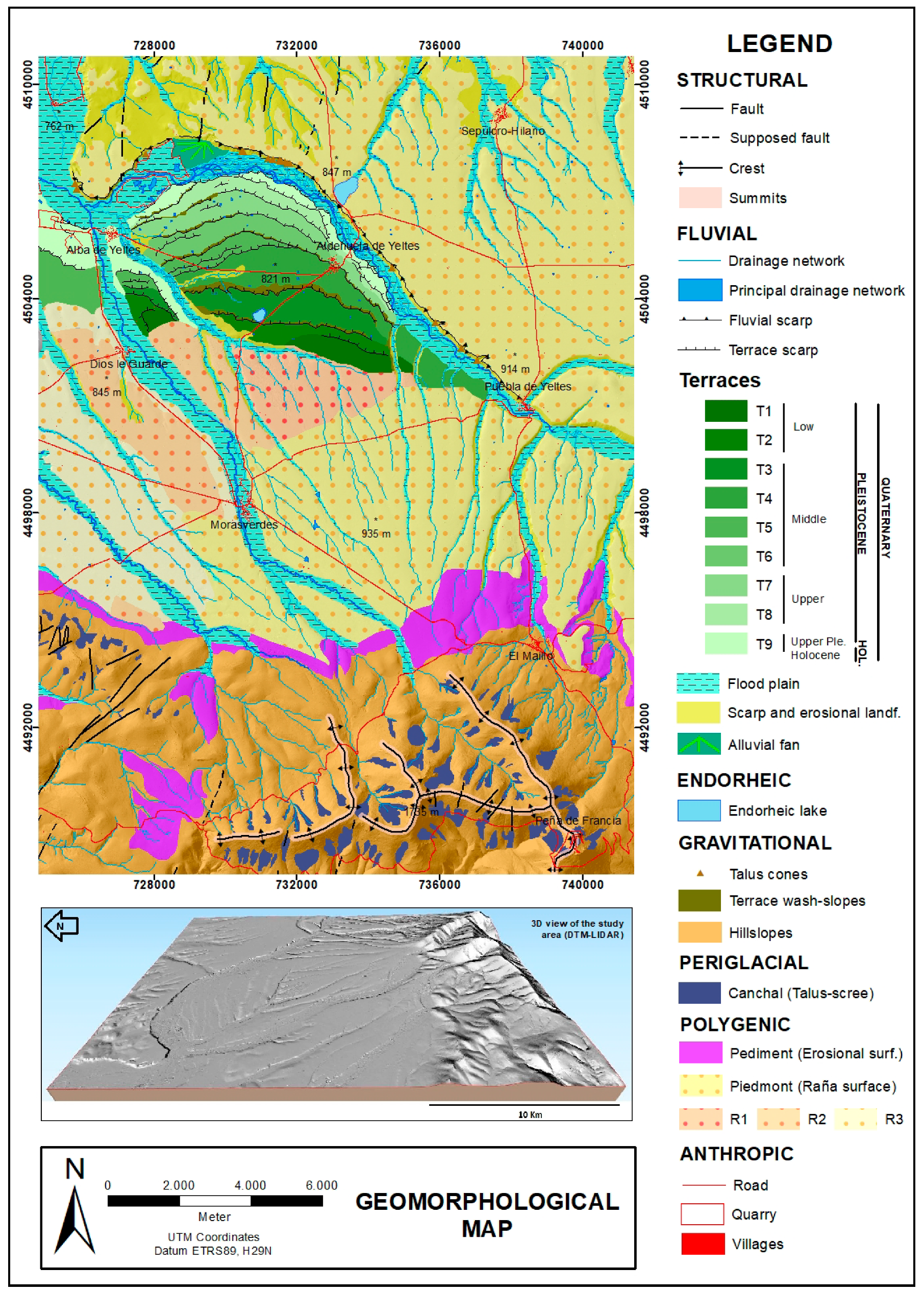
3.1. Geomorphological Mapping
3.2. Geochronological Analysis
4. Results and Discussion
4.1. Geomorphology
4.2. Fluvial Terrace Sequence of the Yeltes River
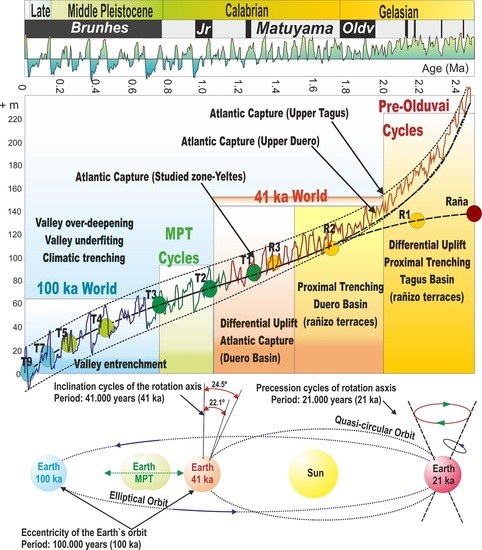
4.3. Geochonology
4.4. Discussion: Quaternary Landscape Evolution of Yeltes River
5. Conclusions
Author Contributions
Funding
Acknowledgments
Conflicts of Interest
References
- Cunha, P.P.; Martins, A.A.; Gomes, A.; Stokes, M.; Cabral, J.; Lopes, F.C.; Pereira, D.; De Vicente, G.; Buylaert, J.P.; Murray, A.S.; et al. Mechanisms and age estimates of continental-scale endorheic to exorheic drainage transition: Douro River, Western Iberia. Glob. Planet. Chang. 2019, 181, 102985. [Google Scholar] [CrossRef]
- Pérez-González, A.; Gallardo, J. La Raña al sur de la Somosierra y Sierra de Ayllón; un piedemonte escalonado del Villafranquiente medio. Geogaceta 1987, 2, 29–32. [Google Scholar]
- Martín Serrano, A. Sobre la positión de la raña en el contexto morfodinámico de la Meseta. Planteamientos Antiguos y Tendencias Actuales. Bol. Geol. Min. 1988, 99, 855–870. [Google Scholar]
- Martín Serrano, A. La definición y el encajamiento de la red fluvial actual sobre el Macizo Hespérico en el marco de su geodinámica alpina. Rev. Soc. Geol. Esp. 1991, 4, 337–351. [Google Scholar]
- Martín Serrano, A. El relieve del Macizo Hespérico; genesis y cronologia de los principales elementos morfologicos. Cuader. Lab. Xeol. Laxe 1994, 19, 37–55. [Google Scholar]
- Gutierrez Elorza, M.; Garcia Ruiz, J.M.; Goy, J.L.; Gracia Prieto, F.J.; Gutierrez Santolalla, F.; Marti, C.; Martin Serrano, A.; Pérez-González, A.; Zazo, C.; Aguirre, E. Quaternary. In The Geology of Spain; Gibbons, W., Moreno, T., Eds.; Geological Society: Bath, UK, 2002; pp. 335–366. [Google Scholar]
- Pereira, D.I.; Pereira, P.; Brilha, J.; Cunha, P.P. The Iberian Massif Landscape and Fluvial Network in Portugal: A geoheritage inventory based on the scientific value. Proc. Geol. Assoc. 2015, 126, 252–265. [Google Scholar] [CrossRef]
- Bridgland, D.; Westaway, R. Climatically controlled river terrace staircases: A worldwide Quaternary phenomenon. Geomorphology 2008, 98, 285–315. [Google Scholar] [CrossRef]
- Westaway, R.; Bridgland, D.R.; Sinha, R.; Demir, T. Fluvial sequences as evidence for landscape and climatic evolution in the Late Cenozoic: A synthesis of data from IGCP 518. Glob. Planet. Chang. 2009, 68, 237–253. [Google Scholar] [CrossRef]
- Macklin, M.G.; Lewin, J.; Woodward, J.C. The fluvial record of climate change. Philos. Trans. R. Soc. 2012, A370, 2143–2172. [Google Scholar] [CrossRef]
- Bridgland, D.R. River terrace systems in north-west Europe: An archive of environmental change, uplift and early human occupation. Quat. Sci. Rev. 2000, 19, 1293–1303. [Google Scholar] [CrossRef]
- Chorley, R.; Schumm, S.A.; Sudgen, D.E. Geomorphology. Earth Sciences and the Past; Methuen: London, UK, 1984; p. 605. [Google Scholar]
- Stokes, M.; Cunha, P.P.; Martins, A.A. Techniques for analysing Late Cenozoic river terrace sequences. Geomorphology 2012, 165–166, 1–6. [Google Scholar] [CrossRef]
- Julivert, M.; Fonboté, J.M.; Ribeiro, A.; Conde, L. Mapa Tectónico de la Península Ibérica y Baleares. Escala 1:1.000.000; Instituto Geológico y Minero de España (IGME): Madrid, Spain, 1974; p. 113. [Google Scholar]
- Ugidos, J.M.; Rodríguez Alonso, M.D.; Albert Colomert, V.; Martín Herrero, D. Cartografía y Memoria de la Hoja nº 552 (Miranda del Castañar). Escala 1:50.000; Plan MAGNA; ITGE: Madrid, Spain, 1990; p. 81. [Google Scholar]
- Ugidos, J.M.; Rodríguez Alonso, M.D.; Martín Herrero, D.; Bascones Alvira, L. Cartografía y Memoria de la Hoja nº 575 (Hervás). Escala 1:50.000; Plan MAGNA; ITGE: Madrid, Spain, 1988; p. 86. [Google Scholar]
- Bascones Alvira, L.; Rodriguez Alonso, M.D. Cartografía y memoria de la Hoja n° 526 (Serradilla del Arroyo), Escala 1:50.000; Plan MAGNA; ITGE: Madrid, Spain, 1990; p. 72. [Google Scholar]
- Cantano, M. Evolución Morfodinámica del Sector Suroccidental de la Cuenca de Ciudad Rodrigo, Salamanca. Ph.D. Thesis, Universidad de Huelva, Huelva, Spain, 1997; p. 277. [Google Scholar]
- Martín-Serrano García, A.; Monteserín López, V.; Mediavilla López, R.; Rubio Pascual, F.; Santiesteban Navarro, J.I. Cartografía y Memoria de la Hoja nº 501 (La Fuente de San Esteban). Escala 1:50.000; Plan MAGNA; ITGE: Madrid, Spain, 1991; p. 76. [Google Scholar]
- Martín Herrero, D.; Ugidos Meana, J.M.; Nozal Martín, F.; Pardo Alonso, M.V. Cartografía y Memoria de la Hoja nº 527 (Tamames). Escala 1:50.000; Plan MAGNA; ITGE: Madrid, Spain, 1990; p. 98. [Google Scholar]
- Martín-Serrano García, A.; Monteserín López, V.; Mediavilla López, R.; Nozal Martín, F.; Diez Balda, M.A.; Pardo Alonso, M.V.; Carral González, M.P.; Rubio Pascual, F. Cartografía y Memoria de la Hoja n° 502 (Matilla de los Caños del Río). Escala 1:50.000; Plan MAGNA; ITGE: Madrid, Spain, 1993; p. 76. [Google Scholar]
- Silva, P.G.; Roquero, E.; López-Recio, M.; Huerta, P.; Martínez-Graña, A.M. Chronology of fluvial terrace sequences for large Atlantic Rivers in the Iberian Peninsula (Upper Tagus and Duero drainage basins, Central Spain). Quat. Sci. Rev. 2017, 166, 188–203. [Google Scholar] [CrossRef]
- Martín-Martín, I. Evolución Geomorfológica del Río Yeltes (Salamanca) Durante el Cuaternario. Master’s Thesis, Universidad de Salamanca, Salamanca, Spain, 2019; p. 45. [Google Scholar]
- Goy, J.L.; Rodriguez-López, G.; Martínez-Graña, A.M.; Cruz, R.; Valdés, V. Geomorphological analysis applied to the evolution of the quaternary landscape of the Tormes River (Salamanca, Spain). Sustainability 2019, 11, 7255. [Google Scholar] [CrossRef]
- Rodríguez-Rodríguez, L.; Antón, L.; Rodés, A.; Pallàs, R.; García-Castellanos, D.; Jiménez-Munt, I.; Struth, L.; Leannig, L.; ASTER Team. Dates and rates of endo-exorheic drainage development: Insights from fluvial terraces (Duero River, Iberian Peninsula). Glob. Planet. Chang. 2020, 193, 103271. [Google Scholar] [CrossRef]
- Karampaglidis, T.; Benito-Calvo, A.; Rodés, A.; Braucher, R.; Pérez-González, A.; Pares, J.; Stuart, F.; Di Nicola, L.; Bourles, D. Pliocene endoreheic-exhoreic drainage transition of the Cenozoic Madrid Basin (Central Spain). Glob. Planet. Chang. 2020, 194, 103295. [Google Scholar] [CrossRef]
- Martínez Graña, A.M. Estudio Geológico Ambiental Para la Ordenación de los Espacios Naturales de “Las Batuecas-Sierra de Francia” y “Quilamas”. Aplicaciones Geomorfológicas al Paisaje, Riesgos e Impactos, Análisis Cartográfico Mediante SIG. Ph.D. Thesis, Universidad de Salamanca, Salamanca, Spain, 2010; p. 806. [Google Scholar]
- Bishop, M.P.; James, L.A.; Shroder, J.F.; Walsh, S.J. Geospatial technologies and digital geomorphological mapping: Concepts, issues and research. Geomorphology 2012, 137, 5–26. [Google Scholar] [CrossRef]
- Gustavsson, M.; Kolstrup, E.; Seijmonsbergen, A.C. A new symbol-and-GIS based detailed geomorphological mapping system: Renewal of a scientific discipline for understanding landscape development. Geomorphology 2006, 77, 90–111. [Google Scholar] [CrossRef]
- Martínez-Graña, A.M.; Goy, J.L.; Zazo, C.; Silva, P.G.; Santos-Francés, F. Configuration and evolution of the landscape from the geomorphological map in the Natural Parks Batuecas-Quilamas (Central System, SW Salamanca, Spain). Sustainability 2017, 9, 1458. [Google Scholar]
- Quesada-Román, A.; Zamorano-Orozco, J.J. Geomorphology of the Upper General River Basin, Costa Rica. J. Maps 2019, 15, 95–101. [Google Scholar] [CrossRef]
- Veleda, S.; Martínez-Graña, A.; Santos-Francés, F.; Sánchez-San Roman, J.; Criado, M. Analysis of the Hazard, Vulnerability and Exposure to the Risk of Flooding (Alba de Yeltes, Salamanca, Spain). Appl. Sci. 2017, 7, 157. [Google Scholar] [CrossRef]
- Jambrina, M.; Corrochano, A.; Armenteros, I. Sedimentología e hidrogeoquímica de las lagunas de “El Cristo” y de “La Cervera” (Salamanca, España). Stud. Geol. Salmanticiensia 2010, 46, 25–45. [Google Scholar]
- Bernat Rebollal, M.; Pérez-González, A. Campos de dunas y mantos eólicos de Tierra de Pinares (sureste de la cuenca del Duero, España). Bol. Geol. Min. 2005, 116, 23–38. [Google Scholar]
- Leopold, L.B.; Wolman, M.G.; Miller, J.P. Fluvial Processes in Geomorphology; Freeman: San Francisco, CA, USA, 1964; p. 522. [Google Scholar]
- Harden, C. Terrace, River. In Encyclopedia of Geomorphology; Goudie, A.S., Ed.; Routledge: London, UK, 2004; pp. 1039–1043. [Google Scholar]
- Roquero, E.; Silva, P.G.; Goy, J.L.; Zazo, C.; Massana, J. Soil evolution indices in fluvial terrace chronosequences from central Spain (Tagus and Duero fluvial basins). Quat. Int. 2015, 376, 101–113. [Google Scholar] [CrossRef]
- Gutiérrez-Elorza, M. Geomorfología, 1st ed.; Pearson-Prentice Hall: Madrid, Spain, 2008; p. 920. [Google Scholar]
- Martín-Serrano, A.; Cantano, M.; Carral, P.; Rubio, F.; Mediavilla, R. La degradación cuaternaria del piedemonte del río Yeltes (Salamanca). Cuat. Geomorfol. 1998, 12, 5–17. [Google Scholar]
- Silva, P.G.; Bardají, T.; Roquero, E.; Baena-Presley, J.; Cearreta, A.; Rodríguez-Pascua, M.A.; Rosas, A.; Zazo, C.; Goy, J.L. El Periodo Cuaternario: La Historia Geológica de la Prehistoria. Cuater. Geomorfol. 2017, 31, 7–24. [Google Scholar] [CrossRef]
- Antón, L.; De Vicente, G.; Muñoz-Martín, A.; Stokes, M. Using river long profiles and geomorphic indices to evaluate the geomorphological signature of continental scale drainage capture, Duero basin (NW Iberia). Geomorphology 2014, 206, 250–261. [Google Scholar] [CrossRef]
- Clark, P.U.; Archen, D.; Pollard, D.; Blum, J.D.; Rial, J.A.; Brovkin, V.; Mix, A.C.; Pisisas, N.G.; Roy, M. The mid-Pleistocene transition: Characteristic mechanisms and implications for long-term changes in atmospheric pCO2. Quat. Sci. Rev. 2006, 25, 3150–3184. [Google Scholar] [CrossRef]


| M. S. | Domain | Landforms | Description | Age |
|---|---|---|---|---|
| M. S. Structural | Structural Landforms | Fault | Fractures on materials that condition the structural reliefs and drainage orientations | Carboniferous (Variscan orogeny) |
| Suspect fault | Probable fractures from photointerpretation not verified in the field | Carboniferous (Variscan orogeny) | ||
| Crest | Narrow ridges (hogback-type) mainly developed on resistant quartzites | Paleogene-Neogene (Alpine orogeny) | ||
| Summits | Water-divides within the mountain area, usually coincides with quartzite crests | Paleogene-Neogene (Alpine orogeny) | ||
| M. S. Fluvial | Fluvial-Alluvial Landforms | Drainage network | Present set of river and stream channels allowing water erosion and sediment transport | Holocene |
| Flood plain | Alluvial surface adjacent to a river subject to periodic/episodic flooding | Holocene | ||
| Terrace scarp | Topographic steps (slope-ruptures) between the different terrace levels | Holocene-Pleistocene | ||
| Fluvial Terrace | Ancient floodplains hang up several meters above the present river thalweg, resulting from consecutive cycles of river downcutting and sedimentation | Holocene-Pleistocene | ||
| Fluvial escarpments | Slope ruptures generated by the erosive action of the rivers | Holocene-Pleistocene | ||
| Alluvial fan | Fan-shaped alluvial sedimentary bodies generated at the toe of large escarpments which extends radially downslope | Holocene-Pleistocene | ||
| Erosional landforms | Areas excavated and shaped by river action in Neogene sediments | Holocene-Pleistocene | ||
| M. S. Lacustrine | Endorheic Landforms | Small lakes, ponds | Endorheic lakes of hydro-eolian origin favored by differential erosion along structural elements | Pleistocene |
| M.S. Gravitational | Slope Landforms | Talus cones | Debris accumulations related to gully erosion and escarpments retreat | Holocene |
| Hillslopes | Steep slopes in a mountainous area, where various gravitational processes occur | Holocene-Upper Pleistocene | ||
| Terrace wash-slopes | Accumulations developed with the erosion of the terrace escarpments | Holocene-Pleistocene | ||
| M. S. Periglacial | Periglacial Landforms | Talus-scree (Canchales) | Talus-slope accumulations of angular clasts in elevated zones at the foot of large quartzite crests and rock walls | Holocene-Upper Pleistocene |
| M.S. Polygenic | Polygenic surfaces and Landforms | Glacis | Glacis-type deposits coming from the reworking of raña deposits composed of relatively angular clasts. It could be considered as the first terrace | Lower Pleistocene |
| Raña surface (Piedmont) | Extensive alluvial sedimentary platforms and deposits unconformably placed on top of the Neogene sedimentary filling of the basin | Pliocene-Pleistocene | ||
| Pediment | Exhumed relic rocky surface free of the older overlaying weathering profile (removed by erosion) | Pliocene | ||
| M. S. Anthropogenic | Anthropogenic Elements | Roads | Main road network | Modern |
| Quarry | Aggregate extraction quarries (Gravelly) | Modern | ||
| Villages | Localities (sites) | Historic |
| Chronofunction name | Equation (R2) |
|---|---|
| 2nd Order polynomial function (Duero Basin) [a] | y = 0.098x2 + 8.057x − 16.38 (R2 0.96) |
| Power Function for Arlanzón valley (Duero Basin) [b] | y = 2.942x1.37 (R2 0.92) |
| 3rd Order polynomial function (Duero + Tagus Basin) [c] | y = −0.001x3 + 0.199x2 + 4.38x − 21.16 (R2 0.98) |
| 2nd Order polynomial function (Duero + Tagus Basin) [d] | y = 0.085x2 + 8.05x − 38.59 (R2 0.96) |
| Terraces | Relative Height (m) | [a] 2nd Order Polynomial Duero (ky) | [b] Power Function Arlanzón Valley (ky) | [c] 3rd Order Polynomial Duero + Tagus (ky) | [d] 2nd Order Polynomial Duero + Tagus (ky) |
|---|---|---|---|---|---|
| T9 | +3–4 | 13.04 | 16.45 | −3.39 | −9.35 |
| T8 | +6–8 | 44.92 | 42.53 | 19.09 | 22.01 |
| T7 | +12–14 | 105.02 | 98.95 | 67.37 | 80.51 |
| T6 | +18–20 | 172.18 | 166.28 | 127.18 | 145.13 |
| T5 | +28–30 | 299.79 | 296.66 | 248.94 | 266.43 |
| T4 | +31–35 | 424.18 | 422.24 | 370.74 | 383.35 |
| T3 | +51–55 | 686.32 | 677.73 | 627.17 | 627.17 |
| T2 | +67–70 | 995.59 | 962.92 | 891.19 | 911.87 |
| T1 | +82–86 | 1352.29 | 1273.41 | 1157.99 | 1237.71 |
| R3 | +89–92 | 1515.64 | 1410.20 | 1263.71 | 1386.30 |
| R2 | +100–105 | 1839.69 | 1672.63 | 1440.97 | 1680.10 |
| R1 | +118–122 | 2362.05 | 2075.64 | 1641.40 | 2151.75 |
| Raña | +134–138 | 2822.95 | 2414.22 | 2822.95 | 2822.95 |
| Terraces | Relative Height (m) | Numerical Age (ky) | Error (± ky) | Epoch/Subepoch | MIS |
|---|---|---|---|---|---|
| T9 | +3–4 | 14.75 | 3.8 | Holocene-Upper Pleist. | 2–1 |
| T8 | +6–8 | 43.72 | 8.8 | Upper Pleistocene | 3 |
| T7 | +12–14 | 101.98 | 10.5 | Upper Pleistocene | 5 |
| T6 | +18–20 | 169.23 | 11.9 | Chibanian (Mid. Pleist) | 7–6 |
| T5 | +28–30 | 298.22 | 13.9 | Chibanian (Mid. Pleist) | 9–8 |
| T4 | +31–35 | 423.21 | 38.5 | Chibanian (Mid. Pleist) | 11 |
| T3 | +51–55 | 682.02 | 36.0 | Chibanian (Mid. Pleist) | 17 |
| T2 | +67–70 | 979.25 | 30.6 | Calabrian (Low. Pleist) | 25 |
| T1 | +82–86 | 1312.85 | 45.3 | Calabrian (Low. Pleist) | 43 |
| R3 | +89–92 | 1462.92 | 35.4 | Calabrian (Low. Pleist) | 51 |
| R2 | +100–105 | 1756.16 | 63.1 | Gelasian (Low. Pleist) | 65 |
| R1 | +118–122 | 2218.84 | 55.3 | Gelasian (Low. Pleist) | 89 |
| Raña | +134–138 | 2618.58 | 84.3 | Late Pliocene | > 103 |
© 2020 by the authors. Licensee MDPI, Basel, Switzerland. This article is an open access article distributed under the terms and conditions of the Creative Commons Attribution (CC BY) license (http://creativecommons.org/licenses/by/4.0/).
Share and Cite
Martín-Martín, I.; Silva, P.-G.; Martínez-Graña, A.; Elez, J. Geomorphological and Geochronological Analysis Applied to the Quaternary Landscape Evolution of the Yeltes River (Salamanca, Spain). Sustainability 2020, 12, 7869. https://doi.org/10.3390/su12197869
Martín-Martín I, Silva P-G, Martínez-Graña A, Elez J. Geomorphological and Geochronological Analysis Applied to the Quaternary Landscape Evolution of the Yeltes River (Salamanca, Spain). Sustainability. 2020; 12(19):7869. https://doi.org/10.3390/su12197869
Chicago/Turabian StyleMartín-Martín, Iván, Pablo-Gabriel Silva, Antonio Martínez-Graña, and Javier Elez. 2020. "Geomorphological and Geochronological Analysis Applied to the Quaternary Landscape Evolution of the Yeltes River (Salamanca, Spain)" Sustainability 12, no. 19: 7869. https://doi.org/10.3390/su12197869
APA StyleMartín-Martín, I., Silva, P.-G., Martínez-Graña, A., & Elez, J. (2020). Geomorphological and Geochronological Analysis Applied to the Quaternary Landscape Evolution of the Yeltes River (Salamanca, Spain). Sustainability, 12(19), 7869. https://doi.org/10.3390/su12197869