Photogrammetric Measurement of Erosion at the Sabbath Point Beothuk Site in Central Newfoundland, Canada


Abstract
1. Introduction
Regional Settings and Archaeological Background
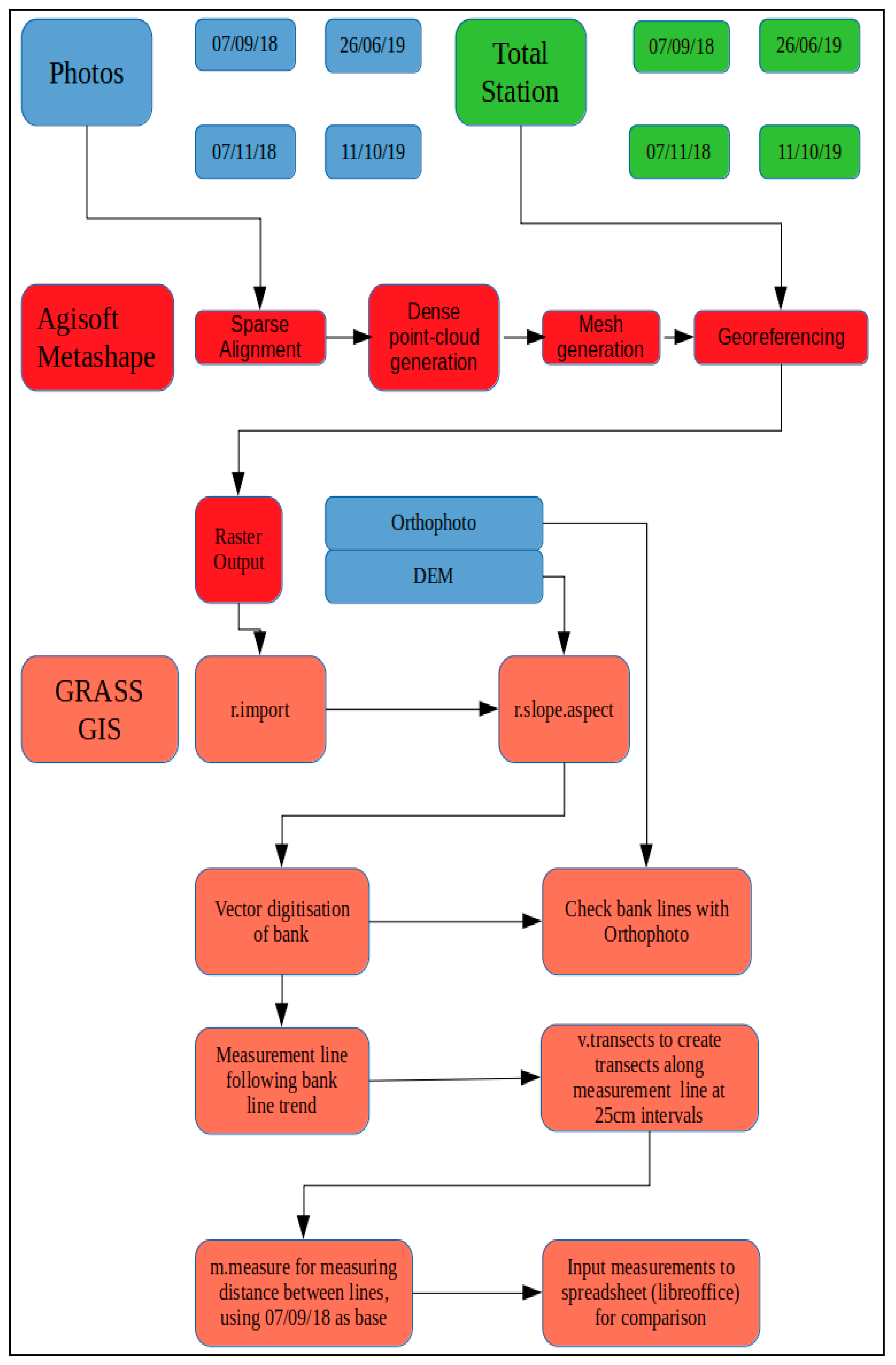
2. Materials and Methods
2.1. Photograph Acquisition
2.2. Image-Based Modelling Method
2.3. Geographic Information System (GIS) Processing
3. Results
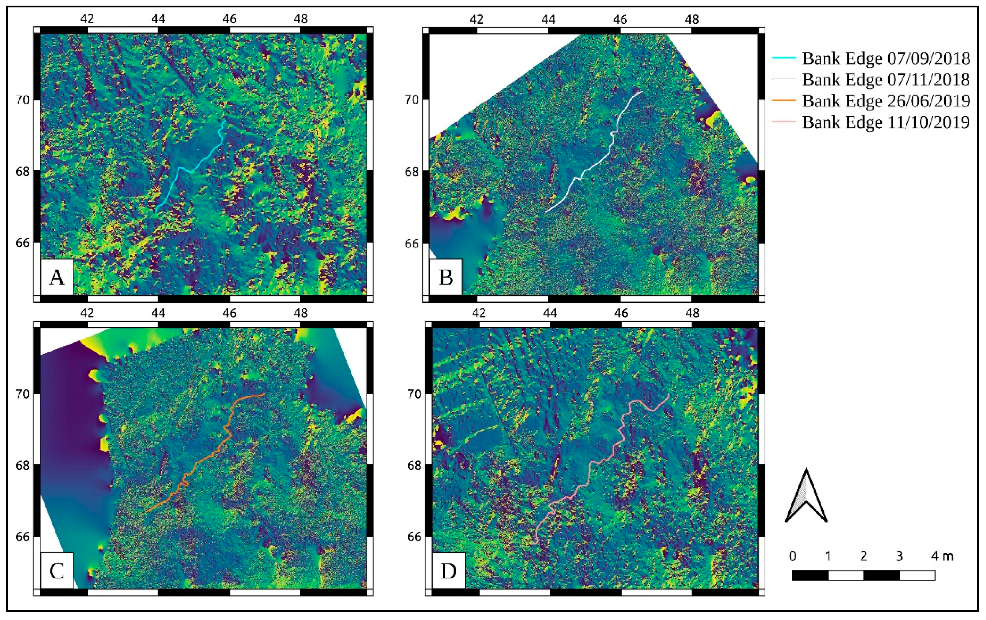
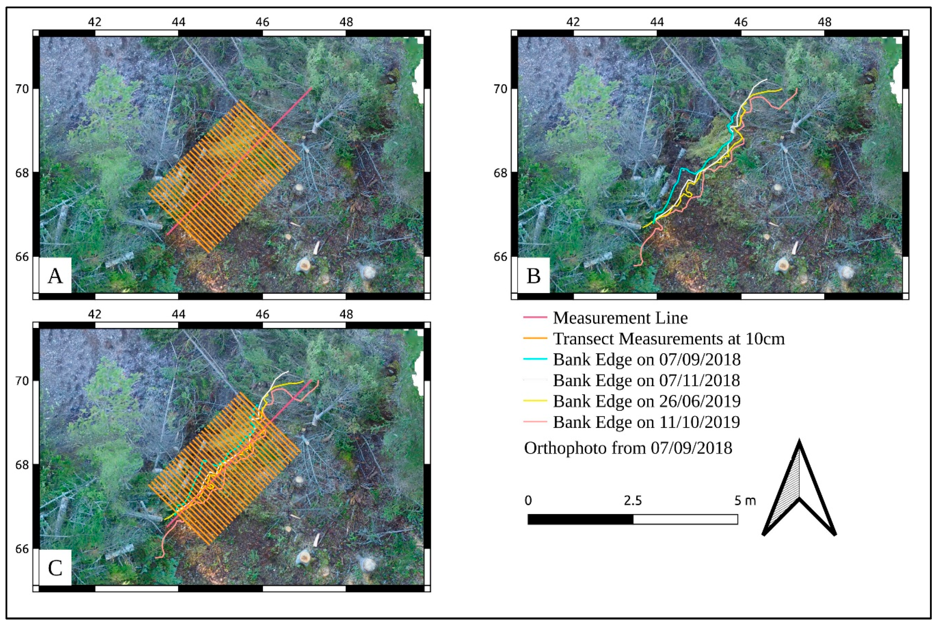
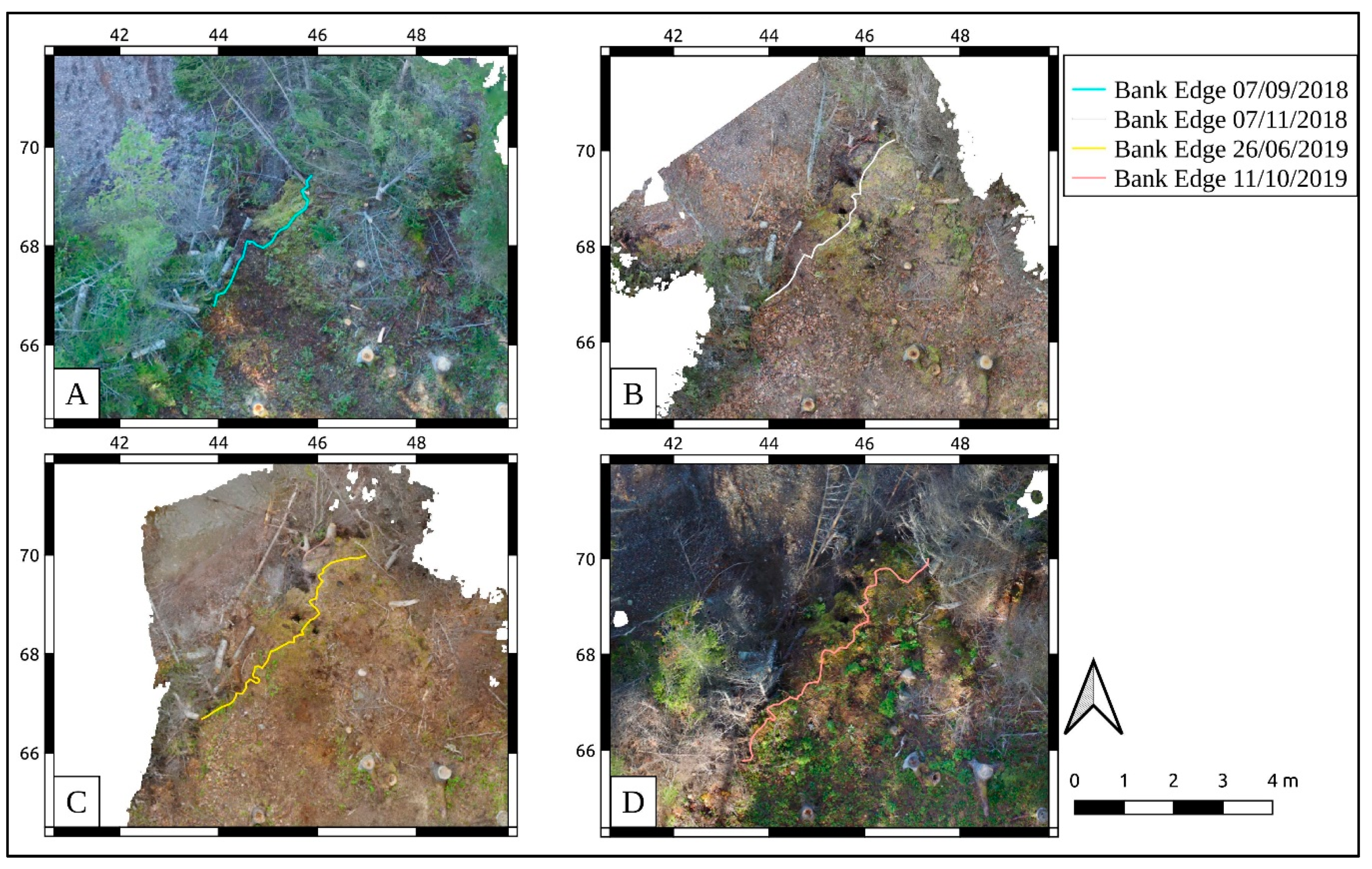
3.1. Bank Edge Erosion
3.2. Diachronic Analysis and Spatial Averages
4. Discussion
4.1. Regional Implications
4.2. Comparison with the Kuibyshev and Stânca-Costești Reservoirs
4.3. Vegetation and Bank Deterioration
5. Conclusions
Author Contributions
Funding
Acknowledgments
Conflicts of Interest
References
- Agapiou, A.; Lysandrou, V.; Sarris, A.; Papadopoulos, N.; Hadjimitsis, D.G. Fusion of Satellite Multispectral Images Based on Ground-Penetrating Radar (GPR) Data for the Investigation of Buried Concealed Archaeological Remains. Geosciences 2017, 7, 40. [Google Scholar] [CrossRef]
- O’Rourke, M.J.E. Risk and value: Grounded visualization methods and the assessment of cultural landscape vulnerability in the Canadian Arctic. World Archaeol. 2018, 50, 620–638. [Google Scholar] [CrossRef]
- Nicu, I.C. Application of analytic hierarchy process, frequency ratio, and statistical index to landslide susceptibility: An approach to endangered cultural heritage. Environ. Earth Sci. 2018, 77, 1–16. [Google Scholar] [CrossRef]
- Asandulesei, A.; Tencariu, F.A.; Nicu, I.C. Pars pro toto—Remote Sensing Data for the Reconstruction of a Rounded Chalcolithic Site from NE Romania: The Case of Ripiceni—Holm Settlement (Cucuteni Culture). Remote Sens. 2020, 12, 887. [Google Scholar] [CrossRef]
- Usmanov, B.; Nicu, I.C.; Gainullin, I.; Khomyakov, P. Monitoring and assessing the destruction of archaeological sites from Kuibyshev reservoir coastline, Tatarstan Republic, Russian Federation. A case study. J. Coast. Conserv. 2018, 22, 417–429. [Google Scholar] [CrossRef]
- Nicu, I.C.; Usmanov, B.; Gainullin, I.; Galimova, M. Shoreline Dynamics and Evaluation of Cultural Heritage Sites on the Shores of Large Reservoirs: Kuibyshev Reservoir, Russian Federation. Water 2019, 11, 591. [Google Scholar] [CrossRef]
- Nicu, I.C.; Asăndulesei, A. GIS-based evaluation of diagnostic areas in landslide susceptibility analysis of Bahluieț River Basin (Moldavian Plateau, NE Romania). Are Neolithic sites in danger? Geomorphology 2018, 314, 27–41. [Google Scholar] [CrossRef]
- Nicu, I.C. Natural risk assessment and mitigation of cultural heritage sites in North-eastern Romania (Valea Oii river basin). Area 2019, 51, 142–154. [Google Scholar] [CrossRef]
- Kincey, M.; Gerrard, C.; Warburton, J. Quantifying erosion of ‘at risk’ archaeological sites using repeat terrestrial laser scanning. J. Archaeol. Sci. Rep. 2017, 12, 405–424. [Google Scholar] [CrossRef]
- Mineo, S.; Pappalardo, G. Sustainable Fruition of Cultural Heritage in Areas Affected by Rockfalls. Sustainability 2020, 12, 296. [Google Scholar] [CrossRef]
- Hu, X.; Hu, K.; Tang, J.; You, Y.; Wu, C. Assessment of debris-flow potential dangers in the Jiuzhaigou Valley following the August 8, 2017, Jiuzhaigou earthquake, western China. Eng. Geol. 2019, 256, 57–66. [Google Scholar] [CrossRef]
- Wang, J.-J. Large-scale Debris Flow Disasters: Hazard-Risk-Vulnerability Analysis Approach in Taiwan. Conserv. Manag. Archa. 2016, 18, 449–463. [Google Scholar] [CrossRef]
- Kropáček, J.; Neckel, N.; Tyrna, B.; Holzer, N.; Hovden, A.; Gourmelen, N.; Schneider, C.; Buchroithner, M.; Hochschild, V. Repeated glacial lake outburst flood threatening the oldest Buddhist monastery in north-western Nepal. Nat. Hazards Earth Syst. Sci. 2015, 15, 2425–2437. [Google Scholar] [CrossRef]
- Nicu, I.C.; Stalsberg, K.; Rubensdotter, L.; Martens, V.V.; Flyen, A.-C. Coastal Erosion Affecting Cultural Heritage in Svalbard. A Case Study in Hiorthhamn (Adventfjorden)—An Abandoned Mining Settlement. Sustainability 2020, 12, 2306. [Google Scholar] [CrossRef]
- Kamran, M. Role of cultural heritage in promoting the resilience of linear/critical infrastructure system with the enhancement of economic dimension of resilience: A critical review. Int. J. Constr. Manag. 2020. [Google Scholar] [CrossRef]
- Nicu, I.C.; Stoleriu, C.C. Land use changes and dynamics over the last century around churches of Moldavia, Bukovina, Northern Romania—Challenges and future perspectives. Habitat Int. 2019, 88, 101979. [Google Scholar] [CrossRef]
- Kajihara, H.; Zhang, S.; You, W.; Min, Q. Concerns and Opportunities around Cultural Heritage in East Asian Globally Important Agricultural Heritage Systems (GIAHS). Sustainability 2018, 10, 1235. [Google Scholar] [CrossRef]
- Cozzolino, M.; Di Giovanni, E.; Mauriello, P.; Piro, S.; Zamuner, D. Management of Cultural Heritage: Contribution of Applied Geophysics. In Geophysical Methods for Cultural Heritage Management; Springer: Cham, Switzerland, 2018; pp. 1–4. [Google Scholar] [CrossRef]
- Amit-Cohen, I.; Sofer, M. Cultural heritage and its economic potential in rural society: The case of the kibbutzim in Israel. Land Use Policy 2016, 57, 368–376. [Google Scholar] [CrossRef]
- O’Rourke, M.J.E. Archaeological Site Vulnerability Modelling: The Influence of High Impact Storm Events on Models of Shoreline Erosion in the Western Canadian Arctic. Open Archaeol. 2017, 3, 1–16. [Google Scholar] [CrossRef]
- Asăndulesei, A. Inside a Cucuteni Settlement: Remote Sensing Techniques for Documenting an Unexplored Eneolithic Site from Northeastern Romania. Remote Sens. 2017, 9, 41. [Google Scholar] [CrossRef]
- Hemmelder, S.; Marra, W.; Markies, H.; De Jong, S.M. Monitoring river morphology & bank erosion using UAV imagery—A case study of the river Buëch, Hautes-Alpes, France. Int. J. Appl. Earth Obs. Geoinf. 2018, 73, 428–437. [Google Scholar] [CrossRef]
- Lee, G.; Choi, M.; Yu, W.; Jung, K. Creation of river terrain data using region growing method based on point cloud data from UAV photography. Quatern. Int. 2019, 519, 255–262. [Google Scholar] [CrossRef]
- Hamilton, S.; Stephenson, J. UAV (drone) aerial photography and photogrammetry and its utility for archaeological site documentation. Ont. Assoc. Prof. Archaeol. 2017, 2. [Google Scholar] [CrossRef]
- Howland, M.D.; Jones, I.W.N.; Najjar, M.; Levy, T.E. Quantifying the effects of erosion on archaeological sites with low-altitude aerial photography, structure from motion, and GIS: A case study from southern Jordan. J. Archaeol. Sci. 2018, 90, 62–70. [Google Scholar] [CrossRef]
- Forte, M. 3D Archaeology—New Perspectives and Challenges—The Example of Çatalhöyük. J. East. Mediterr. Archaeol. Herit. Stud. 2014, 2. [Google Scholar] [CrossRef]
- Haukass, C.; Hodgetts, L. The Untapped Potential of Low-Cost Photogrammetry in Community-Based Archaeology and Heritage. J. Community Archaeol. Herit. 2016, 3, 40–56. [Google Scholar] [CrossRef]
- Verhoeven, G. Taking computer vision aloft—Archaeological three-dimensional reconstructions from aerial photographs with photoscan. Archaeol. Prospect. 2011, 18, 67–73. [Google Scholar] [CrossRef]
- Nikolakopoulus, K.; Soura, K.; Koukouvelas, I.; Argyropoulos, N. UAV vs. classical aerial photogrammetry for archaeological studies. J. Archaeol. Sci. Rep. 2017, 14, 758–773. [Google Scholar] [CrossRef]
- Thomas, H. A methodology for combining terrestrial and aerial photographs to create high-resolution photogrammetric models of large-scale archaeological sites: A case study for Methone, Greece. J. Archaeol. Sci. Rep. 2017, 16, 27–33. [Google Scholar] [CrossRef]
- Probst, A.; Gatziolis, D.; Strigul, N. Intercomparison of photogrammetry software for three dimensional vegetation modelling. R. Soc. Open Sci. 2018, 5, 172192. [Google Scholar] [CrossRef] [PubMed]
- Heng, B.C.P.; Chandler, J.H.; Armstrong, A. Applying close range digital photogrammetry in soil erosion studies. Photogramm. Rec. 2010, 25, 240–265. [Google Scholar] [CrossRef]
- Jugie, M.; Gob, F.; Virmoux, C.; Brunstein, D.; Tamisier, V.; Le Coeur, C.; Grancher, D. Characterizing and quantifying the discontinuous bank erosion of a small low energy river using Structure-from-Motion Photogrammetry and erosion pins. J. Hydrol. 2018, 563, 418–434. [Google Scholar] [CrossRef]
- Magnani, M.; Douglass, M.; Schroder, W.; Reeves, J.; Braun, D.R. The Digital Revolution to Come: Photogrammetry in Archaeological Practice. Am. Antiq. 2020, 1–24. [Google Scholar] [CrossRef]
- Lazzari, M.; Gioia, D. UAV images and historical aerial-photos for geomorphological analysis and hillslope evolution of the Uggiano medieval archaeological site (Basilicata, southern Italy). Geomat. Nat. Hazards Risk 2017, 8, 104–119. [Google Scholar] [CrossRef]
- Zimmer, B.W.; Liutkus-Pierce, C.; Marshall, S.T.; Hatala, K.G.; Metallo, A.; Rossi, V. Using differential structure-from-motion photogrammetry to quantify erosion at the Engare Sero footprint site, Tanzania. Quat. Sci. Rev. 2018, 198, 226–241. [Google Scholar] [CrossRef]
- Fujii, Y.; Fodde, E.; Watanabe, K.; Murakami, K. Digital photogrammetry for the documentation of structural damage in earthen archaeological sites: The case of Ajina Tepa, Tajikistan. Eng. Geol. 2009, 105, 124–133. [Google Scholar] [CrossRef]
- Scott, H. Archaeological Predictive Modelling in the Boreal Forest: No Easy Answers. Can. J. Archaeol. 2000, 24, 41–76. [Google Scholar]
- Zheng, F.; Wackrow, R.; Meng, F.-R.; Lobb, D.; Li, S. Assessing the Accuracy and Feasibility of Using Close-Range Photogrammetry to Measure Channelized Erosion with a Consumer-Grade Camera. Remote Sens. 2020, 12, 1706. [Google Scholar] [CrossRef]
- Lantuit, H.; Pollard, W.H. Fifty years of coastal erosion and retrogressive thaw slump activity on Herschel Island, south Beaufort Sea, Yukon Territory, Canada. Geomorphology 2008, 95, 84–102. [Google Scholar] [CrossRef]
- Radosavljevic, B.; Lantuit, H.; Pollard, W.; Overduin, P.; Couture, N.; Sachs, T.; Helm, V.; Fritz, M. Erosion and Flooding—Threats to Coastal Infrastructure in the Arctic: A Case Study from Herschel Island, Yukon Territory, Canada. Estuaries Coasts 2016, 39, 900–915. [Google Scholar] [CrossRef]
- Irrgang, A.M.; Lantuit, H.; Gordon, R.R.; Piskor, A.; Manson, G.K. Impacts of past and future coastal changes on the Yukon coast—Threats for cultural sites, infrastructure, and travel routes. Arct. Sci. 2019, 5, 107–126. [Google Scholar] [CrossRef]
- Westley, K.; Bell, T.; Renouf, M.A.P.; Tarasov, L. Impact Assessment of Current and Future Sea-Level Change on Coastal Archaeological Resources—Illustrated Examples from Northern Newfoundland. J. Isl. Coast. Archaeol. 2011, 6, 351–374. [Google Scholar] [CrossRef]
- Ebert, J.; Camilli, E.; Wandsnider, L. Environmental Impact Research Program: Reservoir Bank Erosion and Cultural Resources: Experiments in Mapping and Predicting the Erosion of Archeological Sediments at Reservoirs along the Middle Missouri River with Sequential Historical Aerial Photographs. 1989, p. 129. Available online: https://apps.dtic.mil/sti/pdfs/ADA212709.pdf (accessed on 3 August 2020).
- Gatto, L.W.; Doe, W.W., III. Bank conditions and erosion along selected reservoirs. Environ. Geol. Water Sci. 1987, 9, 143–154. [Google Scholar] [CrossRef]
- GRASS Development Team. Geographic Resources Analysis Support System (GRASS GIS) Software, Version 7.2. Available online: https://grass.osgeo.org (accessed on 8 September 2020).
- Solem, D.-Ø.E. Two New Ways of Documenting Miniature Incisions Using a Combination of Image-Based Modelling and Reflectance Transformation Imaging. Remote Sens. 2020, 12, 1626. [Google Scholar] [CrossRef]
- McLean, L. Summary of Archaeological Research Performed by Laurie McLean/Consulting Archaeologist in 2017; Annual Archaeology Review 2017; Provincial Archaeology Office: St. John’s, NL, Canada, 2018; pp. 184–197. [Google Scholar]
- Marshall, I. A History and Ethnography of the Beothuk; McGill-Queens University Press: London, UK, 1996. [Google Scholar]
- Schwarz, F.; Hutchings, C. Archaeological Excavations at Sabbath Point (DeBd-08), July 2018, Red Indian Lake, Newfoundland; Provincial Archaeology Office: St. John’s, NL, Canada, 2018. [Google Scholar]
- McLean, L. Partial Excavation of a Beothuk House Pit at Sabbath Point (DeBd-08), Red Indian Lake; Provincial Archaeology Office: St. John’s, NL, Canada, 2018. [Google Scholar]
- Holly, D.; Wolff, C.J.; Samuels, A.; Yakabowskas, D.; Illenberg, M. Continuing Excavations at Sabbath Point (DeBd-08), Red Indian Lake, Newfoundland; Annual Archaeology Review 2019; Provincial Archaeology Office: St. John’s, NL, Canada, 2020; pp. 121–132. [Google Scholar]
- Howley, J.P. The Beothucks or Red Indians: The Aboriginal Inhabitants of Newfoundland; Coles Publishing Company: Toronto, ON, Canada, 1915. [Google Scholar]
- Marshall, I. Beothuk and Micmac: Re-examining Relationships. Acadiensis 1988, 17, 52–82. [Google Scholar]
- Aylward, C.; Joe, M. Beothuk and Mi’kmaq: An interview with Chief Mi’sel Joe. In Tracing Ochre: Changing Perspectives on the Beothuk; Polack, F., Ed.; University of Toronto Press: Toronto, ON, Canada, 2018. [Google Scholar]
- Devereux, H. A Preliminary Report on the Indian Point Site, a Stratified Beothuk Site; Provincial Archaeology Office: St. John’s, NL, Canada, 1970. [Google Scholar]
- McLean, L. Salvage Excavation of Groswater Palaeoeskimo Features at Aspen Island-2 (DfAw-05); Provincial Archaeology Office: St. John’s, NL, Canada, 2016. [Google Scholar]
- McLean, L. Final Report for Archaeological Salvage Excavations at Boom Island (DfAw-03), and Aspen Island-2 (DfAw-05), on the Exploits River Newfoundland; Provincial Archaeology Office: St. John’s, NL, Canada, 2016. [Google Scholar]
- Hull, S. Provincial Archaeology Site Database 2018. Available online: https://www.gov.nl.ca/tcar/artsheritage/culture/archaeology/provincial-archaeology-office/ (accessed on 10 April 2020).
- Smith, J.S. Eastern Red Indian Lake Basin, Central Newfoundland: Surficial and Ice-Flow Mapping Results. Report 13-1; Current Research, Newfoundland and Labrador Department of Natural Resources, Geological Survey; 2013; pp. 67–81. Available online: https://www.gov.nl.ca/nr/files/mines-geoscience-publications-currentresearch-2013-smith-2013.pdf (accessed on 14 July 2020).
- Wilton, D. NI 43-101 Technical Report on the Central Newfoundland Regional Gold Project, Central Newfoundland, NL, Canada. 2017, p. 90. Available online: https://www.antlergold.com/files/CheckCode.do_.pdf (accessed on 3 August 2020).
- Schwarz, F. Archaeological Investigations in the Exploits Basin; Provincial Archaeology Office: St. John’s, NL, Canada, 1992. [Google Scholar]
- Schwarz, F. Archaeological Monitoring of Brushcutting Activities at Six Beothuk Archaeological Sites along the Exploits River; Provincial Archaeology Office: St. John’s, NL, Canada, 2011. [Google Scholar]
- Williamson, J. Photogrammetric Surveys in the Exploits River Valley; Annual Archaeology Review 2019; Provincial Archaeology Office: St. John’s, NL, Canada, 2020; pp. 227–232. [Google Scholar]
- Locke, D. Field Notes; Provincial Archaeology Office: St. John’s, NL, Canada.
- Pollard-Belsheim, A.; Storey, M.; Robinson, C.; Bell, T. The CARRA project: Developing tools to help heritage managers identify and respond to coastal hazard impacts on archaeological resources. In 2014 Oceans—St. John’s; Provincial Archaeology Office: St. John’s, NL, Canada, 2014. [Google Scholar] [CrossRef]
- Holly, D.H., Jr.; Erwin, J.C. Terra Incognita, still: Archaeological investigations in the interior of the Island of Newfoundland. Archaeol. East. N. Am. 2009, 37, 65–84. [Google Scholar]
- Erwin, J.; Crompton, A.; Bolli, M. Sabbath Point (DeBd-08) Unmanned Aerial Vehicle (UAV) Mapping Project; Field Season Reports; Provincial Archaeology Office: St. John’s, NL, Canada, 2017; pp. 54–60. [Google Scholar]
- Chatzifoti, O. On the Popularization of Digital Close-Range Photogrammetry: A Handbook for New Users. Master’s Thesis, National University of Athens, Athens, Greece, 2015. [Google Scholar]
- Ahmed, N.; Carter, M.; Ferris, N. Sustainable archaeology through progressive assembly 3D digitization. World Archaeol. 2014, 46, 137–154. [Google Scholar] [CrossRef]
- MicMac ENSG. Available online: https://micmac.ensg.eu/index.php/Accueil (accessed on 8 September 2020).
- Agisoft LLC Agisoft Metashape User Manual, Professional Edition, Version 1.5 2019. Available online: https://www.agisoft.com/pdf/metashape-pro_1_6_en.pdf (accessed on 2 April 2020).
- De Felice, G. The New Trend of 3D Archaeology is...Going 2D! In CAA2015. Keep the Revolution Going: Proceedings of the 43rd Annual Conference on Computer Application and Quantitative Methods in Archaeology; Campana, S., Scopigno, R., Carpientiero, G., Cirillo, M., Eds.; Archaeopress: Oxford, UK, 2016; pp. 363–368. [Google Scholar]


© 2020 by the authors. Licensee MDPI, Basel, Switzerland. This article is an open access article distributed under the terms and conditions of the Creative Commons Attribution (CC BY) license (http://creativecommons.org/licenses/by/4.0/).
Share and Cite
Williamson, J.; Nicu, I.C. Photogrammetric Measurement of Erosion at the Sabbath Point Beothuk Site in Central Newfoundland, Canada. Sustainability 2020, 12, 7555. https://doi.org/10.3390/su12187555
Williamson J, Nicu IC. Photogrammetric Measurement of Erosion at the Sabbath Point Beothuk Site in Central Newfoundland, Canada. Sustainability. 2020; 12(18):7555. https://doi.org/10.3390/su12187555
Chicago/Turabian StyleWilliamson, James, and Ionut Cristi Nicu. 2020. "Photogrammetric Measurement of Erosion at the Sabbath Point Beothuk Site in Central Newfoundland, Canada" Sustainability 12, no. 18: 7555. https://doi.org/10.3390/su12187555
APA StyleWilliamson, J., & Nicu, I. C. (2020). Photogrammetric Measurement of Erosion at the Sabbath Point Beothuk Site in Central Newfoundland, Canada. Sustainability, 12(18), 7555. https://doi.org/10.3390/su12187555