Shared Space and Pedestrian Safety: Empirical Evidence from Pedestrian Priority Street Projects in Seoul, Korea


Abstract
:1. Introduction
2. Literature Review
2.1. The Shared Space Concept and PPS Project
2.2. Optical Illusions to Induce Deceleration
3. Materials and Methods
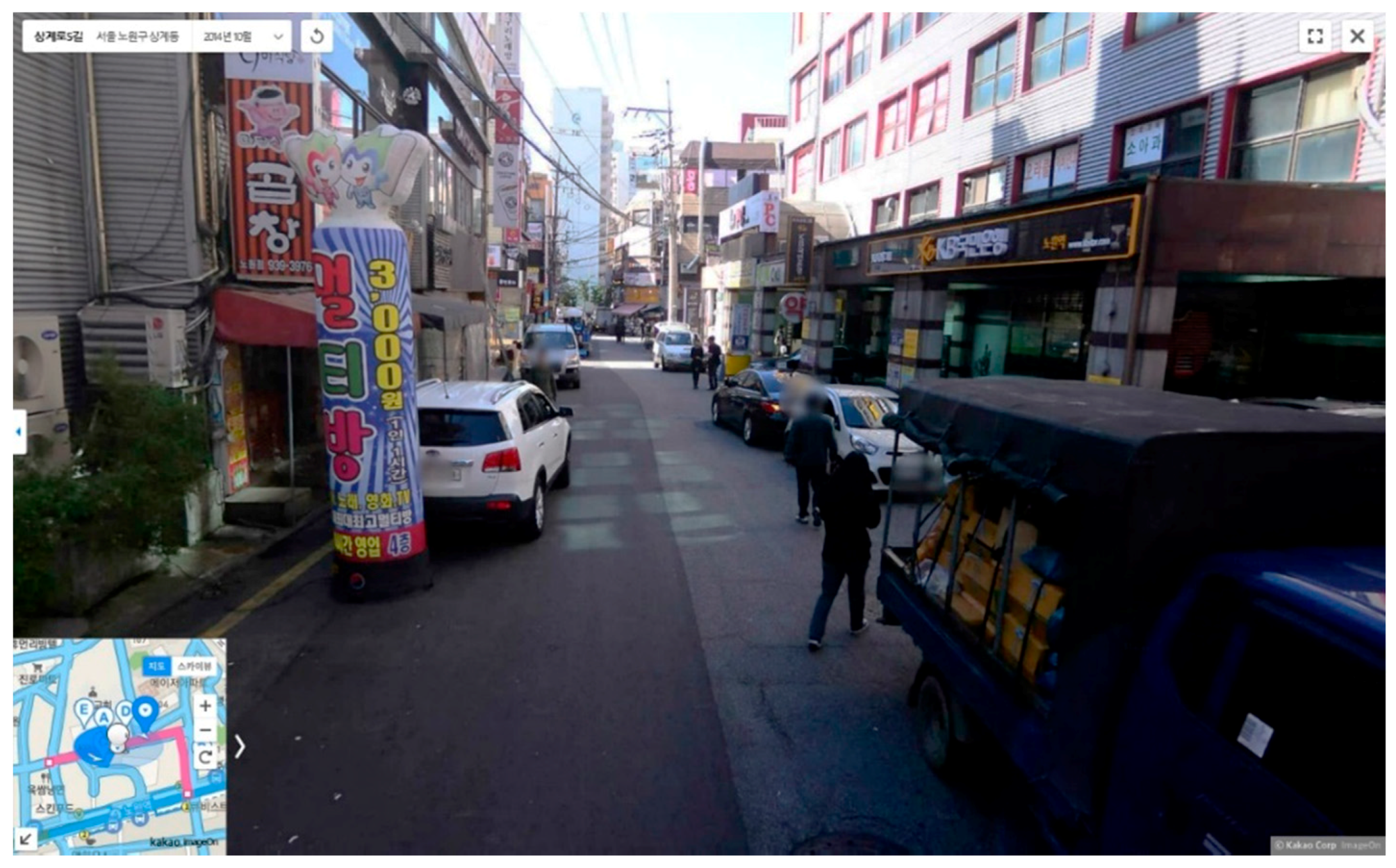
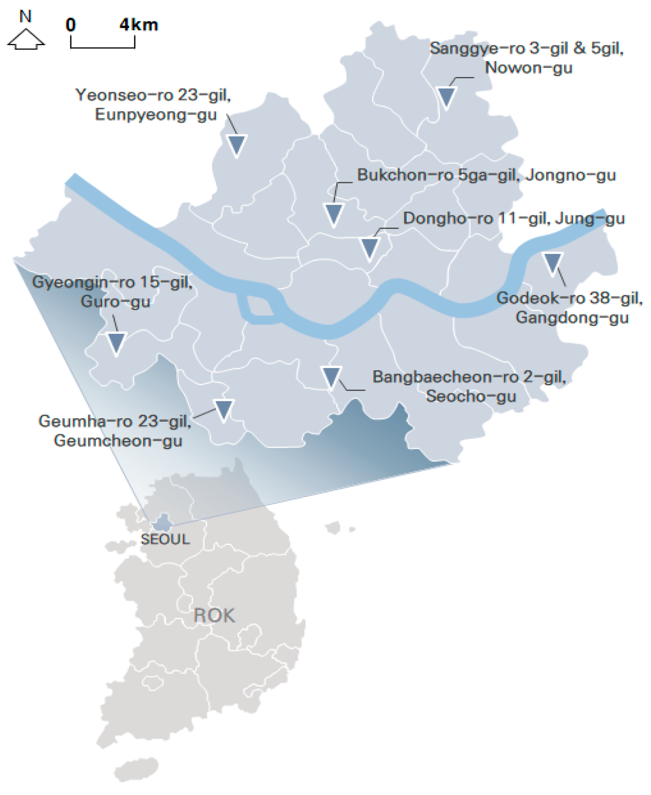
3.1. Study Area
3.2. Data Collection
3.3. Methods of Analysis
3.3.1. Dependent Variables
3.3.2. Independent Variables
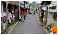
- VS-A: Stamped asphalt pavement covered the entire width of the street and there were no suggestions at the roadside of an exclusively pedestrian zone. This concept was interpreted to intend a genuine coexistence of pedestrians and vehicles.
- VS-B: Stamped asphalt pavement covered the entire width of the street, and there was some suggestion at the roadside of a pedestrian zone. This was interpreted as intending to protect a minimum area for pedestrians, while pursuing user coexistence.
- VS-C: Stamped asphalt pavement covered just a part of the street, which implied that pedestrians should walk within the paved area. This was interpreted as not pursuing coexistence.
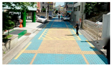
- DC-A: The lines and surface designs visually impacted drivers by giving the appearance that the street was segmented. We expected that the transverse design would trigger deceleration.
- DC-B: There were some transverse design elements, but they were relatively few; a weaker effect than that of DC-A was expected.
- DC-C: There was no transverse design at the study site; therefore, no segmenting effect was expected.
3.3.3. Statistical Analysis
4. Results
4.1. Design Type Classification
4.2. Before and After Comparisons of Speed by Paving Design Type
4.3. Multiple Regression Results on Paving Design Types
4.3.1. Results by VS Type
4.3.2. Results by DC Type
5. Conclusions and Policy Recommendations
Author Contributions
Funding
Acknowledgments
Conflicts of Interest
References
- Çelik, Z.; Favro, D.; Ingersoll, R. Streets: Critical Perspectives on Public Space, 1st ed.; University of California Press: Berkeley, CA, USA, 1994. [Google Scholar]
- Hass-Klau, C. The Pedestrian and the City, 1st ed.; Routledge: New York, NY, USA, 2014. [Google Scholar]
- Jacobs, A.B. Great Streets, 1st ed.; The MIT Press: Cambridge, MA, USA, 1993. [Google Scholar]
- Farr, D. Sustainable Urbanism: Urban Design with Nature; John Wiley & Sons: Hoboken, NJ, USA, 2008. [Google Scholar]
- Frumkin, H.; Frank, L.; Jackson, R.J. Urban Sprawl and Public Health: Designing, Planning, and Building for Healthy Communities; Island Press: Washington, DC, USA, 2004. [Google Scholar]
- Montgomery, C. Happy City: Transforming Our Lives Through Urban Design; Farrar, Straus and Giroux: New York, NY, USA, 2013. [Google Scholar]
- Shamsuddin, S.; Hassan, N.R.A.; Bilyamin, S.F.I. Walkable environment in increasing the livability of a city. Procedia Soc. Behav. Sci. 2012, 50, 167–178. [Google Scholar] [CrossRef]
- Jacobs, J. The Death and Life of American Cities; Modern Library Editions & Random House Inc.: New York, NY, USA, 1961. [Google Scholar]
- Mehta, V. The Street: A Quintessential Social Public Space; Routledge: New York, NY, USA, 2013. [Google Scholar]
- Speck, J. Walkable City; Farrar, Straus and Giroux: New York, NY, USA, 2012. [Google Scholar]
- Corbusier, L. The Athens Charter, 1st ed.; Eardley, A., Translator; Grossman: New York, NY, USA, 1973. [Google Scholar]
- Congress for the New Urbanism. Charter of the new urbanism. Bull. Sci. Technol. Soc. 2000, 20, 339–341. [Google Scholar] [CrossRef]
- Parolek, D.G.; Parolek, K.; Crawford, P.C. Form Based Codes: A Guide for Planners, Urban Designers, Municipalities, and Developers; John Wiley & Sons: Hoboken, NJ, USA, 2008. [Google Scholar]
- Speck, J. Walkable City Rules: 101 Steps to Making Better Places; Island Press: Washington, DC, USA, 2018. [Google Scholar]
- Seoul City Government. 2018 Road Statistics; Seoul City Government: Seoul, Korea, 2018; (In Korean).
- The Road Traffic Authority (KoROAD). Traffic Accident Analysis-Analysis of Pedestrian Traffic Accident Characteristics (2016-0229-058); KoROAD: Wonju, Korea, 2016; Volume 33, (In Korean). Available online: http://taas.koroad.or.kr/web/bdm/srs/selectStaticalReportsList.do?menuId=WEB_KMP_IDA_SRS_TAD (accessed on 19 June 2018).
- ITF. Casualties by age and road user. In ITF Transport Statistics (Database); 2019; Available online: https://doi.org/10.1787/3c6c57b0-en (accessed on 20 July 2019).
- The Korea Transport Institute (KOTI). 2017 National Transport Statistics: Domestic Sector, Sejong, Korea; KOTI: Sejong, Korea, 2018. (In Korean) [Google Scholar]
- Hamilton-Baillie, B. Shared space: Reconciling people, places and traffic. Built Environ. 2008, 34, 161–181. [Google Scholar] [CrossRef]
- Clarke, E. Shared space-the alternative approach to calming traffic. Traffic Eng. Control 2006, 47, 290–292. [Google Scholar]
- The Royal Borough of Kensington and Chelsea. The Exhibition Road Project Approval of Detailed Design; Cabinet: London, UK, 2009.
- Hamilton-Baillie, B. Towards shared space. Urban Des. Int. 2008, 13, 130–138. [Google Scholar] [CrossRef]
- Reid, S.; Kocak, N.; Hunt, L. DfT Shared Space Project Stage 1: Appraisal of Shared Space; C3783100; MVA Consultancy: Woking, UK, 2009; Available online: http://www.bv.transports.gouv.qc.ca/mono/1018971.pdf (accessed on 4 April 2019).
- Kaparias, I.; Bell, M.G.; Miri, A.; Chan, C.; Mount, B. Analysing the perceptions of pedestrians and drivers to shared space. Transp. Res. Part F Traffic Psychol. Behav. 2012, 15, 297–310. [Google Scholar] [CrossRef]
- Engwicht, D. Mental Speed Bumps: The Smarter Way to Tame Traffic, 1st ed.; Envirobook: Annandale, Australia, 2005. [Google Scholar]
- Adams, J. Risk, 1st ed.; UCL Press: London, UK, 1995. [Google Scholar]
- Adams, J. Management of the risks of transport. In Handbook of Risk Theory: Epistemology, Decision Theory, Ethics, and Social Implications of Risk, 1st ed.; Roeser, S., Hillerbrand, R., Sandin, P., Peterson, M., Eds.; Springer: Dordrecht, The Netherlands, 2012; pp. 239–264. [Google Scholar]
- Adams, J. Risk compensation in cities at risk. In Cities at Risk: Living with Perils in the 21st Century, 1st ed.; Advances in Natural and Technological Hazards Research Book Series; Joffe, H., Rossetto, T., Adams, J., Eds.; Springer: Dordrecht, The Netherlands, 2013; Volume 33, pp. 25–44. [Google Scholar]
- Kim, S.-N.; Oh, S.; Park, Y.-S. Status and Evaluation of 2014 Pedestrian Priority Street; Architecture and Urban Research Institute: Seoul, Korea, 2015; pp. 1–130. (In Korean) [Google Scholar]
- Cohen, A.S.; Hirsig, R. Feed Forward Programming of Car Drivers’ Eye Movement Behavior: A System Theoretical Approach. Final Technical Report Volume 1; Swiss Federal Institute of Technology, Department of Behavioral Science: Zurich, Canton of Zurich, Switzerland, 1980. [Google Scholar]
- Cohen, A.S.; Hirsig, R. Feed Forward Programming of Car Drivers’ Eye Movement Behavior: A System Theoretical Approach. Final Technical Report Volume 2; Swiss Federal Institute of Technology, Department of Behavioral Science: Zurich, Switzerland, 1980. [Google Scholar]
- Behrens, G. Sharing the Street: Shared Space in an American Context. Ph.D. Thesis, University of Washington, Washington, DC, USA, 2014. [Google Scholar]
- Ben-Joseph, E. Changing the residential street scene: Adapting the shared street (woonerf) concept to the suburban environment. J. Am. Plan. Assoc. 1995, 61, 504–515. [Google Scholar] [CrossRef]
- Frosch, C. Evaluation of Shared Space to Reduce Traffic Congestion: A Case Study on West Virginia University’s Downtown Campus. Master’s Thesis, Statler College of Engineering and Mineral Resources at West Virginia University, Morgantown, WV, USA, 2017. [Google Scholar]
- Biddulph, M. From car space to shared space. Ph.D. Thesis, Cardiff University, Cardiff, UK, 2014. [Google Scholar]
- Kaparias, I.; Bell, M.G.; Dong, W.; Sastrawinata, A.; Singh, A.; Wang, X.; Mount, B. Analysis of pedestrian-vehicle traffic conflicts in street designs with elements of shared space. Transp. Res. Rec. 2013, 2393, 21–30. [Google Scholar] [CrossRef]
- Kaparias, I.; Hirani, J.; Bell, M.G.; Mount, B. Pedestrian gap acceptance behavior in street designs with elements of shared space. Transp. Res. Rec. 2016, 2586, 17–27. [Google Scholar] [CrossRef]
- Karndacharuk, A.; Vasisht, P.; Prasad, M. Shared space evaluation: O’Connell Street, Auckland. In Proceedings of the Australasian Transport Research Forum 2015 Proceedings, Sydney, Australia, 30 September–2 October 2015. [Google Scholar]
- Karndacharuk, A.; Wilson, D.; Dunn, R. Analysis of pedestrian performance in shared-space environments. Transp. Res. Rec. 2013, 2393, 1–11. [Google Scholar] [CrossRef]
- Karndacharuk, A.; Wilson, D.J.; Dunn, R. A review of the evolution of shared (street) space concepts in urban environments. Transp. Rev. 2014, 34, 190–220. [Google Scholar] [CrossRef]
- Karndacharuk, A.; Wilson, D.J.; Dunn, R.C. Safety performance study of shared pedestrian and vehicle space in New Zealand. Transp. Res. Rec. 2014, 2464, 1–10. [Google Scholar] [CrossRef]
- Moody, S.; Melia, S. Shared space: Implications of Recent Research for Transport Policy; Working Paper; University of the West of England: Bristol, UK, 2011. [Google Scholar]
- Moody, S.; Melia, S. Shared space: Research, policy and problems. In Proceedings of the Institution of Civil Engineers-Transport; ICE, 2014; Available online: https://www.icevirtuallibrary.com/doi/full/10.1680/tran.12.00047 (accessed on 23 August 2019).
- Vasisht, P.; Karndacharuk, A. Auckland shared zones: Design solution for urban mobility in activity centres. In Proceedings of the 27th ARRB Conference, Melbourne, Victoria, Australia, 16–18 November 2016. [Google Scholar]
- Fwa, T.F. The Handbook of Highway Engineering, 1st ed.; CRC Press: Boca Raton, FL, USA, 2006. [Google Scholar]
- Kanzaki, N.; Ohmori, Y.; Ishimura, S. The use of interlocking block pavements for the reduction of traffic accidents. In Proceedings of the 2nd International Conference on Concrete Block Paving, Delft University of Technology, Delft, The Netherlands, 10–12 April 1984; pp. 200–206. [Google Scholar]
- Shackel, B.; Candy, C.C. Factors influencing the choice of concrete blocks as a pavement surface. In Proceedings of the 3rd International Conference on Concrete Block Paving, Auditorium Della Tecnica, Rome, Italy, 17–19 May 1988; pp. 78–85. [Google Scholar]
- Agent, K.R. Transverse Pavement Markings for Speed Control and Accident Reduction; Kentucky Transportation Center Research Report (539); Division of Research, Bureau of Highways, Department of Transportation: Frankfort, KY, USA, 1980.
- Ariën, C.; Brijs, K.; Ceulemans, W.; Jongen, E.; Daniels, S.; Brijs, T.; Wets, G. The effect of pavement markings on driving behavior in curves: A driving simulator study. In Proceedings of the Transportation Research Board 91st Annual Meeting, Washington, DC, USA, 22–26 January 2012; pp. 1–19. [Google Scholar]
- Ariën, C.; Brijs, K.; Vanroelen, G.; Ceulemans, W.; Jongen, E.M.; Daniels, S.; Brijs, T.; Wets, G. The effect of pavement markings on driving behaviour in curves: A simulator study. Ergonomics 2017, 60, 701–713. [Google Scholar] [CrossRef] [PubMed]
- Gates, T.; Qin, X.; Noyce, D. Effectiveness of experimental transverse-bar pavement marking as speed-reduction treatment on freeway curves. Transp. Res. Rec. 2008, 2056, 95–103. [Google Scholar] [CrossRef]
- Godley, S.T.; Triggs, T.J.; Fildes, B.N. Speed reduction mechanisms of transverse lines. Transp. Hum. Factors 2000, 2, 297–312. [Google Scholar] [CrossRef]
- Katz, B.J. Peripheral Transverse Pavement Markings for Speed Control. Ph.D. Thesis, Virginia Tech, Blacksburg, VA, USA, 2007. [Google Scholar]
- Boodlal, L.; Donnell, E.T.; Porter, R.J.; Garimella, D.; Le, T.; Croshaw, K.; Himes, S.; Kulis, P.N.; Wood, J. Factors Influencing Operating Speeds and Safety on Rural and Suburban Roads; FHWA-HRT-15-030; Federal Highway Administration, Turner-Fairbank Highway Research Center: McLean, VA, USA, 2015.
- Thaler, R.H.; Sunstein, C.R. Nudge: Improving Decisions About Health, Wealth, and Happiness; Penguin: New York, NY, USA, 2009. [Google Scholar]
- Zaidel, D.; Hakkert, A.-S.; Barkan, R. Rumble strips and paint stripes at a rural intersection. Transp. Res. Rec. 1986, 1069, 7–13. [Google Scholar]
- Chrysler, S.T.; Schrock, S.D. Field Evaluations and Driver Comprehension Studies of Horizontal Signing; FHWA/TX-05/0-4471-2; Texas Transportation Institute, Texas A & M University System: College Station, TX, USA, 2005. [Google Scholar]
- Kim, B.-J.; Shim, H.-B. Driver’s cognition of design elements and driving behavior in pedestrian priority road-focused on the case of Manguro 55gil, Jungnang-gu, Seoul, S. Korea. J. Urban Des. Inst. Korea 2018, 19, 73–84. (In Korean) [Google Scholar] [CrossRef]
- World Health Organization. Speed Management: A Road Safety Manual for Decision-Makers and Practitioners; Global Road Safety Partnership: Geneva, Switzerland, 2008. [Google Scholar]
- Gujarati, D.N. Basic Econometrics, 4th ed.; McGraw-Hill: Singapore, 2003. [Google Scholar]
- Government of Korea. Road Traffic Act. Article 8. 2011. Available online: http://www.law.go.kr/LSW/eng/engLsSc.do?menuId=2§ion=lawNm&query=Road+Traffic+Act&x=29&y=24#liBgcolor1 (accessed on 15 July 2019).

| Site Code | Street Name | Street Width (m) | Total Length (m) | Traffic Volume Per Hour 1 | Pedestrian Volume Per Hour 1 | Mean Speed (km/h) | |||
|---|---|---|---|---|---|---|---|---|---|
| Before | After | Before | After | Before | After | ||||
| 1 | Bukchon-ro 5ga-gil, Jongno-gu | 6.5 | 240 | 24 | 17 | 628 | 560 | 14.86 | 15.25 |
| 2 | Dongho-ro 11-gil, Jung-gu | 7.5 | 500 | 111 | 61 | 420 | 564 | 18.10 | 16.97 |
| 3 | Sanggye-ro 3-gil, Nowon-gu | 8.0 | 150 | 40 | 40 | 1700 | 1432 | 13.86 | 13.11 |
| 4 | Sanggye-ro 5-gil, Nowon-gu | 8.0 | 220 | 67 | 61 | 269 | 243 | 16.47 | 18.58 |
| 5 | Yeonseo-ro 23-gil, Eunpyeong-gu | 10.0 | 214 | 220 | 245 | 217 | 245 | 22.32 | 21.35 |
| 6 | Gyeongin-ro 15-gil, Guro-gu | 8.0 | 400 | 44 | 77 | 195 | 215 | 19.22 | 18.61 |
| 7 | Geumha-ro 23-gil, Geumcheon-gu | 10.0 | 420 | 227 | 223 | 233 | 273 | 23.69 | 22.84 |
| 8 | Bangbaecheon-ro 2-gil, Seocho-gu | 9.5 | 430 | 735 | 728 | 592 | 535 | 15.16 | 20.33 |
| 9 | Godeok-ro 38-gil, Gangdong-gu | 10.0 | 430 | 183 | 205 | 325 | 293 | 19.16 | 26.00 |
| Mean | 8.6 | 333.8 | 183 | 184 | 509 | 484 | 18.09 | 19.23 | |
| Paving Design | VS Type | DC Type | Paving Design | VS Type | DC Type |
|---|---|---|---|---|---|
 | A | C |  | A | B |
| Bukchon-ro 5ga-gil, Jongno-gu | Gyeongin-ro 15-gil, Guro-gu | ||||
 | B | A | 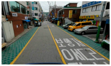 | C | C |
| Dongho-ro 11-gil, Jung-gu | Geumha-ro 23-gil, Geumcheon-gu | ||||
 | A | B |  | C | C |
| Sanggye-ro 3-gil, Nowon-gu | Bangbaecheon-ro 2-gil, Seocho-gu | ||||
 | B | B |  | C | C |
| Sanggye-ro 5-gil, Nowon-gu | Godeok-ro 38-gil, Gangdong-gu | ||||
 | A | B | |||
| Yeonseo-ro 23-gil, Eunpyeong-gu |
| Criteria | Type | Target Group | Control Group 1 | |||||||
|---|---|---|---|---|---|---|---|---|---|---|
| Number of Cases | Mean Speed (km/h) | Mean Speed (km/h) | ||||||||
| Before | After | Before | After | Change Rate (%) | t-Value | Before | After | Change Rate (%) | ||
| VS | A | 246 | 285 | 20.33 | 19.64 | −3.39 | 1.16 | 17.90 | 16.58 | −7.33 |
| B | 133 | 92 | 17.49 | 17.46 | 1.54 | −0.33 | 15.92 | 18.25 | 14.66 | |
| C | 858 | 867 | 17.49 | 21.82 | 24.76 | −11.37 *** | 18.86 | 21.67 | 14.87 | |
| DC | A | 83 | 46 | 18.10 | 16.97 | −6.24 | 0.90 | 18.57 | 23.23 | 25.13 |
| B | 278 | 318 | 19.99 | 19.67 | −1.60 | 0.58 | 17.08 | 15.07 | −11.76 | |
| C | 876 | 880 | 17.43 | 21.72 | 24.61 | −11.38 *** | 18.28 | 21.08 | 15.32 | |
| Variable | By VS Type | By DC Type | ||||
|---|---|---|---|---|---|---|
| B | t-Value | p-Value | B | t-Value | p-Value | |
| VS Types: “before implementation” is reference variable. | ||||||
| VS-A | −0.752 | −0.770 | 0.446 | |||
| VS-B | −0.359 | −0.276 | 0.784 | |||
| VS-C | 3.189 | 2.758 | 0.009 *** | |||
| DC Types: “before implementation” is reference variable. | ||||||
| DC-A | 1.202 | 0.653 | 0.517 | |||
| DC-B | −1.103 | −1.122 | 0.268 | |||
| DC-C | 2.171 | 2.260 | 0.029 ** | |||
| Time Slot: “evening” is reference variable. | ||||||
| Morning | 3.886 | 3.983 | 0.000 *** | 4.037 | 4.103 | 0.000 *** |
| Afternoon | −0.158 | −0.172 | 0.864 | 0.068 | −0.073 | 0.942 |
| Street width (m) | 1.470 | 3.708 | 0.001 *** | 1.887 | 4.853 | 0.000 *** |
| Distance to the closest intersection (m) | 0.023 | 0.420 | 0.676 | −0.001 | −0.022 | 0.983 |
| Traffic volume (vehicles/15 min) | −0.020 | −2.292 | 0.027 ** | −0.021 | −2.315 | 0.025 ** |
| Pedestrian volume (people/15 min) | −0.017 | −5.052 | 0.000 *** | −0.016 | −4.677 | 0.000 *** |
| Existence of speed bumps | 0.580 | 0.670 | 0.506 | 1.019 | 1.213 | 0.232 |
| (Constant) | 6.405 | 1.781 | 0.082 | 2.943 | 0.862 | 0.394 |
| Adjusted R2 | 0.71 | 0.70 | ||||
| D-W | 1.93 | 1.96 | ||||
| F | 13.70 | 13.42 | ||||
| Variable | By VS Type | By DC Type | ||||
|---|---|---|---|---|---|---|
| B | t-Value | p-Value | B | t-Value | p-Value | |
| VS Types: “VS-C” is reference variable. | ||||||
| VS-A | −7.200 | −3.041 | 0.007 *** | |||
| VS-B | −5.772 | −1.893 | 0.076 * | |||
| DC Types: “DC-C” is reference variable. | ||||||
| DC-A | 3.139 | 0.584 | 0.567 | |||
| DC-B | −3.694 | −2.162 | 0.045 ** | |||
| Time Slot: “evening” is reference variable. | ||||||
| Morning | 0.155 | 0.096 | 0.925 | 0.403 | 0.238 | 0.815 |
| Afternoon | 0.936 | 0611 | 0.550 | 0.901 | 0.566 | 0.579 |
| Street width (m) | 0.074 | 0.092 | 0.928 | 1.404 | 2.030 | 0.058 * |
| Distance to the closest intersection (m) | −0.177 | −1.634 | 0.121 | −0.294 | −2.251 | 0.038 ** |
| ∆ Traffic volume (vehicles/15 min) | 0.050 | 0.391 | 0.701 | 0.032 | 0.249 | 0.807 |
| ∆ Pedestrian volume (people/15 min) | −0.032 | −1.975 | 0.065 * | −0.039 | −2.181 | 0.044 ** |
| ∆ Number of speed bumps | −3.087 | −1.756 | 0.097 * | −0.641 | −0.258 | 0.800 |
| (Constant) | 7.953 | 0.990 | 0.336 | −4.758 | −0.766 | 0.454 |
| adjusted R2 | 0.34 | 0.29 | ||||
| D-W | 1.59 | 1.47 | ||||
| F | 2.50 | 2.19 | ||||
| Category | Strongly Agree/Agree | Neutral | Strongly Disagree/Disagree | n |
|---|---|---|---|---|
| 1. As a Pedestrian, I Feel the Vehicle Speed has Decreased. | ||||
| VS-A | 31% | 33% | 36% | 309 |
| VS-B | 38% | 20% | 41% | 206 |
| VS-C | 27% | 12% | 61% | 304 |
| 2. As a Pedestrian, I Feel the Risk of Collision with the Vehicle has been Reduced. | ||||
| VS-A | 31% | 36% | 33% | 309 |
| VS-B | 46% | 32% | 22% | 206 |
| VS-C | 28% | 31% | 41% | 304 |
| 3. As a Pedestrian, I Feel the Number of Vehicles Overtaking Pedestrians has Decreased. | ||||
| VS-A | 31% | 36% | 33% | 309 |
| VS-B | 48% | 31% | 21% | 206 |
| VS-C | 28% | 27% | 45% | 304 |
| Category | Strongly Agree/Agree | Neutral | Strongly Disagree/Disagree | n |
|---|---|---|---|---|
| 1. As a Pedestrian, I Feel the Vehicle Speed has Decreased. | ||||
| DC-A | 43% | 9% | 48% | 100 |
| DC-B | 28% | 32% | 40% | 313 |
| DC-C | 31% | 18% | 51% | 406 |
| 2. As a Pedestrian, I Feel the Risk of Collision with the Vehicle has been Reduced. | ||||
| DC-A | 53% | 33% | 14% | 100 |
| DC-B | 26% | 36% | 38% | 313 |
| DC-C | 34% | 31% | 35% | 406 |
| 3. As a Pedestrian, I Feel the Number of Vehicles Overtaking Pedestrians has Decreased. | ||||
| DC-A | 57% | 26% | 17% | 100 |
| DC-B | 26% | 39% | 36% | 313 |
| DC-C | 35% | 27% | 38% | 406 |
© 2019 by the authors. Licensee MDPI, Basel, Switzerland. This article is an open access article distributed under the terms and conditions of the Creative Commons Attribution (CC BY) license (http://creativecommons.org/licenses/by/4.0/).
Share and Cite
Lee, H.; Kim, S.-N. Shared Space and Pedestrian Safety: Empirical Evidence from Pedestrian Priority Street Projects in Seoul, Korea. Sustainability 2019, 11, 4645. https://doi.org/10.3390/su11174645
Lee H, Kim S-N. Shared Space and Pedestrian Safety: Empirical Evidence from Pedestrian Priority Street Projects in Seoul, Korea. Sustainability. 2019; 11(17):4645. https://doi.org/10.3390/su11174645
Chicago/Turabian StyleLee, Haeryung, and Seung-Nam Kim. 2019. "Shared Space and Pedestrian Safety: Empirical Evidence from Pedestrian Priority Street Projects in Seoul, Korea" Sustainability 11, no. 17: 4645. https://doi.org/10.3390/su11174645
APA StyleLee, H., & Kim, S.-N. (2019). Shared Space and Pedestrian Safety: Empirical Evidence from Pedestrian Priority Street Projects in Seoul, Korea. Sustainability, 11(17), 4645. https://doi.org/10.3390/su11174645