To present a suitable site selection landfill map, spatial analysis tools in GIS were used to prepare thirteen different criteria as layers covering the study area, with each criterion consisting of a database of a digital map prepared within GIS. All processed datasets used to input the AHP model of landfill dumpsite followed these principal steps:
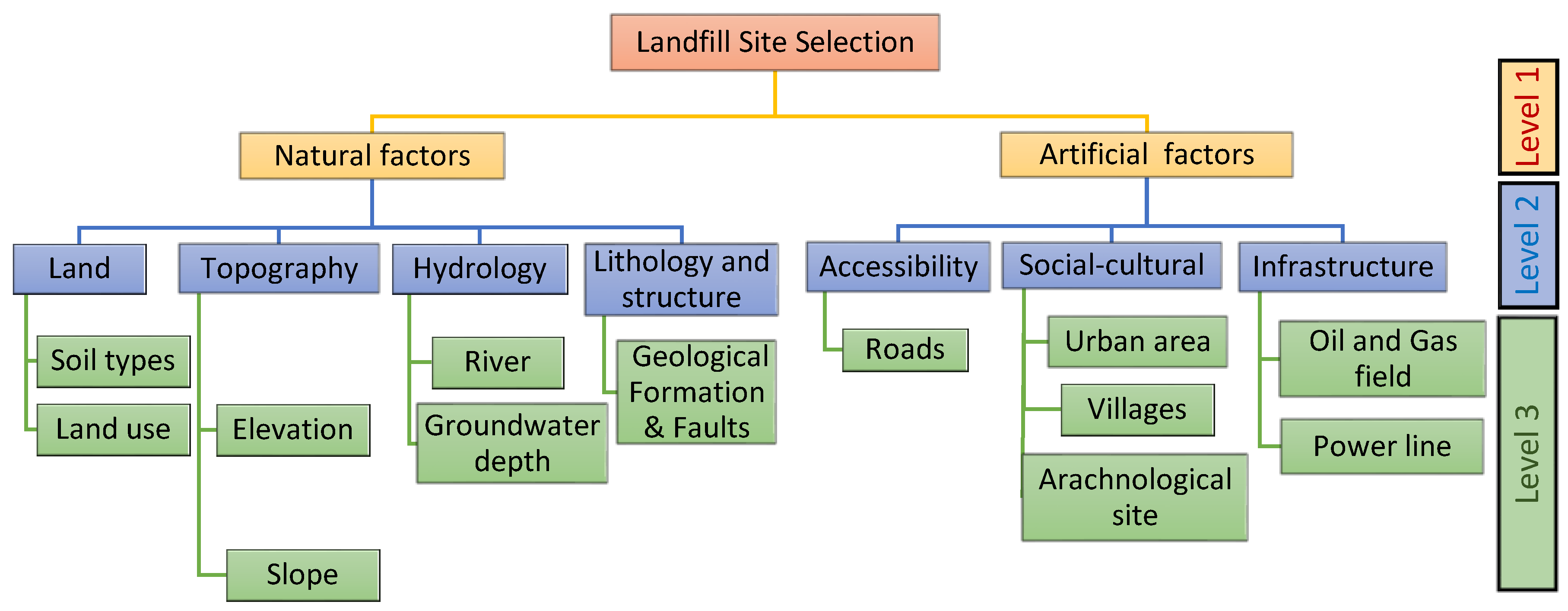
3.1. The Hierarchical Scheme for Landfill Siting
The hierarchical framework for decision-making was based on expert views in multi-criteria analysis, prior research and available information in the study area [
33]. The hierarchical scheme of the site selection involves three levels as presented in
Figure 2.
The first level in the proposed model represents identification of the factors affecting the potential landfill site model, which consists of two categories: natural environmental factors, and artificial factors. The second level contains six primary criteria: land, topographical, hydrological, geology, infrastructure, accessibility and social-cultural factors. The third level involves all thirteen criteria that were used in the present research to determine suitable sites as the optimum solution for landfill solid waste disposal.
The hierarchical scheme was designed according to the relations between each criterion and the decision process for landfill site selection.
The “river” criterion was adopted in order to protect surface water from organic, inorganic and microbial pollutants and contamination from leachate leaking from the solid waste landfill, which is a very common phenomenon in rapidly developing countries [
34,
35]. Distances from roads to the selected landfill location must ensure proximity to the road network with a view to facilitating transport and thus reducing the relative costs. Moreover, access to a landfill site should be adequate to ensure that the aesthetics of the region are not adversely affected [
16,
36]. The criterion of topography (elevation) was selected in respect of the risk of flooding in the area [
37]. Steep slopes would make it difficult to transport the waste to the site and cause leachate drainage into flat regions and water bodies that cause contamination, while slopes that are too flat would affect the runoff drainage [
16,
23,
38].
For the “urban area” criterion, an approximate distance of solid waste sites depends on many factors, such as governmental regulations and environment suggestions from scientists. Generally, the approximate distance should be appropriate for urban planning and potential future expansion, as well as ensuring impacts on public health, the aesthetic aspect of the city. Furthermore, a landfill site should be at a proper distance from the boundaries of urban regions due to the economic factors of the transport costs [
18,
39,
40,
41].
The “soil” criterion was used to preserve the study region from contamination by leachate transportation through the unsaturated zone within soil layers. The soil of the study area consists of four types of soil which are known as alluvial and recent deposits [
42,
43].
The “power lines” criterion was selected to prevent any danger to and from high voltage power lines and to ensure minimal disruption to the infrastructure near the solid waste site [
44]. The “archaeological” criterion is the national cultural heritage, which includes numerous archeological and historical sites. In the current study, the criteria “oil and gas field” were adopted to protect important infrastructure, which is considered the most valuable source of national wealth [
45,
46].
“Geological formations” describes the outcropped and subsurface lithology. In the current study, this criterion was adopted to protect the study area from geological hazards by understanding the engineering properties of the formations for settlement and other large structure building and by finding economic and valuable formations like groundwater and oil accumulation, together with raw material for cement, gypsum and aggregates [
42].
The “land use” criterion was adopted according to the land use classification and land specification due to priority of land use and the distance between the disposal site and factories, pasture and forests, also considering the cost of unused land and ownership of agriculture land [
5].
Groundwater ranges in depth from 19 to 280 m below the ground surface in most regions of the Sulaimaniyah Governorate. The landfill location should be located in an area with a deep groundwater depth in order to decrease the risk of leachate from solid waste and protect water aquifers from pollution [
18,
34].
3.2. Dataset Criteria Map
In this study, thirteen data sets obtained from international organizations and various government sources were used as input parameters for AHP modelling. The first source is available government data, including urban area, archaeological sites, power lines, oil and gas fields, villages, soil and geological formations. These digital data were converted into format files using GIS.
The river, road, and elevation data from the United States Geological Survey USGS Earth Explorer and the elevation map were downloaded as a digital elevation model that was converted to a slope map. The source of the data is presented in
Table 1.
Water level depth data was obtained from the Sulaymaniyah groundwater authority, and 235 wells were added to GIS using the spatial analysis tools “Kriging” to create a map of the groundwater table in the Sulaymaniyah Governorate. The land use classification was prepared using satellite data and processed by remote sensing software (ENVI 5.4).
3.4. Sub-Criteria Rating Values
Each criterion was classified into sub-criteria in this research and assigned a suitability rating value from zero to ten [
58]. Due to the associated legislation, limitations and regulations, the criteria and variables are determined and assessed for their suitability for the research region, together with experience, information from literature reviews and scientific experts in this field. This was done in order to collect more information about category priorities for the study area and to rate the categories’ importance in respect of solid waste site selection.
A number of steps were followed to evaluate the rating value for each criterion and sub-criteria using the GIS spatial analysis tools in a sequence (Buffer, Clip, Extract, Overlay, Proximity, Convert, Reclassify and Map Algebra). Sub-criteria buffer zone and rating values for the input layer are shown in
Table 3.
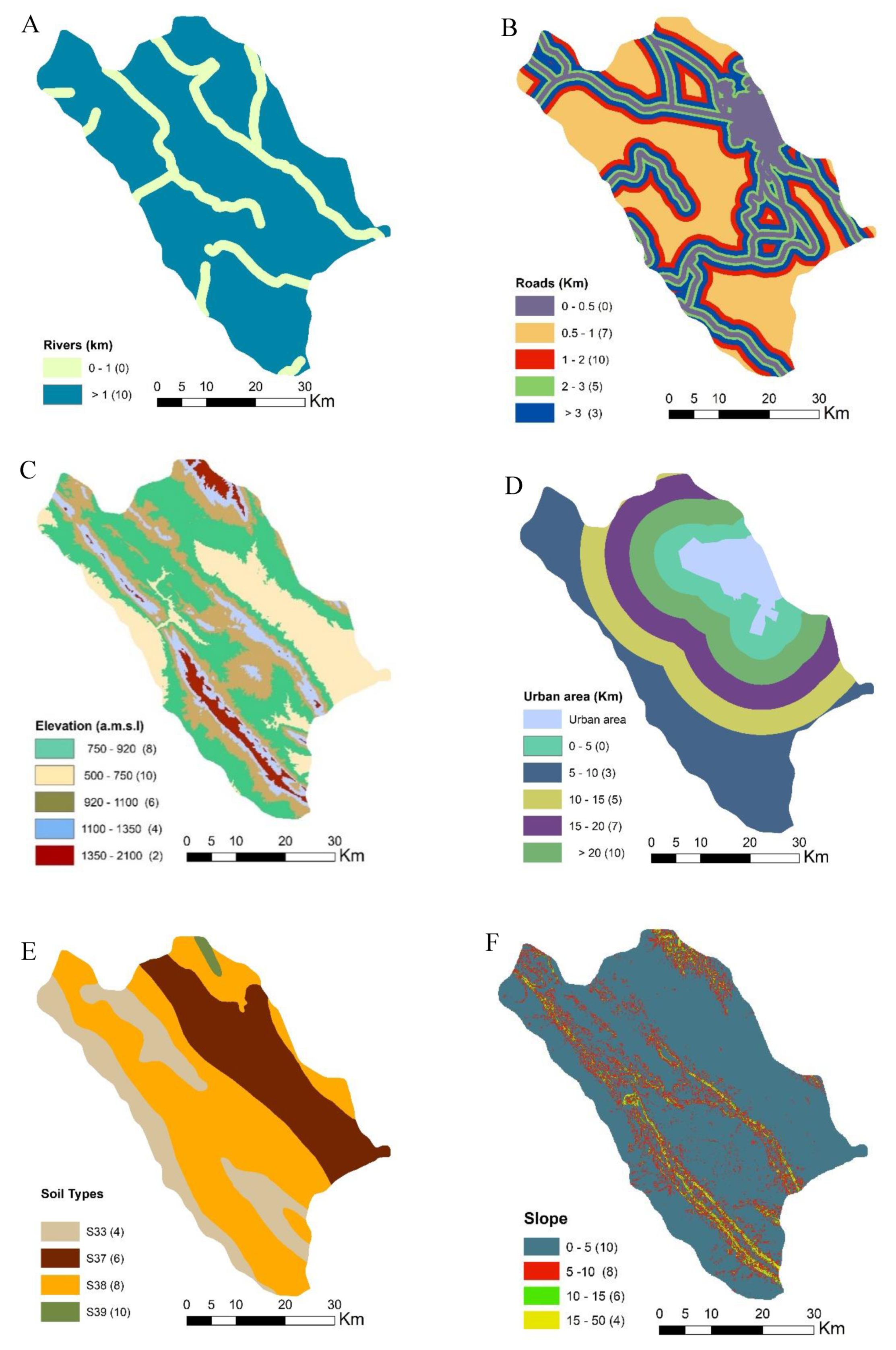
In this revise, a distance of less than 1000 m from the boundaries of a river was given a rating value of 0 to reduce the potential for river contamination from landfill, and a rating value of 10 was provided at distances higher than 1000 m (
Figure 3A). Main roads and highways were integrated into the “roads” criterion. The greatest score of 10 was allocated to buffer areas from roads to landfill locations of 1000–2000 m. Buffer zones of less than 500 m and those of more than 3000 m were given grades of 0 and 3, respectively. Buffer areas of 500–1000 m were allocated a grade of 7 depending on the aesthetic effects on the region, while buffer zones of 2000–3000 m were given a grade of 5 to reduce transportation costs (
Figure 3B).
For the elevation layer, the digital elevation model in the form of the raster elevation map was divided into five categories due to the study area altitude, whereby 1350–2100, 1100–1350, 920–1100, 750–920 and 500–750 above mean sea level (a.m.s.l.) were given ratings of 2, 4, 6, 8 and 10, respectively. In this research, appropriate elevations for the selection of landfill sites were given grading values of 8 and 10 (
Figure 3C).
The layer “urban area” criterion was classified into five categories. Buffer zones of more than 20 km were given the highest score of 10. Buffer zones of 15–20 km, 10–15 km, 5–10 km and less than 5 km were given the scores of 7, 5, 3 and 0, respectively (
Figure 3D). Cover soil in the Sulaimaniyah government is classified into four types of soil. These soil groups are (S33), consisting of Brown Soil, Medium and Shallow Phase over “Bakhtyary Gravel,” (S37), consisting of Chestnut Soil, Deep phase, (S38), consisting of Rough Broken and Stony Land, and (S39), defined as Rough Mountainous Land. These soil types were ratings of 4, 6, 8 and 10 respectively (
Figure 3E).
Four categories have been identified for Land Slope, less than 5°, 5–10°, 10–15° and 15–50°, and these were given ratings of 10, 8, 6 and 4 respectively. According to the literature, less than 5° is considered the best slope for landfill locations to avoid the transportation of waste leachate to adjacent areas (
Figure 3F).
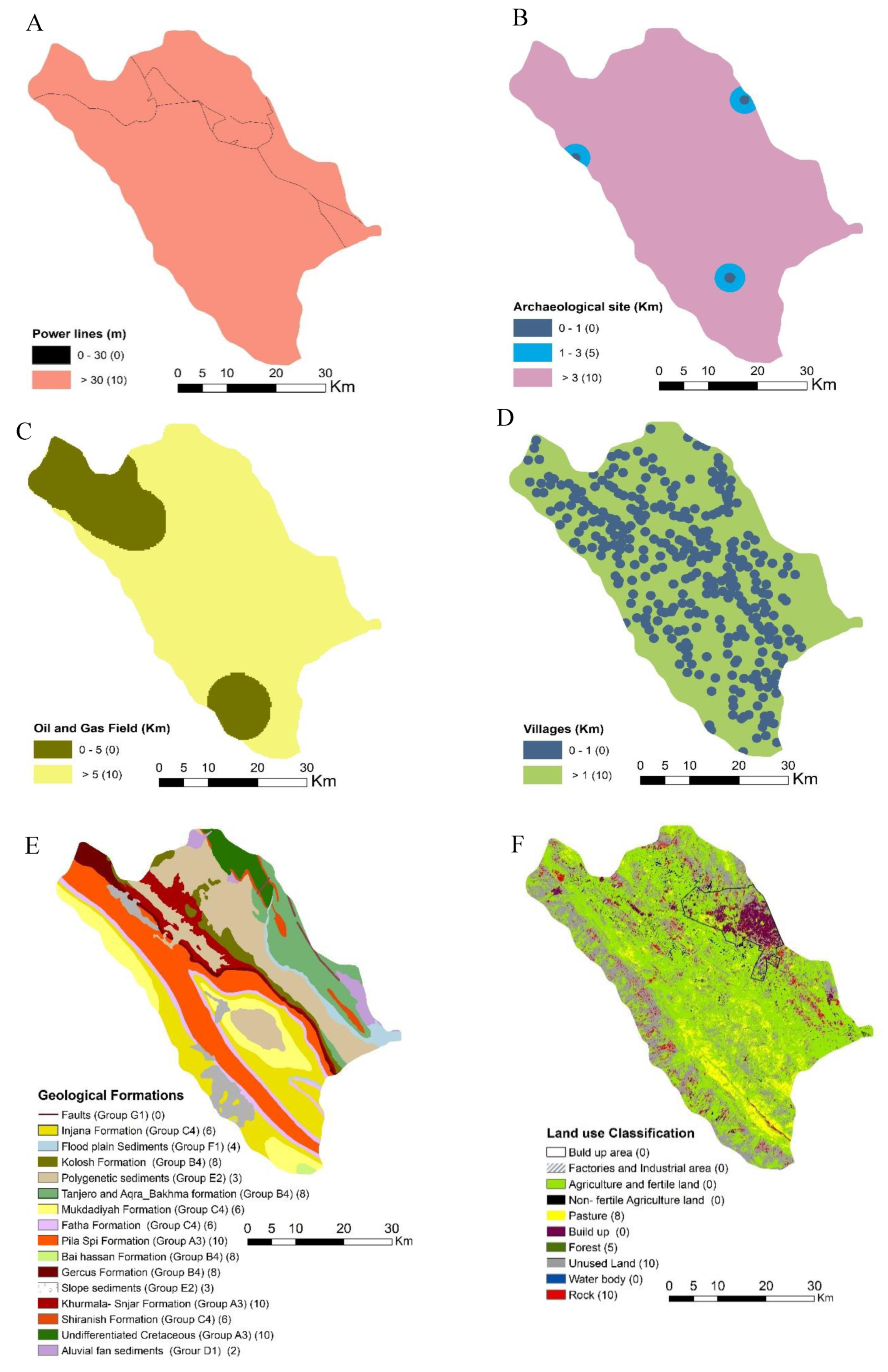
In this study, buffer zones should be more than 30 m from a landfill site to power lines on both sides, and they were given a score of 10, with distances of less than 30 m being given a grading of 0. The reason why these values are chosen to prevent the high voltage energy resulting from these lines (
Figure 4A).
The “archaeological sites” criterion was categorized into three sub-criteria, a buffer zone of less than 1 km has been classified as zero. Buffer zones of 1–3 km and those of more than 3 km were rated as 5 and 10 respectively (
Figure 4B).
Buffer zones of less than 5 km and 1 km were provided zero ratings in the “oil and gas” and “village” layers. Buffer zones higher than these values were given 10 grading values. (
Figure 4C,D).
Sub-criteria for “Geological formations” consisted of seven groups. G1, D1, E2, F1, C4, B4 and A3 were given ratings of 0, 2, 3, 4, 6, 8 and 10, respectively (
Figure 4E). The suitability index in these groups was classified according to the lithology and permeability of the sediments due to grain size distribution. The lithology of the geological formations are described as below [
42]:
- B4:
Tanjero and Aqra-Bekhma formations: Intercalation of shale, Mudstone, sandstone and conglomerate, interbedded with beds of back-reef deposit.
- B4:
Bai Hassan Formation: Sandy conglomerate and sandstone.
- B4:
Gercus Formation: Alteration of red claystone, sandstone and rare conglomerate.
- B4:
Kolosh—Sinjar Formation: Dark grey claystone, shale, siltstone and rare conglomerate.
- A3:
Undifferentiated Cretaceous.
- A3:
Pilaspi Formation: Limestone and chalky marl with chert nodules, slightly interfingering with Avana Formation.
- A3:
Khurmala Formation: Well bedded limestone.
- C4:
Mukdadiyah Formation: Pebbly sandstone, claystone and sandstone.
- C4:
Injana Formation: Sandstone interbedded with claystone.
- C4:
Fatha Formation: Cyclic deposit of claystone, marl, gypsum and sandstone with occasional limestone.
- C4:
Shiranish formation: Bluish grey marl and marly limestone.
- F1:
Flood plain Sediments: (consisting of sand, silt and mud).
- E2:
Gulneri formation (Polygenetic sediments): Dukan, Qamchuqa, Sarmord in piramagroon anticline.
- E2:
Slope sediments Pebbly, sandy, silty and clayey soil.
- D1:
Alluvial fan sediments, gravel, sand and mud.
- G1:
Faults.
The 2017 Landsat 8 (OLI) satellite image was downloaded for land use and land cover classification using remote sensing software ENVI 5.3 for image processing. Geometric correction was used through pre-processing calibration. The methods for image processing include statistical algorithms that change the visual appearance of the image, and fast line-of-sight atmospheric analysis of hypercubes (FLAASH) converted the digital images to surface reflection to remove atmospheric effects and generate a reflection of the surface image. Using the pre-processed classified images from the training data (region of interest, ROI) and considering the maximum likelihood of estimating probabilistic model parameters in a supervised classification technique based on Bayesian theory [
59], the layer of “land use” was classified into ten sub-criteria: Airport, Build up, Water body, Factories and Industrial area, Agriculture and fertile land, non-fertile and agriculture land. These were given a rate of zero due to unsuitability, while Forest, Pasture, Rock and Unused land were given a rate of 10, 8, 6 and 4, respectively (
Figure 4F).
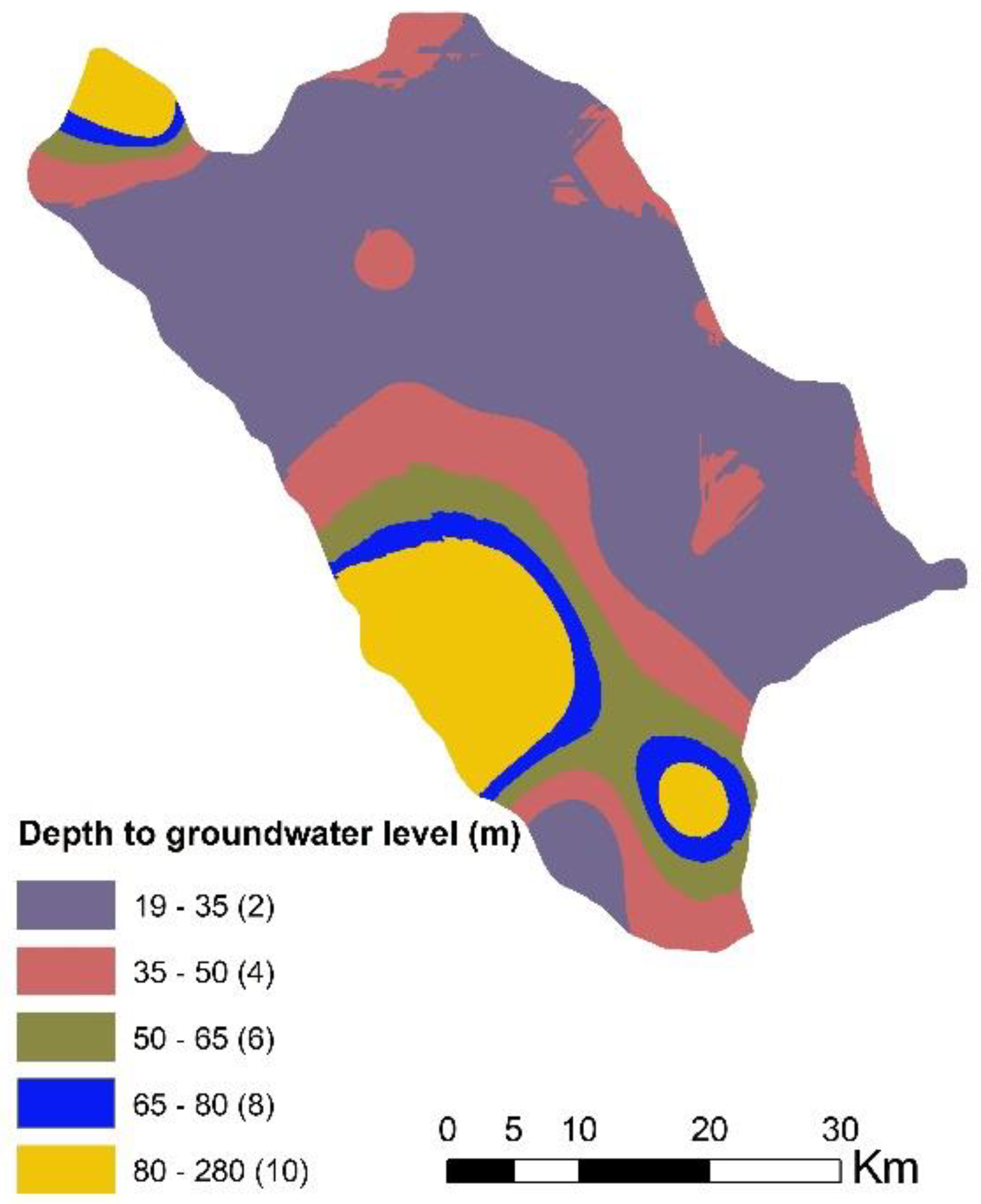
To generate the groundwater layer map, the Kriging method in geostatistical analysis tools was used in GIS to obtain the best interpolation between groundwater depths in 235 drilled wells throughout the study area. The groundwater level data measurements were carried out from 2000 to 2015 and were obtained from the (Groundwater Directorate in Sulaimaniyah). Generally, landfill site selection is influenced by groundwater depths due to the extent of groundwater contamination through leaching. In this study, groundwater depths were classified into five intervals, from 19–35 m, 35–50m, 50–65 m, 65–80 m and 80–280 m, with rating values of 2, 4, 6, 8 and 10 respectively (
Figure 5).


 ,
, 


