Article

Towards Low-Carbon Interurban Road Strategies: Identifying Hot Spots Road Corridors in Spain

Transport Research Centre, TRANSyT, Universidad Politécnica de Madrid, 28040 Madrid, Spain
*
Author to whom correspondence should be addressed.
Sustainability 2018, 10(11), 3963; https://doi.org/10.3390/su10113963
Submission received: 6 September 2018 / Revised: 26 October 2018 / Accepted: 29 October 2018 / Published: 31 October 2018
(This article belongs to the Special Issue Sustainable Road Transportation Planning)

Abstract

:
Reducing traffic emissions is key in transport planning and infrastructure management in order to achieve a sustainable transport system. This paper contributes to this topic in two ways. The first step describes a comprehensive methodology for identifying hot spots road segments and corridors with problems of GHG emissions to enable low-carbon actions. The Highway Energy Assessment (HERA) methodology is applied to the national road network of Spain in order to estimate interurban traffic emissions and calculate the emissions index to assess strategies. The results are shown graphically on a GIS, allowing to identify seven corridors with emissions problems comprising 25% of the network and being responsible for 51% of the total GHG emissions in 2012. Inefficient corridors were those with high rates of heavy vehicles, high speeds and steep gradients. The second step consists of the application of a set of strategies to reduce their emissions and their comparison to the reference scenario. The Mediterranean corridor—the most inefficient corridor—was selected to apply a set of abatement strategies. The most effective strategy was speed enforcement for light vehicles. A speed reduction of 10 km/h could produce a 3.5% savings in emissions compared to the reference scenarios, and decrease emissions intensity from 254 gCO2eq/veh-km to 246 gCO2eq/veh-km.

1. Introduction

Road transport is widely considered as an important sector for the application of abatement strategies given the marked contribution of the transport sector to energy consumption and emissions [1]. Road transport is the second largest source of emissions in the EU, accounting for 20.6% of the total greenhouse gas (GHG) emissions in 2016 [2]. Spain, with 86.131 million tons of CO2, ranked fifth out of the 28 European countries in terms of CO2 emissions in the transport sector in 2016, after Germany, France, United Kingdom and Italy [1]; road transport accounted for more than 90% of those emissions. As a result, energy efficiency measures for road transport have been implemented in Spain under the 2004–2012 and 2011–2020 Energy Saving and Efficiency Actions Plans [3,4]. The goal of the latter is to reduce the nation’s total energy consumption by 20% by 2020 in line with the Europe 2020 energy strategy [5]; one third of this target must be achieved by savings in the road transport sector [4]. However, those actions are generally adopted without addressing the most polluting points of the road network and there is a lack of appropriate feedback to gauge whether the strategies are working effectively. For instance, the 2011 Libyan oil crisis led to the establishment of the Energy Saving and Efficiency Enhancement Plan [6], with one of its measures being to reduce the speed limit on motorways from 120 km/h to 110 km/h and its effects were never subjected to a thorough analysis. On the other hand, the 2013 Environmental Assessment Law [7] considers climate change as part of the environmental impacts of a programme and requires plans to be assessed for their carbon footprint, including road transport plans.
Therefore, traffic emissions must be seen as an essential factor in transport planning and infrastructure management if sustainable transport is to be achieved. Traffic emission inventories are useful tools for identifying pollutant sources and evaluating the effectiveness of existing or potential abatement strategies, and for making decisions on where to apply the strategies [8,9,10]. Using the national road emissions inventory, Ref. [11] analysed the key drivers influencing the evolution of road GHG emissions in Spain over the last 20 years. They suggested that new actions to reduce GHG emissions from road transport in Spain should take two approaches: General actions to reduce transport use; and strategies to improve road use efficiency, including traffic management strategies and penetration of efficient vehicles. Hence, the actions towards efficient road systems pursue strategies that improve energy efficiency and lower the ratio of CO2 emissions [12]. Efficient road systems planning and management therefore refers to a set of abatement strategies that largely aim to reduce carbon footprint by operational (speed enforcement, managing heavy duty vehicles, efficient routing, and so on) and planning strategies (improving road infrastructure through new or improved road designs). In order to sort and prioritise hot spot road corridors or segments and to know the effectiveness of the abatement strategies, road transport authorities and operators require methodologies to answer the following questions: How could hot spots road corridors be easily identified for an entire road transport network at national level? How can action plans or strategies be designed to reduce traffic emissions? How efficient are these actions and strategies in reducing emissions?
This paper describes a comprehensive procedure for identifying hot spot road segments with the highest emissions, and then assesses the abatement strategies based on reference scenarios. The paper is divided into four main parts, and examines the case study of the Spanish National Road Network (NRN). First, Highway EneRgy Assessment (HERA) methodology [13] is described in Section 2, that is used for the assessment of energy consumption and GHG emissions for different highways and traffic flow scenarios and the representation of outcomes in a geo-referenced database allowing the results to be graphically represented for the case study of Spain. Secondly, it describes the procedure for identifying hot spots in the road network based on the geographical representation and emissions intensity (Section 3). Third, once hot spot corridors have been identified, managers can decide the most appropriate strategies for each particular case (the corrective actions that can be taken in each corridor) to reduce emissions on road stretches. Section 4 describes an illustrative case study based on the most emissions-intensive corridor identified in Section 3. Finally, Section 5 contains its contribution to the research, and conclusions.

2. Methodology and Data

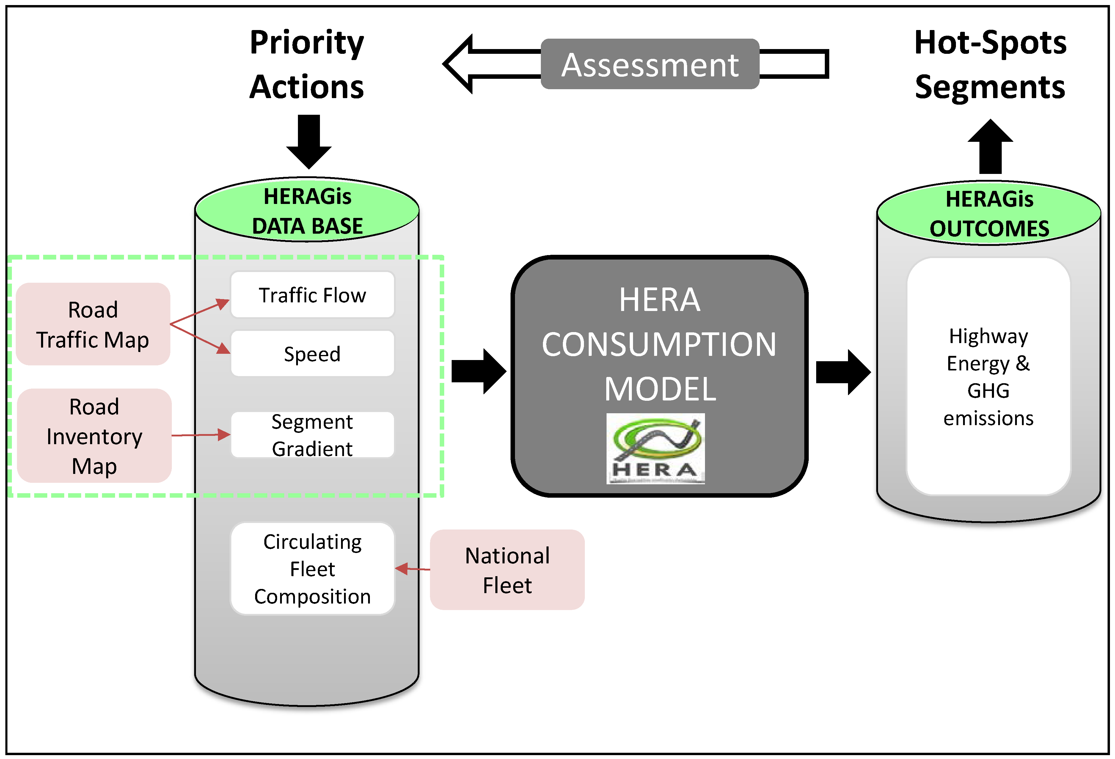
2.1. HERA Methodology: Highway Emissions Assessment

The HERA methodology is used to assess the energy and carbon footprint of highways’ traffic flow [13]. The main features of HERA methodology are shown in Figure 1. HERA is based on a bottom-up methodology which combines an average speed consumption model adjusted with a segment gradient and information on the spatial distribution, by road segment, of vehicle activity with data on vehicle type (average annual daily traffic—AADT-), driving speeds (mean speed of light and heavy vehicles), physical characteristics of the road (length, gradient, number of lanes), and the composition of the fleet circulating along these roadway types. Since HERA is designed for interurban traffic, the transient process of traffic emission such as acceleration or deceleration is not captured, being more important for urban areas assessment [14,15]. HERA produces several outputs: annual GHG emissions and energy consumption (CO2eq/year and MJ/year, respectively), and emissions and energy intensity (CO2eq/veh-km and MJ/veh-km, respectively). Emissions intensity is the emission rate of CO2eq produced by an average vehicle and per km of a given road section. Emission intensity is strongly correlated with traffic flow characteristics, operation strategies and driving behaviour. The main capability of HERA is that it enables strategies to be devised for carbon efficient management of the highway operation and gradient design. These strategies could be applied to a segment of a highway or to an entire network. Policies can be planned to achieve efficient targets by acting on the main input variables (such as speed, road gradient or vehicle type) [16]. One of HERA’s capabilities is that input data—traffic maps and road inventory which are usually geo-referenced—could be merged in the HERAGis input database in order to obtain geo-referenced results.

2.2. Case Study: Spanish National Road Network (NRN)

The Spanish National Road Network (which belongs to the Spanish Government) with data of the year 2012 is used as a case study. In 2012, NRN consisted of 26,038 km, accounting for 15.7% of the total length of the Spanish network (national and regional governments and lesser extent cities) [17]. The Spanish NRN comprises toll and free motorways, two-lane main roads and metropolitan motorways. It carries 51.6% of total traffic and 63.1% of heavy traffic flows. Consequently, the current case study—NRN—offers an accurate depiction of the characteristics of interurban traffic in Spain.
Data input for HERA is the result of linking two geo-referenced databases. On the one hand, the Spanish Road Traffic Map [17] is based on road traffic counts and provides annual information on the traffic flow characteristics of the NRN. The 26,038 km of the NRN were divided into 4778 homogeneous segments in traffic terms (average segment of 5.44 km). Each segment is geo-referenced as vector data in GIS. On the other hand, the Spanish Road Inventory which compiles geo-reference data on the geometric features and facilities of each segment of the road network (geometry, road type, number of lanes, gradient, visibility distance, coordinates, road equipment, and vertical and horizontal signals, among others) [18]. The two databases were integrated into one HERAGis database. HERA model calibrated for the Spanish circulating fleet composition [19] for the year of 2012 is applied to the HERAGis Datase and on-road GHG emissions (CO2eq emissions) are estimated at the segment scale for 2012. Table 1 below shows a summary of the results by road type.
In 2012, the Spanish NRN emitted around 28 million tons of CO2eq, with more than half corresponding to free motorways. This total amount represents 37.65% of the total emissions from the entire Spanish road transport (including regional and local road networks). Motorways were the most important contributor to this figure, which is in line with the high proportion of heavy vehicles (17% of total traffic volume) and the speed for light vehicles (110 km/h on average). The emissions intensity outcomes serve to identify the efficiency of each segment with the driving conditions prevailing in 2012. The lower the intensity, the more efficient the segment. The CO2eq emissions per vehicle and kilometre in an average segment is 247 grams for average traffic of 14% heavy-duty vehicles and a speed of 93 km/h for light vehicles. As before, free motorways had the highest emission intensity, with 275 grams of CO2eq emissions per vehicle and kilometre on average.
Lastly, Figure 2 shows the map with the total GHG emissions of the HERAGis network. Each link has a different colour, denoting the categories of emissions. The results highlight the strong influence of certain corridors or segments of the emissions of the entire NRN (in red and orange). Its analysis reveals that heavy vehicle share—segments carrying high rates of heavy vehicles—are more polluting regardless of road type, road gradient and high and low speeds of light vehicles.

3. Identification of Hot Spot Corridors

3.1. Procedure for Emissions Priority Index

The identification of hot spots corridors is based on the calculation of an index which takes into account segments with high emissions and/or high emission intensity—Emissions Priority Index EPI. Similar to Reference [20], for noise impacts, the EPI aims to identify hot spots, and the nature of the relationship between traffic flow, speed and gradient, in order to act on them and reduce GHG emissions. The variables involved in estimating EPI are:
  • Total emissions per segment (measured as CO2eq) express the annual emissions produced by the actual traffic flow
  • Emissions intensity per segment (measured as CO2eq/veh-km) serves to identify the most polluting segments based on their traffic operation and infrastructure design.
The EPI is estimated by taking into account the traffic flow characteristics and operating conditions in the segment when identifying hot spots. The first step is the normalization from 0 to 1 of these two variables in order to obtain two indicators: Total Emissions (TE) and Emissions Intensity (EI). To that end, it uses the ArcGis standard deviation classification method which shows how much total emissions or emission intensity values varies from the mean. This method creates class breaks with ranges of equal values that are a proportion of the standard deviation (at intervals of ¼ of the standard deviation using the mean values and standard deviations of the average). The Emission Priority Index EPI for each segment is obtained by combining the two indicators TE and EI. The index is:
  • No priority when TE and EI <0.5
  • High priority when TE or EI ≥0.5
  • Very high priority when TE and EI ≥0.5
On the basis of the EPI values for each segment, a hot spot corridor is identified when at least half its length has a high and very high priority EPI index.

3.2. Identification of Hot Spot Corridors in the Spanish NRN

After the calculation of EPI, Figure 3 below shows the identification of seven hot spot corridors with half their length highlighted in orange and red (high and very high priority, respectively). These corridors connect major cities such as Barcelona, Seville and Bilbao to the capital, Madrid. Nevertheless, the Mediterranean corridor (east) also appears as a priority corridor, given the importance of this transport axis connecting France to southern Spain along the coast.
Table 2 also contains a summary of the outcomes for each corridor. Four road characteristics were used to group the identified corridors: Whether the route has in some sections two alternatives (toll vs. free), is a main corridor (high volume of traffic), has a high proportion of heavy vehicles, and is a mountain route (hilly areas). All the selected corridors correspond to one or more of these categories (lower part of the Table 2).
The seven priority corridors were responsible for 51% of the total emissions of the NRN, although they only account for 25% of the network length. The route with the highest emissions is the Mediterranean corridor (7), which contributed to 16.85% of the total NRN emissions. This is the longest corridor and has the highest volume of traffic. The least efficient corridor was the northeast corridor (2), which had an average emission intensity of 315 gCO2eq/veh-km over its 1054 km. This was caused by the high volume of traffic (24,394 vehicles per day) and the high rate of heavy vehicles (23.4%). Among hilly areas, the northwest corridor (6) has the most steeply sloping road; 11% of its length has a gradient over 2% in absolute figures. This corridor accounted for 4.64% of the total NRN carbon footprint. Finally, the typologies of all the selected corridors included alternative itineraries along parts of their routes. For instance, all corridors that start or end in Madrid have two alternatives: either a toll road in the first part, or a free motorway. In these cases, the main strategy to achieve emissions reduction is a more effective use of road toll capacity [16]. For example, Ref. [16] revealed that transferred heavy-duty vehicle flows to high-quality toll motorways could reduce energy consumption by 0.65%. In the following Section 4, the Mediterranean corridor is taken as an example for illustrating the application of efficient abatement strategies, since it fulfils the four hot spot corridors characteristics.

4. Mediterranean Corridor: A Case Study for Low-Carbon Road Network Strategies

The Mediterranean corridor (7) is selected to apply a set of abatement strategies. These strategies generally aim to reduce GHG emissions by improving road system capacity and efficiency. Based on HERA methodology (Figure 1), the proposed strategies seek to promote efficiency through operational and infrastructure improvements, as they were presented in Reference [13].
  • Operational strategies focus on minimising emissions through speed enforcement and heavy-duty traffic management to promote efficient use of the network (efficient routing and more effective use of road capacity). The aim is to promote optimal fuel use efficiency.
  • Infrastructure strategies seek to reduce emissions by improving the road infrastructure through new or improved constructions, for example by correcting the alignment of the road and reducing steep sections in the design phase.
Four scenarios were created to estimate the effects of the strategies on GHG emissions. These four hypothetical scenarios were compared to a reference scenario based on the characteristics of the corridor in 2012. The reference scenario for the Mediterranean corridor is characterised by an AADT of 27,865 veh/day and an average share of heavy vehicles of 15.81%. The corridor comprises toll motorway, free motorway, two-lane main roads and metropolitan motorways, with a total length of 1788 kilometres. Only 0.24% of the corridor length has a gradient of over 4%. The four policy scenarios are the following:
  • Scenario I: Light vehicle management scenario is tested by calculating the impact of reducing the speed of light vehicles on toll, free and metropolitan motorways by −10 km/h from the reference scenario on the whole corridor.
  • Scenario II: Heavy vehicle management scenario assumes that all stretches with over 15% of heavy vehicles reduce their speed by −10 km/h on toll, free and metropolitan motorways.
  • Scenario III: Alignment improvement scenario considers the same network as the reference (same vehicle distribution and average speed) but with 0% slope in the segments.
  • Scenario IV: Integration of all strategies assumes that all three scenarios above are integrated into one.
Table 3 shows the annual emissions results for each proposed scenario by road type in the Mediterranean corridor. The results also indicate the percentage of emissions savings over the total corridor. All the scenarios produce a reduction in emissions. Of the first three scenarios, the speed management scenario for light vehicles is the most GHG-effective option, and results in annual emissions savings of 3.54% over the total corridor. The highest savings occur on toll roads, since these have the highest average speeds. A 10 km/h decrease in light vehicle speed results in a 10 gCO2eq/veh-km reduction in the motorway stretches considered. The findings also show that proper network design—consisting of modifying hilly areas—is a key element when improving the carbon efficiency of road traffic. Emissions savings of 1.28% are obtained by acting on only 0.24% of the network corridor. Finally, the integration of all scenarios produces savings of up to 279.668 KtCO2eq/year, corresponding to 5.75% of the total emissions for the corridor.

5. Discussion and Conclusions

Reducing traffic emissions is a priority in transport planning and infrastructure management in order to achieve a more sustainable transport system [1]. The emissions assessment methodologies include the HERA methodology [13] which combines an average speed consumption model adjusted with segment gradient and information on spatial distribution by road segment. Based on the HERA methodology and the Spanish NRN case study, this paper contributes new procedures and policies for debate.
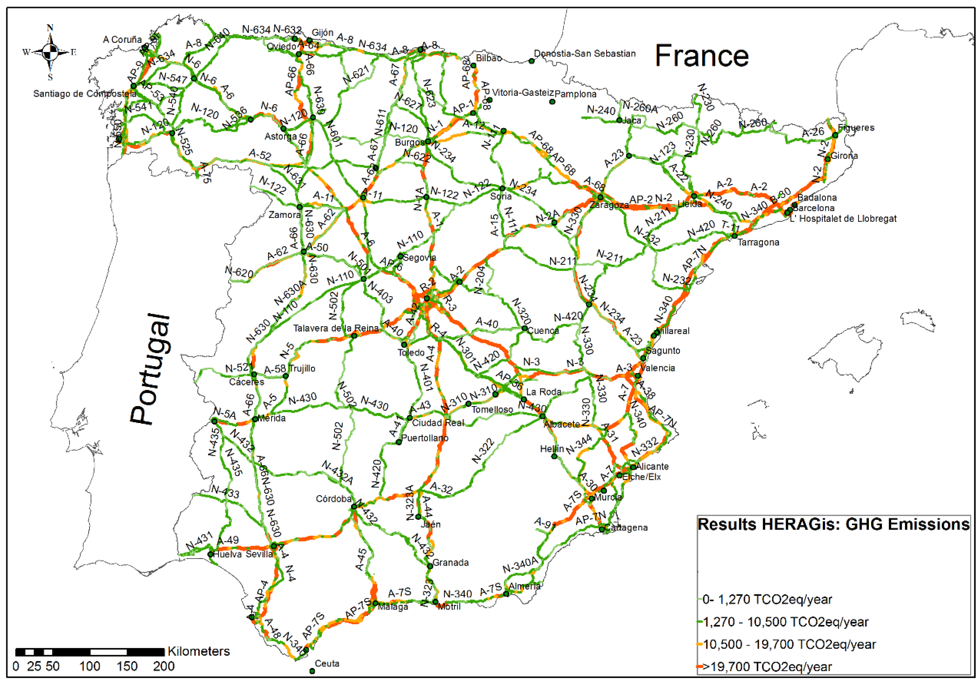
  • The advantages of geo-referenced databases and results. The study uses a GIS to create a platform to combine traffic and infrastructure databases in the HERA input database. While many research efforts have taken advantage of the spatial environment of a GIS to integrate traffic models and emissions models and perform various aspects of transportation-related emissions modelling [21,22,23,24], these have tended to combine emissions inventory methods and GIS to produce maps and files with geo-referenced emissions in a grid format using proxies (i.e., road density, population, and so on). The use of segment traffic flow data to allocate on-road emissions and their representation (vector) reduces the uncertainty associated with downscaling regional or state-level data to such high resolutions [25,26]. The current paper proposes a method to merge geo-referenced databases (traffic and infrastructure data) and obtain emissions maps using an emission model. The total GHG emissions of the NRN for 2012 are shown by a segment in Figure 2. This segment-by-segment representation makes it easier to identify hot spot corridors. An application of GIS to show emissions in a vector format is a worthy contribution improving the decision making process regarding road network management.
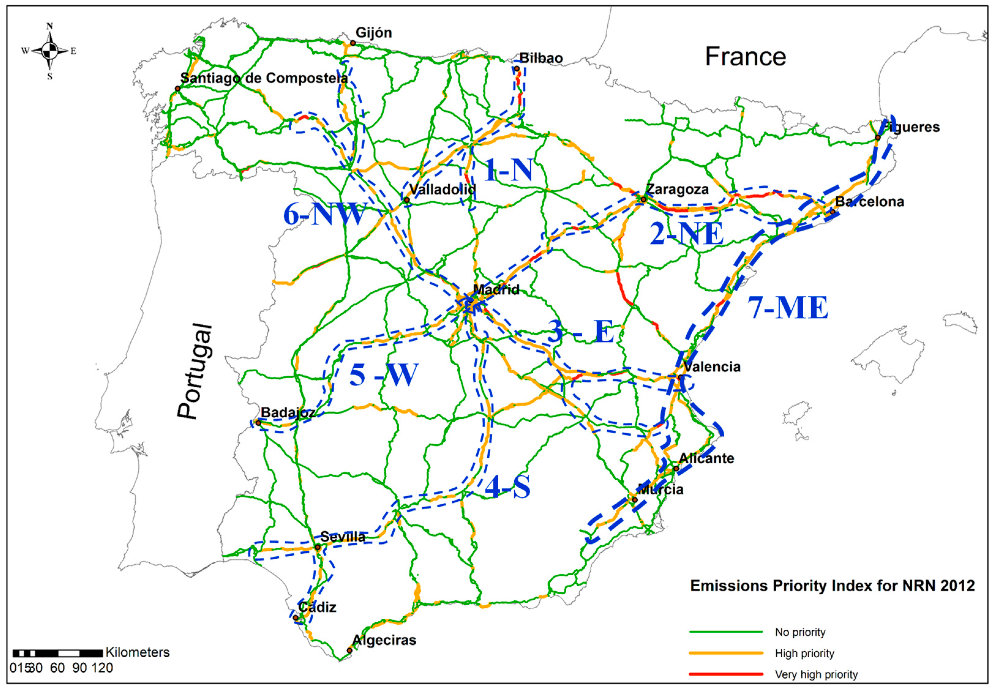
  • Identification of hot spot corridors. To tackle climate change problems, it is especially important to establish a priority-ordered plan [27]. Strategies can therefore be applied to the most polluting areas in order to obtain the highest savings. The paper proposed an index (EPI in Section 3) which sorts by priority all road segments or corridors with emissions problems. The EPI was obtained for the Spanish NRN and is shown in Figure 3. Seven corridors were recognised as hot spots. These top seven corridors comprise 25% of the network and are responsible for 51% of the total GHG emissions of the NRN. The outcomes show that these inefficient corridors have a high rate of heavy vehicles, high speeds and steep gradients.
  • Designing operational and infrastructure strategies using HERA. Reducing road network emissions requires designing and implementing ad-hoc strategies. Emissions assessment methodologies so far have focused on the separate parts of the road systems: exclusively on road traffic operation [28]; or on the design, construction and maintenance phases; or on infrastructure [29]. However, attention must be paid to the combined effect of the infrastructure and road traffic. For instance, the effect of road alignment on vehicle emissions [30] or the effect of maintenance works on traffic flow performance [31]. Specifically, HERA is of particular interest for policies and strategies focused on alignment design, speed adjustment, traffic flow management, and fleet composition. It can be used both in the early planning and design stages and when the road is in operation. The study assesses different strategies in the most polluting Mediterranean corridor. The outcomes show that the integration of speed adjustment (both in light and heavy-duty vehicles) and alignment improvements would result in savings of 5.42% compared to the reference scenario. The most effective strategy is speed enforcement for light vehicles, which could decrease emissions intensity by an average of 10 gCO2eq/veh-km, with a speed reduction of 10 km/h. Another important measure would be to improve road alignment in hilly areas.
In conclusion, the paper highlights the usefulness of HERA methodology application at the national level for estimation of interurban traffic GHG emissions and how the identification of hot spot corridors could benefit the application of a set of strategies to reduce emissions from the road network. The geo-reference of road emissions and EPI index allows hot spots to be easily identified so that priority actions can be designed for these areas. Further research will involve an exploratory analysis of the most influential factors on the carbon footprint of interurban road traffic. Another particularly relevant aspect is the introduction of this method into a decision support system for measuring the territorial impact of road transport infrastructure [32], in order to consider all impacts in the environmental assessment of the road planning and including the cost-effectiveness of the proposed abatement measures.

Author Contributions

N.S. was responsible for the research study. A.M. coordinated the research, reviewed the manuscript and proposed changes and improvements to its structure.

Funding

This research received no external funding.

Acknowledgments

The authors would like to thank Pablo Pérez de Villar for providing data from the Spanish road inventory and Luis Gonzaga García for his helpful comments on the use of GIS tools. N.S. wishes to thank the Universidad Politecnica de Madrid (UPM) for the research fellowship that allowed her to develop this research work.

Conflicts of Interest

The authors declare no conflict of interest.

References and Note

  1. Sims, R.; Schaeffer, R.; Creutzig, F.; Cruz-Nuñez, X.; D’Agosto, M.; Dimitriu, D.; Figueroa, M.J.; Fulton, L.; Kobayashi, S.; Lah, O.; et al. Transport. In Climate Change 2014: Mitigation of Climate Change. Contribution of Working Group III to the Fifth Assessment Report of the Intergovernmental Panel on Climate Change; Cambridge University Press: Cambridge, UK; New York, NY, USA, 2014. [Google Scholar]
  2. EEA. EEA Greenhouse Gas—Data Viewer. [Database]. 2018. Available online: http://www.eea.europa.eu/data-and-maps/data/data-viewers/greenhouse-gases-viewer (accessed on 6 August 2018).
  3. IDAE. Spanish Strategy of Energy Saving and Efficiency 2004–2012 E4. Madrid, 2003. Available online: http://www.idae.es/uploads/documentos/documentos_XXXX_EstrategiaAyEE_E4_2003_6e709456.pdf (accessed on 6 August 2018).
  4. IDAE. Second Action Plan of Spanish Strategy of Energy Saving and Efficiency 2011–2020. Madrid, 2011. Available online: http://www.idae.es/uploads/documentos/documentos_11905_PAEE_2011_2020._A2011_A_a1e6383b.pdf (accessed on 6 August 2018).
  5. EC. Communication from the Commission to the Council, the European Parliament, the European Economic and Social Committee and the Committee of the Regions. Energy 2020 a Strategy for Competitive, Sustainable and Secure Energy. COM (2010) 639 Final. 2010. Available online: http://eur-lex.europa.eu/LexUriServ/LexUriServ.do?uri=COM:2010:0639:FIN:EN:PDF (accessed on 6 August 2018).
  6. MINETUR. Plan for Enhancement of Energy Saving and Efficiency. 2011. Available online: http://istas.net/descargas/presentacionplanintesiahorro040311.pdf (accessed on 17 May 2018).
  7. Spanish Government. Environmental Assessment Law. 2013. Available online: https://www.boe.es/buscar/act.php?id=BOE-A-2013-12913 (accessed on 6 August 2018).
  8. Bellasio, R.; Bianconi, R.; Corda, G.; Cucca, P. Emission inventory for the road transport in Sardinia (Italy). Atmos. Environ. 2007, 41, 677–691. [Google Scholar] [CrossRef]
  9. Fulton, L.; Lah, O.; Cuenot, F. Transport Pathways for Light Duty Vehicles: Towards a 2 degrees Scenario. Sustainability 2013, 5, 1863–1874. [Google Scholar] [CrossRef]
  10. Vanhulsel, M.; Degraeuwe, B.; Beckx, C.; Vankerkom, J.; De Vlieger, I. Road transportation emission inventories and projections—Case study of Belgium: Methodology and pitfalls. Transp. Res. Part D Transp. Environ. 2014, 27, 41–45. [Google Scholar] [CrossRef]
  11. Sobrino, N.; Monzon, A. The impact of economic crisis and policy actions on GHG emissions from road transport in Spain. Energy Policy 2014, 74, 486–498. [Google Scholar] [CrossRef]
  12. Banister, D.; Anderton, K.; Bonilla, D.; Givoni, M.; Schawanen, T. Transportation and the Environment. Annu. Rev. Environ. Resour. 2011, 36, 247–270. [Google Scholar] [CrossRef]
  13. Sobrino, N.; Monzon, A.; Hernández, S. Reduced Carbon and Energy Footprint in Highway Operations: The Highway Energy Assessment (HERA) Methodology. Netw. Spat. Econ. 2016, 16, 395–414. [Google Scholar] [CrossRef]
  14. Coloma, J.F.; García, M.; Wang, Y.; Monzón, A. Green Eco-Driving Effects in Non-Congested Cities. Sustainability 2018, 10, 28. [Google Scholar] [CrossRef]
  15. Garcia-Castro, A.; Monzon, A.; Valdes, C.; Romana, M. Modelling different penetration rates of eco-driving in urban areas: Impacts on traffic flow and emissions. Int. J. Sustain. Transp. 2017, 11, 282–294. [Google Scholar] [CrossRef]
  16. Monzon, A.; Sobrino, N.; Hernandez, S. Energy- and Environmentally Efficient Road Management: The Case of the Spanish Motorway Network. Procedia Soc. Behav. Sci. 2012, 48, 287–296. [Google Scholar] [CrossRef] [Green Version]
  17. Ministerio Fomento. Spanish Traffic Map 2012. 2013. Available online: https://www.fomento.es/carreteras/trafico-velocidades-y-accidentes-mapa-estimacion-y-evolucion/mapas-de-trafico (accessed on 6 August 2018).
  18. Ministerio Fomento. Spanish Road Network Inventory. 2010. Available online: http://www.fomento.gob.es/MFOM/LANG_CASTELLANO/DIRECCIONES_GENERALES/CARRETERAS/NORMATIVA_TECNICA/INVCARRETERAS (accessed on 6 August 2018).
  19. Sobrino, N.; Hernandez, S.; Monzon, A. Composición del parte de Vehículos Circulante Español a Fecha 31–12–2012 (Spanish Circulating Fleet Composition). Database Registration M-003997/2013. 2013.
  20. Ruiz-Padillo, A.; Torija, A.J.; Ramos-Riado, A.; Ruiz, D.P. A methodology for classification by priority for action: Selecting road stretches for network noise action plans. Transp. Res. Part D Transp. Environ. 2014, 29, 66–78. [Google Scholar] [CrossRef]
  21. Gualtieri, G.; Tartaglia, M. Predicting urban traffic air pollution: A GIS framework. Transp. Res. Part D Transp. Environ. 1998, 3, 329–336. [Google Scholar] [CrossRef]
  22. Bachman, W.; Sarasua, W.; Hallmark, S.; Guensler, R. Modeling regional mobile source emissions in a geographic information system framework. Transp. Res. Part C Emerg. Technol. 2000, 8, 205–229. [Google Scholar] [CrossRef]
  23. Mensink, C.; De Vlieger, I.; Nys, J. An urban transport emission model for the Antwerp area. Atmos. Environ. 2000, 34, 4595–4602. [Google Scholar] [CrossRef]
  24. Chang, C.T.; Lin, T.P. Estimation of Carbon Dioxide Emissions Generated by Building and Traffic in Taichung City. Sustainability 2018, 10, 112. [Google Scholar] [CrossRef]
  25. Gurney, K.R.; Razlivanov, I.; Song, Y.; Zhou, Y.; Benes, B.; Abdul-Massih, M. Quantification of Fossil Fuel CO2 Emissions on the Building/Street Scale for a Large U.S. City. Environ. Sci. Technol. 2012, 46, 12194–12202. [Google Scholar] [CrossRef] [PubMed]
  26. Kinnee, E.J.; Touma, J.S.; Mason, R.; Thurman, J.; Beidler, A.; Bailey, C.; Cook, R. Allocation of onroad mobile emissions to road segments for air toxics modeling in an urban area. Transp. Res. Part D Transp. Environ. 2004, 9, 139–150. [Google Scholar] [CrossRef]
  27. Unal, A.; Frey, H.C.; Rouphail, N.M. Quantification of highway vehicle emissions hot spots based upon on-board measurements. J. Air Waste Manag. Assoc. 2004, 54, 130–140. [Google Scholar] [CrossRef] [PubMed]
  28. Grant, M.; Hartley, W.S.; Milam, R.; Walters, J.; O’Rourke, L.; Brickett, L.; Suter, S. Handbook for Estimating Transportation Greenhouse Gases for Integration into the Planning Process. U.S. Department of Transportation Federal Highway Administration. Available online: https://www.fhwa.dot.gov/environment/sustainability/energy/publications/ghg_handbook/index.cfm (accessed on 7 August 2018).
  29. TAGG. Greenhouse Gas Assessment Workbook for Road Projects. 2013; Transport Roads and Maritime Services. Available online: http://www.rms.nsw.gov.au/documents/about/environment/greenhouse-gas-assessment-workbook-road-projects.pdf (accessed on 7 August 2018).
  30. Park, S.; Rakha, H. Energy and Environmental Impacts of Roadway Grades. Transp. Res. Rec. J. Transp. Res. Board 2006, 1987, 148–160. [Google Scholar] [CrossRef]
  31. Huang, Y.; Bird, R.; Bell, M. A comparative study of the emissions by road maintenance works and the disrupted traffic using life cycle assessment and micro-simulation. Transp. Res. Part D Transp. Environ. 2009, 14, 197–204. [Google Scholar] [CrossRef]
  32. Ortega, E.; Otero, I.; Mancebo, S. TITIM GIS-tool: A GIS-based decision support system for measuring territorial impact of transport infrastructures. Expert Syst. Appl. 2014, 41, 7641–7652. [Google Scholar] [CrossRef]
Figure 1. HERA methodology (based on Reference [13]).
Sustainability 10 03963 g001
Figure 2. GHG emissions of the Spanish NRN—HERAGis network—by segment.
Sustainability 10 03963 g002
Figure 3. Identification of hot spot corridors based on EPI in Spanish NRN, 2012.
Sustainability 10 03963 g003
Table 1. Summary of the main characteristics and emissions of the Spanish NRN in 2012.
Road TypeToll MotorwayFree MotorwayTwo-Lane Main RoadMetropolitan MotorwayTotal
Length (km)2548785814,73388126,020
AADT (veh/day)15,85821,489448042,52312,019
Average share of heavy vehicles (%)12.04%17.01%13.19%8.69%14.08%
Average speed light vehicles (km/h)106110829593
Average emissions intensity (gCO2eq/veh-km)258.5275.2231.6221.7247.0
Total emissions (Kt CO2eq)3882.715,804.15554.82892.728,134.3
% total emissions13.81%56.17%19.74%10.28%
Table 2. Hot spots corridor results.
1. North Corridor
N
2. Northeast Corridor
NE
3. East Corridor
E
4. South Corridor
S
5. West Corridor
W
6. Northwest Corridor
NW
7. Mediterranean Corridor
ME
Total Hot Spot Corridors
Total length (km)487105473699953593817886537
AADT (veh/h)14,93124,39421,43125,18219,84715,11327,865
Average share of heavy vehicles (%)23.76%23.42%20.95%16.04%12.73%14.55%15.81%
Average speed of light vehicles (km/h)9798108106109101100
%km gradient > 2%2.00%8.59%0.00%1.00%0.00%11.46%1.32%
%km gradient > 4%0.00%0.00%0.00%0.00%0.00%8.36%0.22%
Total Kt CO2eq8132701153322619271308471914,283
% total emissions NRN2.89%9.60%5.45%8.04%3.30%4.64%16.77%50.69%
Average emission intensity (gCO2e/veh-km)306315287261259260257275
CORRIDOR CHARACTERISTICS
Two alternative routes: toll vs. free motorway or two-lane main road
Main corridor (AADT > 20,000 veh/day)
High proportion of heavy vehicles (%HV > 15%)
Mountain route (Segments with gradient > 4%)
Table 3. GHG emissions results of road system management strategies in the Mediterranean corridor (2012).
Scenario DescriptionGHG Emissions Results (KtCO2eq/year)GHG Emissions Savings (%)Average Emissions Intensity (gCO2eq/veh-km)
Reference Scenario4887.348-253.817
Toll motorway1783.391-278.475
Free motorway1698.541-252.335
Two-lane main road956.923-236.256
Metropolitan motorway448.492-220.974
Scenario I: Light vehicle management scenario4714.2373.54%246.212
Toll motorway1699.4924.70%264.798
Free motorway1627.4534.19%241.762
Two-lane main road956.9230.00%236.256
Metropolitan motorway430.3694.04%211.941
Scenario II: Heavy vehicle management scenario4838.8000.99%251.863
Toll motorway1758.8691.38%274.818
Free motorway1677.0671.26%249.272
Two-lane main road956.9230.00%236.256
Metropolitan motorway445.2250.73%219.888
Scenario III: Alignment improvement scenario4825.7771.28%250.180
Toll motorway1781.7210.09%277.066
Free motorway1677.7421.22%246.942
Two-lane main road942.5661.50%232.560
Metropolitan motorway423.7465.52%209.610
Scenario IV: Integration of all strategies4607.6805.72%240.466
Toll motorway1673.4756.16%259.876
Free motorway1578.1176.56%233.823
Two-lane main road942.5671.50%232.600
Metropolitan motorway404.5199.80%200.394

