Analyzing the Level of Accessibility of Public Urban Green Spaces to Different Socially Vulnerable Groups of People

Abstract
1. Introduction
- How does the socially vulnerable group population size affect the demand for urban green public parks?
- What is the effect of community area size on the accessibility of green public parks?
- Does community area population density influence accessibility?
2. Methods and Materials
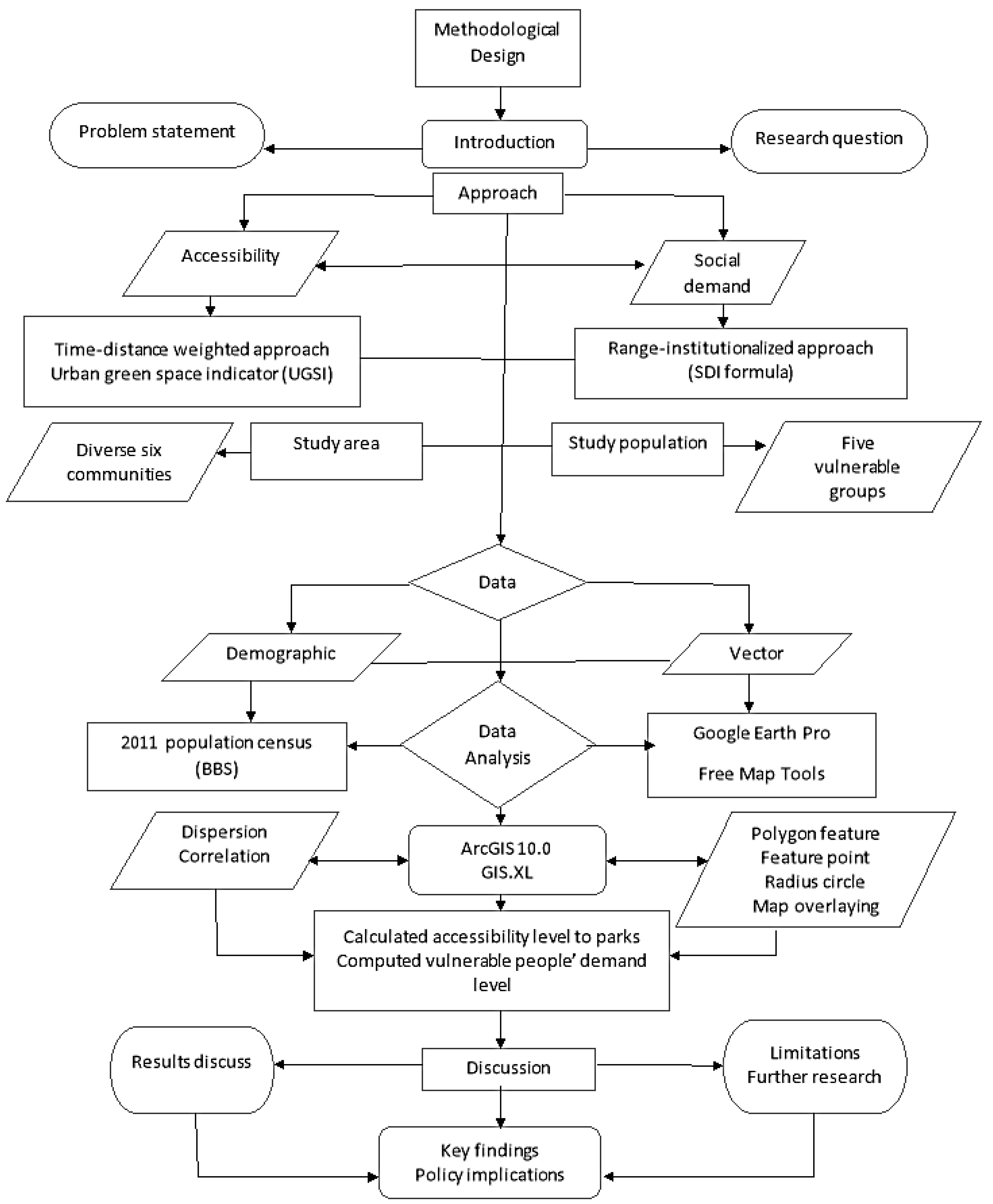
2.1. Methodological Design Flow
2.2. Methodological Approach
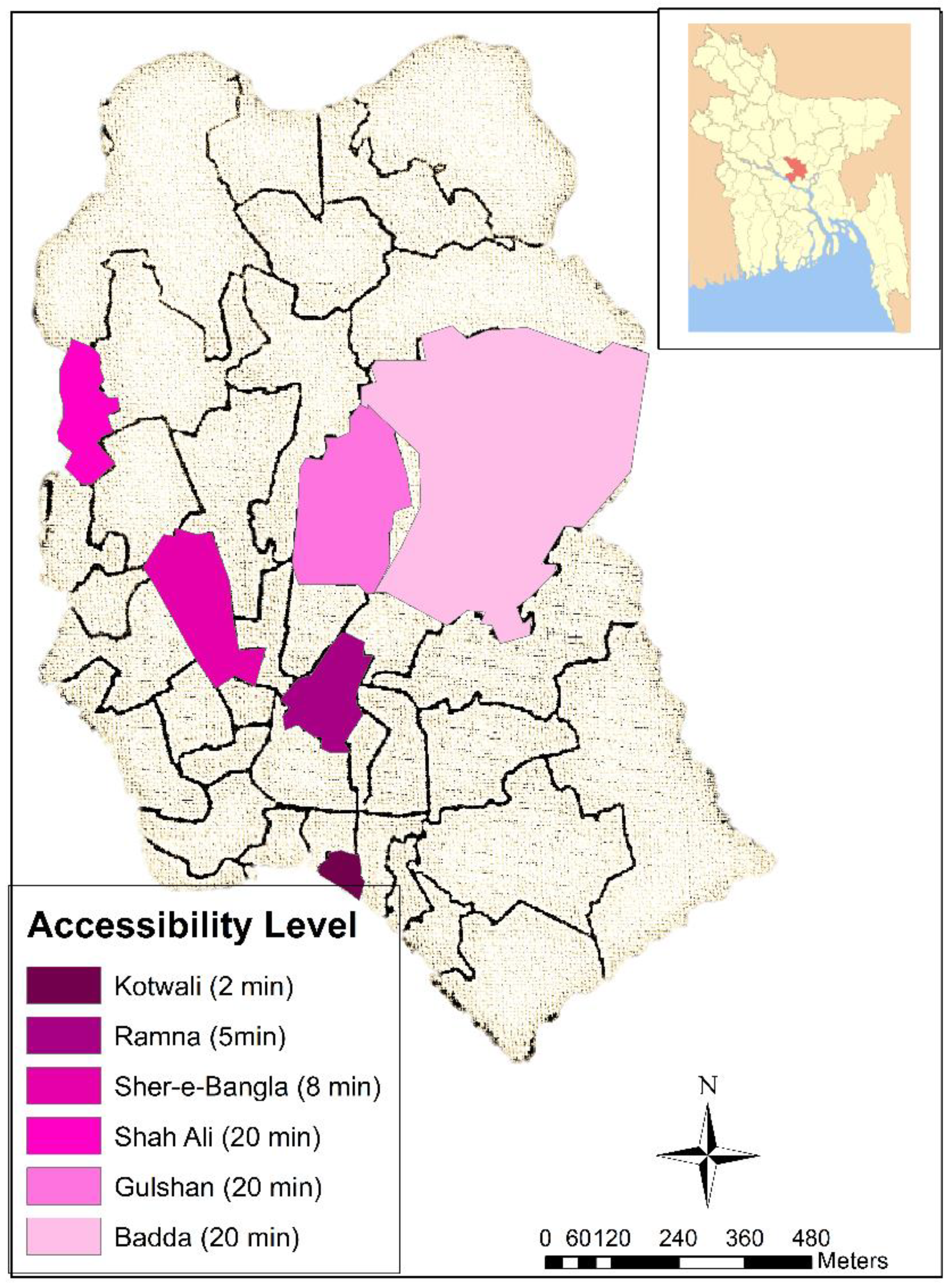
2.3. Accessibility Level Measurement 1
2.4. Accessibility Level Measurement 2
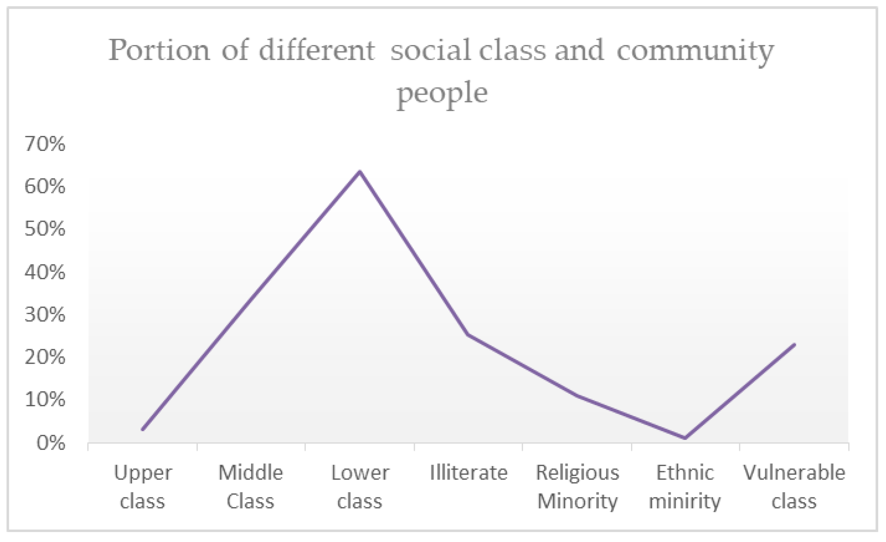
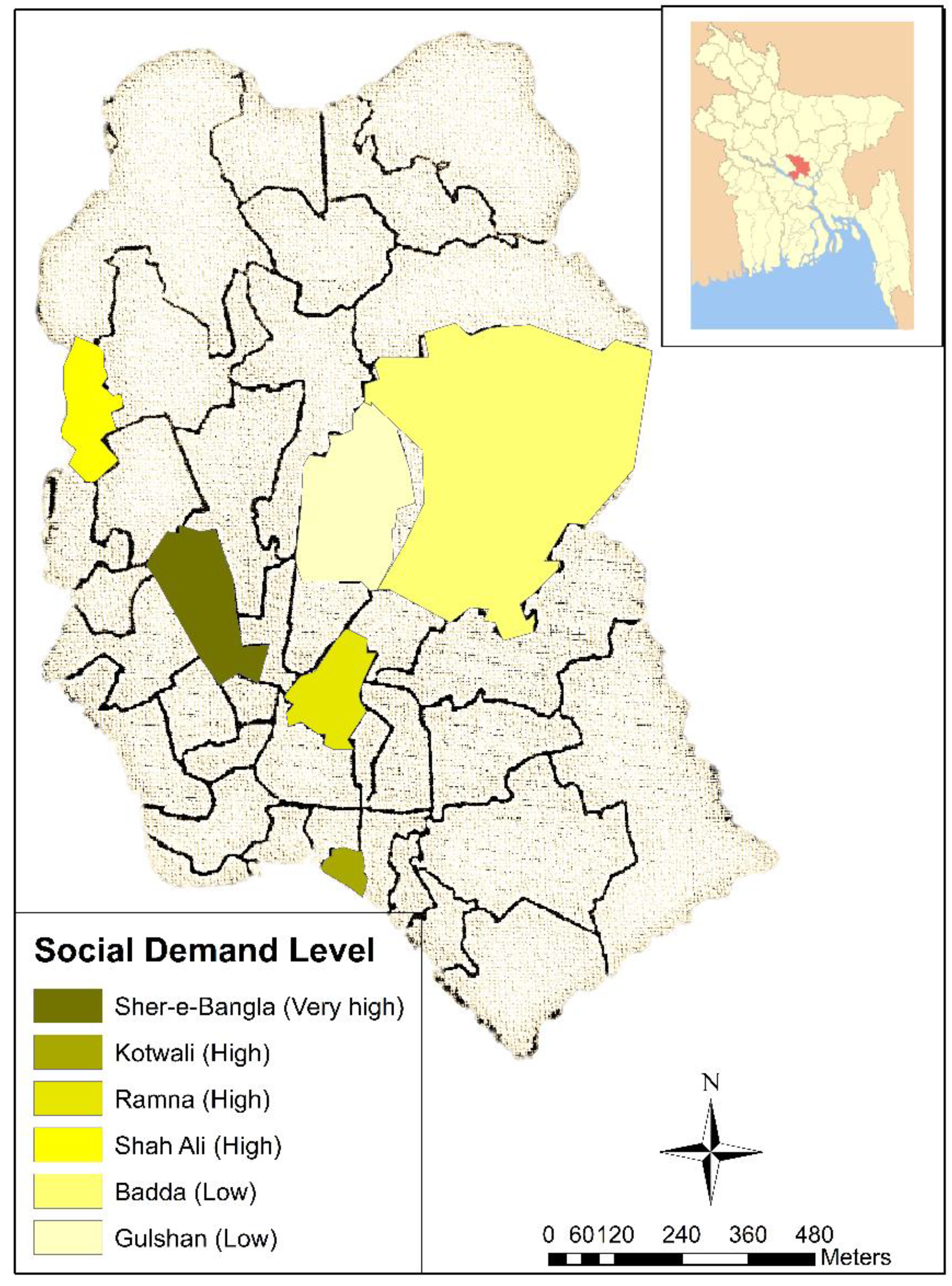
2.5. Socially Vulnerable Groups Demand Index (SDI) Assessment
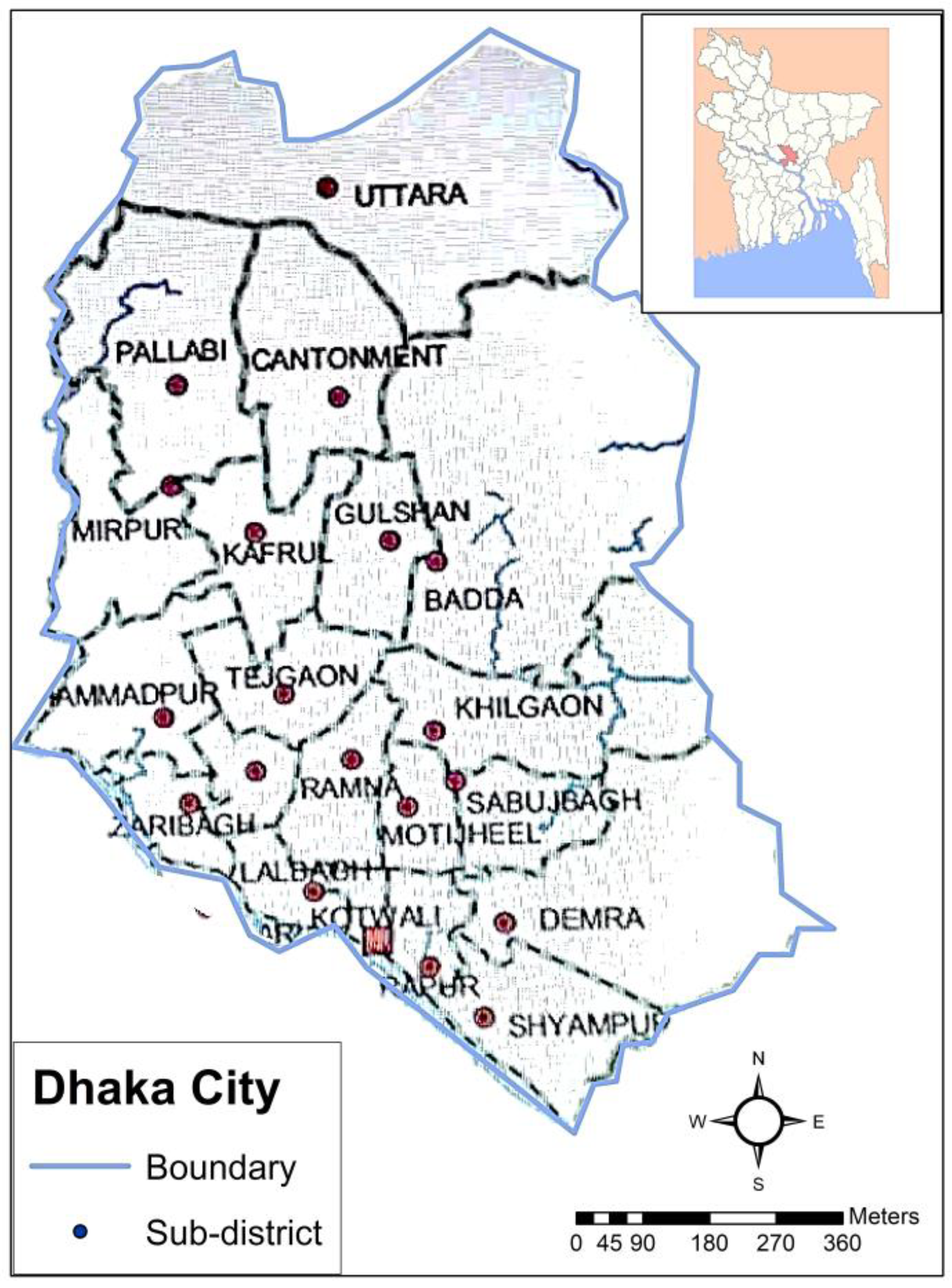
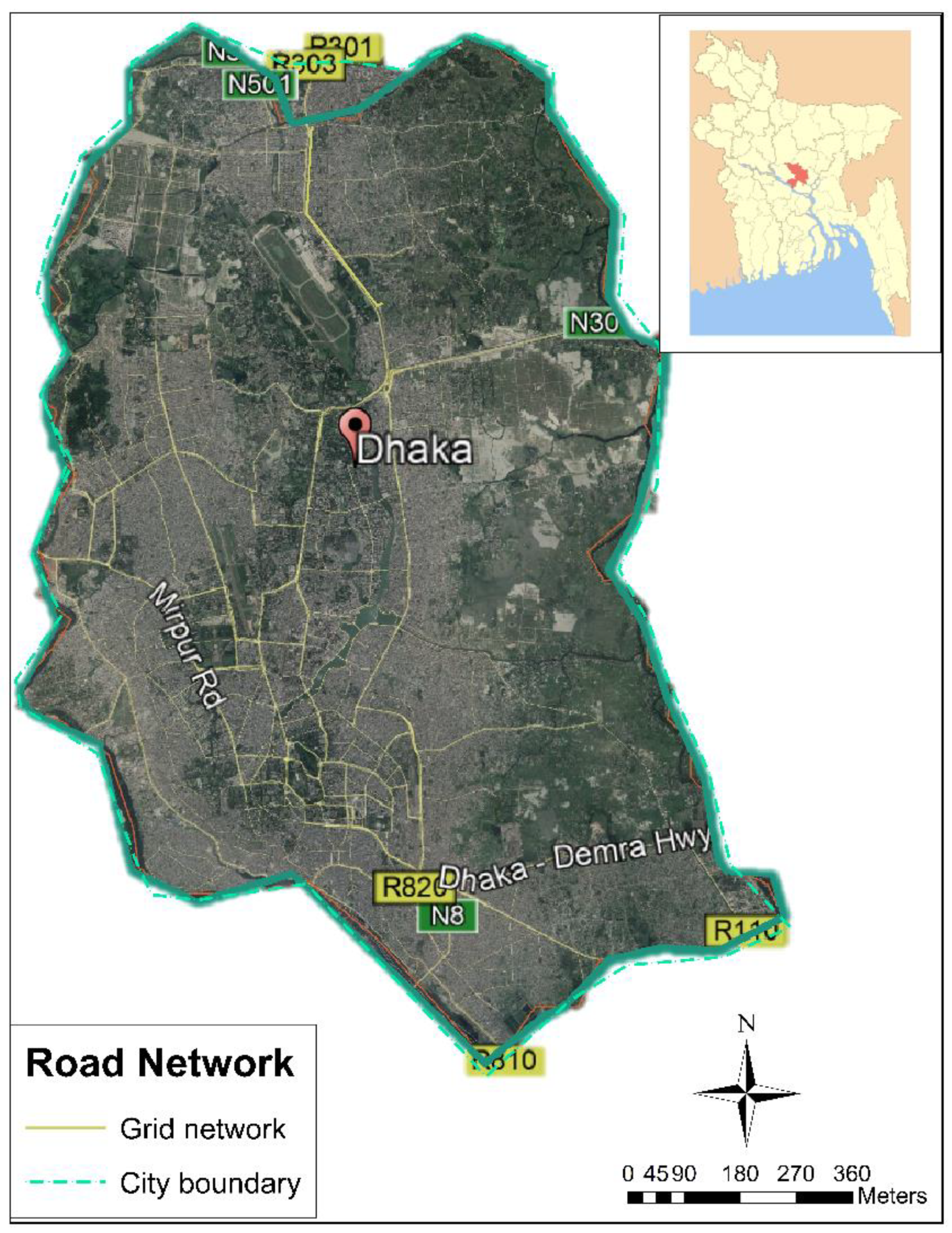
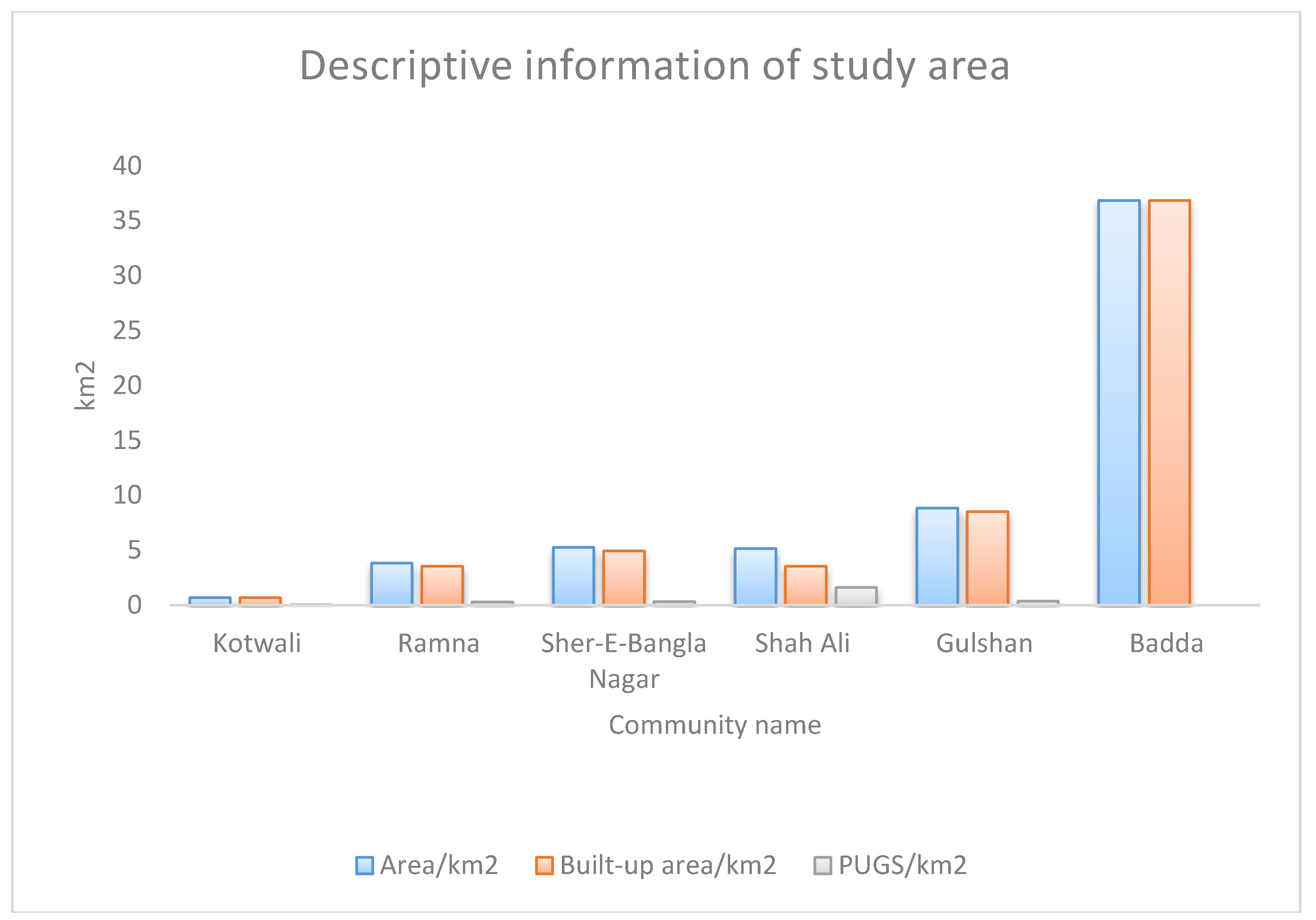
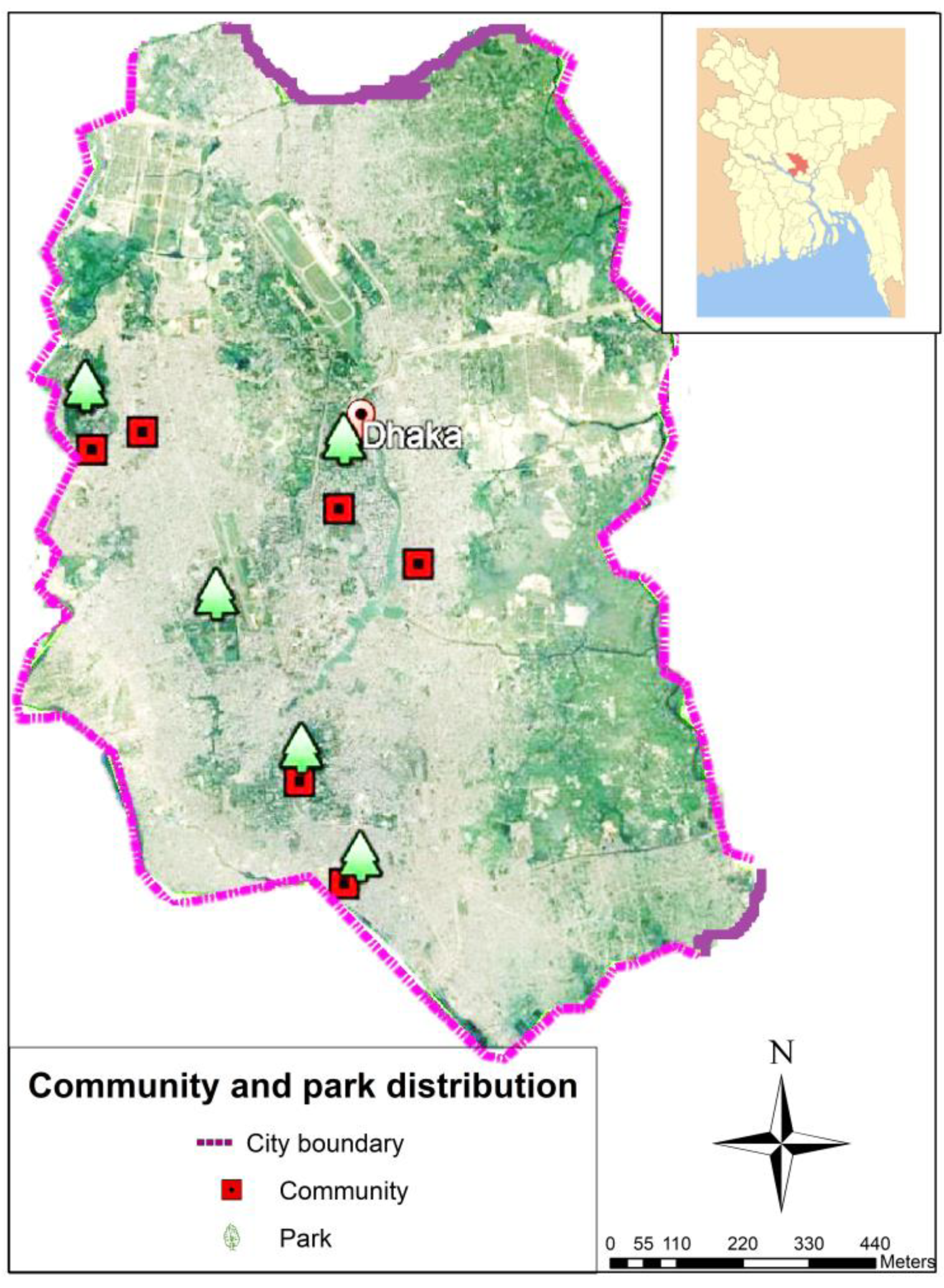
2.6. Study Sites Overview
2.7. Six Selected Community Areas
2.8. Sampling
2.9. Data Collection and Process
3. Results
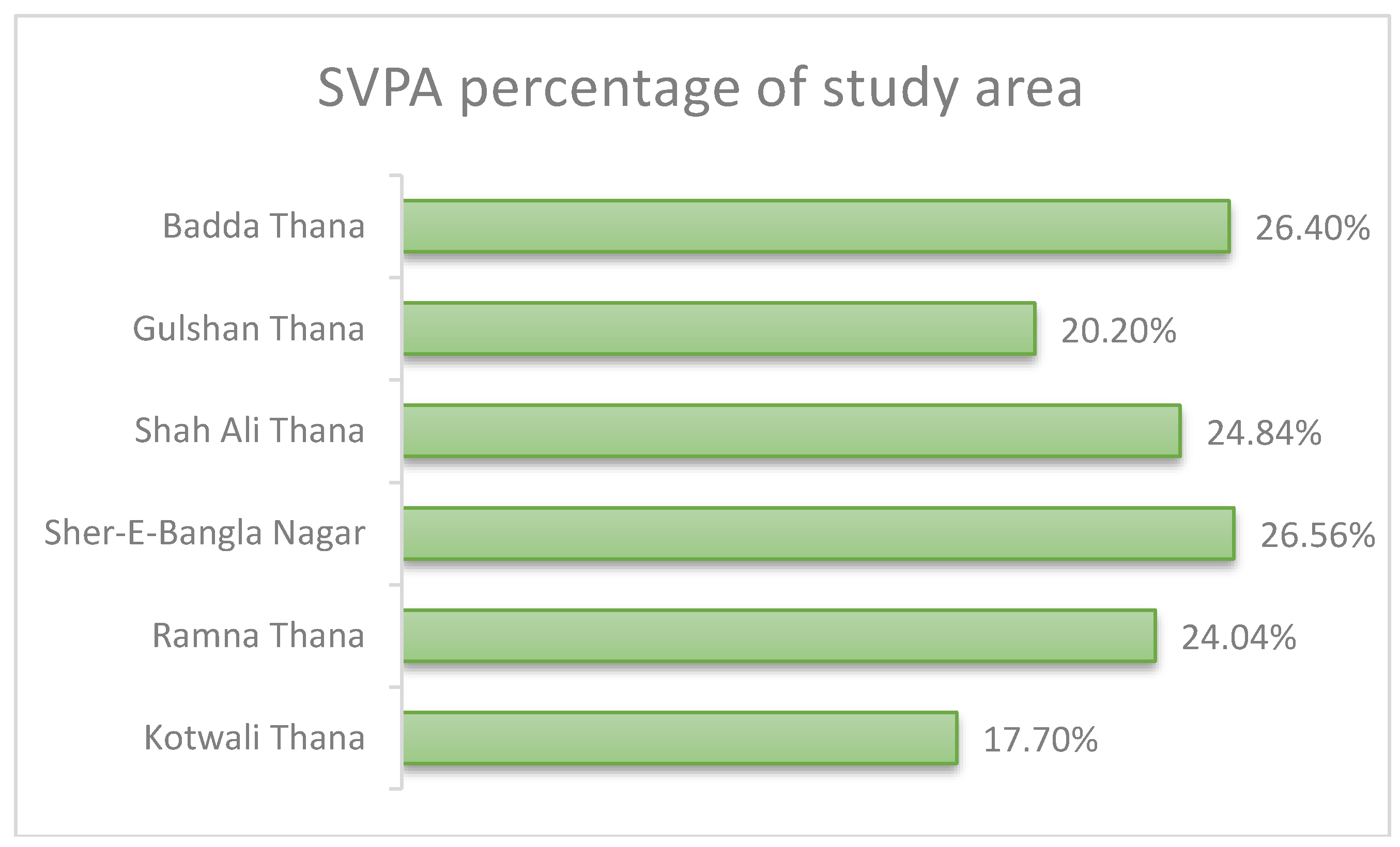
Spatial Equity Measure
4. Discussion
- How to develop a ‘green space creation model’ for women and children in the densely populated urban communities?
5. Conclusions
Author Contributions
Funding
Acknowledgments
Conflicts of Interest
References
- Klaufus, C.; van Lindert, P.; van Noorloos, F.; Steel, G. All-Inclusiveness versus Exclusion: Urban Project Development in Latin America and Africa. Sustainability 2017, 9. [Google Scholar] [CrossRef]
- Kothencz, G.; Kolcsár, R.; Cabrera-Barona, P.; Szilassi, P. Urban Green Space Perception and Its Contribution to Well-Being. Int. J. Environ. Res. Public Health 2017, 14. [Google Scholar] [CrossRef] [PubMed]
- Lee, A.C.K.; Maheswaran, R. The health benefits of urban green spaces: A review of the evidence. J. Public Health 2011, 33, 212–222. [Google Scholar] [CrossRef] [PubMed]
- Maas, J.; Verheij, R.A.; Groenewegen, P.P.; de Vries, S.; Spreeuwenberg, P. Green space, urbanity, and health: How strong is the relation? J. Epidemiol. Commun. Health 2009, 60, 587–592. [Google Scholar] [CrossRef] [PubMed]
- Liu, Y.; Wang, Y.; Peng, J.; Du, Y.; Liu, X.; Li, S.; Zhang, D. Correlations between Urbanization and Vegetation Degradation across the World’s Metropolises Using DMSP/OLS Nighttime Light Data. Remote Sens. 2015, 7. [Google Scholar] [CrossRef]
- Bowler, D.E.; Buyung-Ali, L.M.; Knight, T.M.; Pullin, A.S. A Systematic Review of Evidence for the Benefits to Healthcare of Exposure to Natural Environments. BMC Public Health 2010, 10, 456. [Google Scholar] [CrossRef] [PubMed]
- Cohen, G.L.; Sherman, D.K. Psychology of Change: Self-Affirmation and Socio-Psychological Intervention. Annu. Rev. Psychol. 2014, 65, 333–371. [Google Scholar] [CrossRef] [PubMed]
- Escobedo, F.J.; Kroeger, T.; Wagner, J.E. Urban Forest and Pollution Mitigation: Analyzing Ecosystem Service and Disservice. Environ. Pollut. 2011, 159, 2078–2087. [Google Scholar] [CrossRef] [PubMed]
- Hamada, S.; Ohta, T. Seasonal variations amid the cooling effect of urban green areas on nearby surrounding urban areas. Urban For. Urban Green. 2010, 9, 15–24. [Google Scholar] [CrossRef]
- Costanza, R.; Limburg, K.; Naeem, S.; O’Neill, R.V.; Paruelo, J.; Raskin, R.G.; Sutton, P. The value of the world’s ecosystem services and natural capital. Nature 1997, 387, 8. [Google Scholar] [CrossRef]
- Madureira, H.; Nunes, F.; Oliveira, J.V.; Madureira, T. Preferences for Urban Green Space Characteristics-A Comparative Study in Three Cities of Portuguese. Environments 2018, 5, 23. [Google Scholar] [CrossRef]
- Arnberger, A.; Eder, R. Are urban visitors’ general preferences for green-spaces similar to their preferences while seeking stress relief? Urban For. Urban Green. 2015, 14, 872–882. [Google Scholar] [CrossRef]
- Chen, J.; Chang, Z. Rethinking Urban Green Space Accessibility: Evaluating and Optimizing Public Transportation System through Social Network Study in Megacities. Landsc. Urban Plan. 2015, 143, 150–159. [Google Scholar] [CrossRef]
- Coolen, H.; Meesters, J. Private and Public Green Spaces: Meaningful but Different Settings. J. Hous. Built Environ. 2011, 27, 49–67. [Google Scholar] [CrossRef]
- Madureira, H.; Andresen, T.; Monteiro, A. Green Structure and Planning Evolution in Porto. Urban For. Urban Green. 2011, 10, 141–149. [Google Scholar] [CrossRef]
- Shanahan, D.F.; Lin, B.B.; Bush, R.; Gaston, K.J.; Dean, J.H.; Barber, E.; Fuller, R.A. Toward Improved Health Outcomes from Urban Nature. Am. J. Public Health 2015, 105, 470–477. [Google Scholar] [CrossRef] [PubMed]
- Kabisch, N.; Qureshi, S.; Haase, D. Human-environment interactions in urban green spaces: A systematic review of contemporary issues and prospects for future research. Environ. Impact Asses. 2015, 50, 25–34. [Google Scholar] [CrossRef]
- Richardson, E.A.; Mitchell, R.; Hartig, T.; de Vries, S.; Astell-Burt, T.; Frumkin, H. Green cities and health: A question of scale? J. Epidemiol. Commun. Health 2012, 66, 160. [Google Scholar] [CrossRef] [PubMed]
- White, M.P.; Alcock, I.; Wheeler, B.W.; Depledge, M.H. Would You Be Happier Living in a Greener Urban Area? A Fixed-Effects Analysis of Panel Data. 2013. Available online: http://journals.sagepub.com/doi/abs/10.1177/0956797612464659#articleShareContainer (accessed on 19 September 2018).
- Elmqvist, T.; Setälä, H.; Handel, S.N.; van der Ploeg, S.; Aronson, J.; Blignaut, J.N.; Gómez-Baggethun, E.; Nowak, D.J.; Kronenberg, J.; de Groot, R. Benefits of restoring ecosystem services in urban areas. Curr. Opin. Environ. Sustain. 2015, 14, 101–108. [Google Scholar] [CrossRef]
- Hartig, T.; Mitchell, R.; de Vries, S.; Frumkin, H. Nature and Health. Annu. Rev. Public Health 2014, 35, 207–228. [Google Scholar] [CrossRef] [PubMed]
- Keniger, L.E.; Gaston, K.J.; Irvine, K.N.; Fuller, R.A. What are the Benefits of Interacting with Nature? Int. J. Environ. Res. Public Health 2013, 10, 913–935. [Google Scholar] [CrossRef] [PubMed]
- Chiesura, A. The role of urban public parks for the sustainable city. Landsc. Urban Plan. 2004, 68, 129–138. [Google Scholar] [CrossRef]
- Landers, D.H.; Nahlik, A.M. Final Ecosystem Goods and Services Classification System (FEGS-CS); (EPA/600/R-13/ORD-004914); U.S. Environmental Protection Agency, Office of Research and Development: Washington, DC, USA, 2013.
- Tsai, W.-L.; McHale, R.M.; Jennings, V.; Marquet, O.; Hipp, A.J.; Leung, Y.-F.; Floyd, F.M. Relationships between Characteristics of Urban Green Land Cover and Mental Health in U.S. Metropolitan Areas. Int. J. Environ. Res. Public Health 2018, 15. [Google Scholar] [CrossRef] [PubMed]
- Wolch, J.R.; Byrne, J.; Newell, J.P. Urban Green Space, Public Health, and Environmental Justice- the Challenge of Making Cities ‘Just Green Enough’ . Landsc. Urban Plan. 2014, 125, 234–244. [Google Scholar] [CrossRef]
- Gong, F.; Zheng, Z.-C.; Ng, E. Modeling Elderly Accessibility to Urban Green Space in High-Density Cities: A Case Study of Hong Kong. Procedia Environ. Sci. 2016, 36, 90–97. [Google Scholar] [CrossRef]
- Barbosa, O.; Tratalos, J.A.; Armsworth, P.R.; Davies, R.G.; Fuller, R.A.; Johnson, P.; Gaston, K.J. Who Benefits from Access to Green Space? A Case Study of Sheffield, UK. Landsc. Urban Plan. 2007, 83, 187–195. [Google Scholar] [CrossRef]
- Kardan, O.; Gozdyra, P.; Misic, B.; Moola, F.; Palmer, L.J.; Paus, T.; Berman, M.G. Neighborhood Green Space, and Health in a Large Urban Setting. Sci. Rep. 2015, 5, 11610. [Google Scholar] [CrossRef] [PubMed]
- Lindsey, G.; Maraj, M.; Kuan, S.C. Access, Equity, and Urban Greenways: An Exploratory Investigation. Prof. Geogr. 2001, 53, 332–346. [Google Scholar] [CrossRef]
- Yuan, Y.; Xu, J.; Wang, Z. Spatial Equity Measure on Urban Ecological Space Layout Based on the Accessibility of Socially Vulnerable Groups: A Case Study of Changting, China. Sustainability 2017, 9, 1552. [Google Scholar] [CrossRef]
- Talen, E.; Anselin, L. Assessing spatial equity: An evaluation of the measures of accessibility to public playgrounds. Environ. Plan. 1998, 30, 595–613. [Google Scholar] [CrossRef]
- Rao, N.D.; Min, J. Decent Living Standards: Material Prerequisites for Human Wellbeing. Soc. Indic. Res. 2018, 138, 225–244. [Google Scholar] [CrossRef] [PubMed]
- Mitchell, R.K.; Busenitz, L.W.; Bird, B.; Gaglio, C.M.; McMullen, J.S.; Morse, E.A.; Smith, J.B. The Central Question in Entrepreneurial Cognition Research 2007. Entrep. Theory Pract. 2007, 31, 1–27. [Google Scholar] [CrossRef]
- Sugiyama, T.; Leslie, E.; Giles-Corti, B.; Owen, N. Associations of neighbourhood greenness with physical and mental health: Do walking, social coherence and local social interaction explain the relationships? J. Epidemiol. Commun. Health 2008, 62, e9. [Google Scholar] [CrossRef]
- Hunter, C.; Fitzpatrick, R.; Jenkinson, C.; Darlington, A.-S.E.; Coulter, A.; Forder, J.E.; Peters, M. Perspectives from health, social care and policy stakeholders on the value of a single self-report outcome measure across long-term conditions: A qualitative study. BMJ Open 2015, 5, e006986. [Google Scholar] [CrossRef] [PubMed]
- Fan, P.; Xu, L.; Yue, W.; Chen, J. Accessibility of Public Urban Green Space in an Urban Periphery: The Case of Shanghai. Landsc. Urban Plan. 2017, 165, 177–192. [Google Scholar] [CrossRef]
- de Vries, A.L.C.; McGuire, J.K.; Steensma, T.D.; Wagenaar, E.C.F.; Doreleijers, T.A.H.; Cohen-Kettenis, P.T. Young adult psychological outcome after puberty suppression and gender reassignment. Pediatrics 2014, 134, 696–704. [Google Scholar] [CrossRef] [PubMed]
- Sadler, D.R. Beyond feedback: Developing student capability in complex appraisal. Assess. Eval. Higher Educ. 2010, 35, 535–550. [Google Scholar] [CrossRef]
- Papa, F.; Prigent, C.; Aires, F.; Jimenez, C.; Rossow, W.B.; Matthews, E. Interannual variability of surface water extent at the global scale, 1993–2004. J. Geophys. Res. 2010, 115. [Google Scholar] [CrossRef]
- Hansen, W.G. How Accessibility Shapes Land Use. J. Am. Inst. Planners 1959, 25, 73–76. [Google Scholar] [CrossRef]
- Ingram, D.R. The concept of accessibility: A search for an operational form. Reg. Stud. 1971, 5, 101–107. [Google Scholar] [CrossRef]
- Dalvi, M.Q.; Martin, K.M. The Measurement of Accessibility: Some Preliminary Results. Transportation 1976, 5, 17–42. [Google Scholar] [CrossRef]
- Morris, J.M.; Dumble, P.L.; Wigan, M.R. Accessibility Indicators of Transport Planning. Transp. Res. Part A Gen. 1979, 13, 91–109. [Google Scholar] [CrossRef]
- Van Wee, B.; van Cranenburgh, S. Substitutability as a concept to understand travel behavior, and its implications. In Proceedings of the BIVEC-GIBET Transport Research Days 2017: Towards an Autonomous and Interconnected Transport Future, Liège, Belgium, 18 May 2017; pp. 1–18. [Google Scholar]
- Ferreira, R.; Eberharter, A.; Bonaldi, T.; Chioda, M.; Imhof, A.; Becker, P.B. Site-specific acetylation of ISWI by GCN5. BMC Mol. Biol. 2007, 8, 73. [Google Scholar] [CrossRef] [PubMed]
- Zhou, X.; Parves, R.M. Social benefits of urban green space-a conceptual framework of valuation and accessibility measurements. Manag. Environ. Qual. Int. J. 2012, 23, 173–189. [Google Scholar] [CrossRef]
- Heynen, N.; Perkins, H.A.; Roy, P. The Political Ecology of Uneven Urban Green Space: The Impact of Political Economy on Race and Ethnicity in Producing Environmental Inequality in Milwaukee. Urban Aff. Rev. 2006, 42, 3–25. [Google Scholar] [CrossRef]
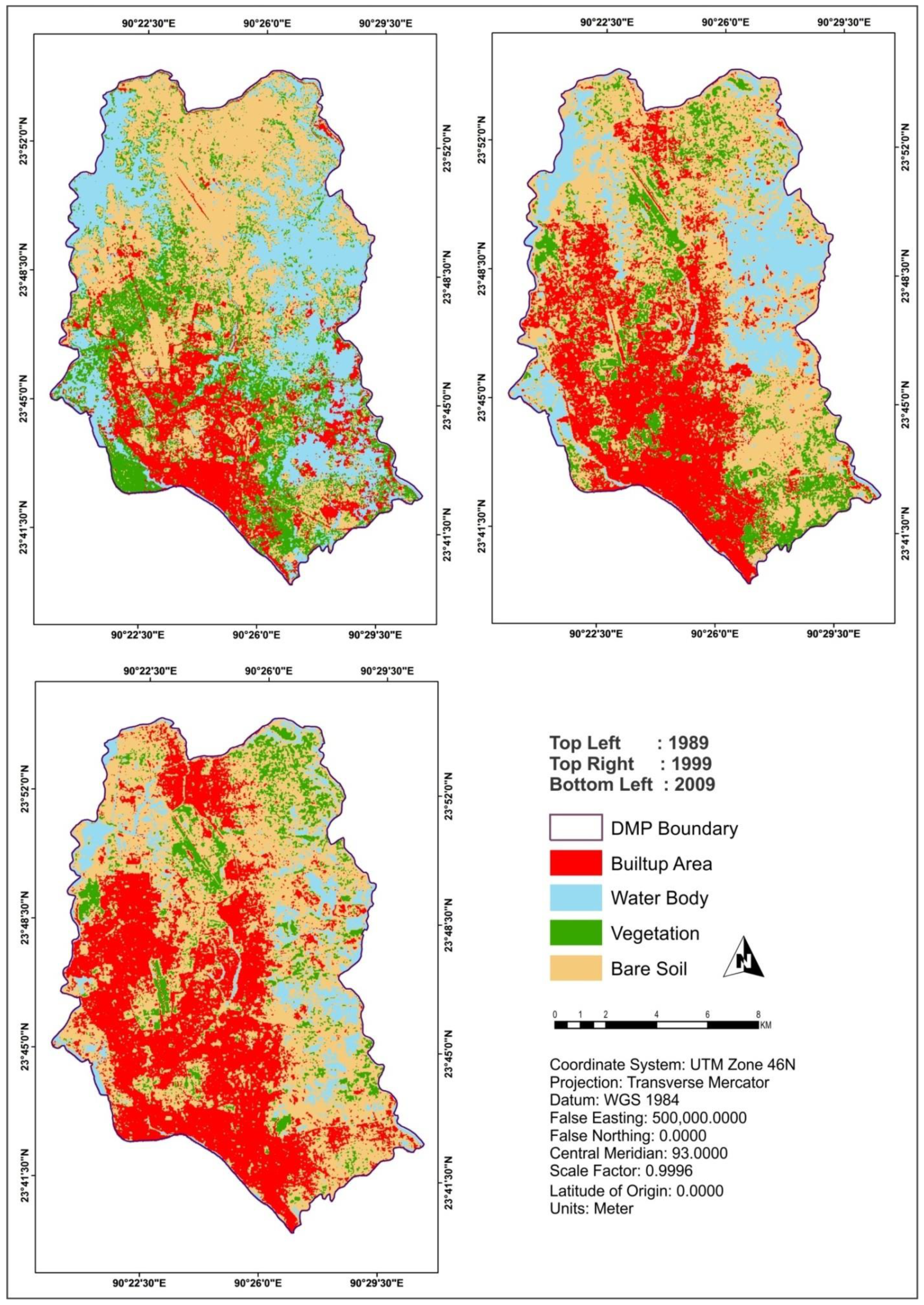
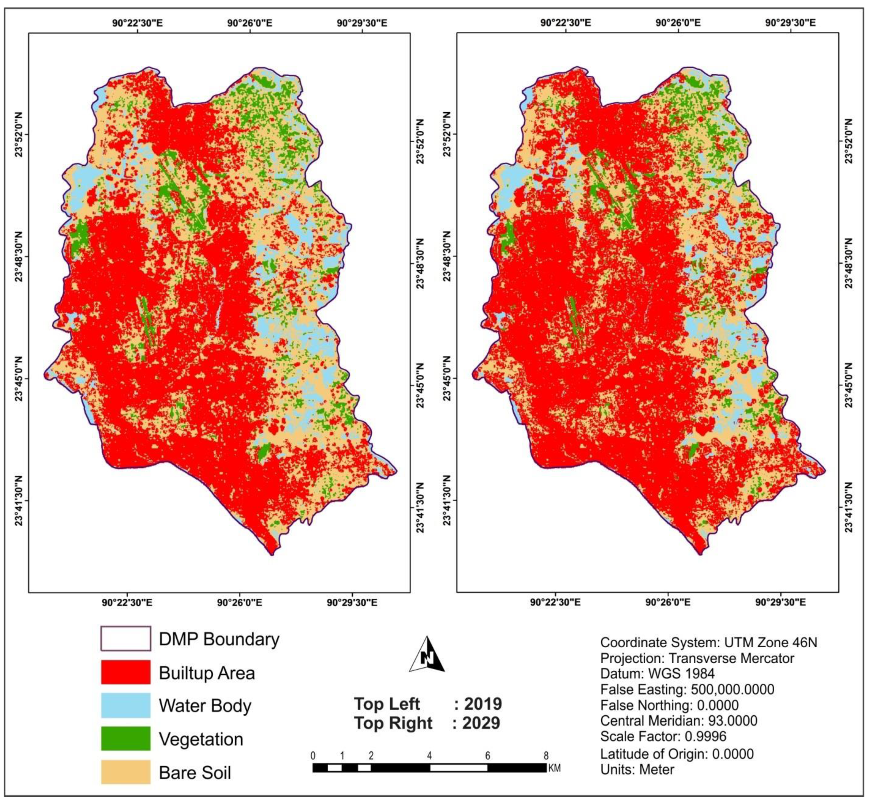
- Byomkesh, T.; Nakagoshi, N.; Dewan, A.M. Urbanization and green space dynamics in Greater Dhaka, Bangladesh. Landsc. Ecol. Eng. 2012, 8, 45–58. [Google Scholar] [CrossRef]
- United Nations Environment Programme (UNEP). Annual Report; UNEP: Nairobi, Kenya, 2006. [Google Scholar]
- Dewan, A.M.; Yamaguchi, Y. Using remote sensing and GIS to detect and monitor land use and land cover change in Dhaka Metropolitan of Bangladesh during 1960–2005. Environ. Monit. Assess. 2008, 150, 237. [Google Scholar] [CrossRef] [PubMed]
- Bangladesh Center for Advanced Studies, BCAS. Report on local level environmental governance. In Delegation of the European Commission; BCAS: Dhaka, Bangladesh, 2006. [Google Scholar]
- Francis, C.; Lieblein, G.; Gliessman, S.; Breland, T.A.; Creamer, N.; Harwood, R.; Salomonsson, L.; Helenius, J.; Rickerl, D.; Salvador, R.; et al. Agroecology: The Ecology of Food Systems. J. Sustain. Agric. 2003, 22, 99–118. [Google Scholar] [CrossRef]
- Bai, X.; Fernandez, I.S.; McMullan, G.; Scheres, S.H. Ribo-some Structures to Near-Atomic Resolution from Thirty Thousand Cryo-EM Particles. eLife 2013, 2, e00461. [Google Scholar] [CrossRef] [PubMed]
- Shakil, M.R.H. Systematic Persecution of Religious Minorities: Bangladesh Perspective. IOSR J. Hum. Soc. Sci. 2013, 7, 9–17. [Google Scholar] [CrossRef]
- Mechanic, D.; Tanner, J. Vulnerable people, groups, and populations: Societal view. Health Aff. (Millwood) 2007, 26, 1220–1230. [Google Scholar] [CrossRef] [PubMed]
- Aday, L.A. At Risk in America: The Health and Health Care Needs of Vulnerable Populations in the United States; Jossey-Bass Publishers: San Francisco, CA, USA, 1993. [Google Scholar]
- The daily Star. Dhaka, Asia’s Most Stressful City; The Daily Star: Dhaka, Bangladesh, 2017; Available online: https://www.thedailystar.net/editorial/dhaka-asias-most-stressful-city-1470055 (accessed on 8 October 2018).
- The Daily Star. Pollution the Killer; The Daily Star: Dhaka, Bangladesh, 2018; Available online: https://www.thedailystar.net/environment/environment-pollution-in-dhaka-bangladesh-18000-died-world-bank-report-1634566 (accessed on 6 October 2018).
- Segura-Ortí, E.; Martínez-Olmos, F.J. Test-Retest Reliability and Minimal Detectable Change Scores for Sit-to-Stand-to-Sit Tests, the Six-Minute Walk Test, the One-Leg Heel-Rise Test, and Handgrip Strength in People Undergoing Hemodialysis. Phys. Ther. 2011, 91, 1244–1252. [Google Scholar] [CrossRef] [PubMed]
- Khan, M. A Study of Open Spaces in the Context of Dhaka City for Sustainable Use: A Syntactic Approach. Int. J. Adv. Eng. Tech. 2014, 6, 238–243. [Google Scholar] [CrossRef]
- Nilufar, M. Social Inter-Mediation: Towards Gaining Access to Water for Squatter Communities in Dhaka (English); Water and Sanitation Program; World Bank: Washington, DC, USA, 1999; Available online: http://documents.worldbank.org/curated/en/101921468205459871/Social-inter-mediation-towards-gaining-access-to-water-for-squatter-communities-in-Dhaka (accessed on 25 April 2018).
- Zhang, Y.J.; Tarrant, M.A.; Green, G.T. The importance of differentiating urban and rural phenomena in examining the unequal distribution of locally desirable land. J. Environ. Manag. 2008, 88, 1314–1319. [Google Scholar] [CrossRef] [PubMed]
- Tian, Y.; Jim, Y.C.; Liu, Y. Using a Spatial Interaction Model to Assess the Accessibility of District Parks in Hong Kong. Sustainability 2017, 9. [Google Scholar] [CrossRef]
- Chen, J.; Chang, Z. Rethinking urban green space accessibility: Evaluating and optimizing public transportation system through social network analysis in megacities. Landsc. Urban Plan. 2015, 150–159. [Google Scholar] [CrossRef]
- Ekkel, E.D.; de Vries, S. Nearby Green Space and Human Healthcare- Evaluating Accessibility Metrics. Landsc. Urban Plan. 2017, 157, 214–220. [Google Scholar] [CrossRef]
- Mannan, H.; ElTayeb, S.; MacLachlan, M.; Amin, M.; McVeigh, J.; Munthali, A.; Van Rooy, G. Core concepts of human rights and inclusion of vulnerable groups in the mental health policies of Malawi, Namibia, and Sudan. Int. J. Ment. Health Syst. 2013, 7, 7. [Google Scholar] [CrossRef] [PubMed]
- Self-selected gait speed: A critical clinical outcome. Available online: http://lermagazine.com/article/self-selected-gait-speed-a-critical-clinical-outcome (accessed on 17 October 2018).
- Flaskerud, J.H.; Winslow, B.J. Conceptualizing vulnerable populations’ health-related research. Nurs. Res. 1998, 47, 69–78. [Google Scholar] [CrossRef] [PubMed]
- Douka, K.; Bergman, C.A.; Hedges, R.E.M.; Wesselingh, F.P.; Higham, T.F.G. Chronology of Ksar Akil (Lebanon) and implications for the colonization of Europe by anatomically modern humans. PLoS ONE 2013, 8, e72931. [Google Scholar] [CrossRef] [PubMed]
- Huang, C.; Yang, J.; Lu, H.; Huang, H.; Yu, L. Green Spaces as an Indicator of Urban Health: Evaluating Its Changes in 28 Mega-Cities. Remote Sens. 2017, 9, 1266. [Google Scholar] [CrossRef]
- World Health Organization (WHO). Urban Green Spaces and Health: A Survey of Evidence; World Wellbeing Organization: Geneva, Switzerland, 2016. [Google Scholar]
- Annerstedt van den Bosch, M.; Mudu, P.; Uscila, V.; Barrdahl, M.; Kulinkina, A.; Staatsen, B.; Swart, W.; Kruize, H.; Zurlyte, I.; Egorov, A.I. Development of an urban green space indicator and the public health rationale. Scand. J. Public Health 2016, 44, 159–167. [Google Scholar] [CrossRef] [PubMed]
- Yin, H.W.; Kong, F.H.; Zong, Y.G. Accessibility and equity assessment on urban green space. Acta Ecol. Sin. 2008, 28, 3375–3383. [Google Scholar]
- Bangladesh Bureau of Statistics (BBS). National Population and Housing Census 2011; BBS: Dhaka, Bangladesh, 2015. [Google Scholar]
- World Bank. A Modern Dhaka Is Key to Bangladesh’s Upper-Middle Income Country Vision; World Bank: Washington, DC, USA, 2017; Available online: https://www.worldbank.org/en/news/press-release/2017/07/19/modern-dhaka-key-bangladesh-upper-middle-income-country-vision (accessed on 10 September 2018).
- Dhaka City Corporation (DCC). Municipal Services and Performance; DCC: Dhaka, Bangladesh, 2013. Available online: http://www.dncc.gov.bd/site/page/c0b6953f-16d3-405b-85e9-dece13bb98de/%E0%A6%B2%E0%A7%8B%E0%A6%95%E0%A7%87%E0%A6%B6%E0%A6%A8-%E0%A6%93-%E0%A6%85%E0%A6%BE%E0%A7%9F%E0%A6%A4%E0%A6%A8 (accessed on 12 September 2018).
- Swapan, S.M.; Zaman, U.A.; Ahsan, T.; Ahmed, F. Transforming Urban Dichotomies and Challenges of South Asian Megacities: Rethinking Sustainable Growth of Dhaka, Bangladesh. Urban Sci. 2017, 1. [Google Scholar] [CrossRef]
- Hough, M. Cities and Natural Process; Rutledge: London, UK, 2004; pp. 64–65. ISBN 0-415-29855-5. [Google Scholar]
- Mondal, M.A.L. Trends of Urbanization in Bangladesh. The Daily Star. 20 September 2006. Available online: http://archive.thedailystar.net/suppliments/2006/15thanniv/ourcities/ourcities28.htm (accessed on 26 October 2018).
- Ahmed, B.; Kamruzzaman, M.; Zhu, X.; Rahman, M.; Choi, K. Simulating Land Cover Changes and Their Impacts on Land Surface Temperature in Dhaka, Bangladesh. Remote Sens. 2013, 5, 5969–5998. [Google Scholar] [CrossRef]
- Asia Times. Planet of Slums by Mike Davis. Asia Times. 20 May 2006. Available online: http://www.atimes.com/atimes/Front_Page/HE20Aa01.html (accessed on 8 May 2010).
- Bangladesh Bureau of Statistics (BBS). 2011 Population and Housing Census: Preliminary Results; BBS: Dhaka, Bangladesh, 2012. Available online: http://bbs.portal.gov.bd/sites/default/files/files/bbs.portal.gov.bd/page/7b7b171a_731a_4854_8e0a_f8f7dede4a4a/PHC2011PreliminaryReport.pdf (accessed on 8 September 2018).
- Yong, M.S.; Yaftian, N.; Griffiths, S.; Brink, J.; Robertson, T.; D’Orsogna, L.; Weintraub, R.G.; d’Udekem, Y.; Brizard, C.P.; Konstantinov, I.E. Long-Term Outcomes of Total Anomalous Pulmonary Venous Drainage Repair in Neonates and Infants. Ann. Thorac. Surg. 2018, 105, 1232–1238. [Google Scholar] [CrossRef] [PubMed]
- Ahmed, S. Cluster Sampling. Johns Hopkins University: Baltimore, MD, USA, 2009. Available online: http://ocw.jhsph.edu/courses/StatMethodsForSampleSurveys/PDFs/Lecture5.pdf (accessed on 20 October 2018).
- Kim, S.T.; Cristescu, R.; Bass, A.J.; Kim, K.-M.; Odegaard, J.I.; Kim, K.; Liu, X.Q.; Sher, X.; Jung, H.; Lee, M.; et al. Comprehensive molecular characterization of clinical responses to PD-1 inhibition in metastatic gastric cancer. Nat. Med. 2018, 24, 1449. [Google Scholar] [CrossRef] [PubMed]
- Tabassum, S.; Sharmin, F. Accessibility Analysis of Parks at Urban Neighborhood: The Case of Dhaka. Asian J. Appl. Sci. Eng. 2013, 2, 148–160. [Google Scholar]
- Xue, F.; Gou, Z.; Lau, S. The Green Open Space Development Model and Associated Use Behaviors in Dense Urban Settings: Lessons from Hong Kong and Singapore. Urban Des. Int. 2017, 22, 287–302. [Google Scholar] [CrossRef]
- Zhu, Y.; Ding, J.; Zhu, Q.; Cheng, Y.; Ma, Q.; Ji, X. The Impact of Green Open Space on Community Attachment—A Case Study of Three Communities in Beijing. Sustainability 2017, 9. [Google Scholar] [CrossRef]
- Wüstemann, H.; Kalisch, D.; Kolbe, J. Access to urban green space and environmental inequalities in Germany. Landsc. Urban Plan. 2017, 164, 124–131. [Google Scholar] [CrossRef]
- Žlender, V.; Ward Thompson, C. Accessibility and use of peri-urban green space for inner-city dwellers: A comparative study. Landsc. Urban Plan. 2017, 165, 193–205. [Google Scholar] [CrossRef]
- Gupta, K.; Roy, A.; Luthra, K.; Maithani, S. Mahavir GIS based analysis for assessing the accessibility at hierarchical levels of urban green spaces. Urban For. Urban Green. 2016, 18, 198–211. [Google Scholar] [CrossRef]
- La Rosa, D. Accessibility to green spaces: GIS based indicators for sustainable planning in a dense urban context. Ecol. Indic. 2014, 42, 122–134. [Google Scholar] [CrossRef]
- ULI and CLC. 10 Principles for Liveable High-Density Cities: Lessons from Singapore; Centre for Liveable Cities and Urban Land Institute: Singapore, 2013. [Google Scholar]
- Kolczak, A. This City Aims to Be the World’s Greenest: As Singapore expands, a novel approach preserves green space. National Geographic. 28 February 2017. Available online: https://www.nationalgeographic.com/environment/urban-expeditions/green-buildings/green-urban-landscape-cities-Singapore/ (accessed on 10 September 2018).
- Rahman, M.; Reza, S.; Islam, M.; Rahman, A.; Nath, A. Prevalence of Obesity and Overweight among English Medium School Children of Dhaka City in Bangladesh. J. Environ. Sci. Nat. Resour. 2015, 7. [Google Scholar] [CrossRef]
- Chowdhury, M.A.B.; Uddin, M.J.; Khan, H.M.R.; Haque, M.R. Type 2 diabetes and its correlates among adults in Bangladesh: A population based study. BMC Public Health 2015, 15, 1070. [Google Scholar] [CrossRef] [PubMed]
- Lytras, D.M.; Visvizi, A. Who Uses Smart City Services and What to Make of It: Toward Interdisciplinary Smart Cities Research. Sustainability 2018, 10. [Google Scholar] [CrossRef]
- Banglapedia. Dhaka. Banglapedia- National Encyclopedia of Bangladesh: Dhaka, Bangladesh, December 2014; Available online: http://en.banglapedia.org/index.php?title=Dhaka (accessed on 5 October 2018).
- Visvizi, A.; Lytras, M.D. Rescaling and refocusing smart cities research: From mega cities to smart villages. J. Sci. Technol. Policy Manag. 2018, 9, 134–145. [Google Scholar] [CrossRef]


| Community | Proportion of the Female Population | Proportion of the Illiterate Population | Proportion of the Religious Minority Population | Proportion of the Ethnic Minority Population | Proportion of the Unemployed Population |
|---|---|---|---|---|---|
| Kotwali Thana | 35.10% | 27% | 2.50% | 0.30% | 23.60% |
| Ramna Thana | 46.10% | 27.70% | 16.90% | 0.10% | 29.60% |
| Sher-e-Bangla Nagar Thana | 44.80% | 21.80% | 29.90% | 0.10% | 36.20% |
| Shah Ali Thana | 46.50% | 29% | 21.10% | 0.10% | 27.40% |
| Gulshan Thana | 44.50% | 25.20% | 4.70% | 0.20% | 26.40% |
| Badda Thana | 43.70% | 27.70% | 5.30% | 0.20% | 26.40% |
| Community | PUGS (m2/per Capita) |
|---|---|
| Kotwali | 0.0005 m2 |
| Ramna | 0.017 m2 |
| Sher-e-Bangla Nagar | 0.025 m2 |
| Shah Ali | 0.15 m2 |
| Gulshan | 0.015 m2 |
| Badda | 0 m2 |
| Time (Min) | <2 min | 2–5 min | 5–10 min | 10–20 min | |
|---|---|---|---|---|---|
| Accessibility Level | Very Good | Good | Common | Poor | |
| Kotwali Thana | Proportion (%) | 2.01 | 17 | 15 | 0 |
| Ramna Thana | Proportion (%) | 0.78 | 6.52 | 12.24 | 13.8 |
| Sher-e-Bangla Nagar | Proportion (%) | 0.58 | 5.97 | 8.95 | 9.52 |
| Shah Ali Thana | Proportion (%) | 0.61 | 4.5 | 9.13 | 7.13 |
| Gulshan Thana | Proportion (%) | 0.34 | 3 | 5.2 | 7.68 |
| Badda Thana | Proportion (%) | 0.08 | 0.68 | 1.28 | 5.57 |
| Community | Total Population | Population Density | Accessible Population | UGSI (%) |
|---|---|---|---|---|
| Kotwali Thana | 145,431 | 98,898 | 29,086.20 | 20 |
| Ramna Thana | 195,167 | 50,824 | 24,395.88 | 12.5 |
| Sher-E-Bangla Nagar | 137,573 | 26,202 | 16,185.05 | 11.76 |
| Shah Ali Thana | 115,489 | 22,425 | 12,156.74 | 10.53 |
| Gulshan Thana | 253,050 | 28,593 | 25,305 | 11.96 |
| Badda Thana | 536,621 | 14,566 | 51,106.76 | 9.52 |
| SDI Classification | SDI > 0.6 | 0.5 < SDI < 0.6 | 0.4 < SDI < 0.5 |
|---|---|---|---|
| Demand Level | Very High | High | Low |
| Kotwali Thana | 0.51 | ||
| Ramna Thana | 0.52 | ||
| Sher-e-Bangla Nagar | 0.61 | ||
| Shah Ali Thana | 0.53 | ||
| Gulshan Thana | 0.45 | ||
| Badda Thana | 0.47 |
| Accessibility Level | Very Good Accessibility | Good Accessibility | Common Accessibility | Poor Accessibility | |
|---|---|---|---|---|---|
| SDI Classification | |||||
| Low demand (0.4 < SDI < 0.5) | Gulshan Badda | ||||
| High demand (0.5 <SDI < 0.6) | Kotwali | Ramna | Shah Ali | ||
| Very high demand (SDI > 0.6) | Sher-e-Bangla Nagar | ||||
© 2018 by the authors. Licensee MDPI, Basel, Switzerland. This article is an open access article distributed under the terms and conditions of the Creative Commons Attribution (CC BY) license (http://creativecommons.org/licenses/by/4.0/).
Share and Cite
Rahman, K.M.A.; Zhang, D. Analyzing the Level of Accessibility of Public Urban Green Spaces to Different Socially Vulnerable Groups of People. Sustainability 2018, 10, 3917. https://doi.org/10.3390/su10113917
Rahman KMA, Zhang D. Analyzing the Level of Accessibility of Public Urban Green Spaces to Different Socially Vulnerable Groups of People. Sustainability. 2018; 10(11):3917. https://doi.org/10.3390/su10113917
Chicago/Turabian StyleRahman, K M Atikur, and Dunfu Zhang. 2018. "Analyzing the Level of Accessibility of Public Urban Green Spaces to Different Socially Vulnerable Groups of People" Sustainability 10, no. 11: 3917. https://doi.org/10.3390/su10113917
APA StyleRahman, K. M. A., & Zhang, D. (2018). Analyzing the Level of Accessibility of Public Urban Green Spaces to Different Socially Vulnerable Groups of People. Sustainability, 10(11), 3917. https://doi.org/10.3390/su10113917