The Moku System: Managing Biocultural Resources for Abundance within Social-Ecological Regions in Hawaiʻi

 ,
,  ,
,
Abstract
:1. Introduction
2. Methods
3. Results
4. Discussion
5. Conclusions
Author Contributions
Funding
Acknowledgments
Conflicts of Interest
References
- McMillen, H.; Ticktin, T.; Friedlander, A.; Jupiter, S.; Thaman, R.; Vietayaki, J.; Giambelluca, T.; Campbell, J.; Rupeni, E.; Apis-Overhoff, L.; et al. Small islands, valuable insights: systems of customary resource management and resilience in the Pacific. Ecol. Soc. 2014, 19, 44. [Google Scholar] [CrossRef]
- Delevaux, J.M.S.; Whittier, R.; Stamoulis, K.A.; Bremer, L.L.; Jupiter, S.; Friedlander, A.M.; Poti, M.; Guannel, G.; Kurashima, N.; Winter, K.B.; et al. A linked land-sea model framework to inform ridge-to-reef management in high oceanic islands. PLoS ONE 2018, 13, e0193230. [Google Scholar] [CrossRef] [PubMed]
- Ticktin, T.; Dacks, R.; Quazi, S.; Tora, M.; McGuigan, A.; Hastings, Z.; Naikatini, A. Significant linkages between measures of biodiversity and community resilience in Pacific Island agroforests. Conserv. Biol. 2018, in press. [Google Scholar] [CrossRef] [PubMed]
- Johannes, R.E. The renaissance of community-based marine resource management in Oceania. Annu. Rev. Ecol. Syst. 2002, 33, 317–340. [Google Scholar] [CrossRef]
- Tainter, J.A. Archaeology of overshoot and collapse. Annu. Rev. Anthropol. 2006, 35, 59–74. [Google Scholar] [CrossRef]
- Minton, N.; Ka’imikaua, J.K. A Mau A Mau: To Continue Forever; Oshita, R., Minton, N., Eds.; Nā Maka o ka ‘Āina (Vid): Nāʻālehu, HI, USA, 2000. [Google Scholar]
- Kamakau, S.M. Ka Hana a Ka Poe Kahiko; Bishop Museum Press: Honolulu, HI, USA, 1976. [Google Scholar]
- Handy, E.S.C.; Handy, E.G.; Pukui, M.K. Native Planters in Old Hawaii: Their Life, Lore, and Environment; Bishop Museum Press: Honolulu, HI, USA, 1972. [Google Scholar]
- Elbert, S.; Pukui, M.K. Hawaiian Dictionary; University of Hawaii Press: Honolulu, HI, USA, 1986. [Google Scholar]
- Kelly, M. Ahupuaʻa Fishponds and Lo‘i: A Film for Our Time; Nā Maka o ka ‘Āina: Nāʻālehu, HI, USA, 1992. [Google Scholar]
- Kelly, M. Changes in Land Tenure in Hawaii, 1778–1850. Master’s Thesis, University of Hawaii, Honolulu, HI, USA, 1956. [Google Scholar]
- Minerbi, L. Indigenous management models and protection of the ahupuaʻa. Soc. Process Hawaii 1999, 39, 208–225. [Google Scholar]
- Mueller-Dombois, D. The Hawaiian Ahupuaʻa Land Use System: Its Biological Resource Zones and the Challenge for Silvicultural Restoration. Bishop Mus. Bull. Cult. Environ. Stud. 2007, 3, 23–33. [Google Scholar]
- Andrade, C. Hā’ena: Through the Eyes of Ancestors; University of Hawaii Press: Honolulu, HI, USA, 2008. [Google Scholar]
- Gonschor, L.; Beamer, K. Towards an inventory of ahupuaʻa in the Hawaiian Kingdom: A survey of nineteenth- and early twentieth-century cartographic and archival records of the island of Hawaiʻi. Hawaii. J. Hist. 2014, 48, 53–67. [Google Scholar]
- Winter, K.B.; Lucas, M. Spatial modeling of social-ecological management zones of the aliʻi era on the island of Kauaʻi with implications for large-scale biocultural conservation and forest restoration efforts in Hawaiʻi. Pac. Sci. 2017, 71, 457–477. [Google Scholar] [CrossRef]
- Kaneshiro, K.Y.; Chinn, P.; Duin, K.N.; Hood, A.P.; Maly, K.; Wilcox, B.A. Hawaii’s mountain-to-sea ecosystems: Social–ecological microcosms for sustainability science and practice. EcoHealth 2005, 2, 349–360. [Google Scholar] [CrossRef]
- Jokiel, P.L.; Rodgers, K.S.; Walsh, W.J.; Polhemus, D.A.; Wilhelm, T.A. Marine resource management in the Hawaiian archipelago: the traditional Hawaiian system in relation to the western approach. J. Mar. Biol. 2011, 2011, 151682. [Google Scholar] [CrossRef]
- Bridge, T.C.; Hughes, T.P.; Guinotte, J.M.; Bongaerts, P. Call to protect all coral reefs. Nat. Clim. Chang. 2013, 3, 528. [Google Scholar] [CrossRef]
- Oleson, K.; Falinski, K.; Audas, D.M.; Coccia-Schillo, S.; Groves, P.; Teneva, L.; Pittman, S. Chapter 11: Linking Landscape and Seascape Conditions: Science, Tools and Management. In Seascape Ecology; Wiley: Hoboken, NJ, USA, 2017; pp. 319–364. [Google Scholar]
- Winter, K.B.; Lincoln, N.K.; Berkes, F. The Social-Ecological Keystone Concept: A quantifiable metaphor for understanding the structure, function, and resilience of a biocultural system. Sustainability 2018, 10, 3294. [Google Scholar] [CrossRef]
- Malo, D. Ka Moʻolelo Hawaiʻi: Hawaiian Traditions; Translation by Malcolm Chun; First People’s Productions: Honolulu, HI, USA, 2006; p. 274. [Google Scholar]
- Handy, E.C.S.; Pukui, M.K. The Polynesian Family System in Ka’u, Hawaiʻi; Bishop Museum Press: Honolulu, HI, USA, 1958. [Google Scholar]
- Beamer, K. Huli Ka Palena. Master’s Thesis, University of Hawaii, Honolulu, HI, USA, 2005. [Google Scholar]
- Winter, K.B. Kalo [Hawaiian Taro, Colocasia esculenta (L.) Schott] Varieties: An assessment of nomenclatural synonymy and biodiversity. Ethnobot. Res. Appl. 2012, 10, 423–447. [Google Scholar]
- Andrews, L. A Dictionary of the Hawaiian Language: To Which is Appended an English-Hawaiian Vocabulary and a Chronological Table of Remarkable Events; HM Whitney: Honolulu, HI, Hawaiʻi, 1865. [Google Scholar]
- Maly, K.; Maly, O. He Wahi Moʻolelo No Na Lawaiʻa Ma Kapalilua, Kona Hema, Hawai’i: A Collection of Historical Interviews with Elder Kama’āina Fisher-People from the Kapalilua Region of South Kona, Island of Hawaiʻi; A Kumu Pono Associates report for The Nature Conservancy of Hawaiʻi; The Nature Conservancy of Hawaiʻi: Honolulu, HI, USA, 2003. [Google Scholar]
- Kimura, L.K.; Mahuiki, R.N. Ka Leo Hawai’i; A Hawaiian language program on KCCN 1420AM, archived at University of Hawaiʻi at Mānoa under HV24.14; University of Hawaiʻi at Mānoa: Honolulu, HI, USA, 1972. [Google Scholar]
- Maly, K.; Maly, O. Ka Hana Lawaiʻa a me nā Ko’a o nā Kai ʻEwalu: Summary of Detailed Findings from Research on the History of Fishing Practices and Marine Fisheries on the Hawaiian Islands; A Kumu Pono Associates report for The Nature Conservancy of Hawaiʻi; The Nature Conservancy of Hawaii: Honolulu, HI, USA, 2003; Available online: http://www.kumupono.com/Ocean%20Resources/HiPae74_Vol-I_b_reduced.pdf (accessed on February 2, 2018).
- Beamer, K. No Mākou ka Mana: Liberating the Nation; Kamehameha Publishing: Honolulu, HI, USA, 2014. [Google Scholar]
- Friedlander, A.M.; Donovan, M.K.; Stamoulis, K.A.; Williams, I.; Brown, E.; Conklin, E.J.; DeMartini, E.E.; Rodgers, K.S.; Sparks, R.T.; Walsh, W.J. Human-induced gradients of reef fish declines in the Hawaiian Archipelago viewed through the lens of traditional management boundaries. Aquat. Conserv. Mar. Freshw. Ecosyst. 2018, 28, 146–157. [Google Scholar] [CrossRef]
- Olson, D.M.; Dinerstein, E.; Wikramanayake, E.D.; Burgess, N.D.; Powell, G.V.N.; Underwood, E.C.; D’amico, J.A.; Itoua, I.; Strand, H.E.; Morrison, J.C.; et al. Terrestrial Ecoregions of the World: A New Map of Life on Earth: A new global map of terrestrial ecoregions provides an innovative tool for conserving biodiversity. BioScience 2001, 51, 933–938. [Google Scholar] [CrossRef]
- Wedding, L.M.; Lecky, J.; Gove, J.M.; Walecka, H.R.; Donovan, M.K.; Williams, G.J.; Jouffray, J.B.; Crowder, L.B.; Erickson, A.; Falinski, K.; et al. Advancing the integration of spatial data to map human and natural drivers on coral reefs. PLoS ONE 2018, 13, e0189792. [Google Scholar] [CrossRef] [PubMed]
- Li, N.; Cheung, K.F.; Stopa, J.E.; Hsiao, F.; Chen, Y.-L.; Vega, L.; Cross, P. Thirty-four years of Hawaiʻi wave hindcast from downscaling of climate forecast system reanalysis. Ocean Model. 2016, 100, 78–95. [Google Scholar] [CrossRef]
- Giambelluca, T.W.; Chen, Q.; Frazier, A.G.; Price, J.P.; Chen, Y.-L.; Chu, P.-S.; Eischeid, J.K.; Delparte, D.M. Online Rainfall Atlas of Hawaiʻi. Bull. Am. Meteorol. Soc. 2013, 94, 313–316. [Google Scholar] [CrossRef]
- Giambelluca, T.W.; Shuai, X.; Barnes, M.L.; Alliss, R.J.; Longman, R.J.; Miura, T.; Chen, Q.; Frazier, A.G.; Mudd, R.G.; Cuo, L.; et al. Evapotranspiration of Hawai’i; Final report; U.S. Army Corps of Engineers—Honolulu District, and the Commission on Water Resource Management, State of Hawaiʻi: Honolulu, HI, USA 2014.
- Poepoe, K.; Bartram, P.; Friedlander, A. The use of traditional Hawaiian knowledge in the contemporary management of marine resources. In Fishers’ Knowledge in Fisheries Science and Management; Haggan, N., Neis, B., Baird, I., Eds.; UNESCO: Paris, France, 2007; pp. 117–141. [Google Scholar]
- McClenachan, L.; Kittinger, J.N. Multicentury trends and the sustainability of coral reef fisheries in Hawaiʻi and Florida. Fish Fish. 2013, 14, 239–255. [Google Scholar] [CrossRef]
- Titcomb, M.; Pukui, M.K. Native Use of Fish in Hawaii, 2nd ed.; University of Hawaii Press: Honolulu, HI, USA, 1972. [Google Scholar]
- McDowall, R.M. Hawaiian stream fishes: The role of amphidromy in history, ecology and conservation biology. Bishop Mus. Bull. Cult. Environ. Stud. 2007, 3, 3–9. [Google Scholar]
- Kinzie, R.A. Habitat utilization by Hawaiian stream fishes with reference to community structure in oceanic island streams. Environ. Biol. Fishes 1988, 22, 179–192. [Google Scholar] [CrossRef]
- Fitzsimons, J.M.; Nishimoto, R.T.; Devick, W.S. Maintaning biodiversity in freshwater ecosystems on oceanic islands of the tropical Pacific. Chin. Biodivers. 1996, 4, 23–27. [Google Scholar]
- Kido, M.H.; Heacock, D.E. The spawning ecology of ʻoʻopu nakea (Awaous stamineus) in Wainiha River and other selected north shore Kauai rivers. In New Directions in Research, Management and Conservation of Hawaiian Freshwater Stream Ecosystems: Proceedings of the 1990 Sympo; Technical Report 96-01; Department of Land and Natural Resources: Honolulu, HI, USA, 1991; pp. 142–157. [Google Scholar]
- Radtke, R.L.; Kinzie, R.A., III; Folsom, S.D. Age at recruitment of Hawaiian freshwater gobies. Environ. Biol. Fishes 1988, 23, 205–213. [Google Scholar] [CrossRef]
- Kido, M.H. A persistent species assemblage structure along a Hawaiian stream from catchment-to-sea. Environ. Biol. Fishes 2008, 82, 223–225. [Google Scholar] [CrossRef]
- Johannes, R.E. Traditional marine conservation methods in Oceania and their demise. Annu. Rev. Ecol. Syst. 1978, 9, 349–364. [Google Scholar] [CrossRef]
- VanderWerf, E.A. Breeding biology and territoriality of the Hawaii Creeper. Condor 1998, 100, 541–545. [Google Scholar] [CrossRef]
- Engilis, A., Jr.; Pratt, T.K. Status and population trends of Hawaii’s native waterbirds, 1977–1987. Wilson Bull. 1993, 105, 142–158. [Google Scholar]
- Troy, J.R.; Holmes, N.D.; Veech, J.A.; Raine, A.F.; Green, M.C. Habitat suitability modeling for the endangered Hawaiian petrel on Kauai and analysis of predicted habitat overlap with the Newell’s shearwater. Glob. Ecol. Conserv. 2017, 12, 131–143. [Google Scholar] [CrossRef]
- Wagner, W.L.; Herbst, D.R.; Sohmer, S.H. Manual of the Flowering Plants of Hawai’i, Vols. 1 and 2 (No. Edn 2); University of Hawaiʻi and Bishop Museum Press: Honolulu, HI, USA, 1999. [Google Scholar]
- Burnett, K.; Ticktin, T.; Bremer, L.; Quazi, S.; Geslani, C.; Wada, C.; Kurashima, N.; Mandle, L.; Pascua, P.; Depraetere, T.; et al. Restoring to the Future: Environmental, Cultural, and Management Tradeoffs in Historical versus Hybrid Restoration of a Highly Modified Ecosystem. Conserv. Lett. 2018, 2018, e12606. [Google Scholar] [CrossRef]
- Chimera, C.G.; Drake, D.R. Patterns of seed dispersal and dispersal failure in a Hawaiian dry forest having only introduced birds. Biotropica 2010, 42, 493–502. [Google Scholar] [CrossRef]
- Businger, S.; Nogelmeier, M.P.; Chinn, P.W.; Schroeder, T. Hurricane with a history: Hawaiian newspapers illuminate an 1871 storm. Bull. Am. Meteorol. Soc. 2018, 99, 137–147. [Google Scholar] [CrossRef]
- Abbott, I.A. La’au Hawai’i: Traditional Hawaiian Uses of Plants; Bishop Museum Press: Honolulu, HI, USA, 1992. [Google Scholar]
- Abbot, I.A. Limu: An Ethnobotanical Study of Some Hawaiian Seaweeds; Pacific Tropical Botanical Garden: Lawai, HI, USA, 1996. [Google Scholar]
- Keauokalani, Z. Birds, by Kepelino; Hawaiian Ethnographic Notes; Bishop Museum Archive: Honolulu, HI, USA, 1859–1860; Volume 1, pp. 1127–1155. [Google Scholar]
- Kiker, G.A.; Bridges, T.S.; Varghese, A.; Seager, T.P.; Linkov, I. Application of multicriteria decision analysis in environmental decision making. Integr. Environ. Assess Manag. 2005, 1, 95–108. [Google Scholar] [CrossRef] [PubMed]
- Akutagawa, M.K.H. The ʻAha Moku Rules of Practice and Procedure: Weaving ʻŌiwi Governance and Expertise in Mālama ʻĀina. Hūlili 2019. accepted. [Google Scholar]
- Kamakau, S.M. Ka Poʻe Kahiko; Bishop Museum Press: Honolulu, HI, USA, 1991. [Google Scholar]
- Morgan, T. Hawaii: A Century of Change (1778–1876); Harvard University Press: Cambridge, UK, 1948. [Google Scholar]
- Kurashima, N.; Jeremiah, J.; Ticktin, A.T. I Ka Wā Ma Mua: The Value of a Historical Ecology Approach to Ecological Restoration in Hawaiʻi. Pac. Sci. 2017, 71, 437–456. [Google Scholar] [CrossRef]
- Kameʻeleihiwa, L. Native Land and Foreign Desires; Bishop Museum Press: Honolulu, HI, USA, 1992. [Google Scholar]
- Beamer, K.; Tong, W. The Mahele Did What? Native Interest Remains. In Hulili: Multidisciplinary Research on Hawaiian Well-Being; Kamehameha Publishing: Honolulu, HI, USA, 2016; Volume 10. [Google Scholar]
- Kosaki, R.H. Konohiki Fishing Rights; Report No. 1, June 1954 (Request No. 3642); Legislative Reference Bureau, University of Hawaiʻi: Honolulu, HI, USA, 1954.
- Vaughan, M.B.; Ayers, A.L. Customary Access: Sustaining Local Control of Fishing and Food on Kauaʻi’s North Shore. Food Cult. Soc. 2016, 19, 517–538. [Google Scholar] [CrossRef]
- Molnar, Z.; Berkes, F. Role of traditional ecological knowledge in linking cultural and natural capital in cultural landscapes. In Reconnecting Natural and Cultural Capital: Contributions from Science and Policy; Paracchini, M.L., Zingari, P.C., Blasi, C., Eds.; European Union: Luxembourg, 2018; pp. 183–193. [Google Scholar]
- Delevaux, J.; Winter, K.; Jupiter, S.; Blaich-Vaughan, M.; Stamoulis, K.; Bremer, L.; Burnett, K.; Garrod, P.; Troller, J.; Ticktin, T. Linking Land and Sea through Collaborative Research to Inform Contemporary applications of Traditional Resource Management in Hawaiʻi. Sustainability 2018, 10, 3147. [Google Scholar] [CrossRef]

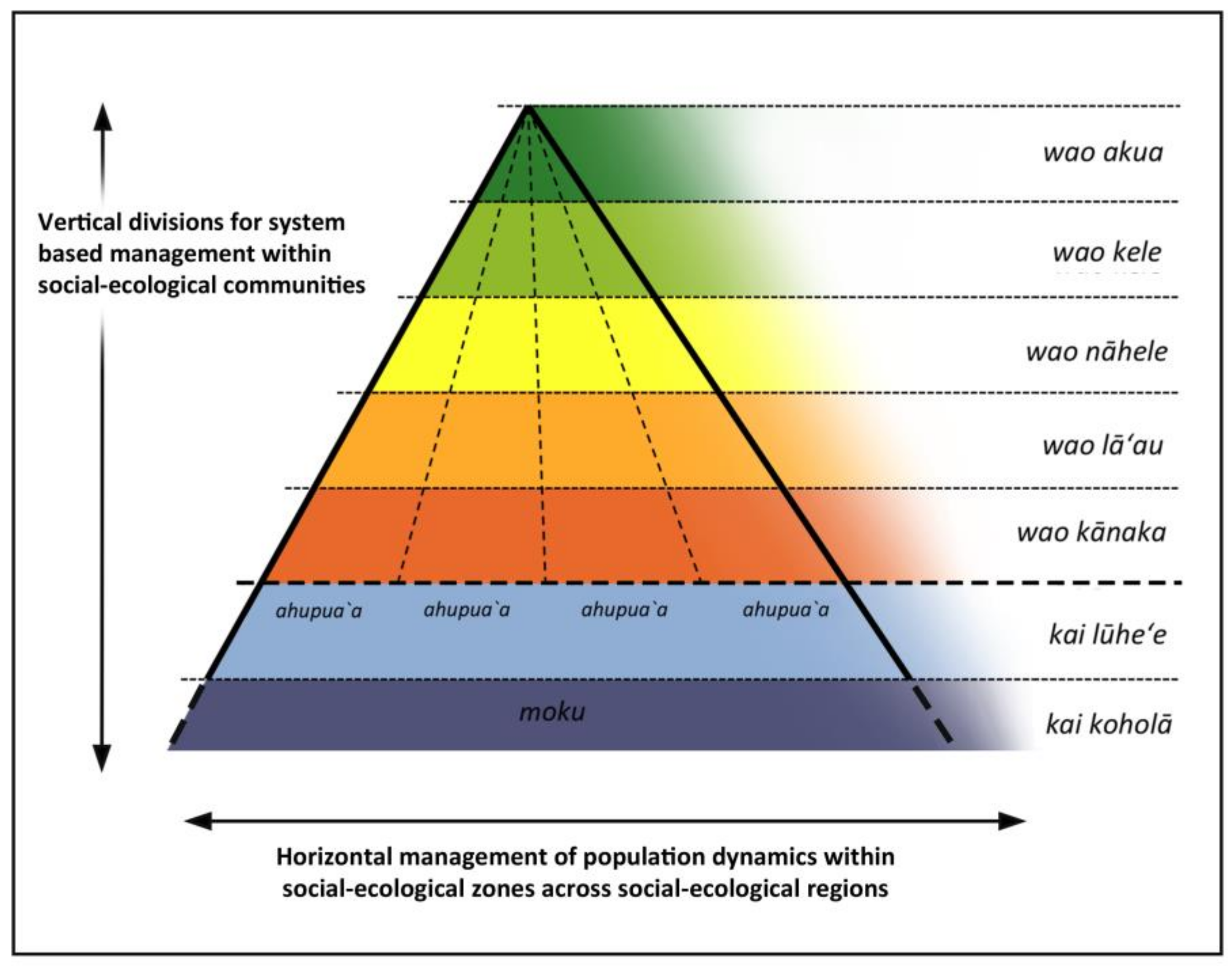
| Land Division Term | Unit within the System |
|---|---|
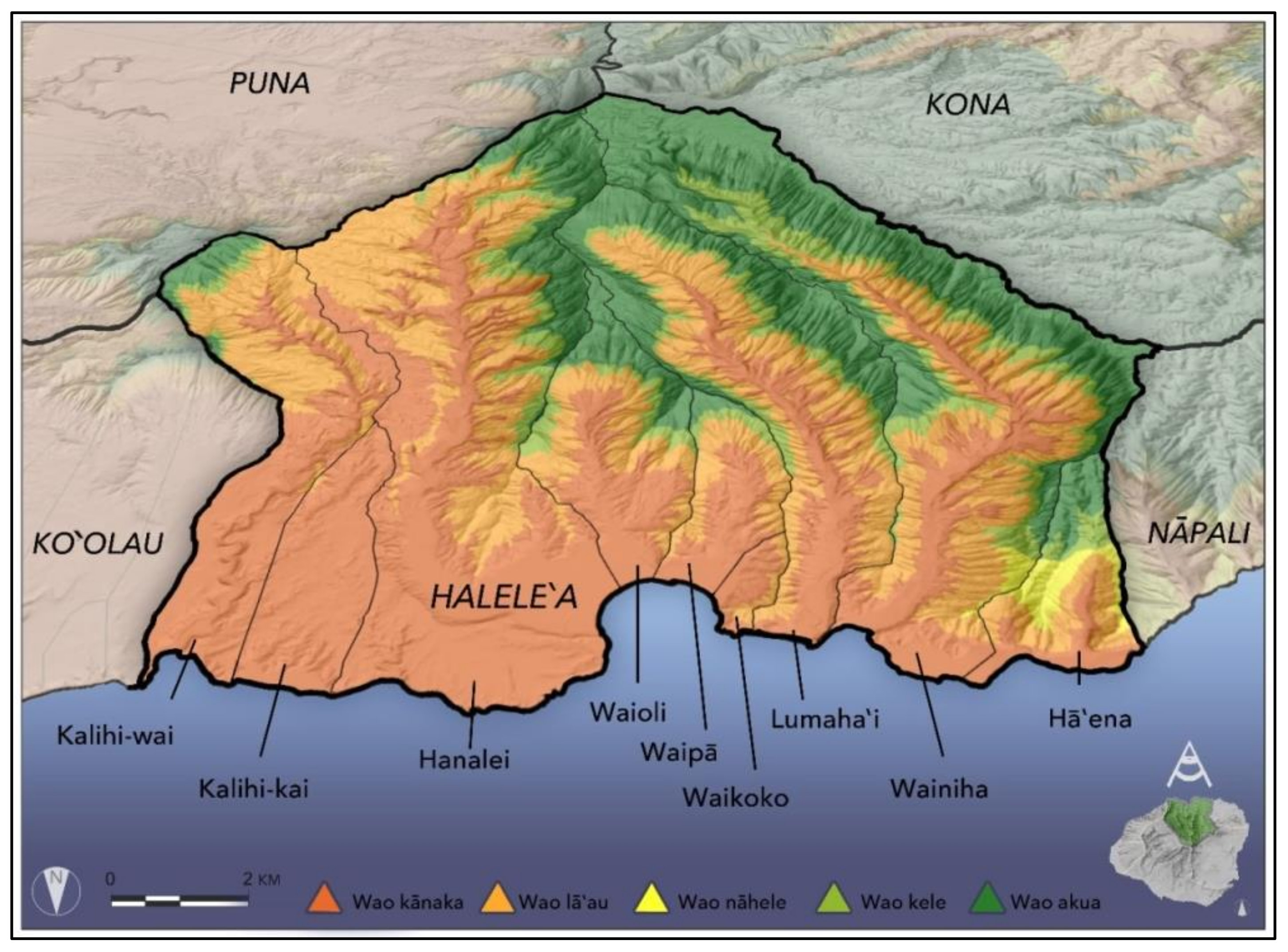
| moku | A social-ecological region |
| ʻokana/kalana | Intermediate category being either a group of ahupuaʻa within a moku that collectively compose a larger watershed; or a smaller watershed within a single, large ahupuaʻa |
| ahupuaʻa | A social-ecological community |
| ʻili | A division within an ahupuaʻa, often associated with an extended family |
| moʻo | A section of land within an ʻili |
| pauku | A strip of land within an moʻo |
| kīhāpai and others | Various types of cultivated plots |
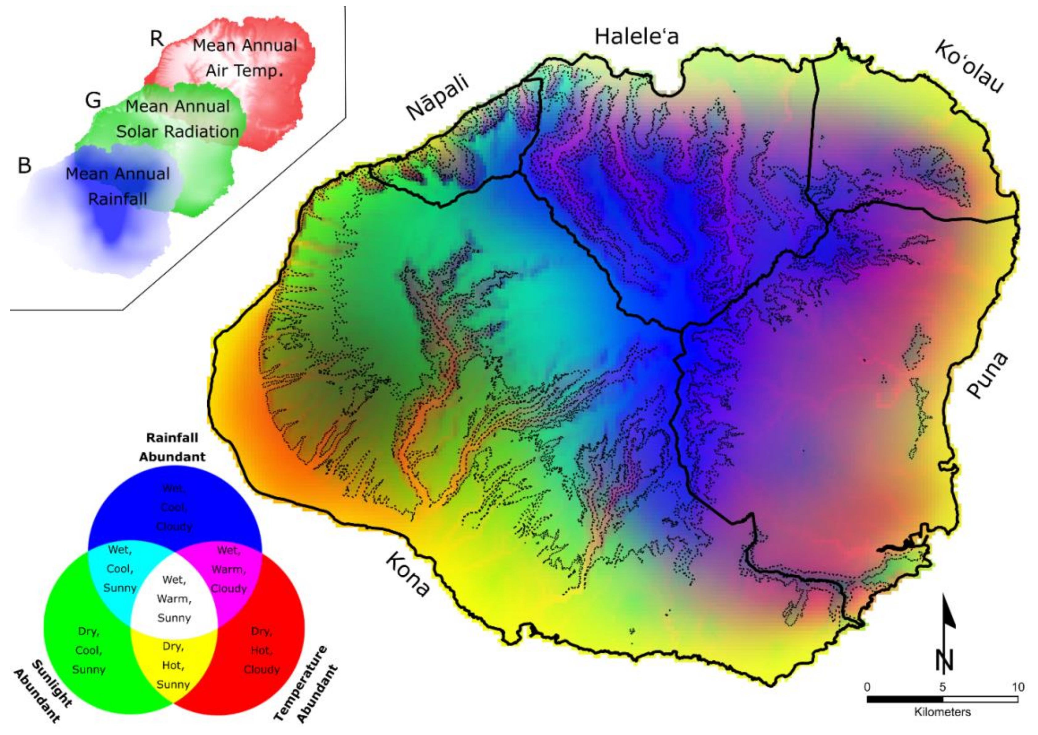
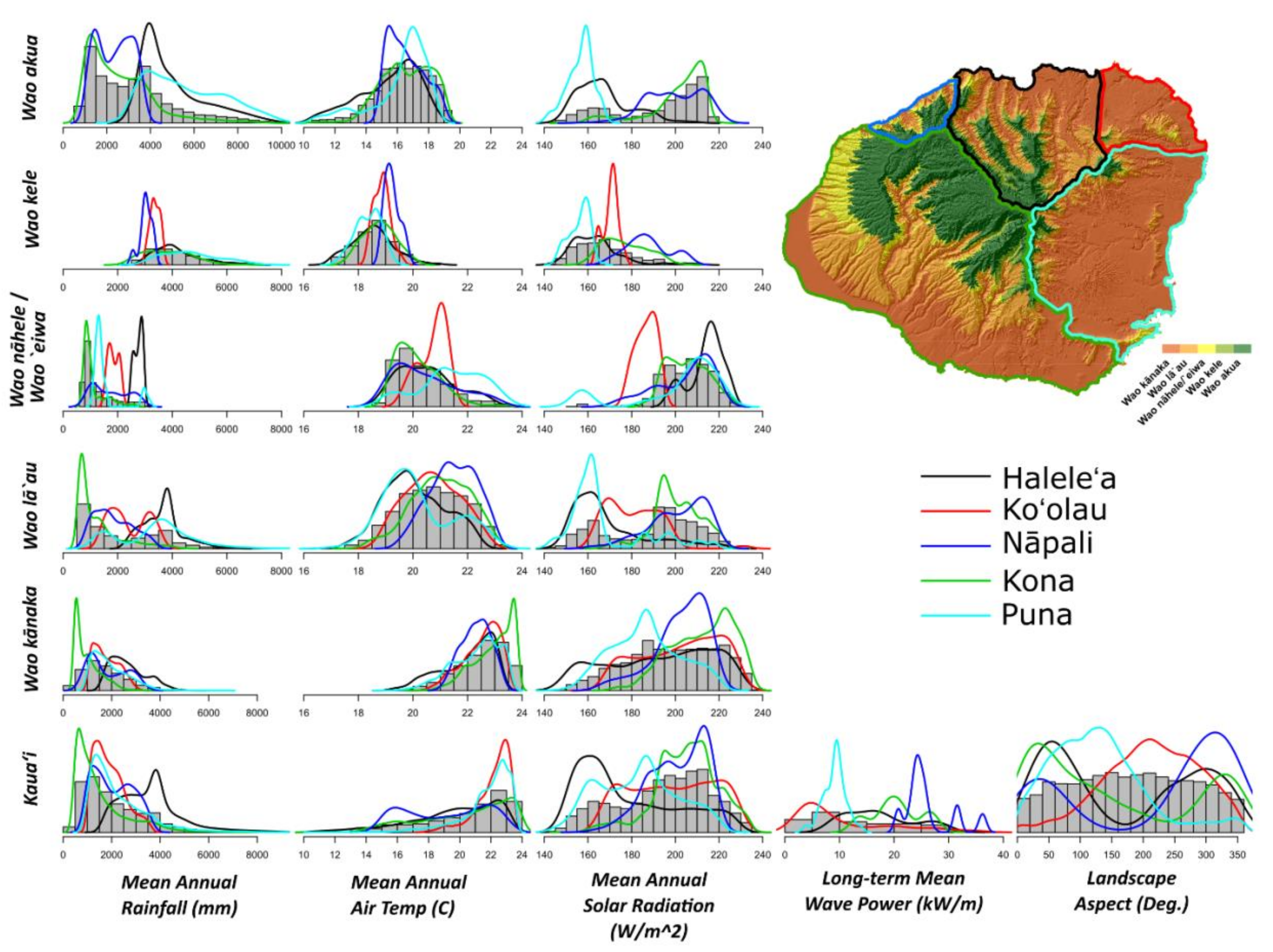
| Social-Ecological Zone | Translation | Management Implications |
|---|---|---|
| wao akua | Sacred forest | Primary function: Perpetual source population for endemic biodiversity.
Designated as “sacred forest”, making it a restricted forest zone for a native-only plant community, accessed only under strict protocols. Associated with montane cloud forest, elfin forest. |
| wao kele | Wet forest | Primary function: Maximize aquifer recharge.
An untended forest zone associated with core watershed areas (remote upland, wet forest below the clouds) which was left as a native-dominant plant community. Impractical for access except for transit-through via trails. |
| wao nāhele | Remote Forest | Primary function: Maximize habitat for native birds.
A forest zone that was minimally-tended (generally remote upland, mesic forest) and left as a native-dominant plant community. Impractical for access except by bird catchers and feather gatherers. |
| wao lāʻau | Agro-forest | Primary function: Maximize the availability of timber and non-timber forest products. A zone allowing for the management of a highly-tended forest via an integrated agroforestry (native and introduced plants) regime:
|
| wao kānaka | Habitation zone | Primary function: landscape-scale augmentation to maximize the availability of food, medicine, and housing.
A zone allowing for (but not mandating) the conversion of forest to field agriculture, aquaculture, habitation, recreation, and/or temple worship. Native and introduced trees tended, individually or in groves, for regular and specific cultural services. |
| Marine Social-Ecological Zone | Translation by Authors |
|---|---|
| ka poʻina nalu | Fringing reef with breaking waves (representing the seaward boundary of ahupuaʻa) |
| kai lūheʻe | Sea for fishing with octopus lures (outer reefs) |
| kai koholā | Sea frequented by humpback whales (Megaptera novaeangliae) (submerged volcanic shelves) |
| kai ʻele | Black sea (deep-sea area, possibly between volcanic shelves) |
| kai uli | Dark sea (deep-sea area, possibly beyond the islands’ volcanic foundations) |
| kai pualena | Sea along the horizon that gets the first touch of the sun’s light (deep-sea area) |
| kai pōpolohua-a-Kāne-i-kahiki | Distant, dark sea associated with the travels of Kāne (deep-sea area beyond sight of land) |
| Life Form | Edible Species | Source |
|---|---|---|
| Freshwater vertebrates | 5 | Maly and Maly 2003 [27] |
| Freshwater invertebrates | 4 | Maly and Maly 2003 [27] |
| Ocean vertebrates | 231 | Maly and Maly 2003 [27] |
| Ocean invertebrates | 57 | Maly and Maly 2003 [27] |
| Macro-algae | 29 | Abbott 1996 [55] |
| Birds | 38 | Keauokalani 1859–1860 [56] |
| Kapu Type | Description of kapu | Examples |
|---|---|---|
| Seasonal harvest restriction associated with spawning periods | Placed an annual ban on the harvest of key fish species during their spawning season, which helped to ensure healthy populations for future fishing seasons. | Annual six-month kapu on ʻŌpelu (Decapterus spp.) |
| Monthly harvest restriction associated with particular moon phases | Regulated either specific harvest practices or harvest of particular species on named moon phases, which effectively staggered harvesting pressure throughout the month and protected spawning events occurring on certain moons. | No fishing allowed on the 27th phase of the moon (Kāne). |
| Occasional access restriction, associated with particular areas | Intermittently imposed to restrict human access into areas that needed immediate recovery, or in areas being saved for a planned large harvest in the foreseeable future. | Lāwaʻi (an ahupuaʻa in Kona, Kauaʻi) is a place-name commemorating the lifting of a kapu over the entire bay fronting that ahupuaʻa. |
| Occasional harvest restriction, associated with a particular taxa | Intermittently imposed to temporarily rest harvest of specific taxa observed to be in decline as a means to facilitate population recovery. | Kapu placed on ʻUla (lobster, Panulirus marginatus) when population observed to be in decline. |
| Occasional harvest restriction, associated with a particular life-stage of a specific taxa | Prevented harvest of particular species at key stages in their life cycles, as a means to manage population demographics of that species and enhance reproduction. These restrictions only protected certain life stages while other life stages of that same species could be harvested. | Kapu placed on Moi liʻi (juvenile threadfin, Polydactylus sexfilis) only, while allowing for the harvest of other life stages of the same species. |
| Component of Decision Matrix | Component Description and Contextual Interpretation |
|---|---|
| moana-nui-ākea | The sea from the shoreline to the horizon, as seen from the highest vantage point in the area; and all associated biota. |
| kahakaipepeiao | The area extending from the place where the ocean meets the land to the place where soil exists. This includes the splash zone where algae, crabs, and other shellfish may be located; sands where turtles nest; dunes where seabirds nest and coastal strand vegetation exists; sea cliffs; and all associated biota. |
| mauka | The area from where soil begins, extending all the way to the mountaintops; and all associated biota. |
| nāmuliwai | All the sources of fresh water—artesian springs, streams (including coastal springs that create brackish-water and contribute to healthy and productive estuarine environments); and all associated biota. |
| kalewalani | The realm inclusive of everything above the land—the air, winds, sky, clouds, rain, rainbows, birds, atmosphere, sun, moon, planets, and stars. This encompasses all the elements and celestial bodies that influence the tides and ocean currents, which directed traditional navigation and guided fishing and planting seasons. |
| kānakahōnua | The needs of the people. This included the kānāwai (laws) that governed behaviors and ensured a functioning society which contributed to the people’s health and well-being. |
| papahelōlona | The intellect and cumulative knowledge built up over generations. This is the knowledge of kahuna (keepers of priestly knowledge), knowledge about the connections across the social-ecological system and the correlations between the cycles of nature, and knowledge of expert practitioners in astronomy, healing, and other schools of knowledge. |
| keʻihiʻihi | The spiritual realm and the ceremonies needed to maintain pono (balance) in the ʻāina. These included elements of nature, ancestral deities, and religious protocols needed to maintain sanctity in the landscape. |
© 2018 by the authors. Licensee MDPI, Basel, Switzerland. This article is an open access article distributed under the terms and conditions of the Creative Commons Attribution (CC BY) license (http://creativecommons.org/licenses/by/4.0/).
Share and Cite
Winter, K.B.; Beamer, K.; Vaughan, M.B.; Friedlander, A.M.; Kido, M.H.; Whitehead, A.N.; Akutagawa, M.K.H.; Kurashima, N.; Lucas, M.P.; Nyberg, B. The Moku System: Managing Biocultural Resources for Abundance within Social-Ecological Regions in Hawaiʻi. Sustainability 2018, 10, 3554. https://doi.org/10.3390/su10103554
Winter KB, Beamer K, Vaughan MB, Friedlander AM, Kido MH, Whitehead AN, Akutagawa MKH, Kurashima N, Lucas MP, Nyberg B. The Moku System: Managing Biocultural Resources for Abundance within Social-Ecological Regions in Hawaiʻi. Sustainability. 2018; 10(10):3554. https://doi.org/10.3390/su10103554
Chicago/Turabian StyleWinter, Kawika B., Kamanamaikalani Beamer, Mehana Blaich Vaughan, Alan M. Friedlander, Mike H. Kido, A. Nāmaka Whitehead, Malia K.H. Akutagawa, Natalie Kurashima, Matthew Paul Lucas, and Ben Nyberg. 2018. "The Moku System: Managing Biocultural Resources for Abundance within Social-Ecological Regions in Hawaiʻi" Sustainability 10, no. 10: 3554. https://doi.org/10.3390/su10103554
APA StyleWinter, K. B., Beamer, K., Vaughan, M. B., Friedlander, A. M., Kido, M. H., Whitehead, A. N., Akutagawa, M. K. H., Kurashima, N., Lucas, M. P., & Nyberg, B. (2018). The Moku System: Managing Biocultural Resources for Abundance within Social-Ecological Regions in Hawaiʻi. Sustainability, 10(10), 3554. https://doi.org/10.3390/su10103554