Article

The Importance of the Araguaia Basin in Maintaining Forest Structure, Physiognomic Patterns, and Edaphic Heterogeneity


by
Carlos de Melo e Silva-Neto
1,2,3,*,
Indiara Nunes Mesquita
4,5,
Maira Martins Freitas
2,
Rafael Barbosa Pinto
6,
Lorena Lana Camelo Antunes
7,
Danielle Oliveira Diniz
5,
Márcio Júnior Pereira
3,
Ednaldo Cândido Rocha
2,
Francine Neves Calil
8 and
Mariana Pires de Campos Telles
4,9
1
Polo de Inovação, Instituto Federal de Goiás, Goiânia 74594-111, GO, Brazil
2
Programa de Pós-Graduação em Produção Vegetal, Universidade Estadual de Goiás, Ipameri 75780-000, GO, Brazil
3
Programa de Pós-Graduação em Recursos Naturais do Cerrado, Universidade Estadual de Goiás, Campus de Ciências Exatas e Tecnológicas, Anápolis 75132-400, GO, Brazil
4
Laboratório de Genética e Biodiversidade, Universidade Federal de Goiás, Goiânia 74690-900, GO, Brazil
5
Herbário UFG, Universidade Federal de Goiás, Goiânia 74690-900, GO, Brazil
6
Laboratório de Botânica, Instituto Acadêmico de Ciências da Saúde e Biológicas, Programa de Pós Graduação em Gestão e Regulação de Recursos Hídricos (ProfÁgua), Universidade Estadual de Goiás, Iporá 76200-000, GO, Brazil
7
Centro de Ciências Integradas, Universidade Federal do Norte de Tocantins, Campus Araguaína, Araguaína 77824-838, TO, Brazil
8
Escola de Agronomia, Universidade Federal de Goiás, Goiânia 74690-900, GO, Brazil
9
Escola de Ciências Médicas e da Vida, Pontifícia Universidade Católica de Goiás, Goiânia 74605-050, GO, Brazil
*
Author to whom correspondence should be addressed.
Forests 2026, 17(9), 1121; https://doi.org/10.3390/f17091121 (registering DOI)
Submission received: 23 August 2026 / Revised: 15 September 2026 / Accepted: 17 September 2026 / Published: 20 September 2026
(This article belongs to the Section Forest Biodiversity)

Abstract

Riparian vegetation in the Araguaia basin remains poorly studied, with few forest inventories addressing its structure and composition. This study sought to integrate attributes of tree communities along the upper, middle, and lower reaches of the basin, evaluating their physiognomic organization and their relationships with edaphic characteristics, aiming to verify the differences between these three regions of the Araguaia River basin. We hypothesize (1) that the structuring and composition of the riparian vegetation community of the different regions of the Araguaia are influenced by different vegetation domains (biomes) and, consequently, the longitudinal gradient of the basin. As a secondary hypothesis (2), we also point out that forest attributes are influenced by edaphic attributes, with the patterns presented by the vegetation being affected by soil characteristics such as fertility and soil physics. We conducted inventories in 27 sites, measuring forest structure, composition, and soil properties. To compare vegetation parameters across locations and with soil characteristics, various analyses were performed, including CCA, PCA, the ANOSIM test, and GLM followed by Tukey’s test. A total of 405 individuals were recorded, belonging to 48 families and 152 species. Fabaceae was the most abundant family, followed by Rubiaceae, Simaroubaceae, and Anacardiaceae. Genera such as Aspidosperma, Andira, and Casearia were particularly diverse. Soil pH and potassium were the main edaphic factors that differentiate vegetation, being evident between gallery forests and cerradão formations. Cerradão areas generally exhibited lower diversity and more acidic soils, while gallery forests showed higher fertility and species richness. Regarding forest composition, the variables that showed significance in the CCA were Ca, Al, and clay. The species were associated with three main edaphic groups. We can highlight species from forest formations associated with soil clay content (Copaifera langsdorffii, Ixora gardneriana, Aspidosperma discolor, Siparuna guianensis, Virola sebifera); a second group consists of riparian forest species associated with aluminum levels (such as Myrsine guianensis, Mabea sp., Alchornea castaneifolia, Vochysia pyramidalis). The third group did not correspond to a specific vegetation formation but comprised species associated with calcium levels, species known not to be associated with water (Matayba guianensis, Handroanthus heptaphyllus, Luehea sp., Anadenanthera colubrina, Piptadenia gonoacantha, Guarea guidonia, Senegalia polyphylla, Curatella americana, Guazuma ulmifolia, Astronium urundeuva, and Rhamnidium elaeocarpum). The ecological heterogeneity of riparian vegetation in the Araguaia basin emphasizes the importance of soil attributes in shaping forest communities, providing baseline information for conservation strategies, reinforcing the need to consider both ecological and edaphic factors in management plans for riparian ecosystems in the Cerrado and Amazon transition zones.

1. Introduction

The Araguaia River basin encompasses one of the most significant floodplains in Brazil, with its geographic distribution entirely within national territory [1]. These floodplain areas connect aquatic and terrestrial ecosystems, sustained by the energy flows, matter, and organisms that move between them. Despite their ecological relevance, floodplains are among the most threatened systems worldwide [2]. In the Brazilian context, the Araguaia floodplain has been particularly impacted by the intensification of agricultural activities [2,3].
Moreover, the Araguaia River basin reflects the major biodiversity knowledge shortfalls highlighted in the scientific literature [4,5], which hinder the formulation and implementation of effective conservation strategies in the region. Beyond ecological aspects, this basin is also fundamental to the economy through food provision and tourism associated with recreation and fishing [6]. Among these, one aspect still scarcely explored in ecological studies concerns the relationships between vegetation structure, biomass, and forest community composition, whose understanding is essential for the management and monitoring of ecosystems at large spatial scales [7,8,9]. Vegetation structure is directly linked to a set of ecosystem services fundamental to the maintenance of natural systems, including habitat quality, erosion control, and regulation of soil sedimentation [10].
In this context, vegetation structure is related to several environmental variables, such as edaphic attributes and litter accumulation, which influence changes in floristic composition among different Cerrado vegetation formations [11]. Ecological studies allow the evaluation of these structural characteristics and their association with the implications of anthropogenic processes, integrating environmental factors such as land-use changes, landscape transformations, and socio-environmental aspects [12].
The size of the Araguaia River basin in Brazilian territory and its dimensions raise questions about the influences that shape its vegetation [13,14]. Considering that its origin in the Upper Araguaia region is close to the Pantanal region (Pantanal biome), most of its headwaters along its course, in the Middle Araguaia, are predominantly in the Cerrado biome region, and its Lower Araguaia region, leading to the mouth of the Tocantins River, is an ecotone region associated with the Amazon biome. Given that the different regions of the Araguaia basin correspond to a longitudinal gradient, differences in vegetation structure along this gradient are also to be expected. On the other hand, at a local scale, the watercourse exhibits edaphic variation strongly influenced by flood dynamics and soil types, factors that can affect species presence and forest vegetation structure [15]. Thus, in this work we investigated the relationship between region and biome of influence on riparian vegetation, hypothesizing (1) that the structuring and composition of the riparian vegetation community of the different regions of the Araguaia will present different patterns among themselves, since they are influenced by different vegetation domains (biome) and consequently the longitudinal gradient of the basin. As a secondary hypothesis (2), we also point out that forest attributes are influenced by edaphic attributes, with the patterns presented by the vegetation being affected by soil characteristics. The composition and structure of forest species are expected to vary in relation to the soil’s physical properties and fertility, for instance, sandy soils tend to retain less moisture during dry spells, whereas clayey soils tend to maintain higher moisture levels and retain more fertility-related mineral elements, such as organic matter and phosphorus. All these variations influence vegetation composition and structure, yet these patterns remain poorly understood regarding the riparian vegetation of the Araguaia basin. These characteristics are defined by the fluvial dynamics of the basin, also influencing the vegetation patterns among the phytophysiognomies.
Through the forest inventory carried out in vegetation remnants along the Araguaia River basin, we sought to elucidate two main objectives listed in accordance with the hypotheses above: (1) To understand the structure and composition of tree communities, evaluating how different physiognomies are organized and interrelated in the upper, middle, and lower Araguaia regions and their influencing biomes; (2) to analyze the relationship between forest structure and community attributes and edaphic characteristics, considering aspects such as soil fertility and physical properties.

2. Materials and Methods

2.1. Study Area

The Araguaia River constitutes the main watercourse of the Araguaia–Tocantins basin, with a total area of approximately 383,999 km2, distributed across four Brazilian states: Goiás (24.2%), Mato Grosso (35.2%), Pará (13.2%), and Tocantins (27.3%) [15]. The basin is predominantly inserted in the Cerrado biome, covering about 297,625.3 km2 (77% of the total area). The first headwaters of the Araguaia River are in regions close to the watershed that will form the Pantanal wetlands, while its northern portion lies within the Amazon biome, encompassing 87,418 km2 (23%) [16,17].
With a length of 2110 km to its confluence with the Tocantins River, the Araguaia can be divided into three main sections: upper, middle, and lower. The upper Araguaia extends from its headwaters in the municipality of Mineiros (Goiás) to the town of Registro do Araguaia (Goiás), draining an area of 36,400 km2. The middle Araguaia covers more than 300,000 km2, with 1160 km of extension between Registro do Araguaia (Goiás) and Conceição do Araguaia (Pará). The lower Araguaia begins after Conceição do Araguaia (Pará) and runs approximately 500 km until its confluence with the Tocantins River [18].
The drainage area of the Araguaia River basin covers approximately 386,765 km2, encompassing 145 municipal seats and an estimated population of 1.56 million inhabitants, of whom about 75% live in urban areas [18,19]. The basin plays a strategic role as an ecological corridor, connecting different ecosystems and species populations from the Pantanal to the Amazon [17].

2.2. Forest Inventory

Sampling consisted of 27 plots distributed along the three sections of the Araguaia River (upper, middle, and lower). The selection of sampling points was carried out through randomization, considering the network of streams within the basin and applying the inclusion criterion of the main forest vegetation formations (seasonal forest, gallery forest, and cerradão) [20]. The locations were randomly selected from among all watercourses draining into the Araguaia basin, with ten samples allocated to each section of the basin (lower, middle, and upper). Some locations were slightly shifted from their original coordinates due to access difficulties. Three original plots were excluded from the study due to severe environmental degradation, as no remnant vegetation remained at the sites.
The installed plots measured 10 m × 10 m (100 m2) [21], with their respective geographic coordinates recorded. For standardization throughout the text, seasonal forest formations were referred to as FE, gallery forest as MC, and cerradão as CE. The inclusion criteria encompassed all tree individuals with a circumference at breast height (CBH) ≥ 15.7 cm, corresponding to a diameter at breast height (DBH) ≥ 5 cm. These individuals were identified by their scientific names and measured with a measuring tape [20]. The total height of all sampled individuals was obtained with the aid of an electronic clinometer (Haglöf) when necessary [22].

2.3. Soil Characterization

Soil sampling was carried out using a metallic frame measuring 25 cm × 25 cm (0.0625 m2), randomly placed within the established plots. Soil was collected with a shovel from the surface layers (0–20 cm depth), mixed, and homogenized to compose a representative sample of approximately 500 g. The samples were air-dried, de-clodded, and sieved through a 2 mm mesh. Particle size composition was determined using the pipette method, while physical and chemical analyses followed the protocols established by Embrapa [23]. The soil variables analyzed were pH (CaCl2), phosphorus (Mehlich-1), potassium, calcium, magnesium, organic matter, aluminum, and the percentages of clay, silt, and sand; the following indices were calculated: H + Al (potential acidity), T (CEC at pH 7.0), BS (sum of exchangeable bases), and V (base saturation of the CEC at pH 7.0). pH in calcium chloride (CaCl2), as well as aluminum (Al), calcium (Ca), magnesium (Mg), and potassium (K) levels, were determined according to the methodology in [24]. Based on these results, CEC and base saturation were calculated [24]. Available phosphorus was determined using the ion-exchange resin method [25]. Organic carbon (C), used to determine organic matter (OM) content, was determined via the wet oxidation method using potassium dichromate [24].

2.4. Botanical Material

All plant material containing reproductive structures was collected for the preparation of herbarium sheets and subsequently deposited in official herbaria, including the Herbarium of the Federal University of Goiás (UFG) and the Herbarium of the State University of Goiás (HUEG), with duplicates occasionally sent to other national herbaria. Collections carried out in National Parks or Federal Conservation Units were authorized by the Biodiversity Authorization and Information System—SISBIO (License No. 92303-1; Brazilian federal environmental license). For the Pedra Azul State Park—MT, collection authorization was granted by the State Secretariat for the Environment of Mato Grosso (SEMA-MT).
In areas sampled outside conservation units, the collection of botanical material was preceded by the issuance of the voluntary registration for the collection of botanical, fungal, and microbiological material from SISBIO (No. 24365-1). Each specimen collected had its geographic coordinates recorded, accompanied by a description of the general aspects of the plant and its surroundings. Taxonomic identification of specimens was conducted with the support of specialists in different taxonomic groups and through consultation of specific bibliographies, such as the Flora e Funga do Brasil [26].

2.5. Data Analysis

Forest structure characteristics were evaluated descriptively, considering diameter and height distribution, as well as biomass calculation, with comparisons made among different vegetation physiognomies and basin regions. The tree community was characterized through ecological attributes such as abundance, species richness, and diversity, as well as phytosociological variables: absolute density (AD, n/ha), relative density (RD, %), absolute frequency (AF, %), relative frequency (RF, %), absolute dominance (DoA, m2/ha), relative dominance (DoR, %) and importance value index (IVI, %). In addition, ecological indices were calculated: species richness (S), number of individuals (Ind), Simpson’s dominance (Simp), Shannon–Weaver diversity (SW) and Menhinick diversity (Menh), and Evenness (J).
Edaphic attributes related to soil fertility and physical properties (Ca, Mg, Al, H + Al, CEC, P, K, organic matter, Al saturation, base saturation, clay, silt, and sand), together with structural variables (height—H, diameter at breast height—DBH, basal area, volume using the formula: V = 0.0673 × (ρ × (DBH2) × H)0.976, biomass—obtained by multiplying volume by average wood density, and carbon—estimated as 60% of biomass), were analyzed as averages per hectare. The methodologies for estimating volume, biomass, and density were adapted from Chave et al. [27], and carbon estimation followed IPCC recommendations [28,29]. Comparisons among vegetation types and basin regions were performed using statistical tests.
To relate forest structure and community characteristics with soil attributes, multivariate analyses were applied, this included a principal component analysis (PCA) to select soil attributes related to the vegetation; subsequently, we used canonical correspondence analysis (CCA) to relate the selected soil attributes to vegetation types and tree species occurrence. All soil attribute variables were used to construct a PCA; however, some were selected based on their greater technical relevance to the soil, while others were excluded from the analysis due to their relationship with those selected variables. Specifically, we retained Al (over H + Al), clay and sand (among soil texture attributes), Ca (over Mg), and BS% (over pH and M%). Other soil variables, such as CEC, P, K, and OM, were retained in the analysis for the CCA. To refine the CCA plot, only species showing a correlation with the axes greater than 10% were selected, as indicated by refs. [30,31]. The tree community was also compared among physiognomies and basin regions using the ANOSIM test (similarity analysis).
All variables related to forest community and structure, as well as edaphic data, were interrelated and compared across vegetation physiognomies and basin locations (upper, middle, and lower Araguaia). We employed a general linear model (GLM) using soil attributes, structural variables from the forest inventory, and ecological indices as dependent variables. Watershed location, vegetation physiognomy type, and the interaction between these two variables were used as categorical variables. An initial analysis was conducted at a 95% significance level; subsequently, Tukey’s mean comparison test—also at the same level of statistical significance—was performed to examine differences between watershed and vegetation type categories. For vegetation types and locations with only a single sample, the values were excluded from statistical comparison, with only the absolute value retained in the table. These cases are marked with an asterisk on the table.
All values were assessed for their distribution to identify those conforming to a normal distribution, and all variables exhibited this distribution. Although data transformations, such as Box–Cox and log transformations, were evaluated to check for improvements in the significance of relationships within the analyses, no significant improvements were observed; therefore, we opted to retain the original data. To investigate relationships among ecological, structural, and edaphic variables, Spearman’s correlation was applied. Results were presented as means, total values, and stratified by physiognomy and basin location. All data produced are organized in a summary spreadsheet, available in Supplementary Table S1. The herbarium accession numbers of botanical species recorded in the forest inventory were available in Supplementary Table S2.

3. Results

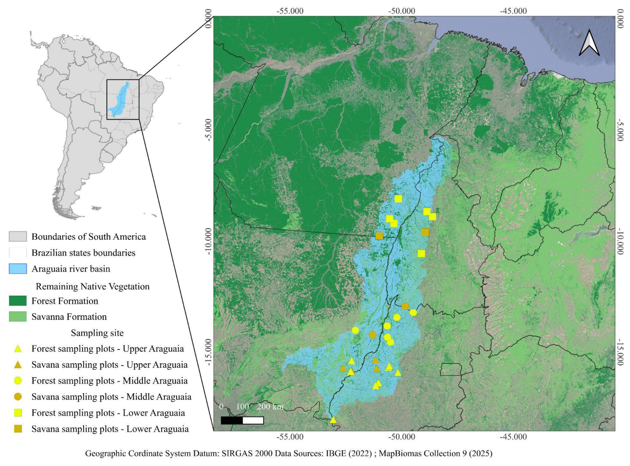
Across the 27 plots (Figure 1), a total of 405 individuals were inventoried, corresponding to 48 families and 152 tree species. Fabaceae was the botanical family with the highest number of individuals (52), followed by Rubiaceae (32), Simaroubaceae (28), Anacardiaceae (25), Annonaceae (22), Vochysiaceae (17), Sapindaceae (15), Arecaceae (14), and Apocynaceae and Myrtaceae (13 each).
Regarding the most abundant genera, Aspidosperma Mart. & Zucc. presented four species, followed by Andira Lam., Casearia Jacq., Diospyros L., Hirtella L., Terminalia L., and Handroanthus Mattos with three species each, and Astronium Jacq., Attalea Kunth, and Bauhinia L. with two species each.
The variables that showed differences among river basin regions, vegetation physiognomies, or in the interaction between these two factors are presented in Table 1, along with their respective statistical significance values. Variables that did not show significant differences were not included in the table.
For edaphic attributes (Table 2), differences were found among vegetation from different localities of the basin or among physiognomies for pH (Basin × Physiognomy), with the lowest values recorded for CE vegetation (~3.70), while for the other physiognomies, values ranged between 4 and 5.7. For K values (Basin, Basin × Physiognomy), the highest concentrations were found in the upper Araguaia, with approximately 107.00 mg/dm3, differing only from the middle Araguaia with 54.67 mg/dm3. Among physiognomies within the basin, CE vegetation in the upper Araguaia presented the lowest K values (38.00 mg/dm3).
Regarding ecological attributes such as species richness (Taxa S), Shannon–Weaver diversity, and Menhinick diversity, the values showed a similar pattern across vegetation types. Lower values were found for CE vegetation in the upper Araguaia and in other localities of the basin, as well as when compared with other physiognomies in any locality of the basin. These values are presented in Table 3. For structural attributes (Table 3), no differences were found among vegetation patterns or across basin regions.
Regarding ecological and structural attributes in relation to edaphic variables, the results demonstrated a positive relationship between soil K content and the Shannon–Weaver diversity index (coef: 0.39) as well as the Menhinick diversity index (coef: 0.41). A negative relationship was observed between the number of trees and soil sand percentage (coef: –0.41), and also for tree height (–0.42). Similarity variables among localities and vegetation physiognomies did not present valid significant differences to be highlighted in the results (ANOSIM). Community and similarity analyses did not reveal structuring among different localities of the Araguaia basin or among vegetation physiognomies (Table 4).
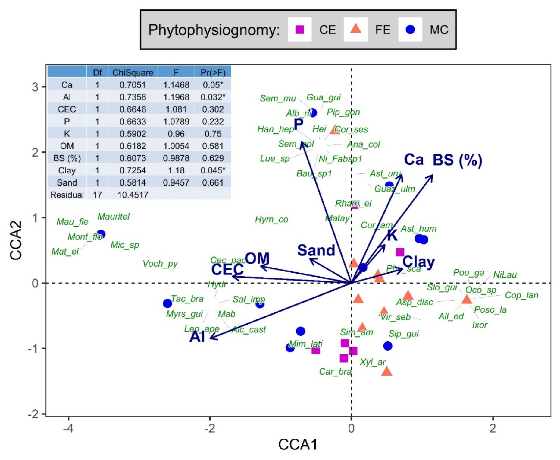
The variables that showed significance in the CCA were Ca (p = 0.05), Al (p = 0.032), and Clay (p = 0.045). The species were associated with three main edaphic groups. The first group, associated with clay content, comprises forest species from both forest formations and the Cerrado, such as Copaifera langsdorffii, Ixora gardneriana, Aspidosperma discolor, Siparuna guianensis, and Virola sebifera. The second group, associated with aluminum levels and dominated by riparian forest species, includes Myrsine guianensis, Mabea sp., Alchornea castaneifolia, and Vochysia pyramidalis (0.610), with the latter showing the strongest association with the CCA axes. The relationships of all species with the CCA axes are presented in the Supplementary Table S3.
The final group consists of species associated with the element Ca (which showed a significant relationship); these species originate from various vegetation types, such as Matayba guianensis, Handroanthus heptaphyllus, Luehea sp., Anadenanthera colubrina, Piptadenia gonoacantha, Guarea guidonia, Senegalia polyphylla, Curatella americana, Guazuma ulmifolia, Astronium urundeuva, and Rhamnidium elaeocarpum. Other relationships can be seen in Figure 2.
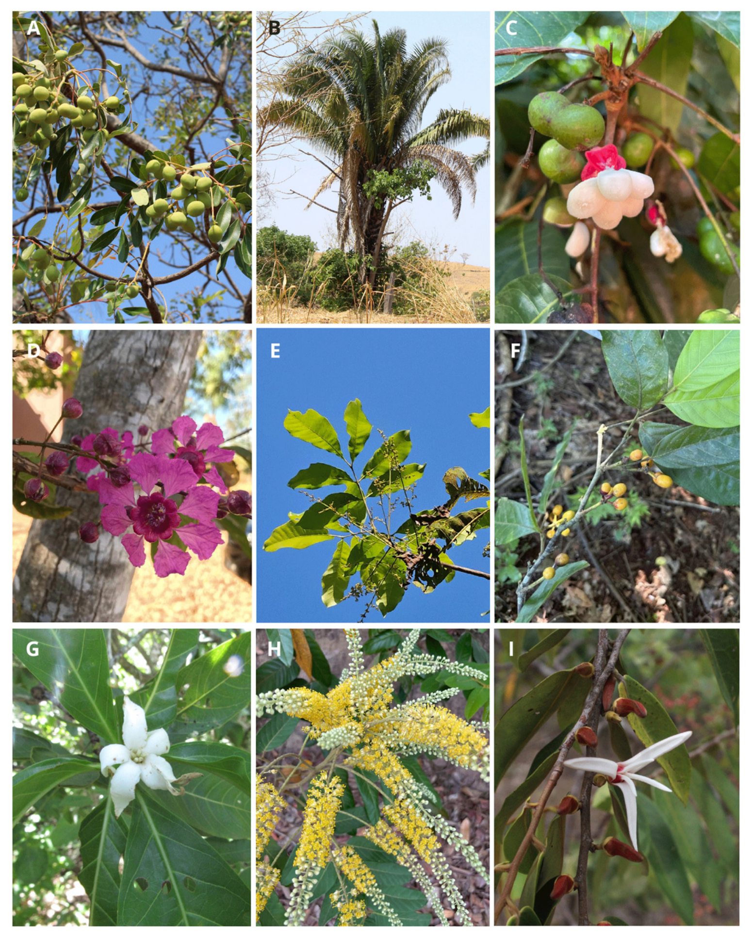
In vegetation associated with streams of the Araguaia basin, the ten species with the highest IVI were Simarouba amara Aubl., Attalea speciosa Mart., Protium heptaphyllum (Aubl.) Marchand, Physocalymma scaberrimum Pohl, Tapirira guianensis Aubl., Unonopsis guatterioides (A.DC.) R.E.Fr., Alibertia edulis (Rich.) A.Rich., Tachigali vulgaris L.G.Silva & H.C.Lima, Xylopia aromatica (Lam.) Mart., and Curatella americana L. Nine of these species are shown in Figure 3.
Minor differences in species composition among basin localities were related to the occurrence of a few species (Erisma uncinatum Warm., Jacaranda copaia (Aubl.) D.Don, Senegalia loretensis (J.F.Macbr.) Seigler & Ebinger, and Cecropia sciadophylla Mart.), which are considered Amazonian.

4. Discussion

The results of the forest inventory in the Araguaia basin highlighted the structural and floristic complexity of riparian vegetation remnants associated with streams of the Araguaia River basin. Drainage regions such as the Araguaia basin present particularities regarding Cerrado biodiversity due to their strong contact with other biomes, such as the Amazon [32].
The high richness of tree species (152 species distributed across 48 families), even in environments strongly conditioned by hydrological regimes and sandy soils, indicates high environmental heterogeneity, reinforcing the ecological importance of the Araguaia River basin. Moreover, the recorded richness is consistent with values observed in tropical riparian forests and reinforces the role of these formations as important biodiversity reservoirs in environmentally complex landscapes [33].
The floristic composition of Araguaia vegetation shows differences along the basin, with the lower Araguaia portion being strongly influenced by Amazonian vegetation, including the presence of forest species typical of this biome (Erisma uncinatum, Jacaranda copaia, and Cecropia sciodaphylla). The presence of Amazonian species restricted to the lower Araguaia highlights the transitional character and biogeographic relevance of the basin’s vegetation remnants, characterizing the region as an ecotone. Studies indicate that ecotonal areas present high taxonomic and functional diversity and play an important role in maintaining ecological processes at the regional scale, especially in the face of deforestation and climate change [34].
This floristic mosaic indicates that these vegetation remnants play a strategic role in connectivity between biomes, allowing genetic and ecological flows between the Cerrado and the Amazon [35]. Such a characteristic broadens and reinforces the relevance of the region in conservation policies, since the loss of these environments would compromise not only biodiversity at the basin scale, but could also trigger ecological processes at the regional scale within the biome transition. Ecological connectivity is fundamental for maintaining gene flow and ecological processes across large landscapes [36].
The Araguaia basin is configured as a vast floodplain, where river dynamics directly affect vegetation, both structurally and compositionally. The longer an area remains flooded throughout the year, the more specialized the species present in this vegetation become under such conditions. Although the effect of flooding on vegetation was not directly assessed in this study, it is known that Cerrado vegetation types may or may not be associated with water and, consequently, influenced by the river’s hydrological regime. For example, vereda formations and gallery forests are directly influenced by water, whereas Cerrado sentido restrito formations are not [37].
In addition to water availability, the river also leaches the soil, altering particle dynamics by carrying clay particles and maintaining a sandy profile, while depositing organic matter that modifies soil edaphic dynamics [38]. Our results corroborate with this pattern, as the soils of the studied vegetation are sandy and directly influenced by the river. Sandy soils have lower water and nutrient retention capacity, which limits vegetation structural development, especially under the influence of flood pulses [39].
Highlighting the floristic composition of the basin, the ecological indicators found in this study were consistent with those recorded for forest formations associated with water or floodplains, particularly in the Amazon (e.g., Shannon–Weaver diversity—SW of 2.29 nats/ind (natural unit of information per individuals) compared with 2.86 nats/ind reported by Dias et al. [40]). On the other hand, SW values were lower than those reported for riparian formations of the Cerrado or within the basin itself, as observed by Ferreira et al. [41], who recorded mean SW values of 3.26. Cabacinha and Fontes [42] reported SW of 3.86 nats/ind for vegetation in the Upper Araguaia. Floristic composition, tree species richness, and forest structure associated with watercourses are linked to the location of forest types along the flooding gradient [32,43,44]. Along a flooding gradient, vegetation commonly presents lower species richness, higher dominance, and lower evenness in areas closer to watercourses, since species more specialized to such conditions dominate the vegetation [45]. Among the main species inventoried in our study, the most frequent are those commonly found in forest formations associated with water, such as Simarouba amara, Protium heptaphyllum, Tapirira guianensis, Unonopsis guatterioides, and Calophyllum brasiliense.
Forest studies aim to understand the influence of edaphic characteristics on vegetation structure, since these factors condition water and nutrient availability as well as species establishment in forest ecosystems [33]. At a local scale, the physicochemical properties of the soil are among the main determinants of spatial structure in plant communities in tropical environments [46]. In the present study, edaphic attributes demonstrated that variables such as soil sand percentage and potassium (K) content can be associated with floristic composition (diversity), with positive correlations between K and the Shannon–Weaver and Menhinick indices. In our study, it was found that savanna-like formations, referred to here as CE, exhibited soils with higher acidity (lower pH) and lower potassium levels than forest formations. According to Gonçalves et al. [47], general soil fertility conditions reflecting high fertility when values are high and low fertility when values are low. The results found here corroborate studies that highlight the relationship between soil fertility levels and plant diversity in tropical ecosystems, particularly in forest environments [11,42,48].
On the other hand, the negative association between the number of trees and the percentage of sand in the soil corroborates that physical characteristics also play a role in vegetation structure, affecting parameters such as tree height and individual density. Other authors, such as Lenza et al. [49] and Gonçalves et al. [47,50], studying transitional areas between savanna and forest vegetation in the Cerrado, also verified the influence of soil fertility and texture on vegetation changes.
Gonçalves et al. [47] reported that flooded areas under the influence of hydrological regimes tend to present lower richness of forest species. Thus, the findings of this study reinforce that the hydrological dynamics of the basin affect soil characteristics and affect the vegetation, with forest formations such as gallery forests and palm swamps, which are closely associated with water, potentially differing from other vegetation types.
Among the species inventoried, Simarouba amara stood out with the highest Importance Value Index (IVI), followed by Attalea speciosa, Protium heptaphyllum, Physocalymma scaberrimum, and Tapirira guianensis. Simarouba amara has a wide geographic distribution across both Cerrado and Amazon domains and is commonly found in riparian forests [40,50], which justifies the superior phytosociological indices found in this study. Until now, the only forest inventory carried out in the region was the study by Cabacinha and Fontes [42], which evaluated vegetation fragments in the Upper Araguaia (Mineiros, GO and Alto Araguaia, MT), not necessarily associated with water. In that study, the authors recorded 109 species belonging to 78 genera and 42 families, compared with the 152 species, 158 genera, and 48 families found here. The most frequent species in their study were Bocageopsis mattogrossensis (R.E. Fr.) R.E. Fr., Tachigali vulgaris, Tapirira guianensis, and Nectandra warmingii Meisn., with only the second and third also occurring along the basin.
Regarding species groups and soil characteristics, we can highlight species from forest formations associated with soil clay content (Copaifera langsdorffii, Ixora gardneriana, Aspidosperma discolor, Siparuna guianensis, Virola sebifera); a second group consists of riparian forest species associated with aluminum levels (such as Myrsine guianensis, Mabea sp., Alchornea castaneifolia, Vochysia pyramidalis). The third group did not correspond to a specific vegetation formation but comprised species associated with calcium levels, species known not to be associated with water (Matayba guianensis, Handroanthus heptaphyllus, Luehea sp., Anadenanthera colubrina, Piptadenia gonoacantha, Guarea guidonia, Senegalia polyphylla, Curatella americana, Guazuma ulmifolia, Astronium urundeuva, and Rhamnidium elaeocarpum).
In other surveys of the Araguaia River basin, Pio et al. [51] reported Apuleia leiocarpa (Vogel) J.F. Macbr. (Fabaceae), Copaifera langsdorffii Desf. (Fabaceae), Hymenaea courbaril L. (Fabaceae), and Protium heptaphyllum (Burseraceae) as the most common species in the basin, with only P. heptaphyllum also appearing in our study. This difference is likely due to the distinct physiognomies sampled in this work, which included cerradão (Cerrado Forest), gallery forest, and seasonal forest formations.
In addition, the region has been under strong anthropogenic pressure, especially due to vegetation suppression, being one of the most deforested river basins in the country [52]. Gomes et al. [53] highlight that the practice of pasture in naturally unstable areas (soil slopes) is one of the main threats to the basin, which confirms observations made during the execution of this study, where several points of dismantling and drainage ditches were observed in wetland areas. Thus, the data gathered here on the remaining vegetation areas can be used as a tool for conservation and management of the basin. Assis et al. [54] indicates that the basin has only 9.42% of its territory protected by Conservation Units. The authors point out that these areas are poorly distributed along the basin and are not always effective in their protection.
The phytosociological survey highlights the main species found in the riparian vegetation of the Araguaia region. Identifying the most frequent species and those with the highest Importance Value Index (IVI) for the region can also contribute to decision-making regarding basin management, since species with high IVI values reflect greater adaptation to local edaphic and hydrological conditions and constitute useful parameters to guide management strategies and ecological restoration [55].
To demonstrate this relevance, we highlight the case of restoration of degraded areas. Brazil has committed to restoring 18 million hectares by 2030, with one third of these areas located in the Cerrado biome [56]. In this context, floristic studies are essential for understanding the flora inhabiting a given region, as they enable the recommendation of replanting suppressed areas with native species found locally.
The ten most important species identified in the entire community through the phytosociological survey are recommended for reforestation [57,58] and represent a group of great importance in recovery processes, as they present greater area coverage and wide distribution throughout the basin. Widely distributed and structurally dominant native species play a central role in forest restoration by modifying the microclimate, increasing nutrient availability, and facilitating the recruitment of late-successional species, thereby accelerating ecological succession [49]. With the information presented in this study, it is now possible to select the most suitable species for restoration of degraded vegetation in the basin.
Systematized forest inventories across the Araguaia basin provide insights into vegetation structure and community composition, as well as edaphic soil attributes. These data are available in the Supplementary Materials and can be accessed alongside the study. This dataset constitutes a relevant basis for integrated landscape analyses, considering the scarcity of studies that relate vegetation to other components such as fauna, hydrology, and land use.
Furthermore, the high floristic richness recorded, together with the occurrence of Amazonian species restricted to the lower Araguaia, confirms that the basin features forest species from both the Amazon Rainforest and the forest and savanna formations of the Cerrado. The Araguaia basin requires multiscale conservation strategies that integrate scientific knowledge, public policies, and community practices. Protecting these environments not only ensures the maintenance of local biodiversity but also guarantees the provision of essential resources and ecosystem services for riparian populations. The study presents an unprecedented contribution by systematizing structural, floristic, and edaphic data along the Araguaia River basin, filling a knowledge gap regarding the vegetation of this important hydrographic region, as no other forest inventory has been found for the basin. The study revealed unique vegetation patterns for the basin that are relevant for decision-making aimed at the management and conservation of natural resources.
Future studies are recommended, with emphasis on expanding knowledge of the floristic richness found in the region, particularly in wetland areas, as well as integrating these data with information on fauna and other landscape components. Such integration will enable a better understanding of the ecological processes that structure the Araguaia River basin.

5. Conclusions

The vegetation remnants along the Araguaia River basin highlight the influence of water on riparian vegetation, directly affecting forest communities. Edaphic soil aspects also influence vegetation structure.
The forest community structure and composition demonstrated that there is no longitudinal gradient along the basin (upper, middle, and lower Araguaia), refuting our first hypothesis, with differences only associated with the distinct physiognomies sampled and the occurrence of Amazonian forest species in the lower Araguaia region. In any case, we recorded high floristic richness throughout the basin, but the occurrence of Amazonian species was restricted to the lower Araguaia region.
Regarding the study’s second hypothesis, it was found that savanna-like formations, referred to here as CE, exhibited soils with higher acidity (lower pH) and lower potassium levels than forest formations. We verified the significant associations of soil sand composition and potassium levels with vegetation characteristics, thereby confirming the hypothesis, while also highlighting differences in soil attributes between savanna and forest formations. Furthermore, the forest community could be categorized into three distinct groups: a group of forest species associated with clayey soils; a group of riparian vegetation species associated with high aluminum levels; and a group of non-riparian species associated with calcium content.

Supplementary Materials

The following supporting information can be downloaded at: https://www.mdpi.com/article/10.3390/f17091121/s1, Table S1: Analytical summary of the parameters evaluated in the Araguaia River Basin, Brazil; Table S2: Herbarium accession numbers of botanical species recorded in the forest inventory; Table S3: % parameters evaluated of relation between species and axis in CCA in the Araguaia River Basin, Brazil.

Author Contributions

Conceptualization, C.d.M.e.S.-N., I.N.M., M.M.F., R.B.P., L.L.C.A., D.O.D., M.J.P., F.N.C. and M.P.d.C.T.; methodology, C.d.M.e.S.-N., I.N.M., R.B.P. and L.L.C.A.; software, C.d.M.e.S.-N., E.C.R., M.M.F. and M.J.P.; validation, C.d.M.e.S.-N., I.N.M., M.M.F., R.B.P., L.L.C.A., D.O.D., E.C.R., M.J.P., F.N.C. and M.P.d.C.T.; formal analysis, C.d.M.e.S.-N., I.N.M., R.B.P. and L.L.C.A.; investigation, C.d.M.e.S.-N., I.N.M., M.M.F., R.B.P. and L.L.C.A.; resources, M.P.d.C.T.; data curation, C.d.M.e.S.-N., E.C.R. and I.N.M.; writing—original draft preparation, C.d.M.e.S.-N., I.N.M., M.M.F., R.B.P., L.L.C.A., D.O.D., M.J.P., F.N.C. and M.P.d.C.T.; writing—review and editing, C.d.M.e.S.-N., I.N.M., M.M.F., R.B.P., L.L.C.A., D.O.D., M.J.P., F.N.C. and M.P.d.C.T.; visualization, C.d.M.e.S.-N., I.N.M., M.M.F., R.B.P., L.L.C.A., D.O.D., E.C.R., M.J.P., F.N.C. and M.P.d.C.T.; supervision, C.d.M.e.S.-N., F.N.C. and M.P.d.C.T., project administration, C.d.M.e.S.-N., F.N.C. and M.P.d.C.T.; funding acquisition, M.P.d.C.T. All authors have read and agreed to the published version of the manuscript.

Funding

The authors are grateful to the Programa Araguaia Vivo 2030 (TWRA/FAPEG)—proc. 202210267000536 and PPBio Araguaia (CNPq—Processo: 441114/2023-7) for the financial and logistic support to conduct this research. This work is a contribution of the National Institute of Science and Technology (INCT) in Ecology, Evolution, and Biodiversity Conservation funded by CNPq (grant 409197/2024-6) and FAPEG (grant 201810267000023) and PELD Araguaia (CNPq 445733/2024-1/ FAPEG 202510267001637). We thank the State University of Goiás for the financial resources provided through Call for Proposals PrP/UEG No. 01/2024 (Pró-Programas), Funding Agreement No. 7/2026—UEG (90763860), and SEI Process No. 202400020007877 (Agradecemos à Universidade Estadual de Goiás pelo “Recurso financeiro proveniente do Edital/Convocatória PrP/UEG nº 01/2024 (Pró-Programas), Termo de Fomento nº 7/2026—UEG (90763860) e Processo SEI nº 202400020007877).

Data Availability Statement

The entire data set that supports the results of this study was published in the article itself and Supplementary Materials.

Acknowledgments

We thank the state environmental agencies of Goiás and Mato Grosso for the collection permits, and ICMBio for the Sisbio authorization. The authors CMSN and MPCT would like to thank the continuation of the CNPq productivity grant.

Conflicts of Interest

The authors declare no conflicts of interest.

References

  1. Latrubesse, E.M.; Arima, E.; Ferreira, M.E.; Nogueira, S.H.; Wittmann, F.; Dias, M.S.; Dagosta, F.C.P.; Bayer, M. Fostering water resource governance and conservation in the Brazilian Cerrado biome. Conserv. Sci. Pract. 2019, 1, e77. [Google Scholar] [CrossRef] [Scilit]
  2. Pelicice, F.M.; Agostinho, A.A.; Akama, A.; Filho, J.D.A.; Azevedo-Santos, V.M.; Barbosa, M.V.M.; Bini, L.M.; Brito, M.F.G.; Candeiro, C.R.d.A.; Caramaschi, É.P.; et al. Large-scale degradation of the Tocantins–Araguaia River basin. Environ. Manag. 2021, 68, 445–452. [Google Scholar] [CrossRef] [Scilit]
  3. Coe, M.T.; Latrubesse, E.M.; Ferreira, M.E.; Amsler, M.L. The effects of deforestation and climate variability on the streamflow of the Araguaia River, Brazil. Biogeochemistry 2011, 105, 119–131. [Google Scholar] [CrossRef] [Scilit]
  4. Hortal, J.; de Bello, F.; Diniz-Filho, J.A.F.; Lewinsohn, T.M.; Lobo, J.M.; Ladle, R.J. Seven shortfalls that beset large-scale knowledge of biodiversity. Annu. Rev. Ecol. Evol. Syst. 2015, 46, 523–549. [Google Scholar] [CrossRef] [Scilit]
  5. García-Girón, J.; Bini, L.M.; Heino, J. Shortfalls in our understanding of the causes and consequences of functional and phylogenetic variation of freshwater communities across continents. Biol. Conserv. 2023, 282, 110082. [Google Scholar] [CrossRef] [Scilit]
  6. Santos, A.A.; Silva, D.R. Pesca artesanal na região do Vale do Araguaia: Desafios e perspectivas. Braz. J. Dev. 2019, 5, 33199–33212. [Google Scholar] [CrossRef] [Scilit]
  7. Avitabile, V.; Herold, M.; Heuvelink, G.B.M.; Lewis, S.L.; Phillips, O.L.; Asner, G.P.; Armston, J.; Ashton, P.S.; Banin, L.; Bayol, N.; et al. An integrated pan-tropical biomass map using multiple reference datasets. Glob. Change Biol. 2016, 22, 1406–1420. [Google Scholar] [CrossRef] [Scilit]
  8. Baccini, A.; Goetz, S.J.; Walker, W.S.; Laporte, N.T.; Sun, M.; Sulla-Menashe, D.; Hackler, J.; Beck, P.S.A.; Dubayah, R.; Friedl, M.A.; et al. Estimated carbon dioxide emissions from tropical deforestation improved by carbon-density maps. Nat. Clim. Change 2012, 2, 182–185. [Google Scholar] [CrossRef] [Scilit]
  9. Saatchi, S.S.; Harris, N.L.; Brown, S.; Lefsky, M.; Mitchard, E.T.A.; Salas, W.; Zutta, B.R.; Buermann, W.; Lewis, S.L.; Hagen, S.; et al. Benchmark map of forest carbon stocks in tropical regions across three continents. Proc. Natl. Acad. Sci. USA 2011, 108, 9899–9904. [Google Scholar] [CrossRef] [Scilit]
  10. Duarte, G.T.; Ribeiro, M.C.; Paglia, A.P. Ecosystem services modeling as a tool for defining priority areas for conservation. PLoS ONE 2016, 11, e0154573. [Google Scholar] [CrossRef] [Scilit]
  11. Dantas, V.L.; Batalha, M.A. Vegetation structure: Fine scale relationships with soil in a cerrado site. Flora 2011, 206, 341–346. [Google Scholar] [CrossRef] [Scilit]
  12. Ferreira, M.E.; Ferreira, L.G.; Miziara, F.; Soares-Filho, B.S. Modeling landscape dynamics in the central Brazilian savanna biome: Future scenarios and perspectives for conservation. J. Land Use Sci. 2013, 8, 403–421. [Google Scholar] [CrossRef] [Scilit]
  13. Bayer, M.; Assis, P.C.; Suizu, T.M.; Gomes, M.C. Mudança no uso e cobertura da terra na bacia hidrográfica do rio Araguaia e seus reflexos nos recursos hídricos, o trecho médio do rio Araguaia em Goiás. Confins 2020, 48. [Google Scholar] [CrossRef] [Scilit]
  14. Suizu, T.M.; Latrubesse, E.M.; Stevaux, J.C.; Bayer, M. Resposta da morfologia do médio-curso superior do Rio Araguaia às mudanças no regime hidrossedimentar no período 2001–2018. Rev. Bras. Geomorfol. 2022, 23, 1420–1434. [Google Scholar] [CrossRef] [Scilit]
  15. Bernardes, R.E.J.; Souza, T.A.; Araújo, F.C.; Gianasi, F.M.; Ferreira, A.L.B.; Nascimento, A.B.F.; Pereira, R.T.; Ferreira, L.A.S.; Reis, M.G.; Rodrigues, A.L.C.; et al. How edaphic and hydrological characteristics drive plant distribution patterns: A study of functional traits in southeastern brazil floodplains. CERNE 2026, 32, e103619. [Google Scholar]
  16. Souza, I.F. Compartimentação da Rede de Drenagem da Bacia Hidrográfica do Rio Araguaia; Monografia (Curso de Especialização em Geografia); Instituto de Estudos Sócio-Ambientais, Universidade Federal de Goiás: Goiânia, Brazil, 2002; 110p. [Google Scholar]
  17. Aquino, S.; Latrubesse, E.; Bayer, M. Assessment of wash load transport in the Araguaia River (Aruana gauge station), Central Brazil. Lat. Am. J. Sedimentol. Basin Anal. 2009, 16, 119–128. [Google Scholar]
  18. Latrubesse, E.M.; Stevaux, J.C. Geomorphology and environmental aspects of the Araguaia fluvial basin, Brazil. Z. Geomorphol. Suppl. 2002, 129, 109–127. [Google Scholar]
  19. IBGE. Censo Demográfico: Área Territorial Brasileira; IBGE: Rio de Janeiro, Brazil, 2011.
  20. Ribeiro, J.F.; Walter, B.M.T. Fitofisionomias do bioma Cerrado. In Cerrado: Ecologia e Flora; Sano, S.M., Almeida, S.P., Ribeiro, J.F., Eds.; Embrapa Informação Tecnológica: Brasília, Brazil, 2008; pp. 121–140. [Google Scholar]
  21. Martins, T.; Araujo, F.; Siqueira, K.; Ribeiro, A.; Silva-Neto, C. Cerrado forests: Seasonal forest and cerradão. Agrar. Acad. 2016, 3, 1–14. [Google Scholar] [CrossRef] [Scilit]
  22. Campos, J.C.C.; Leite, H.G. Mensuração Florestal: Perguntas e Respostas, 3rd ed.; Editora UFV: Viçosa, Brazil, 2009; 548p. [Google Scholar]
  23. Embrapa Solos. Manual de Métodos de Análise de Solo, 2nd ed.; Embrapa Solos: Rio de Janeiro, Brazil, 2011; 230p. [Google Scholar]
  24. Flora e Funga do Brasil. Jardim Botânico do Rio de Janeiro. Available online: http://floradobrasil.jbrj.gov.br (accessed on 5 February 2026).
  25. Teixeira, P.C.; Donagemma, G.K.; Fontana, A.; Teixeira, W.G.; Paulo Cesar Teixeira, C.G.K.D. Manual de métodos de Análise de Solo; Embrapa: Brasília, Brazil, 2017; ISBN 978-85-7035-771-7. [Google Scholar]
  26. Van Raij, B.; Andrade, J.C.; Cantarella, H.; Quaggio, J.A. Análise Química para Avaliação da Fertilidade de Solos Tropicais; Instituto Agronômico: Campinas, Brazil, 2001; Volume 1, 285 p. [Google Scholar]
  27. Chave, J.; Réjou-Méchain, M.; Búrquez, A.; Chidumayo, E.; Colgan, M.S.; Delitti, W.B.; Duque, A.; Eid, T.; Fearnside, P.M.; Goodman, R.C.; et al. Improved allometric models to estimate the aboveground biomass of tropical trees. Glob. Change Biol. 2014, 20, 3177–3190. [Google Scholar] [CrossRef] [Scilit]
  28. IPCC. 2006 IPCC Guidelines for National Greenhouse Gas Inventories; IGES: Hayama, Japan, 2006. [Google Scholar]
  29. Hiraishi, T.; Krug, T.; Tanabe, K.; Srivastava, N.; Baasansuren, J.; Fukuda, M.; Troxler, T.G. 2013 Supplement to the 2006 IPCC Guidelines for National Greenhouse Gas Inventories: Wetlands; IPCC: Geneva, Switzerland, 2014. [Google Scholar]
  30. Šmilauer, P.; Lepš, J. Multivariate Analysis of Ecological Data Using CANOCO 5; Cambridge University Press: New York, NY, USA, 2014. [Google Scholar]
  31. Tinya, F.; Kovács, B.; Bidló, A.; Dima, B.; Király, I.; Kutszegi, G.; Lakatos, F.; Mag, Z.; Márialigeti, S.; Nascimbene, J.; et al. Environmental drivers of forest biodiversity in temperate mixed forests–A multi-taxon approach. Sci. Total Environ. 2021, 795, 148720. [Google Scholar] [CrossRef] [Scilit]
  32. Ratter, J.A.; Bridgewater, S.; Ribeiro, J.F. Analysis of the floristic composition of the Brazilian Cerrado vegetation III: Comparison of the woody vegetation of 376 areas. Edinb. J. Bot. 2003, 60, 57–109. [Google Scholar] [CrossRef] [Scilit]
  33. Silveira, I.M.; Souza, F.C.; Haidar, R.F.; Brandão, M.M.V.; Salles, L.A.; Froes, M.G.D.; Arcela, V.; Rezende, A.V. Floristics, structure and diversity of tree communities of two gallery forests in the Federal District, Brazil. Ciênc. Florest. 2024, 34, e47958. [Google Scholar] [CrossRef] [Scilit]
  34. Dinca, L.; Murariu, G.; Lupoae, M. Understanding the ecosystem services of riparian forests: Patterns, gaps, and global trends. Forests 2025, 16, 947. [Google Scholar] [CrossRef] [Scilit]
  35. Lenza, E.; Martins, J.; Abadia, A.C.; Gonçalves, L.A.; Nogueira, D.S.; Maracahipes-Santos, L.; Colli, G.R. Diversity patterns reveal the singularities of the savanna woody flora in the Cerrado–Amazonia transition. Biodivers. Conserv. 2024, 33, 2791–2808. [Google Scholar] [CrossRef] [Scilit]
  36. Naidoo, R.; Aylward, C.; Elliott, W.; Keeley, A.; Kinnaird, M.; Knight, M.; Papp, C.-R.; Thapa, K.; Antelo, R. From science to impact: Conserving ecological connectivity in large conservation landscapes. Proc. Natl. Acad. Sci. USA 2025, 122, e2410937122. [Google Scholar] [CrossRef] [Scilit]
  37. Santos, L.A.C.; de Miranda, S.D.C.; Silva-Neto, C.M. Fitofisionomias do Cerrado: Definições e tendências: Cerrado phytophysiognomies: Definitions and trends. Élisée Rev. Geogr. UEG 2020, 9, e922022. [Google Scholar]
  38. Wittmann, F.; Junk, W.J.; Piedade, M.T.F. The várzea forests in Amazonia: Flooding and the highly dynamic geomorphology interact with natural forest succession. For. Ecol. Manag. 2004, 196, 199–212. [Google Scholar] [CrossRef] [Scilit]
  39. Pimentel, E.N.B.; Jerônimo, L.B.; Paula, M.T.; Lencinas, M.V.; Martínez Pastur, G.; Rubio, G. Relationship between forest structure and soil characteristics with flooded and non-flooded rainforests of Northern Amazonia (Brazil). Forests 2025, 16, 793. [Google Scholar] [CrossRef] [Scilit]
  40. Dias, C.H.S.; Miranda, I.S.; Vale, I.; Santos, G.G.A.; Costa Neto, S.V.; Costa, L.G.S. Differentiating diversity among different land cover types in the eastern Amazon. Acta Amaz. 2023, 53, 271–280. [Google Scholar] [CrossRef] [Scilit]
  41. Ferreira, F.G.; Machado, E.L.M.; de Melo e Silva-Neto, C.; Silva, M.C.; Medeiros, M.M.; Gonzaga, A.P.D.; Solórzano, A.; Venturoli, F.; Fagg, J.M.F. Diversity and indicator species in the Cerrado biome, Brazil. Aust. J. Crop Sci. 2017, 11, 1042–1050. [Google Scholar] [CrossRef] [Scilit]
  42. Cabacinha, C.D.; Fontes, M.A.L. Caracterização florística e estrutural de fragmentos de matas de galeria da bacia do Alto Araguaia. Ciênc. Florest. 2014, 24, 379–390. [Google Scholar] [CrossRef] [Scilit]
  43. Assis, R.L.; Wittmann, F.; Luize, B.G.; Haugaasen, T. Patterns of floristic diversity and composition in floodplain forests across four Southern Amazon river tributaries, Brazil. Flora 2017, 229, 124–140. [Google Scholar] [CrossRef] [Scilit]
  44. Wittmann, F.; Schöngart, J.; Montero, J.C.; Motzer, T.; Junk, W.J.; Piedade, M.T.F.; Queiroz, H.L.; Worbes, M. Tree species composition and diversity gradients in white-water forests across the Amazon Basin. J. Biogeogr. 2006, 33, 1334–1347. [Google Scholar] [CrossRef] [Scilit]
  45. Householder, J.E.; Wittmann, F.; Schöngart, J.; Piedade, M.T.F.; Junk, W.J.; Latrubesse, E.M.; Quaresma, A.C.; Demarchi, L.O.; Lobo, G.d.S.; de Aguiar, D.P.P.; et al. One sixth of Amazonian tree diversity is dependent on river floodplains. Nat. Ecol. Evol. 2024, 8, 901–911. [Google Scholar] [CrossRef] [Scilit]
  46. Rodrigues, P.M.S.; Silva, J.O.; Schaefer, C.E.G.R. Edaphic properties as key drivers for woody species distributions in tropical savannic and forest habitats. Aust. J. Bot. 2019, 67, 70–80. [Google Scholar] [CrossRef] [Scilit]
  47. Gonçalves, I.S.; Dias, C.T.; Martins, S.V.; Souza, A.L. Fatores edáficos e as variações florísticas de um trecho de mata ciliar do rio Gualaxo do Norte, Mariana, MG. Rev. Árvore 2011, 35, 1235–1243. [Google Scholar] [CrossRef] [Scilit]
  48. Ferreira, I.N.M.; Ferreira, F.G.; Miranda, S.C.; Resende, R.T.; Venturoli, F. Aspectos florísticos e estruturais de quatro comunidades de Cerrado na Região Norte de Goiás. Pesq. Agrop. Trop. 2021, 51, e68257. [Google Scholar] [CrossRef] [Scilit]
  49. Lenza, E.; Abadia, A.C.; Veríssimo, A.; Almada, H.K.; Gonçalves, L.A.; Carrijo, D. Relationships between soils and plant community composition and structure in a Neotropical savanna mosaic. Aust. J. Bot. 2022, 70, 549–559. [Google Scholar] [CrossRef] [Scilit]
  50. Gonçalves, L.A.; Abadia, A.C.; Vilar, C.C.; Silvério, D.V.; Colli, G.R.; Martins, J.; Maracahipes-Santos, L.; Ushiwata, S.Y.; Lenza, E. Soil properties and bamboo cover drive the structure of the woody plant community along a forest–savanna gradient. Austral Ecol. 2021, 46, 737–749. [Google Scholar] [CrossRef] [Scilit]
  51. Pio, A.D.; Oliveira, L.R.; Spinola, C.M.; Costa, J.P.; Santos, L.C.S.; Vale, V.S. Padrões florístico-estruturais, riqueza e diversidade de Florestas Estacionais Semideciduais no Cerrado. Ciênc. Florest. 2023, 33, e69612. [Google Scholar] [CrossRef] [Scilit]
  52. IPAM. Desmatamento no Cerrado Traz Alerta para Segurança Hídrica. Available online: https://ipam.org.br/desmatamento-no-cerrado-traz-alerta-para-seguranca-hidric/ (accessed on 5 February 2026).
  53. Gomes, D.J.C.; Sousa, E.V.S.; Ferreira, N.S.; Lobato, R.R.C.; Ribeiro, B.F.; Dias, G.F.M. Vulnerabilidade à erosão hídrica do solo, bacia hidrográfica do rio Araguaia. Rev. Bras. Geogr. Física 2021, 14, 816–833. [Google Scholar] [CrossRef] [Scilit]
  54. Assis, P.C.; Faria, K.M.S.D.; Bayer, M. Conservation Units and their effectiveness in protecting water resources in the Araguaia River Drainage Basin. Soc. Nat. 2022, 34, e60335. [Google Scholar] [CrossRef] [Scilit]
  55. Bustamante, M.M.; Silva, J.S.; Scariot, A.; Sampaio, A.B.; Mascia, D.L.; Garcia, E.; Sano, E.; Fernandes, G.W.; Durigan, G.; Roitman, I.; et al. Ecological restoration as a strategy for mitigating and adapting to climate change: Lessons and challenges from Brazil. Mitig. Adapt. Strateg. Glob. Change 2019, 24, 1249–1270. [Google Scholar] [CrossRef] [Scilit]
  56. Soares-Filho, B.; Rajão, R.; Macedo, M.; Carneiro, A.; Costa, W.; Coe, M.; Rodrigues, H.; Alencar, A. Cracking Brazil’s forest code. Science 2014, 344, 363–364. [Google Scholar] [CrossRef] [Scilit]
  57. Ribeiro, J.F.; Kuhlmann, M.; Ogata, R.S.; Oliveira, M.C.; Vieira, D.L.M.; Sampaio, A.B. Guia de Plantas do Cerrado para Recomposição da Vegetação Nativa, 2nd ed.; Embrapa: Brasília, Brazil, 2023; 879p. [Google Scholar]
  58. Neri, A.V.; Soares, M.P.; Meira Neto, J.A.A.; Dias, L.E. Espécies de Cerrado com potencial para recuperação de áreas degradadas por mineração de ouro. Paracatu-MG. Rev. Árvore 2011, 35, 907–918. [Google Scholar] [CrossRef] [Scilit]
Figure 1. Distribution map of plots from the Forest Inventory carried out in the Araguaia River basin.
Forests 17 01121 g001
Figure 2. Canonical correspondence analysis (CCA) of soil edaphic attributes in relation to phytophysiognomies and forest species (*The asterisk in the statistics table indicates statistical significance at the 95% level).
Forests 17 01121 g002
Figure 3. Most abundant species in the riparian vegetation of streams in the Araguaia River basin. (A). Simarouba amara; (B). Attalea speciosa; (C). Protium heptaphyllum; (D). Physocalymma scaberrimum; (E). Tapirira guianensis; (F). Unonopsis guatterioides; (G). Alibertia edulis; (H). Tachigali vulgaris; (I). Xylopia aromatica.
Forests 17 01121 g003
Table 1. General variance framework of the GLM analysis highlighting the variables that showed statistical significance in relation to the tested factors (Legend: pH—Hydrogen potential; K—Potassium; Taxa S—species richness; SW—Shannon–Weaver diversity; Menh—Menhinick diversity; GL—degrees of freedom; SS—sum of squares; MS—mean squares; F—Fisher’s F; p—statistical significance at 95%).
VariableFactorsGLSSMSFp
pHBasin × Physiognomy42.5160.62923.0430.044
KBasin27314365745.3350.025
KBasin × Physiognomy412,705.73176.439.3770.018
Taxa SBasin × Physiognomy486.72221.6843.2610.012
SWBasin × Physiognomy42.722690.6806744.7070.011
MenhBasin × Physiognomy44.8128112.03253.8840.004
Table 2. Edaphic attributes among different localities of the Araguaia basin and different vegetation physiognomies (MC—gallery forest, FE—seasonal forest, and CE—cerradão—Cerrado Forest). (Legend: N°—number of plots; pH (CaCl2); Ca (cmolc/dm3); Mg (cmolc/dm3); Al (cmolc/dm3); H + Al (cmolc/dm3); CEC—cation exchange capacity (cmolc/dm3); P (Mehlich I) (mg/dm3); K (mg/dm3); OM—Organic matter (%); Al saturation (M%) (%); Base saturation (BS%) (%); Clay (%); Silt (%); and Sand (%)). * The values presented here are derived from a single sample and lack replicates for statistical comparison; therefore, they have not been tested. (Different letters next to the values indicate differences between the variables).
VarVarpHCaMgAlH + AlCECPKOMM%BS%ClaySiltSand
Total 274.52.070.670.495.258.26.3783.8530.8823.6237.3722.938.8568.22
BasinUpper 124.5a2.39a0.72a0.52a6.56a9.95a8.53a107.00a39.58a22a37.08a25.08a6.41a68.5a
BasinLower 94.6a1.73a0.57a0.31a3.14a5.64a5.17a72.44ab22.55a20.33a41.33a17a13.55a69.44a
BasinMiddle 64.4a1.93a0.7a0.68a5.78a8.55a3.86a54.67b26a31.83a32a27.5a6.66a65.83a
PhysioCE 54.1a1.02a0.5a0.64a6.68a8.35a2.68a60.40a19.6a41.6a20.8a20.2a6a73.8a
PhysioFE 104.8a2.71a0.85a0.17a3.14a6.92a4.68a86.80a25.3a11.2a50.9a21.4a6.7a71.9a
PhysioMC 124.4a1.97a0.59a0.69a6.41a9.21a9.33a91.17a40.25a26.5a33a25.33a11.83a62.83a
Basin × PhysioUpperCE23.7b0.4a0.2a0.65a9a9.7a3.5a38.00a16a48a7a18.5a6a75.5a
Basin × PhysioUpperFE25.0a3.5a1a0a3.5a8.42a1.7a164.00b33a0a58.5a32a6.5a61.5a
Basin × PhysioUpperMC84.5a2.61a0.78a0.62a6.72a10.40a11.5a110.00b47.12a21a39.25a25a6.5a68.5a
Basin × PhysioLowerCE23.9b0.4a0.15a0.95a6.4a7.15a1.7a78.00b27a56a11a18.5a6a75.5a
Basin × PhysioLowerFE64.9a2.35a0.78a0.15a2.25a5.56a6.53a72.00b22.16a11.83a52.66a15.5a6.66a77.83a
Basin × PhysioLowerMC1 *4.40.70.2023.1464.001603423770
Basin × PhysioMiddleCE1 *5.33.51.802.68.083701206827667
Basin × PhysioMiddleFE24.6a3a0.9a0.4a5.45a9.49a2.1a54.00b27a20.5a38a28.5a7a64.5a
Basin × PhysioMiddleMC34.0a0.7a0.2a1.1a7.06a8.09a5.33a50.00b30a50a16a27a6.66a66.33a
Table 3. Ecological and structural attributes among different localities of the Araguaia basin and vegetation physiognomies (MC—gallery forest, FE—seasonal forest, and CE—cerradão). (Legend: N°—number of plots; S—species richness; Indi—number of individuals; Simp—Simpson’s dominance; SW—Shannon–Weaver diversity; Menh—Menhinick diversity; J—evenness; H (m)—tree height; DBH (cm)—diameter at breast height; V—mean volume per plot (m3); Vtot—total volume (m3); Biom—total tree biomass per plot (kg); Carbon—total carbon estimate per plot (kg)). *The values presented here are derived from a single sample and lack replicates for statistical comparison; therefore, they have not been tested. (Different letters next to the values indicate differences between the variables).
Level of SIndiSimpSWMenhJHDBHVVtotBiomCarbo
Total 278.9614.590.892.292.381.069.610.150.991.06690.37414.22
BasinUpper 128.92a14.58a0.89a2.28a2.37a1.06a9.58a0.16a1.31a1.38a899.38a539.63a
BasinLower 99.89a14.33a0.91a2.42a2.63a1.08a10.03a0.13a0.52a0.53a345.96a207.58a
BasinMiddle 67.67a15.00a0.88a2.11a2.03a1.04a9.02a0.17a1.05a1.21a788.98a473.39a
PhysioCE 58.2a15.20a0.83a2.06a2.14a1.02a8.57a0.14a1.52a1.46a947.36a568.42a
PhysioFE 109.2a13.10a0.90a2.34a2.55a1.07a10.13a0.14a0.81a0.91a593.37a356.02a
PhysioMC 129.08a15.58a0.92a2.34a2.35a1.07a9.60a0.17a0.91a1.02a664.13a398.48a
Basin × PhysioUpperCE24.50a15.50a0.65a1.32a1.21a0.88a9.32a0.17a3.01a2.93a1903.81a1142.28a
Basin × PhysioUpperFE212.50b15.50a0.97a2.85b3.18b1.13a8.86a0.16a1.34a1.13a734.80a440.88a
Basin × PhysioUpperMC89.13ab14.13a0.93a2.38ab2.46ab1.08a9.83a0.16a0.87a1.06a689.42a413.65a
Basin × PhysioLowerCE212.50b15.00a0.98a2.83b3.25b1.15a8.70a0.13a0.68a0.59a382.89a229.73a
Basin × PhysioLowerFE68.67ab13.00a0.88a2.25ab2.43ab1.06a10.68a0.11a0.32a0.48a308.86a185.31a
Basin × PhysioLowerMC1 *12.0021.000.942.622.621.068.760.221.390.76494.71296.83
Basin × PhysioMiddleCE1 *7.0015.000.882.011.811.036.790.090.220.25163.4398.06
Basin × PhysioMiddleFE27.50ab11.00a0.87a2.11ab2.26ab1.05a9.75a0.21a1.75a2.01a1305.48a783.29a
Basin × PhysioMiddleMC38.00ab17.67a0.88a2.13ab1.96ab1.03a9.28a0.17a0.87a1.00A653.16a391.90a
Table 4. Phytosociological structure of riparian vegetation along streams of the Araguaia River basin (G—sum of tree basal areas; N°—number of plots; DA (n/ha)—absolute density; DR (%)—relative density; FA (%)—absolute frequency; FR (%)—relative frequency; DoA (m2/ha)—absolute dominance; DoR (%)—relative dominance; IVI—importance value index; IVI (%)—importance value index in percentage).
SpeciesIndividualsGDA (n/ha)DR (%)FA (%)FR (%)DoA (m2/ha)DoR (%)IVIIVI (%)
Simarouba amara Aubl.273.9597.296.6733.333.6314.659.4219.716.57
Attalea speciosa Mart. ex Spreng.63.1631.621.4811.111.2111.697.5210.213.4
Protium heptaphyllum (Aubl.) Marchand100.9472.72.4725.932.823.482.247.532.51
Physocalymma scaberrimum Pohl81.7932.161.9811.111.216.624.267.442.48
Tapirira guianensis Aubl.120.7543.242.9614.811.612.791.796.372.12
Unonopsis guatterioides (A.DC.) R.E.Fr.61.431.621.4811.111.215.23.346.032.01
Alibertia edulis (Rich.) A.Rich.100.4662.72.4722.222.421.711.15.992
Tachigali vulgaris L.G.Silva & H.C.Lima80.9342.161.9814.811.613.452.225.811.94
Xylopia aromatica (Lam.) Mart.110.3752.972.7218.522.021.390.895.621.87
Curatella americana L.60.8541.621.4814.811.613.152.025.121.71
Calophyllum brasiliense Cambess.71.0821.891.737.410.8142.575.111.7
Cordia sellowiana Cham.100.5622.72.477.410.812.081.344.611.54
Aspidosperma marcgravianum Woodson31.2420.810.747.410.814.592.954.51.5
Astrocaryum huaimi Mart.41.1321.080.997.410.814.182.684.481.49
Rhamnidium elaeocarpum Reissek70.0961.891.7322.222.420.350.234.371.46
Astronium fraxinifolium Schott50.4541.351.2314.811.611.671.073.921.31
Astronium urundeuva (M.Allemão) Engl.70.3431.891.7311.111.211.270.823.751.25
Erisma uncinatum Warm.30.920.810.747.410.813.342.153.691.23
Himatanthus articulatus (Vahl) Woodson50.1551.351.2318.522.020.540.353.61.2
Cordiera macrophylla (K.Schum.) Kuntze90.1822.432.227.410.810.680.443.461.15
Other species241
Total40541.99248109.35100918.51100155.53100300100
Disclaimer/Publisher’s Note: The statements, opinions and data contained in all publications are solely those of the individual author(s) and contributor(s) and not of MDPI and/or the editor(s). MDPI and/or the editor(s) disclaim responsibility for any injury to people or property resulting from any ideas, methods, instructions or products referred to in the content.