Article

Reconstructing Late-Holocene Paleoenvironments from the World’s Most Inland Rhizophora mangle

by
Gerald Alexander Islebe
1,*,
Carlos M. Burelo-Ramos
2,
Alejandro Antonio Aragón-Moreno
1,
Nuria Torrescano-Valle
1,
Héctor Abuid Hernández-Arana
1 and
Jesús Manuel Ascencio-Rivera
3
1
El Colegio de la Frontera Sur, Unidad Chetumal, Avenida Centenario Km. 5.5, Chetumal CP 77014, Quintana Roo, Mexico
2
Laboratorio de Manglares interiores, División Académica de Ciencias Biológicas, Universidad Juárez Autónoma de Tabasco, Carretera Villahermosa-Cardenas Km. 0.5 s/n, Entronque a Bosques de Saloya, Villahermosa CP 86150, Tabasco, Mexico
3
Centro de Investigación para la Conservación y Aprovechamiento de Recursos Tropicales (CICART), División Académica de Ciencias Biológicas, Universidad Juárez Autónoma de Tabasco, Carretera Villahermosa-Cardenas Km. 0.5 s/n, Entronque a Bosques de Saloya, Villahermosa CP 86150, Tabasco, Mexico
*
Author to whom correspondence should be addressed.
Forests 2026, 17(3), 303; https://doi.org/10.3390/f17030303
Submission received: 22 December 2025 / Revised: 6 February 2026 / Accepted: 25 February 2026 / Published: 27 February 2026
(This article belongs to the Special Issue From Past to Present: Mangroves of the Northern Neotropics)

Abstract

This study presents a multiproxy paleoecological reconstruction from Laguna El Cacahuate, located ~180 km inland in the floodplain of Tabasco, southeastern Mexico, where red mangrove (Rhizophora mangle L.) forms persistent forest stands under freshwater conditions. We analyzed a 180 cm sediment core using pollen analysis, X-ray fluorescence geochemistry, and radiocarbon dating to investigate the environmental drivers of inland mangrove expansion. The core spans the last ~5200 years, capturing major shifts in vegetation and hydroperiod change. During the mid-Holocene, herbaceous freshwater taxa (Poaceae, Cyperaceae) dominated the floodplain under variable hydroclimatic conditions and high clastic input. The appearance of Rhizophora mangle pollen around 750 cal yr BP marks a significant ecological transition coinciding with geochemical indicators of stabilized flooding and reduced sedimentation. This inland colonization aligns temporally with increased regional precipitation and possible hydrogeomorphic changes following the 13th-century Plinian eruption of El Chichón. Unlike coastal mangroves, the persistence of Rhizophora under freshwater conditions supports the interpretation of this species as a facultative halophyte and indicates high resilience to long-term hydrological shifts. These findings provide critical insight into the ecological plasticity of mangroves, the paleoenvironmental history of the lower Usumacinta–San Pedro Basin, and the importance of integrating long-term records for wetland conservation strategies under future climate scenarios.

Graphical Abstract

1. Introduction

Mangrove ecosystems, particularly those dominated by red mangrove (Rhizophora mangle L.), are typically associated with coastal and estuarine environments in the tropics and subtropics, where they are known for thriving under saline or brackish conditions. In Mexico, coastal zones of the Pacific, Gulf of Mexico [1] and Caribbean have mangroves with a total estimated area of 905,086 ha [2,3]. Mangroves are essential for protecting and restoring coastal forests that thrive in tropical and subtropical regions [4,5]. These ecosystems are vital for maintaining biodiversity, supporting fisheries, protecting shorelines from erosion and storm surges, and storing significant amounts of carbon, often referred to as blue carbon. Mangroves in Mexico and around the world continue to face severe threats from deforestation, aquaculture expansion, urban development, and pollution [6]. Based on this view, studying the paleoecology of mangroves provides long-term insights into how these ecosystems have responded to past climate change, sea-level fluctuations, and human disturbances. This environmental historical perspective is essential for predicting their future resilience and guiding effective conservation and restoration strategies under current and projected environmental change [7].
For the case of southern and southeastern Mexico and Belize, several paleoecological studies from mangrove sediments have shown the value of palynological evidence of change during the late Holocene. From the Caribbean coast of Mexico, results showed that during the Mayan Terminal Classic (800 to 1000 AD), hydrological change shifted a red mangrove (Rhizophora mangle L.)-dominated mangrove ecosystem to a buttonwood (Conocarpus erectus L.)-dominated mangrove system. Similar shifts from Rhizophora- to Conocarpus-dominated mangrove vegetation during protracted droughts have been recorded at other sites of the Yucatán Peninsula (YP), like Ría Lagartos in the northern YP, Río Hondo in the southern YP bordering Belize [8], Laguna Bacalar in the southern YP, El Palmar in the southern YP, and along the Mexican Caribbean coastline. Analysis of a sediment core from the Sibun River, Belize, showed a sharp decrease in sedimentation and a shift from mangrove peat to fluvial material around 2500 cal ka BP. This change coincided with a decrease in Rhizophora (red mangrove) pollen and an increase in black mangrove (Avicennia germinans L.) pollen, suggesting that regional hydrological changes during the Holocene influenced the entire mangrove ecosystem [9].
During the early Holocene, Caribbean mangroves initially benefited from sea-level stabilization, enabling expansion and ecological succession. However, increasing climatic variability during the middle and late Holocene (particularly ENSO-driven droughts of the late Holocene) and escalating human activities (from the Preclassic to European colonization) progressively introduced ecological pressures that fragmented, reduced, or transformed many mangrove systems [10]. These historical dynamics offer critical insights into modern vulnerability under ongoing sea-level rise and anthropogenic stress [11,12].
However, the presence of Rhizophora in an inland floodplain system in Tabasco (Mexico), around 180 km away from the coast, presents an intriguing ecological and paleoenvironmental challenge. Unlike coastal mangroves, which rely on tidal influence and saline conditions, the inland Rhizophora populations in this floodplain have adapted to freshwater environments with almost continuous inundation. This implies that salinity changes did not drive their expansion, but that this was driven rather by hydrological stability, organic-rich sediments, and long-term floodplain dynamics similar to Laguna Bacalar [13]. The decline of freshwater indicators over time further supports the idea that open-water wetlands gradually transitioned into forested wetlands, favoring the establishment of Rhizophora.
Aburto-Oropeza et al. [14] present a first analysis of the inland mangroves of the Rio San Pedro. The authors suggest that the Rhizophora mangle population along the San Pedro River, located 170 km inland from the current coastline, is a relic of a coastal ecosystem that was established during the Last Interglacial period (ca. 130–115 ka BP), when sea levels were approximately 6–9 m higher than today. Peralta-Carreta et al. [15] analyzed the spatial distribution and distribution of Rhizophora mangle in the San Pedro River Basin. Their study confirms the presence of Rhizophora mangle populations more than 250 km inland from the nearest coast in the San Pedro River Basin (TSPRB), with the present most inland known mangrove occurrence globally. Other reports on the presence and distribution of Rhizophora from the Guatemalan side are presented by Hellmuth et al. [16].
This study aims to explore the environmental drivers behind the inland expansion of Rhizophora, using a pollen record, geochemical and chronological data to reconstruct paleohydrological conditions and vegetation dynamics at Laguna El Cacahuate. By analyzing the paleoecology of the area, our research provides critical insights into how freshwater mangrove systems function over longer timescales. Moreover, understanding past ecological transformations can provide data on current wetland conservation efforts and the resilience of Rhizophora populations in non-coastal environments amid ongoing climatic and hydrological changes.

2. Materials and Methods

2.1. Study Site

A 180 cm core was retrieved with a modified vibracorer at Laguna El Cacahuate, Tabasco. Laguna El Cacahuate (47 m asl) is located at a distance of c. 180 km from the nearest coastline (Figure 1) and is surrounded by a matrix of remnants of perennial tropical high forest, which belongs to the Cañón del Usumacinta Flora and Fauna Protection Zone [17], as well as large areas of land used for agricultural activities. Laguna El Cacahuate is a lentic system associated with the San Pedro Mártir River sub-basin, and is one of the key areas of the recently declared Wanha Biosphere Reserve, which was established to foster conservation of these inland mangroves [18]. At Laguna El Cacahuate, Rhizophora stands show canopy heights between 1 and 25 m by the waterbody, where Conocarpus erectus is also present. Near the mangrove stands, other arboreal species can be found like cocoplum (Chrysobalanus icaco L.), paurotis palm (Acoelorraphe wrightii H. Wendl), water chestnut (Pachira aquatica Aubl.), bullet tree (Terminalia buceras L.C. Wright), sapodilla (Manilkara zapota L.P. Royen), uvero (Coccoloba barbadensis Jacq.), and brown Indian rosewood (Dalbergia brownei Jacq. (Schinz). Other common species in the wetland are waterlily (Nymphaea ampla L.), marshpennywort (Hydrocotyle umbellata L.), floating fern (Salvinia auriculata Aubl.), fishgrass (Cabomba palaeformis Fassett), leather fern (Acrostichum danaeifolium Langsd&Fisch), expanded lobsterclaw (Heliconia latispatha Benth.), Mexican primrose willow (Ludwigia octovalvis Jacq. P.H. Raven), water mosaic (L. sedoides L.), reed (Phragmites australis (Cav.)Trin. Ex Steud.), swamp lily (Crinum americanum L.), beach spider lily (Hymenocallis littoralis (Jacq.)Sals.), water leaf (Hydrolea spinosa L.), purple Bletia (Bletia purpurea (Lam.)DC), bog orchid (Habenaria pringlei B.L.Rob.), and water spider orchid (H. repens Nutt) [18].

2.2. Laboratory Methods

Pollen was extracted by standard acetolysis techniques [19] at the Ecosur Chetumal palynology laboratory, and samples were mounted with glycerine. Pollen samples were counted using a Zeiss microscope with 400x and 1000x magnification. A minimum of 150 pollen sum elements were counted per sample. The pollen sum consists of pollen from tropical forest, disturbance (taxa of secondary vegetation) and montane vegetation. Pollen of recent Rhizophora mangle flowers was extracted as an additional reference. Pollen identification was achieved by Ecosur pollen reference collection and the pollen atlas of the Sian Kaán Biosphere [20]. The pollen diagram was plotted with Tilia and pollen zones are based on Coniss [21]. The lithology of the core is as follows: 180–140 cm; ~5250–4000 cal yr BP with compact, reddish-brown minerogenic clay; 140–40 cm; ~4000–750 cal yr BP with greyish-brown silty clay; 40–0 cm; ~750 cal yr BP to present is composed of dark, organic-rich clay with visible plant remains.
Individual samples for geochemistry analysis were homogenized and grounded, then pressed into 2 mm thick pellets. X-ray fluorescence analysis was carried out with a portable XRF analyzer (NITON XL3t) to measure the element concentrations. Each sample was measured three times in mineral mode for 120 s to cover all measurement options [13]. To correct for variations in sediment density, raw element counts were normalized to the total count prior to calculating the elemental ratios. (Ti+Fe)/Ca, Ca/Ti, Ca/Fe, Ti/Ca, Fe/Ca ratios were calculated. The (Ti+Fe)/Ca ratio is used as an indicator for reconstructing paleoenvironmental conditions [22], particularly in differentiating periods dominated by continental runoff and erosion compared to high biological productivity or authigenic carbonate formation.
The Ca/Ti ratio is commonly used as an indicator of the relative contribution of biogenic (calcium carbonate from organisms) versus terrigenous (land-derived, titanium-rich minerals) material to sediments.
Ca/Fe and Fe/Ca ratios can reflect changes in redox conditions, the input of specific iron-bearing minerals, and the balance between carbonate precipitation and iron accumulation, all of which are sensitive to shifts in climate, and oxygen levels.
A total of five samples were collected from the core Laguna El Cacahuate for radiocarbon dating at ICA, USA (Table 1). Age calibrations were performed using the Bayesian age–depth modeling software Bacon 2.1 (IntCal 20), and the calibrated age–depth model is shown in Figure 2. The core was divided into 5 cm sections, and accumulation rates were modeled using a piecewise linear interpolation. Reported ages are calibrated at 2σ. To ensure the chronology of the model, four of the five available dates were used. The date obtained from a seed at 113 cm depth was excluded from the final age–depth model as it represents major chronological inversion. Given the peak in terrigenous elements (Ti and Fe) at this depth, which suggests high erosion, we interpret this seed as a reworked macrofossil transported from older catchment deposits into the younger sediment.

3. Results

The pollen diagram (Figure 3) provides a detailed record of vegetation changes over time in the inland floodplain system, illustrating shifts in plant communities as influenced by hydrological dynamics and ecological succession. By integrating the age–depth model, we can interpret the key trends in Rhizophora (mangrove) expansion and the decline of freshwater wetland species.
Pollen zone I (3100–2800 cal yr BP): Arboreal taxa like Fabaceae (up to 20%), Ficus, Poaceae (up to 40%), Chenopodiaceae (up to 40%), Myrica (up to 25%), Arecaceae (2%), and Alnus (13%). The first part of Pollen zone I reflects a dry shoreline environment dominated by Poaceae and Chenopodiaceae. Then, a higher presence of Ficus and Myrica indicates the presence of low trees and shrubs. The presence of Alnus suggests an open vegetation cover, as pollen of Alnus is transported over long distances and is not present in the local vegetation. The paleoecological interpretation of this pollen zone suggests that the area was an open wetland with less stable hydroperiods.
Pollen zone II (2800–700 cal yr BP): Pollen zone II is dominated by Poaceae (up to 40%) and Pinus (up to 40%). The latter is long-distance deposition and marks the open character of the surrounding vegetation of Laguna El Cacahuate. Other taxa with low percentages are Fabaceae, Brosimum alicastrum, Bursera simaruba, Moraceae, Chenopodiaceae, Croton, Asteraceae, and Euphorbia sp. Zea mays is first found in this pollen at an approximate age of 1600 cal yr BP. The paleoecological interpretation of pollen zone II suggests a transitional period, with strong fluctuations in water levels. The area was under the influence of climatic instability, and with possible shifts in drainage of the lake system.
Pollen zone III (700 cal yr BP till present): Pollen zone III exhibits Rhizophora mangle pollen at ca 700 cal yr BP. Poaceae percentages drop to 20%. The paleoecological interpretation of this pollen zone suggests that the area reflects a humid and stable precipitation regime, allowing the establishment of Rhizophora mangle under continuous wetland conditions. Pollen zone III represents a stable hydroperiod and an ecological reorganization of the wetland.

Geochemical Analysis

The sediment core from Laguna El Cacahuate provides a high-resolution geochemical record spanning the last 5200 cal yr BP (Figure 4). This record elucidates a progressive decrease in terrigenous element concentrations and ratios, indicative of floodplain stabilization and the evolution of the modern site landscape. The geochemical data delineate five distinct chronological sequences, each reflecting significant paleoenvironmental shifts.
Middle to late Holocene (5250–4000 cal yr BP)
This zone shows the highest values of terrigenous elements (Ti, Fe), and the lowest concentrations of Ca and Sr. The paleoecological interpretation points to a strong clastic input into a newly formed or dynamic wetland.
4000–3200 cal yr BP: This zone evidenced a gradual decline in Ti and Fe, and a slight increase in Ca and Sr. This period was probably characterized by reduced erosion and enhanced organic accumulation and the onset of more stable environmental conditions.
3200–2800 cal yr BP, pollen zone I: This zone is characterized by still relatively high Fe and Ti while Ca and Sr remain low. The data indicate an open, minerogenic herbaceous wetland system.
2800–2000 cal yr BP, pollen zone II and III: This zone is characterized by a decline in terrigenous elemental proxies (Ti, Fe) and an increase in Ca (a peak around c. 2800 cal yr BP) and Sr. The lake shifted toward greater organic input and sediment stabilization concurrent with increased taxa of tree pollen.
2000–750 cal yr BP, pollen zone III: This zone remained with high Ca and Sr; and low terrigenous indicators. The data indicate catchment associated with forest dominance and soil development. The period between 750 cal yr BP–present evidences slight fluctuations inCa and Sr with low Fe and Ti, indicating permanently saturated conditions favoring Rhizophora.

4. Discussion

The combined geochemical and palynological records provide insights into the environmental change since the middle Holocene, with specific focus on the vegetation dynamics of the last 3000 years (Figure 5).
Between 5200 and 4000 cal yr BP, the input elements such as Ti and Fe indicate erosional processes in the study area. The slight increase in Ca and Sr after 4000 cal yr BP until 3000 cal yr BP favored higher organic accumulation and stable precipitation conditions observed in other records from southeastern Mexico and Guatemala.
In the oldest part of the pollen record (~3200 to 2800 cal yr BP), dominance of herbaceous taxa such as Poaceae and high terrigenous input (Ti, Fe) indicated a seasonally inundated environment with limited nearby forest development. This suggests a relatively dry or hydrologically variable phase during the late Holocene. The absence of Rhizophora and low arboreal diversity further supports the interpretation of an early wetland system. The interval between 3200 and 2800 cal yr BP has generally been identified as an interval of climatically unstable conditions from records in Mexico, Guatemala, Florida and the wider Caribbean [13,23,24].
Between ~2800 and 2000 cal yr BP, the pollen assemblage reflects a transitional environment where few local arboreal elements gradually increase, and herbaceous indicators such as Poaceae remain at high percentages. This corresponds with a shift towards the onset of a protracted dry period after 2500 cal yr BP. The exposed shore banks of Laguna El Cacahuate captured regional pine pollen during this period and suppressed lesser arboreal tree pollen deposition. The late Preclassic drought signal is present in our core and the Classic Maya period after 500 AD indicates slightly increasing forest elements like Moraceae, Brosimum, Bursera and Croton. The first record of Zea mays is around 1600 cal yr BP, which indicates the use of Laguna El Cacahuate for agricultural use in the Classic period.
The appearance of Rhizophora in the last ~750 years marks a distinct ecological shift on a local and on a regional scale. Unlike coastal mangrove systems, the occurrence of Rhizophora in this inland freshwater wetland reflects local hydrological stability, particularly permanent or near-permanent flooding. The establishment of mangroves suggests that flood-tolerant microhabitats emerged because of hydrogeomorphic changes or indirect anthropogenic modifications such as small canals, abandonment of cleared land, or sediment trapping. This late-Holocene expansion of Rhizophora should be viewed as an indicator of stable hydroperiods and increased freshwater input. The timing of Rhizophora establishment, around AD 1250, coincides with a phase of increasing hydrological stability. A large explosive eruption of El Chichón, at ca. 220 km distance from Laguna Cacahuate, occurred around AD 1300 [25,26,27,28] and falls within the age range of Rhizophora establishment at Laguna Cacahuate. This event, identified as a VEI 4–5 Plinian eruption, deposited tephra over large areas of southern Mexico and was associated with regional-scale environmental disturbance [27]. Although direct tephra fallout is not detected in our core, its proximity and timing suggest potential indirect ecological effects on the Tabasco wetland system. Significant shifts in the hydroperiod, or changes in sediment and nutrient inputs may have facilitated the expansion or competitive advantage of Rhizophora over freshwater taxa. Similar vegetation responses have been reported elsewhere in the Usumacinta-Grijalva delta, where Rhizophora and disturbance-tolerant taxa (Typha, Blechnum) increased following the eruption [27]. The 1300 AD eruption may thus have acted as a reinforcing disturbance, amplifying trends already underway in mangrove development by modifying local hydrology.

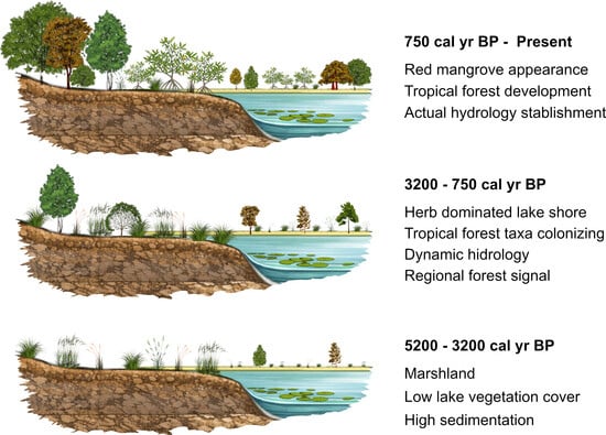
4.1. Late-Holocene Dynamics of Rhizophora mangle in Tabasco and the Wider Caribbean Context

The pattern observed in the Tabasco pollen diagram offers new insights into the temporal dynamics of mangrove colonization in the southwestern Gulf of Mexico. Unlike other Caribbean lowland sites where Rhizophora mangle expanded earlier in the Late Holocene, our data indicate that Rhizophora was absent or negligible until ca. 750 cal yr BP. This delayed appearance challenges prior generalizations regarding synchronous mangrove responses across the region and underscores the role of local geomorphic and hydrological constraints.

4.2. Mangrove Absence and Wetland Conditions Prior to 1250 cal yr BP

The basal to mid-section of the pollen core (spanning ~3200 to 1250 cal yr BP) is characterized by a consistent dominance of Poaceae, Cyperaceae, and other herbaceous wetland taxa. This composition indicates the prevalence of freshwater marsh vegetation, likely associated with dynamic deltaic conditions such as a high fluvial sediment input. The absence of Rhizophora suggests that hydrogeomorphic settings remained unfavorable for inland mangrove forest development, despite broader sea-level trends in studied coastal areas like Belize and Florida [29,30,31].
This prolonged phase of mangrove exclusion is broadly contemporaneous with episodes of heightened climatic variability recorded elsewhere in the circum-Caribbean. Regional reconstructions from Laguna Bacalar [13], Los Petenes, and Spanish Lookout Cay [29] indicate diminished Rhizophora signals between ca. 3000 and 2500 cal yr BP, attributed to a combination of ENSO intensification, ITCZ migration, and increased hurricane frequency [8]. However, in contrast to those sites—where mangrove taxa reappear shortly after 2500 cal yr BP—our data show a much later establishment in Tabasco, pointing to local hydrological inertia and the resilience of freshwater marshes under persistent deltaic influence.

4.3. Establishment and Expansion of Rhizophora mangle After 750 cal yr BP

The initial appearance of Rhizophora mangle at ~750 cal yr BP marks a significant ecological transition. This turning point likely reflects the onset of sustained sedimentary stabilization, possibly linked to delta lobe switching, estuarine deepening, or reduced fluvial sediment load. The subsequent rise in Rhizophora abundance in Laguna Cacahuate, alongside low but consistent representation of Avicennia, Laguncularia, and Conocarpus, in other paleo-records suggests the establishment of a structurally diverse mangrove vegetation.
This development coincides with regionally wetter conditions recorded across the Maya Lowlands and western Caribbean [32], including the Yucatán Peninsula and Petén, where several paleoecological records show increased precipitation and vegetative recovery following the Terminal Classic Drought [33], entering the Medieval climatic optimum. In this context, the late but abrupt appearance of Rhizophora in the Tabasco core appears consistent with a broader climatic amelioration during the last millennium. Lozano-García et al. [34] evidenced wetter conditions for Eastern Mesoamerica during the LIA (Little Ice Age) based on multiproxy data from Lago Verde (Los Tuxtlas, Mexico). Their results show higher lake levels and dense tropical forest cover during the LIA (ca. 1400–1850 CE), indicating wetter conditions rather than the drought recorded in other parts of the Caribbean. The establishment of mangroves in coastal areas during this time period may also signal a threshold response to a stabilized relative sea level [29,30].

4.4. Persistence and Stability in the Last Millennium

From ~750 cal yr BP to the present, Rhizophora mangle remains a sustained component of the pollen assemblage, showing moderate fluctuations expressed as pollen percentages in our core. This persistence suggests that hydrodynamic thresholds were surpassed, the mangrove system became self-reinforcing, supported by feedback such as peat accumulation, sediment trapping, and microclimate regulation. The co-occurrence of herbaceous and disturbance-tolerant taxa (e.g., Poaceae, Cyperaceae, Asteraceae) within this upper interval, however, implies episodic perturbations, potentially linked to tropical storm activity, river flooding, or anthropogenic impacts such as land clearing or upstream sediment diversion. Notably, the timing and trajectory of mangrove development in Tabasco contrasts with other Gulf and Caribbean sites where mangroves have a longer continuous Holocene history [35,36]. This divergence highlights the importance of site-specific sedimentary, hydrological, and geomorphological controls in regulating inland mangrove colonization and resilience. In the Tabasco delta plain, geomorphic lag and hydrological buffering likely delayed mangrove establishment, even under otherwise previously suitable climatic conditions.

4.5. The Management of the Lower Usumacinta/Candelaria River Basin

The northwestern region of the Maya lowlands covers an area of more than 63,000 km2. The river system, mainly the Candelaria River and the Usumacinta/San Pedro, favors a high hydrological dynamic of the landscape. In this region, it is estimated the presence of more than 2300 Mayan population settlements [37]. During the Holocene, hydrology was mainly determined by sea level, changes in precipitation and modifications made by human settlements [38]. During the Classic period, the region experienced a high density of human settlements that took advantage of the wealth of aquatic resources (marine and freshwater), as well as the richness of water tributaries. According to Matheny and Gurr [39], Puleston [40], Siemens et al. [41], Gunn et al. [42], and Palka [43]; the basin that encompasses the Candelaria River, Usumacinta and tributaries such as the San Pedro River, were key for the establishment of trade routes and domination of the Tikal and Calakmul states. The commercial routes kept the settlements in contact from the Gulf of Mexico to the Caribbean, taking advantage of all the tributary rivers to the Candelaria and the east Usumacinta rivers [42,44,45]. Studies in paleosols, as well as archaeological evidence, have shown intense agricultural activity in the region, as well as modifications that gave rise to “domesticated landscapes”, in which various hydraulic works were carried out in the rivers, such as dams, dykes, canals, and even small lagoons [37,38,43]. The configuration of the hydrological landscape was profound; the use of the lake plains was intensive for agricultural and aquaculture purposes. Even the configuration of wetlands and lagoons to this day is strongly associated with the management that the Chontal Maya carried out, probably in collaboration with or under the dominion of the Chacan Putun Maya. However, the management of canals, dams, and flooded fields, represented a great challenge, given that the constant discharges of sediment were determined by the runoff coming from the mountains in Chiapas and Guatemala [37]. Late-Holocene flooding processes are associated with the effects of the 6th century volcanic eruptions (~540 CE), which affected the regional precipitation system. Muñoz-Salinas et al. [38] recorded a strong discharge during 1200 BP (750 CE), which promoted a strong migration of human settlements in the northern Usumacinta/Grijalva basin, but also had effects in the Calakmul region [42].

5. Conclusions

The chronological framework reveals that the floodplain system has undergone significant environmental changes since the Early Holocene (~5200 cal yr BP). Initially (between 5200 and 3200 cal yr BP), the geochemical record indicates a period of high clastic input and unstable depositional conditions. The landscape was probably characterized by open freshwater wetlands, dominated by aquatic taxa such as Typha, Cyperaceae, and Botryococcus, indicative of standing water and marsh conditions in many regions of southern Mexico. However, as the lake system evolved under climatic drivers and volcanic activity, Rhizophora began to appear around ~750 cal yr BP, evidenced by a transition from open water wetlands to a more forested floodplain. Rhizophora populations expanded, replacing shoreline freshwater vegetation and signaling increasing hydrological stability. The Laguna Cacahuate pollen diagram confirms the broader late-Holocene narrative of Rhizophora dynamics in the western Caribbean. After a phase of instability and estuarine marsh dominance (~3000–2600 cal BP), Rhizophora mangle expanded and maintained dominance through the last two millennia at coastal areas, sustained by regional hydrological stability and possibly buffered by deltaic geomorphology in specific areas. This study also supports the idea of Krauss and Ball [46] that mangroves are facultative halophytes [47]. They can tolerate fresh water well enough to survive, though growth may be better under moderate salinity. There is no physiological evidence that mangroves require salt to complete their life cycle. The diversity of responses among species reflects a spectrum of salt tolerance, not obligate dependence. This study aimed to understand how and why these mangroves establish and persist in a non-saline environment.

Author Contributions

Conceptualization, G.A.I., C.M.B.-R. and A.A.A.-M.; methodology, G.A.I. and A.A.A.-M.; formal analysis, G.A.I., A.A.A.-M., C.M.B.-R., N.T.-V., H.A.H.-A. and J.M.A.-R.; investigation, G.A.I. and A.A.A.-M.; writing—original draft preparation, G.A.I., A.A.A.-M., C.M.B.-R., N.T.-V., H.A.H.-A. and J.M.A.-R.; writing—review and editing, G.A.I. and A.A.A.-M.; visualization, A.A.A.-M. All authors have read and agreed to the published version of the manuscript.

Funding

This work was supported by the Consejo Nacional de Humanidades, Ciencias y Tecnologías under grant number 10852.

Data Availability Statement

Data will be made available on request.

Acknowledgments

C. Burelo-Ramos and J. Ascencio-Rivera acknowledge Juárez Autonomous University of Tabasco for supporting their fieldwork. Margarito Tuz Novelo is acknowledged for help during fieldwork and Roger de Jesús Uc Escamilla for preparing pollen and geochemistry samples.

Conflicts of Interest

The authors declare no conflicts of interest. The funders had no role in the design of the study; in the collection, analyses, or interpretation of data; in the writing of the manuscript; or in the decision to publish the results.

References

  1. Osland, M.J.; Feher, L.C.; López-Portillo, J.; Day, R.H.; Suman, D.O.; Guzmán Menéndez, J.M.; Rivera-Monroy, V.H. Mangrove Forests in a Rapidly Changing World: Global Change Impacts and Conservation Opportunities along the Gulf of Mexico Coast. Estuar. Coast. Shelf Sci. 2018, 214, 120–140. [Google Scholar] [CrossRef]
  2. Valderrama-Landeros, L.H.; López-Portillo, J.; Velázquez-Salazar, S.; Alcántara-Maya, J.A.; Troche-Souza, C.; Rodríguez-Zúñiga, M.T.; Vázquez-Balderas, B.; Villeda-Chávez, E.; Cruz-López, M.I.; Ressl, R. Regional Distribution and Change Dynamics of Mangroves in México between 1970/80 and 2015. Wetlands 2020, 40, 1295–1305. [Google Scholar] [CrossRef]
  3. Velázquez-Salazar, S.; Rodríguez-Zúñiga, M.T.; Alcántara-Maya, J.A.; Villeda-Chávez, E.; Valderrama-Landeros, L.; Troche-Souza, C.; Vázquez-Balderas, B.; Pérez-Espinosa, I.; Cruz-López, M.I.; Ress, I.R.; et al. Manglares de México. Actualización Y Análisis de Los Datos 2020; Comisión Nacional para el Conocimiento y Uso de la Biodiversidad: Mexico City, Mexico, 2021. [Google Scholar]
  4. Maxwell, T.L.; Spalding, M.D.; Friess, D.A.; Murray, N.J.; Rogers, K.; Rovai, A.S.; Smart, L.S.; Weilguny, L.; Adame, M.F.; Adams, J.B.; et al. Soil Carbon in the World’s Tidal Marshes. Nat. Commun. 2024, 15, 10265. [Google Scholar] [CrossRef]
  5. Alongi, D.M. Mangrove Forests: Resilience, Protection from Tsunamis, and Responses to Global Climate Change. Estuar. Coast. Shelf Sci. 2008, 76, 1–13. [Google Scholar] [CrossRef]
  6. Portillo, J.L.; Ezcurra, E. Los Manglares de México: Una Revisión. Madera Bosques 2002, 8, 27–51. [Google Scholar] [CrossRef]
  7. Rull, V. Rise and Fall of Caribbean Mangroves. Sci. Total Environ. 2023, 885, 163851. [Google Scholar] [CrossRef]
  8. Aragón-Moreno, A.A.; Islebe, G.A.; Roy, P.D.; Torrescano-Valle, N.; Mueller, A.D. Climate Forcings on Vegetation of the Southeastern Yucatán Peninsula (Mexico) during the Middle to Late Holocene. Palaeogeogr. Palaeoclimatol. Palaeoecol. 2018, 495, 214–226. [Google Scholar] [CrossRef]
  9. Monacci, N.M.; Meier-Grünhagen, U.; Finney, B.P.; Behling, H.; Wooller, M.J. Paleoecology of Mangroves along the Sibun River, Belize. Quat. Res. 2011, 76, 220–228. [Google Scholar] [CrossRef]
  10. Goldberg, L.; Lagomasino, D.; Thomas, N.; Fatoyinbo, T. Global Declines in Human-Driven Mangrove Loss. Glob. Change Biol. 2020, 26, 5844–5855. [Google Scholar] [CrossRef] [PubMed]
  11. Rull, V. Origin and Evolution of Caribbean Mangroves: A Time-Continuum Ecological Approach, 2024th ed.; Ecological Studies: Analysis and Synthesis; Springer International Publishing: Cham, Switzerland, 2024. [Google Scholar]
  12. Rull, V. Responses of Caribbean Mangroves to Quaternary Climatic, Eustatic, and Anthropogenic Drivers of Ecological Change: A Review. Plants 2022, 11, 3502. [Google Scholar] [CrossRef]
  13. Aragón-Moreno, A.A.; Islebe, G.A.; Torrescano-Valle, N.; Hernández-Arana, H.A.; Carrillo-Bastos, A.; Friedel, R. Mangrove Dynamics Driven by Late Holocene Drought at Laguna Bacalar, Mexico. Quat. Environ. Hum. 2024, 2, 100023. [Google Scholar] [CrossRef]
  14. Aburto-Oropeza, O.; Burelo-Ramos, C.M.; Ezcurra, E.; Ezcurra, P.; Henriquez, C.L.; Vanderplank, S.E.; Zapata, F. Relict Inland Mangrove Ecosystem Reveals Last Interglacial Sea Levels. Proc. Natl. Acad. Sci. USA 2021, 118, e2024518118. [Google Scholar] [CrossRef]
  15. Peralta-Carreta, C.; Medrano-Pérez, O.R.; Alcudia-Aguilar, A.; Pham, Q.B.; Megia-Vera, H.J. Spatial Distribution of Relict Inland Mangrove (Rhizophora mangle L.) in the San Pedro River Basin: A Transboundary Analysis between Mexico and Guatemala. Estuaries Coast. 2025, 48, 59. [Google Scholar] [CrossRef]
  16. Hellmuth, N.; Jerez, S.D.; López Dobrusin, E.; Morales Rodríguez, N.; Mendoza, V. (Eds.) Mangle Rojo (Rhizophora mangle) en las Riberas del Río San Pedro; FLAAR Mesoamérica: Guatemala City, Guatemala, 2024. [Google Scholar]
  17. CONANP. Programa de Manejo Área de Protección de Flora y Fauna Cañon del Usumacinta; Secretaría de Medio Ambiente, Recursos Naturales & Pesca: Mexico City, Mexico, 2015. [Google Scholar]
  18. CONANP. Estudio Previo Justificativo Para el Establecimiento del Área Natural Protegida Reserva de la Biósfera Wanha’ Tabasco; CONANP: Mexico City, Mexico, 2023. [Google Scholar]
  19. Faegri, K.; Iversen, J. Textbook of Pollen Analysis, 4th ed.; Faegri, K., Kaland, P.E., Krzywinski, K., Eds.; John Wiley: Hoboken, NJ, USA, 1989. [Google Scholar]
  20. Palacios-Chávez, R.; Ludlow-Wiechers, B.; Villanueva, R. Flora Palinológica de La Reserva de La Biosfera de Sian Ka’an, Quintana Roo, México; Centro de Investigaciones de Quintana Roo: Chetumal, Mexico, 1991. [Google Scholar]
  21. Grimm, E.C. Tilia, version 1.7.16; Illinois State Museum, Research and Collection Center: Springfield, IL, USA, 2011. [Google Scholar]
  22. Navarro, E.; Daesslé, L.W.; Camacho-Ibar, V.F.; Ortiz-Hernández, M.C.; Gutiérrez-Galindo, E.A. La geoquímica de Fe, Ti y Al como indicadora de la sedimentación volcanoclástica en la laguna costera de San Quintín, Baja California, México. Cienc. Mar. 2006, 32, 205–217. [Google Scholar] [CrossRef]
  23. Urrego, L.E.; Correa-Metrio, A.; González, C.; Castaño, A.R.; Yokoyama, Y. Contrasting Responses of Two Caribbean Mangroves to Sea-Level Rise in the Guajira Peninsula (Colombian Caribbean). Palaeogeogr. Palaeoclimatol. Palaeoecol. 2013, 370, 92–102. [Google Scholar] [CrossRef]
  24. Bocanegra-Ramírez, D.M.; Li, H.-C.; Vázquez, G.D.; Israde-Alcántara, I.; Bischoff, J.L. Holocene Climate Change and Sea Level Oscillations in the Pacific Coast of Mexico. Quat. Int. 2019, 528, 100–108. [Google Scholar] [CrossRef]
  25. Espíndola, J.M.; Macías, J.L.; Tilling, R.I.; Sheridan, M.F. Volcanic History of El Chichón Volcano (Chiapas, Mexico) during the Holocene, and Its Impact on Human Activity. Bull. Volcanol. 2000, 62, 90–104. [Google Scholar] [CrossRef]
  26. Macías, J.L.; Arce, J.L.; Mora, J.C.; Espíndola, J.M.; Saucedo, R.; Manetti, P. A 550-year-old Plinian Eruption at El Chichón Volcano, Chiapas, Mexico: Explosive Volcanism Linked to Reheating of the Magma Reservoir. J. Geophys. Res. 2003, 1–18. [Google Scholar] [CrossRef]
  27. Nooren, C.; Hoek, W.; Tebbens, L.; Pozzo, A. Tephrochronological Evidence for the Late Holocene Eruption History of El Chichón Volcano, Mexico. Geofis. Int. 2009, 48, 97–112. [Google Scholar] [CrossRef]
  28. Tilling, R.I.; Rubin, M.; Sigurdsson, H.; Carey, S.; Duffield, W.A.; Rose, W.I. Holocene Eruptive Activity of El Chichón Volcano, Chiapas, Mexico. Science 1984, 224, 747–749. [Google Scholar] [CrossRef] [PubMed]
  29. Monacci, N.M.; Meier-Grünhagen, U.; Finney, B.P.; Behling, H.; Wooller, M.J. Mangrove Ecosystem Changes during the Holocene at Spanish Lookout Cay, Belize. Palaeogeogr. Palaeoclimatol. Palaeoecol. 2009, 280, 37–46. [Google Scholar] [CrossRef]
  30. Jones, M.C.; Wingard, G.L.; Stackhouse, B.; Keller, K.; Willard, D.; Marot, M.; Landacre, B.; E Bernhardt, C. Rapid Inundation of Southern Florida Coastline despite Low Relative Sea-Level Rise Rates during the Late-Holocene. Nat. Commun. 2019, 10, 3231. [Google Scholar] [CrossRef]
  31. Yao, Q.; Liu, K.-B.; Platt, W.J.; Rivera-Monroy, V.H. Palynological Reconstruction of Environmental Changes in Coastal Wetlands of the Florida Everglades since the Mid-Holocene. Quat. Res. 2015, 83, 449–458. [Google Scholar] [CrossRef]
  32. Medina-Elizalde, M.; Rohling, E.J. Collapse of Classic Maya Civilization Related to Modest Reduction in Precipitation. Science 2012, 335, 956–959. [Google Scholar] [CrossRef]
  33. Medina-Elizalde, M.; Burns, S.J.; Polanco-Martínez, J.M.; Beach, T.; Lases-Hernández, F.; Shen, C.-C.; Wang, H.-C. High-Resolution Speleothem Record of Precipitation from the Yucatan Peninsula Spanning the Maya Preclassic Period. Glob. Planet. Change 2016, 138, 93–102. [Google Scholar] [CrossRef]
  34. Lozano-García, M.d.S.; Caballero, M.; Ortega, B.; Rodriguez, A.; Sosa, S. Tracing the Effects of the Little Ice Age in the Tropical Lowlands of Eastern Mesoamerica. Proc. Natl. Acad. Sci. USA 2007, 104, 16200–16203. [Google Scholar] [CrossRef] [PubMed]
  35. Islebe, G.A.; Carrillo-Bastos, A.; Aragón-Moreno, A.A.; Valdez-Hernández, M.; Torrescano-Valle, N.; Cabanillas-Terán, N. Holocene Paleoecology and Paleoclimatology of South and South-Eastern Mexico: A Palynological and Geospatial Approach. In The Holocene and Anthropocene Environmental History of Mexico: A Paleoecological Approach on Mesoamerica; Torrescano-Valle, N., Islebe, G.A., Roy, P., Eds.; Springer: Cham, Switzerland, 2019; pp. 195–208. [Google Scholar]
  36. Wooller, M.J.; Behling, H.; Smallwood, B.J.; Fogel, M. Mangrove Ecosystem Dynamics and Elemental Cycling at Twin Cays, Belize, during the Holocene. J. Quat. Sci. 2004, 19, 703–711. [Google Scholar] [CrossRef]
  37. Liendo, R.; Solleiro-Rebolledo, E.; Solis-Castillo, B.; Sedov, S.; Ortiz-Pérez, A. 7 Population Dynamics and Its Relation to Ancient Landscapes in the Northwestern Maya Lowlands: Evaluating Resilience and Vulnerability: Evaluating Resilience and Vulnerability. Archeol. Pap. Am. Anthropol. Assoc. 2014, 24, 84–100. [Google Scholar]
  38. Muñoz-Salinas, E.; Cook, D.; Castillo, M.; Beach, T.; Luzzadder-Beach, S. Four Millennia of Geomorphic Change and Human Settlement in the Lower Usumacinta–Grijalva River Basin, Mexico. Prog. Phys. Geogr. 2023, 47, 227–248. [Google Scholar] [CrossRef]
  39. Matheny, R.; Gurr, D. Variation in Prehistoric Agricultural Systems of the New World. Annu. Rev. Anthropol. 1983, 12, 79–103. [Google Scholar] [CrossRef]
  40. Puleston, D.E. Terracing, Raised Fields, and Tree Cropping in the Maya Lowlands: A New Perspective on the Geography of Power. In Prehispanic Maya Agriculture; Harrison, P.D., Turner, B.L., Eds.; University of New Mexico Press: Albuquerque, NM, USA, 1978; pp. 225–246. [Google Scholar]
  41. Siemens, A.; Graham, J.A.; Hebda, R.; Heimo, M. “DAMS” on the Candelaria. Anc. Mesoam. 2002, 13, 115–123. [Google Scholar] [CrossRef]
  42. Gunn, J.D.; Folan, W.J.; Torrescano-Valle, N.; Faust, B.B.; Geovannini-Acuña, H.Z.; Siemens, A.H. From Calakmul to the Sea: The Historical Ecology of a Classic Maya City That Controlled the Candelaria/champoton Watersheds. In The Holocene and Anthropocene Environmental History of Mexico; Springer International Publishing: Cham, Switzerland, 2019; pp. 209–248. [Google Scholar]
  43. Palka, J. Ancestral Maya Domesticated Waterscapes, Ecological Aquaculture, and Integrated Subsistence. Anc. Mesoam. 2023, 35, 208–236. [Google Scholar] [CrossRef]
  44. Woodfill, B.K.S.; Andrieu, C. Tikal’s Early Classic Domination of the Great Western Trade Route: Ceramic, Lithic, and Iconographic Evidence. Anc. Mesoam. 2012, 23, 189–209. [Google Scholar] [CrossRef]
  45. Freidel, D.; Escobedo, H.; Lee, D.; Guenter, S.; Meléndez, J.C. El Perú-Waka’ Y La Ruta Terrestre de La Dinastía Kan Hacia El Altiplano. In XX Simposio de Investigaciones Arqueológicas en Guatemala; Laporte, J.P., Arroyo, B., Mejía, H., Eds.; Museo Nacional de Arqueología y Etnología: Guatemala City, Guatemala, 2006; pp. 59–76. [Google Scholar]
  46. Krauss, K.W.; Ball, M.C. On the Halophytic Nature of Mangroves. Trees 2013, 27, 7–11. [Google Scholar] [CrossRef]
  47. Flowers, T.J.; Colmer, T.D. Salinity Tolerance in Halophytes. New Phytol. 2008, 179, 945–963. [Google Scholar] [CrossRef] [PubMed]
Figure 1. Study area. Core location (A) and laguna settings (BE). B individual R. mangle tree, (C) aerial view of Laguna El Cacahuate, (D) lake view with floating Nymphaea ampla and shoreline mangroves, (E) closeup of shore vegetation of Laguna El Cacahuate. Photographs: (B) Gerald Islebe; (C) Neil Morales; (D,E) Manuel Campos.
Forests 17 00303 g001
Figure 2. Age–depth model of Laguna El Cacahuate.
Forests 17 00303 g002
Figure 3. Pollen percentage diagram of Laguna El Cacahuate. Taxa grouped according to vegetation type. Rhizophora mangle (light blue colored) was the only mangrove species present in the area. Other taxa grouped in Tropical Forest (green colored), Disturbance vegetation (yellow colored), and Montane elements (blue colored), and were used for the pollen sum.
Forests 17 00303 g003
Figure 4. Geochemistry of the core Laguna El Cacahuate. X-ray fluorescence of elements present in sediments and element ratios.
Forests 17 00303 g004
Figure 5. Overview of paleoecological history of Laguna El Cacahuate based on geochemical and palynological analysis.
Forests 17 00303 g005
Table 1. Radiocarbon ages of core Laguna El Cacahuate. Reported ages are calibrated at 2σ.
ICA IDDepth (cm)Conventional Age (yr BP)Material
14C-664143290 ± 30 BPorganic sediment
14C-664267840 ± 30 BPorganic sediment
14C-6643811580 ± 30 BPorganic sediment
14C-66441136810 ± 30 BPseed
14C-66451694380 ± 40 BPorganic sediment
Disclaimer/Publisher’s Note: The statements, opinions and data contained in all publications are solely those of the individual author(s) and contributor(s) and not of MDPI and/or the editor(s). MDPI and/or the editor(s) disclaim responsibility for any injury to people or property resulting from any ideas, methods, instructions or products referred to in the content.

