Article

Physical-Hydric Properties of a Planosols Under Long-Term Integrated Crop–Livestock–Forest System in the Brazilian Semiarid †

by
Valter Silva Ferreira
1,
Flávio Pereira de Oliveira
1,
Pedro Luan Ferreira da Silva
2,
Adriana Ferreira Martins
1,
Walter Esfrain Pereira
3,
Djail Santos
1,
Tancredo Augusto Feitosa de Souza
1,
Robson Vinício dos Santos
4 and
Milton César Costa Campos
1,*
1
Postgraduate Program in Soil Science, Department of Soils and Rural Engineering, Federal University of Paraíba—Campus II, Areia 58397-000, PB, Brazil
2
Postgraduate Program in Agronomy (PGA), State University of Maringá, Maringá 87020-900, PR, Brazil
3
Postgraduate Program in Soil Science, Department of Fundamental and Social Sciences, Federal University of Paraíba—Campus II, Areia 58397-000, PB, Brazil
4
Graduate in Agronomy, Federal University of Paraíba—Campus II, Areia 58397-000, PB, Brazil
*
Author to whom correspondence should be addressed.
This manuscript is part of a Master’s dissertation by the Valter Ferreira da Silva, Available online: https://drive.google.com/file/d/1OQFwnLMCUdmRWNYMQ3ZXQy6IXtZKgbX6/view.
Forests 2025, 16(8), 1261; https://doi.org/10.3390/f16081261 (registering DOI)
Submission received: 22 May 2025 / Revised: 18 July 2025 / Accepted: 24 July 2025 / Published: 2 August 2025
(This article belongs to the Special Issue Forest Soil Physical, Chemical, and Biological Properties)

Abstract

The objective of this study was to evaluate the physical-hydric properties of a Planosol under an Integrated Crop–Livestock–Forest (ICLF) system in the Agreste region of Paraíba, Brazil, after eight years of implementation, and to compare them with areas under a conventional cropping system and secondary native vegetation. The experiment was conducted at the experimental station located in Alagoinha, in the Agreste mesoregion of the State of Paraíba, Brazil. The experimental design adopted was a randomized block design (RBD) with five treatments and four replications (5 × 4 + 2). The treatments consisted of: (1) Gliricidia (Gliricidia sepium (Jacq.) Steud) + Signal grass (Urochloa decumbens) (GL+SG); (2) Sabiá (Mimosa caesalpiniaefolia Benth) + Signal grass (SB+SG); (3) Purple Ipê (Handroanthus avellanedae (Lorentz ex Griseb.) Mattos) + SG (I+SG); (4) annual crop + SG (C+SG); and (5) Signal grass (SG). Two additional treatments were included for statistical comparison: a conventional cropping system (CC) and a secondary native vegetation area (NV), both located near the experimental site. The CC treatment showed the lowest bulk density (1.23 g cm−3) and the lowest degree of compaction (66.3%) among the evaluated treatments, as well as a total porosity (TP) higher than 75% (0.75 m3 m−3). In the soil under the integration system, the lowest bulk density (1.38 g cm−3) and the highest total porosity (0.48 m3 m−3) were observed in the SG treatment at the 0.0–0.10 m depth. High S-index values (>0.035) and a low relative field capacity (RFc < 0.50) and Kθ indicate high structural quality and low soil water storage capacity. It was concluded that the SG, I+SG, SB+SG, and CC treatments presented the highest values of soil bulk and degree of compaction in the layers below 0.10 m. The I+SG and C+SG treatments showed the lowest hydraulic conductivities and macroaggregation. The SG and C+SG treatments had the lowest available water content and available water capacity across the three analyzed soil layers.

Graphical Abstract

1. Introduction

Agriculture and livestock play one of the most important roles in Brazil’s national economy, accounting for the highest levels of grain and meat production and export worldwide. According to data, agricultural activities occupy approximately 30.9% of the entire national territory. While these figures are currently seen as positive, over the years, extensive livestock farming in Brazil has led to pasture degradation, deforestation, and increased greenhouse gas emissions [1], as traditional technologies fail to ensure economically sustainable production without causing the physical, chemical, and biological degradation of the soil [2].
Considering the environmental damage caused by conventional farming and livestock practices, the past few decades have seen a growing search for low-impact technologies to improve soil conservation, historically the primary foundation of food production. According to [3,4], sustainable agricultural development, in addition to prioritizing biodiversity conservation and environmental stewardship, also encompasses issues such as maintaining soil and water quality, reducing environmental contamination, and enabling natural practices such as biological control, weed and plant disease management, and the sustainable use of natural resources and ecosystems. The ultimate goal is to reduce human-induced degradation and improve the production of food demanded by the market.
It is well known that innovation does not always align with sustainable development. However, transitioning from agriculture based on unsustainable models to more sustainable farming systems helps reorient production processes to reduce environmental harm and enhance socioeconomic inclusion. This shift directly impacts the availability of healthy products and food for the consumer market [5].
Over time, various management systems and land uses have been developed to improve soil quality and allow additional elements to be integrated into production systems, bringing them closer to the natural conditions in ecosystems. Therefore, maintaining or even enhancing soil quality through sustainable production systems is essential for promoting food and nutritional security without compromising the balance among the soil chemical, physical, and biological properties, which are critical for the performance of its ecosystem functions [6].
In this context, among the technologies used for soil and environmental conservation, integrated systems can combine different production approaches, including livestock and non-livestock components. One of the most well-known systems is the Integrated Crop–Livestock–Forest system (ICLFS), in which the production environment is shared among crop cultivation, livestock raising, and forestry. ICLFSs offer numerous benefits, such as pasture production, grain cultivation, and the contribution of forest species to atmospheric CO2 sequestration through photosynthesis and the subsequent incorporation of organic matter into the soil [7]. In addition to improving soil fertility, these systems help maintain adequate water infiltration, enhance nutrient cycling, promote soil carbon retention, and improve the soil’s structural, chemical, and biological properties.
Many soils have undergone various pedogenetic processes in arid and semiarid regions, often leading to degradation and, in more severe cases, to highly degraded and unproductive soils. This land degradation in arid, semiarid, and dry sub-humid climates results in a decline or loss of the biological or economic productivity of rainfed and irrigated croplands, pastures, forests, and woodlands, stemming from land use or a combination of processes driven by human activities and settlement patterns [8]. In these drylands, desertification occurs, which is understood as a set of processes that gradually lead to soil loss or a decline in productive capacity, vegetation suppression, and the deterioration of water bodies [8]. Adopting Integrated Crop–Livestock (ICL) or Integrated Crop–Livestock–Forest (ICLF) systems can contribute to conserving these soils.
In the northeast of Brazil, farmers adopt the rainfed production system, often in areas where the soil has chemical, physical, and biological limitations. Planosols are widely used in the northeastern semiarid and Agreste areas for farming and the cultivation of subsistence crops such as maize, cotton, and beans [9]. However, there are physical limitations such as low effective depth, the presence of a normally dense B horizon, and difficulty in infiltrating and storing water. The sandy surface layer of Planosols can make them susceptible to increased compaction when subjected to animal trampling in the short term [10], making this soil an environment with minimal suitable conditions for crop development.
Most studies on soils under integrated agricultural production systems have been carried out in the south and center-west regions of Brazil, focusing on Argissolos and Latossolos [4]. In the semiarid region, the adoption of this type of production system is recent, and the response of the soil’s physical attributes to this management system generally occurs in the medium to long term. For this reason, we are testing the hypothesis that in the medium and long term the response of physical soil quality parameters is different between the different arrangements (systems) in conditions close to the local native vegetation. Including these variables is expected to enhance the estimation of soil water retention functions in systems that incorporate shrub and tree components, compared to conventional cropping systems and native vegetation.
In this context, the present study aimed to evaluate the physical and hydraulic properties of a Planosols, identify physical soil quality indicators under an Integrated Crop–Livestock–Forest (ICLF) system in the Agreste region of Paraíba after eight years of implementation, and compare them to areas under a conventional cropping system and native vegetation.

2. Materials and Methods

2.1. Location and Characteristics of the Site

The experiment was conducted at the experimental station of the Paraíba State Company for Agricultural Research, Rural Extension, and Land Regularization (EMPAER), located in the municipality of Alagoinha, in the Agreste mesoregion of the state of Paraíba, at 06°57′00″ S and 35°32′42″ W (Figure 1) and an altitude of 317 m.
According to the Köppen–Geiger classification, the region’s climate is the (As) type, hot and humid with rainfall in autumn and winter. The average annual precipitation is 995 mm, with the rainy season spanning from March to August. The average annual temperature ranges between 22 °C and 26 °C. The soil in the experimental area is classified as a Planossolo Háplico eutrophic mesic solodic with a moderate A horizon and sandy loam texture, according to the Brazilian Soil Classification System (SiBCS) [11], corresponding to Planosols [12].

2.2. Experimental Design

The field experiment was established in July 2015. A randomized block design (RBD) was used, with five treatments and four replications (5 × 4 + 2). The treatments consisted of: (1) Gliricidia (Gliricidia sepium (Jacq.) Steud) + Signal grass (Urochloa decumbens) (GL+SG); (2) Sabiá (Mimosa caesalpiniaefolia Benth) + Signal grass (SB+SG); (3) Purple Ipê (Handroanthus avellanedae (Lorentz ex Griseb.) Mattos) + Signal grass (I+SG); (4) annual crop + Signal grass (C+SG); and (5) Signal grass (SG). Two additional treatments were included for statistical comparison: a conventional cropping system (CC) and a secondary native vegetation area (NV), both located near the experimental site.
The forest species were planted in triple rows, spaced 3 × 2 m, along the edges of each plot, totaling six rows per plot, while corn was planted using a no-till system. Each experimental plot measured 38 × 20 m, totaling an area of 760 m2. The soil in the experimental area was classified as Planosols with a moderate A horizon and sandy loam texture [9]. The tables below show the physical and chemical characteristics of the soil in the experimental area before the experiment (Table 1 and Table 2), where ten simple samples were collected for the experiment.

2.3. Collection, Sample Preparation, and Soil Characterization

Soil samples used to determine variables were collected in two forms: undisturbed and disturbed. Uhland-type volumetric rings with a volume of 102.09 cm3 were used for sampling. Immediately after collection, the samples were sent to the Soil Physical Analysis Laboratory of the Department of Soil and Rural Engineering (DSENGR) at the Federal University of Paraíba (UFPB) for analysis.

2.4. Particle Size Distribution, Bulk Density, Pore Volume, Soil Hydraulic Conductivity, and Soil Water Dynamics

The deformed samples, after air-drying, were crushed and sieved through a 2.0 mm mesh to determine texture and flocculation degree, following the methodology described in [13]. For the remaining variables, undisturbed soil samples were collected using metal cylinders with a volume of 98.17 cm3.
Bulk density (Bd) was determined following the methodology proposed in [14], by calculating the ratio between the oven-dry mass of the soil and the sample volume, as described in Equation (1):
Bd (g cm−3) = msdry/v
where Bd = soil bulk density (g cm−3); msdry = mass of oven-dried soil maintained at ±105 °C for a minimum of 48 h or until constant weight is reached; and v = volume of the soil sample in the cylinder.
Soil particle density (Pd; g cm−3) was determined using the volumetric flask method, following the procedure described in the manual of soil analysis methods by the Brazilian Agricultural Research Corporation—EMBRAPA [13]. Maximum bulk density (Bdmax) and relative bulk density (BdRelative) were determined according to [15], using a pedotransfer function (PTF). The calculation of Bdmax considered the clay content and organic matter content of the soil for each treatment. Relative bulk density (BdRelative) was estimated as the ratio between Bdmax and bulk density (Bd), as shown in Equations (2) and (3):
Bdmax (g cm−3) = 2.03133855 − 0.00320878 SOM − 0.00076508 × Clay
BdRelative = Bd/Bdmax
where Bdmax = maximum bulk density (g cm−3); SOM = soil organic matter content (g kg−1); Clay = clay content of the soil sample (g kg−1); and BdRelative = relative bulk density (dimensionless).
Using the bulk density (Bd) and maximum bulk density (Bdmax) data, it was possible to estimate the degree of soil compaction (DC), which defines the percentage of compaction relative to the maximum density, according to the methodology proposed in [16]. The equation used to calculate DC is presented below by Equation (4):
DC (%) = (Bd/Bdmax) × 100
where DC = degree of compaction (%); Bd = soil bulk density (g cm−3); and Bdmax = maximum bulk density (g cm−3).
Saturated hydraulic conductivity of the soil (Kθ) was determined following the methodology proposed in [13]. Equation (5) is used to obtain the saturated hydraulic conductivity (Kθ) values, expressed in cm h−1.
(Kθ) = Q × L/A × H × t
where Kθ = saturated hydraulic conductivity (cm h−1); Q = volume of percolated water collected in a graduated cylinder (mL); L = height of the soil core (cm); A = cross-sectional area of the cylinder (cm2); H = height of the soil core plus the water layer (cm); and t = time in hours for water percolation.
Total soil porosity (TP, m3 m−3) was determined using two methods: (1) based on the soil moisture corresponding to the saturation volume, referred to as the estimated total porosity (ϕTP), and (2) through the ratio between soil bulk density and particle density, referred to as the calculated total porosity [13].
Soil microporosity (Mi) was determined using a matric potential of Ψm = −6 kPa on a tension table for at least 72 h or until drainage ceased from pores larger than 0.05 mm. Soil macroporosity (Ma) was obtained by the difference between the TP and soil microporosity (Mi) (θ0 − θ−6 kPa).
Soil aeration capacity (SAC) is an important indicator of soil quality and is determined using the methodology proposed in [17]. Saturated soil samples and the water content at field capacity (θFC—m3 m−3) are used to calculate SAC. The equation used to calculate soil aeration capacity (SAC) is presented below by Equation (6):
SAC (m3 m−3) = θS − θFC
where SAC = soil aeration capacity (m3 m−3); θS = saturated soil moisture at a matric potential of Ψm = 0 (m3 m−3); and θFC = field capacity determined in a Richards chamber with a porous plate at a tension of −10 kPa (m3 m−3).
As an important indicator of soil quality, SAC values should generally be ≥0.10 m3 m−3 (or 10%) to ensure a balance between water volume and gas diffusion in the soil. For sandy-textured soils, such as those classified as sandy loam, a minimum SAC value of >0.14 m3 m−3 is required [18].
Relative aeration capacity (θRAC) is a physical variable used to assess soil moisture concerning the minimum threshold for adequate soil aeration. In other words, it represents the minimum soil moisture level at which the aeration capacity equals SAC = 0.10 m3 m−3. Its determination followed the methodology proposed in [19] and was calculated using Equation (7):
θRAC (m3 m−3) = [1 − (Bd/Pd)] − 0.1
where θRAC = relative aeration capacity (m3 m−3); Bd = soil bulk density (g cm−3); Pd = particle density (g cm−3); and 0.1 represents the minimum threshold for adequate soil aeration capacity (m3 m−3).
Field capacity (θFC), permanent wilting point (θPWP), and plant-available water (θAW) were determined following the methodologies proposed by Richards (1947) [20] and Reichardt (1988) [21], by applying matric potentials to undisturbed soil samples using a Richards chamber with a porous plate. As the soil is sandy, a matric potential of Ψm = −10 kPa was used for the field capacity (θFC) and Ψm = −1.500 kPa for the permanent wilting point (θPWP). Plant-available water (θAW) was obtained as the difference between θFC and θPWP, according to [22]. The calculations for θFC and θPWP were performed using Equations (8)–(10):
θFC (m3 m−3) = θ (Ψ − 10 kPa) − Msdry/volume
θPWP (m3 m−3) = θ (Ψ − 1.500 kPa) − Msdry/volume
θAW (m3 m−3) = θFC − θpwp
where θFC = field capacity, corresponding to the water volume at a matric potential of Ψ = −10 kPa (m3 m−3); θPWP = permanent wilting point, corresponding to the water volume at a matric potential of Ψ = −1.500 kPa (m3 m−3); Msdry = oven-dry soil mass (g); Volume = volume of the volumetric ring (cm3); and θAW = plant-available water (m3 m−3).
The θPWP is functionally defined as the soil moisture level at which plants wilt and are no longer able to recover turgor, even when placed in a dark, humid chamber or following rainfall or irrigation [23].
Available water capacity (AWC) was calculated using the following Equation (11):
AWC (mm) = θAW × Bd × Z
where AWC = available water capacity in the soil (mm); Bd = soil bulk density of the soil layer; Z = thickness of the evaluated soil layer (mm).
Relative field capacity (RFc) was determined according to [17]. The equation used to calculate the relative field capacity (RFc) is as follows:
RFc = (θFCS) = [1 − (SAC/θS)]
where RFc = relative field capacity (dimensionless); θFC = field capacity, corresponding to the water volume at a matric potential of Ψ = −10 kPa (m3 m−3); θS = saturated soil moisture (Ψm = 0, m3 m−3); and SAC = soil aeration capacity (m3 m−3). The soil structural quality index (S-index) is equivalent to the slope of the soil water retention curve (SWRC) and was estimated according to [24].

2.5. Statistical Analysis

The data was subjected to the Shapiro–Wilk normality test and logarithmically transformed if necessary or presented using the median. Once the assumptions had been made, all the parameters were subjected to an analysis of variance (ANOVA), and means were compared using the Tukey test at a significance level of p < 0.05. The data were also evaluated using the Pearson correlation (r) at significance levels of p < 0.1, 0.05, and 0.01. Statistical analyses were performed using R software—R versão 3.0.2 [25].
For interpreting the Pearson linear correlation coefficient (r), the following criteria were adopted: 0.7 ≤ r ≤ 1.0 for strong correlations; 0.4 ≤ r < 0.6 for moderate correlations; 0.1 ≤ r < 0.3 for weak correlations; and 0.0 ≤ r < 0.1 for negligible correlations. Furthermore, it is important to note that the correlation coefficient (r) ranges from −1 to 1. The absolute value indicates the strength of the relationship between variables, while the sign indicates the positive or negative direction of the relationship.

3. Results

3.1. Sand, Silt, and Clay Contents

Table 3 presents the mean values for particle size distribution (sand, silt, and clay), flocculation degree (FD), and the textural classification of the Planosols under an Integrated Crop–Livestock–Forest system across three soil layers (0.00–0.10; 0.10–0.20; and 0.20–0.30 m), as well as under native vegetation and conventional cropping. A higher predominance of the sand fraction was observed, with mean values of 635 g kg−1 in the 0.00–0.10 m layer, 623 g kg−1 in the 0.10–0.20 m layer, and 605 g kg−1 in the 0.20–0.30 m layer. Silt content showed mean values of 167, 164, and 168 g kg−1 for the 0.00–0.10, 0.10–0.20, and 0.20–0.30 m soil layers, respectively. The clay content increased with depth, with mean values of 198 g kg−1 in the 0.00–0.10 m layer, 214 g kg−1 in the 0.10–0.20 m layer, and 224 g kg−1 in the 0.20–0.30 m layer.
The flocculation degree (FD) (Table 3) did not show statistically significant differences (p < 0.05), with the highest value observed in the C+SG at 859 g kg−1 in the 0.10–0.20 m layer and the lowest in the SB+SG treatment at 682 g kg−1 in the 0.00–0.10 m layer, both of which did not differ statistically from the other treatments. Silva et al. (2019) [26], evaluating physical soil attributes under an Integrated Crop–Livestock–Forest system in Planosols, found similar FD values in the 0.00–0.10, 0.10–0.20, and 0.20–0.30 m layers.

3.2. Physico-Hydrical Properties in PLANOSOLS

Table 4 presents the mean values for soil bulk density (Bd), maximum bulk density (Bdmax), relative bulk density (BdRelative), compaction degree (DC), and saturated hydraulic conductivity (Kθ). A statistically significant variation (p < 0.05) was observed among the evaluated treatments, particularly in the 0.00–0.10 m layer, and significant differences in the maximum bulk density were found across all soil layers. Bulk density ranged from 1.31 to 1.54 g cm−3, maximum bulk density (Bdmax) from 1.78 to 1.91 g cm−3, relative bulk density from 0.66 to 0.83, DC from 66.3% to 81.9%, and saturated hydraulic conductivity (Kθ) from 0.0343 to 0.0395 cm h−1.
Bd in the 0.00–0.10 m layer ranged from 1.23 to 1.53 g cm−3, showing a significant difference (p < 0.05) among the SG, C+SG, NV, and CC treatments (Table 4). The highest Bd values were observed in the SG in the 0.10–0.20 m layer and the C+SG treatment in the 0.20–0.30 m layer, both reaching 1.53 g cm−3, while the lowest value was found in the CC treatment with a density of 1.23 g cm−3.
Bdmax values ranged from 1.78 to 1.91 g cm−3. However, significant differences in Bdmax were observed across all soil layers. In the 0.00–0.10 m layer, only the NV and CC treatments differed statistically, with maximum densities of 1.80 and 1.85 g cm−3, respectively. In the 0.10–0.20 m layer, treatments that showed statistical differences were NV (1.79 g cm−3), CC (1.83 g cm−3), and I+SG (1.86 g cm−3). In the 0.20–0.30 m layer, only NV and CC treatments showed statistically distinct values with 1.78 and 1.83 g cm−3, respectively.
Table 5 shows the mean values for physical attributes related to the soil pore space: estimated total porosity (ϕTP), calculated total porosity (TP), macroporosity (Ma), microporosity (Mi), soil aeration capacity (SAC), and relative aeration capacity (θRAC). On average, no statistically significant variation (p < 0.05) was observed in estimated total porosity (ϕTP). The lowest value recorded was 0.42 m3 m−3, observed in the SG treatment in the 0.10–0.20 m layer, and in the I+SG and C+SG treatments in the 0.20–0.30 m layer. The highest estimated porosity was found in the CC treatment in the 0.00–0.10 m layer, with a value of 0.75 m3 m−3. The areas with the conventional cropping system and native vegetation showed consistently high estimated porosity values across all layers, ranging from 0.69 to 0.75 m3 m−3.
Table 6 presents the mean values for field capacity (θFC), permanent wilting point (θPWP), available water (θAW), available water capacity (AWC), relative field capacity (RFc), and the S-index. Statistically significant differences (p < 0.05) were observed for all analyzed variables, except for the structural soil quality (S-index), which did not show significant differences among soil layers.

3.3. Pearson Correlation

The correlation coefficients for selected physical properties of the studied Planosols, considering five treatment types within the integrated system and two additional treatments, are presented in Table 7.

4. Discussion

4.1. Sand, Silt, and Clay Contents

A greater predominance of the sand fraction was observed in all layers. However, the clay content increased with depth.
A strong negative correlation was observed between the flocculation degree (FD) and plant-available water (AW) (r = −0.75) in Signal grass (SG) treatment (Table 7). On the other hand, in the treatment under native vegetation, a positive correlation was observed, associated with the high content of total clay and the low content of clay dispersed in water (Table 3).
FD is an analysis that indicates the proportion of the flocculated clay fraction, providing information on the stability of soil aggregates [13]. Stable aggregates improve soil porosity and facilitate the movement of water and air, which benefits plant growth. The higher the FD, the more structurally stable the soil [27]. Greater FD values in the planting row are associated with a higher presence of plant roots, contributing to soil flocculation. This occurs because roots release organic exudates that can act as flocculating agents, promoting the aggregation of clay particles.
Soils with high levels of disaggregation may be directly influenced by factors such as an elevated pH, which increases particle repulsion and consequently leads to dispersion. Another limiting factor affecting flocculation is the type and concentration of cations in the soil solution. Higher K+, Mg2+, Ca2+, Al3+, and H+ concentrations can be primary flocculating agents in acidic soils. The presence of exchangeable cations in the soil cation exchange capacity (CEC) plays an important role in the flocculation and dispersion of clay particles, particularly Na+, Ca2+, and Mg2+ [28,29].

4.2. Physico-Hydrical Properties in PLANOSOLS

Despite these variations, Bd remained below the critical threshold across all treatments and soil layers. According to [17], the critical Bd values range from 1.30 to 1.40 g cm−3 for clay soils, 1.40 to 1.50 g cm−3 for clay loam soils, and 1.70 to 1.80 g cm−3 for sandy loam soils. Nonetheless, the SG, NV, and CC treatments in the 0.00–0.10 m layer had relatively low densities of 1.38, 1.31, and 1.23 g cm−3, respectively.
Regarding Bdmax, according to [30], when Bdmax values approach the critical range of 2.3–2.9 g cm−3, the soil’s physical and structural quality may be impaired, particularly concerning dynamic processes such as aeration, hydraulic conductivity, and root growth.
Worth highlighting is the maximum bulk density (Bdmax), representing the upper limit of soil compaction, showed a statistically significant variation among the evaluated treatments.
As for the soil’s relative density, according to [15], it normally ranges from 0 to 1, and when values exceed 0.75, root development may be impaired, which may have contributed to the poor tree development in the I+SG treatments. In this context, it was observed that in all treatments except for the CC treatment in the 0.00–0.10 m layer, which had a statistically significant value of 0.66, relative density values were close to the critical threshold of 0.75, and in some cases, well above it. When analyzing the treatments, all values in the 0.10–0.20 and 0.20–0.30 m layers exceeded the established threshold, except for the SB+GC treatment, which recorded a value of 0.740. The highest mean value was observed in the I+SG treatment in the 0.10–0.20 m depth, with a relative density of 0.83.
DC is calculated based on relative bulk density, using 75% as the critical upper threshold for soil compaction. In nearly all treatments, DC values exceeded this threshold, particularly in the 0.10–0.20 m and 0.20–0.30 m layers. In the 0.00–0.10 m layer, however, DC remained below the critical threshold in the CC treatment (66.3%) and in the SG and NV treatments, with values of 72.5% and 72.3%, respectively. This confirms the compaction tendency of these horizons in Planosols, leading to slow permeability and the formation of a periodically perched water table throughout the year [11].
Saturated hydraulic conductivity (Kθ) did not show significant differences among treatments within each soil layer, mainly due to the high variability observed for this variable. The highest mean values in the 0.00–0.10 m layer were found in the C+SG, GL+SG, CC, and VN treatments (moderate to slow). In the 0.10–0.20 m layer, the highest mean values were observed in the CC, SG, and NV treatments. Similarly, in the 0.20–0.30 m layer, the highest values were found in the NV, C+SG, and CC treatments. The lowest mean value was observed in the 0.00–0.10 m layer in the I+SG treatment (slow). The reduction in saturated hydraulic conductivity was proportional to the increase in Bd and DC.
A very important physico-hydrical relationship was observed through the Pearson analysis where in the VN and L+ BD treatments there were positive correlations between the saturated hydraulic conductivity (Kθ) and soil bulk density (Bd), with values r = 0.61 and r = 0.51, respectively (Table 7). This behavior is associated with lower bulk density (Bd) (1.31 g cm−3) and degree of soil compaction (DC) (72.3%), mainly in native vegetation (VN) (Table 4). The hydraulic conductivity of saturated soil describes the functionality of its porous system, encompassing properties related to its porosity, such as quantity, size, morphology, continuity, and orientation of the pores [31].
Soil structure, in turn, is modified under different land use and management systems. In this context, determining Kθ is essential for evaluating how these systems affect soil water dynamics [32]. Certain land use and management practices can negatively impact soil structure by exposing it to abiotic factors, leading to a decline in physical quality, erosion, nutrient loss, compaction at deeper layers, and Kθ [33]. Some studies have shown that conventional tillage systems can improve soil Kθ in the short term due to soil disturbance, which may explain the statistically significant (p < 0.05) results observed in the treatment with the conventional cropping system. In this case, the number of macropores increases, but the micropores tend to be compromised.
It was observed that the estimated total porosity (ϕTP) ranged from 0.42 to 0.75 m3 m−3, calculated total porosity (TP) was below 0.50 m3 m−3, microporosity was below 0.40 m3 m−3, and macroporosity was lower than 0.10 m3 m−3 except for the CC treatment in the 0.00–0.10 m layer. Similar results were reported in a study related to aggregate stability and the degree of flocculation in soils under an Integrated Crop–Livestock system [30].
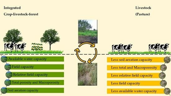
The highest calculated total porosity (TP) in the 0.00–0.10 m soil layer (0.49 m3 m−3) is attributed to the sandy texture of the surface layer of the Planosols, along with the total organic carbon content derived from organic matter accumulation and root system decomposition, particularly from Brachiaria grass. The I+SG and CC treatments in the 0.00–0.10 m layer showed statistically significant mean values (p < 0.05), with 0.40 and 0.49 m3 m−3, respectively. Treatments involving Brachiaria grass intercropping contributed to soil structure improvement by increasing soil porosity through organic matter input.
Macroporosity (Ma) in the 0.00–0.10 m layer showed a statistically significant difference (p < 0.05), with the highest mean value observed in the CC treatment (0.11 m3 m−3), exceeding the critical threshold of 0.10 m3 m−3 as defined by [33]. The lowest Ma value (0.03 m3 m−3) was found in the GL+SG treatment in the 0.00–0.10 m layer and in the BD, I+SG, and C+SG treatments in the 0.20–0.30 m subsurface layer. This result may be associated with increased Bd in the subsurface layers, which restricts root penetration and impairs plant development. Additionally, reduced porosity limits water infiltration, potentially leading to the formation of gullies and overall soil degradation [34].
Bulk density is widely used as an indicator in most soil studies due to its strong relationship with other soil attributes. It is well established that as Bd increases, there is a reduction in total porosity, macroporosity, hydraulic conductivity, and ionic absorption, along with a corresponding increase in microporosity and mechanical resistance to root penetration [35]. In pasture areas, soil compaction is primarily caused by animal load, with the bulk density increasing due to surface applied pressure.
According to [36], the TP is an important indicator of soil quality, as higher porosity reflects conditions in which the soil has not been altered by pressure from traffic or tillage. Inadequate soil use, such as excessive tillage and the absence of conservation practices, can lead to increased Bd and reduced TP and macroporosity [37]. TP tends to be higher in native forest areas than in other systems, regardless of soil depth. Reference [38] further notes that the reduction in total pore volume in pasture areas may be primarily due to a decrease in macroporosity, since microporosity does not appear to be directly influenced by soil management.
Microporosity is associated with soil texture, a pedological characteristic that can be altered by land use; however, the influence of management on this attribute is generally limited [39]. According to [40], in clayey soils, the proportion of micropores tends to be greater than that of macropores at greater depths, a pattern also observed in the present study.
Based on the threshold proposed by [18], the I+SG, NV, and CC treatments exhibited values equal to or above the recommended limit in the 0.00–0.10 m layer. It is also worth noting that the GL+SG and C+SG treatments in the 0.20–0.30 m layer showed adequate SAC values (0.14 and 0.16 m3 m−3, respectively). The remaining treatments had values below the minimum required for adequate gas diffusion in the rhizosphere zone of plants.
In the 0.00–0.10 m layer, statistically significant values (p < 0.05) were observed in the NV and CC treatments, with SAC values of 0.20 and 0.16 m3 m−3, respectively. In the 0.10–0.20 m layer, the treatments that showed significant values were C+SG, I+SG, CC, and NV. In the 0.20–0.30 m layer, significant values were observed in the C+SG, GL+SG, I+SG, CC, and NV treatments.
This observation aligns with [41], who stated that when aeration porosity is below 0.10 m3 m−3, the oxygen flux rate to the plant root system is severely restricted, negatively impacting the physiological and metabolic processes responsible for root growth and development. Furthermore, a marked increase in SAC above the critical threshold of 0.34 m3 m−3 may indicate low water retention and availability in the soil for plants [2]. However, no values exceeding 0.34 m3 m−3 were observed in this study. Regarding θRAC, statistically significant differences (p < 0.05) were observed only in the surface layer (0.00–0.10 m). The treatments that showed significant values were C+SG, SG, NV, and CC.
In addition to its many essential functions in agricultural systems, soil also acts as a reservoir for water storage for crops. The available water capacity (AWC) in the soil, which plants can absorb, is defined as the amount of water held between field capacity (θFC) and the permanent wilting point (θPWP). Studies [21,42] have shown that, in most soils and under typical conditions, soil reaches field capacity when the water matric potential (Ψm) ranges from −10 kPa (in sandy soils and Oxisols, even those with a high clay content) to −30 kPa (in clay soils). It has also been established that the matric potential corresponding to the θPWP is −1.500 kPa [21]. Moreover, according to [43], soil moisture content knowledge is crucial for making informed decisions regarding when and how much to irrigate cultivated crops.
As shown in Table 6, θFC was highest in the NV treatment in the 0.00–0.10 m layer, with a value of 0.201 m3 m−3, while the lowest value was observed in the C+SG treatment in the 0.10–0.20 m layer, with 0.107 m3 m−3. Significant differences (p < 0.05) were found across all three layers analyzed for this variable. In the 0.00–0.10 m layer, the GL+SG and NV treatments showed statistically distinct means. The NV and CC treatments differed significantly in the second layer (0.10–0.20 m). Finally, in the 0.20–0.30 m layer, the I+BD, NV, and CC treatments differed. According to [21], the soil behaves as a reservoir for plant-available water. Although this reservoir is open to the atmosphere and deeper soil profile horizons, it retains water by interacting with the soil matrix.
The permanent wilting point is generally considered a static property of the soil, unlike the field capacity [21]. For this variable, a statistically significant variation (p < 0.05) was observed across all three soil layers. In the 0.00–0.10 m and 0.10–0.20 m layers, significant differences were found in the NV and CC treatments. In the 0.20–0.30 m layer, in addition to the NV and CC treatments, the I+SG treatment also showed distinct values.
The treatments that presented the highest and lowest permanent wilting point values were NV and GL+SG. Furthermore, it was observed that the native vegetation and conventional cropping system showed statistically significant variation across all three soil layers for both the field capacity and permanent wilting point. Furthermore, for the variable plant-available water (θAW), a significant difference (p < 0.05) was observed only in the second layer (0.10–0.20 m) for the C+SG treatment. Across all treatments, mean values ranged from 0.057 to 0.097 m3 m−3, corresponding to the lowest available water content in the C+SG treatment and the highest in the NV treatment.
However, regarding the critical threshold for this parameter, ref. [34] indicates a critical range of 0.15 to 0.25 m3 m−3 for plant-available water. All treatments in this study fall well below that critical limit. Although the soil is a Planosol with a higher sand content in the surface layer, a greater degree of homogenization has been observed by the eighth year of system implementation.
When analyzing available water capacity (AWC), it was observed that only the C+SG treatment in the 0.10–0.20 m layer showed a statistically different mean value (p < 0.05), with 8.35 mm of stored water, which was also the lowest AWC value among all treatments. The highest values were recorded in the I+SG treatment in the 0.20–0.30 m layer (12.69 mm) and the NV treatment in the 0.00–0.10 m layer (12.53 mm) of stored water. This behavior is associated with better pore distribution in Integrated Crop–Livestock systems and native vegetation environments. In NV environments, water retention and availability are generally related to soil organic matter content, whereas in conventional cropping systems, soil bulk density tends to be more effective for water retention compared to SOM.
Regarding the relative field capacity (RFc), a statistically significant difference (p < 0.05) was observed across all three depths. In the 0.00–0.10 m layer, the I+SG and NV treatments showed significant mean values of 0.36 and 0.44 m3 m−3, respectively. In the 0.10–0.20 m layer, the NV and CC treatments had mean values of 0.45 and 0.40 m3 m−3, respectively. Finally, in the 0.20–0.30 m layer, only the I+SG and C+SG treatments showed significant differences, with, respectively, 0.39 and 0.29 m3 m−3 values. Although these differences were statistically significant (p < 0.05), it is evident that all values remained below the range considered ideal. According to [44], the optimal RFc should range between 0.6 ≤ RFc and ≤0.7 to ensure a proper balance between water availability and soil aeration in the root zone. Values outside this range may reduce soil microbial activity due to inefficient water or air content [17], with reference values being: <0.6 indicating low water content and >0.7 indicating low air content.
The highest values of the S-index found in the surface layers are associated with Bd and organic matter content in the soil. These layers tend to have better structure, assuming that greater porosity is present. Among the treatments analyzed for the 0.00–0.10 m layer, the highest S-index value was observed in the NV treatment, with an average of 0.25 m3 m−3, while the lowest value was 0.08 m3 m−3, found in the CC treatment in the 0.20–0.30 m layer.
Finally, it is important to highlight that after eight years of implementing the system, some treatments already show significant differences in relation to physical-hydraulic properties.

4.3. Pearson Correlation

Among the treatments evaluated, the interactions ranged from moderate to strong. In the SG treatment, one strong and one negative correlation were observed. The strong positive correlation was between the total porosity (TP) and macroporosity (Ma) (r = 0.96). However, this correlation may be influenced by the surface layers, as soil bulk density showed only weak correlations.
Because soil density is closely related to other soil attributes, it is widely used as an indicator in most research and converges on the fact that, with increasing soil density, there is a decrease in total porosity, macroporosity, hydraulic conductivity, and ionic absorption, as well as a consequent increase in microporosity and mechanical resistance to root penetration [36]. However, this behavior was not observed in the treatment in question.
In the GL+BD treatment, strong positive correlations were observed between total porosity (TP) and macroporosity (Ma) (r = 0.72) and between microporosity (Mi) and plant-available water (AW) (r = 0.75). In the I+SG and C+SG treatments, only one strong positive correlation was identified: between α and Mi, with r = 0.88 and r = 0.82, respectively. In the SB+BD treatment, no strong positive or negative correlations were observed; however, a moderate negative interaction was found between Ma and Mi (r = −0.66).
When analyzing the additional treatments, it was noted that the NV treatment did not show any strong positive correlations. However, for the variable bulk density (Bd), two strong negative correlations were observed: between Bd and TP (r = −0.71) and between Bd and plant-available water (AW) (r = −0.80).
In the CC treatment, two strong positive correlations were observed: between total porosity (TP) and macroporosity (Ma) (r = 0.78) and between TP and microporosity (Mi) (r = 0.83). A strong negative correlation in this treatment was found between soil bulk density and flocculation degree (FD) (r = −0.74). The observed data highlight that bulk density was a limiting factor for the other variables, given that a high soil density compromises macropores and micropores, total porosity, available water, hydraulic conductivity, and, consequently, the development of plant species.

5. Conclusions

After eight years of implementing the integrated production system, significant differences were observed among systems that included shrub and tree components. The SG, I+SG, SB+SG, and NV treatments showed the highest values of Bd, BdRelative, and DC in the layers below 0.10 m. The I+SG and C+SG treatments showed the lowest values of saturated hydraulic conductivity (Kθ) and macroporosity (Ma).
The SG and C+SG treatments showed the lowest plant-available water (θAW) levels and available water capacity (AWC) across all three soil layers analyzed. According to the S-index data, all treatments exhibited good soil structure quality, and the relative field capacity indicates low capacity of water retention in the soil and elevated aeration.
A longer evaluation period is necessary for more significant changes to be verified. The Crop–Livestock–Forest Integration system, over the years, tends to present improvements in the physical structure of the soil, with an increase in structural and aggregate stability, as well as in the stock and recovery rate of carbon in the soil due to the high deposition of organic matter and consequent protection of the soil, avoiding the occurrence of water destruction and stimulating the action of soil fauna, favoring the formation of a stable structure fundamental to a semiarid environment.

Author Contributions

Conceptualization, V.S.F. and F.P.d.O.; methodology, V.S.F. and F.P.d.O.; validation, V.S.F. and M.C.C.C.; formal analysis, V.S.F., A.F.M. and F.P.d.O.; investigation, V.S.F. and F.P.d.O.; resources, F.P.d.O. and M.C.C.C.; data curation, V.S.F. and T.A.F.d.S.; writing—original draft preparation, V.S.F., F.P.d.O., P.L.F.d.S. and M.C.C.C.; writing—review and editing, W.E.P., D.S., T.A.F.d.S. and M.C.C.C.; visualization, M.C.C.C. and R.V.d.S.; supervision, A.F.M. and T.A.F.d.S.; project administration, F.P.d.O.; funding acquisition, F.P.d.O. All authors have read and agreed to the published version of the manuscript.

Funding

This research was funded by the Paraíba State Research Support Foundation (FAPESQ), Grant Term No. 55472.923.31713.27102022—NOTICE No. 19/2022 SUPPORT PROGRAM FOR CENTERS IN CONSOLIDATION OF THE STATE OF PARAÍBA—Programa 22210.12.573.5011.6014, rubrica 3390.20 da Fonte 500 referring to the project entitled “Consolidation of a Crop-Livestock-Forest integration system: an alternative for sustainable production in the Agreste Paraibano”.

Data Availability Statement

The original contributions presented in the study are included in the article, further inquiries can be directed to the first author (Valter Silva Ferreira).

Conflicts of Interest

The authors declare no conflicts of interest.

References

  1. De Souza, D.C. Sistema Integração Lavoura-Pecuária-Floresta e a Neutralização dos Gases de Efeito Estufa; 31 f. TCC (Graduação em Zootecnia); Pontifícia Universidade Católica de Goiás Escola de Ciências Médicas e da Vida: Goiânia, Brazil, 2021; p. 31. [Google Scholar]
  2. da Silva, P.L.F.; de Oliveira, F.P.; Pereira, W.E.; Martins, A.F.; Zonta, J.H.; Amaral, A.J.D.; Tavares, D.D.; da Silva, A.J. Qualidade física de solo arenoso em ambiente semiárido sob sistema de integração Lavoura-Pecuária. Braz. J. Biosyst. Eng. 2021, 15, 598–616. [Google Scholar] [CrossRef]
  3. Balbino, L.C.; Cordeiro, L.A.M.; Oliveira, P.; Kluthcouski, J.; Galerani, P.R.; Vilela, L. Agricultura Sustentável por Meio da Integração Lavoura-Pecuária-Floresta; Informações Agronômicas nº 138; International Plant Nutrition Institute: Piracicaba, Brasil, 2012; 18p. [Google Scholar]
  4. Valani, G.P.; Martíni, A.F.; da Silva, L.F.S.; Bovi, R.C.; Cooper, M. Soil quality assessments in integrated crop–livestock–forest systems: A review. Soil Use Manag. 2020, 37, 22–36. [Google Scholar] [CrossRef]
  5. Peron, C.C.; Olmedo, J.P.; Dell’acqua, M.M.; Scalco, F.L.G.; Cintrão, J.F.F. Produção orgânica: Uma estratégia sustentável e competitiva para a agricultura familiar. Retratos De Assentamentos 2018, 21, 104–127. [Google Scholar] [CrossRef]
  6. Costa, L.M.D.; Drescher, M.S. Implications of agricultural management on the epigeic fauna and soil physical properties of a clayey Oxisol. Rev. Ceres 2018, 65, 443–449. [Google Scholar] [CrossRef]
  7. Kichel, A.N.; Bungenstab, D.J.; Zimmer, A.H.; Soares, C.O.; Almeida, R.G. Sistemas de integração lavoura-pecuária-floresta e o progresso do setor agropecuário brasileiro. In Sistemas de Integração Lavoura-Pecuária-Floresta; Bungenstab, D.J., Ed.; Embrapa: Brasília, Brazil, 2012; pp. 1–10. [Google Scholar]
  8. UNCCD—United Nations Convention to Combat Desertification. Regions: Africa. 2022. Available online: https://www.unccd.int/sites/default/files/2022-02/UNCCD_Convention_ENG_0.pdf (accessed on 15 November 2023).
  9. Ferreira, J.T.P.; Ribeiro, M.R.R.; Ribeiro, M.R.; Júnior, V.S.d.S.; Bittar, S.M.B.; dos Santos, R.G. Planosols Developed in Different Geoenvironmental Conditions in Northeastern Brazil. Rev. Bras. Ciênc. Solo 2016, 40, e0150131. [Google Scholar] [CrossRef]
  10. Batista, P.H.D.; de Almeida, G.L.P.; de Lima, R.P.; Pandorfi, H.; da Silva, M.V.; Rolim, M.M. Impact of short-term grazing on physical properties of Planosols in Northeastern Brazil. Geoderma Reg. 2019, 19, e00234. [Google Scholar] [CrossRef]
  11. Santos, H.G.; Jacomine, P.K.T.; Anjos, L.H.C.; Oliveira, V.Á.; Lumbreras, J.F.; Coelho, M.R.; Almeida, J.A.; Araújo Filho, J.C.; Oliveira, J.B.; Cunha, T.J.F. Sistema Brasileiro de Classificação de Solos, 5th ed.; Embrapa: Brasília, Brazil, 2018; 356p. [Google Scholar]
  12. IUSS Working Group WRB. World Reference Base for Soil Resources 2014, International Soil Classification System for Naming Soils and Creating Legends for Soil Maps; World Soil Resources Reports No. 106; FAO: Rome, Italy, 2015; Available online: http://www.fao.org/3/a-i3794e.pdf (accessed on 22 June 2025).
  13. Teixeira, P.C.; Donagemma, G.K.; Fontana, A.; Teixeira, W.G. (Eds.) Manual de Métodos de Análise de Solo, 3rd ed.; Embrapa: Brasília, Brazil, 2017; 574p, ISBN 978-85-7035-771-7. [Google Scholar]
  14. Blake, G.R.; Hartge, K.H. Bulk density. In Methods of Soil Analysis: Part 1: Physical and Mineralogical Methods, 2nd ed.; Klute, A., Ed.; Soil Science Society of America: Madison, WI, USA, 1986; pp. 363–375. [Google Scholar]
  15. Marcolin, C.D.; Klein, V.A. Determinação da densidade relativa do solo por uma função de pedotransferência para a densidade do solo máxima. Acta Sci. Agron. 2011, 33, 349–354. [Google Scholar] [CrossRef]
  16. Suzuki, L.E.A.S.; Reichert, J.M.; Reinert, D.J.; Lima, C.L.R. Grau de compactação, propriedades físicas e rendimento de culturas em Latossolo e Argissolo. Pesqui. Agropecuária Bras. 2007, 42, 1159–1167. [Google Scholar] [CrossRef]
  17. Reynolds, W.D.; Drury, C.F.; Yang, X.M.; Fox, C.A.; Tan, C.S.; Zhang, T.Q. Land management effects on the near-surface physical quality of a clay loam soil. Soil Tillage Res. 2007, 96, 316–330. [Google Scholar] [CrossRef]
  18. Carter, M.R. Temporal variability of soil macroporosity in a fine sandy loam under mouldboard ploughing and direct drilling. Soil Tillage Res. 1988, 12, 37–51. [Google Scholar] [CrossRef]
  19. Anghinoni, G.; Tormena, C.A.; Lal, R.; Zancanaro, L.; Kappes, C. Enhancing soil physical quality and cotton yields through diversification of agricultural practices in central Brazil. Land Degrad. Dev. 2019, 30, 788–798. [Google Scholar] [CrossRef]
  20. Richards, L.A. Pressure-membraneapparatus, conductionand use. Agric. Eng. 1947, 28, 451–454. [Google Scholar]
  21. Reichardt, K. Capacidade de campo. Rev. Bras. De Ciência Do Solo 1988, 12, 211–216. [Google Scholar]
  22. Richards, L.A.; Weaver, L.R. Fifteen-atmosphere percentage as related to the permanent wilting percentage. Soil Sci. 1943, 56, 331–340. [Google Scholar] [CrossRef]
  23. Bezerra, J.R.C.; Amorim Neto, M.S.; Luz, M.J.S.; Barreto, A.N.; Silva, L.C. Irrigação do algodoeiro herbáceo. In O Agronegócio do Algodão no Brasil; Embrapa Comunicação para Transferência de Tecnologia: Brasília, Brazil, 1999; pp. 619–682. [Google Scholar]
  24. Dexter, A.R. Soil Physical Quality: Part I. Theory, Effects of Soil Texture, Density, and Organic Matter, and Effects on Root Growth. Geoderma 2004, 120, 201–214. [Google Scholar] [CrossRef]
  25. R Development Core Team. R: A Language and Environment for Statistical Computing; R Foundation for Statistical Computing: Vienna, Austria, 2013. [Google Scholar]
  26. da Silva, P.L.F. Atributos Físicos e Químicos de um Planossolo Sob Sistemas de Integração Lavoura-Pecuária-Floresta no Agreste da Paraíba; 142 f. Monografia (Graduação em Agronomia); Universidade Federal da Paraíba: Areia, Brazil, 2019. [Google Scholar]
  27. Zanfolin, P.R.L.; Calonego, J.C.; Guerra, W.E.X.; Catuchi, T.A.; Francisquini Junior, A.; Godoy Junior, W.A.L. Estabilidade de agregados e grau de floculação em solos sob sistema de integração Lavoura-Pecuária com manejo físico e químico diferenciado. In Congresso Brasileiro de Ciência do Solo, 35; Anais; SBCS: Natal, Brazil, 2015; pp. 1–4. [Google Scholar]
  28. Reichert, J.M.; Norton, L.D. Surface seal micromorphology as affected by fluidized bed combustion bottom-ash. Soil Technol. 1995, 7, 303–317. [Google Scholar] [CrossRef]
  29. Hillel, D. Introduction to Soil Physics; Academic Press: New York, NY, USA, 2003; 364p. [Google Scholar]
  30. Silva, P.L.F.; Oliveira, F.P.; Amaral, A.J.; Martins, A.F.; Pereira, W.E.; Tavares, D.D.; Nóbrega, C.C. Sistemas integrados de produção agropecuária: Efeitos sobre a qualidade física de um planossolo no semiárido Brasileiro. Cienc. Del Suelo 2021, 39, 307–322. [Google Scholar]
  31. Gonçalves, A.D.M.d.A.; Libardi, P.L. Análise da determinação da condutividade hidráulica do solo pelo método do perfil instantâneo. Rev. Bras. De Ciência Do Solo 2013, 37, 1174–1184. [Google Scholar] [CrossRef]
  32. Qiao, J.; Zhu, Y.; Jia, X.; Huang, L.; Mingan, S. Estimating the spatial relationships between soil hydraulic properties and soil physical properties in the critical zone (0–100 m) on the Loess Plateau, China: A state-space modeling approach. Catena 2018, 160, 385–393. [Google Scholar] [CrossRef]
  33. Ramos, M.R.; Dedecek, R.A.; da Silva, T.R.; Freire, T.M. Atributos físicos do solo no horizonte superficial em diferentes usos. Agri-Environ. Sci. 2017, 3, 37–41. [Google Scholar] [CrossRef]
  34. Reichert, J.M.; Suzuki, L.E.A.S.; Reinert, D.J. Compactação do solo em sistemas agropecuários e florestais: Identificação, efeitos, limites críticos e mitigação. In Tópicos em Ciência do Solo, 5th ed.; Ceretta, C.A., Silva, L.S., Reichert, J.M., Eds.; Sociedade Brasileira de Ciência do Solo: Viçosa, Brazil, 2007; pp. 49–134. [Google Scholar]
  35. Soares, M.D.R.; Campos, M.C.C.; Oliveira, I.A.; Cunha, J.M.; Santos, L.A.C.; Fonseca, J.S.; de Souza, Z.M. Atributos físicos do solo em áreas sob diferentes sistemas de usos na região de Manicoré, AM. Rev. De Ciências Agrárias 2016, 59, 9–15. [Google Scholar] [CrossRef]
  36. da Rocha Lima, C.G.; Carvalho, M.d.P.; de Mello, L.M.M.; Lima, R.C. Correlação linear e espacial entre a produtividade de forragem, a porosidade total e a densidade do solo de Pereira Barreto (SP). Rev. Bras. De Ciência Do Solo 2007, 31, 1233–1244. [Google Scholar] [CrossRef]
  37. Oliveira, I.A.D.; Campos, M.C.C.; Freitas, L.D.; Soares, M.D.R. Caracterização de solos sob diferentes usos na região sul do Amazonas. Acta Amaz. 2015, 45, 1–12. [Google Scholar] [CrossRef]
  38. Giarola, N.F.B.; Tormena, C.A.; Dutra, A.C. Degradação física de um Latossolo Vermelho utilizado para produção intensiva de forragem. Rev. Bras. De Ciência Do Solo 2007, 31, 863–873. [Google Scholar] [CrossRef]
  39. Costa, C.D.O.; Alves, M.C.; Sousa, A.P. Movimento de água e porosidade dos solos de uma sub-bacia hidrográfica no Noroeste do Estado de São Paulo. Irriga 2015, 20, 304–318. [Google Scholar] [CrossRef]
  40. Vendruscolo, J.; Ribeiro, T.S.; Mesquita, F.O.; Alves, A.S.; Santos, G.A. Propriedades físicas de um Latossolo e Argissolo comparados a quatro tipos de solos na Paraíba–Brasil. Rev. Verde 2011, 6, 204–212. [Google Scholar]
  41. Stefanoski, D.C.; Santos, G.G.; Marchão, R.L.; Petter, F.A.; Pacheco, L.P. Uso e manejo do solo e seus impactos sobre a qualidade física. Rev. Bras. De Eng. Agrícola E Ambient. 2013, 17, 1301–1309. [Google Scholar] [CrossRef]
  42. Libardi, P.L. Dinâmica da Água no Solo; EDUSP: São Paulo, Brazil, 2005; 335p, ISBN 8531407567. [Google Scholar]
  43. da Matos, R.M.; Neto, J.D.; de Lima, A.S.; da Silva, P.F.; Borges, V.E.; Sobrinho, T.G. Teor de umidade por diferentes métodos em neossolo do semiárido brasileiro. Rev. Bras. De Agric. Irrig. 2017, 11, 1588–1597. [Google Scholar] [CrossRef]
  44. Olness, A.; Clapp, C.E.; Liu, R.; Palazzo, A.J. Biosolids and their effects on soil properties. In Hand Book of Soil Conditioners; Wallace, A., Terry, R.E., Eds.; Marcel Dekker: New York, NY, USA, 1998; pp. 141–165. [Google Scholar]
Figure 1. Location of the ICLF experimental area in Alagoinha, Paraiban Agreste mesoregion.
Forests 16 01261 g001
Table 1. Physical characteristics of the Planosols before the implementation of the experiment in the 0.00–0.20 m soil layer.
SandSiltClayCDWFDBdPdTPTextural Class
g kg−1%g cm−3m3 m−3
6851721433873.41.542.640.42Sandy loam
CDW = clay dispersible in water; FD = flocculation degree; Bd = bulk density; Pd = particle density; and TP = total porosity.
Table 2. Chemical characterization of the Planosols before the implementation of the experiment.
pH (H2O)PK+Na+H+ + Al3+Al+3Ca+2Mg+2SBCECTOC
(1:2.5)mg dm−3cmolc dm−3g kg−1
5.76.98194.000.034.460.002.711.174.478.879.10
SB = sum of bases; CEC = cation exchange capacity; and TOC = total organic carbon.
Table 3. Particle size distribution, clay dispersed in water (AW), flocculation degree (FD), and textural classification of Planosols under an Integrated Crop–Livestock–Forest system, native vegetation, and conventional cropping system in the Agreste region of Paraíba.
TreatmentSandSiltClayFDTextural Classification
TotalAW
g kg−1
0.00–0.10 m soil layer
SG70112917031820 aSandy loam
GL+SG68115416547718 aSandy loam
I+SG66414019645769 aSandy loam
C+SG69712917429836 aSandy loam
SB+SG72312415349682 aSandy loam
NV43527429145846 aClay loam
CC54422023648797 aSandy clay loam
0.10–0.20 m soil layer
SG67914217935804 aSandy loam
GL+SG69413816841759 aSandy loam
I+SG63315621146784 aSandy clay loam
C+SG70311618126859 aSandy loam
SB+SG68113018956705 aSandy loam
NV44824231061804 aClay loam
CC52022225877701 aSandy clay loam
0.20–0.30 m soil layer
SG67713418937804 aSandy loam
GL+SG66114219759701 aSandy loam
I+SG62015822244804 aSandy clay loam
C+SG66813020260701 aSandy clay loam
SB+SG65613520941804 aSandy clay loam
NV43724531880747 aClay loam
CC51522925677701 aSandy clay loam
Means followed by the same letters in the columns do not differ significantly according to the Tukey test (p < 0.05). Treatments: SG = Signal grass; GL+SG = Gliricidia + Signal grass; I+SG= Ipê + Signal grass; C+SG = annual crop + Signal grass; SB+SG = Sabiá + Signal grass; NV = native vegetation; and CC = conventional cropping system.
Table 4. Soil bulk density (Bd), maximum bulk density (Bdmax), relative bulk density (BdRelative), degree of soil compaction (DC), and saturated hydraulic conductivity (Kθ) in Planosols under an Integrated Crop–Livestock–Forest system, native vegetation, and conventional cropping in the Agreste region of Paraíba.
TreatmentBdBdmaxBdRetativeDCKθ
g cm−3 %cm h−1
0.00–0.10 m soil layer
SG1.38 abc1.90 a0.73 ab72.5 ab0.0362 a
GL+SG1.48 ab1.90 a0.78 a77.9 a0.0382 a
I+SG1.47 ab1.88 ab0.79 a78.6 a0.0343 a
C+SG1.50 a1.89 ab0.79 a79.1 a0.0385 a
SB+SG1.44 ab1.91 a0.75 ab75.3 ab0.0360 a
NV1.31 bc1.80 c0.72 ab72.3 ab0.0375 a
CC1.23 c1.85 bc0.66 b66.3 b0.0382 a
0.10–0.20 m soil layer
SG1.53 a1.89 a0.81 a80.8 a0.0387 a
GL+SG1.48 a1.90 a0.78 a77.6 a0.0367 a
I+SG1.48 a1.86 ab0.79 a79.0 a0.0372 a
C+SG1.48 a1.88 a0.78 a78.5 a0.0377 a
SB+SG1.45 a1.88 a0.78 a77.3 a0.0352 a
NV1.45 a1.79 c0.81 a80.8 a0.0387 a
CC1.46 a1.83 bc0.79 a79.6 a0.0395 a
0.20–0.30 m soil layer
SG1.52 a1.88 a0.81 a80.6 a0.0362 a
GL+SG1.42 a1.88 a0.76 a75.4 a0.0382 a
I+SG1.54 a1.86 a0.83 a83.3 a0.0375 a
C+SG1.53 a1.87 a0.81 a81.4 a0.0390 a
SB+SG1.39 a1.86 a0.74 a74.4 a0.0360 a
NV1.46 a1.78 b0.82 a81.9 a0.0395 a
CC1.45 a1.83 ab0.79 a79.0 a0.0390 a
Means followed by the same letters in the columns do not differ significantly according to the Tukey test (p < 0.05). Treatments: SG = Signal grass; GL+SG = Gliricidia + Signal grass; I+SG = Ipê + Signal grass; C+SG = annual crop + Signal grass; SB+SG = Sabiá + Signal grasss; NV = native vegetation; and CC = conventional cropping system.
Table 5. Estimated total porosity (ϕTP), calculated total porosity (TP), macroporosity (Ma), microporosity (Mi), soil aeration capacity (SAC), and relative aeration capacity (θRAC) in Planosols under an Integrated Crop–Livestock–Forest system, native vegetation, and conventional cropping system in the Agreste region of Paraíba.
TreatmentϕTPTPMaMiSACθRAC
m3 m−3
0.00–0.10 m soil layer
SG0.48 b0.45 ab0.07 ab0.37 a0.13 bc0.35 abc
GL+SG0.44 b0.42 ab0.06 b0.36 a0.12 c0.31 bc
I+SG0.44 b0.40 b0.04 b0.36 a0.14 bc0.31 bc
C+SG0.43 b0.42 ab0.05 b0.37 a0.11 c0.30 c
SB+SG0.46 b0.45 ab0.08 ab0.36 a0.12 bc0.33 bc
NV0.73 a0.46 ab 0.06 ab0.39 a 0.20 a0.38 ab
CC0.75 a0.49 a0.11 a0.37 a0.16 b0.41 a
0.10–0.20 m soil layer
SG0.42 b0.44 a0.05 a0.38 a0.13 cd0.29 a
GL+SG0.45 b0.42 a0.03 a0.39 a0.12 cd0.31 a
I+SG0.45 b0.43 a0.04 a0.37 a0.14 bc0.31 a
C+SG0.44 b0.41 a0.04 a0.36 a0.11 d0.31 a
SB+SG0.45 b0.41 a0.05 a0.36 a0.13 cd0.32 a
NV0.69 a0.41 a 0.04 a0.37 a 0.19 a0.32 a
CC0.70 a0.42 a0.06 a0.34 a0.17 ab0.32 a
0.20–0.30 m soil layer
SG0.43 b0.41 a0.03 a0.37 a0.12 cd0.29 a
GL+SG0.46 b0.45 a0.05 a0.39 a0.14 bcd0.33 a
I+SG0.42 b0.39 a0.03 a0.36 a0.15 abc0.28 a
C+SG0.42 b0.41 a0.03 a0.36 a0.16 d0.29 a
SB+SG0.48 b0.44 a0.07 a0.36 a0.13 cd0.34 a
NV0.69 a0.43 a 0.07 a0.36 a 0.18 a0.32 a
CC0.70 a0.41 a0.07 a0.33 a0.17 ab0.32 a
Means followed by the same letters in the columns do not differ significantly according to the Tukey test (p < 0.05). Treatments: SG = Signal grass; GL+SG = Gliricidia + Signal grass; I+SG = Ipê + Signal grass; C+SG = annual crop + Signal grass; SB+SG = Sabiá + Signal grass; NV = native vegetation; and CC = conventional cropping system.
Table 6. Field capacity (θFC), permanent wilting point (θPWP), plant-available water (θAW), available water capacity (AWC), relative field capacity (RFc), and S-index in Planosols under an Integrated Crop–Livestock–Forest system, native vegetation, and conventional cropping system in the Agreste region of Paraíba.
TreatmentθFCθPWPθAWAWC (mm)RFcS-Index
m3 m−3
0.00–0.10 m soil layer
SG0.127 bc0.061 bc0.066 b9.06 a0.29 b0.23 a
GL+SG0.116 c0.050 c0.067 b9.96 a0.28 b0.22 a
I+SG0.137 bc0.065 bc0.072 ab10.59 a0.36 ab0.22 a
C+SG0.113 b0.053 c0.060 b8.90 a0.27 b0.23 a
SB+SG0.127 bc0.058 bc0.068 ab9.84 a0.28 b0.22 a
NV0.201 a0.104 a0.097 a12.53 a 0.44 a0.25 a
CC0.155 b0.076 b0.077 a9.65 a0.32 b0.23 a
0.10–0.20 m soil layer
SG0.120 c0.059 bc0.061 ab9.23 ab0.27 c0.13 a
GL+SG0.123 c0.053 c0.071 ab10.37 ab0.29 c0.14 a
I+SG0.143 bc0.069 bc0.075 ab10.93 ab0.34 bc0.14 a
C+SG0.107 c0.051 c0.057 b8.35 b0.26 c0.13 a
SB+SG0.127 bc0.061 bc0.066 ab9.66 ab0.31 bc0.15 a
NV0.187 a0.101 a 0.085 a12.28 a 0.45 a0.13 a
CC0.164 ab0.079 b0.085 a12.28 a0.40 ab0.12 a
0.20–0.30 m soil layer
SG0.121 c0.057 c0.064 a9.66 a0.30 bc0.09 a
GL+SG0.139 bc0.056 c0.083 a11.75 a0.31 bc0.10 a
I+SG0.153 abc0.070 bc0.083 a12.69 a0.39 ab0.09 a
C+SG0.117 c0.053 c0.064 a9.76 a0.29 c0.09 a
SB+SG0.132 bc0.062 c0.070 a9.67 a0.30 bc0.09 a
NV0.179 a0.102 a 0.078 a11.30 a 0.42 a0.09 a
CC0.170 ab0.084 ab0.086 a12.43 a0.42 a0.08 a
Means followed by the same letters in the columns do not differ significantly according to the Tukey test (p < 0.05). Treatments: SG = Signal grass; GL+SG = Gliricidia + Signal grass; I+SG = Ipê + Signal grass; C+SG = annual crop + Signal grass; SB+SG = Sabiá + Signal grass; NV = native vegetation; and CC = conventional cropping system.
Table 7. Pearson correlation coefficients (r) for physical attributes in Planosols under an Integrated Crop–Livestock–Forest system, native vegetation, and conventional cropping system in the Agreste region of Paraíba.
SGBdTPMaMiKθFDAW
Bd1
TP−0.361
Ma−0.390.961
Mi−0.120.18−0.031
Kθ0.200.360.290.371
FD0.130.070.20−0.42−0.551
AW−0.440.170.100.390.46−0.751
GL+SGBdTPMaMiKθFDAW
Bd1
TP−0.241
Ma−0.240.721
Mi−0.120.40−0.331
Kθ−0.020.160.60−0.551
FD−0.230.060.24−0.220.261
AW−0.150.550.000.75−0.39−0.531
I+SGBdTPMaMiKθFDAW
Bd1
TP−0.341
Ma−0.240.421
Mi−0.180.88−0.061
Kθ0.21−0.130.04−0.151
FD−0.060.340.140.34−0.111
AW−0.250.08−0.350.230.34−0.571
C+SGBdTPMaMiKθFDAW
Bd1
TP−0.571
Ma0.020.301
Mi−0.650.82−0.271
Kθ0.52−0.260.25−0.451
FD−0.370.41−0.210.50−0.471
AW−0.170.280.330.16−0.06−0.281
SB+SGBdTPMaMiKθFDAW
Bd1
TP−0.461
Ma−0.240.491
Mi−0.230.32−0.661
Kθ−0.260.240.010.231
FD0.31−0.040.38−0.46−0.141
AW−0.420.430.040.310.50−0.631
NVBdTPMaMiKθFDAW
Bd1
TP−0.711
Ma−0.400.521
Mi−0.460.60−0.351
Kθ0.61−0.430.05−0.541
FD−0.280.36−0.130.51−0.471
AW−0.800.630.350.39−0.260.081
CCBdTPMaMiKθFDAW
Bd1
TP−0.681
Ma−0.570.781
Mi−0.540.830.301
Kθ0.31−0.26−0.01−0.311
FD−0.740.470.270.43−0.421
AW0.15−0.16−0.390.12−0.24−0.441
Bd—Soil bulk density; TP—total porosity; Ma—macroporosity; Mi—microporosity; Kθ—saturated hydraulic conductivity; FD—flocculation degree; and AW—clay dispersed in water.
Disclaimer/Publisher’s Note: The statements, opinions and data contained in all publications are solely those of the individual author(s) and contributor(s) and not of MDPI and/or the editor(s). MDPI and/or the editor(s) disclaim responsibility for any injury to people or property resulting from any ideas, methods, instructions or products referred to in the content.

