

Detection and Analysis of Forest Clear-Cutting Activities Using Sentinel-2 and Random Forest Classification: A Case Study on Chungcheongnam-do, Republic of Korea


Abstract
1. Introduction
2. Materials and Methods
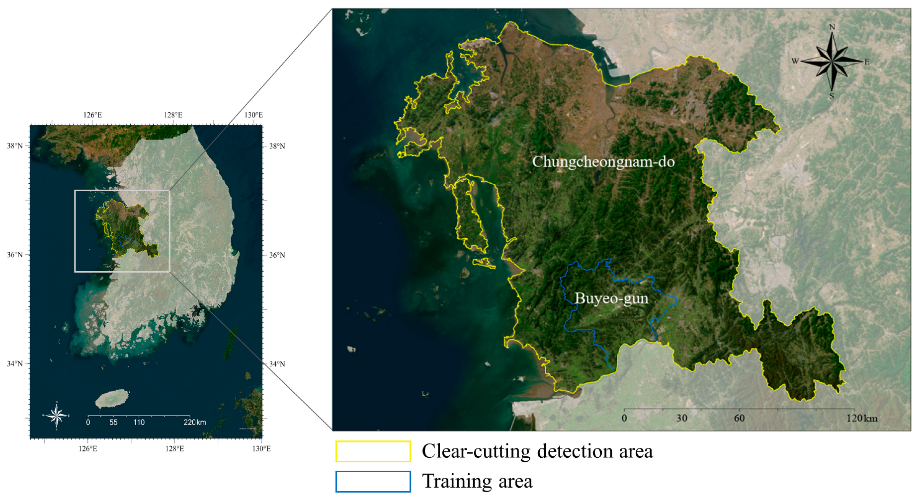
2.1. Study Area
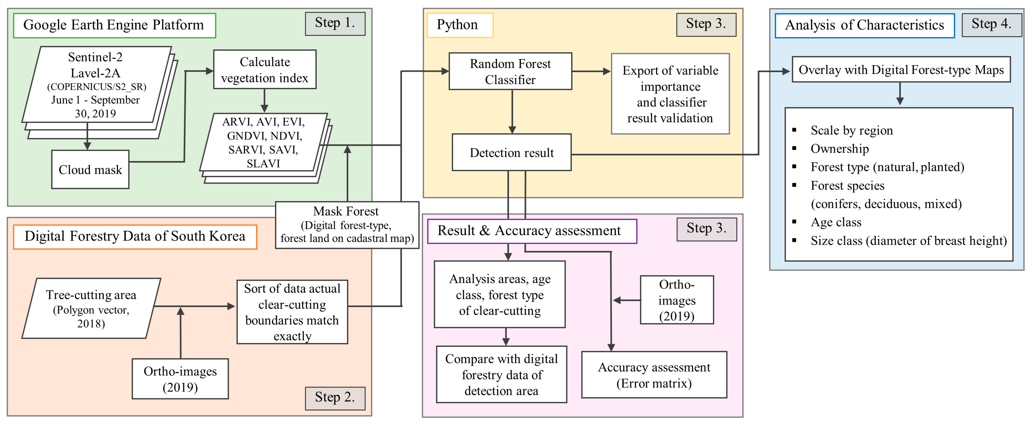
2.2. Workflow Overview
2.3. Data Collection
2.3.1. Vegetation Indices (VIs)
2.3.2. Training and Validation Dataset
2.4. Detection of Clear-Cut Areas Using Random Forest Classifier
2.5. Accuracy Assessment
2.6. Characteristics Analysis of the Clear-Cut Areas
3. Results
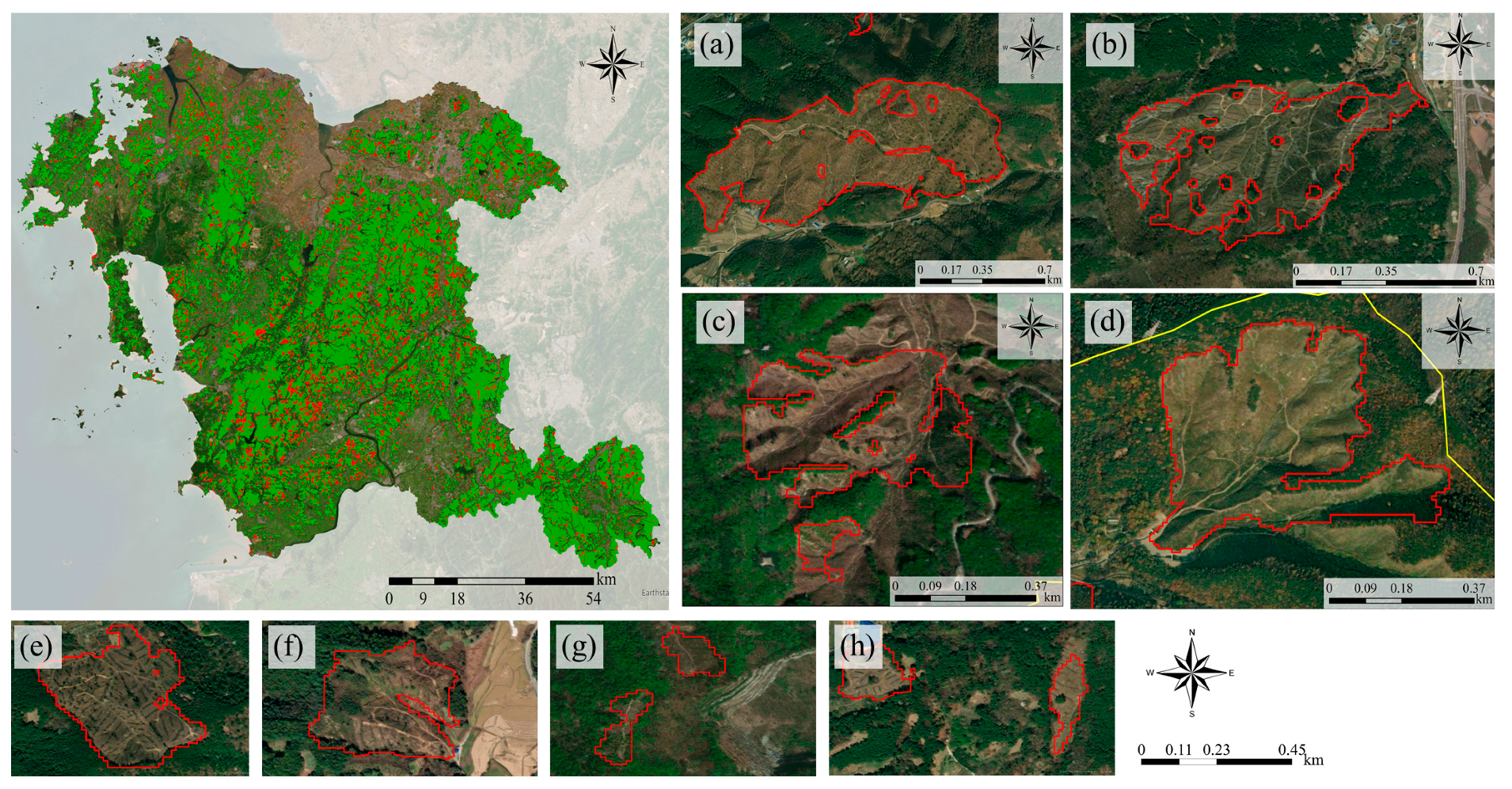
3.1. Detection of Clear-Cut Areas
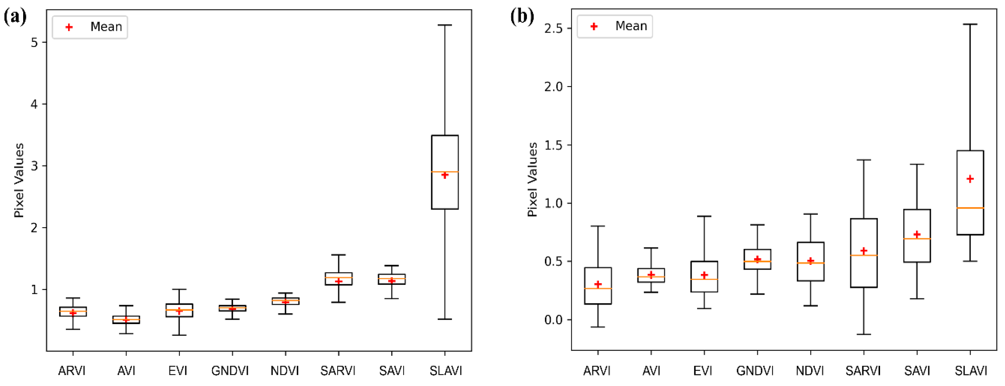
3.2. Accuracy Assessment, Variable Value, and Importance
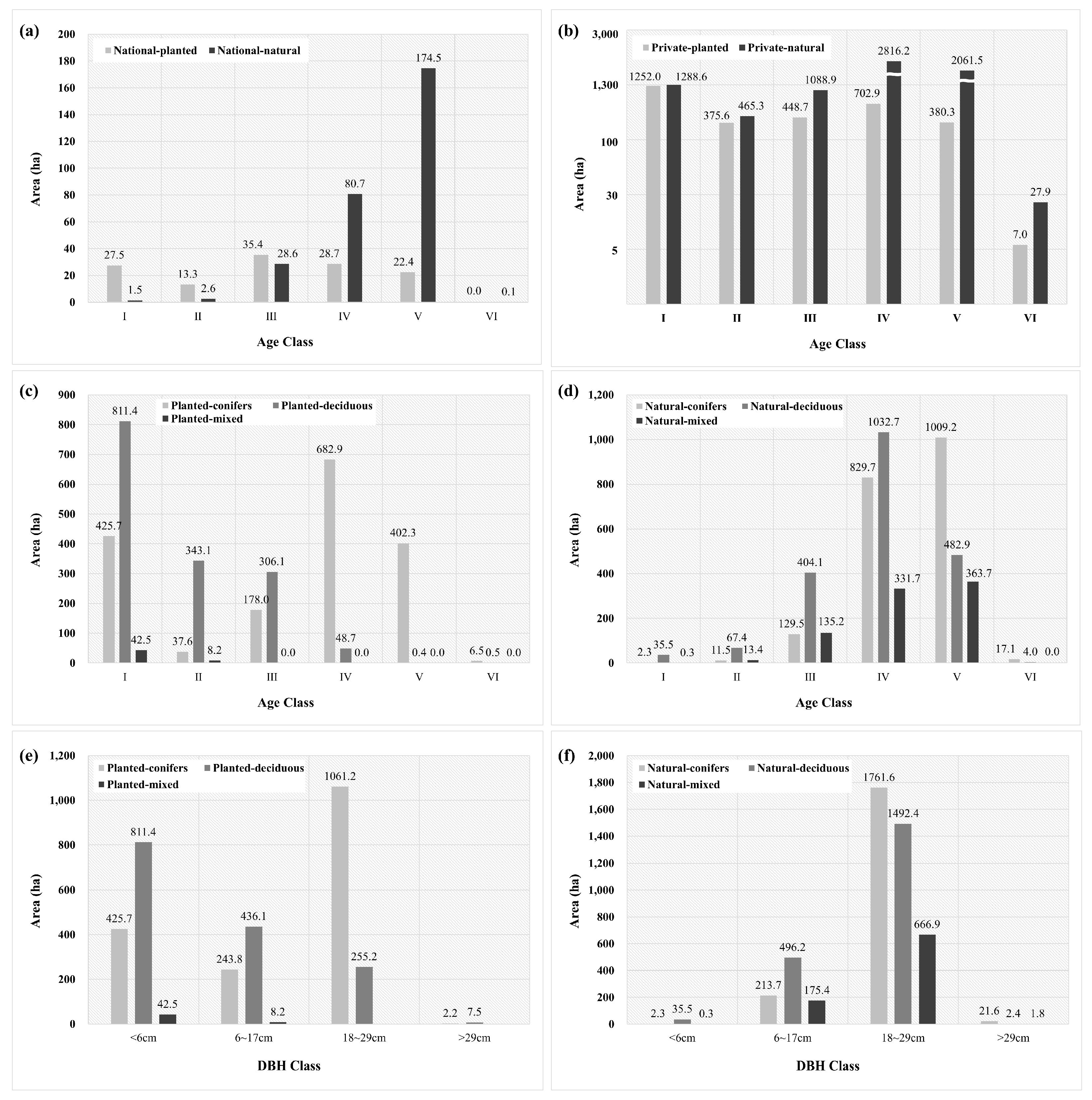
3.3. Characteristics of Clear-Cut Areas
4. Discussion
4.1. Discussion of Result
4.2. Limitation
4.3. Implications
5. Conclusions
Author Contributions
Funding
Data Availability Statement
Conflicts of Interest
References
- Potapov, P.; Yaroshenko, A.; Turubanova, S.; Dubinin, M.; Laestadius, L.; Thies, C.; Aksenov, D.; Egorov, A.; Yesipova, Y.; Glushkov, I.; et al. Mapping the World’s intact forest landscapes by remote sensing. Ecol. Soc. 2008, 13, 51. [Google Scholar] [CrossRef]
- Food and Agriculture Organization of the United Nations (FAO). Global Forest Resources Assessment 2010; Food and Agriculture Organization of the United Nations (FAO): Rome, Italy, 2010. [Google Scholar]
- Hansen, M.C.; Potapov, P.V.; Moore, R.; Hancher, M.; Turubanova, S.A.; Tyukavina, A.; Thau, D.; Stehman, S.V.; Goetz, S.J.; Loveland, T.R.; et al. High-Resolution Global Maps of 21st-Century Forest Cover Change. Science 2013, 342, 850–853. [Google Scholar] [CrossRef]
- Agrawal, A.; Hajjar, R.; Liao, C.; Rasmussen, L.V.; Watkins, C. Editorial overview: Forest governance interventions for sustainability through information, incentives, and institutions. Curr. Opin. Environ. Sustain. 2018, 32, A1–A7. [Google Scholar] [CrossRef]
- Food and Agriculture Organization of the United Nations (FAO). Global Forest Resources Assessment 2020; Food and Agriculture Organization of the United Nations (FAO): Rome, Italy, 2020. [Google Scholar]
- Olsson, H. Changes in satellite-measured reflectances caused by thinning cuttings in boreal forest. Remote Sens. Environ. 1994, 50, 221–230. [Google Scholar] [CrossRef]
- Nilson, T.; Olsson, H.; Anniste, J.; Lükk, T.; Praks, J.; Change, T.-C. Thinning-caused change in Reflectance of ground vegetation in boreal forest. Int. J. Remote Sens. 2001, 22, 2763–2776. [Google Scholar] [CrossRef]
- Bucha, T.; Stibig, H.J. Analysis of MODIS imagery for detection of clear cuts in the boreal forest in North-West Russia. Remote Sens. Environ. 2008, 112, 2416–2429. [Google Scholar] [CrossRef]
- Santoro, M.; Pantze, A.; Fransson, J.E.S.; Dahlgren, J.; Persson, A. Nation-wide clear-cut mapping in Sweden using ALOS PALSAR strip images. Remote Sens. 2012, 4, 1693–1715. [Google Scholar] [CrossRef]
- Cohen, W.B.; Healey, S.P.; Yang, Z.; Stehman, S.V.; Brewer, C.K.; Brooks, E.B.; Gorelick, N.; Huang, C.; Hughes, M.J.; Kennedy, R.E.; et al. How similar are forest disturbance maps derived from different landsat time series algorithms? Forests 2017, 8, 98. [Google Scholar] [CrossRef]
- Palaiologou, P.; Essen, M.; Hogland, J.; Kalabokidis, K. Locating forest management units using remote sensing and geostatistical tools in north-central Washington, USA. Sensors 2020, 20, 2454. [Google Scholar] [CrossRef] [PubMed]
- Chen, X.; Zhao, W.; Chen, J.; Qu, Y.; Wu, D.; Chen, X. Mapping large-scale forest disturbance types with multi-temporal CNN framework. Remote Sens. 2021, 13, 5177. [Google Scholar] [CrossRef]
- Xie, Y.; Sha, Z.; Yu, M. Remote sensing imagery in vegetation mapping: A review. J. Plant Ecol. 2008, 1, 9–23. [Google Scholar] [CrossRef]
- Wang, S.; Yang, D.; Li, Z.; Liu, L.; Huang, C.; Zhang, L. A global sensitivity analysis of commonly used satellite-derived vegetation indices for homogeneous canopies based on model simulation and random forest learning. Remote Sens. 2019, 11, 2547. [Google Scholar] [CrossRef]
- Ferchichi, A.; Ben Abbes, A.B.; Barra, V.; Farah, I.R. Forecasting vegetation indices from spatio-temporal remotely sensed data using deep learning-based approaches: A systematic literature review. Ecol. Inform. 2022, 68, 101552. [Google Scholar] [CrossRef]
- Junaid, M.; Sun, J.; Iqbal, A.; Sohail, M.; Zafar, S.; Khan, A. Mapping, LULC Dynamics and its potential implication on forest cover in malam Jabba region with landsat time series imagery and random forest classification. Sustainability 2023, 15, 1858. [Google Scholar] [CrossRef]
- Ma, T.; Hu, Y.; Wang, J.; Beckline, M.; Pang, D.; Chen, L.; Ni, X.; Li, X. A novel vegetation index approach using Sentinel-2 data and random forest algorithm for estimating forest stock volume in the Helan Mountains, Ningxia, China. Remote Sens. 2023, 15, 1853. [Google Scholar] [CrossRef]
- Potić, I.; Srdić, Z.; Vakanjac, B.; Bakrač, S.; Đorđević, D.; Banković, R.; Jovanović, J.M. Improving forest detection using machine learning and remote sensing: A Case study in Southeastern Serbia. Appl. Sci. 2023, 13, 8289. [Google Scholar] [CrossRef]
- Saini, R. Integrating vegetation indices and spectral features for vegetation mapping from multispectral satellite imagery using AdaBoost and random forest machine learning classifiers. Geomat. Environ. Eng. 2023, 17, 57–74. [Google Scholar] [CrossRef]
- Liu, J.; Feng, Q.; Gong, J.; Zhou, J.; Liang, J.; Li, Y. Winter wheat mapping using a random forest classifier combined with multi-temporal and multi-sensor data. Int. J. Digit. Earth 2018, 11, 783–802. [Google Scholar] [CrossRef]
- Adam, E.; Mutanga, O.; Odindi, J.; Abdel-Rahman, E.M. Land-use/cover classification in a heterogeneous coastal landscape using RapidEye imagery: Evaluating the performance of random forest and support vector machines classifiers. Int. J. Remote Sens. 2014, 35, 3440–3458. [Google Scholar] [CrossRef]
- Tigges, J.; Lakes, T.; Hostert, P. Urban vegetation classification: Benefits of multitemporal RapidEye satellite data. Remote Sens. Environ. 2013, 136, 66–75. [Google Scholar] [CrossRef]
- Micheletti, N.; Foresti, L.; Robert, S.; Leuenberger, M.; Pedrazzini, A.; Jaboyedoff, M.; Kanevski, M. Machine learning feature selection methods for landslide susceptibility mapping. Math. Geosci. 2014, 46, 33–57. [Google Scholar] [CrossRef]
- Saini, R.; Ghosh, S.K. Crop classification in a heterogeneous agricultural environment using ensemble classifiers and single-date Sentinel-2A imagery. Geocarto Int. 2021, 36, 2141–2159. [Google Scholar] [CrossRef]
- Stahl, A.T.; Andrus, R.; Hicke, J.A.; Hudak, A.T.; Bright, B.C.; Meddens, A.J.H. Automated attribution of forest disturbance types from remote sensing data: A synthesis. Remote Sens. Environ. 2023, 285, 113416. [Google Scholar] [CrossRef]
- Grabska, E.; Hostert, P.; Pflugmacher, D.; Ostapowicz, K. Forest stand species mapping using the Sentinel-2 time series. Remote Sens. 2019, 11, 1197. [Google Scholar] [CrossRef]
- Nasiri, V.; Hawryło, P.; Janiec, P.; Socha, J. Comparing Object-Based and Pixel-Based Machine Learning Models for Tree-Cutting Detection with Planetscope Satellite Images: Exploring Model Generalization. Int. J. Appl. Earth Obs. Geoinf. 2023, 125, 103555. [Google Scholar] [CrossRef]
- Abdollahnejad, A.; Panagiotidis, D.; Bílek, L. An Integrated GIS and Remote Sensing Approach for Monitoring Harvested Areas from Very High-Resolution, Low-Cost Satellite Images. Remote Sens. 2019, 11, 2539. [Google Scholar] [CrossRef]
- Korea Forest Service (KFS). Basic Statistics of Forest; Korea Forest Service (KFS): Deajeon, Republic of Korea, 2023. [Google Scholar]
- Ministry of Land Infrastructure and Transport (MLIT). Cadastral Statistical Annual Report; Ministry of Land Infrastructure and Transport (MLIT): Sejong, Republic of Korea, 2021. [Google Scholar]
- Xue, J.; Su, B. Significant remote sensing vegetation indices: A review of developments and applications. J. Sens. 2017, 2017, 1353691. [Google Scholar] [CrossRef]
- Hatfield, J.L.; Prueger, J.H.; Sauer, T.J.; Dold, C.; O’Brien, P.; Wacha, K. Applications of vegetative indices from remote sensing to agriculture: Past and future. Inventions 2019, 4, 71. [Google Scholar] [CrossRef]
- Huete, A.R. A soil-adjusted vegetation index (SAVI). Remote Sens. Environ. 1988, 25, 295–309. [Google Scholar] [CrossRef]
- Kaufman, Y.J.; Tanre, D. Atmospherically resistant vegetation index (ARVI) for EOS-MODIS. IEEE Trans. Geosci. Remote Sens. 1992, 30, 261–270. [Google Scholar] [CrossRef]
- Huete, A.R.; Didan, K.; van Leeuwen, W.J.D.; Vermote, E.F. Global-scale analysis of vegetation indices for moderate resolution monitoring of terrestrial vegetation. Remote Sens. Earth Sci. Ocean. Sea Ice Appl. 1999, 3863, 141–151. [Google Scholar] [CrossRef]
- Rikimaru, A.; Roy, P.S.; Miyatake, S. Tropical forest cover density mapping. Trop. Ecol. 2002, 43, 39–47. [Google Scholar]
- Hu, Y.; Dong, Y.; Batunacun, B. An automatic approach for land-change detection and land updates based on integrated NDVI timing analysis and the CVAPS method with GEE support. ISPRS J. Photogramm. 2018, 146, 347–359. [Google Scholar] [CrossRef]
- Gitelson, A.A.; Kaufman, Y.J.; Merzlyak, M.N. Use of a green channel in remote sensing of global vegetation from EOS-MODIS. Remote Sens. Environ. 1996, 58, 289–298. [Google Scholar] [CrossRef]
- Pettorelli, N.; Vik, J.O.; Mysterud, A.; Gaillard, J.M.; Tucker, C.J.; Stenseth, N.C. Using the satellite-derived NDVI to assess ecological responses to environmental change. Trends Ecol. Evol. 2005, 20, 503–510. [Google Scholar] [CrossRef]
- Lymburner, L.; Beggs, P.J.; Jacobson, C.R. Estimation of canopy-average surface-specific leaf area using landsat TM data. Photogramm. Eng. Remote Sens. 2000, 66, 183–192. [Google Scholar]
- Korea Forest Service (KFS). Statistical Yearbook of Forestry; Korea Forest Service (KFS): Deajeon, Republic of Korea, 2020. [Google Scholar]
- Ham, B.; Song, C.; Park, E.; Choi, S.-E.; Lee, W.-K. Development of forest activity data and forest management rate for national greenhouse gas inventory in the forest sector. J. Clim. Chang. Res. 2020, 11, 53–63. [Google Scholar] [CrossRef]
- Kim, D.; Lim, C.H.; Lee, W.-K.; Song, C. A study on the improvement of evaluation system for implementation of national forest management. J. Korean For. Soc. 2015, 104, 640–648. [Google Scholar] [CrossRef]
- Millard, K.; Richardson, M. On the importance of training data sample selection in random forest image classification: A case study in peatland ecosystem mapping. Remote Sens. 2015, 7, 8489–8515. [Google Scholar] [CrossRef]
- Wibowo, A.; Salleh, K.O.; Frans, F.T.R.S.; Semedi, J.M. Spatial temporal land use change detection using google earth data. IOP Conf. Ser. Earth Environ. Sci. 2016, 47, 012031. [Google Scholar] [CrossRef]
- Rwanga, S.S.; Ndambuki, J.M. Accuracy assessment of land use/land cover classification using remote sensing and GIS. Int. J. Geosci. 2017, 08, 611–622. [Google Scholar] [CrossRef]
- Ayala-Izurieta, J.E.; Márquez, C.O.; García, V.J.; Recalde-Moreno, C.G.; Rodríguez-Llerena, M.V.; Damián-Carrión, D.A. Land cover classification in an Ecuadorian mountain geosystem using a random forest classifier, spectral vegetation indices, and ancillary geographic data. Geosciences 2017, 7, 34. [Google Scholar] [CrossRef]
- Ehsan, S.; Kazem, D. Analysis of land use-land covers changes using Normalized Difference Vegetation Index (NDVI) differencing and classification methods. Afr. J. Agric. Res. 2013, 8, 4614–4622. [Google Scholar] [CrossRef]
- Da Silva, V.S.; Salami, G.; da Silva, M.I.O.; Silva, E.A.; Monteiro Junior, J.J.; Alba, E. Methodological evaluation of vegetation indexes in land use and land cover (LULC) classification. Geol. Ecol. Landsc. 2020, 4, 159–169. [Google Scholar] [CrossRef]
- Shishir, S.; Tsuyuzaki, S. Hierarchical classification of land use types using multiple vegetation indices to measure the effects of urbanization. Environ. Monit. Assess. 2018, 190, 342. [Google Scholar] [CrossRef] [PubMed]
- Maschler, J.; Atzberger, C.; Immitzer, M. Individual tree crown segmentation and classification of 13 tree species using airborne hyperspectral data. Remote Sens. 2018, 10, 1218. [Google Scholar] [CrossRef]
- Immitzer, M.; Neuwirth, M.; Böck, S.; Brenner, H.; Vuolo, F.; Atzberger, C. Optimal input features for tree species classification in Central Europe based on multi-temporal Sentinel-2 data. Remote Sens. 2019, 11, 2599. [Google Scholar] [CrossRef]
- Morcillo-Pallarés, P.; Rivera-Caicedo, J.P.; Belda, S.; De Grave, C.; Burriel, H.; Moreno, J.; Verrelst, J. Quantifying the robustness of vegetation indices through global sensitivity analysis of homogeneous and forest leaf-canopy radiative transfer models. Remote Sens. 2019, 11, 2418. [Google Scholar] [CrossRef]
- Trier, Ø.D.; Salberg, A.B.; Kermit, M.; Rudjord, Ø.; Gobakken, T.; Næsset, E.; Aarsten, D. Tree species classification in Norway from airborne hyperspectral and airborne laser scanning data. Eur. J. Remote Sens. 2018, 51, 336–351. [Google Scholar] [CrossRef]
- Bolyn, C.; Michez, A.; Gaucher, P.; Lejeune, P.; Bonnet, S. Forest mapping and species composition using supervised per pixel classification of Sentinel-2 imagery. Biotechnol. Agron. Soc. Environ. 2018, 22, 172–187. [Google Scholar] [CrossRef]
- Boonprong, S.; Cao, C.; Chen, W.; Bao, S. Random forest variable importance spectral indices scheme for burnt forest recovery monitoring—Multilevel RF-VIMP. Remote Sens. 2018, 10, 807. [Google Scholar] [CrossRef]
- Khelifi, L.; Mignotte, M. Deep learning for change detection in remote sensing images: Comprehensive review and meta-analysis. IEEE Access 2020, 8, 126385–126400. [Google Scholar] [CrossRef]
- Talukdar, S.; Singha, P.; Mahato, S.; Shahfahad; Pal, S.; Liou, Y.A.; Rahman, A. Land-Use Land-Cover Classification by Machine Learning Classifiers for Satellite Observations—A Review. Remote Sens. 2020, 12, 1135. [Google Scholar] [CrossRef]
- Wilson, E.H.; Sader, S.A. Detection of forest harvest type using multiple dates of landsat TM imagery. Remote Sens. Environ. 2002, 80, 385–396. [Google Scholar] [CrossRef]
- Franklin, S.E.; Moskal, L.M.; Lavigne, M.B.; Pugh, K. Interpretation and classification of partially harvested forest stands in the fundy model forest using multitemporal landsat TM digital data. Can. J. Remote Sens. 2000, 26, 318–333. [Google Scholar] [CrossRef]
- Brooks, E.B.; Wynne, R.H.; Thomas, V.A.; Blinn, C.E.; Coulston, J.W. On-the-fly massively multitemporal change detection using statistical quality control charts and landsat data. IEEE Trans. Geosci. Remote Sens. 2014, 52, 3316–3332. [Google Scholar] [CrossRef]
- Alonso, L.; Picos, J.; Armesto, J. Forest land cover mapping at a regional scale using multi-temporal Sentinel-2 imagery and RF models. Remote Sens. 2021, 13, 2237. [Google Scholar] [CrossRef]
- Nink, S.; Hill, J.; Stoffels, J.; Buddenbaum, H.; Frantz, D.; Langshausen, J. Using landsat and Sentinel-2 data for the generation of continuously updated forest type information layers in a cross-border region. Remote Sens. 2019, 11, 2337. [Google Scholar] [CrossRef]
- Salgueiro Romero, L.S.; Marcello, J.; Vilaplana, V. Super-resolution of Sentinel-2 imagery using generative adversarial networks. Remote Sens. 2020, 12, 2424. [Google Scholar] [CrossRef]
- Feng, Q.; Liu, J.; Gong, J. UAV Remote Sensing for Urban Vegetation Mapping Using Random Forest and Texture Analysis. Remote Sens. 2015, 7, 1074–1094. [Google Scholar] [CrossRef]


| Data | Description | Source | Data Type | Year |
|---|---|---|---|---|
| Digital Forest-type Maps (scale: 1:5000) | Republic of Korea’s forest information constructed from digitizing orthoimages | Forest Geospatial Information System (http://fgis.forest.go.kr, accessed on 3 December 2023) | Vector | 2018 |
| Forest land category in Cadastral Maps | Map dividing the national land into 28 categories, according to land use and status | National Spatial Infrastructure Portal (https://www.vworld.kr/dtna/dtna_guide_s001.do, accessed on 3 December 2023) | Vector | 2018 |
| (Unit: ha) | |||||
|---|---|---|---|---|---|
| Division | Conifer | Deciduous | Mixed | Total | |
| National Forests | Planted | 5487 | 1903 | 87 | 7476 |
| Natural | 8789 | 18,356 | 5622 | 32,767 | |
| Subtotal | 14,276 | 20,259 | 5708 | 40,243 | |
| Private Forests | Planted | 51,333 | 33,572 | 1610 | 86,515 |
| Natural | 70,341 | 98,128 | 33,813 | 202,284 | |
| Subtotal | 121,674 | 131,700 | 35,423 | 288,798 | |
| Total | 135,950 | 151,960 | 41,132 | 329,042 | |
| Vegetation Indices | Remarks | Formula | References |
|---|---|---|---|
| Atmospherically Resistant Vegetation Index (ARVI) | Minimizes the impact of atmospheric scattering from aerosols | [36] | |
| Advanced Vegetation Index (AVI) | Provides vegetation cover by using the infrared spectral band to sensitively assess vegetation density | [36] | |
| Enhanced Vegetation Index (EVI) | Corrects for atmospheric effects and soil background | [37] | |
| Green Normalized Difference Vegetation Index (GNDVI) | More sensitive to changes in chlorophyll content than NDVI | [38] | |
| Normalized Difference Vegetation Index (NDVI) | Presents vegetation cover ratio and vegetation characteristics such as biomass and chlorophyll content | [39] | |
| Soil and Atmospherically Resistant Vegetation Index (SARVI) | Minimizes the effect of atmospheric aerosols and reduces the influence of soil | [34] | |
| Soil-Adjusted Vegetation Index (SAVI) | Minimizes spectral reflection variations based on soil types | [35] | |
| Specific Leaf Area Vegetation Index (SLAVI) | Estimates the leaf area ratio within a forest | [40] |
| (Unit: ha) | ||||||
|---|---|---|---|---|---|---|
| Region | <1ha | 1~4 ha | 5~9 ha | 10~29 ha | 30~60 ha | Total |
| Asan-si | 64 | 188 | 103 | 11 | - | 366 |
| Boryeong-si | 102 | 400 | 173 | 67 | - | 742 |
| Buyeo-gun | 224 | 580 | 173 | 314 | - | 1291 |
| Cheongyang-gun | 130 | 412 | 234 | 89 | 119 | 984 |
| Dangjin-si | 94 | 239 | 47 | 50 | - | 431 |
| Cheonan-si | 97 | 341 | 123 | 132 | - | 692 |
| Geumsan-gun | 56 | 185 | 120 | 84 | - | 444 |
| Gongju-si | 208 | 578 | 315 | 283 | 85 | 1470 |
| Gyeryong-si | 18 | 14 | 14 | - | - | 46 |
| Hongseong-gun | 76 | 206 | 39 | 22 | - | 344 |
| Nonsan-si | 62 | 154 | 77 | 45 | - | 339 |
| Seocheon-gun | 55 | 155 | 7 | 25 | - | 241 |
| Seosan-si | 53 | 148 | 72 | 19 | 32 | 325 |
| Taean-gun | 50 | 64 | 30 | - | - | 145 |
| Yesan-gun | 63 | 142 | 50 | 48 | - | 304 |
| Total | 1354 | 3806 | 1577 | 1190 | 237 | 8164 |
| Variables | Importance |
|---|---|
| SLAVI | 0.261940 |
| SARVI | 0.193277 |
| NDVI | 0.171838 |
| ARVI | 0.136113 |
| SAVI | 0.079224 |
| GNDVI | 0.064720 |
| EVI | 0.049265 |
| AVI | 0.043622 |
| (Unit: %) | ||||||||
|---|---|---|---|---|---|---|---|---|
| Division | Ⅰ | Ⅱ | Ⅲ | Ⅳ | Ⅴ | Ⅵ | Ratio to Total Area | |
| Planted | National forest | 0.1 | 0.1 | 0.2 | 0.1 | 0.2 | 0.0 | 0.1 |
| Private forest | 4.2 | 3.3 | 2.8 | 2.8 | 3.3 | 4.4 | 3.4 | |
| Total | 4.3 | 3.5 | 3.0 | 2.9 | 3.5 | 4.4 | 3.5 | |
| Natural | National forest | 0.1 | 0.0 | 0.1 | 0.1 | 0.2 | 0.0 | 0.1 |
| Private forest | 2.0 | 1.7 | 1.9 | 1.8 | 2.3 | 0.7 | 1.9 | |
| Total | 2.1 | 1.7 | 2.0 | 1.9 | 2.5 | 0.8 | 2.1 | |
| (Unit: %) | ||||||||
|---|---|---|---|---|---|---|---|---|
| Division | Ⅰ | Ⅱ | Ⅲ | Ⅳ | Ⅴ | Ⅵ | Ratio to Total Area | |
| Planted | Coniferous | 1.4 | 0.3 | 1.1 | 2.7 | 3.5 | 4.0 | 1.8 |
| Deciduous | 2.7 | 3.1 | 1.9 | 0.2 | 0.0 | 0.3 | 1.6 | |
| Mixed | 0.1 | 0.1 | 0.0 | 0.0 | 0.0 | 0.0 | 0.1 | |
| Total | 4.3 | 3.5 | 3.0 | 2.9 | 3.5 | 4.4 | 3.5 | |
| Natural | Coniferous | 0.1 | 0.2 | 0.4 | 0.7 | 1.4 | 0.6 | 0.9 |
| Deciduous | 1.9 | 1.2 | 1.2 | 0.9 | 0.7 | 0.1 | 0.9 | |
| Mixed | 0.0 | 0.2 | 0.4 | 0.3 | 0.5 | 0.0 | 0.4 | |
| Total | 2.1 | 1.7 | 2.0 | 1.9 | 2.5 | 0.8 | 2.1 | |
| (Unit: %) | ||||||
|---|---|---|---|---|---|---|
| Division | <6 cm | 6~17 cm | 18~29 cm | >29 cm | Ratio to Total Area | |
| Planted | Coniferous | 1.3 | 0.9 | 2.5 | 0.7 | 1.7 |
| Deciduous | 2.6 | 1.6 | 0.6 | 2.4 | 1.5 | |
| Mixed | 0.1 | 0.0 | 0.0 | 0.0 | 0.1 | |
| Total | 4.1 | 2.5 | 3.1 | 3.2 | 3.3 | |
| Natural | Coniferous | 0.1 | 0.4 | 0.9 | 0.9 | 0.8 |
| Deciduous | 2.3 | 1.0 | 0.8 | 0.1 | 0.8 | |
| Mixed | 0.0 | 0.3 | 0.3 | 0.1 | 0.3 | |
| Total | 2.4 | 1.8 | 2.0 | 1.1 | 2.0 | |
Disclaimer/Publisher’s Note: The statements, opinions and data contained in all publications are solely those of the individual author(s) and contributor(s) and not of MDPI and/or the editor(s). MDPI and/or the editor(s) disclaim responsibility for any injury to people or property resulting from any ideas, methods, instructions or products referred to in the content. |
© 2024 by the authors. Licensee MDPI, Basel, Switzerland. This article is an open access article distributed under the terms and conditions of the Creative Commons Attribution (CC BY) license (https://creativecommons.org/licenses/by/4.0/).
Share and Cite
Choi, S.-E.; Lee, S.; Park, J.; Lee, S.; Yim, J.; Kang, J. Detection and Analysis of Forest Clear-Cutting Activities Using Sentinel-2 and Random Forest Classification: A Case Study on Chungcheongnam-do, Republic of Korea. Forests 2024, 15, 450. https://doi.org/10.3390/f15030450
Choi S-E, Lee S, Park J, Lee S, Yim J, Kang J. Detection and Analysis of Forest Clear-Cutting Activities Using Sentinel-2 and Random Forest Classification: A Case Study on Chungcheongnam-do, Republic of Korea. Forests. 2024; 15(3):450. https://doi.org/10.3390/f15030450
Chicago/Turabian StyleChoi, Sol-E, Sunjeoung Lee, Jeongmook Park, Suyeon Lee, Jongsu Yim, and Jintaek Kang. 2024. "Detection and Analysis of Forest Clear-Cutting Activities Using Sentinel-2 and Random Forest Classification: A Case Study on Chungcheongnam-do, Republic of Korea" Forests 15, no. 3: 450. https://doi.org/10.3390/f15030450
APA StyleChoi, S.-E., Lee, S., Park, J., Lee, S., Yim, J., & Kang, J. (2024). Detection and Analysis of Forest Clear-Cutting Activities Using Sentinel-2 and Random Forest Classification: A Case Study on Chungcheongnam-do, Republic of Korea. Forests, 15(3), 450. https://doi.org/10.3390/f15030450