Article

Evaluation of NASA’s GEDI Lidar Observations for Estimating Biomass in Temperate and Tropical Forests


1
Beijing Engineering Research Center for Global Land Remote Sensing Products, Institute of Remote Sensing Science and Engineering, Faculty of Geographical Science, Beijing Normal University, Beijing 100875, China
2
College of Urban and Environmental Sciences, Tianjin Normal University, Tianjin 300387, China
3
School of Environment and Natural Resources, The Ohio State University, Wooster, OH 43210, USA
4
Universidad de Alcalá, Department of Geology, Geography and Environment, Environmental Remote Sensing Research Group, Colegios 2, 28801 Alcalá de Henares, Spain
5
Department of Geological and Atmospheric Sciences, Iowa State University, Ames, IA 50011, USA
6
School of Forest, Fisheries, and Geomatics Sciences, University of Florida, Gainesville, FL 32611, USA
*
Author to whom correspondence should be addressed.
Forests 2022, 13(10), 1686; https://doi.org/10.3390/f13101686
Submission received: 8 September 2022 / Revised: 7 October 2022 / Accepted: 8 October 2022 / Published: 13 October 2022
(This article belongs to the Special Issue New Insights into Remote Sensing of Vegetation Structural Parameters)

Abstract

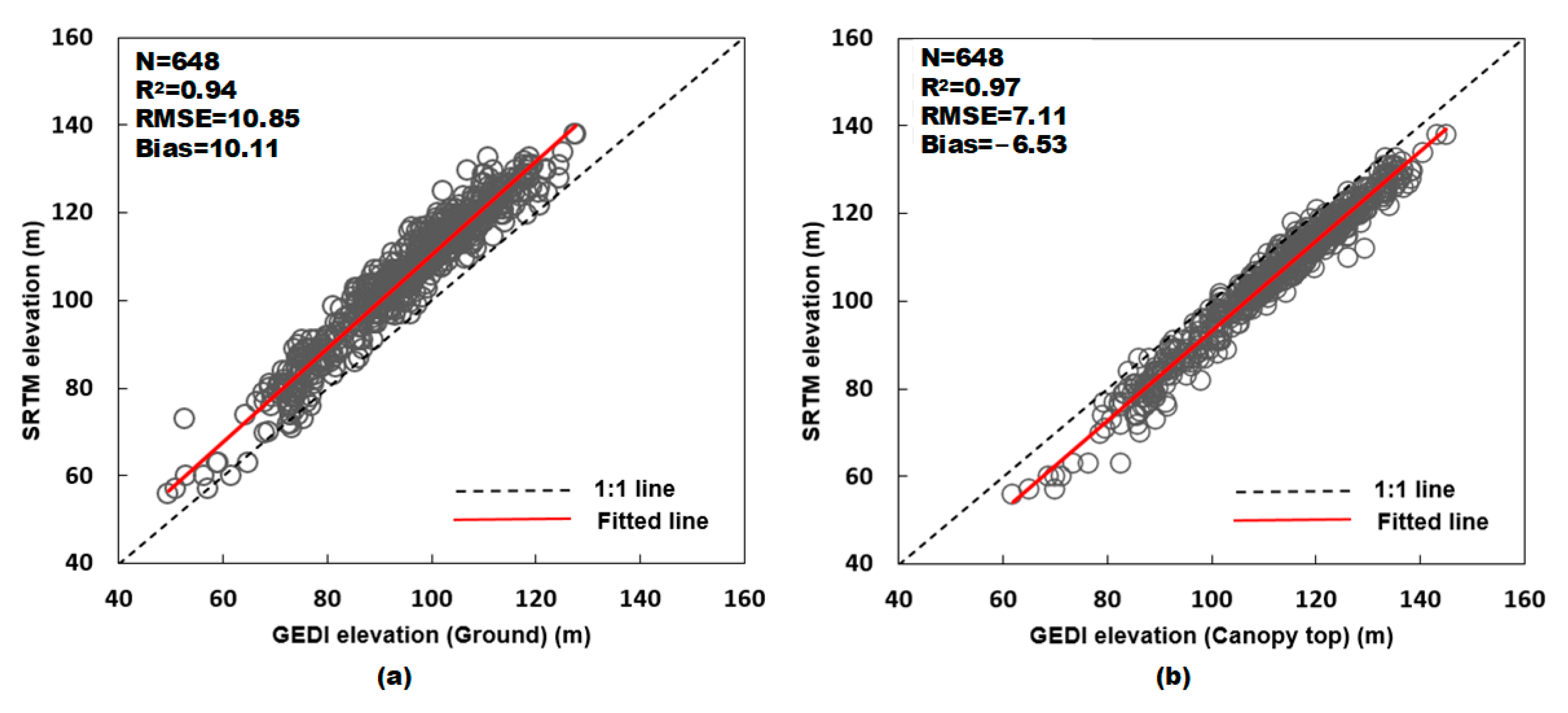
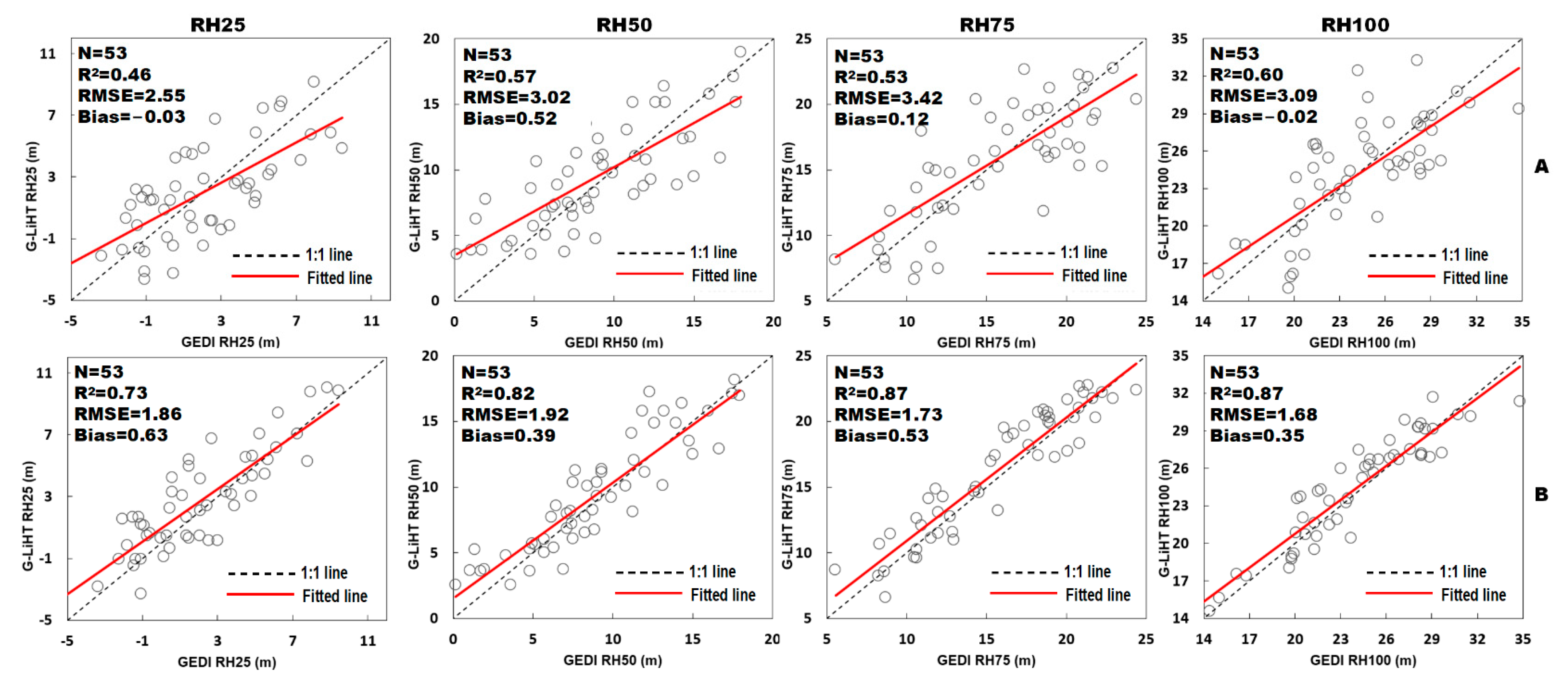
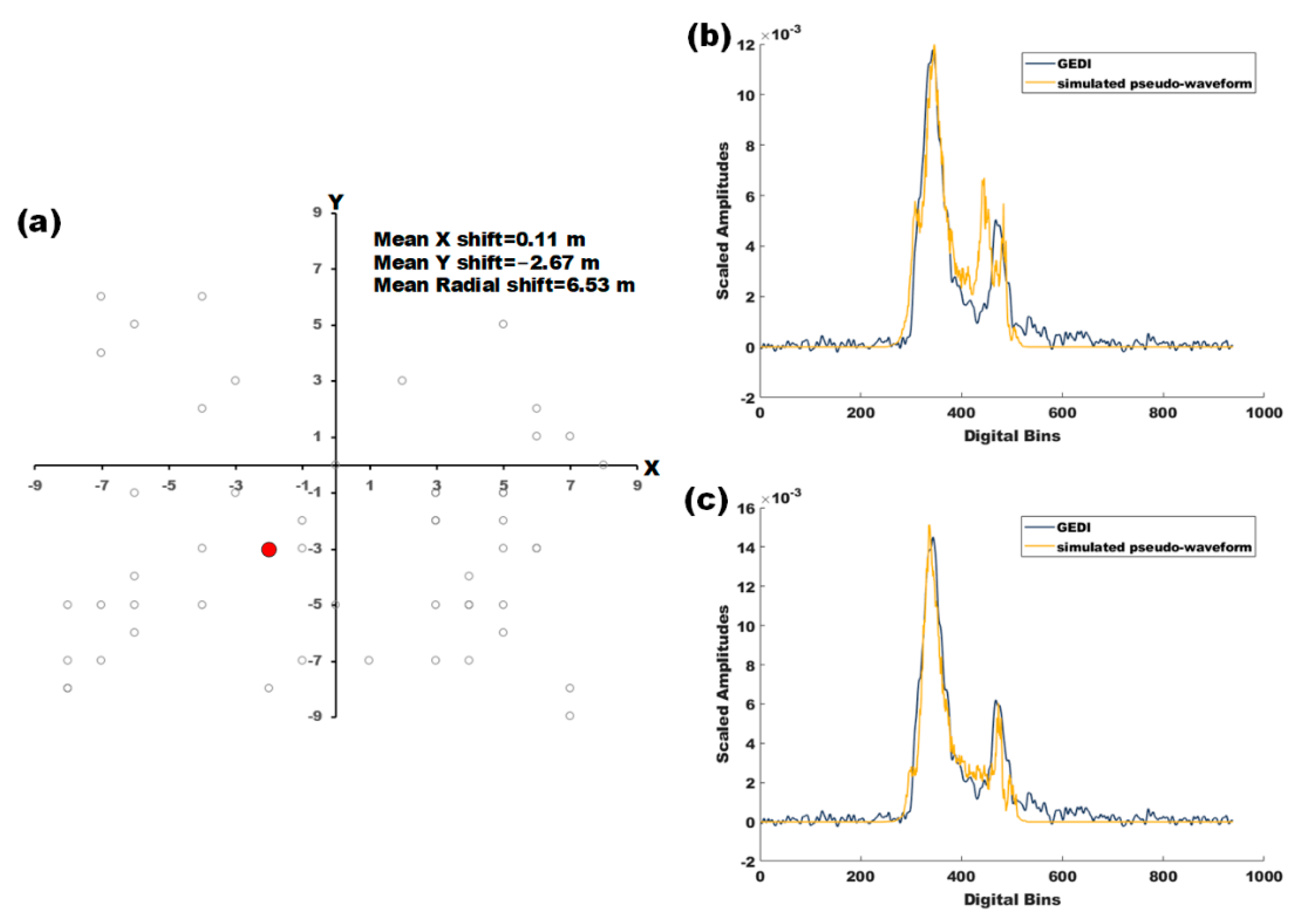
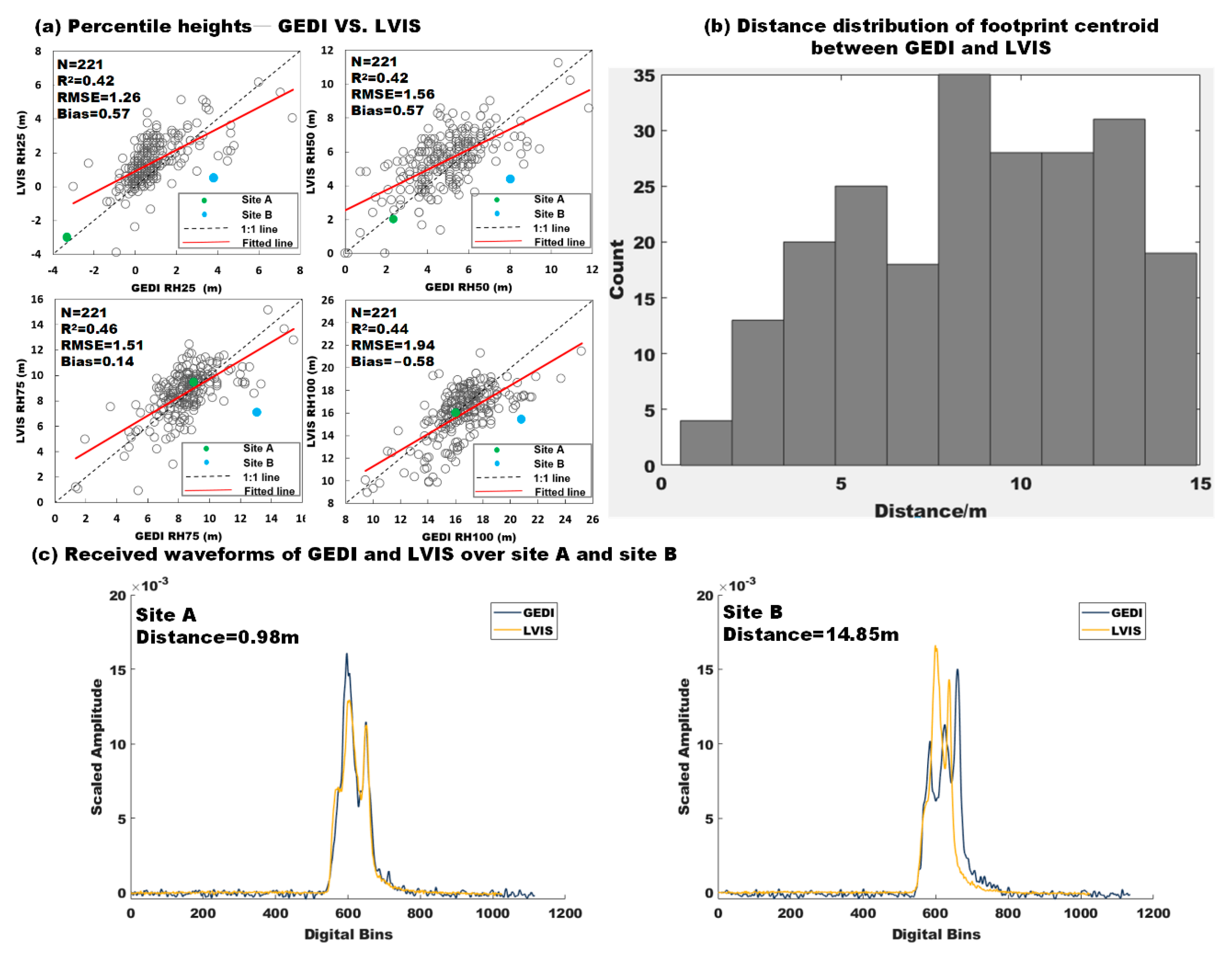
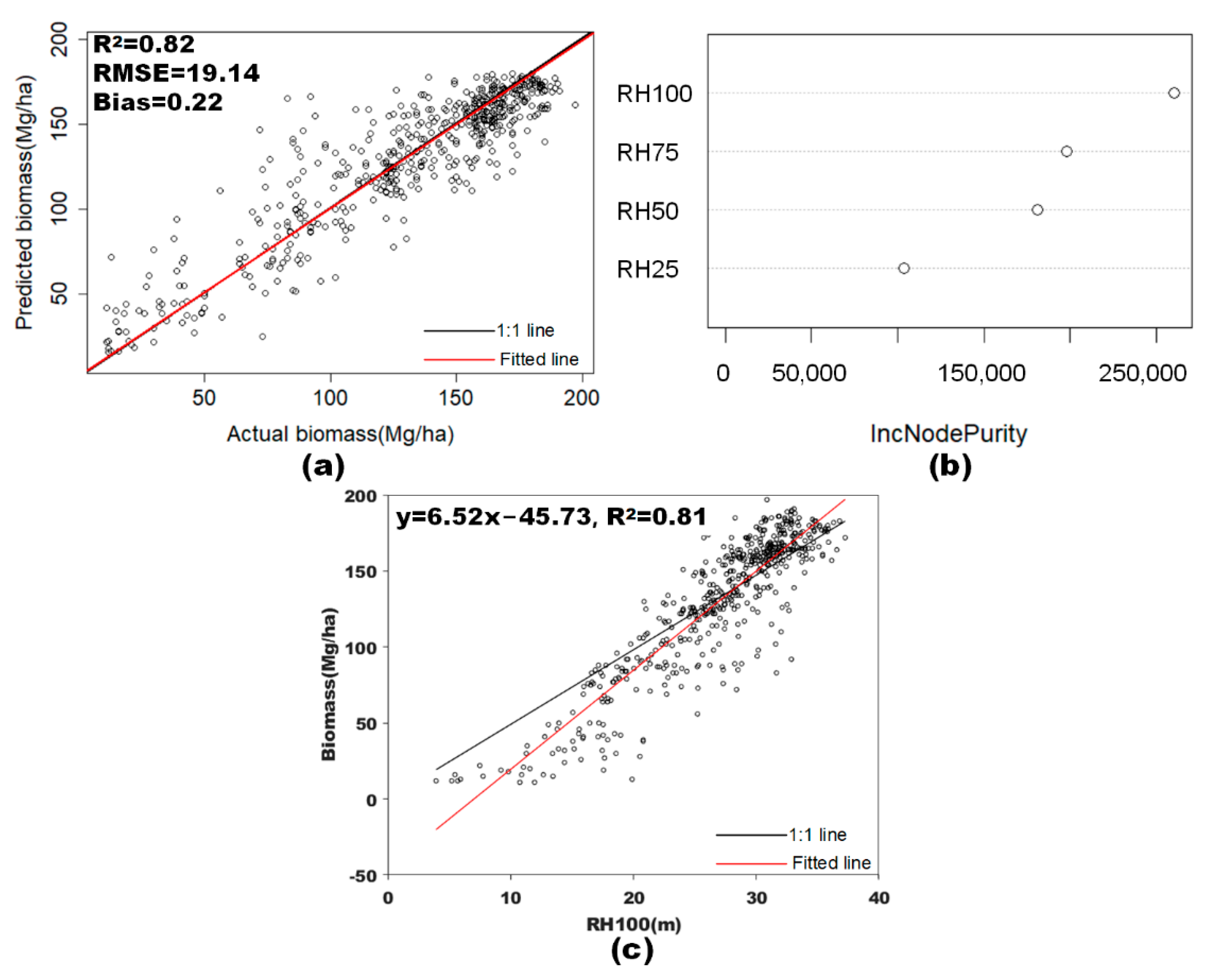
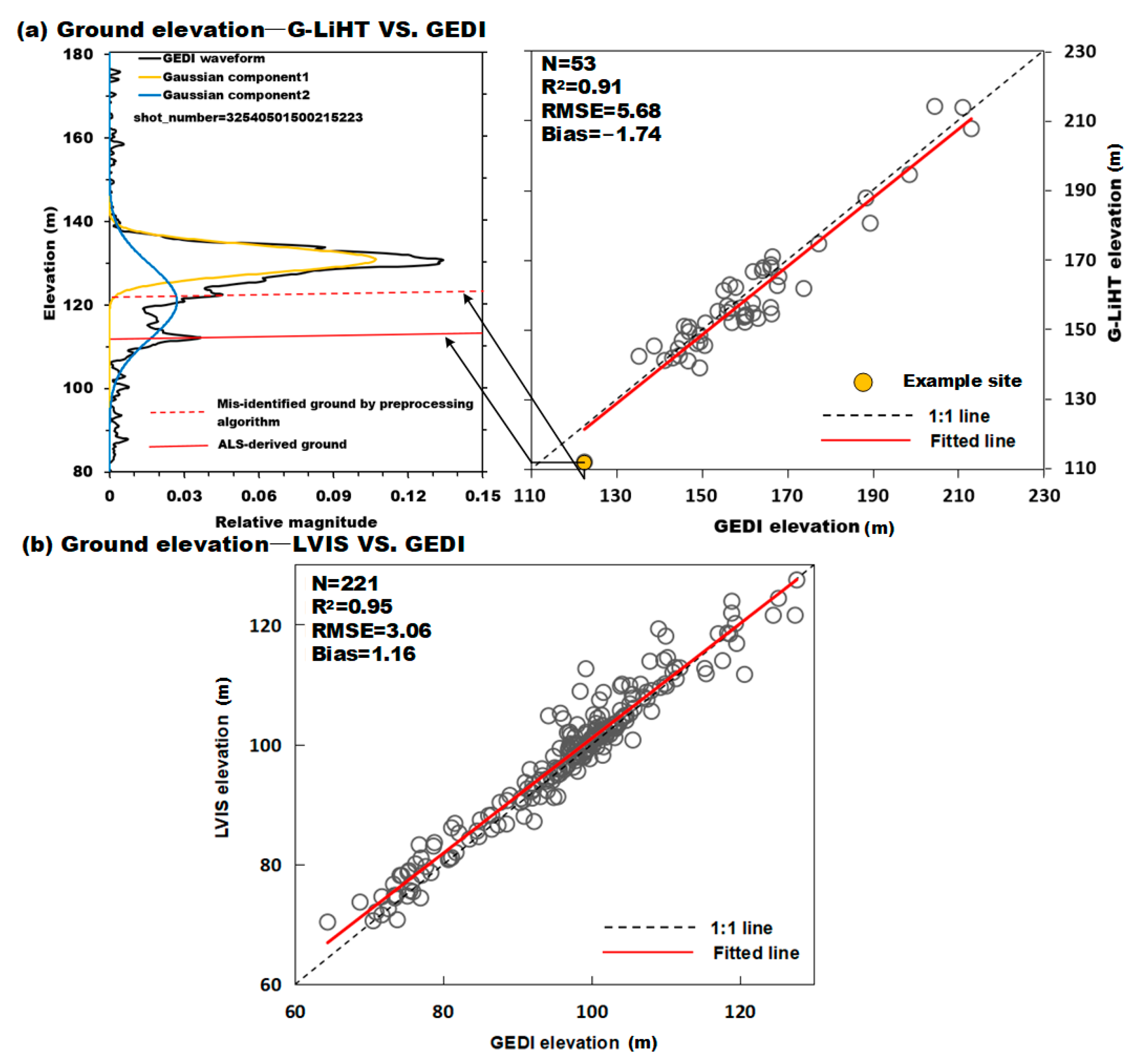
Accurate estimation of forest aboveground biomass (AGB) is vital for informing ecosystem and carbon management. The Global Ecosystem Dynamics Investigation (GEDI) instrument—a new-generation spaceborne lidar system from NASA—provides the first global coverage of high-resolution 3D altimetry data aimed specifically for mapping Earth’s forests, but its performance is yet to be tested for large parts of the world. Here, our goal is to evaluate the accuracies of GEDI in measuring terrain, forest vertical structures, and AGB in reference to independent airborne lidar data over temperate and tropical forests in North America. We compared GEDI-derived elevations and canopy heights (e.g., relative height percentiles such as RH50 and RH100) with those from the Shuttle Radar Topography Mission (SRTM) or from two airborne lidar systems: the Laser Vegetation Imaging Sensor (LVIS) and Goddard’s Lidar, Hyperspectral and Thermal system (G-LiHT). We also estimated GEDI’s geolocation errors by matching GEDI waveforms and G-LiHT pseudo-waveforms. We assessed the predictive power of GEDI metrics in estimating AGB using Random Forests regression. Results showed that GEDI-derived ground elevations correlated strongly those from LVIS, G-LiHT, and LVIS (R2 > 0.91), but with nonnegligible RMSEs of 5.7 m (G-LiHT), 3.1 m (LVIS), and 10.9 m (SRTM). GEDI canopy heights had poorer correlation with LVIS (e.g., R2 = 0.44 for RH100) than with G-LiHT (e.g., R2 = 0.60 for RH100). The estimated horizontal geolocation errors of GEDI footprints averaged 6.5 meters, comparable to the nominal accuracy of 9 m. Correction for the locational errors improved the correlation of GEDI vs G-LiHT canopy heights significantly, on average by 53% (e.g., R2 from 0.57 to 0.82 for RH50). GEDI canopy metrics were useful for predicting AGB (R2 = 0.82 and RMSE = 19.1 Mg/Ha), with the maximum canopy height RH100 being the most useful predictor. Our results highlight the importance of accommodating or correcting for GEDI geolocation errors for estimating forest characteristics and provide empirical evidence on the utility of GEDI for monitoring global biomass dynamics from space.
Keywords: GEDI; airborne lidar; forest structure; ground elevation; aboveground biomass; carbon GEDI; airborne lidar; forest structure; ground elevation; aboveground biomass; carbon